Bridge Statistics for Temple, Pennsylvania (PA)
Condition, Traffic, Stress, Structural Evaluation, Project Costs
- National Bridge Inventory (NBI) Statistics
- 22Number of bridges
- 157ft / 48.0mTotal length
- $1,911,000Total costs
- 181,689Total average daily traffic
- 19,476Total average daily truck traffic
- National Bridge Inventory (NBI) Registered Bridges for Temple
- No street view available for this location
- New bridges - historical statistics
- 11920-1929
- 31930-1939
- 11950-1959
- 51960-1969
- 101970-1979
- 11990-1999
- 12010-2019
- Reconstructed bridges - Historical Statistics
- 22000-2009
- 22010-2019

- Bridge Condition - Deck
- 7.7%Excellent
- 7.7%Very good
- 15.4%Good
- 38.5%Satisfactory
- 23.1%Fair
- 7.7%Poor
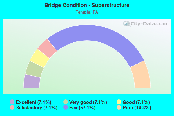
- Bridge Condition - Superstructure
- 7.1%Excellent
- 7.1%Very good
- 7.1%Good
- 7.1%Satisfactory
- 57.1%Fair
- 14.3%Poor
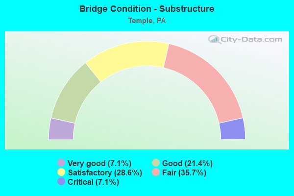
- Bridge Condition - Substructure
- 7.1%Very good
- 21.4%Good
- 28.6%Satisfactory
- 35.7%Fair
- 7.1%Critical
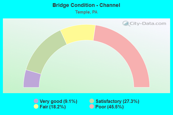
- Bridge Condition - Channel
- 9.1%Very good
- 27.3%Satisfactory
- 18.2%Fair
- 45.5%Poor
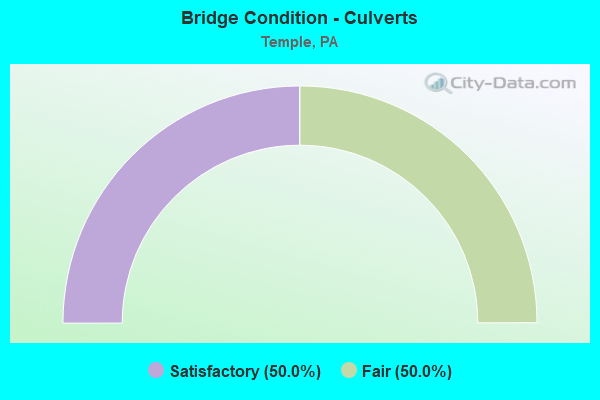
- Bridge Condition - Culverts
- 50.0%Satisfactory
- 50.0%Fair
Find on map >> Show street view
Structure Number: 459, Location: TUCKERTON (Lat: 40.411356, Lng: -75.938261), Route carried "on" structure: State highway 61, Year Built: 1969, Year Reconstructed: 2012, Status: Open, Structure Length: 4.51m (14.80ft), Average Daily Traffic: 24,037 (year 2021), Truck Traffic: 4%, Average Future Daily Traffic: 23,612 (year 2032), Design Load: HS 20, Features Intersected: US 0222 (LR1035)
Minimum Vertical Clearance: 30+ m (98+ ft), Kilometerpoint: 7.429, Lanes on structure: 4, Lanes under structure: 8, Base Highway Network: Yes, Owner: State Highway Agency, Approaching Roadway Width: 23.8m (78.1ft), Skew: 22 degrees, Material/Design: Steel continuous, Design/Construction: Stringer/Multi-beam, Number Of Spans In Main Unit: 2, Length of Maximum Span: 23.8m (78.1ft), Curb or Sidewalk Widths: Left: 0.9m (3.0ft), Right: 0.9m (3.0ft), Curb-To-Curb Width: 22.6m (74.1ft), Out-to-Out Width: 26.4m (86.6ft)
Condition: Deck: Satisfactory, Superstructure: Fair, Substructure: Satisfactory, Operating Rating: 49.9 metric tons, Method Used To Determine Operating Rating: Load and Resistance Factor (LRFR), Inventory Rating: 39.0 metric tons, Method Used To Determine Inventory Rating: Load and Resistance Factor (LRFR), Structural Evaluation: Somewhat better than minimum adequacy, Deck Geometry: Superior to present desirable criteria, Underclear: High priority of corrective action, Approach Roadway Alignment: Equal to present desirable criteria, Bridge Posting: Required (Relationship of Operating Rating to Maximum Legal Load: 0.1 - 9.9% below), Length Of Structure Improvement: 5.50m (18.04ft), Designated Inspection Frequency: Every 24 months, Inspection Date: October 2020, Bridge Improvement Cost: $58,000, Roadway Improvement Cost: $170,000, Total Project Cost: $780,000, Deck Structure Type: Concrete Cast-file-Place, Wearing Surface/Protective System: Wearing Surface: Latex Concrete
Find on map >> Show street view
Structure Number: 4594, Location: 2 MI S OF LEESPORT (Lat: 40.426564, Lng: -75.937086), Route carried "on" structure: State highway 61, Year Built: 1962, Year Reconstructed: 2014, Status: Open, Structure Length: 1.65m (5.41ft), Average Daily Traffic: 28,651 (year 2021), Truck Traffic: 8%, Average Future Daily Traffic: 35,240 (year 2032), Design Load: HL 93, Features Intersected: WILLOW CREEK
Minimum Vertical Clearance: 30+ m (98+ ft), Kilometerpoint: 8.518, Lanes on structure: 4, Base Highway Network: Yes, Owner: State Highway Agency, Approaching Roadway Width: 20.7m (67.9ft), Skew: 21 degrees, Material/Design: Prestressed concrete, Design/Construction: Box Beam or Girders - Single/Spread, Number Of Spans In Main Unit: 1, Length of Maximum Span: 15.2m (49.9ft), Curb or Sidewalk Widths: Left: 0.5m (1.6ft), Right: 0.5m (1.6ft), Curb-To-Curb Width: 20.7m (67.9ft), Out-to-Out Width: 22.4m (73.5ft)
Condition: Deck: Good, Superstructure: Good, Substructure: Good, Channel: Satisfactory, Operating Rating: 52.5 metric tons, Method Used To Determine Operating Rating: Assigned ratings based on Load and Resistance Factor Design (LRFD) reported by rating factor (RF) using HL93 loadings, Inventory Rating: 33.0 metric tons, Method Used To Determine Inventory Rating: Assigned ratings based on Load and Resistance Factor Design (LRFD) reported by rating factor (RF) using HL93 loadings, Structural Evaluation: Better than present minimum criteria, Deck Geometry: Superior to present desirable criteria, Waterway Adequacy: Superior to present desirable criteria, Approach Roadway Alignment: Equal to present desirable criteria, Length Of Structure Improvement: 2.30m (7.55ft), Designated Inspection Frequency: Every 24 months, Inspection Date: September 2020, Bridge Improvement Cost: $21,000, Roadway Improvement Cost: $62,000, Total Project Cost: $284,000, Deck Structure Type: Concrete Cast-file-Place, Wearing Surface/Protective System: Wearing Surface: Monolithic Concrete
Find on map >> Show street view
Structure Number: 4948, Location: MT.LAUREL AVE. (Lat: 40.411072, Lng: -75.916778), Route carried "on" structure: State highway , Year Built: 1969, Status: Open, Structure Length: 1.55m (5.09ft), Average Daily Traffic: 3,302 (year 2020), Truck Traffic: 9%, Average Future Daily Traffic: 4,685 (year 2032), Design Load: HS 20, Features Intersected: LAUREL CREEK, Facility Carried by Structure: SR 1004 (LR 06116)
Minimum Vertical Clearance: 30+ m (98+ ft), Kilometerpoint: 2.045, Lanes on structure: 2, Owner: State Highway Agency, Approaching Roadway Width: 10.4m (34.1ft), Skew: 5 degrees, Material/Design: Concrete, Design/Construction: Culvert, Number Of Spans In Main Unit: 2, Length of Maximum Span: 7.6m (24.9ft), Curb or Sidewalk Widths: Left: 2.4m (7.9ft), Right: 1.5m (4.9ft), Curb-To-Curb Width: 10.4m (34.1ft), Out-to-Out Width: 14.2m (46.6ft)
Condition: Channel: Poor, Culverts: Fair, Operating Rating: 47.2 metric tons, Method Used To Determine Operating Rating: Load Factor (LF), Inventory Rating: 28.1 metric tons, Method Used To Determine Inventory Rating: Load Factor (LF), Structural Evaluation: Somewhat better than minimum adequacy, Deck Geometry: Somewhat better than minimum adequacy, Waterway Adequacy: Equal to present minimum criteria, Approach Roadway Alignment: Equal to present desirable criteria, Length Of Structure Improvement: 2.20m (7.22ft), Designated Inspection Frequency: Every 24 months, Inspection Date: November 2020, Bridge Improvement Cost: $33,000, Roadway Improvement Cost: $96,000, Total Project Cost: $442,000, Deck Structure Type: Concrete Cast-file-Place, Wearing Surface/Protective System: Wearing Surface: Monolithic Concrete
Find on map >> Show street view
Structure Number: 5046, Location: KUTZTOWN ROAD (Lat: 40.406703, Lng: -75.920114), Route carried "on" structure: Spur State highway , Year Built: 1929, Status: Open, Structure Length: 0.88m (2.89ft), Average Daily Traffic: 7,945 (year 2020), Truck Traffic: 3%, Average Future Daily Traffic: 14,537 (year 2032), Design Load: HS 20, Features Intersected: TR.LAUREL CK, Facility Carried by Structure: SR 2011(LR 157 SP)
Minimum Vertical Clearance: 30+ m (98+ ft), Kilometerpoint: 5.168, Lanes on structure: 2, Owner: State Highway Agency, Approaching Roadway Width: 12.2m (40.0ft), Skew: 3 degrees, Material/Design: Concrete, Design/Construction: Tee Beam, Number Of Spans In Main Unit: 1, Length of Maximum Span: 8.2m (26.9ft), Curb or Sidewalk Widths: Left: 2.7m (8.9ft), Right: 2.7m (8.9ft), Curb-To-Curb Width: 12.2m (40.0ft), Out-to-Out Width: 18.3m (60.0ft)
Condition: Deck: Satisfactory, Superstructure: Fair, Substructure: Fair, Channel: Poor, Operating Rating: 42.6 metric tons, Method Used To Determine Operating Rating: Load Factor (LF), Inventory Rating: 25.4 metric tons, Method Used To Determine Inventory Rating: Load Factor (LF), Structural Evaluation: Somewhat better than minimum adequacy, Deck Geometry: Somewhat better than minimum adequacy, Waterway Adequacy: Equal to present minimum criteria, Approach Roadway Alignment: Equal to present desirable criteria, Length Of Structure Improvement: 1.60m (5.25ft), Designated Inspection Frequency: Every 24 months, Inspection Date: November 2020, Bridge Improvement Cost: $18,000, Roadway Improvement Cost: $53,000, Total Project Cost: $244,000, Deck Structure Type: Concrete Cast-file-Place, Wearing Surface/Protective System: Wearing Surface: Bituminous
Find on map >> Show street view
Structure Number: 5206, Location: 0.7 MI N OF PA61 (Lat: 40.418539, Lng: -75.927175), Route carried "on" structure: US 222, Year Built: 1974, Status: Open, Structure Length: 4.45m (14.60ft), Average Daily Traffic: 16,039 (year 2022), Truck Traffic: 15%, Average Future Daily Traffic: 17,660 (year 2032), Design Load: HS 20, Features Intersected: SR 1004(LR 06043)
Minimum Vertical Clearance: 30+ m (98+ ft), Kilometerpoint: 26.324, Lanes on structure: 2, Lanes under structure: 2, Base Highway Network: Yes, Owner: State Highway Agency, Approaching Roadway Width: 17.1m (56.1ft), Skew: 11 degrees, Material/Design: Prestressed concrete, Design/Construction: Box Beam or Girders - Single/Spread, Number Of Spans In Main Unit: 3, Length of Maximum Span: 21.0m (68.9ft), Curb-To-Curb Width: 12.0m (39.4ft), Out-to-Out Width: 13.2m (43.3ft)
Condition: Deck: Satisfactory, Superstructure: Fair, Substructure: Satisfactory, Operating Rating: 66.2 metric tons, Method Used To Determine Operating Rating: Load Factor (LF), Inventory Rating: 30.8 metric tons, Method Used To Determine Inventory Rating: Load Factor (LF), Structural Evaluation: Somewhat better than minimum adequacy, Deck Geometry: Equal to present minimum criteria, Underclear: Equal to present minimum criteria, Approach Roadway Alignment: Equal to present desirable criteria, Length Of Structure Improvement: 5.40m (17.72ft), Designated Inspection Frequency: Every 24 months, Inspection Date: November 2020, Deck Structure Type: Concrete Cast-file-Place, Wearing Surface/Protective System: Wearing Surface: Monolithic Concrete
Find on map >> Show street view
Structure Number: 5208, Location: 0.7 MI.N.OF PA61 (Lat: 40.418725, Lng: -75.927314), Route carried "on" structure: US 222, Year Built: 1974, Status: Open, Structure Length: 4.69m (15.39ft), Average Daily Traffic: 14,657 (year 2022), Truck Traffic: 16%, Average Future Daily Traffic: 20,990 (year 2032), Design Load: HS 20, Features Intersected: SR 1004(LR 06043)
Minimum Vertical Clearance: 30+ m (98+ ft), Kilometerpoint: 26.345, Lanes on structure: 2, Lanes under structure: 2, Base Highway Network: Yes, Owner: State Highway Agency, Approaching Roadway Width: 17.1m (56.1ft), Skew: 11 degrees, Material/Design: Prestressed concrete, Design/Construction: Box Beam or Girders - Single/Spread, Number Of Spans In Main Unit: 3, Length of Maximum Span: 21.0m (68.9ft), Curb-To-Curb Width: 12.0m (39.4ft), Out-to-Out Width: 13.2m (43.3ft)
Condition: Deck: Satisfactory, Superstructure: Fair, Substructure: Satisfactory, Operating Rating: 66.2 metric tons, Method Used To Determine Operating Rating: Load Factor (LF), Inventory Rating: 28.1 metric tons, Method Used To Determine Inventory Rating: Load Factor (LF), Structural Evaluation: Somewhat better than minimum adequacy, Deck Geometry: Equal to present minimum criteria, Underclear: Superior to present desirable criteria, Approach Roadway Alignment: Equal to present desirable criteria, Length Of Structure Improvement: 5.60m (18.37ft), Designated Inspection Frequency: Every 24 months, Inspection Date: November 2020, Deck Structure Type: Concrete Cast-file-Place, Wearing Surface/Protective System: Wearing Surface: Monolithic Concrete
Find on map >> Show street view
Structure Number: 5209, Location: 0.5 MI.S.OF PA 12 (Lat: 40.424911, Lng: -75.919347), Route carried "on" structure: US 222, Year Built: 1974, Status: Open, Structure Length: 3.99m (13.09ft), Average Daily Traffic: 16,039 (year 2022), Truck Traffic: 15%, Average Future Daily Traffic: 17,660 (year 2032), Design Load: HS 20, Features Intersected: T-707(WILLOW CK.RD.)
Minimum Vertical Clearance: 30+ m (98+ ft), Kilometerpoint: 27.304, Lanes on structure: 2, Lanes under structure: 2, Base Highway Network: Yes, Owner: State Highway Agency, Approaching Roadway Width: 12.2m (40.0ft), Skew: 11 degrees, Material/Design: Prestressed concrete, Design/Construction: Box Beam or Girders - Single/Spread, Number Of Spans In Main Unit: 3, Length of Maximum Span: 18.6m (61.0ft), Curb-To-Curb Width: 12.0m (39.4ft), Out-to-Out Width: 13.2m (43.3ft)
Condition: Deck: Satisfactory, Superstructure: Fair, Substructure: Fair, Operating Rating: 79.8 metric tons, Method Used To Determine Operating Rating: Load Factor (LF), Inventory Rating: 34.5 metric tons, Method Used To Determine Inventory Rating: Load Factor (LF), Structural Evaluation: Somewhat better than minimum adequacy, Deck Geometry: Equal to present minimum criteria, Underclear: Somewhat better than minimum adequacy, Approach Roadway Alignment: Equal to present desirable criteria, Length Of Structure Improvement: 4.80m (15.75ft), Designated Inspection Frequency: Every 24 months, Inspection Date: December 2020, Deck Structure Type: Concrete Cast-file-Place, Wearing Surface/Protective System: Wearing Surface: Monolithic Concrete
Find on map >> Show street view
Structure Number: 5212, Location: 0.5 MI.S.OF PA 12 (Lat: 40.425089, Lng: -75.919497), Route carried "on" structure: US 222, Year Built: 1974, Status: Open, Structure Length: 4.08m (13.39ft), Average Daily Traffic: 14,657 (year 2022), Truck Traffic: 16%, Average Future Daily Traffic: 20,990 (year 2032), Design Load: HS 20, Features Intersected: T-707(WILLOW CK.RD.)
Minimum Vertical Clearance: 30+ m (98+ ft), Kilometerpoint: 27.323, Lanes on structure: 2, Lanes under structure: 2, Base Highway Network: Yes, Owner: State Highway Agency, Approaching Roadway Width: 12.2m (40.0ft), Skew: 11 degrees, Material/Design: Prestressed concrete, Design/Construction: Box Beam or Girders - Single/Spread, Number Of Spans In Main Unit: 3, Length of Maximum Span: 18.6m (61.0ft), Curb-To-Curb Width: 12.0m (39.4ft), Out-to-Out Width: 13.2m (43.3ft)
Condition: Deck: Fair, Superstructure: Fair, Substructure: Fair, Operating Rating: 79.8 metric tons, Method Used To Determine Operating Rating: Load Factor (LF), Inventory Rating: 34.5 metric tons, Method Used To Determine Inventory Rating: Load Factor (LF), Structural Evaluation: Somewhat better than minimum adequacy, Deck Geometry: Equal to present minimum criteria, Underclear: Equal to present minimum criteria, Approach Roadway Alignment: Equal to present desirable criteria, Length Of Structure Improvement: 4.90m (16.08ft), Designated Inspection Frequency: Every 24 months, Inspection Date: December 2020, Deck Structure Type: Concrete Cast-file-Place, Wearing Surface/Protective System: Wearing Surface: Monolithic Concrete
Find on map >> Show street view
Structure Number: 5278, Location: CROSS KEYS ROAD (Lat: 40.414706, Lng: -75.939806), Route carried "on" structure: State highway , Year Built: 1973, Status: Open, Structure Length: 10.76m (35.30ft), Average Daily Traffic: 2,531 (year 2022), Truck Traffic: 4%, Average Future Daily Traffic: 3,685 (year 2032), Design Load: HS 20, Features Intersected: SCHUYLKILL RIVER, Facility Carried by Structure: SR 4030 (LR 06043)
Minimum Vertical Clearance: 30+ m (98+ ft), Kilometerpoint: 10.021, Lanes on structure: 2, Owner: State Highway Agency, Approaching Roadway Width: 13.7m (44.9ft), Skew: 2 degrees, Material/Design: Prestressed concrete, Design/Construction: Stringer/Multi-beam, Number Of Spans In Main Unit: 4, Length of Maximum Span: 26.5m (86.9ft), Curb-To-Curb Width: 13.4m (44.0ft), Out-to-Out Width: 14.6m (47.9ft)
Condition: Deck: Fair, Superstructure: Satisfactory, Substructure: Fair, Channel: Fair, Operating Rating: 91.6 metric tons, Method Used To Determine Operating Rating: Load Factor (LF), Inventory Rating: 28.1 metric tons, Method Used To Determine Inventory Rating: Load Factor (LF), Structural Evaluation: Somewhat better than minimum adequacy, Deck Geometry: Better than present minimum criteria, Waterway Adequacy: Superior to present desirable criteria, Approach Roadway Alignment: Equal to present desirable criteria, Length Of Structure Improvement: 11.70m (38.39ft), Designated Inspection Frequency: Every 24 months, Underwater Inspection Frequency: Every 60 months, Inspection Date: July 2020, Underwater Inspection Date: October 2018, Deck Structure Type: Concrete Cast-file-Place, Wearing Surface/Protective System: Wearing Surface: Monolithic Concrete
Find on map >> Show street view
Structure Number: 5306, Location: TEMPLE (Lat: 40.411836, Lng: -75.914794), Route carried "on" structure: City street , Year Built: 1976, Status: Posted for load, Structure Length: 0.82m (2.69ft), Average Daily Traffic: 150 (year 1989), Truck Traffic: 1%, Average Future Daily Traffic: 210 (year 2009), Design Load: HS 20, Features Intersected: LAUREL RUN, Facility Carried by Structure: MOUNTAINSIDE ROAD
Minimum Vertical Clearance: 30+ m (98+ ft), Kilometerpoint: 0.000, Lanes on structure: 2, Owner: Town or Township Highway Agency, Approaching Roadway Width: 7.6m (24.9ft), Skew: 4 degrees, Material/Design: Concrete, Design/Construction: Culvert, Number Of Spans In Main Unit: 1, Length of Maximum Span: 8.2m (26.9ft), Curb or Sidewalk Widths: Left: 0.2m (0.7ft), Right: 0.2m (0.7ft), Curb-To-Curb Width: 10.3m (33.8ft), Out-to-Out Width: 11.4m (37.4ft)
Condition: Channel: Satisfactory, Culverts: Satisfactory, Operating Rating: 29.9 metric tons, Method Used To Determine Operating Rating: Load Factor (LF), Inventory Rating: 18.1 metric tons, Method Used To Determine Inventory Rating: Load Factor (LF), Structural Evaluation: Somewhat better than minimum adequacy, Deck Geometry: Better than present minimum criteria, Waterway Adequacy: Equal to present minimum criteria, Approach Roadway Alignment: Equal to present desirable criteria, Bridge Posting: Required (Relationship of Operating Rating to Maximum Legal Load: > 39.9% below), Length Of Structure Improvement: 1.40m (4.59ft), Designated Inspection Frequency: Every 24 months, Other Special Inspection Frequency: Every 12 months, Inspection Date: September 2020, Other Special Inspection Date: September 2021
Find on map >> Show street view
Structure Number: 5425, Location: 500 FT WEST RTE 61 (Lat: 40.427108, Lng: -75.938750), Route carried "on" structure: City street , Year Built: 1934, Status: Open, Structure Length: 1.83m (6.00ft), Average Daily Traffic: 390 (year 2020), Truck Traffic: 1%, Average Future Daily Traffic: 400 (year 2025), Features Intersected: WILLOW CREEK, Facility Carried by Structure: BERKLEY RD.
Minimum Vertical Clearance: 30+ m (98+ ft), Kilometerpoint: 0.000, Lanes on structure: 2, Owner: County Highway Agency, Approaching Roadway Width: 9.1m (29.9ft), Material/Design: Concrete, Design/Construction: Arch - Deck, Number Of Spans In Main Unit: 1, Length of Maximum Span: 18.3m (60.0ft), Curb or Sidewalk Widths: Left: 0.3m (1.0ft), Right: 0.3m (1.0ft), Curb-To-Curb Width: 13.4m (44.0ft), Out-to-Out Width: 14.3m (46.9ft)
Condition: Superstructure: Poor, Substructure: Fair, Channel: Poor, Operating Rating: 54.4 metric tons, Method Used To Determine Operating Rating: Field evaluation and documented engineering judgment, Inventory Rating: 32.7 metric tons, Method Used To Determine Inventory Rating: Field evaluation and documented engineering judgment, Structural Evaluation: Meets minimum limits, Deck Geometry: Superior to present desirable criteria, Waterway Adequacy: Better than present minimum criteria, Approach Roadway Alignment: Equal to present desirable criteria, Designated Inspection Frequency: Every 24 months, Underwater Inspection Frequency: Every 24 months, Inspection Date: May 2020, Underwater Inspection Date: November 2020
Find on map >> Show street view
Structure Number: 5505, Location: 8TH AVE AND COLUMBIA AVE. (Lat: 40.407494, Lng: -75.921350), Route carried "on" structure: Business City street , Year Built: 1935, Status: Open, Structure Length: 1.34m (4.40ft), Average Daily Traffic: 200 (year 2012), Average Future Daily Traffic: 250 (year 2022), Features Intersected: LAUREL RUN CREEK, Facility Carried by Structure: 8TH AVENUE
Minimum Vertical Clearance: 30+ m (98+ ft), Kilometerpoint: 0.000, Lanes on structure: 2, Owner: Town or Township Highway Agency, Approaching Roadway Width: 10.4m (34.1ft), Skew: 4 degrees, Material/Design: Concrete continuous, Design/Construction: Slab, Number Of Spans In Main Unit: 3, Length of Maximum Span: 4.0m (13.1ft), Curb or Sidewalk Widths: Left: 1.5m (4.9ft), Right: 1.5m (4.9ft), Curb-To-Curb Width: 10.4m (34.1ft), Out-to-Out Width: 13.4m (44.0ft)
Condition: Deck: Fair, Superstructure: Fair, Substructure: Critical, Channel: Poor, Operating Rating: 63.5 metric tons, Method Used To Determine Operating Rating: Field evaluation and documented engineering judgment, Inventory Rating: 38.1 metric tons, Method Used To Determine Inventory Rating: Field evaluation and documented engineering judgment, Structural Evaluation: High priority of replacement, Deck Geometry: Better than present minimum criteria, Waterway Adequacy: Better than present minimum criteria, Approach Roadway Alignment: Equal to present desirable criteria, Length Of Structure Improvement: 1.30m (4.27ft), Designated Inspection Frequency: Every 24 months, Other Special Inspection Frequency: Every 6 months, Inspection Date: June 2021, Other Special Inspection Date: June 2021, Bridge Improvement Cost: $6,000, Roadway Improvement Cost: $16,000, Total Project Cost: $75,000, Deck Structure Type: Concrete Cast-file-Place, Wearing Surface/Protective System: Wearing Surface: Bituminous
Find on map >> Show street view
Structure Number: 5506, Location: 8TH AVE AND SHALTER AVE. (Lat: 40.406572, Lng: -75.921300), Route carried "on" structure: Business City street , Year Built: 1935, Status: Open, Structure Length: 1.43m (4.69ft), Average Daily Traffic: 200 (year 2012), Average Future Daily Traffic: 250 (year 2022), Features Intersected: SHALTER AVENUE FLOODWAY, Facility Carried by Structure: 8TH AVENUE
Minimum Vertical Clearance: 30+ m (98+ ft), Kilometerpoint: 0.000, Lanes on structure: 2, Owner: Town or Township Highway Agency, Approaching Roadway Width: 10.4m (34.1ft), Material/Design: Concrete continuous, Design/Construction: Slab, Number Of Spans In Main Unit: 4, Length of Maximum Span: 3.4m (11.2ft), Curb or Sidewalk Widths: Left: 1.5m (4.9ft), Right: 1.5m (4.9ft), Curb-To-Curb Width: 10.4m (34.1ft), Out-to-Out Width: 13.4m (44.0ft)
Condition: Deck: Poor, Superstructure: Poor, Substructure: Satisfactory, Channel: Satisfactory, Operating Rating: 50.8 metric tons, Method Used To Determine Operating Rating: Field evaluation and documented engineering judgment, Inventory Rating: 29.9 metric tons, Method Used To Determine Inventory Rating: Field evaluation and documented engineering judgment, Structural Evaluation: Meets minimum limits, Deck Geometry: Better than present minimum criteria, Waterway Adequacy: Better than present minimum criteria, Approach Roadway Alignment: Equal to present desirable criteria, Length Of Structure Improvement: 1.40m (4.59ft), Designated Inspection Frequency: Every 24 months, Inspection Date: August 2020, Bridge Improvement Cost: $6,000, Roadway Improvement Cost: $19,000, Total Project Cost: $86,000, Deck Structure Type: Concrete Cast-file-Place, Wearing Surface/Protective System: Wearing Surface: Bituminous
Find on map >> Show street view
Structure Number: 5507, Location: SOUTH TEMPLE (Lat: 40.403575, Lng: -75.923456), Route carried "on" structure: City street , Year Built: 1959, Year Reconstructed: 2015, Status: Open, Structure Length: 1.83m (6.00ft), Average Daily Traffic: 2,201 (year 2020), Truck Traffic: 4%, Average Future Daily Traffic: 2,218 (year 2025), Design Load: HL 93, Features Intersected: LAUREL RUN, Facility Carried by Structure: WATER STREET
Minimum Vertical Clearance: 30+ m (98+ ft), Kilometerpoint: 0.000, Lanes on structure: 2, Owner: County Highway Agency, Approaching Roadway Width: 9.1m (29.9ft), Skew: 3 degrees, Material/Design: Prestressed concrete, Design/Construction: Box Beam or Girders - Single/Spread, Number Of Spans In Main Unit: 1, Length of Maximum Span: 17.7m (58.1ft), Curb or Sidewalk Widths: Left: 2.4m (7.9ft), Right: 2.4m (7.9ft), Curb-To-Curb Width: 9.1m (29.9ft), Out-to-Out Width: 14.0m (45.9ft)
Condition: Deck: Very good, Superstructure: Very good, Substructure: Good, Channel: Fair, Operating Rating: 42.1 metric tons, Method Used To Determine Operating Rating: Assigned ratings based on Load and Resistance Factor Design (LRFD) reported by rating factor (RF) using HL93 loadings, Inventory Rating: 32.7 metric tons, Method Used To Determine Inventory Rating: Assigned ratings based on Load and Resistance Factor Design (LRFD) reported by rating factor (RF) using HL93 loadings, Structural Evaluation: Better than present minimum criteria, Deck Geometry: Meets minimum limits, Waterway Adequacy: Better than present minimum criteria, Approach Roadway Alignment: Equal to present desirable criteria, Length Of Structure Improvement: 2.50m (8.20ft), Designated Inspection Frequency: Every 24 months, Inspection Date: November 2021, Wearing Surface/Protective System: Wearing Surface: Monolithic Concrete, Deck Protection: Epoxy Coated Reinforcing
Find on map >> Show street view
Structure Number: 19832, Location: 0.1 MILE EAST OF SR119 (Lat: 41.000256, Lng: -78.839519), Route carried "on" structure: City street , Year Built: 1991, Year Reconstructed: 2016, Status: Open, Structure Length: 2.04m (6.69ft), Average Daily Traffic: 50 (year 2021), Truck Traffic: 9%, Average Future Daily Traffic: 70 (year 2041), Design Load: HS 25 or greater, Features Intersected: STUMP CREEK, Facility Carried by Structure: T-513 PIKE RD
Minimum Vertical Clearance: 30+ m (98+ ft), Kilometerpoint: 0.000, Lanes on structure: 2, Owner: County Highway Agency, Approaching Roadway Width: 6.4m (21.0ft), Skew: 2 degrees, Material/Design: Prestressed concrete, Design/Construction: Box Beam or Girders - Multiple, Number Of Spans In Main Unit: 1, Length of Maximum Span: 19.8m (65.0ft), Curb or Sidewalk Widths: Left: 0.2m (0.7ft), Right: 0.2m (0.7ft), Curb-To-Curb Width: 7.6m (24.9ft), Out-to-Out Width: 8.6m (28.2ft)
Condition: Deck: Good, Superstructure: Fair, Substructure: Good, Channel: Poor, Inventory Rating: 45.4 metric tons, Method Used To Determine Inventory Rating: Load Factor (LF), Structural Evaluation: Somewhat better than minimum adequacy, Deck Geometry: Equal to present minimum criteria, Waterway Adequacy: Equal to present desirable criteria, Approach Roadway Alignment: Equal to present minimum criteria, Length Of Structure Improvement: 2.70m (8.86ft), Designated Inspection Frequency: Every 24 months, Inspection Date: June 2021, Deck Structure Type: Concrete Cast-file-Place, Wearing Surface/Protective System: Wearing Surface: Monolithic Concrete, Deck Protection: Epoxy Coated Reinforcing
Find on map >> Show street view
Structure Number: 54091, Location: WILLOW CREEK BRIDGE (Lat: 40.427028, Lng: -75.934028), Route carried "on" structure: State highway , Year Built: 2017, Status: Open, Structure Length: 2.16m (7.09ft), Average Daily Traffic: 4,038 (year 2021), Truck Traffic: 4%, Average Future Daily Traffic: 6,527 (year 2037), Design Load: HL 93, Features Intersected: Willow Creek, Facility Carried by Structure: LEESPORT AVE
Minimum Vertical Clearance: 30+ m (98+ ft), Kilometerpoint: 0.000, Lanes on structure: 2, Owner: State Highway Agency, Maintenance Responsibility: Private, Approaching Roadway Width: 6.7m (22.0ft), Material/Design: Prestressed concrete, Design/Construction: Box Beam or Girders - Multiple, Number Of Spans In Main Unit: 1, Length of Maximum Span: 20.4m (66.9ft), Curb-To-Curb Width: 9.2m (30.2ft), Out-to-Out Width: 9.8m (32.2ft)
Condition: Deck: Excellent, Superstructure: Excellent, Substructure: Very good, Channel: Very good, Operating Rating: 59.9 metric tons, Method Used To Determine Operating Rating: Assigned ratings based on Load and Resistance Factor Design (LRFD) reported by rating factor (RF) using HL93 loadings, Inventory Rating: 46.3 metric tons, Method Used To Determine Inventory Rating: Assigned ratings based on Load and Resistance Factor Design (LRFD) reported by rating factor (RF) using HL93 loadings, Structural Evaluation: Equal to present desirable criteria, Deck Geometry: Meets minimum limits, Waterway Adequacy: Meets minimum limits, Approach Roadway Alignment: Equal to present desirable criteria, Designated Inspection Frequency: Every 24 months, Inspection Date: September 2020, Deck Structure Type: Concrete Cast-file-Place, Wearing Surface/Protective System: Wearing Surface: Integral Concrete, Deck Protection: Epoxy Coated Reinforcing
Find on map >> Show street view
Structure Number: 459, Location: TUCKERTON (Lat: 40.411356, Lng: -75.938261), Route carried "under" structure: US 222, Year Built: 1969, Structure Length: 0. m, Average Daily Traffic: 16,039 (year 2022), Truck Traffic: 15%, Features Intersected: US 0222 (LR1035), Facility Carried by Structure: PA 61(LR.160)
Minimum Vertical Clearance: 6.22m (20.41ft), Kilometerpoint: 25.088, Lanes on structure: 4, Lanes under structure: 4, Material/Design: Steel continuous, Design/Construction: Stringer/Multi-beam, Length of Maximum Span: 23.8m (78.1ft)
Find on map >> Show street view
Structure Number: 459, Location: TUCKERTON (Lat: 40.411356, Lng: -75.938261), Route carried "under" structure: US 222, Year Built: 1969, Structure Length: 0. m, Average Daily Traffic: 14,657 (year 2022), Truck Traffic: 16%, Features Intersected: US 0222 (LR1035), Facility Carried by Structure: PA 61(LR.160)
Minimum Vertical Clearance: 4.80m (15.75ft), Kilometerpoint: 25.120, Lanes on structure: 4, Lanes under structure: 4, Material/Design: Steel continuous, Design/Construction: Stringer/Multi-beam, Length of Maximum Span: 23.8m (78.1ft)
Find on map >> Show street view
Structure Number: 5206, Location: 0.7 MI N OF PA61 (Lat: 40.418539, Lng: -75.927175), Route carried "under" structure: State highway , Year Built: 1974, Structure Length: 0. m, Average Daily Traffic: 6,753 (year 2020), Truck Traffic: 8%, Features Intersected: SR 1004(LR 06043), Facility Carried by Structure: SR 0222 NB(LR1035)
Minimum Vertical Clearance: 4.57m (14.99ft), Kilometerpoint: 1.207, Lanes on structure: 2, Lanes under structure: 2, Material/Design: Prestressed concrete, Design/Construction: Box Beam or Girders - Single/Spread, Length of Maximum Span: 21.0m (68.9ft)
Find on map >> Show street view
Structure Number: 5208, Location: 0.7 MI.N.OF PA61 (Lat: 40.418725, Lng: -75.927314), Route carried "under" structure: State highway , Year Built: 1974, Structure Length: 0. m, Average Daily Traffic: 6,753 (year 2020), Truck Traffic: 8%, Features Intersected: SR 1004(LR 06043), Facility Carried by Structure: US 222 (LR 1035)
Minimum Vertical Clearance: 5.18m (16.99ft), Kilometerpoint: 1.207, Lanes on structure: 2, Lanes under structure: 2, Material/Design: Prestressed concrete, Design/Construction: Box Beam or Girders - Single/Spread, Length of Maximum Span: 21.0m (68.9ft)
Find on map >> Show street view
Structure Number: 5209, Location: 0.5 MI.S.OF PA 12 (Lat: 40.424911, Lng: -75.919347), Route carried "under" structure: City street , Year Built: 1974, Structure Length: 0. m, Average Daily Traffic: 1,200 (year 1996), Features Intersected: T-707(WILLOW CK.RD.), Facility Carried by Structure: SR 222 (LR 1035)
Minimum Vertical Clearance: 4.37m (14.34ft), Kilometerpoint: 0.000, Lanes on structure: 2, Lanes under structure: 2, Material/Design: Prestressed concrete, Design/Construction: Box Beam or Girders - Single/Spread, Length of Maximum Span: 18.6m (61.0ft)
Find on map >> Show street view
Structure Number: 5212, Location: 0.5 MI.S.OF PA 12 (Lat: 40.425089, Lng: -75.919497), Route carried "under" structure: City street , Year Built: 1974, Structure Length: 0. m, Average Daily Traffic: 1,200 (year 1994), Features Intersected: T-707(WILLOW CK.RD.), Facility Carried by Structure: SR 0222(LR 1035)
Minimum Vertical Clearance: 4.69m (15.39ft), Kilometerpoint: 0.000, Lanes on structure: 2, Lanes under structure: 2, Material/Design: Prestressed concrete, Design/Construction: Box Beam or Girders - Single/Spread, Length of Maximum Span: 18.6m (61.0ft)