Bridge Statistics for Tewksbury, Massachusetts (MA)
Condition, Traffic, Stress, Structural Evaluation, Project Costs
- National Bridge Inventory (NBI) Statistics
- 15Number of bridges
- 184ft / 55.8mTotal length
- $67,235,000Total costs
- 789,675Total average daily traffic
- 57,891Total average daily truck traffic
- National Bridge Inventory (NBI) Registered Bridges for Tewksbury
- No street view available for this location
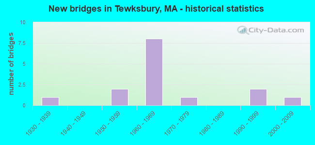
- New bridges - historical statistics
- 11930-1939
- 21950-1959
- 81960-1969
- 11970-1979
- 21990-1999
- 12000-2009
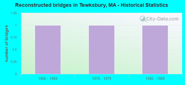
- Reconstructed bridges - Historical Statistics
- 11960-1969
- 11970-1979
- 11980-1989
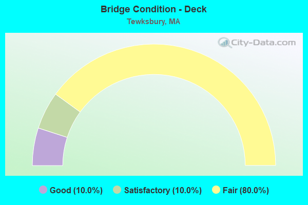
- Bridge Condition - Deck
- 10.0%Good
- 10.0%Satisfactory
- 80.0%Fair
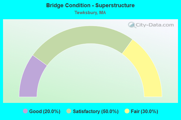
- Bridge Condition - Superstructure
- 20.0%Good
- 50.0%Satisfactory
- 30.0%Fair
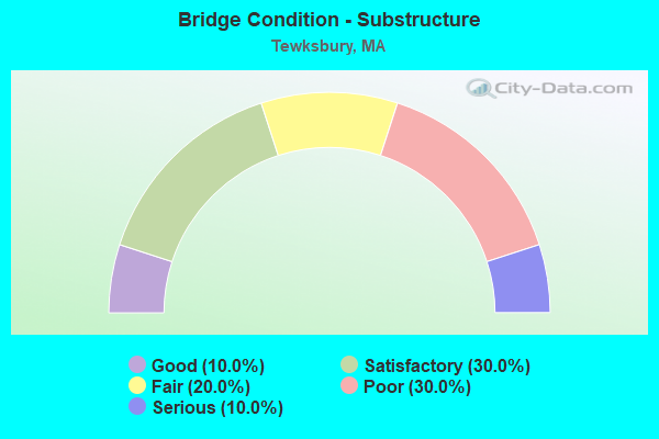
- Bridge Condition - Substructure
- 10.0%Good
- 30.0%Satisfactory
- 20.0%Fair
- 30.0%Poor
- 10.0%Serious
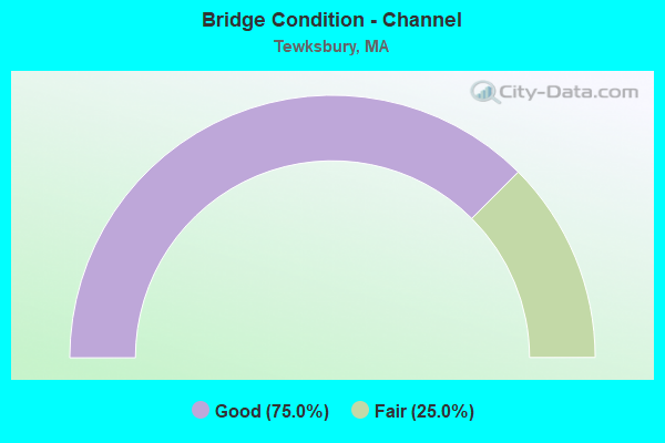
- Bridge Condition - Channel
- 75.0%Good
- 25.0%Fair
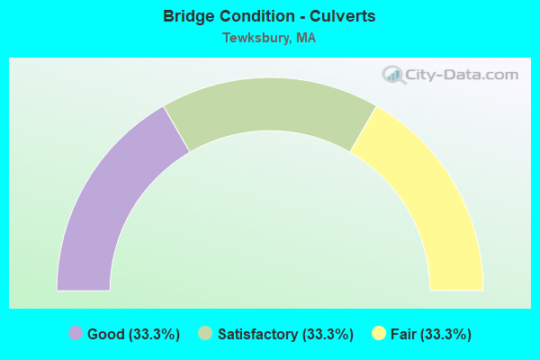
- Bridge Condition - Culverts
- 33.3%Good
- 33.3%Satisfactory
- 33.3%Fair
Find on map >> Show street view
Structure Number: T03002AE3DOTNBI, Location: .24 KM SELY SHAWSHEEN ST. (Lat: 42.587883, Lng: -71.200600), Route carried "on" structure: State highway 38, Year Built: 1997, Status: Open, Structure Length: 2.21m (7.25ft), Average Daily Traffic: 21,500 (year 2019), Truck Traffic: 10%, Average Future Daily Traffic: 31,112 (year 2032), Design Load: HS 20, Features Intersected: WATER SHAWSHEEN RIVER
Minimum Vertical Clearance: 30+ m (98+ ft), Kilometerpoint: 25.353, Lanes on structure: 2, Base Highway Network: Yes, Owner: State Highway Agency, Approaching Roadway Width: 13.4m (44.0ft), Skew: 1 degrees, Material/Design: Prestressed concrete, Design/Construction: Box Beam or Girders - Single/Spread, Number Of Spans In Main Unit: 1, Length of Maximum Span: 20.7m (67.9ft), Curb or Sidewalk Widths: Left: 1.5m (4.9ft), Right: 0.0m, Curb-To-Curb Width: 13.4m (44.0ft), Out-to-Out Width: 15.7m (51.5ft)
Condition: Deck: Good, Superstructure: Good, Substructure: Good, Channel: Good, Operating Rating: 78.4 metric tons, Method Used To Determine Operating Rating: Load Factor (LF), Inventory Rating: 42.5 metric tons, Method Used To Determine Inventory Rating: Load Factor (LF), Structural Evaluation: Better than present minimum criteria, Deck Geometry: Equal to present minimum criteria, Waterway Adequacy: Equal to present desirable criteria, Approach Roadway Alignment: Equal to present desirable criteria, Designated Inspection Frequency: Every 24 months, Inspection Date: October 2021, Deck Structure Type: Concrete Cast-file-Place, Wearing Surface/Protective System: Wearing Surface: Monolithic Concrete, Deck Protection: Epoxy Coated Reinforcing
Find on map >> Show street view
Structure Number: T030032D5MUNNBI, Location: 1 MI. N. OF RT. 38 (Lat: 42.599750, Lng: -71.192969), Route carried "on" structure: City street , Year Built: 1998, Status: Open, Structure Length: 1.49m (4.89ft), Average Daily Traffic: 170 (year 2018), Truck Traffic: 6%, Average Future Daily Traffic: 268 (year 2032), Features Intersected: WATER SHAWSHEEN RIVER, Facility Carried by Structure: HWY MILL ST
Minimum Vertical Clearance: 30+ m (98+ ft), Kilometerpoint: 0.000, Lanes on structure: 2, Owner: Town or Township Highway Agency, Approaching Roadway Width: 9.1m (29.9ft), Material/Design: Concrete, Design/Construction: Culvert, Number Of Spans In Main Unit: 2, Length of Maximum Span: 3.7m (12.1ft)
Condition: Channel: Good, Culverts: Good, Operating Rating: 48.6 metric tons, Method Used To Determine Operating Rating: Load and Resistance Factor Rating (LRFR) rating reported by rating factor(RF) method using HL-93 loadings, Inventory Rating: 38.9 metric tons, Method Used To Determine Inventory Rating: Load and Resistance Factor Rating (LRFR) rating reported by rating factor(RF) method using HL-93 loadings, Structural Evaluation: Better than present minimum criteria, Waterway Adequacy: Better than present minimum criteria, Approach Roadway Alignment: Better than present minimum criteria, Length Of Structure Improvement: 0.20m (0.66ft), Designated Inspection Frequency: Every 12 months, Underwater Inspection Frequency: Every 12 months, Inspection Date: June 2021, Underwater Inspection Date: Febuary 2021, Bridge Improvement Cost: $281,000, Roadway Improvement Cost: $29,000, Total Project Cost: $422,000 ( Estimate for 2022), Wearing Surface/Protective System: Wearing Surface: Bituminous
Find on map >> Show street view
Structure Number: T030042C7MUNNBI, Location: 1 MI NW OF WILMINGTON (Lat: 42.594556, Lng: -71.195622), Route carried "on" structure: City street , Year Built: 1979, Status: Open, Structure Length: 1.37m (4.49ft), Average Daily Traffic: 3,800 (year 2018), Truck Traffic: 7%, Average Future Daily Traffic: 5,054 (year 2033), Features Intersected: WATER SHAWSHEEN RIVER, Facility Carried by Structure: HWY BRIDGE ST
Minimum Vertical Clearance: 30+ m (98+ ft), Kilometerpoint: 0.129, Lanes on structure: 2, Owner: Town or Township Highway Agency, Approaching Roadway Width: 7.3m (24.0ft), Material/Design: Steel, Design/Construction: Culvert, Number Of Spans In Main Unit: 3, Length of Maximum Span: 4.3m (14.1ft), Curb-To-Curb Width: 7.3m (24.0ft), Out-to-Out Width: 10.4m (34.1ft)
Condition: Channel: Fair, Culverts: Fair, Structural Evaluation: Somewhat better than minimum adequacy, Deck Geometry: High priority of replacement, Waterway Adequacy: Better than present minimum criteria, Approach Roadway Alignment: Equal to present minimum criteria, Length Of Structure Improvement: 0.80m (2.62ft), Designated Inspection Frequency: Every 12 months, Underwater Inspection Frequency: Every 12 months, Inspection Date: March 2020, Underwater Inspection Date: August 2021, Bridge Improvement Cost: $431,000, Roadway Improvement Cost: $44,000, Total Project Cost: $647,000 ( Estimate for 2022)
Find on map >> Show street view
Structure Number: T030082NGDOT634, Location: 0.4 MI SELY RT 495 (Lat: 42.624653, Lng: -71.266633), Route carried "on" structure: State highway 38, Year Built: 1938, Year Reconstructed: 1991, Status: Open, Structure Length: 4.82m (15.81ft), Average Daily Traffic: 29,095 (year 2018), Truck Traffic: 11%, Average Future Daily Traffic: 44,378 (year 2031), Design Load: H 20, Features Intersected: RR BMRR
Minimum Vertical Clearance: 5.49m (18.01ft), Kilometerpoint: 32.349, Lanes on structure: 2, Base Highway Network: Yes, Owner: State Highway Agency, Approaching Roadway Width: 14.0m (45.9ft), Skew: 4 degrees, Material/Design: Steel continuous, Design/Construction: Stringer/Multi-beam, Number Of Spans In Main Unit: 3, Length of Maximum Span: 15.5m (50.9ft), Curb or Sidewalk Widths: Left: 2.0m (6.6ft), Right: 0.3m (1.0ft), Curb-To-Curb Width: 14.0m (45.9ft), Out-to-Out Width: 17.2m (56.4ft)
Condition: Deck: Fair, Superstructure: Good, Substructure: Satisfactory, Operating Rating: 79.6 metric tons, Method Used To Determine Operating Rating: Allowable Stress (AS), Inventory Rating: 47.7 metric tons, Method Used To Determine Inventory Rating: Allowable Stress (AS), Structural Evaluation: Equal to present minimum criteria, Deck Geometry: Superior to present desirable criteria, Underclear: High priority of corrective action, Approach Roadway Alignment: Equal to present minimum criteria, Length Of Structure Improvement: 4.90m (16.08ft), Designated Inspection Frequency: Every 24 months, Inspection Date: September 2020, Bridge Improvement Cost: $1,589,000, Roadway Improvement Cost: $159,000, Total Project Cost: $2,384,000 ( Estimate for 2022), Deck Structure Type: Concrete Cast-file-Place, Wearing Surface/Protective System: Wearing Surface: Bituminous
Find on map >> Show street view
Structure Number: T030102HPDOTNBI, Location: 0.1 MI SLY ANDOVER T.L. (Lat: 42.617011, Lng: -71.175397), Route carried "on" structure: Interstate 93, Year Built: 1958, Year Reconstructed: 1975, Status: Open, Structure Length: 1.37m (4.49ft), Average Daily Traffic: 137,300 (year 2016), Truck Traffic: 10%, Average Future Daily Traffic: 211,152 (year 2031), Design Load: HS 20, Features Intersected: HWY VALE ST
Minimum Vertical Clearance: 30+ m (98+ ft), Kilometerpoint: 58.434, Lanes on structure: 3, Lanes under structure: 2, Base Highway Network: Yes, Owner: State Highway Agency, Approaching Roadway Width: 15.2m (49.9ft), Material/Design: Prestressed concrete, Design/Construction: Stringer/Multi-beam, Number Of Spans In Main Unit: 1, Length of Maximum Span: 12.5m (41.0ft), Curb or Sidewalk Widths: Left: 0.0m, Right: 0.5m (1.6ft), Curb-To-Curb Width: 15.2m (49.9ft), Out-to-Out Width: 16.8m (55.1ft)
Condition: Deck: Fair, Superstructure: Satisfactory, Substructure: Fair, Operating Rating: 79.7 metric tons, Method Used To Determine Operating Rating: Allowable Stress (AS), Inventory Rating: 29.2 metric tons, Method Used To Determine Inventory Rating: Allowable Stress (AS), Structural Evaluation: Somewhat better than minimum adequacy, Deck Geometry: Meets minimum limits, Underclear: Meets minimum limits, Approach Roadway Alignment: Equal to present desirable criteria, Length Of Structure Improvement: 1.40m (4.59ft), Designated Inspection Frequency: Every 24 months, Inspection Date: June 2020, Bridge Improvement Cost: $924,000, Roadway Improvement Cost: $93,000, Total Project Cost: $1,387,000 ( Estimate for 2022), Deck Structure Type: Concrete Cast-file-Place, Wearing Surface/Protective System: Wearing Surface: Bituminous
Find on map >> Show street view
Structure Number: T030102HQDOTNBI, Location: 0.1 MI SLY ANDOVER T.L. (Lat: 42.616964, Lng: -71.175667), Route carried "on" structure: Interstate 93, Year Built: 1958, Year Reconstructed: 1972, Status: Open, Structure Length: 1.37m (4.49ft), Average Daily Traffic: 137,300 (year 2016), Truck Traffic: 10%, Average Future Daily Traffic: 211,152 (year 2031), Design Load: HS 20, Features Intersected: HWY VALE ST
Minimum Vertical Clearance: 30+ m (98+ ft), Kilometerpoint: 58.434, Lanes on structure: 3, Lanes under structure: 2, Base Highway Network: Yes, Owner: State Highway Agency, Approaching Roadway Width: 15.8m (51.8ft), Skew: 30 degrees, Material/Design: Prestressed concrete, Design/Construction: Stringer/Multi-beam, Number Of Spans In Main Unit: 1, Length of Maximum Span: 12.5m (41.0ft), Curb or Sidewalk Widths: Left: 0.0m, Right: 0.5m (1.6ft), Curb-To-Curb Width: 15.8m (51.8ft), Out-to-Out Width: 17.4m (57.1ft)
Condition: Deck: Satisfactory, Superstructure: Satisfactory, Substructure: Satisfactory, Operating Rating: 79.7 metric tons, Method Used To Determine Operating Rating: Allowable Stress (AS), Inventory Rating: 29.2 metric tons, Method Used To Determine Inventory Rating: Allowable Stress (AS), Structural Evaluation: Equal to present minimum criteria, Deck Geometry: Somewhat better than minimum adequacy, Underclear: Meets minimum limits, Approach Roadway Alignment: Equal to present desirable criteria, Length Of Structure Improvement: 1.40m (4.59ft), Designated Inspection Frequency: Every 24 months, Inspection Date: June 2020, Bridge Improvement Cost: $957,000, Roadway Improvement Cost: $96,000, Total Project Cost: $1,436,000 ( Estimate for 2022), Deck Structure Type: Concrete Cast-file-Place, Wearing Surface/Protective System: Wearing Surface: Bituminous, Membrane: Built-up
Find on map >> Show street view
Structure Number: T030122M6DOTNBI, Location: 0.6 MI N RTE 38 (Lat: 42.631325, Lng: -71.260883), Route carried "on" structure: City street , Year Built: 1962, Status: Open, Structure Length: 11.89m (39.01ft), Average Daily Traffic: 1,990 (year 2018), Truck Traffic: 4%, Average Future Daily Traffic: 2,172 (year 2031), Design Load: H 20, Features Intersected: I 495, Facility Carried by Structure: HWY TRULL RD
Minimum Vertical Clearance: 30+ m (98+ ft), Kilometerpoint: 0.000, Lanes on structure: 2, Lanes under structure: 6, Owner: State Highway Agency, Approaching Roadway Width: 9.8m (32.2ft), Skew: 4 degrees, Material/Design: Steel, Design/Construction: Stringer/Multi-beam, Number Of Spans In Main Unit: 3, Number Of Approach Spans: 2, Length of Maximum Span: 31.7m (104.0ft), Curb or Sidewalk Widths: Left: 0.3m (1.0ft), Right: 1.5m (4.9ft), Curb-To-Curb Width: 9.8m (32.2ft), Out-to-Out Width: 12.3m (40.4ft)
Condition: Deck: Fair, Superstructure: Fair, Substructure: Fair, Operating Rating: 52.2 metric tons, Method Used To Determine Operating Rating: Load Factor (LF), Inventory Rating: 31.3 metric tons, Method Used To Determine Inventory Rating: Load Factor (LF), Structural Evaluation: Somewhat better than minimum adequacy, Deck Geometry: Somewhat better than minimum adequacy, Underclear: Meets minimum limits, Approach Roadway Alignment: Equal to present desirable criteria, Length Of Structure Improvement: 11.90m (39.04ft), Designated Inspection Frequency: Every 24 months, Inspection Date: August 2020, Bridge Improvement Cost: $5,750,000, Roadway Improvement Cost: $576,000, Total Project Cost: $8,626,000 ( Estimate for 2022), Deck Structure Type: Concrete Cast-file-Place, Wearing Surface/Protective System: Wearing Surface: Bituminous
Find on map >> Show street view
Structure Number: T030132L5DOTNBI, Location: 0.6 MI SWLY RT 133 (Lat: 42.638647, Lng: -71.240208), Route carried "on" structure: City street , Year Built: 1961, Status: Posted for load, Structure Length: 8.47m (27.79ft), Average Daily Traffic: 11,767 (year 2018), Truck Traffic: 4%, Average Future Daily Traffic: 13,266 (year 2031), Design Load: H 20, Features Intersected: I 495, Facility Carried by Structure: HWY NORTH ST
Minimum Vertical Clearance: 30+ m (98+ ft), Kilometerpoint: 0.000, Lanes on structure: 2, Lanes under structure: 6, Owner: State Highway Agency, Approaching Roadway Width: 9.8m (32.2ft), Material/Design: Steel, Design/Construction: Stringer/Multi-beam, Number Of Spans In Main Unit: 5, Length of Maximum Span: 22.1m (72.5ft), Curb or Sidewalk Widths: Left: 0.5m (1.6ft), Right: 1.5m (4.9ft), Curb-To-Curb Width: 9.8m (32.2ft), Out-to-Out Width: 12.3m (40.4ft)
Condition: Deck: Fair, Superstructure: Satisfactory, Substructure: Poor, Operating Rating: 45.2 metric tons, Method Used To Determine Operating Rating: Load Factor (LF), Inventory Rating: 27.1 metric tons, Method Used To Determine Inventory Rating: Load Factor (LF), Structural Evaluation: Meets minimum limits, Deck Geometry: Meets minimum limits, Underclear: Somewhat better than minimum adequacy, Approach Roadway Alignment: Equal to present desirable criteria, Length Of Structure Improvement: 9.50m (31.17ft), Designated Inspection Frequency: Every 12 months, Other Special Inspection Frequency: Every 12 months, Inspection Date: October 2020, Other Special Inspection Date: October 2021, Bridge Improvement Cost: $7,912,000, Roadway Improvement Cost: $792,000, Total Project Cost: $11,869,000 ( Estimate for 2022), Deck Structure Type: Concrete Cast-file-Place, Wearing Surface/Protective System: Wearing Surface: Bituminous, Membrane: Built-up
Find on map >> Show street view
Structure Number: T030142JUDOTNBI, Location: RT 495 AT RT 133 (Lat: 42.642783, Lng: -71.231256), Route carried "on" structure: Interstate 495, Year Built: 1961, Status: Open, Structure Length: 6.83m (22.41ft), Average Daily Traffic: 60,988 (year 2019), Truck Traffic: 9%, Average Future Daily Traffic: 189,516 (year 2031), Design Load: HS 20, Features Intersected: ST133 ANDOVER ST
Minimum Vertical Clearance: 30+ m (98+ ft), Kilometerpoint: 152.423, Lanes on structure: 3, Lanes under structure: 2, Base Highway Network: Yes, Owner: State Highway Agency, Approaching Roadway Width: 15.8m (51.8ft), Skew: 3 degrees, Material/Design: Steel, Design/Construction: Stringer/Multi-beam, Number Of Spans In Main Unit: 3, Length of Maximum Span: 33.2m (108.9ft), Curb or Sidewalk Widths: Left: 0.9m (3.0ft), Right: 0.9m (3.0ft), Curb-To-Curb Width: 15.8m (51.8ft), Out-to-Out Width: 18.3m (60.0ft)
Condition: Deck: Fair, Superstructure: Fair, Substructure: Poor, Operating Rating: 56.7 metric tons, Method Used To Determine Operating Rating: Allowable Stress (AS), Inventory Rating: 28.1 metric tons, Method Used To Determine Inventory Rating: Allowable Stress (AS), Structural Evaluation: Meets minimum limits, Deck Geometry: Somewhat better than minimum adequacy, Underclear: Meets minimum limits, Approach Roadway Alignment: Equal to present desirable criteria, Length Of Structure Improvement: 7.90m (25.92ft), Designated Inspection Frequency: Every 12 months, Other Special Inspection Frequency: Every 12 months, Inspection Date: April 2021, Other Special Inspection Date: April 2021, Bridge Improvement Cost: $8,649,000, Roadway Improvement Cost: $865,000, Total Project Cost: $12,974,000 ( Estimate for 2022), Deck Structure Type: Concrete Cast-file-Place, Wearing Surface/Protective System: Wearing Surface: Bituminous, Membrane: Built-up
Find on map >> Show street view
Structure Number: T030142JVDOTNBI, Location: RT 495 AT RT 133 (Lat: 42.642781, Lng: -71.232219), Route carried "on" structure: Interstate 495, Year Built: 1961, Status: Open, Structure Length: 6.94m (22.77ft), Average Daily Traffic: 60,884 (year 2019), Truck Traffic: 9%, Average Future Daily Traffic: 189,516 (year 2031), Design Load: HS 20+Mod, Features Intersected: ST133 ANDOVER ST
Minimum Vertical Clearance: 30+ m (98+ ft), Kilometerpoint: 152.423, Lanes on structure: 3, Lanes under structure: 3, Base Highway Network: Yes, Owner: State Highway Agency, Approaching Roadway Width: 15.8m (51.8ft), Skew: 5 degrees, Material/Design: Steel, Design/Construction: Stringer/Multi-beam, Number Of Spans In Main Unit: 3, Length of Maximum Span: 33.2m (108.9ft), Curb or Sidewalk Widths: Left: 0.9m (3.0ft), Right: 0.9m (3.0ft), Curb-To-Curb Width: 15.8m (51.8ft), Out-to-Out Width: 18.3m (60.0ft)
Condition: Deck: Fair, Superstructure: Fair, Substructure: Poor, Operating Rating: 56.7 metric tons, Method Used To Determine Operating Rating: Allowable Stress (AS), Inventory Rating: 28.1 metric tons, Method Used To Determine Inventory Rating: Allowable Stress (AS), Structural Evaluation: Meets minimum limits, Deck Geometry: Somewhat better than minimum adequacy, Underclear: Meets minimum limits, Approach Roadway Alignment: Equal to present desirable criteria, Length Of Structure Improvement: 8.00m (26.25ft), Designated Inspection Frequency: Every 12 months, Other Special Inspection Frequency: Every 12 months, Inspection Date: April 2021, Other Special Inspection Date: April 2021, Bridge Improvement Cost: $8,758,000, Roadway Improvement Cost: $876,000, Total Project Cost: $13,138,000 ( Estimate for 2022), Deck Structure Type: Concrete Cast-file-Place, Wearing Surface/Protective System: Wearing Surface: Bituminous, Membrane: Built-up
Find on map >> Show street view
Structure Number: T030152JRDOTNBI, Location: RT 495 AT RT 38 (Lat: 42.627694, Lng: -71.271825), Route carried "on" structure: Interstate 495, Year Built: 1961, Status: Open, Structure Length: 4.21m (13.81ft), Average Daily Traffic: 64,701 (year 2017), Truck Traffic: 10%, Average Future Daily Traffic: 184,778 (year 2031), Design Load: HS 20, Features Intersected: ST 38 MAIN ST
Minimum Vertical Clearance: 30+ m (98+ ft), Kilometerpoint: 149.639, Lanes on structure: 3, Lanes under structure: 4, Base Highway Network: Yes, Owner: State Highway Agency, Approaching Roadway Width: 15.2m (49.9ft), Skew: 2 degrees, Material/Design: Steel, Design/Construction: Stringer/Multi-beam, Number Of Spans In Main Unit: 3, Length of Maximum Span: 21.0m (68.9ft), Curb or Sidewalk Widths: Left: 0.8m (2.6ft), Right: 0.4m (1.3ft), Curb-To-Curb Width: 15.2m (49.9ft), Out-to-Out Width: 17.4m (57.1ft)
Condition: Deck: Fair, Superstructure: Satisfactory, Substructure: Satisfactory, Operating Rating: 58.4 metric tons, Method Used To Determine Operating Rating: Load Factor (LF), Inventory Rating: 35.0 metric tons, Method Used To Determine Inventory Rating: Load Factor (LF), Structural Evaluation: Equal to present minimum criteria, Deck Geometry: Meets minimum limits, Underclear: High priority of corrective action, Approach Roadway Alignment: Equal to present desirable criteria, Length Of Structure Improvement: 4.30m (14.11ft), Designated Inspection Frequency: Every 24 months, Inspection Date: July 2020, Bridge Improvement Cost: $3,649,000, Roadway Improvement Cost: $365,000, Total Project Cost: $5,474,000 ( Estimate for 2022), Deck Structure Type: Concrete Cast-file-Place, Wearing Surface/Protective System: Wearing Surface: Bituminous
Find on map >> Show street view
Structure Number: T030152JTDOTNBI, Location: RT 495 AT RT 38 (Lat: 42.627911, Lng: -71.272347), Route carried "on" structure: Interstate 495, Year Built: 1961, Status: Temporarily open, Structure Length: 4.21m (13.81ft), Average Daily Traffic: 63,530 (year 2017), Truck Traffic: 9%, Average Future Daily Traffic: 184,778 (year 2031), Design Load: HS 20, Features Intersected: ST 38 MAIN ST
Minimum Vertical Clearance: 30+ m (98+ ft), Kilometerpoint: 149.639, Lanes on structure: 3, Lanes under structure: 4, Base Highway Network: Yes, Owner: State Highway Agency, Approaching Roadway Width: 15.2m (49.9ft), Skew: 2 degrees, Material/Design: Steel, Design/Construction: Stringer/Multi-beam, Number Of Spans In Main Unit: 3, Length of Maximum Span: 21.0m (68.9ft), Curb or Sidewalk Widths: Left: 0.8m (2.6ft), Right: 0.5m (1.6ft), Curb-To-Curb Width: 15.2m (49.9ft), Out-to-Out Width: 17.4m (57.1ft)
Condition: Deck: Fair, Superstructure: Satisfactory, Substructure: Serious, Operating Rating: 52.7 metric tons, Method Used To Determine Operating Rating: Allowable Stress (AS), Inventory Rating: 29.7 metric tons, Method Used To Determine Inventory Rating: Allowable Stress (AS), Structural Evaluation: High priority of corrective action, Deck Geometry: Meets minimum limits, Underclear: High priority of replacement, Approach Roadway Alignment: Equal to present desirable criteria, Length Of Structure Improvement: 5.20m (17.06ft), Designated Inspection Frequency: Every 6 months, Other Special Inspection Frequency: Every 6 months, Inspection Date: July 2020, Other Special Inspection Date: January 2022, Bridge Improvement Cost: $5,611,000, Roadway Improvement Cost: $562,000, Total Project Cost: $8,417,000 ( Estimate for 2022), Deck Structure Type: Concrete Cast-file-Place, Wearing Surface/Protective System: Wearing Surface: Bituminous
Find on map >> Show street view
Structure Number: T03019BWMMUNNBI, Location: 0.85MI E OF LIVINGSTON ST (Lat: 42.612283, Lng: -71.209286), Route carried "on" structure: City street , Year Built: 2008, Status: Open, Structure Length: 0.65m (2.13ft), Average Daily Traffic: 22,050 (year 2019), Truck Traffic: 5%, Design Load: HS 20, Features Intersected: WATER STRONG WATER BROOK, Facility Carried by Structure: HWY EAST ST
Minimum Vertical Clearance: 99.00m (324.80ft), Kilometerpoint: 0.000, Lanes on structure: 2, Owner: City or Municipal Highway Agency, Approaching Roadway Width: 8.6m (28.2ft), Material/Design: Concrete, Design/Construction: Culvert, Number Of Spans In Main Unit: 2, Length of Maximum Span: 3.0m (9.8ft)
Condition: Channel: Good, Culverts: Satisfactory, Inventory Rating: 86.3 metric tons, Method Used To Determine Inventory Rating: Load Factor (LF), Structural Evaluation: Equal to present minimum criteria, Waterway Adequacy: Equal to present desirable criteria, Approach Roadway Alignment: Equal to present minimum criteria, Length Of Structure Improvement: 0.50m (1.64ft), Designated Inspection Frequency: Every 24 months, Underwater Inspection Frequency: Every 36 months, Inspection Date: April 2021, Underwater Inspection Date: Febuary 2020, Bridge Improvement Cost: $307,000, Roadway Improvement Cost: $31,000, Total Project Cost: $461,000 ( Estimate for 2022), Wearing Surface/Protective System: Wearing Surface: Bituminous
Find on map >> Show street view
Structure Number: T030132L5DOTNBI, Location: 0.6 MI SWLY RT 133 (Lat: 42.633333, Lng: -71.233333), Route carried "under" structure: Interstate 495, Year Built: 1961, Structure Length: 0. m, Average Daily Traffic: 87,300 (year 0000), Features Intersected: I 495 NB, Facility Carried by Structure: HWY NORTH ST
Minimum Vertical Clearance: 5.16m (16.93ft), Kilometerpoint: 0.000, Lanes on structure: 3, Lanes under structure: 2, Material/Design: Steel, Design/Construction: Stringer/Multi-beam, Length of Maximum Span: 22.6m (74.1ft)
Find on map >> Show street view
Structure Number: T030132L5DOTNBI, Location: 0.6 MI SWLY RT 133 (Lat: 42.633333, Lng: -71.233333), Route carried "under" structure: Interstate 495, Year Built: 1961, Structure Length: 0. m, Average Daily Traffic: 87,300 (year 0000), Features Intersected: I 495 SB, Facility Carried by Structure: HWY NORTH ST
Minimum Vertical Clearance: 5.16m (16.93ft), Kilometerpoint: 0.000, Lanes on structure: 3, Lanes under structure: 2, Material/Design: Steel, Design/Construction: Stringer/Multi-beam, Length of Maximum Span: 22.6m (74.1ft)