Bridge Statistics for Three Rivers, Michigan (MI)
Condition, Traffic, Stress, Structural Evaluation, Project Costs
- National Bridge Inventory (NBI) Statistics
- 27Number of bridges
- 305ft / 92.7mTotal length
- $975,000Total costs
- 84,741Total average daily traffic
- 4,796Total average daily truck traffic
- National Bridge Inventory (NBI) Registered Bridges for Three Rivers
- No street view available for this location
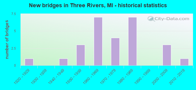
- New bridges - historical statistics
- 11920-1929
- 11940-1949
- 31950-1959
- 71960-1969
- 41970-1979
- 71980-1989
- 32000-2009
- 12010-2019
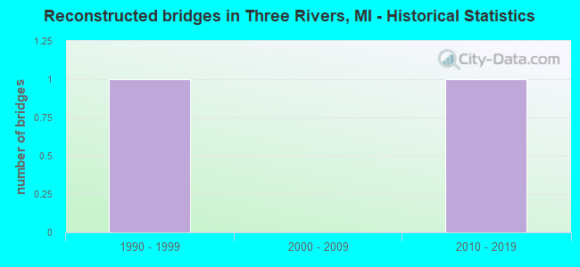
- Reconstructed bridges - Historical Statistics
- 11990-1999
- 02000-2009
- 12010-2019
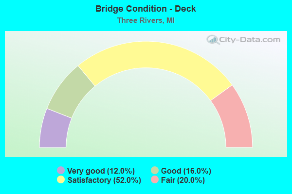
- Bridge Condition - Deck
- 12.0%Very good
- 16.0%Good
- 52.0%Satisfactory
- 20.0%Fair
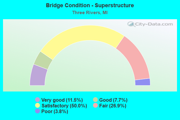
- Bridge Condition - Superstructure
- 11.5%Very good
- 7.7%Good
- 50.0%Satisfactory
- 26.9%Fair
- 3.8%Poor
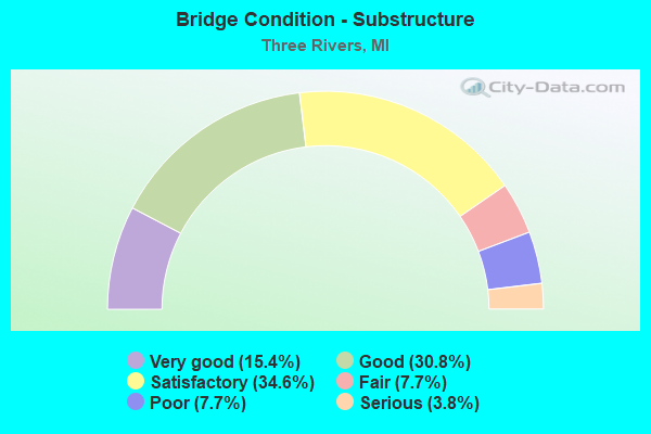
- Bridge Condition - Substructure
- 15.4%Very good
- 30.8%Good
- 34.6%Satisfactory
- 7.7%Fair
- 7.7%Poor
- 3.8%Serious
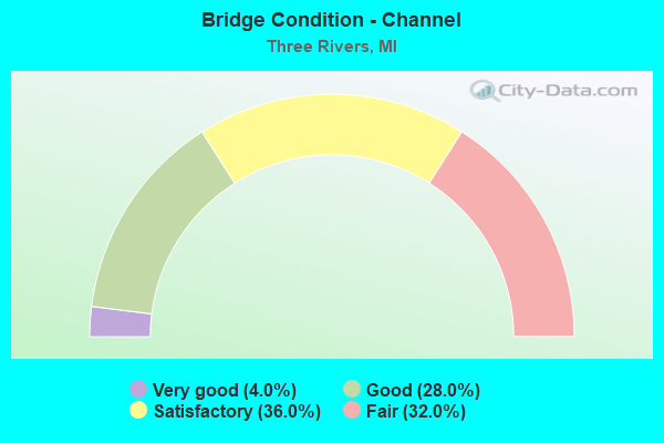
- Bridge Condition - Channel
- 4.0%Very good
- 28.0%Good
- 36.0%Satisfactory
- 32.0%Fair
Find on map >> Show street view
Structure Number: 1027, Location: 2 MI NE OF SODUS (Lat: 42.057903, Lng: -86.354733), Route carried "on" structure: County highway , Year Built: 2002, Status: Open, Structure Length: 1.16m (3.81ft), Average Daily Traffic: 381 (year 2007), Truck Traffic: 4%, Average Future Daily Traffic: 550 (year 2027), Design Load: HS 20, Features Intersected: PIPESTONE CREEK, Facility Carried by Structure: WATSON ROAD
Minimum Vertical Clearance: 30.48m (100.00ft), Kilometerpoint: 1.357, Lanes on structure: 2, Owner: County Highway Agency, Approaching Roadway Width: 6.7m (22.0ft), Skew: 1 degrees, Material/Design: Prestressed concrete, Design/Construction: Box Beam or Girders - Multiple, Number Of Spans In Main Unit: 1, Length of Maximum Span: 11.3m (37.1ft), Curb-To-Curb Width: 9.8m (32.2ft), Out-to-Out Width: 10.7m (35.1ft)
Condition: Deck: Very good, Superstructure: Very good, Substructure: Good, Channel: Good, Operating Rating: 83.9 metric tons, Method Used To Determine Operating Rating: Load Factor (LF) rating reported by rating factor (RF) method using MS18 loading, Inventory Rating: 50.2 metric tons, Method Used To Determine Inventory Rating: Load Factor (LF) rating reported by rating factor (RF) method using MS18 loading, Structural Evaluation: Better than present minimum criteria, Deck Geometry: Better than present minimum criteria, Waterway Adequacy: Superior to present desirable criteria, Approach Roadway Alignment: Equal to present minimum criteria, Designated Inspection Frequency: Every 24 months, Inspection Date: July 2020, Deck Structure Type: Concrete Cast-file-Place, Wearing Surface/Protective System: Wearing Surface: Monolithic Concrete
Find on map >> Show street view
Structure Number: 1039, Location: 0.5 MI S OF NEW TROY (Lat: 41.870783, Lng: -86.543603), Route carried "on" structure: County highway , Year Built: 1959, Status: Posted for load, Structure Length: 1.09m (3.58ft), Average Daily Traffic: 212 (year 2007), Truck Traffic: 4%, Average Future Daily Traffic: 300 (year 2027), Design Load: H 20, Features Intersected: EAST BRANCH GALIEN RIVER, Facility Carried by Structure: LOG CABIN ROAD
Minimum Vertical Clearance: 30.48m (100.00ft), Kilometerpoint: 3.274, Lanes on structure: 2, Owner: County Highway Agency, Approaching Roadway Width: 8.5m (27.9ft), Material/Design: Wood or Timber, Design/Construction: Stringer/Multi-beam, Number Of Spans In Main Unit: 1, Length of Maximum Span: 10.6m (34.8ft), Curb or Sidewalk Widths: Left: 0.9m (3.0ft), Right: 0.9m (3.0ft), Curb-To-Curb Width: 7.3m (24.0ft), Out-to-Out Width: 9.2m (30.2ft)
Condition: Deck: Fair, Superstructure: Satisfactory, Substructure: Poor, Channel: Satisfactory, Operating Rating: 14.9 metric tons, Method Used To Determine Operating Rating: Allowable Stress (AS) rating reported by rating factor (RF) method using MS18 loading, Inventory Rating: 6.5 metric tons, Method Used To Determine Inventory Rating: Allowable Stress (AS) rating reported by rating factor (RF) method using MS18 loading, Structural Evaluation: High priority of corrective action, Deck Geometry: Somewhat better than minimum adequacy, Waterway Adequacy: Equal to present desirable criteria, Approach Roadway Alignment: Equal to present desirable criteria, Bridge Posting: Required (Relationship of Operating Rating to Maximum Legal Load: > 39.9% below), Designated Inspection Frequency: Every 12 months, Inspection Date: April 2021, Deck Structure Type: Concrete Cast-file-Place, Wearing Surface/Protective System: Wearing Surface: Monolithic Concrete
Find on map >> Show street view
Structure Number: 10264, Location: 0.3 MI W OF THREE RIVERS (Lat: 41.954997, Lng: -85.645997), Route carried "on" structure: US 131, Year Built: 1951, Status: Open, Structure Length: 2.74m (8.99ft), Average Daily Traffic: 9,588 (year 2017), Truck Traffic: 8%, Average Future Daily Traffic: 10,588 (year 2037), Design Load: HS 20, Features Intersected: ROCKY RIVER
Minimum Vertical Clearance: 30.48m (100.00ft), Kilometerpoint: 12.639, Lanes on structure: 2, Base Highway Network: Yes (Inventory Route: 23, Subroute: 2), Owner: State Highway Agency, Approaching Roadway Width: 11.1m (36.4ft), Material/Design: Steel, Design/Construction: Stringer/Multi-beam, Number Of Spans In Main Unit: 2, Length of Maximum Span: 13.7m (44.9ft), Curb-To-Curb Width: 13.0m (42.7ft), Out-to-Out Width: 14.6m (47.9ft)
Condition: Deck: Fair, Superstructure: Satisfactory, Substructure: Good, Channel: Fair, Operating Rating: 71.6 metric tons, Method Used To Determine Operating Rating: Load Factor (LF) rating reported by rating factor (RF) method using MS18 loading, Inventory Rating: 42.8 metric tons, Method Used To Determine Inventory Rating: Load Factor (LF) rating reported by rating factor (RF) method using MS18 loading, Structural Evaluation: Equal to present minimum criteria, Deck Geometry: Superior to present desirable criteria, Waterway Adequacy: Equal to present desirable criteria, Approach Roadway Alignment: Better than present minimum criteria, Designated Inspection Frequency: Every 24 months, Inspection Date: July 2021, Deck Structure Type: Concrete Cast-file-Place, Wearing Surface/Protective System: Wearing Surface: Latex Concrete, Deck Protection: Epoxy Coated Reinforcing
Find on map >> Show street view
Structure Number: 10265, Location: 0.3 MI W OF THREE RIVERS (Lat: 41.955053, Lng: -85.646147), Route carried "on" structure: US 131, Year Built: 1956, Status: Open, Structure Length: 2.74m (8.99ft), Average Daily Traffic: 9,588 (year 2017), Truck Traffic: 8%, Average Future Daily Traffic: 10,588 (year 2037), Design Load: HS 20, Features Intersected: ROCKY RIVER
Minimum Vertical Clearance: 30.48m (100.00ft), Kilometerpoint: 3.819, Lanes on structure: 3, Base Highway Network: Yes (Inventory Route: 191, Subroute: 6), Owner: State Highway Agency, Approaching Roadway Width: 11.1m (36.4ft), Material/Design: Prestressed concrete, Design/Construction: Box Beam or Girders - Multiple, Number Of Spans In Main Unit: 2, Length of Maximum Span: 13.7m (44.9ft), Curb-To-Curb Width: 14.1m (46.3ft), Out-to-Out Width: 15.1m (49.5ft)
Condition: Deck: Good, Superstructure: Fair, Substructure: Good, Channel: Fair, Operating Rating: 39.9 metric tons, Method Used To Determine Operating Rating: Load and Resistance Factor Rating (LRFR) rating reported by rating factor(RF) method using HL-93 loadings, Inventory Rating: 25.3 metric tons, Method Used To Determine Inventory Rating: Load and Resistance Factor Rating (LRFR) rating reported by rating factor(RF) method using HL-93 loadings, Structural Evaluation: Somewhat better than minimum adequacy, Deck Geometry: Somewhat better than minimum adequacy, Waterway Adequacy: Equal to present desirable criteria, Approach Roadway Alignment: Equal to present desirable criteria, Designated Inspection Frequency: Every 24 months, Inspection Date: July 2021, Deck Structure Type: Concrete Cast-file-Place, Wearing Surface/Protective System: Wearing Surface: Epoxy Overlay
Find on map >> Show street view
Structure Number: 1027, Location: IN THREE RIVERS (Lat: 41.943094, Lng: -85.634656), Route carried "on" structure: State highway 60, Year Built: 1966, Status: Open, Structure Length: 1.40m (4.59ft), Average Daily Traffic: 9,299 (year 2007), Truck Traffic: 6%, Average Future Daily Traffic: 14,893 (year 2018), Design Load: HS 20, Features Intersected: ROCKY RIVER
Minimum Vertical Clearance: 30.48m (100.00ft), Kilometerpoint: 1.481, Lanes on structure: 4, Owner: State Highway Agency, Approaching Roadway Width: 15.2m (49.9ft), Material/Design: Steel, Design/Construction: Stringer/Multi-beam, Number Of Spans In Main Unit: 1, Length of Maximum Span: 14.0m (45.9ft), Curb or Sidewalk Widths: Left: 1.6m (5.2ft), Right: 1.6m (5.2ft), Curb-To-Curb Width: 15.2m (49.9ft), Out-to-Out Width: 19.0m (62.3ft)
Condition: Deck: Satisfactory, Superstructure: Satisfactory, Substructure: Good, Channel: Fair, Operating Rating: 62.2 metric tons, Method Used To Determine Operating Rating: Load Factor (LF) rating reported by rating factor (RF) method using MS18 loading, Inventory Rating: 37.3 metric tons, Method Used To Determine Inventory Rating: Load Factor (LF) rating reported by rating factor (RF) method using MS18 loading, Structural Evaluation: Equal to present minimum criteria, Deck Geometry: High priority of corrective action, Waterway Adequacy: Equal to present desirable criteria, Approach Roadway Alignment: Equal to present desirable criteria, Designated Inspection Frequency: Every 24 months, Inspection Date: September 2021, Deck Structure Type: Concrete Cast-file-Place, Wearing Surface/Protective System: Wearing Surface: Monolithic Concrete
Find on map >> Show street view
Structure Number: 10271, Location: IN THREE RIVERS(195 W MI) (Lat: 41.943328, Lng: -85.634011), Route carried "on" structure: State highway 60, Year Built: 1942, Status: Open, Structure Length: 1.09m (3.58ft), Average Daily Traffic: 9,299 (year 2007), Truck Traffic: 6%, Average Future Daily Traffic: 14,893 (year 2018), Design Load: H 20, Features Intersected: ROCKY RIVER RACE
Minimum Vertical Clearance: 30.48m (100.00ft), Kilometerpoint: 1.421, Lanes on structure: 4, Owner: State Highway Agency, Approaching Roadway Width: 15.5m (50.9ft), Material/Design: Concrete, Design/Construction: Tee Beam, Number Of Spans In Main Unit: 1, Length of Maximum Span: 10.9m (35.8ft), Curb or Sidewalk Widths: Left: 3.7m (12.1ft), Right: 3.7m (12.1ft), Curb-To-Curb Width: 15.2m (49.9ft), Out-to-Out Width: 22.9m (75.1ft)
Condition: Deck: Satisfactory, Superstructure: Fair, Substructure: Satisfactory, Channel: Fair, Operating Rating: 52.8 metric tons, Method Used To Determine Operating Rating: Load Factor (LF) rating reported by rating factor (RF) method using MS18 loading, Inventory Rating: 31.8 metric tons, Method Used To Determine Inventory Rating: Load Factor (LF) rating reported by rating factor (RF) method using MS18 loading, Structural Evaluation: Somewhat better than minimum adequacy, Deck Geometry: High priority of corrective action, Waterway Adequacy: Equal to present desirable criteria, Approach Roadway Alignment: Better than present minimum criteria, Designated Inspection Frequency: Every 24 months, Inspection Date: September 2021, Deck Structure Type: Concrete Cast-file-Place, Wearing Surface/Protective System: Wearing Surface: Bituminous
Find on map >> Show street view
Structure Number: 10272, Location: IN THREE RIVERS (E MICH) (Lat: 41.944422, Lng: -85.631331), Route carried "on" structure: State highway 60, Year Built: 1925, Status: Open, Structure Length: 1.70m (5.58ft), Average Daily Traffic: 4,978 (year 2007), Truck Traffic: 8%, Average Future Daily Traffic: 8,572 (year 2018), Design Load: H 15, Features Intersected: PORTAGE RIVER
Minimum Vertical Clearance: 30.48m (100.00ft), Kilometerpoint: 1.741, Lanes on structure: 2, Owner: State Highway Agency, Approaching Roadway Width: 14.0m (45.9ft), Material/Design: Concrete continuous, Design/Construction: Arch - Deck, Number Of Spans In Main Unit: 2, Length of Maximum Span: 8.5m (27.9ft), Curb or Sidewalk Widths: Left: 2.4m (7.9ft), Right: 2.4m (7.9ft), Curb-To-Curb Width: 14.0m (45.9ft), Out-to-Out Width: 20.1m (65.9ft)
Condition: Superstructure: Fair, Substructure: Satisfactory, Channel: Satisfactory, Operating Rating: 54.5 metric tons, Method Used To Determine Operating Rating: Field evaluation and documented engineering judgment, Inventory Rating: 32.7 metric tons, Method Used To Determine Inventory Rating: Field evaluation and documented engineering judgment, Structural Evaluation: Somewhat better than minimum adequacy, Deck Geometry: Superior to present desirable criteria, Waterway Adequacy: Equal to present desirable criteria, Approach Roadway Alignment: Equal to present desirable criteria, Designated Inspection Frequency: Every 24 months, Inspection Date: September 2021, Wearing Surface/Protective System: Wearing Surface: Bituminous
Find on map >> Show street view
Structure Number: 10281, Location: IN THREE RIVERS (Lat: 41.943011, Lng: -85.631883), Route carried "on" structure: State highway 86, Year Built: 2000, Status: Open, Structure Length: 5.53m (18.14ft), Average Daily Traffic: 6,441 (year 2007), Truck Traffic: 5%, Average Future Daily Traffic: 11,116 (year 2018), Design Load: HS 25 or greater, Features Intersected: ST JOSEPH RIVER
Minimum Vertical Clearance: 30.48m (100.00ft), Kilometerpoint: 0.084, Lanes on structure: 3, Owner: State Highway Agency, Approaching Roadway Width: 11.2m (36.7ft), Material/Design: Prestressed concrete, Design/Construction: Box Beam or Girders - Multiple, Number Of Spans In Main Unit: 3, Length of Maximum Span: 18.4m (60.4ft), Curb or Sidewalk Widths: Left: 2.4m (7.9ft), Right: 2.4m (7.9ft), Curb-To-Curb Width: 12.3m (40.4ft), Out-to-Out Width: 18.4m (60.4ft)
Condition: Deck: Satisfactory, Superstructure: Good, Substructure: Satisfactory, Channel: Satisfactory, Operating Rating: 89.4 metric tons, Method Used To Determine Operating Rating: Load Factor (LF) rating reported by rating factor (RF) method using MS18 loading, Inventory Rating: 36.6 metric tons, Method Used To Determine Inventory Rating: Load Factor (LF) rating reported by rating factor (RF) method using MS18 loading, Structural Evaluation: Equal to present minimum criteria, Deck Geometry: Meets minimum limits, Waterway Adequacy: Equal to present desirable criteria, Approach Roadway Alignment: Equal to present desirable criteria, Designated Inspection Frequency: Every 24 months, Underwater Inspection Frequency: Every 60 months, Inspection Date: July 2021, Underwater Inspection Date: August 2017, Deck Structure Type: Concrete Cast-file-Place, Wearing Surface/Protective System: Wearing Surface: Monolithic Concrete, Deck Protection: Epoxy Coated Reinforcing
Find on map >> Show street view
Structure Number: 10287, Location: 1.0 MI W OF US-131 (Lat: 42.027561, Lng: -85.652114), Route carried "on" structure: State highway 216, Year Built: 1989, Status: Open, Structure Length: 1.30m (4.27ft), Average Daily Traffic: 3,379 (year 2007), Truck Traffic: 7%, Average Future Daily Traffic: 5,479 (year 2018), Design Load: HS 25 or greater, Features Intersected: FLOWERFIELD CREEK
Minimum Vertical Clearance: 30.48m (100.00ft), Kilometerpoint: 9.225, Lanes on structure: 2, Owner: State Highway Agency, Approaching Roadway Width: 10.4m (34.1ft), Material/Design: Prestressed concrete, Design/Construction: Box Beam or Girders - Multiple, Number Of Spans In Main Unit: 1, Length of Maximum Span: 13.0m (42.7ft), Curb-To-Curb Width: 13.5m (44.3ft), Out-to-Out Width: 14.5m (47.6ft)
Condition: Deck: Good, Superstructure: Satisfactory, Substructure: Good, Channel: Fair, Operating Rating: 80.0 metric tons, Method Used To Determine Operating Rating: Load Factor (LF) rating reported by rating factor (RF) method using MS18 loading, Inventory Rating: 43.1 metric tons, Method Used To Determine Inventory Rating: Load Factor (LF) rating reported by rating factor (RF) method using MS18 loading, Structural Evaluation: Equal to present minimum criteria, Deck Geometry: Superior to present desirable criteria, Waterway Adequacy: Equal to present desirable criteria, Approach Roadway Alignment: Better than present minimum criteria, Designated Inspection Frequency: Every 24 months, Inspection Date: September 2021, Deck Structure Type: Concrete Cast-file-Place, Wearing Surface/Protective System: Wearing Surface: Monolithic Concrete, Deck Protection: Epoxy Coated Reinforcing
Find on map >> Show street view
Structure Number: 10293, Location: 1.5 MI NE OF THREE RIVERS (Lat: 41.976711, Lng: -85.601408), Route carried "on" structure: County highway , Year Built: 1969, Status: Posted for load, Structure Length: 2.92m (9.58ft), Average Daily Traffic: 1,311 (year 2003), Truck Traffic: 5%, Average Future Daily Traffic: 1,786 (year 2023), Design Load: HS 20, Features Intersected: PORTAGE RIVER, Facility Carried by Structure: S FISHER LAKE ROAD
Minimum Vertical Clearance: 30.48m (100.00ft), Kilometerpoint: 1.141, Lanes on structure: 2, Owner: County Highway Agency, Approaching Roadway Width: 10.1m (33.1ft), Material/Design: Wood or Timber, Design/Construction: Slab, Number Of Spans In Main Unit: 4, Length of Maximum Span: 7.3m (24.0ft), Curb-To-Curb Width: 9.1m (29.9ft), Out-to-Out Width: 9.7m (31.8ft)
Condition: Deck: Fair, Superstructure: Fair, Substructure: Serious, Channel: Fair, Operating Rating: 22.4 metric tons, Method Used To Determine Operating Rating: Allowable Stress (AS) rating reported by rating factor (RF) method using MS18 loading, Inventory Rating: 16.8 metric tons, Method Used To Determine Inventory Rating: Allowable Stress (AS) rating reported by rating factor (RF) method using MS18 loading, Structural Evaluation: High priority of corrective action, Deck Geometry: Somewhat better than minimum adequacy, Waterway Adequacy: Meets minimum limits, Approach Roadway Alignment: Equal to present desirable criteria, Bridge Posting: Required (Relationship of Operating Rating to Maximum Legal Load: 30.0 - 39.9% below), Designated Inspection Frequency: Every 12 months, Inspection Date: November 2021, Deck Structure Type: Wood or Timber, Wearing Surface/Protective System: Wearing Surface: Bituminous
Find on map >> Show street view
Structure Number: 10297, Location: SW OF MOOREPARK (Lat: 42.005700, Lng: -85.646139), Route carried "on" structure: County highway , Year Built: 2014, Status: Open, Structure Length: 2.74m (8.99ft), Average Daily Traffic: 419 (year 2014), Truck Traffic: 6%, Average Future Daily Traffic: 511 (year 2034), Design Load: Greater than HL93, Features Intersected: ROCKY RIVER, Facility Carried by Structure: FLOATING BRIDGE RD
Minimum Vertical Clearance: 30.48m (100.00ft), Kilometerpoint: 4.923, Lanes on structure: 2, Owner: County Highway Agency, Approaching Roadway Width: 9.8m (32.2ft), Material/Design: Prestressed concrete, Design/Construction: Box Beam or Girders - Multiple, Number Of Spans In Main Unit: 1, Length of Maximum Span: 27.0m (88.6ft), Curb-To-Curb Width: 9.8m (32.2ft), Out-to-Out Width: 10.6m (34.8ft)
Condition: Deck: Very good, Superstructure: Very good, Substructure: Very good, Channel: Good, Operating Rating: 90.1 metric tons, Method Used To Determine Operating Rating: Load and Resistance Factor Rating (LRFR) rating reported by rating factor(RF) method using HL-93 loadings, Inventory Rating: 60.6 metric tons, Method Used To Determine Inventory Rating: Load and Resistance Factor Rating (LRFR) rating reported by rating factor(RF) method using HL-93 loadings, Structural Evaluation: Equal to present desirable criteria, Deck Geometry: Equal to present minimum criteria, Waterway Adequacy: Equal to present desirable criteria, Approach Roadway Alignment: Somewhat better than minimum adequacy, Designated Inspection Frequency: Every 24 months, Inspection Date: November 2021, Deck Structure Type: Concrete Cast-file-Place, Wearing Surface/Protective System: Wearing Surface: Monolithic Concrete, Deck Protection: Epoxy Coated Reinforcing
Find on map >> Show street view
Structure Number: 1031, Location: 3 MI EAST OF THREE RIVERS (Lat: 41.965017, Lng: -85.569192), Route carried "on" structure: County highway 7835, Year Built: 1977, Status: Posted for load, Structure Length: 7.68m (25.20ft), Average Daily Traffic: 1,060 (year 2016), Truck Traffic: 10%, Average Future Daily Traffic: 1,171 (year 2036), Design Load: HS 20, Features Intersected: ST JOSEPH RIVER, Facility Carried by Structure: SCHWEITZER ROAD
Minimum Vertical Clearance: 30.48m (100.00ft), Kilometerpoint: 0.066, Lanes on structure: 2, Owner: County Highway Agency, Approaching Roadway Width: 8.7m (28.5ft), Skew: 1 degrees, Material/Design: Prestressed concrete, Design/Construction: Box Beam or Girders - Multiple, Number Of Spans In Main Unit: 4, Length of Maximum Span: 19.2m (63.0ft), Curb-To-Curb Width: 8.7m (28.5ft), Out-to-Out Width: 9.3m (30.5ft)
Condition: Deck: Satisfactory, Superstructure: Fair, Substructure: Satisfactory, Channel: Fair, Operating Rating: 42.1 metric tons, Method Used To Determine Operating Rating: Load Factor (LF) rating reported by rating factor (RF) method using MS18 loading, Inventory Rating: 25.3 metric tons, Method Used To Determine Inventory Rating: Load Factor (LF) rating reported by rating factor (RF) method using MS18 loading, Structural Evaluation: Somewhat better than minimum adequacy, Deck Geometry: Somewhat better than minimum adequacy, Waterway Adequacy: Better than present minimum criteria, Approach Roadway Alignment: Equal to present minimum criteria, Bridge Posting: Required (Relationship of Operating Rating to Maximum Legal Load: 10.0 - 19.9% below), Designated Inspection Frequency: Every 24 months, Underwater Inspection Frequency: Every 60 months, Inspection Date: November 2021, Underwater Inspection Date: May 2018, Deck Structure Type: Concrete Precast Panels, Wearing Surface/Protective System: Wearing Surface: Bituminous
Find on map >> Show street view
Structure Number: 10326, Location: 4 MI N OF THREE RIVERS (Lat: 41.998503, Lng: -85.584939), Route carried "on" structure: County highway , Year Built: 1969, Status: Open, Structure Length: 2.19m (7.19ft), Average Daily Traffic: 1,211 (year 2003), Truck Traffic: 5%, Average Future Daily Traffic: 1,700 (year 2023), Design Load: HS 20, Features Intersected: PORTAGE RIVER, Facility Carried by Structure: HEIMBACH ROAD
Minimum Vertical Clearance: 30.48m (100.00ft), Kilometerpoint: 4.184, Lanes on structure: 2, Owner: County Highway Agency, Approaching Roadway Width: 9.1m (29.9ft), Material/Design: Wood or Timber, Design/Construction: Slab, Number Of Spans In Main Unit: 3, Length of Maximum Span: 7.3m (24.0ft), Curb-To-Curb Width: 10.1m (33.1ft), Out-to-Out Width: 10.1m (33.1ft)
Condition: Deck: Satisfactory, Superstructure: Satisfactory, Substructure: Fair, Channel: Satisfactory, Operating Rating: 47.7 metric tons, Method Used To Determine Operating Rating: Allowable Stress (AS), Inventory Rating: 34.2 metric tons, Method Used To Determine Inventory Rating: Allowable Stress (AS), Structural Evaluation: Somewhat better than minimum adequacy, Deck Geometry: Somewhat better than minimum adequacy, Waterway Adequacy: Better than present minimum criteria, Approach Roadway Alignment: Equal to present desirable criteria, Designated Inspection Frequency: Every 24 months, Inspection Date: November 2021, Deck Structure Type: Wood or Timber, Wearing Surface/Protective System: Wearing Surface: Bituminous
Find on map >> Show street view
Structure Number: 1034, Location: 0.75 MI E OF US-131 (Lat: 41.889286, Lng: -85.648214), Route carried "on" structure: County highway , Year Built: 1979, Status: Open, Structure Length: 7.37m (24.18ft), Average Daily Traffic: 540 (year 2002), Truck Traffic: 7%, Average Future Daily Traffic: 798 (year 2023), Design Load: HS 20, Features Intersected: ST JOSEPH RIVER, Facility Carried by Structure: WITHERS ROAD
Minimum Vertical Clearance: 30.48m (100.00ft), Kilometerpoint: 1.270, Lanes on structure: 2, Owner: County Highway Agency, Approaching Roadway Width: 9.1m (29.9ft), Material/Design: Prestressed concrete, Design/Construction: Box Beam or Girders - Multiple, Number Of Spans In Main Unit: 4, Length of Maximum Span: 18.6m (61.0ft), Curb-To-Curb Width: 9.1m (29.9ft), Out-to-Out Width: 9.2m (30.2ft)
Condition: Deck: Satisfactory, Superstructure: Satisfactory, Substructure: Good, Channel: Very good, Operating Rating: 61.3 metric tons, Method Used To Determine Operating Rating: Load Factor (LF), Inventory Rating: 36.7 metric tons, Method Used To Determine Inventory Rating: Load Factor (LF), Structural Evaluation: Equal to present minimum criteria, Deck Geometry: Equal to present minimum criteria, Waterway Adequacy: Equal to present desirable criteria, Approach Roadway Alignment: Equal to present minimum criteria, Designated Inspection Frequency: Every 24 months, Underwater Inspection Frequency: Every 60 months, Inspection Date: November 2021, Underwater Inspection Date: May 2018, Deck Structure Type: Concrete Precast Panels, Wearing Surface/Protective System: Wearing Surface: Bituminous, Membrane: Preformed Fabric
Find on map >> Show street view
Structure Number: 10355, Location: 2 MI N OF THREE RIVERS (Lat: 41.983783, Lng: -85.647914), Route carried "on" structure: County highway , Year Built: 1966, Status: Open, Structure Length: 1.58m (5.18ft), Average Daily Traffic: 506 (year 2003), Truck Traffic: 5%, Average Future Daily Traffic: 740 (year 2023), Design Load: H 20, Features Intersected: ROCKY RIVER, Facility Carried by Structure: NULL ROAD
Minimum Vertical Clearance: 30.48m (100.00ft), Kilometerpoint: 1.323, Lanes on structure: 2, Owner: County Highway Agency, Approaching Roadway Width: 9.1m (29.9ft), Material/Design: Wood or Timber, Design/Construction: Slab, Number Of Spans In Main Unit: 2, Length of Maximum Span: 7.9m (25.9ft), Curb-To-Curb Width: 9.1m (29.9ft), Out-to-Out Width: 9.3m (30.5ft)
Condition: Deck: Satisfactory, Superstructure: Satisfactory, Substructure: Satisfactory, Channel: Good, Operating Rating: 44.8 metric tons, Method Used To Determine Operating Rating: Allowable Stress (AS), Inventory Rating: 32.0 metric tons, Method Used To Determine Inventory Rating: Allowable Stress (AS), Structural Evaluation: Equal to present minimum criteria, Deck Geometry: Equal to present minimum criteria, Waterway Adequacy: Equal to present minimum criteria, Approach Roadway Alignment: Equal to present desirable criteria, Designated Inspection Frequency: Every 24 months, Inspection Date: November 2021, Deck Structure Type: Wood or Timber, Wearing Surface/Protective System: Wearing Surface: Bituminous
Find on map >> Show street view
Structure Number: 10358, Location: 2 MI S OF THREE RIVERS (Lat: 41.909417, Lng: -85.639261), Route carried "on" structure: County highway , Year Built: 1972, Status: Open, Structure Length: 7.31m (23.98ft), Average Daily Traffic: 1,493 (year 2003), Truck Traffic: 5%, Average Future Daily Traffic: 2,008 (year 2023), Design Load: H 20, Features Intersected: ST JOSEPH RIVER, Facility Carried by Structure: CONSTANTINE STREET
Minimum Vertical Clearance: 30.48m (100.00ft), Kilometerpoint: 16.071, Lanes on structure: 2, Owner: County Highway Agency, Approaching Roadway Width: 7.9m (25.9ft), Skew: 1 degrees, Material/Design: Wood or Timber, Design/Construction: Slab, Number Of Spans In Main Unit: 12, Length of Maximum Span: 6.1m (20.0ft), Curb-To-Curb Width: 9.1m (29.9ft), Out-to-Out Width: 9.7m (31.8ft)
Condition: Deck: Fair, Superstructure: Fair, Substructure: Poor, Channel: Satisfactory, Operating Rating: 39.9 metric tons, Method Used To Determine Operating Rating: Allowable Stress (AS) rating reported by rating factor (RF) method using MS18 loading, Inventory Rating: 28.5 metric tons, Method Used To Determine Inventory Rating: Allowable Stress (AS) rating reported by rating factor (RF) method using MS18 loading, Structural Evaluation: Meets minimum limits, Deck Geometry: Somewhat better than minimum adequacy, Waterway Adequacy: Equal to present minimum criteria, Approach Roadway Alignment: Meets minimum limits, Designated Inspection Frequency: Every 12 months, Underwater Inspection Frequency: Every 60 months, Inspection Date: November 2021, Underwater Inspection Date: May 2018, Deck Structure Type: Wood or Timber, Wearing Surface/Protective System: Wearing Surface: Bituminous
Find on map >> Show street view
Structure Number: 10359, Location: 2 MI SE OF THREE RIVERS (Lat: 41.903031, Lng: -85.590536), Route carried "on" structure: County highway , Year Built: 2001, Status: Open, Structure Length: 3.81m (12.50ft), Average Daily Traffic: 165 (year 1997), Truck Traffic: 5%, Average Future Daily Traffic: 245 (year 2017), Design Load: HS 20, Features Intersected: PRAIRIE RIVER, Facility Carried by Structure: NEAMAN ROAD
Minimum Vertical Clearance: 30.48m (100.00ft), Kilometerpoint: 0.761, Lanes on structure: 2, Owner: County Highway Agency, Approaching Roadway Width: 9.1m (29.9ft), Material/Design: Prestressed concrete, Design/Construction: Box Beam or Girders - Multiple, Number Of Spans In Main Unit: 2, Length of Maximum Span: 19.0m (62.3ft), Curb-To-Curb Width: 9.1m (29.9ft), Out-to-Out Width: 9.6m (31.5ft)
Condition: Deck: Good, Superstructure: Good, Substructure: Very good, Channel: Good, Operating Rating: 61.6 metric tons, Method Used To Determine Operating Rating: Load Factor (LF), Inventory Rating: 36.9 metric tons, Method Used To Determine Inventory Rating: Load Factor (LF), Structural Evaluation: Better than present minimum criteria, Waterway Adequacy: Equal to present minimum criteria, Approach Roadway Alignment: Equal to present desirable criteria, Designated Inspection Frequency: Every 24 months, Inspection Date: November 2021, Deck Structure Type: Concrete Precast Panels, Wearing Surface/Protective System: Wearing Surface: Bituminous, Membrane: Preformed Fabric
Find on map >> Show street view
Structure Number: 1036, Location: 2 MI NE OF THREE RIVERS (Lat: 41.980800, Lng: -85.596236), Route carried "on" structure: County highway , Year Built: 1985, Status: Open, Structure Length: 2.68m (8.79ft), Average Daily Traffic: 80 (year 2003), Truck Traffic: 5%, Average Future Daily Traffic: 119 (year 2023), Design Load: H 20, Features Intersected: PORTAGE RIVER, Facility Carried by Structure: CARPENTER ROAD
Minimum Vertical Clearance: 30.48m (100.00ft), Kilometerpoint: 0.478, Lanes on structure: 2, Owner: County Highway Agency, Approaching Roadway Width: 9.1m (29.9ft), Material/Design: Wood or Timber, Design/Construction: Slab, Number Of Spans In Main Unit: 4, Length of Maximum Span: 6.7m (22.0ft), Curb-To-Curb Width: 9.1m (29.9ft), Out-to-Out Width: 9.5m (31.2ft)
Condition: Deck: Satisfactory, Superstructure: Satisfactory, Substructure: Satisfactory, Channel: Satisfactory, Operating Rating: 52.3 metric tons, Method Used To Determine Operating Rating: Allowable Stress (AS), Inventory Rating: 37.8 metric tons, Method Used To Determine Inventory Rating: Allowable Stress (AS), Structural Evaluation: Equal to present minimum criteria, Deck Geometry: Better than present minimum criteria, Waterway Adequacy: Equal to present minimum criteria, Approach Roadway Alignment: Equal to present desirable criteria, Designated Inspection Frequency: Every 24 months, Inspection Date: November 2021, Deck Structure Type: Wood or Timber, Wearing Surface/Protective System: Wearing Surface: Bituminous
Find on map >> Show street view
Structure Number: 10376, Location: 5 MI NE OF THREE RIVERS (Lat: 42.008053, Lng: -85.567217), Route carried "on" structure: County highway , Year Built: 1986, Status: Open, Structure Length: 6.09m (19.98ft), Average Daily Traffic: 341 (year 2003), Truck Traffic: 5%, Average Future Daily Traffic: 460 (year 2023), Design Load: HS 20, Features Intersected: PORTAGE RIVER, Facility Carried by Structure: N FISHER LAKE RD
Minimum Vertical Clearance: 30.48m (100.00ft), Kilometerpoint: 2.221, Lanes on structure: 2, Owner: County Highway Agency, Approaching Roadway Width: 9.1m (29.9ft), Skew: 3 degrees, Material/Design: Prestressed concrete, Design/Construction: Box Beam or Girders - Multiple, Number Of Spans In Main Unit: 4, Length of Maximum Span: 15.2m (49.9ft), Curb-To-Curb Width: 9.1m (29.9ft), Out-to-Out Width: 9.4m (30.8ft)
Condition: Deck: Good, Superstructure: Satisfactory, Substructure: Good, Channel: Good, Operating Rating: 65.8 metric tons, Method Used To Determine Operating Rating: Load Factor (LF), Inventory Rating: 39.4 metric tons, Method Used To Determine Inventory Rating: Load Factor (LF), Structural Evaluation: Equal to present minimum criteria, Deck Geometry: Equal to present minimum criteria, Waterway Adequacy: Equal to present desirable criteria, Approach Roadway Alignment: Equal to present minimum criteria, Designated Inspection Frequency: Every 24 months, Inspection Date: November 2021, Deck Structure Type: Other, Wearing Surface/Protective System: Wearing Surface: Bituminous, Membrane: Preformed Fabric, Deck Protection: Epoxy Coated Reinforcing
Find on map >> Show street view
Structure Number: 1039, Location: 0.2 MI EAST OF US-131 (Lat: 41.933089, Lng: -85.635725), Route carried "on" structure: Business City street 2043, Year Built: 1968, Year Reconstructed: 1990, Status: Posted for load, Structure Length: 7.50m (24.61ft), Average Daily Traffic: 4,900 (year 1991), Truck Traffic: 10%, Average Future Daily Traffic: 7,000 (year 2018), Design Load: HS 20+Mod, Features Intersected: ST JOSEPH RIVER, Facility Carried by Structure: BROADWAY STREET
Minimum Vertical Clearance: 30.48m (100.00ft), Kilometerpoint: 7.212, Lanes on structure: 2, Owner: City or Municipal Highway Agency, Approaching Roadway Width: 9.1m (29.9ft), Material/Design: Steel, Design/Construction: Stringer/Multi-beam, Number Of Spans In Main Unit: 3, Length of Maximum Span: 27.4m (89.9ft), Curb or Sidewalk Widths: Left: 1.8m (5.9ft), Right: 0.0m, Curb-To-Curb Width: 7.3m (24.0ft), Out-to-Out Width: 11.5m (37.7ft)
Condition: Deck: Satisfactory, Superstructure: Satisfactory, Substructure: Satisfactory, Channel: Satisfactory, Operating Rating: 54.1 metric tons, Method Used To Determine Operating Rating: Load and Resistance Factor Rating (LRFR) rating reported by rating factor(RF) method using HL-93 loadings, Inventory Rating: 36.0 metric tons, Method Used To Determine Inventory Rating: Load and Resistance Factor Rating (LRFR) rating reported by rating factor(RF) method using HL-93 loadings, Structural Evaluation: Equal to present minimum criteria, Deck Geometry: High priority of replacement, Waterway Adequacy: Equal to present desirable criteria, Approach Roadway Alignment: Better than present minimum criteria, Bridge Posting: Required (Relationship of Operating Rating to Maximum Legal Load: 0.1 - 9.9% below), Designated Inspection Frequency: Every 24 months, Inspection Date: September 2020, Deck Structure Type: Concrete Cast-file-Place, Wearing Surface/Protective System: Wearing Surface: Monolithic Concrete, Deck Protection: Epoxy Coated Reinforcing
Find on map >> Show street view
Structure Number: 10391, Location: 0.3 MI EAST OF US-131 BR (Lat: 41.947089, Lng: -85.628375), Route carried "on" structure: City street 2043, Year Built: 1985, Status: Open, Structure Length: 2.34m (7.68ft), Average Daily Traffic: 2,800 (year 1988), Average Future Daily Traffic: 2,800 (year 2018), Design Load: HS 20+Mod, Features Intersected: PORTAGE RIVER, Facility Carried by Structure: FIFTH AVENUE
Minimum Vertical Clearance: 30.48m (100.00ft), Kilometerpoint: 0.354, Lanes on structure: 2, Owner: City or Municipal Highway Agency, Approaching Roadway Width: 8.5m (27.9ft), Material/Design: Prestressed concrete, Design/Construction: Box Beam or Girders - Multiple, Number Of Spans In Main Unit: 2, Length of Maximum Span: 11.8m (38.7ft), Curb or Sidewalk Widths: Left: 1.6m (5.2ft), Right: 1.6m (5.2ft), Curb-To-Curb Width: 8.5m (27.9ft), Out-to-Out Width: 12.6m (41.3ft)
Condition: Deck: Satisfactory, Superstructure: Satisfactory, Substructure: Very good, Channel: Good, Operating Rating: 36.9 metric tons, Method Used To Determine Operating Rating: Load and Resistance Factor Rating (LRFR) rating reported by rating factor(RF) method using HL-93 loadings, Inventory Rating: 21.1 metric tons, Method Used To Determine Inventory Rating: Load and Resistance Factor Rating (LRFR) rating reported by rating factor(RF) method using HL-93 loadings, Structural Evaluation: Somewhat better than minimum adequacy, Deck Geometry: Meets minimum limits, Waterway Adequacy: Equal to present desirable criteria, Approach Roadway Alignment: Equal to present desirable criteria, Designated Inspection Frequency: Every 24 months, Inspection Date: September 2020, Deck Structure Type: Concrete Cast-file-Place, Wearing Surface/Protective System: Wearing Surface: Bituminous, Membrane: Preformed Fabric, Deck Protection: Epoxy Coated Reinforcing
Find on map >> Show street view
Structure Number: 10392, Location: JCTN/ E HOFFMAN & WOOD ST (Lat: 41.954703, Lng: -85.624200), Route carried "on" structure: City street 2043, Year Built: 1976, Year Reconstructed: 2019, Status: Open, Structure Length: 2.80m (9.19ft), Average Daily Traffic: 4,000 (year 2018), Truck Traffic: 3%, Average Future Daily Traffic: 5,000 (year 2038), Design Load: Greater than HL93, Features Intersected: PORTAGE RIVER, Facility Carried by Structure: HOFFMAN STREET
Minimum Vertical Clearance: 30.48m (100.00ft), Kilometerpoint: 11.169, Lanes on structure: 2, Owner: City or Municipal Highway Agency, Approaching Roadway Width: 11.0m (36.1ft), Material/Design: Prestressed concrete, Design/Construction: Box Beam or Girders - Single/Spread, Number Of Spans In Main Unit: 3, Length of Maximum Span: 9.4m (30.8ft), Curb or Sidewalk Widths: Left: 0.0m, Right: 1.6m (5.2ft), Curb-To-Curb Width: 10.7m (35.1ft), Out-to-Out Width: 13.0m (42.7ft)
Condition: Deck: Very good, Superstructure: Very good, Substructure: Very good, Channel: Good, Operating Rating: 50.2 metric tons, Method Used To Determine Operating Rating: Load and Resistance Factor Rating (LRFR) rating reported by rating factor(RF) method using HL-93 loadings, Inventory Rating: 38.9 metric tons, Method Used To Determine Inventory Rating: Load and Resistance Factor Rating (LRFR) rating reported by rating factor(RF) method using HL-93 loadings, Structural Evaluation: Equal to present desirable criteria, Deck Geometry: Somewhat better than minimum adequacy, Waterway Adequacy: Equal to present desirable criteria, Approach Roadway Alignment: Equal to present desirable criteria, Length Of Structure Improvement: 2.81m (9.22ft), Designated Inspection Frequency: Every 24 months, Inspection Date: September 2020, Bridge Improvement Cost: $375,000, Roadway Improvement Cost: $65,000, Total Project Cost: $440,000, Deck Structure Type: Concrete Cast-file-Place, Wearing Surface/Protective System: Wearing Surface: Monolithic Concrete, Deck Protection: Epoxy Coated Reinforcing
Find on map >> Show street view
Structure Number: 10393, Location: 0.1 MI E OF US-131 (Lat: 41.954397, Lng: -85.643725), Route carried "on" structure: City street 2043, Year Built: 1960, Status: Open, Structure Length: 3.84m (12.60ft), Average Daily Traffic: 4,600 (year 1988), Truck Traffic: 3%, Average Future Daily Traffic: 5,000 (year 2018), Design Load: HS 20+Mod, Features Intersected: ROCKEY RIVER, Facility Carried by Structure: HOFFMAN STREET
Minimum Vertical Clearance: 30.48m (100.00ft), Kilometerpoint: 9.547, Lanes on structure: 2, Owner: City or Municipal Highway Agency, Approaching Roadway Width: 8.5m (27.9ft), Skew: 1 degrees, Material/Design: Prestressed concrete, Design/Construction: Box Beam or Girders - Multiple, Number Of Spans In Main Unit: 3, Length of Maximum Span: 12.8m (42.0ft), Curb or Sidewalk Widths: Left: 1.5m (4.9ft), Right: 0.0m, Curb-To-Curb Width: 8.5m (27.9ft), Out-to-Out Width: 10.8m (35.4ft)
Condition: Deck: Fair, Superstructure: Poor, Substructure: Fair, Channel: Satisfactory, Operating Rating: 34.3 metric tons, Method Used To Determine Operating Rating: Load and Resistance Factor Rating (LRFR) rating reported by rating factor(RF) method using HL-93 loadings, Inventory Rating: 26.6 metric tons, Method Used To Determine Inventory Rating: Load and Resistance Factor Rating (LRFR) rating reported by rating factor(RF) method using HL-93 loadings, Structural Evaluation: Meets minimum limits, Deck Geometry: Meets minimum limits, Waterway Adequacy: Equal to present desirable criteria, Approach Roadway Alignment: Superior to present desirable criteria, Bridge Posting: Required (Relationship of Operating Rating to Maximum Legal Load: 30.0 - 39.9% below), Length Of Structure Improvement: 3.84m (12.60ft), Designated Inspection Frequency: Every 12 months, Inspection Date: September 2021, Bridge Improvement Cost: $475,000, Roadway Improvement Cost: $60,000, Total Project Cost: $535,000, Deck Structure Type: Concrete Cast-file-Place, Wearing Surface/Protective System: Wearing Surface: Bituminous, Membrane: Preformed Fabric
Find on map >> Show street view
Structure Number: 10394, Location: 0.3 MI EAST OF US-131 (Lat: 41.940228, Lng: -85.627122), Route carried "on" structure: City street 2043, Year Built: 1965, Status: Open, Structure Length: 4.51m (14.80ft), Average Daily Traffic: 2,400 (year 1990), Average Future Daily Traffic: 2,500 (year 2018), Design Load: HS 20+Mod, Features Intersected: ST JOSEPH RIVER, Facility Carried by Structure: SIXTH STREET
Minimum Vertical Clearance: 30.48m (100.00ft), Kilometerpoint: 0.372, Lanes on structure: 2, Owner: City or Municipal Highway Agency, Approaching Roadway Width: 7.3m (24.0ft), Material/Design: Prestressed concrete, Design/Construction: Box Beam or Girders - Multiple, Number Of Spans In Main Unit: 3, Length of Maximum Span: 15.2m (49.9ft), Curb or Sidewalk Widths: Left: 0.0m, Right: 2.1m (6.9ft), Curb-To-Curb Width: 10.1m (33.1ft), Out-to-Out Width: 13.1m (43.0ft)
Condition: Deck: Satisfactory, Superstructure: Fair, Substructure: Satisfactory, Channel: Satisfactory, Operating Rating: 49.9 metric tons, Method Used To Determine Operating Rating: Load and Resistance Factor Rating (LRFR) rating reported by rating factor(RF) method using HL-93 loadings, Inventory Rating: 38.6 metric tons, Method Used To Determine Inventory Rating: Load and Resistance Factor Rating (LRFR) rating reported by rating factor(RF) method using HL-93 loadings, Structural Evaluation: Somewhat better than minimum adequacy, Deck Geometry: Meets minimum limits, Waterway Adequacy: Superior to present desirable criteria, Approach Roadway Alignment: Equal to present desirable criteria, Designated Inspection Frequency: Every 24 months, Inspection Date: September 2020, Deck Structure Type: Concrete Cast-file-Place, Wearing Surface/Protective System: Wearing Surface: Bituminous
Find on map >> Show street view
Structure Number: 10395, Location: TWO BLOCKS W OF MAIN ST (Lat: 41.945911, Lng: -85.637131), Route carried "on" structure: City street 2043, Year Built: 1981, Status: Open, Structure Length: 4.11m (13.48ft), Average Daily Traffic: 2,700 (year 1989), Average Future Daily Traffic: 2,700 (year 2018), Design Load: HS 20+Mod, Features Intersected: ROCKY RIVER, Facility Carried by Structure: PEALER STREET
Minimum Vertical Clearance: 30.48m (100.00ft), Kilometerpoint: 0.816, Lanes on structure: 2, Owner: City or Municipal Highway Agency, Approaching Roadway Width: 8.5m (27.9ft), Material/Design: Prestressed concrete, Design/Construction: Box Beam or Girders - Multiple, Number Of Spans In Main Unit: 3, Length of Maximum Span: 13.7m (44.9ft), Curb or Sidewalk Widths: Left: 2.0m (6.6ft), Right: 0.0m, Curb-To-Curb Width: 8.5m (27.9ft), Out-to-Out Width: 11.5m (37.7ft)
Condition: Deck: Satisfactory, Superstructure: Satisfactory, Substructure: Satisfactory, Channel: Fair, Operating Rating: 40.2 metric tons, Method Used To Determine Operating Rating: Load and Resistance Factor Rating (LRFR) rating reported by rating factor(RF) method using HL-93 loadings, Inventory Rating: 30.1 metric tons, Method Used To Determine Inventory Rating: Load and Resistance Factor Rating (LRFR) rating reported by rating factor(RF) method using HL-93 loadings, Structural Evaluation: Equal to present minimum criteria, Deck Geometry: Meets minimum limits, Waterway Adequacy: Equal to present desirable criteria, Approach Roadway Alignment: Equal to present desirable criteria, Designated Inspection Frequency: Every 24 months, Inspection Date: September 2020, Deck Structure Type: Concrete Cast-file-Place, Wearing Surface/Protective System: Wearing Surface: Bituminous, Membrane: Preformed Fabric, Deck Protection: Epoxy Coated Reinforcing
Find on map >> Show street view
Structure Number: 10396, Location: ONE BLOCK W OF MAIN ST (Lat: 41.946025, Lng: -85.635961), Route carried "on" structure: City street 2043, Year Built: 1981, Status: Open, Structure Length: 4.45m (14.60ft), Average Daily Traffic: 2,700 (year 1989), Average Future Daily Traffic: 2,700 (year 2018), Design Load: HS 20+Mod, Features Intersected: RAILROAD DR & CONRAIL RR, Facility Carried by Structure: PEALER STREET
Minimum Vertical Clearance: 30.48m (100.00ft), Kilometerpoint: 0.901, Lanes on structure: 2, Lanes under structure: 2, Owner: City or Municipal Highway Agency, Approaching Roadway Width: 8.5m (27.9ft), Skew: 3 degrees, Material/Design: Prestressed concrete, Design/Construction: Box Beam or Girders - Multiple, Number Of Spans In Main Unit: 3, Length of Maximum Span: 17.0m (55.8ft), Curb or Sidewalk Widths: Left: 2.0m (6.6ft), Right: 0.0m, Curb-To-Curb Width: 8.5m (27.9ft), Out-to-Out Width: 11.5m (37.7ft)
Condition: Deck: Satisfactory, Superstructure: Satisfactory, Substructure: Good, Operating Rating: 37.6 metric tons, Method Used To Determine Operating Rating: Load and Resistance Factor Rating (LRFR) rating reported by rating factor(RF) method using HL-93 loadings, Inventory Rating: 15.2 metric tons, Method Used To Determine Inventory Rating: Load and Resistance Factor Rating (LRFR) rating reported by rating factor(RF) method using HL-93 loadings, Structural Evaluation: Meets minimum limits, Deck Geometry: Meets minimum limits, Underclear: Superior to present desirable criteria, Approach Roadway Alignment: Equal to present desirable criteria, Designated Inspection Frequency: Every 24 months, Inspection Date: September 2020, Deck Structure Type: Concrete Cast-file-Place, Wearing Surface/Protective System: Wearing Surface: Bituminous, Membrane: Preformed Fabric, Deck Protection: Epoxy Coated Reinforcing
Find on map >> Show street view
Structure Number: 10396, Location: ONE BLOCK W OF MAIN ST (Lat: 41.946025, Lng: -85.635961), Route carried "under" structure: ServiceCity street , Year Built: 1981, Structure Length: 0. m, Average Daily Traffic: 350 (year 1985), Features Intersected: RAILROAD DR & CONRAIL RR, Facility Carried by Structure: PEALER STREET
Minimum Vertical Clearance: 8.84m (29.00ft), Kilometerpoint: 23.608, Lanes on structure: 2, Lanes under structure: 2, Material/Design: Prestressed concrete, Design/Construction: Box Beam or Girders - Multiple, Length of Maximum Span: 17.0m (55.8ft)