Bridge Statistics for Throckmorton, Texas (TX)
Condition, Traffic, Stress, Structural Evaluation, Project Costs
- National Bridge Inventory (NBI) Statistics
- 14Number of bridges
- 79ft / 24.1mTotal length
- 10,917Total average daily traffic
- 1,950Total average daily truck traffic
- 16,429Total future (year 2030) average daily traffic
- National Bridge Inventory (NBI) Registered Bridges for Throckmorton
- No street view available for this location
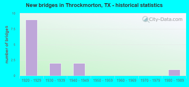
- New bridges - historical statistics
- 91920-1929
- 21930-1939
- 21940-1949
- 11980-1989
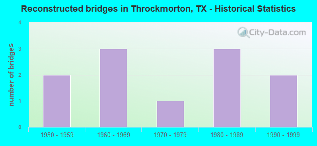
- Reconstructed bridges - Historical Statistics
- 21950-1959
- 31960-1969
- 11970-1979
- 31980-1989
- 21990-1999
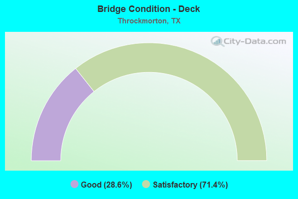
- Bridge Condition - Deck
- 28.6%Good
- 71.4%Satisfactory
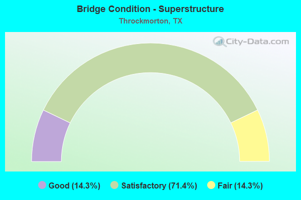
- Bridge Condition - Superstructure
- 14.3%Good
- 71.4%Satisfactory
- 14.3%Fair
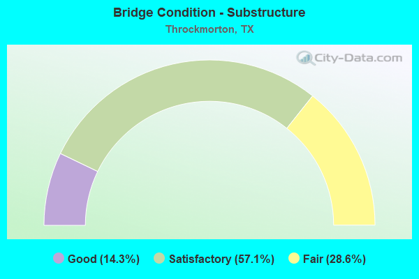
- Bridge Condition - Substructure
- 14.3%Good
- 57.1%Satisfactory
- 28.6%Fair
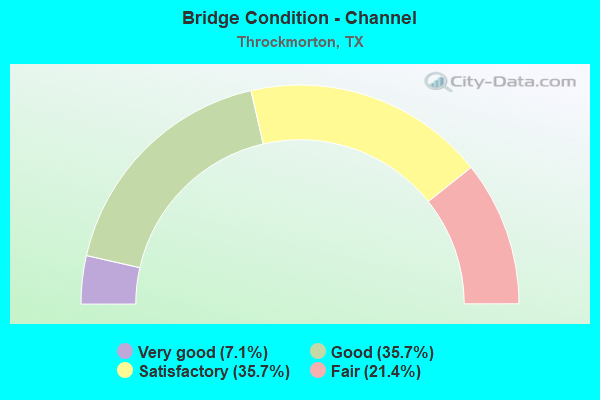
- Bridge Condition - Channel
- 7.1%Very good
- 35.7%Good
- 35.7%Satisfactory
- 21.4%Fair
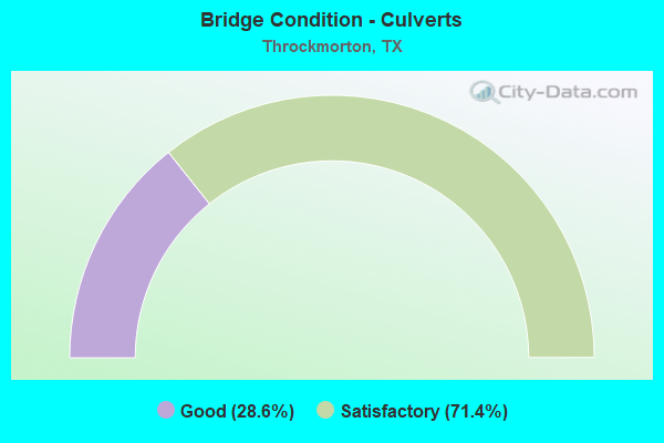
- Bridge Condition - Culverts
- 28.6%Good
- 71.4%Satisfactory
Find on map >> Show street view
Structure Number: 32240012502011, Location: 2.5 MI N OF SH 79 (Lat: 33.222231, Lng: -99.199311), Route carried "on" structure: US 183, Year Built: 1929, Year Reconstructed: 1989, Status: Open, Structure Length: 1.19m (3.90ft), Average Daily Traffic: 587 (year 2020), Truck Traffic: 23%, Average Future Daily Traffic: 869 (year 2040), Design Load: H 15, Features Intersected: COW CREEK
Minimum Vertical Clearance: 30+ m (98+ ft), Kilometerpoint: 19.618, Lanes on structure: 2, Base Highway Network: Yes, Owner: State Highway Agency, Approaching Roadway Width: 10.1m (33.1ft), Material/Design: Concrete, Design/Construction: Tee Beam, Number Of Spans In Main Unit: 1, Length of Maximum Span: 11.9m (39.0ft), Curb-To-Curb Width: 13.6m (44.6ft), Out-to-Out Width: 14.0m (45.9ft)
Condition: Deck: Good, Superstructure: Good, Substructure: Satisfactory, Channel: Satisfactory, Operating Rating: 50.8 metric tons, Method Used To Determine Operating Rating: Load Factor (LF), Inventory Rating: 29.9 metric tons, Method Used To Determine Inventory Rating: Load Factor (LF), Structural Evaluation: Equal to present minimum criteria, Deck Geometry: Superior to present desirable criteria, Waterway Adequacy: Superior to present desirable criteria, Approach Roadway Alignment: Equal to present minimum criteria, Designated Inspection Frequency: Every 24 months, Inspection Date: October 2021, Deck Structure Type: Concrete Cast-file-Place, Wearing Surface/Protective System: Wearing Surface: Bituminous
Find on map >> Show street view
Structure Number: 32240012502012, Location: 1.7 MI N OF SH 79 (Lat: 33.212233, Lng: -99.196042), Route carried "on" structure: US 183, Year Built: 1929, Year Reconstructed: 1987, Status: Open, Structure Length: 1.62m (5.31ft), Average Daily Traffic: 587 (year 2020), Truck Traffic: 23%, Average Future Daily Traffic: 869 (year 2040), Design Load: H 15, Features Intersected: HORSE CREEK
Minimum Vertical Clearance: 30+ m (98+ ft), Kilometerpoint: 20.846, Lanes on structure: 2, Owner: State Highway Agency, Approaching Roadway Width: 10.1m (33.1ft), Material/Design: Concrete, Design/Construction: Tee Beam, Number Of Spans In Main Unit: 2, Length of Maximum Span: 7.9m (25.9ft), Curb-To-Curb Width: 13.5m (44.3ft), Out-to-Out Width: 14.0m (45.9ft)
Condition: Deck: Satisfactory, Superstructure: Satisfactory, Substructure: Satisfactory, Channel: Satisfactory, Operating Rating: 68.0 metric tons, Method Used To Determine Operating Rating: Load Factor (LF), Inventory Rating: 40.8 metric tons, Method Used To Determine Inventory Rating: Load Factor (LF), Structural Evaluation: Equal to present minimum criteria, Deck Geometry: Superior to present desirable criteria, Waterway Adequacy: Superior to present desirable criteria, Approach Roadway Alignment: Equal to present desirable criteria, Designated Inspection Frequency: Every 24 months, Inspection Date: October 2021, Deck Structure Type: Concrete Cast-file-Place, Wearing Surface/Protective System: Wearing Surface: Bituminous
Find on map >> Show street view
Structure Number: 32240012502013, Location: 0.5 MI S OF SH 79 (Lat: 33.185164, Lng: -99.177339), Route carried "on" structure: US 183, Year Built: 1929, Year Reconstructed: 1970, Status: Open, Structure Length: 0.98m (3.22ft), Average Daily Traffic: 2,375 (year 2020), Truck Traffic: 10%, Average Future Daily Traffic: 2,811 (year 2038), Design Load: H 15, Features Intersected: DRAW
Minimum Vertical Clearance: 30+ m (98+ ft), Kilometerpoint: 24.552, Lanes on structure: 2, Base Highway Network: Yes, Owner: State Highway Agency, Approaching Roadway Width: 20.7m (67.9ft), Material/Design: Concrete, Design/Construction: Culvert, Number Of Spans In Main Unit: 9, Length of Maximum Span: 0.9m (3.0ft), Curb-To-Curb Width: 20.7m (67.9ft), Out-to-Out Width: 21.0m (68.9ft)
Condition: Channel: Fair, Culverts: Satisfactory, Operating Rating: 39.9 metric tons, Method Used To Determine Operating Rating: Load Factor (LF), Inventory Rating: 23.6 metric tons, Method Used To Determine Inventory Rating: Load Factor (LF), Structural Evaluation: Equal to present minimum criteria, Deck Geometry: Superior to present desirable criteria, Waterway Adequacy: Equal to present minimum criteria, Approach Roadway Alignment: Equal to present desirable criteria, Designated Inspection Frequency: Every 24 months, Inspection Date: October 2021, Deck Structure Type: Concrete Cast-file-Place, Wearing Surface/Protective System: Wearing Surface: Bituminous
Find on map >> Show street view
Structure Number: 32240012502026, Location: 2.8 MI N OF SH 79 (Lat: 33.226283, Lng: -99.198681), Route carried "on" structure: US 183, Year Built: 1988, Status: Open, Structure Length: 4.30m (14.11ft), Average Daily Traffic: 587 (year 2020), Truck Traffic: 35%, Average Future Daily Traffic: 869 (year 2040), Design Load: HS 20, Features Intersected: NORTH ELM CREEK
Minimum Vertical Clearance: 30+ m (98+ ft), Kilometerpoint: 19.143, Lanes on structure: 2, Base Highway Network: Yes, Owner: State Highway Agency, Approaching Roadway Width: 10.1m (33.1ft), Material/Design: Concrete, Design/Construction: Stringer/Multi-beam, Number Of Spans In Main Unit: 2, Number Of Approach Spans: 2, Length of Maximum Span: 12.2m (40.0ft), Curb-To-Curb Width: 13.6m (44.6ft), Out-to-Out Width: 14.1m (46.3ft)
Condition: Deck: Satisfactory, Superstructure: Satisfactory, Substructure: Good, Channel: Satisfactory, Operating Rating: 68.0 metric tons, Method Used To Determine Operating Rating: Load Factor (LF), Inventory Rating: 40.8 metric tons, Method Used To Determine Inventory Rating: Load Factor (LF), Structural Evaluation: Equal to present minimum criteria, Deck Geometry: Superior to present desirable criteria, Waterway Adequacy: Equal to present minimum criteria, Approach Roadway Alignment: Equal to present desirable criteria, Designated Inspection Frequency: Every 24 months, Inspection Date: October 2021, Deck Structure Type: Concrete Cast-file-Place, Wearing Surface/Protective System: Wearing Surface: Bituminous
Find on map >> Show street view
Structure Number: 32240012503014, Location: 0.2 MI S OF US 380 (Lat: 33.175783, Lng: -99.177378), Route carried "on" structure: US 183, Year Built: 1929, Year Reconstructed: 1987, Status: Open, Structure Length: 2.07m (6.79ft), Average Daily Traffic: 1,916 (year 2020), Truck Traffic: 21%, Average Future Daily Traffic: 2,390 (year 2037), Features Intersected: ELM CREEK
Minimum Vertical Clearance: 30+ m (98+ ft), Kilometerpoint: 25.619, Lanes on structure: 2, Base Highway Network: Yes, Owner: State Highway Agency, Approaching Roadway Width: 20.7m (67.9ft), Material/Design: Concrete continuous, Design/Construction: Slab, Number Of Spans In Main Unit: 4, Length of Maximum Span: 5.2m (17.1ft), Curb-To-Curb Width: 20.8m (68.2ft), Out-to-Out Width: 21.3m (69.9ft)
Condition: Deck: Satisfactory, Superstructure: Satisfactory, Substructure: Satisfactory, Channel: Good, Operating Rating: 53.5 metric tons, Method Used To Determine Operating Rating: Load Factor (LF), Inventory Rating: 31.7 metric tons, Method Used To Determine Inventory Rating: Load Factor (LF), Structural Evaluation: Equal to present minimum criteria, Deck Geometry: Superior to present desirable criteria, Waterway Adequacy: Superior to present desirable criteria, Approach Roadway Alignment: Equal to present desirable criteria, Designated Inspection Frequency: Every 24 months, Inspection Date: October 2021, Deck Structure Type: Concrete Cast-file-Place, Wearing Surface/Protective System: Wearing Surface: Bituminous
Find on map >> Show street view
Structure Number: 32240012503015, Location: 3.2 MI N OF FM 923 (Lat: 33.168667, Lng: -99.176178), Route carried "on" structure: US 183, Year Built: 1929, Year Reconstructed: 1961, Status: Open, Structure Length: 0.67m (2.20ft), Average Daily Traffic: 999 (year 2020), Truck Traffic: 27%, Average Future Daily Traffic: 1,976 (year 2038), Design Load: H 15, Features Intersected: DRAW
Minimum Vertical Clearance: 30+ m (98+ ft), Kilometerpoint: 26.414, Lanes on structure: 2, Owner: State Highway Agency, Approaching Roadway Width: 10.1m (33.1ft), Material/Design: Concrete, Design/Construction: Culvert, Number Of Spans In Main Unit: 4, Length of Maximum Span: 1.5m (4.9ft), Curb-To-Curb Width: 13.2m (43.3ft), Out-to-Out Width: 13.7m (44.9ft)
Condition: Channel: Good, Culverts: Satisfactory, Operating Rating: 39.9 metric tons, Method Used To Determine Operating Rating: Load Factor (LF), Inventory Rating: 23.6 metric tons, Method Used To Determine Inventory Rating: Load Factor (LF), Structural Evaluation: Equal to present minimum criteria, Deck Geometry: Superior to present desirable criteria, Waterway Adequacy: Equal to present minimum criteria, Approach Roadway Alignment: Equal to present desirable criteria, Designated Inspection Frequency: Every 24 months, Inspection Date: October 2021, Deck Structure Type: Concrete Cast-file-Place, Wearing Surface/Protective System: Wearing Surface: Bituminous
Find on map >> Show street view
Structure Number: 32240012503016, Location: 1.2 MI N OF FM 923 (Lat: 33.141319, Lng: -99.173906), Route carried "on" structure: US 183, Year Built: 1929, Year Reconstructed: 1961, Status: Open, Structure Length: 0.82m (2.69ft), Average Daily Traffic: 1,027 (year 2019), Truck Traffic: 29%, Average Future Daily Traffic: 1,190 (year 2038), Design Load: H 15, Features Intersected: DRAW
Minimum Vertical Clearance: 30+ m (98+ ft), Kilometerpoint: 29.691, Lanes on structure: 2, Base Highway Network: Yes, Owner: State Highway Agency, Approaching Roadway Width: 9.8m (32.2ft), Material/Design: Concrete, Design/Construction: Culvert, Number Of Spans In Main Unit: 4, Length of Maximum Span: 1.8m (5.9ft), Curb-To-Curb Width: 15.6m (51.2ft), Out-to-Out Width: 16.4m (53.8ft)
Condition: Channel: Good, Culverts: Satisfactory, Operating Rating: 39.9 metric tons, Method Used To Determine Operating Rating: Load Factor (LF), Inventory Rating: 23.6 metric tons, Method Used To Determine Inventory Rating: Load Factor (LF), Structural Evaluation: Equal to present minimum criteria, Deck Geometry: Superior to present desirable criteria, Waterway Adequacy: Equal to present minimum criteria, Approach Roadway Alignment: Equal to present desirable criteria, Designated Inspection Frequency: Every 24 months, Inspection Date: October 2021, Deck Structure Type: Concrete Cast-file-Place, Wearing Surface/Protective System: Wearing Surface: Bituminous
Find on map >> Show street view
Structure Number: 32240028402004, Location: 1.2 MI SW OF FM 2356 (Lat: 33.215219, Lng: -99.130147), Route carried "on" structure: State highway 79, Year Built: 1929, Year Reconstructed: 1971, Status: Open, Structure Length: 1.37m (4.49ft), Average Daily Traffic: 414 (year 2020), Truck Traffic: 3%, Average Future Daily Traffic: 1,060 (year 2037), Design Load: H 15, Features Intersected: DRAIN
Minimum Vertical Clearance: 30+ m (98+ ft), Kilometerpoint: 19.768, Lanes on structure: 2, Base Highway Network: Yes, Owner: State Highway Agency, Approaching Roadway Width: 7.3m (24.0ft), Material/Design: Concrete, Design/Construction: Culvert, Number Of Spans In Main Unit: 7, Length of Maximum Span: 1.8m (5.9ft), Curb-To-Curb Width: 7.3m (24.0ft), Out-to-Out Width: 26.2m (86.0ft)
Condition: Channel: Very good, Culverts: Satisfactory, Operating Rating: 39.9 metric tons, Method Used To Determine Operating Rating: Load Factor (LF), Inventory Rating: 23.6 metric tons, Method Used To Determine Inventory Rating: Load Factor (LF), Structural Evaluation: Equal to present minimum criteria, Deck Geometry: Meets minimum limits, Waterway Adequacy: Equal to present minimum criteria, Approach Roadway Alignment: Equal to present desirable criteria, Designated Inspection Frequency: Every 24 months, Inspection Date: October 2021, Deck Structure Type: Concrete Cast-file-Place, Wearing Surface/Protective System: Wearing Surface: Bituminous
Find on map >> Show street view
Structure Number: 32240028402005, Location: 1.5 MI NE OF US 283 (Lat: 33.204431, Lng: -99.155731), Route carried "on" structure: State highway 79, Year Built: 1929, Year Reconstructed: 1971, Status: Open, Structure Length: 2.83m (9.28ft), Average Daily Traffic: 414 (year 2020), Truck Traffic: 3%, Average Future Daily Traffic: 1,060 (year 2037), Design Load: H 15, Features Intersected: NORTH ELM CREEK
Minimum Vertical Clearance: 30+ m (98+ ft), Kilometerpoint: 22.441, Lanes on structure: 2, Base Highway Network: Yes, Owner: State Highway Agency, Approaching Roadway Width: 7.3m (24.0ft), Material/Design: Concrete, Design/Construction: Tee Beam, Number Of Spans In Main Unit: 3, Length of Maximum Span: 9.4m (30.8ft), Curb-To-Curb Width: 14.6m (47.9ft), Out-to-Out Width: 15.2m (49.9ft)
Condition: Deck: Good, Superstructure: Fair, Substructure: Satisfactory, Channel: Satisfactory, Operating Rating: 47.2 metric tons, Method Used To Determine Operating Rating: Load Factor (LF), Inventory Rating: 28.1 metric tons, Method Used To Determine Inventory Rating: Load Factor (LF), Structural Evaluation: Somewhat better than minimum adequacy, Deck Geometry: Superior to present desirable criteria, Waterway Adequacy: Equal to present minimum criteria, Approach Roadway Alignment: Equal to present desirable criteria, Designated Inspection Frequency: Every 24 months, Inspection Date: October 2021, Deck Structure Type: Concrete Cast-file-Place, Wearing Surface/Protective System: Wearing Surface: Bituminous
Find on map >> Show street view
Structure Number: 32240028402006, Location: 1.0 MI NE OF US 283 (Lat: 33.201819, Lng: -99.161872), Route carried "on" structure: State highway 79, Year Built: 1929, Year Reconstructed: 1971, Status: Open, Structure Length: 0.64m (2.10ft), Average Daily Traffic: 414 (year 2020), Truck Traffic: 6%, Average Future Daily Traffic: 770 (year 2038), Design Load: H 15, Features Intersected: DRAW
Minimum Vertical Clearance: 30+ m (98+ ft), Kilometerpoint: 23.078, Lanes on structure: 2, Owner: State Highway Agency, Approaching Roadway Width: 7.9m (25.9ft), Material/Design: Concrete, Design/Construction: Culvert, Number Of Spans In Main Unit: 6, Length of Maximum Span: 0.9m (3.0ft), Curb-To-Curb Width: 7.9m (25.9ft), Out-to-Out Width: 26.8m (87.9ft)
Condition: Channel: Good, Culverts: Good, Operating Rating: 32.7 metric tons, Method Used To Determine Operating Rating: Assigned ratings based on Allowable Stress Design (ASD) reported in metric tons, Inventory Rating: 24.5 metric tons, Method Used To Determine Inventory Rating: Assigned ratings based on Allowable Stress Design (ASD) reported in metric tons, Structural Evaluation: Equal to present minimum criteria, Deck Geometry: Somewhat better than minimum adequacy, Waterway Adequacy: Equal to present minimum criteria, Approach Roadway Alignment: Equal to present desirable criteria, Designated Inspection Frequency: Every 24 months, Inspection Date: October 2021, Deck Structure Type: Concrete Cast-file-Place, Wearing Surface/Protective System: Wearing Surface: Bituminous
Find on map >> Show street view
Structure Number: 32240036005014, Location: 2.5 MI W OF US 183/283 (Lat: 33.181322, Lng: -99.221875), Route carried "on" structure: US 380, Year Built: 1932, Year Reconstructed: 1996, Status: Open, Structure Length: 1.86m (6.10ft), Average Daily Traffic: 715 (year 2020), Truck Traffic: 15%, Average Future Daily Traffic: 1,387 (year 2038), Design Load: H 15, Features Intersected: HORSE CREEK
Minimum Vertical Clearance: 30+ m (98+ ft), Kilometerpoint: 24.935, Lanes on structure: 2, Owner: State Highway Agency, Approaching Roadway Width: 12.2m (40.0ft), Material/Design: Concrete, Design/Construction: Culvert, Number Of Spans In Main Unit: 7, Length of Maximum Span: 2.4m (7.9ft), Curb-To-Curb Width: 12.1m (39.7ft), Out-to-Out Width: 12.8m (42.0ft)
Condition: Channel: Satisfactory, Culverts: Satisfactory, Operating Rating: 39.9 metric tons, Method Used To Determine Operating Rating: Load Factor (LF), Inventory Rating: 23.6 metric tons, Method Used To Determine Inventory Rating: Load Factor (LF), Structural Evaluation: Equal to present minimum criteria, Deck Geometry: Better than present minimum criteria, Waterway Adequacy: Equal to present minimum criteria, Approach Roadway Alignment: Equal to present desirable criteria, Length Of Structure Improvement: 1.89m (6.20ft), Designated Inspection Frequency: Every 24 months, Inspection Date: October 2021, Deck Structure Type: Concrete Cast-file-Place, Wearing Surface/Protective System: Wearing Surface: Bituminous
Find on map >> Show street view
Structure Number: 32240036101013, Location: 0.8 MI E OF US 183/283 (Lat: 33.181358, Lng: -99.162922), Route carried "on" structure: US 380, Year Built: 1937, Year Reconstructed: 2001, Status: Open, Structure Length: 0.98m (3.22ft), Average Daily Traffic: 682 (year 2020), Truck Traffic: 17%, Average Future Daily Traffic: 1,078 (year 2038), Design Load: H 15, Features Intersected: DRAW
Minimum Vertical Clearance: 30+ m (98+ ft), Kilometerpoint: 30.536, Lanes on structure: 2, Owner: State Highway Agency, Approaching Roadway Width: 12.8m (42.0ft), Material/Design: Concrete, Design/Construction: Culvert, Number Of Spans In Main Unit: 5, Length of Maximum Span: 1.8m (5.9ft), Curb-To-Curb Width: 13.1m (43.0ft), Out-to-Out Width: 17.8m (58.4ft)
Condition: Channel: Good, Culverts: Good, Operating Rating: 39.9 metric tons, Method Used To Determine Operating Rating: Load Factor (LF), Inventory Rating: 23.6 metric tons, Method Used To Determine Inventory Rating: Load Factor (LF), Structural Evaluation: Equal to present minimum criteria, Deck Geometry: Superior to present desirable criteria, Waterway Adequacy: Equal to present minimum criteria, Approach Roadway Alignment: Equal to present desirable criteria, Designated Inspection Frequency: Every 24 months, Inspection Date: October 2021, Deck Structure Type: Concrete Cast-file-Place, Wearing Surface/Protective System: Wearing Surface: Bituminous
Find on map >> Show street view
Structure Number: 32240AA0150002, Location: 1.60 MI SE OF US 380 (Lat: 33.167542, Lng: -99.127036), Route carried "on" structure: County highway 304, Year Built: 1945, Status: Posted for load, Structure Length: 2.62m (8.60ft), Average Daily Traffic: 100 (year 2020), Average Future Daily Traffic: 40 (year 2030), Features Intersected: TRIB OF ELM CREEK
Minimum Vertical Clearance: 30+ m (98+ ft), Kilometerpoint: 5.246, Lanes on structure: 2, Owner: County Highway Agency, Approaching Roadway Width: 6.1m (20.0ft), Skew: 4 degrees, Material/Design: Concrete, Design/Construction: Slab, Number Of Spans In Main Unit: 5, Length of Maximum Span: 5.2m (17.1ft), Curb-To-Curb Width: 7.3m (24.0ft), Out-to-Out Width: 7.8m (25.6ft)
Condition: Deck: Satisfactory, Superstructure: Satisfactory, Substructure: Fair, Channel: Fair, Operating Rating: 32.7 metric tons, Method Used To Determine Operating Rating: Field evaluation and documented engineering judgment, Inventory Rating: 24.5 metric tons, Method Used To Determine Inventory Rating: Field evaluation and documented engineering judgment, Structural Evaluation: Somewhat better than minimum adequacy, Deck Geometry: Equal to present minimum criteria, Waterway Adequacy: Better than present minimum criteria, Approach Roadway Alignment: Equal to present desirable criteria, Designated Inspection Frequency: Every 24 months, Inspection Date: November 2020, Deck Structure Type: Concrete Cast-file-Place
Find on map >> Show street view
Structure Number: 32240AA0150003, Location: 0.70 MI S OF US 380 (Lat: 33.176217, Lng: -99.133711), Route carried "on" structure: County highway 306, Year Built: 1946, Status: Posted for load, Structure Length: 2.16m (7.09ft), Average Daily Traffic: 100 (year 2020), Average Future Daily Traffic: 60 (year 2036), Features Intersected: ELM CREEK
Minimum Vertical Clearance: 30+ m (98+ ft), Kilometerpoint: 0.805, Lanes on structure: 2, Owner: County Highway Agency, Approaching Roadway Width: 4.9m (16.1ft), Material/Design: Concrete continuous, Design/Construction: Slab, Number Of Spans In Main Unit: 6, Length of Maximum Span: 3.7m (12.1ft), Curb-To-Curb Width: 7.3m (24.0ft), Out-to-Out Width: 7.8m (25.6ft)
Condition: Deck: Satisfactory, Superstructure: Satisfactory, Substructure: Fair, Channel: Fair, Operating Rating: 32.7 metric tons, Method Used To Determine Operating Rating: Field evaluation and documented engineering judgment, Inventory Rating: 24.5 metric tons, Method Used To Determine Inventory Rating: Field evaluation and documented engineering judgment, Structural Evaluation: Somewhat better than minimum adequacy, Deck Geometry: Equal to present minimum criteria, Waterway Adequacy: Better than present minimum criteria, Approach Roadway Alignment: Equal to present desirable criteria, Designated Inspection Frequency: Every 24 months, Inspection Date: November 2020, Deck Structure Type: Concrete Cast-file-Place