Bridge Statistics for Topsham, Maine (ME)
Condition, Traffic, Stress, Structural Evaluation, Project Costs
- National Bridge Inventory (NBI) Statistics
- 12Number of bridges
- 135ft / 41.2mTotal length
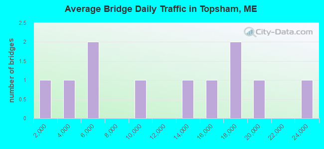
- 122,164Total average daily traffic
- 8,997Total average daily truck traffic
- National Bridge Inventory (NBI) Registered Bridges for Topsham
- No street view available for this location
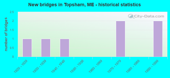
- New bridges - historical statistics
- 11920-1929
- 11930-1939
- 11940-1949
- 21970-1979
- 21990-1999
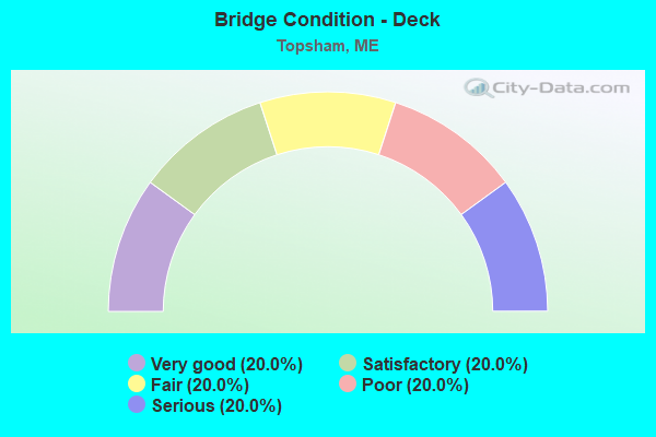
- Bridge Condition - Deck
- 20.0%Very good
- 20.0%Satisfactory
- 20.0%Fair
- 20.0%Poor
- 20.0%Serious
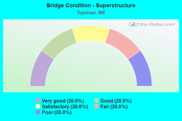
- Bridge Condition - Superstructure
- 20.0%Very good
- 20.0%Good
- 20.0%Satisfactory
- 20.0%Fair
- 20.0%Poor
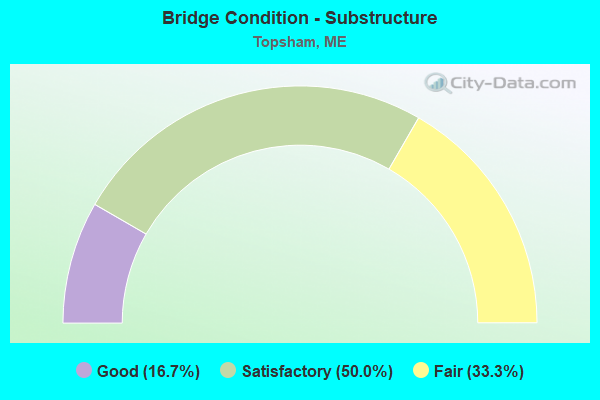
- Bridge Condition - Substructure
- 16.7%Good
- 50.0%Satisfactory
- 33.3%Fair
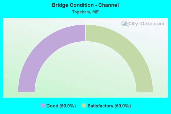
- Bridge Condition - Channel
- 50.0%Good
- 50.0%Satisfactory
Find on map >> Show street view
Structure Number: 1011, Location: 0.6 MI E RTE 201 JCT (Lat: 43.925919, Lng: -69.951931), Year Built: 1920, Status: Open, Structure Length: 1.37m (4.49ft), Average Future Daily Traffic: 5,747 (year 2034), Features Intersected: ELM STREET (RTE 24)
Lanes under structure: 2, Owner: State Highway Agency, Material/Design: Steel, Design/Construction: Stringer/Multi-beam, Number Of Spans In Main Unit: 1, Length of Maximum Span: 12.2m (40.0ft), Out-to-Out Width: 3.0m (9.8ft)
Condition: Substructure: Fair, Underclear: High priority of corrective action, Designated Inspection Frequency: Every 24 months, Inspection Date: September 2021
Find on map >> Show street view
Structure Number: 1512, Location: .5MI S JCT 196 (Lat: 43.935189, Lng: -69.987719), Route carried "on" structure: State highway 295, Year Built: 1972, Status: Open, Structure Length: 4.18m (13.71ft), Average Daily Traffic: 15,640 (year 2016), Truck Traffic: 10%, Average Future Daily Traffic: 21,896 (year 2036), Design Load: HS 20+Mod, Features Intersected: MCRR
Minimum Vertical Clearance: 30+ m (98+ ft), Kilometerpoint: 35.711, Lanes on structure: 2, Base Highway Network: Yes, Owner: State Highway Agency, Approaching Roadway Width: 12.8m (42.0ft), Skew: 1 degrees, Material/Design: Steel continuous, Design/Construction: Stringer/Multi-beam, Number Of Spans In Main Unit: 3, Length of Maximum Span: 13.4m (44.0ft), Curb or Sidewalk Widths: Left: 0.2m (0.7ft), Right: 0.2m (0.7ft), Curb-To-Curb Width: 11.9m (39.0ft), Out-to-Out Width: 13.0m (42.7ft)
Condition: Deck: Fair, Superstructure: Satisfactory, Substructure: Satisfactory, Operating Rating: 68.0 metric tons, Method Used To Determine Operating Rating: Load and Resistance Factor Rating (LRFR) rating reported by rating factor(RF) method using HL-93 loadings, Inventory Rating: 52.5 metric tons, Method Used To Determine Inventory Rating: Load and Resistance Factor Rating (LRFR) rating reported by rating factor(RF) method using HL-93 loadings, Structural Evaluation: Equal to present minimum criteria, Deck Geometry: Equal to present minimum criteria, Underclear: Equal to present minimum criteria, Approach Roadway Alignment: Better than present minimum criteria, Designated Inspection Frequency: Every 24 months, Inspection Date: December 2021, Deck Structure Type: Concrete Cast-file-Place, Wearing Surface/Protective System: Wearing Surface: Bituminous
Find on map >> Show street view
Structure Number: 2016, Location: .2 MI N US 1 (Lat: 43.921100, Lng: -69.965811), Route carried "on" structure: State highway 201, Year Built: 1931, Year Reconstructed: 1985, Status: Posted for load, Structure Length: 24.47m (80.28ft), Average Daily Traffic: 16,790 (year 2016), Truck Traffic: 5%, Average Future Daily Traffic: 23,506 (year 2036), Design Load: HS 20, Features Intersected: ANDROSCOGGIN RIVER
Minimum Vertical Clearance: 4.78m (15.68ft), Kilometerpoint: 0.145, Lanes on structure: 2, Base Highway Network: Yes, Owner: State Highway Agency, Approaching Roadway Width: 9.1m (29.9ft), Navigation Control: Yes ( Vertical Clearance: 7.6m (24.9ft), Horizontal Clearance: 50.0m (164.0ft)), Material/Design: Steel, Design/Construction: Truss - Thru, Number Of Spans In Main Unit: 3, Length of Maximum Span: 95.9m (314.6ft), Curb or Sidewalk Widths: Left: 1.5m (4.9ft), Right: 0.2m (0.7ft), Curb-To-Curb Width: 9.1m (29.9ft), Out-to-Out Width: 9.4m (30.8ft)
Condition: Deck: Serious, Superstructure: Poor, Substructure: Satisfactory, Channel: Good, Operating Rating: 22.4 metric tons, Method Used To Determine Operating Rating: Load and Resistance Factor Rating (LRFR) rating reported by rating factor(RF) method using HL-93 loadings, Inventory Rating: 17.2 metric tons, Method Used To Determine Inventory Rating: Load and Resistance Factor Rating (LRFR) rating reported by rating factor(RF) method using HL-93 loadings, Structural Evaluation: Meets minimum limits, Deck Geometry: Meets minimum limits, Waterway Adequacy: Superior to present desirable criteria, Approach Roadway Alignment: Better than present minimum criteria, Bridge Posting: Required (Relationship of Operating Rating to Maximum Legal Load: 30.0 - 39.9% below), Designated Inspection Frequency: Every 12 months, Critical Feature Inspection Frequency: Every 24 months, Underwater Inspection Frequency: Every 60 months, Inspection Date: September 2021, Critical Feature Inspection Date: September 2021, Underwater Inspection Date: August 2020, Deck Structure Type: Closed Grating, Wearing Surface/Protective System: Wearing Surface: Bituminous
Find on map >> Show street view
Structure Number: 3825, Location: 0.2 MI S JCT RTE 24 (Lat: 43.965431, Lng: -69.897131), Route carried "on" structure: City street , Year Built: 1942, Status: Open, Structure Length: 3.25m (10.66ft), Average Daily Traffic: 378 (year 2016), Truck Traffic: 5%, Average Future Daily Traffic: 605 (year 2036), Design Load: H 15, Features Intersected: MUDDY RIVER, Facility Carried by Structure: FORESIDE ROAD
Minimum Vertical Clearance: 30+ m (98+ ft), Kilometerpoint: 4.233, Lanes on structure: 2, Owner: State Highway Agency, Approaching Roadway Width: 7.6m (24.9ft), Material/Design: Steel, Design/Construction: Stringer/Multi-beam, Number Of Spans In Main Unit: 2, Length of Maximum Span: 15.7m (51.5ft), Curb or Sidewalk Widths: Left: 0.2m (0.7ft), Right: 0.2m (0.7ft), Curb-To-Curb Width: 6.7m (22.0ft), Out-to-Out Width: 7.8m (25.6ft)
Condition: Deck: Poor, Superstructure: Fair, Substructure: Fair, Channel: Satisfactory, Operating Rating: 35.6 metric tons, Method Used To Determine Operating Rating: Load and Resistance Factor Rating (LRFR) rating reported by rating factor(RF) method using HL-93 loadings, Inventory Rating: 27.5 metric tons, Method Used To Determine Inventory Rating: Load and Resistance Factor Rating (LRFR) rating reported by rating factor(RF) method using HL-93 loadings, Structural Evaluation: Somewhat better than minimum adequacy, Deck Geometry: Meets minimum limits, Waterway Adequacy: Equal to present desirable criteria, Approach Roadway Alignment: Equal to present desirable criteria, Designated Inspection Frequency: Every 24 months, Underwater Inspection Frequency: Every 60 months, Inspection Date: December 2021, Underwater Inspection Date: November 2019, Deck Structure Type: Concrete Cast-file-Place, Wearing Surface/Protective System: Wearing Surface: Latex Concrete
Find on map >> Show street view
Structure Number: 6269, Location: 1.5 MI W US 201 (Lat: 43.932389, Lng: -69.991311), Route carried "on" structure: State highway 295, Year Built: 1971, Status: Open, Structure Length: 3.05m (10.01ft), Average Daily Traffic: 16,310 (year 2016), Truck Traffic: 10%, Average Future Daily Traffic: 22,834 (year 2036), Design Load: HS 20+Mod, Features Intersected: OLD LEWISTON ROAD
Minimum Vertical Clearance: 30+ m (98+ ft), Kilometerpoint: 48.538, Lanes on structure: 2, Lanes under structure: 2, Base Highway Network: Yes, Owner: State Highway Agency, Approaching Roadway Width: 12.8m (42.0ft), Material/Design: Steel, Design/Construction: Stringer/Multi-beam, Number Of Spans In Main Unit: 1, Length of Maximum Span: 29.0m (95.1ft), Curb or Sidewalk Widths: Left: 0.2m (0.7ft), Right: 0.2m (0.7ft), Curb-To-Curb Width: 12.5m (41.0ft), Out-to-Out Width: 13.7m (44.9ft)
Condition: Deck: Satisfactory, Superstructure: Good, Substructure: Satisfactory, Operating Rating: 48.3 metric tons, Method Used To Determine Operating Rating: Load and Resistance Factor Rating (LRFR) rating reported by rating factor(RF) method using HL-93 loadings, Inventory Rating: 37.3 metric tons, Method Used To Determine Inventory Rating: Load and Resistance Factor Rating (LRFR) rating reported by rating factor(RF) method using HL-93 loadings, Structural Evaluation: Equal to present minimum criteria, Deck Geometry: Better than present minimum criteria, Underclear: Somewhat better than minimum adequacy, Approach Roadway Alignment: Better than present minimum criteria, Designated Inspection Frequency: Every 24 months, Inspection Date: June 2021, Deck Structure Type: Concrete Cast-file-Place, Wearing Surface/Protective System: Wearing Surface: Bituminous, Membrane: Preformed Fabric
Find on map >> Show street view
Structure Number: 6369, Location: 1.1 MI SE JCT RTE 201 (Lat: 43.930311, Lng: -69.948761), Route carried "on" structure: State highway 196, Year Built: 1996, Status: Open, Structure Length: 2.19m (7.19ft), Average Daily Traffic: 18,815 (year 2016), Truck Traffic: 5%, Average Future Daily Traffic: 26,341 (year 2036), Design Load: HS 25 or greater, Features Intersected: M.D.O.T. RAILROAD
Minimum Vertical Clearance: 30+ m (98+ ft), Kilometerpoint: 1.094, Lanes on structure: 2, Base Highway Network: Yes, Owner: State Highway Agency, Approaching Roadway Width: 13.4m (44.0ft), Skew: 6 degrees, Material/Design: Concrete, Design/Construction: Culvert, Number Of Spans In Main Unit: 1, Length of Maximum Span: 18.6m (61.0ft)
Condition: Culverts: Good, Operating Rating: 69.0 metric tons, Method Used To Determine Operating Rating: Load and Resistance Factor Rating (LRFR) rating reported by rating factor(RF) method using HL-93 loadings, Inventory Rating: 53.5 metric tons, Method Used To Determine Inventory Rating: Load and Resistance Factor Rating (LRFR) rating reported by rating factor(RF) method using HL-93 loadings, Structural Evaluation: Better than present minimum criteria, Underclear: Somewhat better than minimum adequacy, Approach Roadway Alignment: Better than present minimum criteria, Designated Inspection Frequency: Every 24 months, Inspection Date: July 2020
Find on map >> Show street view
Structure Number: 637, Location: 1.4 MI E JCT RTE US 201 (Lat: 43.925969, Lng: -69.951539), Route carried "on" structure: State highway 24, Year Built: 1997, Status: Open, Structure Length: 2.68m (8.79ft), Average Daily Traffic: 22,360 (year 2016), Truck Traffic: 5%, Average Future Daily Traffic: 31,304 (year 2036), Design Load: HS 25 or greater, Features Intersected: ROUTE 24, Facility Carried by Structure: ROUTE 196
Minimum Vertical Clearance: 30+ m (98+ ft), Kilometerpoint: 27.536, Lanes on structure: 4, Lanes under structure: 2, Base Highway Network: Yes, Owner: State Highway Agency, Approaching Roadway Width: 19.5m (64.0ft), Skew: 3 degrees, Material/Design: Steel, Design/Construction: Stringer/Multi-beam, Number Of Spans In Main Unit: 1, Length of Maximum Span: 22.9m (75.1ft), Curb or Sidewalk Widths: Left: 0.2m (0.7ft), Right: 0.2m (0.7ft), Curb-To-Curb Width: 19.5m (64.0ft), Out-to-Out Width: 20.3m (66.6ft)
Condition: Deck: Very good, Superstructure: Very good, Substructure: Good, Operating Rating: 34.3 metric tons, Method Used To Determine Operating Rating: Load and Resistance Factor Rating (LRFR) rating reported by rating factor(RF) method using HL-93 loadings, Inventory Rating: 20.4 metric tons, Method Used To Determine Inventory Rating: Load and Resistance Factor Rating (LRFR) rating reported by rating factor(RF) method using HL-93 loadings, Structural Evaluation: Somewhat better than minimum adequacy, Deck Geometry: Better than present minimum criteria, Underclear: Meets minimum limits, Approach Roadway Alignment: Equal to present desirable criteria, Designated Inspection Frequency: Every 24 months, Inspection Date: July 2020, Deck Structure Type: Concrete Cast-file-Place, Wearing Surface/Protective System: Wearing Surface: Bituminous, Membrane: Preformed Fabric
Find on map >> Show street view
Location: 0.6 MI E RTE 201 JCT (Lat: 43.925903, Lng: -69.951931), Route carried "on" structure: 12400, Structure Length: 0. m, Average Daily Traffic: 4,105 (year 2014), Truck Traffic: 5%, Features Intersected: STATE OF MAINE RR, Facility Carried by Structure: ELM STREET (RTE 24
Minimum Vertical Clearance: 5.33m (17.49ft), Kilometerpoint: 6.582, Lanes on structure: 2, Length of Maximum Span: 0.0m
Find on map >> Show street view
Location: 1.5 MI W US 201 (Lat: 43.932397, Lng: -69.991300), Route carried "under" structure: Business US 92400, Structure Length: 0. m, Average Daily Traffic: 2,071 (year 2014), Truck Traffic: 5%, Features Intersected: I 295 NORTHBOUND, Facility Carried by Structure: OLD LEWISTON ROAD
Minimum Vertical Clearance: 4.47m (14.67ft), Kilometerpoint: 2.607, Lanes on structure: 2, Length of Maximum Span: 0.0m
Find on map >> Show street view
Location: JCT I-95 & RTE 196 (Lat: 43.942033, Lng: -69.979022), Route carried "under" structure: State highway 72310, Structure Length: 0. m, Average Daily Traffic: 9,220 (year 2014), Truck Traffic: 11%, Features Intersected: ROUTE 196, Facility Carried by Structure: INTERSTATE 295
Minimum Vertical Clearance: 5.08m (16.67ft), Kilometerpoint: 49.954, Lanes on structure: 4, Length of Maximum Span: 0.0m
Find on map >> Show street view
Location: 0.9 MI N JCT RTE 196 (Lat: 43.948628, Lng: -69.972111), Route carried "under" structure: State highway 82310, Structure Length: 0. m, Average Daily Traffic: 12,370 (year 2014), Truck Traffic: 11%, Features Intersected: ROUTE US 201, Facility Carried by Structure: INTERSTATE 295
Minimum Vertical Clearance: 5.08m (16.67ft), Kilometerpoint: 50.807, Lanes on structure: 4, Length of Maximum Span: 0.0m
Find on map >> Show street view
Location: 1.4 MI E JCT RTE US 201 (Lat: 43.925992, Lng: -69.951494), Route carried "under" structure: Ramp State highway 2400, Structure Length: 0. m, Average Daily Traffic: 4,105 (year 2014), Truck Traffic: 5%, Features Intersected: ROUTE 196, Facility Carried by Structure: ROUTE 24
Minimum Vertical Clearance: 5.59m (18.34ft), Kilometerpoint: 6.647, Lanes on structure: 2, Length of Maximum Span: 0.0m