Bridge Statistics for Towanda, Pennsylvania (PA)
Condition, Traffic, Stress, Structural Evaluation, Project Costs
- National Bridge Inventory (NBI) Statistics
- 28Number of bridges
- 712ft / 217mTotal length
- $5,462,000Total costs
- 102,706Total average daily traffic
- 11,690Total average daily truck traffic
- National Bridge Inventory (NBI) Registered Bridges for Towanda
- No street view available for this location
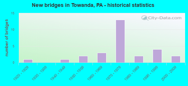
- New bridges - historical statistics
- 11920-1929
- 11940-1949
- 21950-1959
- 31960-1969
- 131970-1979
- 21980-1989
- 41990-1999
- 22000-2009
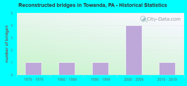
- Reconstructed bridges - Historical Statistics
- 11970-1979
- 11980-1989
- 11990-1999
- 42000-2009
- 12010-2019
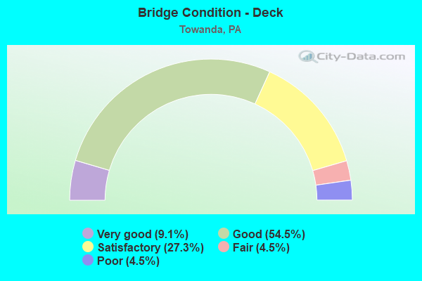
- Bridge Condition - Deck
- 9.1%Very good
- 54.5%Good
- 27.3%Satisfactory
- 4.5%Fair
- 4.5%Poor
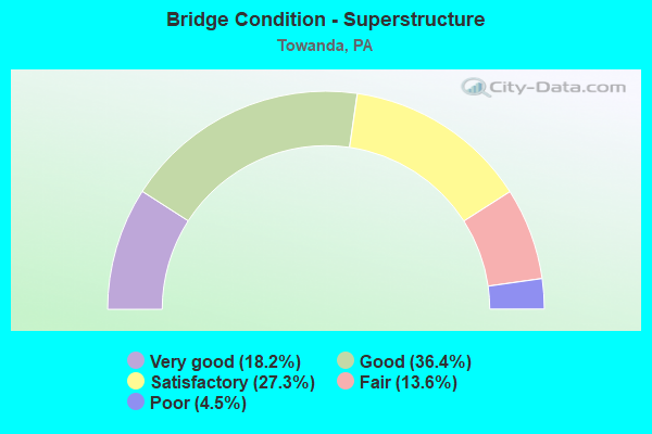
- Bridge Condition - Superstructure
- 18.2%Very good
- 36.4%Good
- 27.3%Satisfactory
- 13.6%Fair
- 4.5%Poor
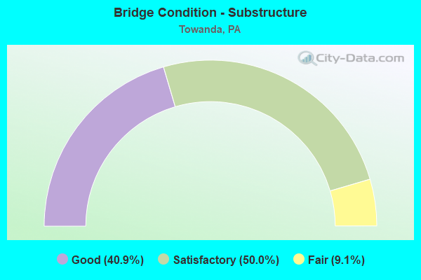
- Bridge Condition - Substructure
- 40.9%Good
- 50.0%Satisfactory
- 9.1%Fair
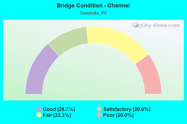
- Bridge Condition - Channel
- 26.7%Good
- 20.0%Satisfactory
- 33.3%Fair
- 20.0%Poor
Find on map >> Show street view
Structure Number: 6045, Location: 1.5 MILE NORTH OF TOWANDA (Lat: 41.794586, Lng: -76.462675), Route carried "on" structure: US 6, Year Built: 1996, Status: Open, Structure Length: 8.72m (28.61ft), Average Daily Traffic: 7,096 (year 2020), Truck Traffic: 14%, Average Future Daily Traffic: 10,996 (year 2032), Design Load: HS 25 or greater, Features Intersected: SUGAR CREEK
Minimum Vertical Clearance: 30+ m (98+ ft), Kilometerpoint: 39.781, Lanes on structure: 2, Base Highway Network: Yes, Owner: State Highway Agency, Approaching Roadway Width: 12.5m (41.0ft), Skew: 1 degrees, Material/Design: Prestressed concrete continuous, Design/Construction: Stringer/Multi-beam, Number Of Spans In Main Unit: 2, Length of Maximum Span: 43.3m (142.1ft), Curb or Sidewalk Widths: Left: 0.2m (0.7ft), Right: 0.2m (0.7ft), Curb-To-Curb Width: 12.2m (40.0ft), Out-to-Out Width: 13.3m (43.6ft)
Condition: Deck: Satisfactory, Superstructure: Good, Substructure: Good, Channel: Satisfactory, Operating Rating: 87.1 metric tons, Method Used To Determine Operating Rating: Load Factor (LF), Inventory Rating: 48.1 metric tons, Method Used To Determine Inventory Rating: Load Factor (LF), Structural Evaluation: Better than present minimum criteria, Deck Geometry: Somewhat better than minimum adequacy, Waterway Adequacy: Superior to present desirable criteria, Approach Roadway Alignment: Equal to present desirable criteria, Length Of Structure Improvement: 9.70m (31.82ft), Designated Inspection Frequency: Every 48 months, Inspection Date: December 2019, Deck Structure Type: Concrete Cast-file-Place, Wearing Surface/Protective System: Wearing Surface: Monolithic Concrete, Deck Protection: Epoxy Coated Reinforcing
Find on map >> Show street view
Structure Number: 6047, Location: TOWANDA RIVER BRIDGE (Lat: 41.761778, Lng: -76.442592), Route carried "on" structure: US 6, Year Built: 1986, Status: Open, Structure Length: 54.74m (179.59ft), Average Daily Traffic: 15,619 (year 2020), Truck Traffic: 9%, Average Future Daily Traffic: 22,245 (year 2032), Design Load: HS 25 or greater, Features Intersected: RAILROADS,SR & SUSQRIVER
Minimum Vertical Clearance: 30+ m (98+ ft), Kilometerpoint: 44.352, Lanes on structure: 2, Lanes under structure: 2, Base Highway Network: Yes, Owner: State Highway Agency, Approaching Roadway Width: 11.0m (36.1ft), Material/Design: Prestressed concrete continuous, Design/Construction: Stringer/Multi-beam, Number Of Spans In Main Unit: 12, Number Of Approach Spans: 2, Length of Maximum Span: 42.1m (138.1ft), Curb or Sidewalk Widths: Left: 1.6m (5.2ft), Right: 0.2m (0.7ft), Curb-To-Curb Width: 11.0m (36.1ft), Out-to-Out Width: 13.9m (45.6ft)
Condition: Deck: Good, Superstructure: Satisfactory, Substructure: Satisfactory, Channel: Satisfactory, Operating Rating: 74.4 metric tons, Method Used To Determine Operating Rating: Load Factor (LF), Inventory Rating: 44.5 metric tons, Method Used To Determine Inventory Rating: Load Factor (LF), Structural Evaluation: Equal to present minimum criteria, Deck Geometry: Meets minimum limits, Underclear: High priority of corrective action, Waterway Adequacy: Superior to present desirable criteria, Approach Roadway Alignment: Equal to present desirable criteria, Length Of Structure Improvement: 54.70m (179.46ft), Designated Inspection Frequency: Every 48 months, Underwater Inspection Frequency: Every 48 months, Inspection Date: July 2020, Underwater Inspection Date: July 2020, Bridge Improvement Cost: $222,000, Roadway Improvement Cost: $654,000, Total Project Cost: $2,999,000, Deck Structure Type: Concrete Cast-file-Place, Wearing Surface/Protective System: Wearing Surface: Monolithic Concrete, Deck Protection: Epoxy Coated Reinforcing
Find on map >> Show street view
Structure Number: 6049, Location: 1 MILE EAST OF WYSOX (Lat: 41.778400, Lng: -76.385817), Route carried "on" structure: US 6, Year Built: 1993, Status: Open, Structure Length: 2.96m (9.71ft), Average Daily Traffic: 7,377 (year 2022), Truck Traffic: 14%, Average Future Daily Traffic: 10,562 (year 2032), Design Load: HS 25 or greater, Features Intersected: WYSOX CREEK
Minimum Vertical Clearance: 30+ m (98+ ft), Kilometerpoint: 49.539, Lanes on structure: 2, Base Highway Network: Yes, Owner: State Highway Agency, Approaching Roadway Width: 13.4m (44.0ft), Material/Design: Prestressed concrete, Design/Construction: Box Beam or Girders - Single/Spread, Number Of Spans In Main Unit: 1, Length of Maximum Span: 28.3m (92.8ft), Curb or Sidewalk Widths: Left: 0.2m (0.7ft), Right: 0.2m (0.7ft), Curb-To-Curb Width: 13.4m (44.0ft), Out-to-Out Width: 14.5m (47.6ft)
Condition: Deck: Good, Superstructure: Good, Substructure: Good, Channel: Good, Inventory Rating: 73.5 metric tons, Method Used To Determine Inventory Rating: Load Factor (LF), Structural Evaluation: Better than present minimum criteria, Deck Geometry: Equal to present minimum criteria, Waterway Adequacy: Equal to present minimum criteria, Approach Roadway Alignment: Equal to present desirable criteria, Length Of Structure Improvement: 3.70m (12.14ft), Designated Inspection Frequency: Every 48 months, Inspection Date: August 2019, Deck Structure Type: Concrete Cast-file-Place, Wearing Surface/Protective System: Wearing Surface: Epoxy Overlay, Deck Protection: Epoxy Coated Reinforcing
Find on map >> Show street view
Structure Number: 6108, Location: WYSOX PIN/HANGER BRIDGE (Lat: 41.767786, Lng: -76.395858), Route carried "on" structure: State highway 187, Year Built: 1966, Year Reconstructed: 1993, Status: Open, Structure Length: 30.45m (99.90ft), Average Daily Traffic: 3,069 (year 2022), Truck Traffic: 14%, Average Future Daily Traffic: 5,049 (year 2041), Design Load: HS 20, Features Intersected: SUSQUEHANNA RIVER
Minimum Vertical Clearance: 30+ m (98+ ft), Kilometerpoint: 33.357, Lanes on structure: 2, Owner: State Highway Agency, Approaching Roadway Width: 9.1m (29.9ft), Material/Design: Steel continuous, Design/Construction: Girder and Floorbeam System, Number Of Spans In Main Unit: 9, Length of Maximum Span: 34.7m (113.8ft), Curb or Sidewalk Widths: Left: 0.2m (0.7ft), Right: 0.2m (0.7ft), Curb-To-Curb Width: 9.1m (29.9ft), Out-to-Out Width: 10.2m (33.5ft)
Condition: Deck: Good, Superstructure: Satisfactory, Substructure: Satisfactory, Channel: Fair, Operating Rating: 59.0 metric tons, Method Used To Determine Operating Rating: Load Factor (LF), Inventory Rating: 38.1 metric tons, Method Used To Determine Inventory Rating: Load Factor (LF), Structural Evaluation: Equal to present minimum criteria, Deck Geometry: Meets minimum limits, Waterway Adequacy: Superior to present desirable criteria, Approach Roadway Alignment: Equal to present desirable criteria, Length Of Structure Improvement: 30.90m (101.38ft), Designated Inspection Frequency: Every 24 months, Critical Feature Inspection Frequency: Every 24 months, Underwater Inspection Frequency: Every 48 months, Other Special Inspection Frequency: Every 12 months, Inspection Date: July 2021, Critical Feature Inspection Date: July 2021, Underwater Inspection Date: July 2019, Other Special Inspection Date: July 2021, Deck Structure Type: Concrete Cast-file-Place, Wearing Surface/Protective System: Wearing Surface: Epoxy Overlay
Find on map >> Show street view
Structure Number: 6145, Location: TOWANDA BORO (Lat: 41.762431, Lng: -76.452692), Route carried "on" structure: US 220, Year Built: 1974, Year Reconstructed: 2009, Status: Open, Structure Length: 4.05m (13.29ft), Average Daily Traffic: 3,339 (year 2021), Truck Traffic: 9%, Average Future Daily Traffic: 2,627 (year 2032), Design Load: HS 20, Features Intersected: SR 3018-BRIDGE ST.
Minimum Vertical Clearance: 30+ m (98+ ft), Kilometerpoint: 26.562, Lanes on structure: 2, Lanes under structure: 2, Base Highway Network: Yes, Owner: State Highway Agency, Approaching Roadway Width: 12.8m (42.0ft), Skew: 4 degrees, Material/Design: Steel, Design/Construction: Stringer/Multi-beam, Number Of Spans In Main Unit: 1, Length of Maximum Span: 38.7m (127.0ft), Curb or Sidewalk Widths: Left: 0.2m (0.7ft), Right: 0.2m (0.7ft), Curb-To-Curb Width: 13.4m (44.0ft), Out-to-Out Width: 14.6m (47.9ft)
Condition: Deck: Good, Superstructure: Good, Substructure: Satisfactory, Inventory Rating: 72.6 metric tons, Method Used To Determine Inventory Rating: Load Factor (LF), Structural Evaluation: Equal to present minimum criteria, Deck Geometry: Better than present minimum criteria, Underclear: Superior to present desirable criteria, Approach Roadway Alignment: Equal to present desirable criteria, Length Of Structure Improvement: 4.10m (13.45ft), Designated Inspection Frequency: Every 48 months, Inspection Date: June 2019, Deck Structure Type: Concrete Cast-file-Place, Wearing Surface/Protective System: Wearing Surface: Epoxy Overlay
Find on map >> Show street view
Structure Number: 6147, Location: 1 MI.W.OF TOWANDA BORO (Lat: 41.768728, Lng: -76.455222), Route carried "on" structure: US 220, Year Built: 1974, Status: Open, Structure Length: 5.76m (18.90ft), Average Daily Traffic: 3,339 (year 2021), Truck Traffic: 9%, Average Future Daily Traffic: 2,627 (year 2032), Design Load: HS 20, Features Intersected: SR 3020
Minimum Vertical Clearance: 30+ m (98+ ft), Kilometerpoint: 27.311, Lanes on structure: 2, Lanes under structure: 2, Base Highway Network: Yes, Owner: State Highway Agency, Approaching Roadway Width: 13.4m (44.0ft), Skew: 1 degrees, Material/Design: Prestressed concrete, Design/Construction: Box Beam or Girders - Single/Spread, Number Of Spans In Main Unit: 3, Length of Maximum Span: 19.8m (65.0ft), Curb or Sidewalk Widths: Left: 0.2m (0.7ft), Right: 0.2m (0.7ft), Curb-To-Curb Width: 13.5m (44.3ft), Out-to-Out Width: 14.7m (48.2ft)
Condition: Deck: Satisfactory, Superstructure: Fair, Substructure: Satisfactory, Inventory Rating: 41.7 metric tons, Method Used To Determine Inventory Rating: Load Factor (LF), Structural Evaluation: Somewhat better than minimum adequacy, Deck Geometry: Superior to present desirable criteria, Underclear: Superior to present desirable criteria, Approach Roadway Alignment: Equal to present desirable criteria, Length Of Structure Improvement: 6.70m (21.98ft), Designated Inspection Frequency: Every 24 months, Inspection Date: June 2021, Deck Structure Type: Concrete Cast-file-Place, Wearing Surface/Protective System: Wearing Surface: Epoxy Overlay
Find on map >> Show street view
Structure Number: 6148, Location: .5 MI.N.OF TOWANDA BORO (Lat: 41.781367, Lng: -76.458122), Route carried "on" structure: US 220, Year Built: 1974, Status: Open, Structure Length: 4.69m (15.39ft), Average Daily Traffic: 3,339 (year 2021), Truck Traffic: 9%, Average Future Daily Traffic: 2,627 (year 2032), Design Load: HS 20, Features Intersected: SR 2036 RAMP
Minimum Vertical Clearance: 30+ m (98+ ft), Kilometerpoint: 28.569, Lanes on structure: 4, Lanes under structure: 2, Base Highway Network: Yes, Owner: State Highway Agency, Approaching Roadway Width: 17.1m (56.1ft), Material/Design: Prestressed concrete, Design/Construction: Box Beam or Girders - Single/Spread, Number Of Spans In Main Unit: 3, Length of Maximum Span: 26.5m (86.9ft), Curb or Sidewalk Widths: Left: 0.2m (0.7ft), Right: 0.2m (0.7ft), Curb-To-Curb Width: 22.1m (72.5ft), Out-to-Out Width: 23.5m (77.1ft)
Condition: Deck: Very good, Superstructure: Good, Substructure: Good, Inventory Rating: 26.3 metric tons, Method Used To Determine Inventory Rating: Load Factor (LF), Structural Evaluation: Equal to present minimum criteria, Deck Geometry: Superior to present desirable criteria, Underclear: Somewhat better than minimum adequacy, Approach Roadway Alignment: Equal to present desirable criteria, Length Of Structure Improvement: 4.70m (15.42ft), Designated Inspection Frequency: Every 24 months, Inspection Date: July 2021, Bridge Improvement Cost: $64,000, Roadway Improvement Cost: $189,000, Total Project Cost: $866,000, Deck Structure Type: Concrete Cast-file-Place, Wearing Surface/Protective System: Wearing Surface: Epoxy Overlay, Deck Protection: Epoxy Coated Reinforcing
Find on map >> Show street view
Structure Number: 6149, Location: .5 MI.N.OF TOWANDA BORO (Lat: 41.784325, Lng: -76.460086), Route carried "on" structure: US 220, Year Built: 1974, Year Reconstructed: 2000, Status: Open, Structure Length: 15.91m (52.20ft), Average Daily Traffic: 3,341 (year 2022), Truck Traffic: 16%, Average Future Daily Traffic: 4,948 (year 2032), Design Load: HS 20, Features Intersected: SUGAR CREEK
Minimum Vertical Clearance: 30+ m (98+ ft), Kilometerpoint: 29.148, Lanes on structure: 2, Base Highway Network: Yes, Owner: State Highway Agency, Approaching Roadway Width: 14.0m (45.9ft), Skew: 2 degrees, Material/Design: Steel continuous, Design/Construction: Stringer/Multi-beam, Number Of Spans In Main Unit: 4, Length of Maximum Span: 43.9m (144.0ft), Curb or Sidewalk Widths: Left: 0.2m (0.7ft), Right: 0.2m (0.7ft), Curb-To-Curb Width: 14.6m (47.9ft), Out-to-Out Width: 14.7m (48.2ft)
Condition: Deck: Good, Superstructure: Good, Substructure: Satisfactory, Channel: Poor, Operating Rating: 69.9 metric tons, Method Used To Determine Operating Rating: Load Factor (LF), Inventory Rating: 41.7 metric tons, Method Used To Determine Inventory Rating: Load Factor (LF), Structural Evaluation: Equal to present minimum criteria, Deck Geometry: Superior to present desirable criteria, Waterway Adequacy: Superior to present desirable criteria, Approach Roadway Alignment: Equal to present desirable criteria, Length Of Structure Improvement: 15.90m (52.17ft), Designated Inspection Frequency: Every 48 months, Inspection Date: July 2019, Bridge Improvement Cost: $3,000, Roadway Improvement Cost: $45,000, Total Project Cost: $159,000, Deck Structure Type: Concrete Cast-file-Place, Wearing Surface/Protective System: Wearing Surface: Epoxy Overlay
Find on map >> Show street view
Structure Number: 615, Location: 1 MI.N.OF TOWANDA BORO (Lat: 41.789675, Lng: -76.463636), Route carried "on" structure: US 220, Year Built: 1974, Year Reconstructed: 2000, Status: Open, Structure Length: 8.78m (28.81ft), Average Daily Traffic: 3,341 (year 2022), Truck Traffic: 16%, Average Future Daily Traffic: 4,948 (year 2032), Design Load: HS 20, Features Intersected: TURN BACK= T891
Minimum Vertical Clearance: 30+ m (98+ ft), Kilometerpoint: 29.849, Lanes on structure: 2, Lanes under structure: 2, Base Highway Network: Yes, Owner: State Highway Agency, Approaching Roadway Width: 13.4m (44.0ft), Skew: 2 degrees, Material/Design: Prestressed concrete, Design/Construction: Stringer/Multi-beam, Number Of Spans In Main Unit: 3, Length of Maximum Span: 29.3m (96.1ft), Curb or Sidewalk Widths: Left: 0.2m (0.7ft), Right: 0.2m (0.7ft), Curb-To-Curb Width: 13.4m (44.0ft), Out-to-Out Width: 14.6m (47.9ft)
Condition: Deck: Good, Superstructure: Satisfactory, Substructure: Good, Operating Rating: 94.3 metric tons, Method Used To Determine Operating Rating: Load Factor (LF), Inventory Rating: 28.1 metric tons, Method Used To Determine Inventory Rating: Load Factor (LF), Structural Evaluation: Equal to present minimum criteria, Deck Geometry: Better than present minimum criteria, Underclear: Superior to present desirable criteria, Approach Roadway Alignment: Equal to present desirable criteria, Length Of Structure Improvement: 8.80m (28.87ft), Designated Inspection Frequency: Every 24 months, Inspection Date: July 2021, Bridge Improvement Cost: $44,000, Roadway Improvement Cost: $131,000, Total Project Cost: $599,000, Deck Structure Type: Concrete Cast-file-Place, Wearing Surface/Protective System: Wearing Surface: Epoxy Overlay, Deck Protection: Epoxy Coated Reinforcing
Find on map >> Show street view
Structure Number: 6151, Location: 2.5 MI NO OF TOWANDA BORO (Lat: 41.794928, Lng: -76.481947), Route carried "on" structure: US 220, Year Built: 1974, Year Reconstructed: 2001, Status: Open, Structure Length: 7.96m (26.12ft), Average Daily Traffic: 9,786 (year 2021), Truck Traffic: 7%, Average Future Daily Traffic: 12,603 (year 2032), Design Load: HS 20, Features Intersected: US 6
Minimum Vertical Clearance: 30+ m (98+ ft), Kilometerpoint: 31.609, Lanes on structure: 2, Lanes under structure: 6, Base Highway Network: Yes, Owner: State Highway Agency, Approaching Roadway Width: 13.4m (44.0ft), Skew: 4 degrees, Material/Design: Steel, Design/Construction: Stringer/Multi-beam, Number Of Spans In Main Unit: 1, Number Of Approach Spans: 2, Length of Maximum Span: 43.3m (142.1ft), Curb or Sidewalk Widths: Left: 0.2m (0.7ft), Right: 0.2m (0.7ft), Curb-To-Curb Width: 13.8m (45.3ft), Out-to-Out Width: 14.6m (47.9ft)
Condition: Deck: Good, Superstructure: Satisfactory, Substructure: Satisfactory, Operating Rating: 85.3 metric tons, Method Used To Determine Operating Rating: Load Factor (LF), Inventory Rating: 50.8 metric tons, Method Used To Determine Inventory Rating: Load Factor (LF), Structural Evaluation: Equal to present minimum criteria, Deck Geometry: Superior to present desirable criteria, Underclear: Somewhat better than minimum adequacy, Approach Roadway Alignment: Equal to present desirable criteria, Length Of Structure Improvement: 8.00m (26.25ft), Designated Inspection Frequency: Every 24 months, Inspection Date: July 2021, Deck Structure Type: Concrete Cast-file-Place, Wearing Surface/Protective System: Wearing Surface: Epoxy Overlay
Find on map >> Show street view
Structure Number: 6263, Location: 1 MILE SOUTH OF APEX (Lat: 41.806758, Lng: -76.397086), Route carried "on" structure: State highway , Year Built: 1920, Year Reconstructed: 1984, Status: Open, Structure Length: 0.82m (2.69ft), Average Daily Traffic: 169 (year 2017), Truck Traffic: 16%, Average Future Daily Traffic: 179 (year 2032), Features Intersected: POND HILL RUN, Facility Carried by Structure: SR 1029
Minimum Vertical Clearance: 30+ m (98+ ft), Kilometerpoint: 3.346, Lanes on structure: 1, Owner: State Highway Agency, Approaching Roadway Width: 5.2m (17.1ft), Material/Design: Steel, Design/Construction: Stringer/Multi-beam, Number Of Spans In Main Unit: 1, Length of Maximum Span: 6.1m (20.0ft), Curb or Sidewalk Widths: Left: 0.1m (0.3ft), Right: 0.1m (0.3ft), Curb-To-Curb Width: 5.4m (17.7ft), Out-to-Out Width: 5.4m (17.7ft)
Condition: Deck: Satisfactory, Superstructure: Fair, Substructure: Satisfactory, Channel: Good, Operating Rating: 51.7 metric tons, Method Used To Determine Operating Rating: Load Factor (LF), Inventory Rating: 30.8 metric tons, Method Used To Determine Inventory Rating: Load Factor (LF), Structural Evaluation: Somewhat better than minimum adequacy, Deck Geometry: High priority of replacement, Waterway Adequacy: Superior to present desirable criteria, Approach Roadway Alignment: High priority of corrective action, Length Of Structure Improvement: 0.80m (2.62ft), Designated Inspection Frequency: Every 24 months, Inspection Date: August 2021, Bridge Improvement Cost: $10,000, Roadway Improvement Cost: $50,000, Total Project Cost: $138,000, Deck Structure Type: Wood or Timber, Wearing Surface/Protective System: Wearing Surface: Bituminous
Find on map >> Show street view
Structure Number: 6272, Location: 1.5 MI.NW OF WYSOX (Lat: 41.780481, Lng: -76.418428), Route carried "on" structure: State highway , Year Built: 1966, Status: Open, Structure Length: 1.19m (3.90ft), Average Daily Traffic: 2,228 (year 2022), Truck Traffic: 6%, Average Future Daily Traffic: 1,172 (year 2032), Design Load: HS 20, Features Intersected: LANING CREEK, Facility Carried by Structure: SR 1033
Minimum Vertical Clearance: 30+ m (98+ ft), Kilometerpoint: 1.075, Lanes on structure: 2, Owner: State Highway Agency, Approaching Roadway Width: 5.5m (18.0ft), Skew: 1 degrees, Material/Design: Prestressed concrete, Design/Construction: Box Beam or Girders - Single/Spread, Number Of Spans In Main Unit: 1, Length of Maximum Span: 11.6m (38.1ft), Curb or Sidewalk Widths: Left: 0.5m (1.6ft), Right: 0.5m (1.6ft), Curb-To-Curb Width: 9.1m (29.9ft), Out-to-Out Width: 10.8m (35.4ft)
Condition: Deck: Satisfactory, Superstructure: Good, Substructure: Satisfactory, Channel: Fair, Operating Rating: 66.2 metric tons, Method Used To Determine Operating Rating: Load Factor (LF), Inventory Rating: 28.1 metric tons, Method Used To Determine Inventory Rating: Load Factor (LF), Structural Evaluation: Equal to present minimum criteria, Deck Geometry: Meets minimum limits, Waterway Adequacy: Superior to present desirable criteria, Approach Roadway Alignment: Equal to present desirable criteria, Length Of Structure Improvement: 1.20m (3.94ft), Designated Inspection Frequency: Every 24 months, Inspection Date: August 2021, Bridge Improvement Cost: $7,000, Roadway Improvement Cost: $50,000, Total Project Cost: $99,000, Deck Structure Type: Concrete Cast-file-Place, Wearing Surface/Protective System: Wearing Surface: Epoxy Overlay, Deck Protection: Epoxy Coated Reinforcing
Find on map >> Show street view
Structure Number: 6274, Location: 1.5 MI.SE OF BLACK (Lat: 41.808528, Lng: -76.416831), Route carried "on" structure: State highway , Year Built: 1966, Year Reconstructed: 2009, Status: Open, Structure Length: 1.16m (3.81ft), Average Daily Traffic: 208 (year 2018), Truck Traffic: 5%, Average Future Daily Traffic: 230 (year 2032), Design Load: HS 20, Features Intersected: LANING CREEK, Facility Carried by Structure: SR 1033
Minimum Vertical Clearance: 30+ m (98+ ft), Kilometerpoint: 4.580, Lanes on structure: 2, Owner: State Highway Agency, Approaching Roadway Width: 5.5m (18.0ft), Material/Design: Prestressed concrete, Design/Construction: Box Beam or Girders - Single/Spread, Number Of Spans In Main Unit: 1, Length of Maximum Span: 11.0m (36.1ft), Curb or Sidewalk Widths: Left: 0.5m (1.6ft), Right: 0.5m (1.6ft), Curb-To-Curb Width: 9.1m (29.9ft), Out-to-Out Width: 10.4m (34.1ft)
Condition: Deck: Good, Superstructure: Very good, Substructure: Satisfactory, Channel: Fair, Operating Rating: 60.8 metric tons, Method Used To Determine Operating Rating: Load Factor (LF), Inventory Rating: 29.9 metric tons, Method Used To Determine Inventory Rating: Load Factor (LF), Structural Evaluation: Equal to present minimum criteria, Deck Geometry: Equal to present minimum criteria, Waterway Adequacy: Superior to present desirable criteria, Approach Roadway Alignment: Equal to present desirable criteria, Length Of Structure Improvement: 1.20m (3.94ft), Designated Inspection Frequency: Every 24 months, Inspection Date: August 2021, Bridge Improvement Cost: $9,000, Roadway Improvement Cost: $50,000, Total Project Cost: $120,000, Deck Structure Type: Concrete Cast-file-Place, Wearing Surface/Protective System: Wearing Surface: Monolithic Concrete, Deck Protection: Galvanized Reinforcing
Find on map >> Show street view
Structure Number: 6285, Location: TOWANDA RIVER BR.JAMES ST (Lat: 41.790939, Lng: -76.444214), Route carried "on" structure: State highway , Year Built: 1977, Status: Open, Structure Length: 49.04m (160.89ft), Average Daily Traffic: 1,874 (year 2020), Truck Traffic: 8%, Average Future Daily Traffic: 4,395 (year 2032), Design Load: HS 20, Features Intersected: NS/LEHIGH RR/NO BR SUS R, Facility Carried by Structure: SR 1041
Minimum Vertical Clearance: 30+ m (98+ ft), Kilometerpoint: 0.523, Lanes on structure: 2, Owner: State Highway Agency, Approaching Roadway Width: 12.8m (42.0ft), Material/Design: Steel continuous, Design/Construction: Stringer/Multi-beam, Number Of Spans In Main Unit: 13, Length of Maximum Span: 42.4m (139.1ft), Curb or Sidewalk Widths: Left: 0.2m (0.7ft), Right: 0.2m (0.7ft), Curb-To-Curb Width: 13.4m (44.0ft), Out-to-Out Width: 14.6m (47.9ft)
Condition: Deck: Good, Superstructure: Satisfactory, Substructure: Satisfactory, Channel: Poor, Operating Rating: 70.8 metric tons, Method Used To Determine Operating Rating: Load Factor (LF), Inventory Rating: 42.6 metric tons, Method Used To Determine Inventory Rating: Load Factor (LF), Structural Evaluation: Equal to present minimum criteria, Deck Geometry: Equal to present desirable criteria, Underclear: High priority of corrective action, Waterway Adequacy: Superior to present desirable criteria, Approach Roadway Alignment: Better than present minimum criteria, Length Of Structure Improvement: 49.80m (163.39ft), Designated Inspection Frequency: Every 24 months, Underwater Inspection Frequency: Every 24 months, Inspection Date: July 2021, Underwater Inspection Date: July 2021, Deck Structure Type: Concrete Cast-file-Place, Wearing Surface/Protective System: Wearing Surface: Epoxy Overlay, Deck Protection: Epoxy Coated Reinforcing
Find on map >> Show street view
Structure Number: 6387, Location: 2 MI. S.OF TOWANDA BORO (Lat: 41.742050, Lng: -76.449114), Route carried "on" structure: State highway , Year Built: 1959, Status: Open, Structure Length: 0.64m (2.10ft), Average Daily Traffic: 5,550 (year 2020), Truck Traffic: 16%, Average Future Daily Traffic: 7,924 (year 2032), Features Intersected: TRIBUTARY TOWANDA CREEK, Facility Carried by Structure: SR 2027
Minimum Vertical Clearance: 30+ m (98+ ft), Kilometerpoint: 0.000, Lanes on structure: 2, Base Highway Network: Yes, Owner: State Highway Agency, Approaching Roadway Width: 11.0m (36.1ft), Material/Design: Concrete, Design/Construction: Slab, Number Of Spans In Main Unit: 1, Length of Maximum Span: 6.1m (20.0ft), Curb or Sidewalk Widths: Left: 0.2m (0.7ft), Right: 0.2m (0.7ft), Curb-To-Curb Width: 12.3m (40.4ft), Out-to-Out Width: 13.3m (43.6ft)
Condition: Deck: Satisfactory, Superstructure: Satisfactory, Substructure: Fair, Channel: Satisfactory, Operating Rating: 54.4 metric tons, Method Used To Determine Operating Rating: Field evaluation and documented engineering judgment, Inventory Rating: 32.7 metric tons, Method Used To Determine Inventory Rating: Field evaluation and documented engineering judgment, Structural Evaluation: Somewhat better than minimum adequacy, Deck Geometry: Somewhat better than minimum adequacy, Waterway Adequacy: Superior to present desirable criteria, Approach Roadway Alignment: Equal to present desirable criteria, Length Of Structure Improvement: 0.60m (1.97ft), Designated Inspection Frequency: Every 24 months, Inspection Date: June 2021, Bridge Improvement Cost: $8,000, Roadway Improvement Cost: $50,000, Total Project Cost: $106,000, Wearing Surface/Protective System: Wearing Surface: Bituminous, Membrane: Preformed Fabric
Find on map >> Show street view
Structure Number: 6389, Location: LEISURE DR-1M.E OFTOWANDA (Lat: 41.769000, Lng: -76.415139), Route carried "on" structure: State highway , Year Built: 1991, Status: Open, Structure Length: 2.80m (9.19ft), Average Daily Traffic: 1,194 (year 2022), Truck Traffic: 12%, Average Future Daily Traffic: 1,371 (year 2032), Design Load: HS 25 or greater, Features Intersected: NORFOLK SOUTHERN, Facility Carried by Structure: SR 2032
Minimum Vertical Clearance: 30+ m (98+ ft), Kilometerpoint: 0.000, Lanes on structure: 2, Owner: State Highway Agency, Approaching Roadway Width: 9.1m (29.9ft), Skew: 4 degrees, Material/Design: Prestressed concrete, Design/Construction: Box Beam or Girders - Multiple, Number Of Spans In Main Unit: 1, Length of Maximum Span: 25.0m (82.0ft), Curb or Sidewalk Widths: Left: 0.2m (0.7ft), Right: 0.2m (0.7ft), Curb-To-Curb Width: 9.2m (30.2ft), Out-to-Out Width: 10.2m (33.5ft)
Condition: Deck: Good, Superstructure: Good, Substructure: Good, Inventory Rating: 75.3 metric tons, Method Used To Determine Inventory Rating: Load Factor (LF), Structural Evaluation: Better than present minimum criteria, Deck Geometry: Somewhat better than minimum adequacy, Underclear: High priority of corrective action, Approach Roadway Alignment: Equal to present desirable criteria, Length Of Structure Improvement: 2.80m (9.19ft), Designated Inspection Frequency: Every 48 months, Inspection Date: August 2019, Deck Structure Type: Concrete Cast-file-Place, Wearing Surface/Protective System: Wearing Surface: Bituminous, Membrane: Preformed Fabric
Find on map >> Show street view
Structure Number: 639, Location: 1 MI.E.OF TOWANDA BORO (Lat: 41.759972, Lng: -76.433606), Route carried "on" structure: State highway , Year Built: 1958, Year Reconstructed: 2010, Status: Open, Structure Length: 1.01m (3.31ft), Average Daily Traffic: 1,775 (year 2021), Truck Traffic: 33%, Average Future Daily Traffic: 1,199 (year 2032), Design Load: HL 93, Features Intersected: LANING CREEK, Facility Carried by Structure: SR 2032
Minimum Vertical Clearance: 30+ m (98+ ft), Kilometerpoint: 4.117, Lanes on structure: 2, Owner: State Highway Agency, Approaching Roadway Width: 7.3m (24.0ft), Material/Design: Prestressed concrete, Design/Construction: Box Beam or Girders - Multiple, Number Of Spans In Main Unit: 1, Length of Maximum Span: 9.8m (32.2ft), Curb or Sidewalk Widths: Left: 0.1m (0.3ft), Right: 0.1m (0.3ft), Curb-To-Curb Width: 9.2m (30.2ft), Out-to-Out Width: 10.4m (34.1ft)
Condition: Deck: Satisfactory, Superstructure: Very good, Substructure: Fair, Channel: Fair, Operating Rating: 59.9 metric tons, Method Used To Determine Operating Rating: Load and Resistance Factor (LRFR), Inventory Rating: 46.3 metric tons, Method Used To Determine Inventory Rating: Load and Resistance Factor (LRFR), Structural Evaluation: Somewhat better than minimum adequacy, Deck Geometry: Somewhat better than minimum adequacy, Waterway Adequacy: Equal to present minimum criteria, Approach Roadway Alignment: Equal to present desirable criteria, Length Of Structure Improvement: 1.00m (3.28ft), Designated Inspection Frequency: Every 24 months, Inspection Date: August 2021, Bridge Improvement Cost: $6,000, Roadway Improvement Cost: $50,000, Total Project Cost: $80,000, Wearing Surface/Protective System: Wearing Surface: Monolithic Concrete, Deck Protection: Epoxy Coated Reinforcing
Find on map >> Show street view
Structure Number: 6425, Location: BRIDGE ST, TOWANDA BORO (Lat: 41.765400, Lng: -76.442256), Route carried "on" structure: State highway , Year Built: 1940, Status: Open, Structure Length: 0.98m (3.22ft), Average Daily Traffic: 1,132 (year 2021), Truck Traffic: 4%, Average Future Daily Traffic: 820 (year 2032), Features Intersected: MONRTNSHIPPERSLIFELINERR, Facility Carried by Structure: SR 3018
Minimum Vertical Clearance: 30+ m (98+ ft), Kilometerpoint: 6.756, Lanes on structure: 2, Owner: State Highway Agency, Approaching Roadway Width: 10.4m (34.1ft), Material/Design: Concrete continuous, Design/Construction: Stringer/Multi-beam, Number Of Spans In Main Unit: 1, Length of Maximum Span: 9.8m (32.2ft), Curb or Sidewalk Widths: Left: 1.8m (5.9ft), Right: 1.8m (5.9ft), Curb-To-Curb Width: 10.4m (34.1ft), Out-to-Out Width: 14.6m (47.9ft)
Condition: Deck: Fair, Superstructure: Fair, Substructure: Satisfactory, Operating Rating: 54.4 metric tons, Method Used To Determine Operating Rating: Field evaluation and documented engineering judgment, Inventory Rating: 32.7 metric tons, Method Used To Determine Inventory Rating: Field evaluation and documented engineering judgment, Structural Evaluation: Somewhat better than minimum adequacy, Deck Geometry: Equal to present minimum criteria, Underclear: High priority of corrective action, Approach Roadway Alignment: Equal to present desirable criteria, Length Of Structure Improvement: 1.00m (3.28ft), Designated Inspection Frequency: Every 24 months, Inspection Date: June 2021, Bridge Improvement Cost: $21,000, Roadway Improvement Cost: $63,000, Total Project Cost: $288,000, Deck Structure Type: Concrete Cast-file-Place, Wearing Surface/Protective System: Wearing Surface: Bituminous
Find on map >> Show street view
Structure Number: 6643, Location: 4.4 MI. EAST OF ULSTER (Lat: 41.834131, Lng: -76.418472), Route carried "on" structure: City street , Year Built: 1977, Status: Posted for load, Structure Length: 1.07m (3.51ft), Average Daily Traffic: 50 (year 2021), Truck Traffic: 6%, Average Future Daily Traffic: 77 (year 2043), Design Load: HS 20, Features Intersected: LANING CREEK, Facility Carried by Structure: T-720 (BR # 4)
Minimum Vertical Clearance: 30+ m (98+ ft), Kilometerpoint: 0.000, Lanes on structure: 2, Owner: Town or Township Highway Agency, Approaching Roadway Width: 5.8m (19.0ft), Skew: 2 degrees, Material/Design: Prestressed concrete, Design/Construction: Box Beam or Girders - Multiple, Number Of Spans In Main Unit: 1, Length of Maximum Span: 10.1m (33.1ft), Curb-To-Curb Width: 6.7m (22.0ft), Out-to-Out Width: 7.8m (25.6ft)
Condition: Deck: Poor, Superstructure: Poor, Substructure: Good, Channel: Fair, Operating Rating: 47.2 metric tons, Method Used To Determine Operating Rating: Load Factor (LF), Inventory Rating: 27.2 metric tons, Method Used To Determine Inventory Rating: Load Factor (LF), Structural Evaluation: Meets minimum limits, Deck Geometry: Somewhat better than minimum adequacy, Waterway Adequacy: Better than present minimum criteria, Approach Roadway Alignment: Equal to present desirable criteria, Length Of Structure Improvement: 1.10m (3.61ft), Designated Inspection Frequency: Every 24 months, Other Special Inspection Frequency: Every 12 months, Inspection Date: June 2021, Other Special Inspection Date: June 2021, Bridge Improvement Cost: $1,000, Roadway Improvement Cost: $5,000, Total Project Cost: $8,000 ( Estimate for 2022), Deck Structure Type: Other, Wearing Surface/Protective System: Wearing Surface: Bituminous
Find on map >> Show street view
Structure Number: 40173, Location: 1 MILE WEST OF WYSOX (Lat: 41.769550, Lng: -76.422081), Route carried "on" structure: US 6, Year Built: 1998, Status: Open, Structure Length: 2.50m (8.20ft), Average Daily Traffic: 13,879 (year 2020), Truck Traffic: 13%, Average Future Daily Traffic: 16,545 (year 2032), Features Intersected: LITTLE WYSOX CREEK
Minimum Vertical Clearance: 30+ m (98+ ft), Kilometerpoint: 46.347, Lanes on structure: 4, Base Highway Network: Yes, Owner: State Highway Agency, Approaching Roadway Width: 11.3m (37.1ft), Skew: 4 degrees, Material/Design: Prestressed concrete, Design/Construction: Box Beam or Girders - Multiple, Number Of Spans In Main Unit: 1, Length of Maximum Span: 24.4m (80.1ft), Curb or Sidewalk Widths: Left: 0.2m (0.7ft), Right: 1.5m (4.9ft), Curb-To-Curb Width: 14.7m (48.2ft), Out-to-Out Width: 17.5m (57.4ft)
Condition: Deck: Good, Superstructure: Very good, Substructure: Good, Channel: Good, Inventory Rating: 46.3 metric tons, Method Used To Determine Inventory Rating: Load Factor (LF), Structural Evaluation: Better than present minimum criteria, Deck Geometry: High priority of replacement, Waterway Adequacy: Superior to present desirable criteria, Approach Roadway Alignment: Equal to present desirable criteria, Length Of Structure Improvement: 2.50m (8.20ft), Designated Inspection Frequency: Every 48 months, Inspection Date: August 2019, Deck Structure Type: Concrete Cast-file-Place, Wearing Surface/Protective System: Wearing Surface: Epoxy Overlay, Deck Protection: Epoxy Coated Reinforcing
Find on map >> Show street view
Structure Number: 42951, Location: .5 MILE EAST OF AIRPORT (Lat: 41.739428, Lng: -76.434325), Route carried "on" structure: State highway , Year Built: 2005, Status: Open, Structure Length: 7.92m (25.98ft), Average Daily Traffic: 1,334 (year 2022), Truck Traffic: 6%, Average Future Daily Traffic: 1,039 (year 2032), Design Load: HL 93, Features Intersected: TOWANDA CREEK, Facility Carried by Structure: SR 2024
Minimum Vertical Clearance: 30+ m (98+ ft), Kilometerpoint: 1.271, Lanes on structure: 2, Owner: State Highway Agency, Approaching Roadway Width: 11.3m (37.1ft), Material/Design: Steel continuous, Design/Construction: Stringer/Multi-beam, Number Of Spans In Main Unit: 2, Length of Maximum Span: 38.7m (127.0ft), Curb-To-Curb Width: 9.8m (32.2ft), Out-to-Out Width: 10.8m (35.4ft)
Condition: Deck: Good, Superstructure: Good, Substructure: Good, Channel: Poor, Operating Rating: 74.4 metric tons, Method Used To Determine Operating Rating: Load and Resistance Factor (LRFR), Inventory Rating: 58.1 metric tons, Method Used To Determine Inventory Rating: Load and Resistance Factor (LRFR), Structural Evaluation: Better than present minimum criteria, Deck Geometry: Somewhat better than minimum adequacy, Waterway Adequacy: Superior to present desirable criteria, Approach Roadway Alignment: Equal to present minimum criteria, Length Of Structure Improvement: 7.90m (25.92ft), Designated Inspection Frequency: Every 48 months, Inspection Date: June 2019, Deck Structure Type: Concrete Cast-file-Place, Wearing Surface/Protective System: Wearing Surface: Monolithic Concrete, Deck Protection: Epoxy Coated Reinforcing
Find on map >> Show street view
Structure Number: 44237, Location: 2.6 Mi W.OF NORTH TOWANDA (Lat: 41.781100, Lng: -76.502575), Route carried "on" structure: County highway , Year Built: 2007, Status: Open, Structure Length: 3.78m (12.40ft), Average Daily Traffic: 46 (year 2021), Average Future Daily Traffic: 71 (year 2043), Design Load: HL 93, Features Intersected: SUGAR CREEK, Facility Carried by Structure: T-544 CTY BR # 32
Minimum Vertical Clearance: 30+ m (98+ ft), Kilometerpoint: 0.000, Lanes on structure: 1, Owner: County Highway Agency, Approaching Roadway Width: 5.5m (18.0ft), Material/Design: Prestressed concrete, Design/Construction: Box Beam or Girders - Multiple, Number Of Spans In Main Unit: 1, Length of Maximum Span: 37.5m (123.0ft), Curb-To-Curb Width: 4.8m (15.7ft), Out-to-Out Width: 5.8m (19.0ft)
Condition: Deck: Very good, Superstructure: Very good, Substructure: Good, Channel: Good, Operating Rating: 98.9 metric tons, Method Used To Determine Operating Rating: Load and Resistance Factor (LRFR), Inventory Rating: 42.6 metric tons, Method Used To Determine Inventory Rating: Load and Resistance Factor (LRFR), Structural Evaluation: Better than present minimum criteria, Deck Geometry: Equal to present desirable criteria, Waterway Adequacy: Equal to present desirable criteria, Approach Roadway Alignment: Equal to present minimum criteria, Designated Inspection Frequency: Every 24 months, Inspection Date: June 2021, Deck Structure Type: Concrete Cast-file-Place, Wearing Surface/Protective System: Wearing Surface: Monolithic Concrete, Deck Protection: Epoxy Coated Reinforcing
Find on map >> Show street view
Structure Number: 6047, Location: TOWANDA RIVER BRIDGE (Lat: 41.761778, Lng: -76.442592), Route carried "under" structure: ServiceCity street , Year Built: 1986, Structure Length: 0. m, Average Daily Traffic: 3,413 (year 2007), Truck Traffic: 5%, Features Intersected: RAILROADS,SR & SUSQRIVER, Facility Carried by Structure: US 6
Minimum Vertical Clearance: 6.16m (20.21ft), Kilometerpoint: 0.000, Lanes on structure: 2, Lanes under structure: 2, Material/Design: Prestressed concrete continuous, Design/Construction: Stringer/Multi-beam, Length of Maximum Span: 42.1m (138.1ft)
Find on map >> Show street view
Structure Number: 6145, Location: TOWANDA BORO (Lat: 41.762431, Lng: -76.452692), Route carried "under" structure: State highway , Year Built: 1974, Structure Length: 0. m, Average Daily Traffic: 613 (year 2022), Truck Traffic: 5%, Features Intersected: SR 3018-BRIDGE ST., Facility Carried by Structure: SR 220
Minimum Vertical Clearance: 5.69m (18.67ft), Kilometerpoint: 5.406, Lanes on structure: 2, Lanes under structure: 2, Material/Design: Steel, Design/Construction: Stringer/Multi-beam, Length of Maximum Span: 38.7m (127.0ft)
Find on map >> Show street view
Structure Number: 6147, Location: 1 MI.W.OF TOWANDA BORO (Lat: 41.768728, Lng: -76.455222), Route carried "under" structure: State highway , Year Built: 1974, Structure Length: 0. m, Average Daily Traffic: 487 (year 2020), Truck Traffic: 4%, Features Intersected: SR 3020, Facility Carried by Structure: SR 0220
Minimum Vertical Clearance: 9.04m (29.66ft), Kilometerpoint: 9.125, Lanes on structure: 2, Lanes under structure: 2, Material/Design: Prestressed concrete, Design/Construction: Box Beam or Girders - Single/Spread, Length of Maximum Span: 19.8m (65.0ft)
Find on map >> Show street view
Structure Number: 6148, Location: .5 MI.N.OF TOWANDA BORO (Lat: 41.781367, Lng: -76.458122), Route carried "under" structure: Spur State highway , Year Built: 1974, Structure Length: 0. m, Average Daily Traffic: 2,012 (year 2020), Truck Traffic: 5%, Features Intersected: SR 2036 RAMP, Facility Carried by Structure: SR 0220
Minimum Vertical Clearance: 4.49m (14.73ft), Kilometerpoint: 0.000, Lanes on structure: 4, Lanes under structure: 2, Material/Design: Prestressed concrete, Design/Construction: Box Beam or Girders - Single/Spread, Length of Maximum Span: 26.5m (86.9ft)
Find on map >> Show street view
Structure Number: 6151, Location: 2.5 MI NO OF TOWANDA BORO (Lat: 41.794928, Lng: -76.481947), Route carried "under" structure: US 6, Year Built: 1974, Structure Length: 0. m, Average Daily Traffic: 3,548 (year 2020), Truck Traffic: 14%, Features Intersected: US 6, Facility Carried by Structure: US 220
Minimum Vertical Clearance: 5.08m (16.67ft), Kilometerpoint: 38.563, Lanes on structure: 2, Lanes under structure: 3, Material/Design: Steel, Design/Construction: Stringer/Multi-beam, Length of Maximum Span: 43.3m (142.1ft)
Find on map >> Show street view
Structure Number: 6151, Location: 2.5 MI NO OF TOWANDA BORO (Lat: 41.794928, Lng: -76.481947), Route carried "under" structure: US 6, Year Built: 1974, Structure Length: 0. m, Average Daily Traffic: 3,548 (year 2020), Truck Traffic: 14%, Features Intersected: US 6, Facility Carried by Structure: US 220
Minimum Vertical Clearance: 4.34m (14.24ft), Kilometerpoint: 38.545, Lanes on structure: 2, Lanes under structure: 3, Material/Design: Steel, Design/Construction: Stringer/Multi-beam, Length of Maximum Span: 43.3m (142.1ft)