Bridge Statistics for Townsend, Massachusetts (MA)
Condition, Traffic, Stress, Structural Evaluation, Project Costs
- National Bridge Inventory (NBI) Statistics
- 10Number of bridges
- 59ft / 17.5mTotal length
- $13,592,000Total costs
- 32,925Total average daily traffic
- 2,892Total average daily truck traffic
- National Bridge Inventory (NBI) Registered Bridges for Townsend
- No street view available for this location
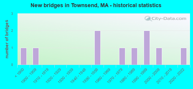
- New bridges - historical statistics
- 1Before 1900
- 11900-1909
- 21950-1959
- 11970-1979
- 11980-1989
- 21990-1999
- 12000-2009
- 12020-2022
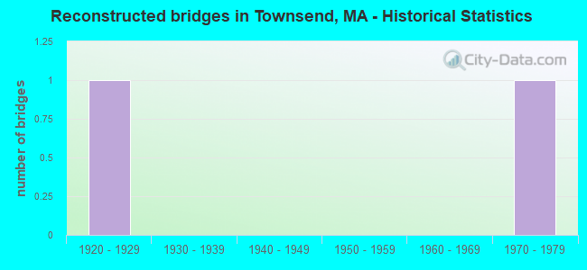
- Reconstructed bridges - Historical Statistics
- 11920-1929
- 01930-1939
- 01940-1949
- 01950-1959
- 01960-1969
- 11970-1979
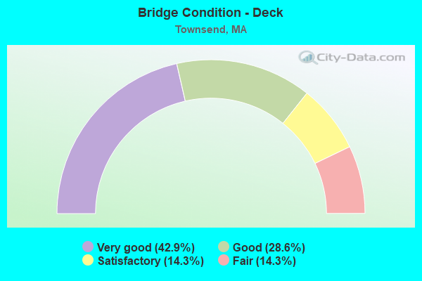
- Bridge Condition - Deck
- 42.9%Very good
- 28.6%Good
- 14.3%Satisfactory
- 14.3%Fair
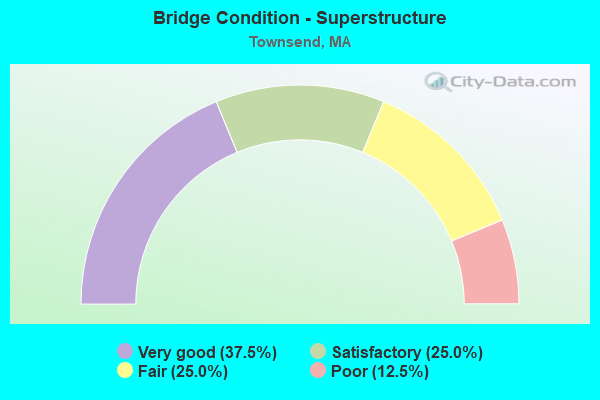
- Bridge Condition - Superstructure
- 37.5%Very good
- 25.0%Satisfactory
- 25.0%Fair
- 12.5%Poor
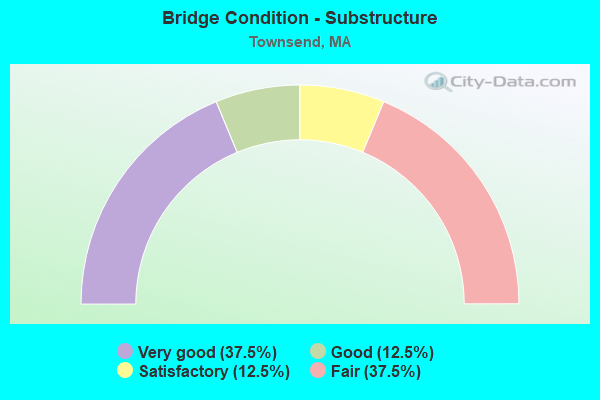
- Bridge Condition - Substructure
- 37.5%Very good
- 12.5%Good
- 12.5%Satisfactory
- 37.5%Fair
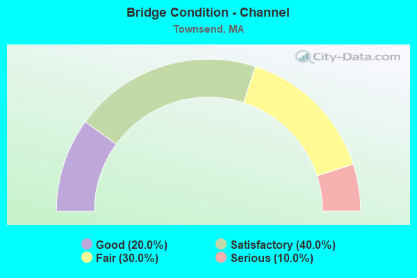
- Bridge Condition - Channel
- 20.0%Good
- 40.0%Satisfactory
- 30.0%Fair
- 10.0%Serious
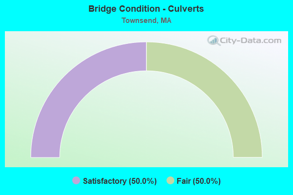
- Bridge Condition - Culverts
- 50.0%Satisfactory
- 50.0%Fair
Find on map >> Show street view
Structure Number: T07001AYUMUNNBI, Location: 150 FT. S. OF ST-119 (Lat: 42.652428, Lng: -71.672261), Route carried "on" structure: City street , Year Built: 2004, Status: Open, Structure Length: 3.04m (9.97ft), Average Daily Traffic: 1,500 (year 2015), Truck Traffic: 1%, Average Future Daily Traffic: 2,369 (year 2032), Design Load: HS 20, Features Intersected: WATER SQUANNACOOK RIVER, Facility Carried by Structure: HWY SOUTH ST
Minimum Vertical Clearance: 30+ m (98+ ft), Kilometerpoint: 0.483, Lanes on structure: 2, Owner: Town or Township Highway Agency, Approaching Roadway Width: 8.5m (27.9ft), Skew: 1 degrees, Material/Design: Prestressed concrete, Design/Construction: Box Beam or Girders - Single/Spread, Number Of Spans In Main Unit: 1, Length of Maximum Span: 28.6m (93.8ft), Curb or Sidewalk Widths: Left: 1.5m (4.9ft), Right: 0.0m, Curb-To-Curb Width: 8.5m (27.9ft), Out-to-Out Width: 10.9m (35.8ft)
Condition: Deck: Good, Superstructure: Very good, Substructure: Very good, Channel: Satisfactory, Inventory Rating: 79.6 metric tons, Method Used To Determine Inventory Rating: Load Factor (LF), Structural Evaluation: Equal to present desirable criteria, Deck Geometry: Somewhat better than minimum adequacy, Waterway Adequacy: Equal to present desirable criteria, Approach Roadway Alignment: Equal to present minimum criteria, Length Of Structure Improvement: 3.10m (10.17ft), Designated Inspection Frequency: Every 24 months, Inspection Date: January 2021, Bridge Improvement Cost: $1,433,000, Roadway Improvement Cost: $144,000, Total Project Cost: $2,150,000 ( Estimate for 2022), Deck Structure Type: Concrete Cast-file-Place, Wearing Surface/Protective System: Wearing Surface: Monolithic Concrete, Deck Protection: Epoxy Coated Reinforcing
Find on map >> Show street view
Structure Number: T0700326TDOTNBI, Location: 0.3 MI S OF RT 119 (Lat: 42.663447, Lng: -71.709075), Route carried "on" structure: State highway 13, Year Built: 1971, Status: Open, Structure Length: 2.23m (7.32ft), Average Daily Traffic: 9,300 (year 2012), Truck Traffic: 9%, Average Future Daily Traffic: 14,687 (year 2031), Design Load: H 20, Features Intersected: WATER SQUANNACOOK RIVER
Minimum Vertical Clearance: 30+ m (98+ ft), Kilometerpoint: 17.023, Lanes on structure: 2, Base Highway Network: Yes, Owner: State Highway Agency, Approaching Roadway Width: 12.2m (40.0ft), Material/Design: Prestressed concrete, Design/Construction: Box Beam or Girders - Single/Spread, Number Of Spans In Main Unit: 1, Length of Maximum Span: 20.1m (65.9ft), Curb or Sidewalk Widths: Left: 1.8m (5.9ft), Right: 0.5m (1.6ft), Curb-To-Curb Width: 12.2m (40.0ft), Out-to-Out Width: 15.0m (49.2ft)
Condition: Deck: Fair, Superstructure: Fair, Substructure: Fair, Channel: Good, Operating Rating: 49.9 metric tons, Method Used To Determine Operating Rating: Allowable Stress (AS), Inventory Rating: 27.0 metric tons, Method Used To Determine Inventory Rating: Allowable Stress (AS), Structural Evaluation: Somewhat better than minimum adequacy, Deck Geometry: Somewhat better than minimum adequacy, Waterway Adequacy: Equal to present desirable criteria, Approach Roadway Alignment: Equal to present desirable criteria, Length Of Structure Improvement: 2.30m (7.55ft), Designated Inspection Frequency: Every 24 months, Inspection Date: December 2020, Bridge Improvement Cost: $1,356,000, Roadway Improvement Cost: $136,000, Total Project Cost: $2,035,000 ( Estimate for 2022), Deck Structure Type: Concrete Cast-file-Place, Wearing Surface/Protective System: Wearing Surface: Bituminous
Find on map >> Show street view
Structure Number: T0700426YDOTNBI, Location: 0.2 MI WLY RT 13 (Lat: 42.668033, Lng: -71.708494), Route carried "on" structure: State highway 119, Year Built: 1950, Status: Posted for load, Structure Length: 2.87m (9.42ft), Average Daily Traffic: 9,398 (year 2013), Truck Traffic: 12%, Average Future Daily Traffic: 29,059 (year 2031), Design Load: H 20, Features Intersected: WATER SQUANNACOOK RIVER
Minimum Vertical Clearance: 30+ m (98+ ft), Kilometerpoint: 21.112, Lanes on structure: 2, Owner: State Highway Agency, Approaching Roadway Width: 9.1m (29.9ft), Skew: 2 degrees, Material/Design: Steel, Design/Construction: Stringer/Multi-beam, Number Of Spans In Main Unit: 1, Length of Maximum Span: 27.1m (88.9ft), Curb or Sidewalk Widths: Left: 1.7m (5.6ft), Right: 1.7m (5.6ft), Curb-To-Curb Width: 9.1m (29.9ft), Out-to-Out Width: 13.0m (42.7ft)
Condition: Deck: Satisfactory, Superstructure: Satisfactory, Substructure: Fair, Channel: Satisfactory, Operating Rating: 27.5 metric tons, Method Used To Determine Operating Rating: Load Factor (LF), Inventory Rating: 16.5 metric tons, Method Used To Determine Inventory Rating: Load Factor (LF), Structural Evaluation: Meets minimum limits, Deck Geometry: High priority of corrective action, Waterway Adequacy: Equal to present desirable criteria, Approach Roadway Alignment: Better than present minimum criteria, Bridge Posting: Required (Relationship of Operating Rating to Maximum Legal Load: 10.0 - 19.9% below), Length Of Structure Improvement: 2.90m (9.51ft), Designated Inspection Frequency: Every 24 months, Inspection Date: September 2020, Bridge Improvement Cost: $1,481,000, Roadway Improvement Cost: $149,000, Total Project Cost: $2,222,000 ( Estimate for 2022), Deck Structure Type: Concrete Cast-file-Place, Wearing Surface/Protective System: Wearing Surface: Bituminous
Find on map >> Show street view
Structure Number: T07005AFLMUNNBI, Location: AT BARKER HILL ROAD (Lat: 42.678244, Lng: -71.724397), Route carried "on" structure: City street , Year Built: 1999, Status: Open, Structure Length: 2.25m (7.38ft), Average Daily Traffic: 700 (year 2018), Truck Traffic: 6%, Average Future Daily Traffic: 1,106 (year 2032), Design Load: HS 20, Features Intersected: WATER SQUANNACOOK RIVER, Facility Carried by Structure: HWY TURNPIKE RD
Minimum Vertical Clearance: 99.00m (324.80ft), Kilometerpoint: 0.966, Lanes on structure: 2, Owner: Town or Township Highway Agency, Approaching Roadway Width: 6.7m (22.0ft), Material/Design: Prestressed concrete, Design/Construction: Box Beam or Girders - Multiple, Number Of Spans In Main Unit: 1, Length of Maximum Span: 14.9m (48.9ft), Curb or Sidewalk Widths: Left: 1.5m (4.9ft), Right: 0.0m, Curb-To-Curb Width: 6.7m (22.0ft), Out-to-Out Width: 9.1m (29.9ft)
Condition: Deck: Very good, Superstructure: Very good, Substructure: Very good, Channel: Satisfactory, Operating Rating: 59.4 metric tons, Method Used To Determine Operating Rating: Load Factor (LF), Inventory Rating: 35.6 metric tons, Method Used To Determine Inventory Rating: Load Factor (LF), Structural Evaluation: Equal to present desirable criteria, Deck Geometry: Meets minimum limits, Waterway Adequacy: Better than present minimum criteria, Approach Roadway Alignment: Equal to present minimum criteria, Length Of Structure Improvement: 2.30m (7.55ft), Designated Inspection Frequency: Every 24 months, Inspection Date: August 2021, Bridge Improvement Cost: $1,193,000, Roadway Improvement Cost: $120,000, Total Project Cost: $1,790,000 ( Estimate for 2022), Deck Structure Type: Concrete Precast Panels, Wearing Surface/Protective System: Wearing Surface: Bituminous, Membrane: Built-up, Deck Protection: Epoxy Coated Reinforcing
Find on map >> Show street view
Structure Number: T07006269MUNNBI, Location: .1 MI. N. OF RT. 119 (Lat: 42.678925, Lng: -71.740344), Route carried "on" structure: City street , Year Built: 1850, Year Reconstructed: 1976, Status: Open, Structure Length: 2.47m (8.10ft), Average Daily Traffic: 4,713 (year 2017), Truck Traffic: 10%, Average Future Daily Traffic: 9,476 (year 2033), Features Intersected: WATER SQUANNACOOK RIVER, Facility Carried by Structure: HWY CANAL ST
Minimum Vertical Clearance: 30+ m (98+ ft), Kilometerpoint: 0.161, Lanes on structure: 2, Owner: Town or Township Highway Agency, Approaching Roadway Width: 6.7m (22.0ft), Material/Design: Masonry, Design/Construction: Arch - Deck, Number Of Spans In Main Unit: 3, Number Of Approach Spans: 1, Length of Maximum Span: 7.0m (23.0ft), Curb-To-Curb Width: 6.6m (21.7ft), Out-to-Out Width: 7.3m (24.0ft)
Condition: Superstructure: Fair, Substructure: Fair, Channel: Fair, Structural Evaluation: Somewhat better than minimum adequacy, Deck Geometry: High priority of replacement, Waterway Adequacy: Better than present minimum criteria, Approach Roadway Alignment: Equal to present minimum criteria, Length Of Structure Improvement: 2.50m (8.20ft), Designated Inspection Frequency: Every 24 months, Underwater Inspection Frequency: Every 24 months, Inspection Date: August 2020, Underwater Inspection Date: December 2020, Bridge Improvement Cost: $717,000, Roadway Improvement Cost: $72,000, Total Project Cost: $1,076,000 ( Estimate for 2022)
Find on map >> Show street view
Structure Number: T07007270DOTNBI, Location: 2.6 MI W OF ST-13 (Lat: 42.677167, Lng: -71.753875), Route carried "on" structure: State highway 119, Year Built: 1907, Year Reconstructed: 1931, Status: Open, Structure Length: 0.70m (2.30ft), Average Daily Traffic: 2,048 (year 2020), Truck Traffic: 5%, Average Future Daily Traffic: 8,212 (year 2032), Design Load: H 20, Features Intersected: WATER PEARL HILL BROOK
Minimum Vertical Clearance: 30+ m (98+ ft), Kilometerpoint: 17.220, Lanes on structure: 2, Owner: State Highway Agency, Approaching Roadway Width: 9.4m (30.8ft), Material/Design: Concrete, Design/Construction: Tee Beam, Number Of Spans In Main Unit: 1, Length of Maximum Span: 6.2m (20.3ft), Curb or Sidewalk Widths: Left: 0.2m (0.7ft), Right: 1.5m (4.9ft), Curb-To-Curb Width: 9.5m (31.2ft), Out-to-Out Width: 11.8m (38.7ft)
Condition: Deck: Good, Superstructure: Poor, Substructure: Satisfactory, Channel: Fair, Operating Rating: 41.5 metric tons, Method Used To Determine Operating Rating: Load Factor (LF), Inventory Rating: 24.9 metric tons, Method Used To Determine Inventory Rating: Load Factor (LF), Structural Evaluation: Meets minimum limits, Deck Geometry: Meets minimum limits, Waterway Adequacy: Equal to present minimum criteria, Approach Roadway Alignment: Equal to present desirable criteria, Length Of Structure Improvement: 1.40m (4.59ft), Designated Inspection Frequency: Every 12 months, Underwater Inspection Frequency: Every 36 months, Other Special Inspection Frequency: Every 12 months, Inspection Date: December 2021, Underwater Inspection Date: May 2021, Other Special Inspection Date: December 2021, Bridge Improvement Cost: $1,152,000, Roadway Improvement Cost: $116,000, Total Project Cost: $1,729,000 ( Estimate for 2022), Deck Structure Type: Concrete Cast-file-Place, Wearing Surface/Protective System: Wearing Surface: Bituminous
Find on map >> Show street view
Structure Number: T07012266MUNNBI, Location: 0.1 MI N OF ST-119 (Lat: 42.677258, Lng: -71.757183), Route carried "on" structure: City street , Year Built: 1996, Status: Open, Structure Length: 1.65m (5.41ft), Average Daily Traffic: 500 (year 2013), Truck Traffic: 4%, Average Future Daily Traffic: 790 (year 2032), Design Load: HS 20, Features Intersected: WATER WILLARD BROOK, Facility Carried by Structure: HWY W MEADOW RD
Minimum Vertical Clearance: 30+ m (98+ ft), Kilometerpoint: 0.161, Lanes on structure: 2, Owner: Town or Township Highway Agency, Approaching Roadway Width: 6.7m (22.0ft), Material/Design: Prestressed concrete, Design/Construction: Box Beam or Girders - Single/Spread, Number Of Spans In Main Unit: 1, Length of Maximum Span: 15.2m (49.9ft), Curb-To-Curb Width: 6.7m (22.0ft), Out-to-Out Width: 7.9m (25.9ft)
Condition: Deck: Very good, Superstructure: Satisfactory, Substructure: Good, Channel: Fair, Operating Rating: 59.1 metric tons, Method Used To Determine Operating Rating: Allowable Stress (AS), Inventory Rating: 38.2 metric tons, Method Used To Determine Inventory Rating: Allowable Stress (AS), Structural Evaluation: Equal to present minimum criteria, Deck Geometry: Meets minimum limits, Waterway Adequacy: Somewhat better than minimum adequacy, Approach Roadway Alignment: Equal to present desirable criteria, Length Of Structure Improvement: 1.70m (5.58ft), Designated Inspection Frequency: Every 24 months, Inspection Date: December 2021, Bridge Improvement Cost: $882,000, Roadway Improvement Cost: $89,000, Total Project Cost: $1,324,000 ( Estimate for 2022), Deck Structure Type: Concrete Precast Panels, Wearing Surface/Protective System: Wearing Surface: Bituminous, Membrane: Built-up, Deck Protection: Epoxy Coated Reinforcing
Find on map >> Show street view
Structure Number: T070137NQMUNNBI, Location: .15 MI. N. OF ST-119 (Lat: 42.678586, Lng: -71.758244), Route carried "on" structure: City street , Year Built: 2021, Status: Open, Structure Length: 0.93m (3.05ft), Average Daily Traffic: 516 (year 2020), Truck Traffic: 7%, Design Load: HL 93, Features Intersected: WATER LOCKE BROOK, Facility Carried by Structure: HWY W MEADOW RD
Minimum Vertical Clearance: 30+ m (98+ ft), Kilometerpoint: 0.241, Lanes on structure: 2, Owner: Town or Township Highway Agency, Approaching Roadway Width: 7.3m (24.0ft), Material/Design: Prestressed concrete, Design/Construction: Tee Beam, Number Of Spans In Main Unit: 1, Length of Maximum Span: 9.3m (30.5ft), Curb-To-Curb Width: 7.3m (24.0ft), Out-to-Out Width: 8.2m (26.9ft)
Condition: Deck: Very good, Superstructure: Very good, Substructure: Very good, Channel: Good, Operating Rating: 42.1 metric tons, Method Used To Determine Operating Rating: Assigned ratings based on Load and Resistance Factor Design (LRFD) reported by rating factor (RF) using HL93 loadings, Inventory Rating: 32.4 metric tons, Method Used To Determine Inventory Rating: Assigned ratings based on Load and Resistance Factor Design (LRFD) reported by rating factor (RF) using HL93 loadings, Structural Evaluation: Equal to present desirable criteria, Deck Geometry: Meets minimum limits, Waterway Adequacy: Equal to present desirable criteria, Approach Roadway Alignment: Equal to present desirable criteria, Designated Inspection Frequency: Every 24 months, Inspection Date: June 2021, Deck Structure Type: Concrete Precast Panels, Wearing Surface/Protective System: Wearing Surface: Bituminous, Membrane: Epoxy, Deck Protection: Epoxy Coated Reinforcing
Find on map >> Show street view
Structure Number: T070141H1MUNNBI, Location: .2 MI N. OF GREENVILLE RD (Lat: 42.693981, Lng: -71.757697), Route carried "on" structure: City street , Year Built: 1950, Status: Open, Structure Length: 0.76m (2.49ft), Average Daily Traffic: 4,000 (year 2018), Truck Traffic: 6%, Average Future Daily Traffic: 9,855 (year 2032), Features Intersected: WATER MASON BROOK, Facility Carried by Structure: HWY GREENVILLE R
Minimum Vertical Clearance: 30+ m (98+ ft), Kilometerpoint: 4.830, Lanes on structure: 2, Owner: Town or Township Highway Agency, Approaching Roadway Width: 7.3m (24.0ft), Material/Design: Concrete, Design/Construction: Culvert, Number Of Spans In Main Unit: 5, Length of Maximum Span: 1.3m (4.3ft)
Condition: Channel: Serious, Culverts: Fair, Operating Rating: 83.5 metric tons, Method Used To Determine Operating Rating: Load Factor (LF), Inventory Rating: 50.0 metric tons, Method Used To Determine Inventory Rating: Load Factor (LF), Structural Evaluation: Somewhat better than minimum adequacy, Waterway Adequacy: Equal to present minimum criteria, Approach Roadway Alignment: Equal to present desirable criteria, Length Of Structure Improvement: 0.80m (2.62ft), Designated Inspection Frequency: Every 24 months, Inspection Date: May 2021, Bridge Improvement Cost: $239,000, Roadway Improvement Cost: $24,000, Total Project Cost: $359,000 ( Estimate for 2022)
Find on map >> Show street view
Structure Number: T07032BR5MUNNBI, Location: 1500 FT S OF NH S.L. (Lat: 42.702683, Lng: -71.751739), Route carried "on" structure: City street , Year Built: 1986, Status: Open, Structure Length: 0.64m (2.10ft), Average Daily Traffic: 250 (year 2017), Truck Traffic: 1%, Design Load: HS 20, Features Intersected: WATER MASON BROOK, Facility Carried by Structure: HWY BROOKS CROSS
Minimum Vertical Clearance: 30+ m (98+ ft), Kilometerpoint: 0.000, Lanes on structure: 2, Base Highway Network: Yes, Owner: Town or Township Highway Agency, Approaching Roadway Width: 4.0m (13.1ft), Material/Design: Concrete, Design/Construction: Culvert, Number Of Spans In Main Unit: 2, Length of Maximum Span: 3.0m (9.8ft), Curb or Sidewalk Widths: Left: 1.3m (4.3ft), Right: 0.0m
Condition: Channel: Satisfactory, Culverts: Satisfactory, Operating Rating: 18.4 metric tons, Method Used To Determine Operating Rating: Load Factor (LF), Inventory Rating: 11.0 metric tons, Method Used To Determine Inventory Rating: Load Factor (LF), Structural Evaluation: Meets minimum limits, Waterway Adequacy: Equal to present desirable criteria, Approach Roadway Alignment: Equal to present desirable criteria, Bridge Posting: Required (Relationship of Operating Rating to Maximum Legal Load: > 39.9% below), Length Of Structure Improvement: 1.50m (4.92ft), Designated Inspection Frequency: Every 24 months, Inspection Date: October 2021, Bridge Improvement Cost: $604,000, Roadway Improvement Cost: $61,000, Total Project Cost: $907,000 ( Estimate for 2022)