Bridge Statistics for Troy, Michigan (MI)
Condition, Traffic, Stress, Structural Evaluation, Project Costs
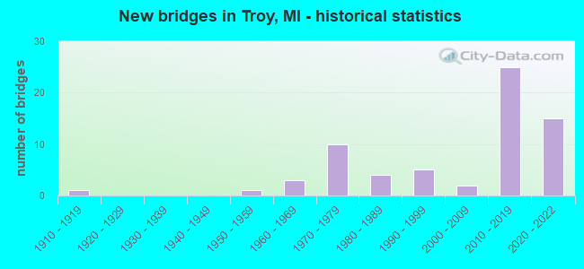
- New bridges - historical statistics
- 11910-1919
- 11950-1959
- 31960-1969
- 101970-1979
- 41980-1989
- 51990-1999
- 22000-2009
- 252010-2019
- 152020-2022
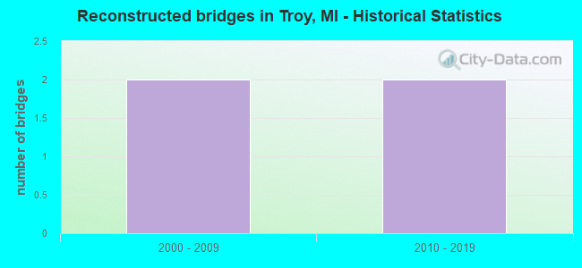
- Reconstructed bridges - Historical Statistics
- 22000-2009
- 22010-2019
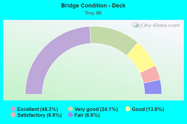
- Bridge Condition - Deck
- 48.3%Excellent
- 24.1%Very good
- 13.8%Good
- 6.9%Satisfactory
- 6.9%Fair
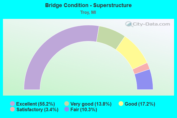
- Bridge Condition - Superstructure
- 55.2%Excellent
- 13.8%Very good
- 17.2%Good
- 3.4%Satisfactory
- 10.3%Fair
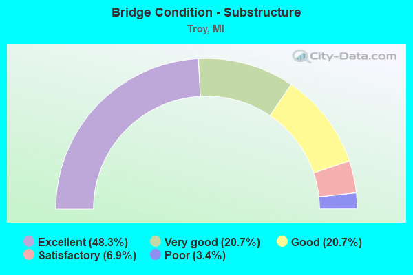
- Bridge Condition - Substructure
- 48.3%Excellent
- 20.7%Very good
- 20.7%Good
- 6.9%Satisfactory
- 3.4%Poor
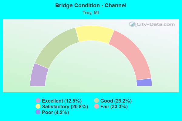
- Bridge Condition - Channel
- 12.5%Excellent
- 29.2%Good
- 20.8%Satisfactory
- 33.3%Fair
- 4.2%Poor
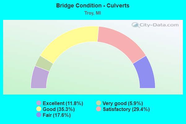
- Bridge Condition - Culverts
- 11.8%Excellent
- 5.9%Very good
- 35.3%Good
- 29.4%Satisfactory
- 17.6%Fair
Find on map >> Show street view
Structure Number: 81, Location: 3 MI N OF DEERTON & M-28 (Lat: 46.516028, Lng: -87.025722), Route carried "on" structure: Other road , Year Built: 1999, Status: Posted for load, Structure Length: 0.94m (3.08ft), Average Daily Traffic: 50 (year 1991), Average Future Daily Traffic: 75 (year 2011), Features Intersected: LAUGHING WHITEFISH RIVER, Facility Carried by Structure: RISKU ROAD
Minimum Vertical Clearance: 30.48m (100.00ft), Kilometerpoint: 1.798, Lanes on structure: 2, Owner: County Highway Agency, Approaching Roadway Width: 5.4m (17.7ft), Material/Design: Steel, Design/Construction: Stringer/Multi-beam, Number Of Spans In Main Unit: 1, Length of Maximum Span: 8.2m (26.9ft), Curb-To-Curb Width: 4.2m (13.8ft), Out-to-Out Width: 4.3m (14.1ft)
Condition: Deck: Satisfactory, Superstructure: Good, Substructure: Good, Channel: Good, Operating Rating: 17.2 metric tons, Method Used To Determine Operating Rating: Load Factor (LF) rating reported by rating factor (RF) method using MS18 loading, Inventory Rating: 13.0 metric tons, Method Used To Determine Inventory Rating: Load Factor (LF) rating reported by rating factor (RF) method using MS18 loading, Structural Evaluation: Meets minimum limits, Waterway Adequacy: Equal to present minimum criteria, Approach Roadway Alignment: Meets minimum limits, Bridge Posting: Required (Relationship of Operating Rating to Maximum Legal Load: > 39.9% below), Length Of Structure Improvement: 1.52m (4.99ft), Designated Inspection Frequency: Every 24 months, Inspection Date: September 2021, Bridge Improvement Cost: $143,000, Roadway Improvement Cost: $17,000, Total Project Cost: $200,000, Deck Structure Type: Wood or Timber, Wearing Surface/Protective System: Wearing Surface: Wood or Timber
Find on map >> Show street view
Structure Number: 808, Location: 2.0 MI NE OF HARBERT (Lat: 41.885564, Lng: -86.601236), Route carried "on" structure: Interstate 94, Year Built: 1961, Year Reconstructed: 2006, Status: Open, Structure Length: 4.50m (14.76ft), Average Daily Traffic: 18,373 (year 2007), Truck Traffic: 31%, Average Future Daily Traffic: 24,900 (year 2025), Design Load: HS 20, Features Intersected: SAWYER ROAD
Minimum Vertical Clearance: 30.48m (100.00ft), Kilometerpoint: 19.334, Lanes on structure: 4, Lanes under structure: 4, Base Highway Network: Yes (Inventory Route: 136, Subroute: 2), Owner: State Highway Agency, Approaching Roadway Width: 19.5m (64.0ft), Skew: 1 degrees, Material/Design: Steel, Design/Construction: Stringer/Multi-beam, Number Of Spans In Main Unit: 3, Length of Maximum Span: 19.8m (65.0ft), Curb-To-Curb Width: 20.7m (67.9ft), Out-to-Out Width: 21.6m (70.9ft)
Condition: Deck: Good, Superstructure: Fair, Substructure: Satisfactory, Operating Rating: 84.6 metric tons, Method Used To Determine Operating Rating: Load Factor (LF), Inventory Rating: 50.8 metric tons, Method Used To Determine Inventory Rating: Load Factor (LF), Structural Evaluation: Somewhat better than minimum adequacy, Deck Geometry: Equal to present minimum criteria, Underclear: Somewhat better than minimum adequacy, Approach Roadway Alignment: Equal to present desirable criteria, Designated Inspection Frequency: Every 24 months, Inspection Date: July 2020, Deck Structure Type: Concrete Cast-file-Place, Wearing Surface/Protective System: Wearing Surface: Monolithic Concrete, Deck Protection: Epoxy Coated Reinforcing
Find on map >> Show street view
Structure Number: 809, Location: 2.0 MI S OF BRIDGEMAN (Lat: 41.899636, Lng: -86.589417), Route carried "on" structure: County highway , Year Built: 1961, Status: Open, Structure Length: 7.43m (24.38ft), Average Daily Traffic: 627 (year 1984), Truck Traffic: 3%, Average Future Daily Traffic: 721 (year 2004), Design Load: H 15, Features Intersected: I-94, Facility Carried by Structure: BROWNTOWN ROAD
Minimum Vertical Clearance: 30.48m (100.00ft), Kilometerpoint: 1.643, Lanes on structure: 2, Lanes under structure: 6, Owner: State Highway Agency, Approaching Roadway Width: 6.9m (22.6ft), Skew: 2 degrees, Material/Design: Steel, Design/Construction: Stringer/Multi-beam, Number Of Spans In Main Unit: 4, Length of Maximum Span: 25.6m (84.0ft), Curb-To-Curb Width: 8.9m (29.2ft), Out-to-Out Width: 10.0m (32.8ft)
Condition: Deck: Fair, Superstructure: Fair, Substructure: Satisfactory, Operating Rating: 64.5 metric tons, Method Used To Determine Operating Rating: Load Factor (LF) rating reported by rating factor (RF) method using MS18 loading, Inventory Rating: 33.0 metric tons, Method Used To Determine Inventory Rating: Load Factor (LF) rating reported by rating factor (RF) method using MS18 loading, Structural Evaluation: Somewhat better than minimum adequacy, Deck Geometry: Somewhat better than minimum adequacy, Underclear: High priority of corrective action, Approach Roadway Alignment: Equal to present minimum criteria, Designated Inspection Frequency: Every 24 months, Inspection Date: July 2020, Deck Structure Type: Concrete Cast-file-Place, Wearing Surface/Protective System: Wearing Surface: Latex Concrete
Find on map >> Show street view
Structure Number: 1361, Location: 5 MI N OF TEKONSHA (Lat: 42.174050, Lng: -84.995942), Route carried "on" structure: County highway , Year Built: 1919, Status: Posted for load, Structure Length: 0.76m (2.49ft), Average Daily Traffic: 43 (year 1994), Truck Traffic: 5%, Average Future Daily Traffic: 80 (year 2024), Design Load: H 10, Features Intersected: NOTTAWA CREEK, Facility Carried by Structure: J DRIVE SOUTH
Minimum Vertical Clearance: 30.48m (100.00ft), Kilometerpoint: 1.260, Lanes on structure: 2, Owner: County Highway Agency, Approaching Roadway Width: 5.5m (18.0ft), Material/Design: Steel, Design/Construction: Stringer/Multi-beam, Number Of Spans In Main Unit: 1, Length of Maximum Span: 7.6m (24.9ft), Curb-To-Curb Width: 4.9m (16.1ft), Out-to-Out Width: 5.3m (17.4ft)
Condition: Deck: Fair, Superstructure: Fair, Substructure: Poor, Channel: Fair, Operating Rating: 32.1 metric tons, Method Used To Determine Operating Rating: Load Factor (LF) rating reported by rating factor (RF) method using MS18 loading, Inventory Rating: 19.1 metric tons, Method Used To Determine Inventory Rating: Load Factor (LF) rating reported by rating factor (RF) method using MS18 loading, Structural Evaluation: Meets minimum limits, Deck Geometry: High priority of corrective action, Waterway Adequacy: Equal to present desirable criteria, Approach Roadway Alignment: Equal to present desirable criteria, Bridge Posting: Required (Relationship of Operating Rating to Maximum Legal Load: 30.0 - 39.9% below), Length Of Structure Improvement: 1.34m (4.40ft), Designated Inspection Frequency: Every 12 months, Inspection Date: September 2021, Bridge Improvement Cost: $123,000, Roadway Improvement Cost: $95,000, Total Project Cost: $218,000, Deck Structure Type: Concrete Cast-file-Place, Wearing Surface/Protective System: Wearing Surface: Monolithic Concrete
Find on map >> Show street view
Structure Number: 7986, Location: 2.7 MI N OF BIG BEAVER RD (Lat: 42.599875, Lng: -83.129414), Route carried "on" structure: City street , Year Built: 1979, Status: Open, Structure Length: 0.70m (2.30ft), Average Daily Traffic: 40,331 (year 1997), Truck Traffic: 8%, Average Future Daily Traffic: 49,000 (year 2010), Design Load: HS 20, Features Intersected: RENSHAW COUNTY DRAIN, Facility Carried by Structure: ROCHESTER RD
Minimum Vertical Clearance: 30.48m (100.00ft), Kilometerpoint: 11.591, Lanes on structure: 6, Base Highway Network: Yes (Inventory Route: 441, Subroute: 38), Owner: City or Municipal Highway Agency, Approaching Roadway Width: 20.1m (65.9ft), Skew: 1 degrees, Material/Design: Concrete, Design/Construction: Culvert, Number Of Spans In Main Unit: 2, Length of Maximum Span: 3.0m (9.8ft), Out-to-Out Width: 61.0m (200.1ft)
Condition: Channel: Fair, Culverts: Satisfactory, Operating Rating: 54.6 metric tons, Method Used To Determine Operating Rating: Field evaluation and documented engineering judgment, Inventory Rating: 32.7 metric tons, Method Used To Determine Inventory Rating: Field evaluation and documented engineering judgment, Structural Evaluation: Equal to present minimum criteria, Waterway Adequacy: Equal to present minimum criteria, Approach Roadway Alignment: Equal to present desirable criteria, Designated Inspection Frequency: Every 24 months, Inspection Date: April 2021
Find on map >> Show street view
Structure Number: 7987, Location: 2.8 MI N OF BIG BEAVER RD (Lat: 42.605103, Lng: -83.129692), Route carried "on" structure: City street , Year Built: 1979, Status: Open, Structure Length: 0.69m (2.26ft), Average Daily Traffic: 42,000 (year 1993), Truck Traffic: 8%, Average Future Daily Traffic: 48,000 (year 2010), Design Load: HS 20, Features Intersected: RENSHAW COUNTY DRAIN, Facility Carried by Structure: ROCHESTER RD
Minimum Vertical Clearance: 30.48m (100.00ft), Kilometerpoint: 12.172, Lanes on structure: 2, Base Highway Network: Yes (Inventory Route: 441, Subroute: 38), Owner: City or Municipal Highway Agency, Approaching Roadway Width: 11.0m (36.1ft), Material/Design: Concrete, Design/Construction: Culvert, Number Of Spans In Main Unit: 2, Length of Maximum Span: 3.0m (9.8ft), Curb or Sidewalk Widths: Left: 1.5m (4.9ft), Right: 1.5m (4.9ft), Curb-To-Curb Width: 11.0m (36.1ft), Out-to-Out Width: 46.0m (150.9ft)
Condition: Channel: Fair, Culverts: Satisfactory, Operating Rating: 54.6 metric tons, Method Used To Determine Operating Rating: Field evaluation and documented engineering judgment, Inventory Rating: 32.7 metric tons, Method Used To Determine Inventory Rating: Field evaluation and documented engineering judgment, Structural Evaluation: Equal to present minimum criteria, Deck Geometry: Meets minimum limits, Waterway Adequacy: Equal to present minimum criteria, Approach Roadway Alignment: Equal to present desirable criteria, Designated Inspection Frequency: Every 24 months, Inspection Date: April 2021, Wearing Surface/Protective System: Wearing Surface: Monolithic Concrete
Find on map >> Show street view
Structure Number: 8046, Location: 0.5 MI EAST OF COOLIDGE (Lat: 42.605192, Lng: -83.179464), Route carried "on" structure: Interstate 75, Year Built: 2020, Status: Open, Structure Length: 0.91m (2.99ft), Average Daily Traffic: 105,868 (year 2007), Truck Traffic: 8%, Average Future Daily Traffic: 112,439 (year 2018), Design Load: Greater than HL93, Features Intersected: ROUGE RIVER (SPRAGUE DR)
Minimum Vertical Clearance: 30.48m (100.00ft), Kilometerpoint: 22.248, Lanes on structure: 8, Base Highway Network: Yes (Inventory Route: 64, Subroute: 8), Owner: State Highway Agency, Approaching Roadway Width: 43.1m (141.4ft), Skew: 2 degrees, Material/Design: Concrete, Design/Construction: Culvert, Number Of Spans In Main Unit: 1, Length of Maximum Span: 9.1m (29.9ft), Curb-To-Curb Width: 43.1m (141.4ft), Out-to-Out Width: 64.9m (212.9ft)
Condition: Channel: Good, Culverts: Excellent, Operating Rating: 97.2 metric tons, Method Used To Determine Operating Rating: Load and Resistance Factor Rating (LRFR) rating reported by rating factor(RF) method using HL-93 loadings, Inventory Rating: 85.5 metric tons, Method Used To Determine Inventory Rating: Load and Resistance Factor Rating (LRFR) rating reported by rating factor(RF) method using HL-93 loadings, Structural Evaluation: Superior to present desirable criteria, Deck Geometry: Superior to present desirable criteria, Waterway Adequacy: Equal to present minimum criteria, Approach Roadway Alignment: Equal to present minimum criteria, Designated Inspection Frequency: Every 24 months, Inspection Date: September 2020, Wearing Surface/Protective System: Wearing Surface: Low Slump Concrete
Find on map >> Show street view
Structure Number: 8064, Location: IN TROY (Lat: 42.559608, Lng: -83.129542), Route carried "on" structure: Interstate 75, Year Built: 2019, Status: Open, Structure Length: 5.74m (18.83ft), Average Daily Traffic: 65,985 (year 2007), Truck Traffic: 8%, Average Future Daily Traffic: 73,450 (year 2029), Design Load: Greater than HL93, Features Intersected: M-150 (ROCHESTER RD)
Minimum Vertical Clearance: 30.48m (100.00ft), Kilometerpoint: 13.870, Lanes on structure: 5, Lanes under structure: 7, Base Highway Network: Yes (Inventory Route: 64, Subroute: 8), Owner: State Highway Agency, Approaching Roadway Width: 25.1m (82.3ft), Material/Design: Prestressed concrete, Design/Construction: Stringer/Multi-beam, Number Of Spans In Main Unit: 2, Length of Maximum Span: 27.9m (91.5ft), Curb-To-Curb Width: 25.1m (82.3ft), Out-to-Out Width: 26.7m (87.6ft)
Condition: Deck: Excellent, Superstructure: Excellent, Substructure: Excellent, Operating Rating: 68.7 metric tons, Method Used To Determine Operating Rating: Load and Resistance Factor Rating (LRFR) rating reported by rating factor(RF) method using HL-93 loadings, Inventory Rating: 39.2 metric tons, Method Used To Determine Inventory Rating: Load and Resistance Factor Rating (LRFR) rating reported by rating factor(RF) method using HL-93 loadings, Structural Evaluation: Superior to present desirable criteria, Deck Geometry: Better than present minimum criteria, Underclear: Better than present minimum criteria, Approach Roadway Alignment: Equal to present desirable criteria, Designated Inspection Frequency: Every 24 months, Inspection Date: September 2021, Deck Structure Type: Concrete Cast-file-Place, Wearing Surface/Protective System: Wearing Surface: Monolithic Concrete, Deck Protection: Epoxy Coated Reinforcing
Find on map >> Show street view
Structure Number: 8065, Location: IN TROY (Lat: 42.559364, Lng: -83.129564), Route carried "on" structure: Interstate 75, Year Built: 2020, Status: Open, Structure Length: 5.74m (18.83ft), Average Daily Traffic: 79,250 (year 2016), Truck Traffic: 8%, Average Future Daily Traffic: 96,100 (year 2036), Design Load: Greater than HL93, Features Intersected: M-150 (ROCHESTER RD.)
Minimum Vertical Clearance: 30.48m (100.00ft), Kilometerpoint: 13.831, Lanes on structure: 5, Lanes under structure: 6, Base Highway Network: Yes (Inventory Route: 64, Subroute: 6), Owner: State Highway Agency, Approaching Roadway Width: 25.1m (82.3ft), Material/Design: Prestressed concrete, Design/Construction: Stringer/Multi-beam, Number Of Spans In Main Unit: 2, Length of Maximum Span: 27.9m (91.5ft), Curb-To-Curb Width: 25.2m (82.7ft), Out-to-Out Width: 26.2m (86.0ft)
Condition: Deck: Excellent, Superstructure: Excellent, Substructure: Excellent, Operating Rating: 69.3 metric tons, Method Used To Determine Operating Rating: Load and Resistance Factor Rating (LRFR) rating reported by rating factor(RF) method using HL-93 loadings, Inventory Rating: 39.9 metric tons, Method Used To Determine Inventory Rating: Load and Resistance Factor Rating (LRFR) rating reported by rating factor(RF) method using HL-93 loadings, Structural Evaluation: Superior to present desirable criteria, Deck Geometry: Better than present minimum criteria, Underclear: Better than present minimum criteria, Approach Roadway Alignment: Equal to present desirable criteria, Designated Inspection Frequency: Every 12 months, Inspection Date: September 2021, Deck Structure Type: Concrete Cast-file-Place, Wearing Surface/Protective System: Wearing Surface: Monolithic Concrete, Deck Protection: Epoxy Coated Reinforcing
Find on map >> Show street view
Structure Number: 8066, Location: IN TROY (Lat: 42.559164, Lng: -83.147514), Route carried "on" structure: Interstate 75, Year Built: 2019, Status: Open, Structure Length: 3.92m (12.86ft), Average Daily Traffic: 53,550 (year 2013), Truck Traffic: 6%, Average Future Daily Traffic: 61,583 (year 2033), Design Load: Greater than HL93, Features Intersected: LIVERNOIS RD
Minimum Vertical Clearance: 30.48m (100.00ft), Kilometerpoint: 15.355, Lanes on structure: 4, Lanes under structure: 4, Base Highway Network: Yes (Inventory Route: 64, Subroute: 8), Owner: State Highway Agency, Approaching Roadway Width: 21.5m (70.5ft), Material/Design: Prestressed concrete, Design/Construction: Stringer/Multi-beam, Number Of Spans In Main Unit: 1, Length of Maximum Span: 38.4m (126.0ft), Curb-To-Curb Width: 21.5m (70.5ft), Out-to-Out Width: 22.5m (73.8ft)
Condition: Deck: Excellent, Superstructure: Excellent, Substructure: Excellent, Operating Rating: 76.5 metric tons, Method Used To Determine Operating Rating: Load and Resistance Factor Rating (LRFR) rating reported by rating factor(RF) method using HL-93 loadings, Inventory Rating: 40.8 metric tons, Method Used To Determine Inventory Rating: Load and Resistance Factor Rating (LRFR) rating reported by rating factor(RF) method using HL-93 loadings, Structural Evaluation: Superior to present desirable criteria, Deck Geometry: Better than present minimum criteria, Underclear: Better than present minimum criteria, Approach Roadway Alignment: Equal to present desirable criteria, Designated Inspection Frequency: Every 24 months, Inspection Date: December 2021, Deck Structure Type: Concrete Cast-file-Place, Wearing Surface/Protective System: Wearing Surface: Monolithic Concrete, Deck Protection: Epoxy Coated Reinforcing
Find on map >> Show street view
Structure Number: 8067, Location: IN TROY (Lat: 42.558942, Lng: -83.147506), Route carried "on" structure: Interstate 75, Year Built: 2020, Status: Open, Structure Length: 3.92m (12.86ft), Average Daily Traffic: 79,250 (year 2016), Truck Traffic: 8%, Average Future Daily Traffic: 96,100 (year 2038), Design Load: Greater than HL93, Features Intersected: LIVERNOIS RD
Minimum Vertical Clearance: 30.48m (100.00ft), Kilometerpoint: 15.313, Lanes on structure: 4, Lanes under structure: 4, Base Highway Network: Yes (Inventory Route: 64, Subroute: 6), Owner: State Highway Agency, Approaching Roadway Width: 21.5m (70.5ft), Material/Design: Prestressed concrete, Design/Construction: Stringer/Multi-beam, Number Of Spans In Main Unit: 1, Length of Maximum Span: 38.4m (126.0ft), Curb-To-Curb Width: 21.5m (70.5ft), Out-to-Out Width: 22.5m (73.8ft)
Condition: Deck: Excellent, Superstructure: Excellent, Substructure: Excellent, Operating Rating: 76.5 metric tons, Method Used To Determine Operating Rating: Load and Resistance Factor Rating (LRFR) rating reported by rating factor(RF) method using HL-93 loadings, Inventory Rating: 40.8 metric tons, Method Used To Determine Inventory Rating: Load and Resistance Factor Rating (LRFR) rating reported by rating factor(RF) method using HL-93 loadings, Structural Evaluation: Superior to present desirable criteria, Deck Geometry: Better than present minimum criteria, Underclear: Better than present minimum criteria, Approach Roadway Alignment: Equal to present desirable criteria, Designated Inspection Frequency: Every 24 months, Inspection Date: December 2021, Deck Structure Type: Concrete Cast-file-Place, Wearing Surface/Protective System: Wearing Surface: Monolithic Concrete, Deck Protection: Epoxy Coated Reinforcing
Find on map >> Show street view
Structure Number: 8068, Location: IN TROY (Lat: 42.562097, Lng: -83.158025), Route carried "on" structure: Interstate 75, Year Built: 2019, Status: Open, Structure Length: 7.05m (23.13ft), Average Daily Traffic: 56,557 (year 2007), Truck Traffic: 8%, Average Future Daily Traffic: 58,600 (year 2029), Design Load: Greater than HL93, Features Intersected: BIG BEAVER RD
Minimum Vertical Clearance: 30.48m (100.00ft), Kilometerpoint: 16.366, Lanes on structure: 4, Lanes under structure: 7, Base Highway Network: Yes (Inventory Route: 64, Subroute: 8), Owner: State Highway Agency, Approaching Roadway Width: 19.5m (64.0ft), Skew: 2 degrees, Material/Design: Prestressed concrete, Design/Construction: Stringer/Multi-beam, Number Of Spans In Main Unit: 2, Length of Maximum Span: 34.0m (111.5ft), Curb-To-Curb Width: 19.5m (64.0ft), Out-to-Out Width: 20.6m (67.6ft)
Condition: Deck: Excellent, Superstructure: Excellent, Substructure: Excellent, Operating Rating: 63.8 metric tons, Method Used To Determine Operating Rating: Load and Resistance Factor Rating (LRFR) rating reported by rating factor(RF) method using HL-93 loadings, Inventory Rating: 36.9 metric tons, Method Used To Determine Inventory Rating: Load and Resistance Factor Rating (LRFR) rating reported by rating factor(RF) method using HL-93 loadings, Structural Evaluation: Superior to present desirable criteria, Deck Geometry: Somewhat better than minimum adequacy, Underclear: Equal to present minimum criteria, Approach Roadway Alignment: Equal to present desirable criteria, Designated Inspection Frequency: Every 24 months, Inspection Date: July 2021, Deck Structure Type: Concrete Cast-file-Place, Wearing Surface/Protective System: Wearing Surface: Monolithic Concrete, Deck Protection: Epoxy Coated Reinforcing
Find on map >> Show street view
Structure Number: 8069, Location: IN TROY (Lat: 42.562081, Lng: -83.158350), Route carried "on" structure: Interstate 75, Year Built: 2020, Status: Open, Structure Length: 7.01m (23.00ft), Average Daily Traffic: 79,250 (year 2016), Truck Traffic: 8%, Average Future Daily Traffic: 96,100 (year 2038), Design Load: Greater than HL93, Features Intersected: BIG BEAVER RD
Minimum Vertical Clearance: 30.48m (100.00ft), Kilometerpoint: 16.361, Lanes on structure: 4, Lanes under structure: 7, Base Highway Network: Yes (Inventory Route: 64, Subroute: 6), Owner: State Highway Agency, Approaching Roadway Width: 21.5m (70.5ft), Skew: 2 degrees, Material/Design: Prestressed concrete, Design/Construction: Stringer/Multi-beam, Number Of Spans In Main Unit: 2, Length of Maximum Span: 34.6m (113.5ft), Curb-To-Curb Width: 23.4m (76.8ft), Out-to-Out Width: 24.4m (80.1ft)
Condition: Deck: Excellent, Superstructure: Excellent, Substructure: Excellent, Operating Rating: 62.5 metric tons, Method Used To Determine Operating Rating: Load and Resistance Factor Rating (LRFR) rating reported by rating factor(RF) method using HL-93 loadings, Inventory Rating: 37.3 metric tons, Method Used To Determine Inventory Rating: Load and Resistance Factor Rating (LRFR) rating reported by rating factor(RF) method using HL-93 loadings, Structural Evaluation: Superior to present desirable criteria, Deck Geometry: Superior to present desirable criteria, Underclear: Equal to present minimum criteria, Approach Roadway Alignment: Equal to present desirable criteria, Designated Inspection Frequency: Every 24 months, Inspection Date: July 2021, Deck Structure Type: Concrete Cast-file-Place, Wearing Surface/Protective System: Wearing Surface: Monolithic Concrete, Deck Protection: Epoxy Coated Reinforcing
Find on map >> Show street view
Structure Number: 8072, Location: IN TROY (Lat: 42.576983, Lng: -83.158961), Route carried "on" structure: City street 2059, Year Built: 2019, Status: Open, Structure Length: 5.56m (18.24ft), Average Daily Traffic: 123,600 (year 2008), Truck Traffic: 3%, Average Future Daily Traffic: 152,300 (year 2029), Design Load: Greater than HL93, Features Intersected: I-75, Facility Carried by Structure: WATTLES RD
Minimum Vertical Clearance: 30.48m (100.00ft), Kilometerpoint: 5.396, Lanes on structure: 2, Lanes under structure: 8, Owner: State Highway Agency, Approaching Roadway Width: 10.3m (33.8ft), Material/Design: Prestressed concrete, Design/Construction: Stringer/Multi-beam, Number Of Spans In Main Unit: 2, Length of Maximum Span: 29.7m (97.4ft), Curb or Sidewalk Widths: Left: 3.0m (9.8ft), Right: 3.0m (9.8ft), Curb-To-Curb Width: 13.4m (44.0ft), Out-to-Out Width: 21.0m (68.9ft)
Condition: Deck: Excellent, Superstructure: Excellent, Substructure: Excellent, Operating Rating: 56.4 metric tons, Method Used To Determine Operating Rating: Load and Resistance Factor Rating (LRFR) rating reported by rating factor(RF) method using HL-93 loadings, Inventory Rating: 43.4 metric tons, Method Used To Determine Inventory Rating: Load and Resistance Factor Rating (LRFR) rating reported by rating factor(RF) method using HL-93 loadings, Structural Evaluation: Superior to present desirable criteria, Deck Geometry: Equal to present minimum criteria, Underclear: High priority of corrective action, Approach Roadway Alignment: Equal to present desirable criteria, Designated Inspection Frequency: Every 24 months, Inspection Date: September 2021, Deck Structure Type: Concrete Cast-file-Place, Wearing Surface/Protective System: Wearing Surface: Monolithic Concrete, Deck Protection: Epoxy Coated Reinforcing
Find on map >> Show street view
Structure Number: 8073, Location: IN TROY (Lat: 42.591253, Lng: -83.159269), Route carried "on" structure: Interstate 75, Year Built: 2019, Status: Open, Structure Length: 4.22m (13.85ft), Average Daily Traffic: 56,557 (year 2007), Truck Traffic: 7%, Average Future Daily Traffic: 76,150 (year 2029), Design Load: Greater than HL93, Features Intersected: EAST LONG LAKE RD
Minimum Vertical Clearance: 30.48m (100.00ft), Kilometerpoint: 19.601, Lanes on structure: 4, Lanes under structure: 4, Base Highway Network: Yes (Inventory Route: 64, Subroute: 8), Owner: State Highway Agency, Approaching Roadway Width: 21.5m (70.5ft), Material/Design: Prestressed concrete, Design/Construction: Stringer/Multi-beam, Number Of Spans In Main Unit: 1, Length of Maximum Span: 41.5m (136.2ft), Curb-To-Curb Width: 21.5m (70.5ft), Out-to-Out Width: 22.5m (73.8ft)
Condition: Deck: Excellent, Superstructure: Excellent, Substructure: Excellent, Operating Rating: 71.0 metric tons, Method Used To Determine Operating Rating: Load and Resistance Factor Rating (LRFR) rating reported by rating factor(RF) method using HL-93 loadings, Inventory Rating: 33.4 metric tons, Method Used To Determine Inventory Rating: Load and Resistance Factor Rating (LRFR) rating reported by rating factor(RF) method using HL-93 loadings, Structural Evaluation: Superior to present desirable criteria, Deck Geometry: Better than present minimum criteria, Underclear: Better than present minimum criteria, Approach Roadway Alignment: Equal to present desirable criteria, Designated Inspection Frequency: Every 24 months, Inspection Date: July 2021, Deck Structure Type: Concrete Cast-file-Place, Wearing Surface/Protective System: Wearing Surface: Monolithic Concrete, Deck Protection: Epoxy Coated Reinforcing
Find on map >> Show street view
Structure Number: 8074, Location: IN TROY (Lat: 42.591244, Lng: -83.159581), Route carried "on" structure: Interstate 75, Year Built: 2020, Status: Open, Structure Length: 4.22m (13.85ft), Average Daily Traffic: 79,250 (year 2016), Truck Traffic: 8%, Average Future Daily Traffic: 96,100 (year 2038), Design Load: Greater than HL93, Features Intersected: EAST LONG LAKE RD
Minimum Vertical Clearance: 30.48m (100.00ft), Kilometerpoint: 19.596, Lanes on structure: 4, Lanes under structure: 4, Base Highway Network: Yes (Inventory Route: 64, Subroute: 6), Owner: State Highway Agency, Approaching Roadway Width: 21.5m (70.5ft), Material/Design: Prestressed concrete, Design/Construction: Stringer/Multi-beam, Number Of Spans In Main Unit: 1, Length of Maximum Span: 41.5m (136.2ft), Curb-To-Curb Width: 21.5m (70.5ft), Out-to-Out Width: 22.5m (73.8ft)
Condition: Deck: Excellent, Superstructure: Excellent, Substructure: Excellent, Operating Rating: 72.3 metric tons, Method Used To Determine Operating Rating: Load and Resistance Factor Rating (LRFR) rating reported by rating factor(RF) method using HL-93 loadings, Inventory Rating: 35.3 metric tons, Method Used To Determine Inventory Rating: Load and Resistance Factor Rating (LRFR) rating reported by rating factor(RF) method using HL-93 loadings, Structural Evaluation: Superior to present desirable criteria, Deck Geometry: Better than present minimum criteria, Underclear: Better than present minimum criteria, Approach Roadway Alignment: Better than present minimum criteria, Designated Inspection Frequency: Every 24 months, Inspection Date: July 2021, Deck Structure Type: Concrete Cast-file-Place, Wearing Surface/Protective System: Wearing Surface: Monolithic Concrete, Deck Protection: Epoxy Coated Reinforcing
Find on map >> Show street view
Structure Number: 8075, Location: IN TROY (Lat: 42.599533, Lng: -83.162544), Route carried "on" structure: Ramp Interstate 75, Year Built: 2019, Status: Open, Structure Length: 6.31m (20.70ft), Average Daily Traffic: 123,600 (year 2008), Truck Traffic: 7%, Average Future Daily Traffic: 152,300 (year 2029), Design Load: Greater than HL93, Features Intersected: I-75
Minimum Vertical Clearance: 30.48m (100.00ft), Kilometerpoint: 0.708, Lanes on structure: 2, Lanes under structure: 9, Owner: State Highway Agency, Approaching Roadway Width: 7.9m (25.9ft), Skew: 20 degrees, Material/Design: Prestressed concrete, Design/Construction: Stringer/Multi-beam, Number Of Spans In Main Unit: 2, Length of Maximum Span: 32.4m (106.3ft), Curb-To-Curb Width: 14.6m (47.9ft), Out-to-Out Width: 16.9m (55.4ft)
Condition: Deck: Excellent, Superstructure: Excellent, Substructure: Excellent, Operating Rating: 55.1 metric tons, Method Used To Determine Operating Rating: Load and Resistance Factor Rating (LRFR) rating reported by rating factor(RF) method using HL-93 loadings, Inventory Rating: 37.6 metric tons, Method Used To Determine Inventory Rating: Load and Resistance Factor Rating (LRFR) rating reported by rating factor(RF) method using HL-93 loadings, Structural Evaluation: Superior to present desirable criteria, Deck Geometry: Superior to present desirable criteria, Underclear: Somewhat better than minimum adequacy, Approach Roadway Alignment: Equal to present desirable criteria, Designated Inspection Frequency: Every 24 months, Inspection Date: September 2021, Deck Structure Type: Concrete Cast-file-Place, Wearing Surface/Protective System: Wearing Surface: Monolithic Concrete, Deck Protection: Epoxy Coated Reinforcing
Find on map >> Show street view
Structure Number: 8076, Location: IN TROY (Lat: 42.604522, Lng: -83.168997), Route carried "on" structure: County highway 2059, Year Built: 1990, Status: Open, Structure Length: 8.59m (28.18ft), Average Daily Traffic: 21,500 (year 1990), Truck Traffic: 3%, Average Future Daily Traffic: 21,500 (year 2010), Design Load: H 20, Features Intersected: I-75, Facility Carried by Structure: NB CROOKS RD
Minimum Vertical Clearance: 30.48m (100.00ft), Kilometerpoint: 12.341, Lanes on structure: 3, Lanes under structure: 8, Base Highway Network: Yes (Inventory Route: 65, Subroute: 10), Owner: State Highway Agency, Approaching Roadway Width: 12.2m (40.0ft), Skew: 2 degrees, Material/Design: Steel continuous, Design/Construction: Stringer/Multi-beam, Number Of Spans In Main Unit: 4, Length of Maximum Span: 28.9m (94.8ft), Curb or Sidewalk Widths: Left: 0.0m, Right: 2.4m (7.9ft), Curb-To-Curb Width: 13.4m (44.0ft), Out-to-Out Width: 17.1m (56.1ft)
Condition: Deck: Good, Superstructure: Good, Substructure: Good, Operating Rating: 61.2 metric tons, Method Used To Determine Operating Rating: Load Factor (LF) rating reported by rating factor (RF) method using MS18 loading, Inventory Rating: 36.6 metric tons, Method Used To Determine Inventory Rating: Load Factor (LF) rating reported by rating factor (RF) method using MS18 loading, Structural Evaluation: Better than present minimum criteria, Deck Geometry: Somewhat better than minimum adequacy, Underclear: Equal to present minimum criteria, Approach Roadway Alignment: Equal to present desirable criteria, Designated Inspection Frequency: Every 24 months, Inspection Date: November 2020, Deck Structure Type: Concrete Cast-file-Place, Wearing Surface/Protective System: Wearing Surface: Epoxy Overlay, Deck Protection: Epoxy Coated Reinforcing
Find on map >> Show street view
Structure Number: 8077, Location: IN TROY (Lat: 42.604964, Lng: -83.188828), Route carried "on" structure: Interstate 75, Year Built: 2019, Status: Open, Structure Length: 3.46m (11.35ft), Average Daily Traffic: 52,934 (year 2007), Truck Traffic: 8%, Average Future Daily Traffic: 56,219 (year 2018), Design Load: Greater than HL93, Features Intersected: COOLIDGE RD
Minimum Vertical Clearance: 30.48m (100.00ft), Kilometerpoint: 23.018, Lanes on structure: 4, Lanes under structure: 3, Base Highway Network: Yes (Inventory Route: 64, Subroute: 8), Owner: State Highway Agency, Approaching Roadway Width: 21.5m (70.5ft), Material/Design: Prestressed concrete, Design/Construction: Stringer/Multi-beam, Number Of Spans In Main Unit: 1, Length of Maximum Span: 33.8m (110.9ft), Curb-To-Curb Width: 21.5m (70.5ft), Out-to-Out Width: 22.5m (73.8ft)
Condition: Deck: Very good, Superstructure: Very good, Substructure: Very good, Operating Rating: 62.5 metric tons, Method Used To Determine Operating Rating: Load and Resistance Factor Rating (LRFR) rating reported by rating factor(RF) method using HL-93 loadings, Inventory Rating: 34.7 metric tons, Method Used To Determine Inventory Rating: Load and Resistance Factor Rating (LRFR) rating reported by rating factor(RF) method using HL-93 loadings, Structural Evaluation: Equal to present desirable criteria, Deck Geometry: Better than present minimum criteria, Underclear: High priority of corrective action, Approach Roadway Alignment: Equal to present desirable criteria, Designated Inspection Frequency: Every 24 months, Inspection Date: July 2021, Deck Structure Type: Concrete Cast-file-Place, Wearing Surface/Protective System: Wearing Surface: Monolithic Concrete, Deck Protection: Epoxy Coated Reinforcing
Find on map >> Show street view
Structure Number: 8078, Location: IN TROY (Lat: 42.604731, Lng: -83.188828), Route carried "on" structure: Interstate 75, Year Built: 2020, Status: Open, Structure Length: 3.46m (11.35ft), Average Daily Traffic: 79,250 (year 2016), Truck Traffic: 8%, Average Future Daily Traffic: 96,100 (year 2038), Design Load: Greater than HL93, Features Intersected: COOLIDGE RD
Minimum Vertical Clearance: 30.48m (100.00ft), Kilometerpoint: 22.974, Lanes on structure: 4, Lanes under structure: 3, Base Highway Network: Yes (Inventory Route: 64, Subroute: 6), Owner: State Highway Agency, Approaching Roadway Width: 21.5m (70.5ft), Material/Design: Prestressed concrete, Design/Construction: Stringer/Multi-beam, Number Of Spans In Main Unit: 1, Length of Maximum Span: 33.8m (110.9ft), Curb-To-Curb Width: 21.5m (70.5ft), Out-to-Out Width: 22.5m (73.8ft)
Condition: Deck: Very good, Superstructure: Very good, Substructure: Very good, Operating Rating: 63.2 metric tons, Method Used To Determine Operating Rating: Load and Resistance Factor Rating (LRFR) rating reported by rating factor(RF) method using HL-93 loadings, Inventory Rating: 36.0 metric tons, Method Used To Determine Inventory Rating: Load and Resistance Factor Rating (LRFR) rating reported by rating factor(RF) method using HL-93 loadings, Structural Evaluation: Equal to present desirable criteria, Deck Geometry: Better than present minimum criteria, Underclear: High priority of corrective action, Approach Roadway Alignment: Equal to present desirable criteria, Designated Inspection Frequency: Every 24 months, Inspection Date: July 2021, Deck Structure Type: Concrete Cast-file-Place, Wearing Surface/Protective System: Wearing Surface: Monolithic Concrete, Deck Protection: Epoxy Coated Reinforcing
Find on map >> Show street view
Structure Number: 8079, Location: IN TROY (Lat: 42.606083, Lng: -83.205431), Route carried "on" structure: Interstate 75, Year Built: 2017, Status: Open, Structure Length: 4.51m (14.80ft), Average Daily Traffic: 52,934 (year 2007), Truck Traffic: 8%, Average Future Daily Traffic: 56,219 (year 2018), Design Load: Greater than HL93, Features Intersected: SQUARE LAKE RD
Minimum Vertical Clearance: 30.48m (100.00ft), Kilometerpoint: 24.400, Lanes on structure: 4, Lanes under structure: 2, Base Highway Network: Yes (Inventory Route: 64, Subroute: 8), Owner: State Highway Agency, Approaching Roadway Width: 21.5m (70.5ft), Skew: 3 degrees, Material/Design: Prestressed concrete, Design/Construction: Stringer/Multi-beam, Number Of Spans In Main Unit: 1, Length of Maximum Span: 43.6m (143.0ft), Curb-To-Curb Width: 21.5m (70.5ft), Out-to-Out Width: 22.5m (73.8ft)
Condition: Deck: Very good, Superstructure: Good, Substructure: Very good, Operating Rating: 78.7 metric tons, Method Used To Determine Operating Rating: Load and Resistance Factor Rating (LRFR) rating reported by rating factor(RF) method using HL-93 loadings, Inventory Rating: 55.4 metric tons, Method Used To Determine Inventory Rating: Load and Resistance Factor Rating (LRFR) rating reported by rating factor(RF) method using HL-93 loadings, Structural Evaluation: Better than present minimum criteria, Deck Geometry: Better than present minimum criteria, Underclear: Meets minimum limits, Approach Roadway Alignment: Equal to present desirable criteria, Designated Inspection Frequency: Every 24 months, Inspection Date: December 2021, Deck Structure Type: Concrete Cast-file-Place, Wearing Surface/Protective System: Wearing Surface: Monolithic Concrete, Deck Protection: Epoxy Coated Reinforcing
Find on map >> Show street view
Structure Number: 808, Location: IN TROY (Lat: 42.605886, Lng: -83.205703), Route carried "on" structure: Interstate 75, Year Built: 2017, Status: Open, Structure Length: 4.51m (14.80ft), Average Daily Traffic: 52,934 (year 2007), Truck Traffic: 8%, Average Future Daily Traffic: 56,219 (year 2018), Design Load: Greater than HL93, Features Intersected: SQUARE LAKE RD
Minimum Vertical Clearance: 30.48m (100.00ft), Kilometerpoint: 24.379, Lanes on structure: 5, Lanes under structure: 2, Base Highway Network: Yes (Inventory Route: 64, Subroute: 6), Owner: State Highway Agency, Approaching Roadway Width: 16.4m (53.8ft), Skew: 3 degrees, Material/Design: Prestressed concrete, Design/Construction: Stringer/Multi-beam, Number Of Spans In Main Unit: 1, Length of Maximum Span: 43.6m (143.0ft), Curb-To-Curb Width: 25.1m (82.3ft), Out-to-Out Width: 26.2m (86.0ft)
Condition: Deck: Very good, Superstructure: Very good, Substructure: Very good, Operating Rating: 82.0 metric tons, Method Used To Determine Operating Rating: Load and Resistance Factor Rating (LRFR) rating reported by rating factor(RF) method using HL-93 loadings, Inventory Rating: 59.0 metric tons, Method Used To Determine Inventory Rating: Load and Resistance Factor Rating (LRFR) rating reported by rating factor(RF) method using HL-93 loadings, Structural Evaluation: Equal to present desirable criteria, Deck Geometry: Better than present minimum criteria, Underclear: Meets minimum limits, Approach Roadway Alignment: Equal to present desirable criteria, Length Of Structure Improvement: 4.82m (15.81ft), Designated Inspection Frequency: Every 24 months, Inspection Date: December 2021, Bridge Improvement Cost: $177,000, Roadway Improvement Cost: $12,000, Total Project Cost: $140,000, Deck Structure Type: Concrete Cast-file-Place, Wearing Surface/Protective System: Wearing Surface: Monolithic Concrete, Deck Protection: Epoxy Coated Reinforcing
Find on map >> Show street view
Structure Number: 8081, Location: IN TROY (OVER ADAMS RD) (Lat: 42.606767, Lng: -83.208553), Route carried "on" structure: Interstate 75, Year Built: 2017, Status: Open, Structure Length: 4.96m (16.27ft), Average Daily Traffic: 53,391 (year 2007), Truck Traffic: 8%, Average Future Daily Traffic: 56,696 (year 2018), Design Load: Greater than HL93, Features Intersected: ADAMS RD
Minimum Vertical Clearance: 30.48m (100.00ft), Kilometerpoint: 24.667, Lanes on structure: 4, Lanes under structure: 4, Base Highway Network: Yes (Inventory Route: 64, Subroute: 8), Owner: State Highway Agency, Approaching Roadway Width: 16.4m (53.8ft), Skew: 2 degrees, Material/Design: Prestressed concrete, Design/Construction: Stringer/Multi-beam, Number Of Spans In Main Unit: 3, Length of Maximum Span: 26.0m (85.3ft), Curb-To-Curb Width: 24.0m (78.7ft), Out-to-Out Width: 25.1m (82.3ft)
Condition: Deck: Very good, Superstructure: Excellent, Substructure: Very good, Operating Rating: 59.3 metric tons, Method Used To Determine Operating Rating: Load and Resistance Factor Rating (LRFR) rating reported by rating factor(RF) method using HL-93 loadings, Inventory Rating: 41.1 metric tons, Method Used To Determine Inventory Rating: Load and Resistance Factor Rating (LRFR) rating reported by rating factor(RF) method using HL-93 loadings, Structural Evaluation: Equal to present desirable criteria, Deck Geometry: Superior to present desirable criteria, Underclear: Somewhat better than minimum adequacy, Approach Roadway Alignment: Equal to present desirable criteria, Designated Inspection Frequency: Every 24 months, Inspection Date: December 2021, Deck Structure Type: Concrete Cast-file-Place, Wearing Surface/Protective System: Wearing Surface: Monolithic Concrete, Deck Protection: Epoxy Coated Reinforcing
Find on map >> Show street view
Structure Number: 8082, Location: IN TROY (OVER ADAMS RD) (Lat: 42.606511, Lng: -83.208542), Route carried "on" structure: Interstate 75, Year Built: 2017, Status: Open, Structure Length: 4.96m (16.27ft), Average Daily Traffic: 53,391 (year 2007), Truck Traffic: 8%, Average Future Daily Traffic: 56,696 (year 2018), Design Load: Greater than HL93, Features Intersected: ADAMS RD
Minimum Vertical Clearance: 30.48m (100.00ft), Kilometerpoint: 24.622, Lanes on structure: 5, Lanes under structure: 4, Base Highway Network: Yes (Inventory Route: 64, Subroute: 6), Owner: State Highway Agency, Approaching Roadway Width: 16.4m (53.8ft), Skew: 2 degrees, Material/Design: Prestressed concrete, Design/Construction: Stringer/Multi-beam, Number Of Spans In Main Unit: 3, Length of Maximum Span: 26.0m (85.3ft), Curb-To-Curb Width: 27.0m (88.6ft), Out-to-Out Width: 28.0m (91.9ft)
Condition: Deck: Very good, Superstructure: Very good, Substructure: Very good, Operating Rating: 54.1 metric tons, Method Used To Determine Operating Rating: Load and Resistance Factor Rating (LRFR) rating reported by rating factor(RF) method using HL-93 loadings, Inventory Rating: 36.9 metric tons, Method Used To Determine Inventory Rating: Load and Resistance Factor Rating (LRFR) rating reported by rating factor(RF) method using HL-93 loadings, Structural Evaluation: Equal to present desirable criteria, Deck Geometry: Superior to present desirable criteria, Underclear: Somewhat better than minimum adequacy, Approach Roadway Alignment: Equal to present desirable criteria, Designated Inspection Frequency: Every 24 months, Inspection Date: December 2021, Deck Structure Type: Concrete Cast-file-Place, Wearing Surface/Protective System: Wearing Surface: Monolithic Concrete, Deck Protection: Epoxy Coated Reinforcing
Find on map >> Show street view
Structure Number: 8089, Location: IN TROY (OVER MAPLE RD) (Lat: 42.548986, Lng: -83.116586), Route carried "on" structure: Interstate 75, Year Built: 2019, Status: Open, Structure Length: 3.46m (11.35ft), Average Daily Traffic: 65,985 (year 2007), Truck Traffic: 7%, Average Future Daily Traffic: 76,150 (year 2029), Design Load: Greater than HL93, Features Intersected: MAPLE RD, 15 MILE RD
Minimum Vertical Clearance: 30.48m (100.00ft), Kilometerpoint: 11.972, Lanes on structure: 4, Lanes under structure: 4, Base Highway Network: Yes (Inventory Route: 64, Subroute: 8), Owner: State Highway Agency, Approaching Roadway Width: 21.5m (70.5ft), Material/Design: Prestressed concrete, Design/Construction: Stringer/Multi-beam, Number Of Spans In Main Unit: 1, Length of Maximum Span: 33.8m (110.9ft), Curb-To-Curb Width: 21.5m (70.5ft), Out-to-Out Width: 22.5m (73.8ft)
Condition: Deck: Excellent, Superstructure: Excellent, Substructure: Excellent, Operating Rating: 68.7 metric tons, Method Used To Determine Operating Rating: Load and Resistance Factor Rating (LRFR) rating reported by rating factor(RF) method using HL-93 loadings, Inventory Rating: 39.9 metric tons, Method Used To Determine Inventory Rating: Load and Resistance Factor Rating (LRFR) rating reported by rating factor(RF) method using HL-93 loadings, Structural Evaluation: Superior to present desirable criteria, Deck Geometry: Better than present minimum criteria, Underclear: Better than present minimum criteria, Approach Roadway Alignment: Equal to present desirable criteria, Designated Inspection Frequency: Every 24 months, Inspection Date: July 2021, Deck Structure Type: Concrete Cast-file-Place, Wearing Surface/Protective System: Wearing Surface: Monolithic Concrete, Deck Protection: Epoxy Coated Reinforcing
Find on map >> Show street view
Structure Number: 809, Location: IN TROY (OVER MAPLE RD) (Lat: 42.548983, Lng: -83.116900), Route carried "on" structure: Interstate 75, Year Built: 2020, Status: Open, Structure Length: 3.46m (11.35ft), Average Daily Traffic: 79,250 (year 2016), Truck Traffic: 8%, Average Future Daily Traffic: 96,100 (year 2038), Design Load: Greater than HL93, Features Intersected: MAPLE RD, 15 MILE RD
Minimum Vertical Clearance: 30.48m (100.00ft), Kilometerpoint: 11.971, Lanes on structure: 4, Lanes under structure: 4, Base Highway Network: Yes (Inventory Route: 64, Subroute: 6), Owner: State Highway Agency, Approaching Roadway Width: 21.5m (70.5ft), Material/Design: Prestressed concrete, Design/Construction: Stringer/Multi-beam, Number Of Spans In Main Unit: 1, Length of Maximum Span: 33.8m (110.9ft), Curb-To-Curb Width: 21.5m (70.5ft), Out-to-Out Width: 22.5m (73.8ft)
Condition: Deck: Excellent, Superstructure: Excellent, Substructure: Excellent, Operating Rating: 67.4 metric tons, Method Used To Determine Operating Rating: Load and Resistance Factor Rating (LRFR) rating reported by rating factor(RF) method using HL-93 loadings, Inventory Rating: 39.9 metric tons, Method Used To Determine Inventory Rating: Load and Resistance Factor Rating (LRFR) rating reported by rating factor(RF) method using HL-93 loadings, Structural Evaluation: Superior to present desirable criteria, Deck Geometry: Better than present minimum criteria, Underclear: Better than present minimum criteria, Approach Roadway Alignment: Equal to present desirable criteria, Designated Inspection Frequency: Every 24 months, Inspection Date: July 2021, Deck Structure Type: Concrete Cast-file-Place, Wearing Surface/Protective System: Wearing Surface: Monolithic Concrete, Deck Protection: Epoxy Coated Reinforcing
Find on map >> Show street view
Structure Number: 81, Location: IN TROY (Lat: 42.604886, Lng: -83.169350), Route carried "on" structure: County highway 2059, Year Built: 1990, Status: Open, Structure Length: 8.59m (28.18ft), Average Daily Traffic: 21,500 (year 1990), Truck Traffic: 3%, Average Future Daily Traffic: 21,500 (year 2010), Design Load: H 20, Features Intersected: I-75, Facility Carried by Structure: SB CROOKS ROAD
Minimum Vertical Clearance: 30.48m (100.00ft), Kilometerpoint: 2.305, Lanes on structure: 3, Lanes under structure: 8, Base Highway Network: Yes (Inventory Route: 440, Subroute: 39), Owner: State Highway Agency, Approaching Roadway Width: 12.2m (40.0ft), Skew: 2 degrees, Material/Design: Steel continuous, Design/Construction: Stringer/Multi-beam, Number Of Spans In Main Unit: 4, Length of Maximum Span: 28.9m (94.8ft), Curb or Sidewalk Widths: Left: 2.4m (7.9ft), Right: 0.0m, Curb-To-Curb Width: 13.4m (44.0ft), Out-to-Out Width: 17.1m (56.1ft)
Condition: Deck: Good, Superstructure: Good, Substructure: Good, Operating Rating: 66.4 metric tons, Method Used To Determine Operating Rating: Load Factor (LF) rating reported by rating factor (RF) method using MS18 loading, Inventory Rating: 39.9 metric tons, Method Used To Determine Inventory Rating: Load Factor (LF) rating reported by rating factor (RF) method using MS18 loading, Structural Evaluation: Better than present minimum criteria, Deck Geometry: Somewhat better than minimum adequacy, Underclear: Equal to present minimum criteria, Approach Roadway Alignment: Equal to present desirable criteria, Designated Inspection Frequency: Every 24 months, Inspection Date: November 2020, Deck Structure Type: Concrete Cast-file-Place, Wearing Surface/Protective System: Wearing Surface: Epoxy Overlay, Deck Protection: Epoxy Coated Reinforcing
Find on map >> Show street view
Structure Number: 8157, Location: BET FOURTEEN AND MAPLE (Lat: 42.545439, Lng: -83.107531), Route carried "on" structure: County highway 2059, Year Built: 1976, Status: Open, Structure Length: 1.06m (3.48ft), Average Daily Traffic: 33,632 (year 1994), Truck Traffic: 5%, Average Future Daily Traffic: 38,630 (year 2014), Design Load: HS 20+Mod, Features Intersected: BARNARD DRAIN, Facility Carried by Structure: JOHN R
Minimum Vertical Clearance: 30.48m (100.00ft), Kilometerpoint: 10.942, Lanes on structure: 5, Owner: County Highway Agency, Approaching Roadway Width: 19.5m (64.0ft), Material/Design: Concrete, Design/Construction: Culvert, Number Of Spans In Main Unit: 2, Length of Maximum Span: 4.8m (15.7ft), Curb or Sidewalk Widths: Left: 1.5m (4.9ft), Right: 1.5m (4.9ft), Curb-To-Curb Width: 19.5m (64.0ft), Out-to-Out Width: 24.3m (79.7ft)
Condition: Channel: Fair, Culverts: Satisfactory, Operating Rating: 74.2 metric tons, Method Used To Determine Operating Rating: Load Factor (LF) rating reported by rating factor (RF) method using MS18 loading, Inventory Rating: 44.4 metric tons, Method Used To Determine Inventory Rating: Load Factor (LF) rating reported by rating factor (RF) method using MS18 loading, Structural Evaluation: Equal to present minimum criteria, Deck Geometry: Meets minimum limits, Waterway Adequacy: Equal to present desirable criteria, Approach Roadway Alignment: Equal to present desirable criteria, Designated Inspection Frequency: Every 24 months, Inspection Date: August 2020, Wearing Surface/Protective System: Wearing Surface: Bituminous
Find on map >> Show street view
Structure Number: 8158, Location: BET LONG LK AND SQ LAKE (Lat: 42.594881, Lng: -83.109600), Route carried "on" structure: County highway 2059, Year Built: 1988, Year Reconstructed: 2019, Status: Open, Structure Length: 1.22m (4.00ft), Average Daily Traffic: 16,870 (year 2018), Truck Traffic: 5%, Average Future Daily Traffic: 19,000 (year 2038), Design Load: Greater than HL93, Features Intersected: GIBSON DRAIN, Facility Carried by Structure: JOHN R ROAD
Minimum Vertical Clearance: 30.48m (100.00ft), Kilometerpoint: 16.437, Lanes on structure: 4, Owner: County Highway Agency, Approaching Roadway Width: 16.2m (53.1ft), Skew: 4 degrees, Material/Design: Prestressed concrete, Design/Construction: Box Beam or Girders - Single/Spread, Number Of Spans In Main Unit: 1, Length of Maximum Span: 11.3m (37.1ft), Curb or Sidewalk Widths: Left: 4.3m (14.1ft), Right: 3.5m (11.5ft), Curb-To-Curb Width: 15.8m (51.8ft), Out-to-Out Width: 24.7m (81.0ft)
Condition: Deck: Very good, Superstructure: Excellent, Substructure: Good, Channel: Satisfactory, Operating Rating: 54.8 metric tons, Method Used To Determine Operating Rating: Load and Resistance Factor Rating (LRFR) rating reported by rating factor(RF) method using HL-93 loadings, Inventory Rating: 42.4 metric tons, Method Used To Determine Inventory Rating: Load and Resistance Factor Rating (LRFR) rating reported by rating factor(RF) method using HL-93 loadings, Structural Evaluation: Better than present minimum criteria, Deck Geometry: Meets minimum limits, Waterway Adequacy: Equal to present desirable criteria, Approach Roadway Alignment: Equal to present desirable criteria, Designated Inspection Frequency: Every 24 months, Inspection Date: August 2020, Deck Structure Type: Concrete Cast-file-Place, Wearing Surface/Protective System: Wearing Surface: Monolithic Concrete, Deck Protection: Epoxy Coated Reinforcing
Find on map >> Show street view
Structure Number: 8159, Location: BET WATTLES AND LONG LK R (Lat: 42.586833, Lng: -83.089672), Route carried "on" structure: County highway 2059, Year Built: 2003, Status: Open, Structure Length: 0.92m (3.02ft), Average Daily Traffic: 22,495 (year 1998), Truck Traffic: 5%, Average Future Daily Traffic: 33,400 (year 2018), Design Load: HS 20, Features Intersected: GIBSON DRAIN, Facility Carried by Structure: DEQUINDRE ROAD
Minimum Vertical Clearance: 30.48m (100.00ft), Kilometerpoint: 15.537, Lanes on structure: 5, Base Highway Network: Yes (Inventory Route: 79, Subroute: 2), Owner: County Highway Agency, Approaching Roadway Width: 19.5m (64.0ft), Material/Design: Concrete, Design/Construction: Culvert, Number Of Spans In Main Unit: 1, Length of Maximum Span: 8.6m (28.2ft), Curb or Sidewalk Widths: Left: 2.4m (7.9ft), Right: 1.8m (5.9ft), Curb-To-Curb Width: 19.5m (64.0ft), Out-to-Out Width: 36.0m (118.1ft)
Condition: Channel: Satisfactory, Culverts: Very good, Operating Rating: 54.5 metric tons, Method Used To Determine Operating Rating: Field evaluation and documented engineering judgment, Inventory Rating: 32.7 metric tons, Method Used To Determine Inventory Rating: Field evaluation and documented engineering judgment, Structural Evaluation: Equal to present desirable criteria, Deck Geometry: Meets minimum limits, Waterway Adequacy: Equal to present desirable criteria, Approach Roadway Alignment: Equal to present desirable criteria, Designated Inspection Frequency: Every 24 months, Inspection Date: August 2020, Deck Structure Type: Concrete Cast-file-Place, Wearing Surface/Protective System: Wearing Surface: Monolithic Concrete
Find on map >> Show street view
Structure Number: 8175, Location: EAST OF ROCHESTER (Lat: 42.562922, Lng: -83.127475), Route carried "on" structure: County highway 2059, Year Built: 1975, Status: Open, Structure Length: 0.96m (3.15ft), Average Daily Traffic: 26,470 (year 1996), Truck Traffic: 5%, Average Future Daily Traffic: 31,000 (year 2017), Design Load: HS 20+Mod, Features Intersected: STURGIS DRAIN, Facility Carried by Structure: BIG BEAVER
Minimum Vertical Clearance: 30.48m (100.00ft), Kilometerpoint: 5.647, Lanes on structure: 8, Base Highway Network: Yes (Inventory Route: 440, Subroute: 43), Owner: County Highway Agency, Approaching Roadway Width: 51.2m (168.0ft), Skew: 21 degrees, Material/Design: Steel, Design/Construction: Culvert, Number Of Spans In Main Unit: 2, Length of Maximum Span: 3.9m (12.8ft), Curb or Sidewalk Widths: Left: 2.4m (7.9ft), Right: 2.4m (7.9ft), Curb-To-Curb Width: 42.3m (138.8ft), Out-to-Out Width: 43.9m (144.0ft)
Condition: Channel: Fair, Culverts: Satisfactory, Operating Rating: 97.2 metric tons, Method Used To Determine Operating Rating: Load Factor (LF) rating reported by rating factor (RF) method using MS18 loading, Inventory Rating: 97.2 metric tons, Method Used To Determine Inventory Rating: Load Factor (LF) rating reported by rating factor (RF) method using MS18 loading, Structural Evaluation: Equal to present minimum criteria, Deck Geometry: Superior to present desirable criteria, Waterway Adequacy: Somewhat better than minimum adequacy, Approach Roadway Alignment: Equal to present desirable criteria, Designated Inspection Frequency: Every 24 months, Inspection Date: August 2020, Wearing Surface/Protective System: Wearing Surface: Monolithic Concrete
Find on map >> Show street view
Structure Number: 8176, Location: BET ADAMS AND COOLIDGE RD (Lat: 42.590578, Lng: -83.189442), Route carried "on" structure: County highway 2059, Year Built: 1984, Status: Open, Structure Length: 1.34m (4.40ft), Average Daily Traffic: 19,700 (year 1996), Truck Traffic: 5%, Average Future Daily Traffic: 40,000 (year 2017), Design Load: HS 20+Mod, Features Intersected: ROUGE RIVER, Facility Carried by Structure: LONG LAKE RD
Minimum Vertical Clearance: 30.48m (100.00ft), Kilometerpoint: 14.806, Lanes on structure: 4, Owner: County Highway Agency, Approaching Roadway Width: 19.2m (63.0ft), Material/Design: Concrete, Design/Construction: Culvert, Number Of Spans In Main Unit: 1, Length of Maximum Span: 11.2m (36.7ft), Curb or Sidewalk Widths: Left: 2.4m (7.9ft), Right: 0.0m, Curb-To-Curb Width: 17.8m (58.4ft), Out-to-Out Width: 17.8m (58.4ft)
Condition: Channel: Fair, Culverts: Good, Operating Rating: 54.5 metric tons, Method Used To Determine Operating Rating: Field evaluation and documented engineering judgment, Inventory Rating: 32.7 metric tons, Method Used To Determine Inventory Rating: Field evaluation and documented engineering judgment, Structural Evaluation: Better than present minimum criteria, Deck Geometry: Somewhat better than minimum adequacy, Waterway Adequacy: Equal to present desirable criteria, Approach Roadway Alignment: Equal to present desirable criteria, Designated Inspection Frequency: Every 24 months, Inspection Date: August 2020, Wearing Surface/Protective System: Wearing Surface: Bituminous
Find on map >> Show street view
Structure Number: 8177, Location: BET JOHN R AND DEQUINDRE (Lat: 42.592564, Lng: -83.108014), Route carried "on" structure: County highway 2059, Year Built: 2004, Status: Open, Structure Length: 0.80m (2.62ft), Average Daily Traffic: 22,575 (year 0000), Truck Traffic: 5%, Average Future Daily Traffic: 33,900 (year 2010), Design Load: HS 25 or greater, Features Intersected: GIBSON DRAIN, Facility Carried by Structure: LONG LAKE RD
Minimum Vertical Clearance: 30.48m (100.00ft), Kilometerpoint: 21.494, Lanes on structure: 5, Owner: County Highway Agency, Approaching Roadway Width: 11.6m (38.1ft), Material/Design: Concrete, Design/Construction: Culvert, Number Of Spans In Main Unit: 1, Length of Maximum Span: 8.0m (26.2ft), Curb or Sidewalk Widths: Left: 0.4m (1.3ft), Right: 0.4m (1.3ft), Curb-To-Curb Width: 18.3m (60.0ft), Out-to-Out Width: 36.6m (120.1ft)
Condition: Channel: Satisfactory, Culverts: Good, Operating Rating: 54.5 metric tons, Method Used To Determine Operating Rating: Field evaluation and documented engineering judgment, Inventory Rating: 32.7 metric tons, Method Used To Determine Inventory Rating: Field evaluation and documented engineering judgment, Structural Evaluation: Better than present minimum criteria, Deck Geometry: High priority of replacement, Waterway Adequacy: Equal to present desirable criteria, Approach Roadway Alignment: Equal to present desirable criteria, Designated Inspection Frequency: Every 24 months, Inspection Date: August 2020, Deck Structure Type: Concrete Cast-file-Place, Wearing Surface/Protective System: Wearing Surface: Monolithic Concrete
Find on map >> Show street view
Structure Number: 8307, Location: 0.1 MI N OF LONG LAKE RD (Lat: 42.591700, Lng: -83.188286), Route carried "on" structure: City street , Year Built: 1972, Status: Open, Structure Length: 1.16m (3.81ft), Average Daily Traffic: 6,000 (year 2015), Truck Traffic: 3%, Average Future Daily Traffic: 6,900 (year 2035), Design Load: HS 20+Mod, Features Intersected: ROUGE RIVER, Facility Carried by Structure: COOLIDGE ROAD
Minimum Vertical Clearance: 30.48m (100.00ft), Kilometerpoint: 6.689, Lanes on structure: 5, Owner: City or Municipal Highway Agency, Approaching Roadway Width: 28.0m (91.9ft), Skew: 20 degrees, Material/Design: Concrete continuous, Design/Construction: Culvert, Number Of Spans In Main Unit: 2, Length of Maximum Span: 5.2m (17.1ft), Curb or Sidewalk Widths: Left: 2.0m (6.6ft), Right: 2.0m (6.6ft), Curb-To-Curb Width: 18.0m (59.1ft), Out-to-Out Width: 34.0m (111.5ft)
Condition: Channel: Good, Culverts: Satisfactory, Operating Rating: 57.3 metric tons, Method Used To Determine Operating Rating: Load Factor (LF) rating reported by rating factor (RF) method using MS18 loading, Inventory Rating: 34.3 metric tons, Method Used To Determine Inventory Rating: Load Factor (LF) rating reported by rating factor (RF) method using MS18 loading, Structural Evaluation: Equal to present minimum criteria, Deck Geometry: High priority of replacement, Waterway Adequacy: Equal to present desirable criteria, Approach Roadway Alignment: Equal to present desirable criteria, Designated Inspection Frequency: Every 24 months, Inspection Date: April 2021, Wearing Surface/Protective System: Wearing Surface: Monolithic Concrete
Find on map >> Show street view
Structure Number: 8308, Location: 0.2 MI S OF MAPLE ROAD (Lat: 42.545767, Lng: -83.120275), Route carried "on" structure: City street , Year Built: 1974, Status: Open, Structure Length: 0.94m (3.08ft), Average Daily Traffic: 23,900 (year 2012), Truck Traffic: 3%, Average Future Daily Traffic: 27,500 (year 2032), Design Load: HS 20+Mod, Features Intersected: BARNARD DRAIN, Facility Carried by Structure: STEPHENSON HWY
Minimum Vertical Clearance: 30.48m (100.00ft), Kilometerpoint: 1.328, Lanes on structure: 4, Owner: City or Municipal Highway Agency, Approaching Roadway Width: 50.9m (167.0ft), Skew: 11 degrees, Material/Design: Concrete continuous, Design/Construction: Culvert, Number Of Spans In Main Unit: 2, Length of Maximum Span: 4.3m (14.1ft), Curb or Sidewalk Widths: Left: 2.0m (6.6ft), Right: 1.0m (3.3ft), Curb-To-Curb Width: 14.0m (45.9ft), Out-to-Out Width: 51.0m (167.3ft)
Condition: Channel: Good, Culverts: Fair, Operating Rating: 32.7 metric tons, Method Used To Determine Operating Rating: Load Factor (LF) rating reported by rating factor (RF) method using MS18 loading, Inventory Rating: 19.4 metric tons, Method Used To Determine Inventory Rating: Load Factor (LF) rating reported by rating factor (RF) method using MS18 loading, Structural Evaluation: Meets minimum limits, Deck Geometry: High priority of replacement, Waterway Adequacy: Equal to present minimum criteria, Approach Roadway Alignment: Equal to present desirable criteria, Designated Inspection Frequency: Every 24 months, Inspection Date: April 2021, Wearing Surface/Protective System: Wearing Surface: Monolithic Concrete
Find on map >> Show street view
Structure Number: 8309, Location: 0.15 MI N/BIG BEAVER RD (Lat: 42.564233, Lng: -83.128494), Route carried "on" structure: City street , Year Built: 1975, Year Reconstructed: 2000, Status: Open, Structure Length: 0.91m (2.99ft), Average Daily Traffic: 38,500 (year 2011), Truck Traffic: 7%, Average Future Daily Traffic: 44,300 (year 2031), Design Load: HS 20, Features Intersected: STURGIS, Facility Carried by Structure: ROCHESTER RD
Minimum Vertical Clearance: 30.48m (100.00ft), Kilometerpoint: 7.635, Lanes on structure: 5, Base Highway Network: Yes (Inventory Route: 441, Subroute: 38), Owner: City or Municipal Highway Agency, Approaching Roadway Width: 22.0m (72.2ft), Skew: 2 degrees, Material/Design: Concrete, Design/Construction: Culvert, Number Of Spans In Main Unit: 1, Length of Maximum Span: 3.9m (12.8ft), Curb or Sidewalk Widths: Left: 1.0m (3.3ft), Right: 1.0m (3.3ft), Curb-To-Curb Width: 18.9m (62.0ft), Out-to-Out Width: 57.9m (190.0ft)
Condition: Channel: Satisfactory, Culverts: Good, Operating Rating: 83.6 metric tons, Method Used To Determine Operating Rating: Load Factor (LF) rating reported by rating factor (RF) method using MS18 loading, Inventory Rating: 50.2 metric tons, Method Used To Determine Inventory Rating: Load Factor (LF) rating reported by rating factor (RF) method using MS18 loading, Structural Evaluation: Better than present minimum criteria, Deck Geometry: Meets minimum limits, Waterway Adequacy: Equal to present desirable criteria, Approach Roadway Alignment: Equal to present desirable criteria, Designated Inspection Frequency: Every 24 months, Inspection Date: April 2021, Wearing Surface/Protective System: Wearing Surface: Monolithic Concrete
Find on map >> Show street view
Structure Number: 831, Location: 0.2 MI S OF MAPLE ROAD (Lat: 42.545897, Lng: -83.129317), Route carried "on" structure: Spur City street , Year Built: 1974, Status: Open, Structure Length: 0.90m (2.95ft), Average Daily Traffic: 950 (year 1997), Truck Traffic: 15%, Average Future Daily Traffic: 3,000 (year 2010), Design Load: HS 20+Mod, Features Intersected: BARNARD DRAIN, Facility Carried by Structure: SOUTER ROAD
Minimum Vertical Clearance: 30.48m (100.00ft), Kilometerpoint: 0.336, Lanes on structure: 2, Owner: City or Municipal Highway Agency, Approaching Roadway Width: 9.1m (29.9ft), Material/Design: Concrete continuous, Design/Construction: Culvert, Number Of Spans In Main Unit: 2, Length of Maximum Span: 4.3m (14.1ft), Curb-To-Curb Width: 9.1m (29.9ft), Out-to-Out Width: 19.0m (62.3ft)
Condition: Channel: Good, Culverts: Good, Operating Rating: 54.6 metric tons, Method Used To Determine Operating Rating: Field evaluation and documented engineering judgment, Inventory Rating: 32.7 metric tons, Method Used To Determine Inventory Rating: Field evaluation and documented engineering judgment, Structural Evaluation: Better than present minimum criteria, Deck Geometry: Equal to present minimum criteria, Waterway Adequacy: Better than present minimum criteria, Approach Roadway Alignment: Equal to present desirable criteria, Designated Inspection Frequency: Every 24 months, Inspection Date: April 2021, Wearing Surface/Protective System: Wearing Surface: Monolithic Concrete
Find on map >> Show street view
Structure Number: 8311, Location: 0.2 MI S OF MAPLE ROAD (Lat: 42.545736, Lng: -83.124856), Route carried "on" structure: Spur City street , Year Built: 1969, Status: Open, Structure Length: 0.94m (3.08ft), Average Daily Traffic: 2,300 (year 1997), Truck Traffic: 15%, Average Future Daily Traffic: 3,700 (year 2010), Design Load: HS 20+Mod, Features Intersected: BARNARD DRAIN, Facility Carried by Structure: ALLEN DRIVE
Minimum Vertical Clearance: 30.48m (100.00ft), Kilometerpoint: 0.341, Lanes on structure: 2, Owner: City or Municipal Highway Agency, Approaching Roadway Width: 21.0m (68.9ft), Material/Design: Concrete continuous, Design/Construction: Culvert, Number Of Spans In Main Unit: 2, Length of Maximum Span: 4.3m (14.1ft), Curb-To-Curb Width: 10.1m (33.1ft), Out-to-Out Width: 22.0m (72.2ft)
Condition: Channel: Fair, Culverts: Good, Operating Rating: 32.7 metric tons, Method Used To Determine Operating Rating: Load Factor (LF) rating reported by rating factor (RF) method using MS18 loading, Inventory Rating: 19.4 metric tons, Method Used To Determine Inventory Rating: Load Factor (LF) rating reported by rating factor (RF) method using MS18 loading, Structural Evaluation: Somewhat better than minimum adequacy, Deck Geometry: Meets minimum limits, Waterway Adequacy: Equal to present minimum criteria, Approach Roadway Alignment: Equal to present desirable criteria, Designated Inspection Frequency: Every 24 months, Inspection Date: April 2021, Wearing Surface/Protective System: Wearing Surface: Monolithic Concrete