Bridge Statistics for Tupelo, Mississippi (MS)
Condition, Traffic, Stress, Structural Evaluation, Project Costs
- National Bridge Inventory (NBI) Statistics
- 226Number of bridges
- 3,376ft / 1,029mTotal length
- $6,585,513,000Total costs
- 1,934,391Total average daily traffic
- 230,671Total average daily truck traffic
- National Bridge Inventory (NBI) Registered Bridges for Tupelo
- No street view available for this location
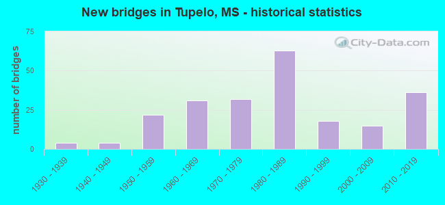
- New bridges - historical statistics
- 41930-1939
- 41940-1949
- 221950-1959
- 311960-1969
- 321970-1979
- 631980-1989
- 181990-1999
- 152000-2009
- 362010-2019
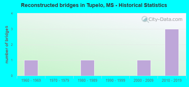
- Reconstructed bridges - Historical Statistics
- 11960-1969
- 01970-1979
- 11980-1989
- 01990-1999
- 12000-2009
- 32010-2019
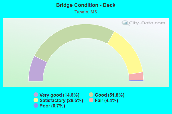
- Bridge Condition - Deck
- 14.6%Very good
- 51.8%Good
- 28.5%Satisfactory
- 4.4%Fair
- 0.7%Poor
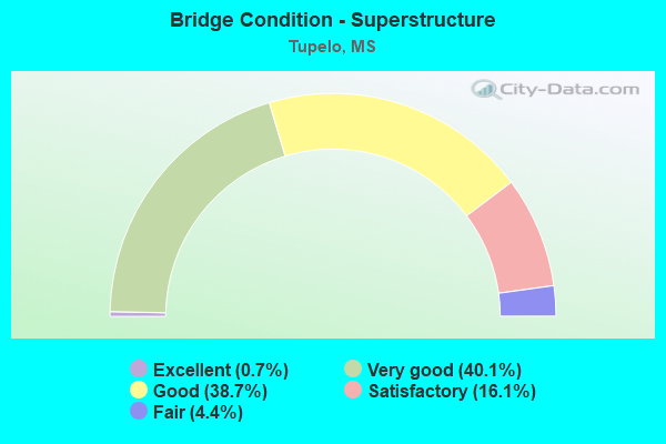
- Bridge Condition - Superstructure
- 0.7%Excellent
- 40.1%Very good
- 38.7%Good
- 16.1%Satisfactory
- 4.4%Fair
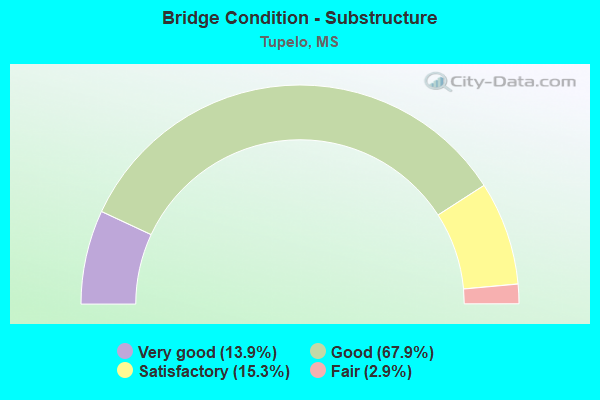
- Bridge Condition - Substructure
- 13.9%Very good
- 67.9%Good
- 15.3%Satisfactory
- 2.9%Fair
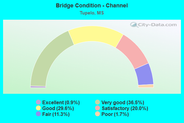
- Bridge Condition - Channel
- 0.9%Excellent
- 36.5%Very good
- 29.6%Good
- 20.0%Satisfactory
- 11.3%Fair
- 1.7%Poor
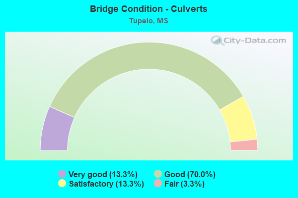
- Bridge Condition - Culverts
- 13.3%Very good
- 70.0%Good
- 13.3%Satisfactory
- 3.3%Fair
Find on map >> Show street view
Structure Number: 5570050P, Location: 1.54 MILES TO MS ROUTE 6. (Lat: 34.231444, Lng: -88.770083), Route carried "on" structure: Federal lands road 1, Year Built: 1958, Status: Open, Structure Length: 3.19m (10.47ft), Average Daily Traffic: 3,959 (year 2012), Truck Traffic: 1%, Average Future Daily Traffic: 4,355 (year 2032), Design Load: H 15, Features Intersected: LITTLE COONEWAH CREEK, Facility Carried by Structure: NATCHEZ TRACE PARK
Minimum Vertical Clearance: 30+ m (98+ ft), Kilometerpoint: 415.774, Lanes on structure: 2, Owner: National Park Service, Approaching Roadway Width: 9.8m (32.2ft), Skew: 3 degrees, Material/Design: Concrete continuous, Design/Construction: Slab, Number Of Spans In Main Unit: 3, Length of Maximum Span: 12.2m (40.0ft), Curb-To-Curb Width: 8.5m (27.9ft), Out-to-Out Width: 9.9m (32.5ft)
Condition: Deck: Satisfactory, Superstructure: Satisfactory, Substructure: Satisfactory, Channel: Fair, Operating Rating: 53.5 metric tons, Method Used To Determine Operating Rating: Load Factor (LF), Inventory Rating: 31.7 metric tons, Method Used To Determine Inventory Rating: Load Factor (LF), Structural Evaluation: Equal to present minimum criteria, Deck Geometry: Meets minimum limits, Waterway Adequacy: Equal to present desirable criteria, Approach Roadway Alignment: Equal to present desirable criteria, Designated Inspection Frequency: Every 24 months, Inspection Date: March 2021, Bridge Improvement Cost: $200,000, Roadway Improvement Cost: $20,000, Total Project Cost: $300,000 ( Estimate for 2018), Deck Structure Type: Concrete Cast-file-Place, Wearing Surface/Protective System: Wearing Surface: Bituminous
Find on map >> Show street view
Structure Number: 5570051P, Location: 2.0 MILES SOUTH OF MS ROU (Lat: 34.225833, Lng: -88.774722), Route carried "on" structure: Federal lands road 1, Year Built: 1958, Status: Open, Structure Length: 4.50m (14.76ft), Average Daily Traffic: 3,959 (year 2012), Truck Traffic: 1%, Average Future Daily Traffic: 4,355 (year 2032), Design Load: H 15, Features Intersected: BIG COONEWAH CREEK, Facility Carried by Structure: NATCHEZ TRACE PARK
Minimum Vertical Clearance: 30+ m (98+ ft), Kilometerpoint: 415.034, Lanes on structure: 2, Owner: National Park Service, Approaching Roadway Width: 9.8m (32.2ft), Skew: 4 degrees, Material/Design: Concrete continuous, Design/Construction: Slab, Number Of Spans In Main Unit: 5, Length of Maximum Span: 11.1m (36.4ft), Curb-To-Curb Width: 8.6m (28.2ft), Out-to-Out Width: 9.9m (32.5ft)
Condition: Deck: Good, Superstructure: Good, Substructure: Satisfactory, Channel: Fair, Operating Rating: 32.7 metric tons, Method Used To Determine Operating Rating: Field evaluation and documented engineering judgment, Inventory Rating: 19.0 metric tons, Method Used To Determine Inventory Rating: Field evaluation and documented engineering judgment, Structural Evaluation: Somewhat better than minimum adequacy, Deck Geometry: Meets minimum limits, Waterway Adequacy: Equal to present desirable criteria, Approach Roadway Alignment: Equal to present desirable criteria, Designated Inspection Frequency: Every 24 months, Inspection Date: March 2021, Bridge Improvement Cost: $100,000, Roadway Improvement Cost: $10,000, Total Project Cost: $150,000 ( Estimate for 2018), Deck Structure Type: Concrete Cast-file-Place, Wearing Surface/Protective System: Wearing Surface: Bituminous
Find on map >> Show street view
Structure Number: 5570290P, Location: 2.65 MILES SOUTH OF U.S. (Lat: 34.299194, Lng: -88.725056), Route carried "on" structure: Federal lands road 1, Year Built: 1980, Status: Open, Structure Length: 11.13m (36.52ft), Average Daily Traffic: 2,920 (year 2012), Truck Traffic: 1%, Average Future Daily Traffic: 3,212 (year 2032), Design Load: HS 20, Features Intersected: U.S. ROUTE 78, Facility Carried by Structure: NATCHEZ TRACE PARK
Minimum Vertical Clearance: 30+ m (98+ ft), Kilometerpoint: 424.432, Lanes on structure: 2, Lanes under structure: 4, Owner: National Park Service, Approaching Roadway Width: 9.8m (32.2ft), Material/Design: Prestressed concrete continuous, Design/Construction: Stringer/Multi-beam, Number Of Spans In Main Unit: 4, Length of Maximum Span: 33.5m (109.9ft), Curb-To-Curb Width: 12.8m (42.0ft), Out-to-Out Width: 13.7m (44.9ft)
Condition: Deck: Satisfactory, Superstructure: Fair, Substructure: Satisfactory, Operating Rating: 54.4 metric tons, Method Used To Determine Operating Rating: Field evaluation and documented engineering judgment, Inventory Rating: 32.7 metric tons, Method Used To Determine Inventory Rating: Field evaluation and documented engineering judgment, Structural Evaluation: Somewhat better than minimum adequacy, Deck Geometry: Equal to present minimum criteria, Underclear: Better than present minimum criteria, Approach Roadway Alignment: Equal to present desirable criteria, Designated Inspection Frequency: Every 24 months, Inspection Date: March 2021, Bridge Improvement Cost: $250,000, Roadway Improvement Cost: $25,000, Total Project Cost: $375,000 ( Estimate for 2016), Deck Structure Type: Concrete Cast-file-Place
Find on map >> Show street view
Structure Number: 5570333P, Location: 6.0 MILES SOUTH OF MS ROU (Lat: 34.174333, Lng: -88.804639), Route carried "on" structure: Federal lands road 1, Year Built: 1960, Status: Open, Structure Length: 1.04m (3.41ft), Average Daily Traffic: 3,959 (year 2012), Truck Traffic: 1%, Average Future Daily Traffic: 4,355 (year 2032), Design Load: H 15, Features Intersected: REEDS BRANCH, Facility Carried by Structure: NATCHEZ TRACE PARK
Minimum Vertical Clearance: 30+ m (98+ ft), Kilometerpoint: 408.532, Lanes on structure: 2, Owner: National Park Service, Approaching Roadway Width: 9.8m (32.2ft), Skew: 2 degrees, Material/Design: Concrete, Design/Construction: Culvert, Number Of Spans In Main Unit: 3, Length of Maximum Span: 3.6m (11.8ft)
Condition: Channel: Poor, Culverts: Satisfactory, Operating Rating: 40.8 metric tons, Method Used To Determine Operating Rating: Field evaluation and documented engineering judgment, Inventory Rating: 24.5 metric tons, Method Used To Determine Inventory Rating: Field evaluation and documented engineering judgment, Structural Evaluation: Equal to present minimum criteria, Waterway Adequacy: Equal to present desirable criteria, Approach Roadway Alignment: Equal to present desirable criteria, Designated Inspection Frequency: Every 24 months, Inspection Date: March 2021, Bridge Improvement Cost: $200,000, Roadway Improvement Cost: $20,000, Total Project Cost: $300,000 ( Estimate for 2018)
Find on map >> Show street view
Structure Number: 5570334P, Location: 5.0 MILES SOUTH OF MS ROU (Lat: 34.187750, Lng: -88.794083), Route carried "on" structure: Federal lands road 1, Year Built: 1958, Status: Open, Structure Length: 1.31m (4.30ft), Average Daily Traffic: 3,959 (year 2012), Truck Traffic: 1%, Average Future Daily Traffic: 4,355 (year 2032), Design Load: H 20, Features Intersected: GORMANS BRANCH, Facility Carried by Structure: NATCHEZ TRACE PARK
Minimum Vertical Clearance: 30+ m (98+ ft), Kilometerpoint: 410.222, Lanes on structure: 2, Owner: National Park Service, Approaching Roadway Width: 9.8m (32.2ft), Skew: 6 degrees, Material/Design: Concrete, Design/Construction: Culvert, Number Of Spans In Main Unit: 2, Length of Maximum Span: 6.6m (21.7ft)
Condition: Channel: Fair, Culverts: Satisfactory, Inventory Rating: 54.4 metric tons, Method Used To Determine Inventory Rating: Load Factor (LF), Structural Evaluation: Equal to present minimum criteria, Waterway Adequacy: Equal to present desirable criteria, Approach Roadway Alignment: Equal to present desirable criteria, Designated Inspection Frequency: Every 24 months, Inspection Date: March 2021, Bridge Improvement Cost: $92,000, Roadway Improvement Cost: $9,000, Total Project Cost: $138,000 ( Estimate for 2018)
Find on map >> Show street view
Structure Number: 5570335P, Location: 4.7 MILES SOUTH OF MS ROU (Lat: 34.190722, Lng: -88.792028), Route carried "on" structure: Federal lands road 1, Year Built: 1958, Status: Open, Structure Length: 0.66m (2.17ft), Average Daily Traffic: 3,959 (year 2012), Truck Traffic: 1%, Average Future Daily Traffic: 4,355 (year 2032), Design Load: H 20, Features Intersected: STREAM, Facility Carried by Structure: NATCHEZ TRACE PARK
Minimum Vertical Clearance: 30+ m (98+ ft), Kilometerpoint: 410.705, Lanes on structure: 2, Owner: National Park Service, Approaching Roadway Width: 9.8m (32.2ft), Skew: 6 degrees, Material/Design: Concrete, Design/Construction: Culvert, Number Of Spans In Main Unit: 2, Length of Maximum Span: 3.3m (10.8ft)
Condition: Channel: Good, Culverts: Satisfactory, Operating Rating: 69.8 metric tons, Method Used To Determine Operating Rating: Load Factor (LF), Inventory Rating: 41.7 metric tons, Method Used To Determine Inventory Rating: Load Factor (LF), Structural Evaluation: Equal to present minimum criteria, Waterway Adequacy: Equal to present desirable criteria, Approach Roadway Alignment: Equal to present desirable criteria, Designated Inspection Frequency: Every 24 months, Inspection Date: March 2021, Bridge Improvement Cost: $17,000, Roadway Improvement Cost: $2,000, Total Project Cost: $26,000 ( Estimate for 2018)
Find on map >> Show street view
Structure Number: 5570336P, Location: 1.8 MILES SOUTH OF MS ROU (Lat: 34.228778, Lng: -88.772583), Route carried "on" structure: Federal lands road 1, Year Built: 1958, Status: Open, Structure Length: 0.90m (2.95ft), Average Daily Traffic: 3,959 (year 2012), Truck Traffic: 1%, Average Future Daily Traffic: 4,355 (year 2032), Design Load: H 20, Features Intersected: LITTLE COONEWAH CREEK, Facility Carried by Structure: NATCHEZ TRACE PARK
Minimum Vertical Clearance: 30+ m (98+ ft), Kilometerpoint: 415.372, Lanes on structure: 2, Owner: National Park Service, Approaching Roadway Width: 9.8m (32.2ft), Skew: 4 degrees, Material/Design: Concrete, Design/Construction: Culvert, Number Of Spans In Main Unit: 2, Length of Maximum Span: 4.5m (14.8ft)
Condition: Channel: Satisfactory, Culverts: Good, Operating Rating: 78.0 metric tons, Method Used To Determine Operating Rating: Load Factor (LF), Inventory Rating: 46.3 metric tons, Method Used To Determine Inventory Rating: Load Factor (LF), Structural Evaluation: Better than present minimum criteria, Waterway Adequacy: Equal to present desirable criteria, Approach Roadway Alignment: Equal to present desirable criteria, Designated Inspection Frequency: Every 48 months, Inspection Date: March 2021, Bridge Improvement Cost: $85,000, Roadway Improvement Cost: $9,000, Total Project Cost: $128,000 ( Estimate for 2018)
Find on map >> Show street view
Structure Number: 5570338P, Location: 1.63 MILES SOUTH OF U.S. (Lat: 34.278056, Lng: -88.736194), Route carried "on" structure: Federal lands road 1, Year Built: 1959, Status: Open, Structure Length: 0.66m (2.17ft), Average Daily Traffic: 2,920 (year 2012), Truck Traffic: 1%, Average Future Daily Traffic: 3,212 (year 2032), Design Load: H 20, Features Intersected: STREAM, Facility Carried by Structure: NATCHEZ TRACE PARK
Minimum Vertical Clearance: 30+ m (98+ ft), Kilometerpoint: 421.809, Lanes on structure: 2, Owner: National Park Service, Approaching Roadway Width: 9.8m (32.2ft), Skew: 1 degrees, Material/Design: Concrete, Design/Construction: Culvert, Number Of Spans In Main Unit: 2, Length of Maximum Span: 3.3m (10.8ft)
Condition: Channel: Fair, Culverts: Fair, Inventory Rating: 78.0 metric tons, Method Used To Determine Inventory Rating: Load Factor (LF), Structural Evaluation: Somewhat better than minimum adequacy, Waterway Adequacy: Equal to present desirable criteria, Approach Roadway Alignment: Equal to present desirable criteria, Designated Inspection Frequency: Every 24 months, Inspection Date: March 2021, Bridge Improvement Cost: $76,000, Roadway Improvement Cost: $8,000, Total Project Cost: $114,000 ( Estimate for 2018)
Find on map >> Show street view
Structure Number: 5570481P, Location: 4.6 MI. SOUTH OF MS ROUTE (Lat: 34.191472, Lng: -88.791611), Route carried "on" structure: Federal lands road 11, Year Built: 2001, Status: Open, Structure Length: 5.04m (16.54ft), Average Daily Traffic: 3,960 (year 2012), Truck Traffic: 1%, Average Future Daily Traffic: 4,752 (year 2032), Features Intersected: PALMETTO ROAD, Facility Carried by Structure: NATCHEZ TRACE PARK
Minimum Vertical Clearance: 30+ m (98+ ft), Kilometerpoint: 410.866, Lanes on structure: 2, Lanes under structure: 2, Owner: National Park Service, Approaching Roadway Width: 9.8m (32.2ft), Skew: 2 degrees, Material/Design: Concrete continuous, Design/Construction: Slab, Number Of Spans In Main Unit: 3, Length of Maximum Span: 21.4m (70.2ft), Curb-To-Curb Width: 10.4m (34.1ft), Out-to-Out Width: 11.3m (37.1ft)
Condition: Deck: Satisfactory, Superstructure: Satisfactory, Substructure: Satisfactory, Structural Evaluation: Equal to present minimum criteria, Deck Geometry: Somewhat better than minimum adequacy, Underclear: Meets minimum limits, Approach Roadway Alignment: Equal to present desirable criteria, Designated Inspection Frequency: Every 24 months, Inspection Date: March 2021, Bridge Improvement Cost: $45,000, Roadway Improvement Cost: $5,000, Total Project Cost: $68,000 ( Estimate for 2018), Deck Structure Type: Concrete Cast-file-Place, Wearing Surface/Protective System: Wearing Surface: Bituminous
Find on map >> Show street view
Structure Number: 5570507P, Location: Natchez Trace Parkway ove (Lat: 34.212472, Lng: -88.781722), Route carried "on" structure: Federal lands road 11, Year Built: 2010, Status: Open, Structure Length: 17.37m (56.99ft), Average Daily Traffic: 3,960 (year 2012), Truck Traffic: 1%, Average Future Daily Traffic: 4,752 (year 2032), Design Load: HS 20, Features Intersected: MS 6 AND 278, Facility Carried by Structure: NATCHEZ TRACE PARK
Minimum Vertical Clearance: 30+ m (98+ ft), Kilometerpoint: 413.430, Lanes on structure: 2, Lanes under structure: 4, Owner: National Park Service, Approaching Roadway Width: 10.3m (33.8ft), Skew: 2 degrees, Material/Design: Prestressed concrete continuous, Design/Construction: Box Beam or Girders - Single/Spread, Number Of Spans In Main Unit: 3, Length of Maximum Span: 70.1m (230.0ft), Curb-To-Curb Width: 10.4m (34.1ft), Out-to-Out Width: 11.3m (37.1ft)
Condition: Deck: Good, Superstructure: Very good, Substructure: Good, Inventory Rating: 47.2 metric tons, Method Used To Determine Inventory Rating: Load Factor (LF), Structural Evaluation: Better than present minimum criteria, Deck Geometry: Somewhat better than minimum adequacy, Underclear: High priority of corrective action, Approach Roadway Alignment: Equal to present desirable criteria, Designated Inspection Frequency: Every 24 months, Inspection Date: March 2021, Bridge Improvement Cost: $11,000, Roadway Improvement Cost: $1,000, Total Project Cost: $17,000 ( Estimate for 2021), Deck Structure Type: Concrete Cast-file-Place, Wearing Surface/Protective System: Wearing Surface: Bituminous, Deck Protection: Epoxy Coated Reinforcing
Find on map >> Show street view
Structure Number: 5570508P, Location: NATCHEZ TRACE PARKWAY OVE (Lat: 34.206258, Lng: -88.784147), Route carried "on" structure: Federal lands road 11, Year Built: 2010, Status: Open, Structure Length: 6.43m (21.10ft), Average Daily Traffic: 3,960 (year 2012), Truck Traffic: 1%, Average Future Daily Traffic: 4,752 (year 2032), Design Load: HS 20, Features Intersected: MS ROUTE 900, Facility Carried by Structure: NATCHEZ TRACE PARK
Minimum Vertical Clearance: 30+ m (98+ ft), Kilometerpoint: 412.620, Lanes on structure: 2, Lanes under structure: 2, Owner: National Park Service, Approaching Roadway Width: 10.3m (33.8ft), Material/Design: Prestressed concrete continuous, Design/Construction: Box Beam or Girders - Single/Spread, Number Of Spans In Main Unit: 3, Length of Maximum Span: 44.2m (145.0ft), Curb-To-Curb Width: 10.4m (34.1ft), Out-to-Out Width: 11.3m (37.1ft)
Condition: Deck: Very good, Superstructure: Very good, Substructure: Good, Inventory Rating: 65.3 metric tons, Method Used To Determine Inventory Rating: Load Factor (LF), Structural Evaluation: Better than present minimum criteria, Deck Geometry: Somewhat better than minimum adequacy, Underclear: High priority of corrective action, Approach Roadway Alignment: Equal to present desirable criteria, Designated Inspection Frequency: Every 24 months, Inspection Date: March 2021, Deck Structure Type: Concrete Cast-file-Place, Wearing Surface/Protective System: Wearing Surface: Bituminous, Deck Protection: Epoxy Coated Reinforcing
Find on map >> Show street view
Structure Number: SA4100000000001, Location: SEC 9 T 7S R 5E (Lat: 34.495278, Lng: -88.787500), Route carried "on" structure: County highway 101, Year Built: 1989, Status: Open, Structure Length: 2.83m (9.28ft), Average Daily Traffic: 500 (year 2015), Truck Traffic: 8%, Average Future Daily Traffic: 750 (year 2035), Design Load: HS 20, Features Intersected: CAMP CREEK, Facility Carried by Structure: CR 2900
Minimum Vertical Clearance: 30+ m (98+ ft), Kilometerpoint: 0.643, Lanes on structure: 2, Owner: County Highway Agency, Approaching Roadway Width: 7.9m (25.9ft), Material/Design: Concrete, Design/Construction: Channel Beam, Number Of Spans In Main Unit: 3, Length of Maximum Span: 9.4m (30.8ft), Curb or Sidewalk Widths: Left: 0.5m (1.6ft), Right: 0.5m (1.6ft), Curb-To-Curb Width: 8.5m (27.9ft), Out-to-Out Width: 9.5m (31.2ft)
Condition: Deck: Very good, Superstructure: Very good, Substructure: Very good, Channel: Very good, Operating Rating: 63.1 metric tons, Method Used To Determine Operating Rating: Load Factor (LF), Inventory Rating: 37.9 metric tons, Method Used To Determine Inventory Rating: Load Factor (LF), Structural Evaluation: Equal to present desirable criteria, Deck Geometry: Somewhat better than minimum adequacy, Waterway Adequacy: Equal to present desirable criteria, Approach Roadway Alignment: Equal to present desirable criteria, Length Of Structure Improvement: 3.78m (12.40ft), Designated Inspection Frequency: Every 24 months, Inspection Date: January 2021, Bridge Improvement Cost: $226,000, Roadway Improvement Cost: $23,000, Total Project Cost: $279,000 ( Estimate for 2016), Deck Structure Type: Concrete Precast Panels, Wearing Surface/Protective System: Wearing Surface: Monolithic Concrete
Find on map >> Show street view
Structure Number: SA4100000000039, Location: SEC 32 T 8S R 5E (Lat: 34.345356, Lng: -88.789742), Route carried "on" structure: County highway 53, Year Built: 1998, Status: Open, Structure Length: 2.10m (6.89ft), Average Daily Traffic: 150 (year 2015), Truck Traffic: 8%, Average Future Daily Traffic: 225 (year 2035), Design Load: HS 20, Features Intersected: BUSFALOBA CREEK, Facility Carried by Structure: CR 203
Minimum Vertical Clearance: 30+ m (98+ ft), Kilometerpoint: 0.643, Lanes on structure: 2, Owner: County Highway Agency, Approaching Roadway Width: 8.5m (27.9ft), Material/Design: Concrete, Design/Construction: Channel Beam, Number Of Spans In Main Unit: 3, Length of Maximum Span: 9.4m (30.8ft), Curb or Sidewalk Widths: Left: 0.5m (1.6ft), Right: 0.5m (1.6ft), Curb-To-Curb Width: 8.5m (27.9ft), Out-to-Out Width: 9.5m (31.2ft)
Condition: Deck: Very good, Superstructure: Very good, Substructure: Good, Channel: Very good, Operating Rating: 63.1 metric tons, Method Used To Determine Operating Rating: Load Factor (LF), Inventory Rating: 37.9 metric tons, Method Used To Determine Inventory Rating: Load Factor (LF), Structural Evaluation: Better than present minimum criteria, Deck Geometry: Equal to present minimum criteria, Waterway Adequacy: Equal to present desirable criteria, Approach Roadway Alignment: Equal to present desirable criteria, Designated Inspection Frequency: Every 24 months, Inspection Date: January 2021, Deck Structure Type: Concrete Precast Panels, Wearing Surface/Protective System: Wearing Surface: Bituminous
Find on map >> Show street view
Structure Number: SA410000000004, Location: SEC 33 T 8S R 5E (Lat: 34.341833, Lng: -88.780111), Route carried "on" structure: County highway 55, Year Built: 2002, Status: Open, Structure Length: 2.82m (9.25ft), Average Daily Traffic: 100 (year 2015), Truck Traffic: 10%, Average Future Daily Traffic: 150 (year 2035), Design Load: HS 20, Features Intersected: BUSFALOBA CREEK, Facility Carried by Structure: CR 1836
Minimum Vertical Clearance: 30+ m (98+ ft), Kilometerpoint: 2.092, Lanes on structure: 2, Owner: County Highway Agency, Approaching Roadway Width: 8.5m (27.9ft), Skew: 3 degrees, Material/Design: Concrete, Design/Construction: Channel Beam, Number Of Spans In Main Unit: 3, Length of Maximum Span: 9.4m (30.8ft), Curb or Sidewalk Widths: Left: 0.5m (1.6ft), Right: 0.5m (1.6ft), Curb-To-Curb Width: 8.5m (27.9ft), Out-to-Out Width: 9.5m (31.2ft)
Condition: Deck: Very good, Superstructure: Very good, Substructure: Good, Channel: Good, Operating Rating: 63.1 metric tons, Method Used To Determine Operating Rating: Load Factor (LF), Inventory Rating: 37.9 metric tons, Method Used To Determine Inventory Rating: Load Factor (LF), Structural Evaluation: Better than present minimum criteria, Deck Geometry: Better than present minimum criteria, Waterway Adequacy: Equal to present desirable criteria, Approach Roadway Alignment: Equal to present desirable criteria, Designated Inspection Frequency: Every 24 months, Inspection Date: January 2021, Deck Structure Type: Concrete Precast Panels, Wearing Surface/Protective System: Wearing Surface: Monolithic Concrete
Find on map >> Show street view
Structure Number: SA4100000000041, Location: SEC 35 T 8S R 5E (Lat: 34.339722, Lng: -88.746111), Route carried "on" structure: County highway 58, Year Built: 2010, Status: Open, Structure Length: 5.49m (18.01ft), Average Daily Traffic: 150 (year 2015), Truck Traffic: 8%, Average Future Daily Traffic: 225 (year 2035), Design Load: HS 20, Features Intersected: YONABA CREEK, Facility Carried by Structure: CR 461
Minimum Vertical Clearance: 30+ m (98+ ft), Kilometerpoint: 2.253, Lanes on structure: 2, Owner: County Highway Agency, Approaching Roadway Width: 7.3m (24.0ft), Material/Design: Prestressed concrete, Design/Construction: Stringer/Multi-beam, Number Of Spans In Main Unit: 3, Length of Maximum Span: 30.5m (100.1ft), Curb or Sidewalk Widths: Left: 0.5m (1.6ft), Right: 0.5m (1.6ft), Curb-To-Curb Width: 8.5m (27.9ft), Out-to-Out Width: 9.5m (31.2ft)
Condition: Deck: Very good, Superstructure: Excellent, Substructure: Very good, Channel: Good, Operating Rating: 64.7 metric tons, Method Used To Determine Operating Rating: Load Factor (LF), Inventory Rating: 27.8 metric tons, Method Used To Determine Inventory Rating: Load Factor (LF), Structural Evaluation: Equal to present minimum criteria, Deck Geometry: Equal to present minimum criteria, Waterway Adequacy: Equal to present desirable criteria, Approach Roadway Alignment: Equal to present desirable criteria, Designated Inspection Frequency: Every 24 months, Inspection Date: January 2021, Deck Structure Type: Concrete Cast-file-Place, Wearing Surface/Protective System: Wearing Surface: Monolithic Concrete
Find on map >> Show street view
Structure Number: SA4100000000058, Location: SEC 3 T 9S R 5E (Lat: 34.322906, Lng: -88.767517), Route carried "on" structure: County highway 50, Year Built: 2002, Status: Open, Structure Length: 2.10m (6.89ft), Average Daily Traffic: 125 (year 2015), Truck Traffic: 8%, Average Future Daily Traffic: 188 (year 2035), Design Load: HS 20, Features Intersected: UNION BRANCH, Facility Carried by Structure: CR 1740
Minimum Vertical Clearance: 30+ m (98+ ft), Kilometerpoint: 2.253, Lanes on structure: 2, Owner: County Highway Agency, Approaching Roadway Width: 8.5m (27.9ft), Material/Design: Concrete, Design/Construction: Channel Beam, Number Of Spans In Main Unit: 3, Length of Maximum Span: 9.4m (30.8ft), Curb or Sidewalk Widths: Left: 0.5m (1.6ft), Right: 0.5m (1.6ft), Curb-To-Curb Width: 8.5m (27.9ft), Out-to-Out Width: 9.5m (31.2ft)
Condition: Deck: Very good, Superstructure: Very good, Substructure: Very good, Channel: Very good, Operating Rating: 63.1 metric tons, Method Used To Determine Operating Rating: Load Factor (LF), Inventory Rating: 37.9 metric tons, Method Used To Determine Inventory Rating: Load Factor (LF), Structural Evaluation: Equal to present desirable criteria, Deck Geometry: Equal to present minimum criteria, Waterway Adequacy: Equal to present desirable criteria, Approach Roadway Alignment: Equal to present minimum criteria, Designated Inspection Frequency: Every 24 months, Inspection Date: Febuary 2021, Deck Structure Type: Concrete Precast Panels, Wearing Surface/Protective System: Wearing Surface: Bituminous
Find on map >> Show street view
Structure Number: SA4100000000059, Location: SEC 3 T 9S R 5E (Lat: 34.322825, Lng: -88.764044), Route carried "on" structure: County highway 50, Year Built: 2002, Status: Open, Structure Length: 2.10m (6.89ft), Average Daily Traffic: 125 (year 2015), Truck Traffic: 8%, Average Future Daily Traffic: 188 (year 2035), Design Load: HS 20, Features Intersected: BUSFALOBA CREEK, Facility Carried by Structure: CR 1740
Minimum Vertical Clearance: 30+ m (98+ ft), Kilometerpoint: 2.735, Lanes on structure: 2, Owner: County Highway Agency, Approaching Roadway Width: 8.5m (27.9ft), Skew: 3 degrees, Material/Design: Concrete, Design/Construction: Channel Beam, Number Of Spans In Main Unit: 3, Length of Maximum Span: 9.4m (30.8ft), Curb or Sidewalk Widths: Left: 0.5m (1.6ft), Right: 0.5m (1.6ft), Curb-To-Curb Width: 8.5m (27.9ft), Out-to-Out Width: 9.5m (31.2ft)
Condition: Deck: Very good, Superstructure: Very good, Substructure: Good, Channel: Very good, Operating Rating: 63.1 metric tons, Method Used To Determine Operating Rating: Load Factor (LF), Inventory Rating: 37.9 metric tons, Method Used To Determine Inventory Rating: Load Factor (LF), Structural Evaluation: Better than present minimum criteria, Deck Geometry: Equal to present minimum criteria, Waterway Adequacy: Equal to present desirable criteria, Approach Roadway Alignment: Equal to present desirable criteria, Designated Inspection Frequency: Every 24 months, Inspection Date: January 2021, Deck Structure Type: Concrete Precast Panels, Wearing Surface/Protective System: Wearing Surface: Bituminous
Find on map >> Show street view
Structure Number: SA410000000006, Location: SEC 7 T 9S R 5E B (Lat: 34.307500, Lng: -88.820833), Route carried "on" structure: County highway 1866, Year Built: 1999, Status: Open, Structure Length: 2.10m (6.89ft), Average Daily Traffic: 2,700 (year 2015), Truck Traffic: 8%, Average Future Daily Traffic: 4,050 (year 2035), Design Load: HS 20, Features Intersected: UNNAMED CREEK, Facility Carried by Structure: CR 1600
Minimum Vertical Clearance: 30+ m (98+ ft), Kilometerpoint: 0.482, Lanes on structure: 2, Owner: County Highway Agency, Approaching Roadway Width: 9.1m (29.9ft), Material/Design: Concrete, Design/Construction: Channel Beam, Number Of Spans In Main Unit: 3, Length of Maximum Span: 9.4m (30.8ft), Curb or Sidewalk Widths: Left: 0.5m (1.6ft), Right: 0.5m (1.6ft), Curb-To-Curb Width: 9.8m (32.2ft), Out-to-Out Width: 10.8m (35.4ft)
Condition: Deck: Very good, Superstructure: Very good, Substructure: Very good, Channel: Very good, Operating Rating: 59.8 metric tons, Method Used To Determine Operating Rating: Load Factor (LF), Inventory Rating: 36.0 metric tons, Method Used To Determine Inventory Rating: Load Factor (LF), Structural Evaluation: Equal to present desirable criteria, Deck Geometry: Meets minimum limits, Waterway Adequacy: Equal to present desirable criteria, Approach Roadway Alignment: Equal to present desirable criteria, Designated Inspection Frequency: Every 24 months, Inspection Date: January 2021, Deck Structure Type: Concrete Precast Panels, Wearing Surface/Protective System: Wearing Surface: Monolithic Concrete
Find on map >> Show street view
Structure Number: SA4100000000061, Location: SEC 7 T 9S R 5E B (Lat: 34.307778, Lng: -88.815556), Route carried "on" structure: County highway 1866, Year Built: 1999, Status: Open, Structure Length: 2.10m (6.89ft), Average Daily Traffic: 2,700 (year 2015), Truck Traffic: 8%, Average Future Daily Traffic: 4,050 (year 2035), Design Load: HS 20, Features Intersected: LITTLE COONEWAH CREEK, Facility Carried by Structure: CR 1600
Minimum Vertical Clearance: 30+ m (98+ ft), Kilometerpoint: 0.965, Lanes on structure: 2, Owner: County Highway Agency, Approaching Roadway Width: 9.1m (29.9ft), Material/Design: Concrete, Design/Construction: Channel Beam, Number Of Spans In Main Unit: 3, Length of Maximum Span: 9.4m (30.8ft), Curb or Sidewalk Widths: Left: 0.5m (1.6ft), Right: 0.5m (1.6ft), Curb-To-Curb Width: 9.8m (32.2ft), Out-to-Out Width: 10.8m (35.4ft)
Condition: Deck: Very good, Superstructure: Very good, Substructure: Very good, Channel: Very good, Operating Rating: 59.8 metric tons, Method Used To Determine Operating Rating: Load Factor (LF), Inventory Rating: 36.0 metric tons, Method Used To Determine Inventory Rating: Load Factor (LF), Structural Evaluation: Equal to present desirable criteria, Deck Geometry: Meets minimum limits, Waterway Adequacy: Equal to present desirable criteria, Approach Roadway Alignment: Equal to present desirable criteria, Designated Inspection Frequency: Every 24 months, Inspection Date: January 2021, Deck Structure Type: Concrete Precast Panels, Wearing Surface/Protective System: Wearing Surface: Monolithic Concrete
Find on map >> Show street view
Structure Number: SA4100000000063, Location: SEC 11 T 9S R 5E B (Lat: 34.309167, Lng: -88.737222), Route carried "on" structure: County highway 675, Year Built: 1967, Status: Open, Structure Length: 1.83m (6.00ft), Average Daily Traffic: 2,000 (year 2015), Truck Traffic: 8%, Average Future Daily Traffic: 3,000 (year 2035), Design Load: H 15, Features Intersected: BUSFALOBA CREEK, Facility Carried by Structure: MT. VERNON ROAD
Minimum Vertical Clearance: 30+ m (98+ ft), Kilometerpoint: 2.735, Lanes on structure: 2, Owner: City or Municipal Highway Agency, Approaching Roadway Width: 7.0m (23.0ft), Material/Design: Concrete, Design/Construction: Slab, Number Of Spans In Main Unit: 3, Length of Maximum Span: 6.1m (20.0ft), Curb or Sidewalk Widths: Left: 0.7m (2.3ft), Right: 0.7m (2.3ft), Curb-To-Curb Width: 7.3m (24.0ft), Out-to-Out Width: 8.7m (28.5ft)
Condition: Deck: Good, Superstructure: Good, Substructure: Good, Channel: Good, Operating Rating: 43.2 metric tons, Method Used To Determine Operating Rating: Load Factor (LF), Inventory Rating: 25.8 metric tons, Method Used To Determine Inventory Rating: Load Factor (LF), Structural Evaluation: Equal to present minimum criteria, Deck Geometry: Meets minimum limits, Waterway Adequacy: Equal to present desirable criteria, Approach Roadway Alignment: Equal to present desirable criteria, Length Of Structure Improvement: 2.83m (9.28ft), Designated Inspection Frequency: Every 24 months, Inspection Date: January 2021, Bridge Improvement Cost: $169,000, Roadway Improvement Cost: $17,000, Total Project Cost: $208,000 ( Estimate for 2016), Deck Structure Type: Concrete Cast-file-Place, Wearing Surface/Protective System: Wearing Surface: Bituminous
Find on map >> Show street view
Structure Number: SA4100000000064, Location: SEC 14 T 9S R 5E B (Lat: 34.308381, Lng: -88.737861), Route carried "on" structure: County highway 675, Year Built: 1963, Status: Open, Structure Length: 3.66m (12.01ft), Average Daily Traffic: 2,000 (year 2015), Truck Traffic: 8%, Average Future Daily Traffic: 3,000 (year 2035), Design Load: H 15, Features Intersected: TOWN CREEK, Facility Carried by Structure: MT. VERNON ROAD
Minimum Vertical Clearance: 30+ m (98+ ft), Kilometerpoint: 2.574, Lanes on structure: 2, Owner: City or Municipal Highway Agency, Approaching Roadway Width: 7.0m (23.0ft), Material/Design: Prestressed concrete, Design/Construction: Stringer/Multi-beam, Number Of Spans In Main Unit: 3, Length of Maximum Span: 12.2m (40.0ft), Curb or Sidewalk Widths: Left: 0.5m (1.6ft), Right: 0.5m (1.6ft), Curb-To-Curb Width: 7.3m (24.0ft), Out-to-Out Width: 8.3m (27.2ft)
Condition: Deck: Good, Superstructure: Very good, Substructure: Good, Channel: Very good, Operating Rating: 58.5 metric tons, Method Used To Determine Operating Rating: Load Factor (LF), Inventory Rating: 21.3 metric tons, Method Used To Determine Inventory Rating: Load Factor (LF), Structural Evaluation: Somewhat better than minimum adequacy, Deck Geometry: Meets minimum limits, Waterway Adequacy: Equal to present desirable criteria, Approach Roadway Alignment: Equal to present desirable criteria, Length Of Structure Improvement: 4.27m (14.01ft), Designated Inspection Frequency: Every 24 months, Inspection Date: January 2021, Bridge Improvement Cost: $255,000, Roadway Improvement Cost: $25,000, Total Project Cost: $314,000 ( Estimate for 2016), Deck Structure Type: Concrete Cast-file-Place, Wearing Surface/Protective System: Wearing Surface: Bituminous
Find on map >> Show street view
Structure Number: SA4100000000065, Location: SEC 16 T 9S R 5E (Lat: 34.296611, Lng: -88.773861), Route carried "on" structure: County highway 2400, Year Built: 1981, Status: Open, Structure Length: 6.16m (20.21ft), Average Daily Traffic: 2,200 (year 2020), Truck Traffic: 8%, Average Future Daily Traffic: 3,300 (year 2043), Design Load: HS 20, Features Intersected: BURLINGTON NORTHERN RR, Facility Carried by Structure: COLEY ROAD
Minimum Vertical Clearance: 30+ m (98+ ft), Kilometerpoint: 0.160, Lanes on structure: 5, Owner: City or Municipal Highway Agency, Approaching Roadway Width: 20.9m (68.6ft), Skew: 2 degrees, Material/Design: Prestressed concrete, Design/Construction: Stringer/Multi-beam, Number Of Spans In Main Unit: 3, Length of Maximum Span: 24.4m (80.1ft), Curb-To-Curb Width: 20.9m (68.6ft), Out-to-Out Width: 21.7m (71.2ft)
Condition: Deck: Good, Superstructure: Very good, Substructure: Very good, Operating Rating: 51.5 metric tons, Method Used To Determine Operating Rating: Load Factor (LF), Inventory Rating: 25.3 metric tons, Method Used To Determine Inventory Rating: Load Factor (LF), Structural Evaluation: Equal to present minimum criteria, Deck Geometry: Somewhat better than minimum adequacy, Underclear: Better than present minimum criteria, Approach Roadway Alignment: Equal to present desirable criteria, Length Of Structure Improvement: 7.32m (24.02ft), Designated Inspection Frequency: Every 24 months, Inspection Date: December 2020, Bridge Improvement Cost: $780,000, Roadway Improvement Cost: $78,000, Total Project Cost: $961,000 ( Estimate for 2016), Deck Structure Type: Concrete Cast-file-Place
Find on map >> Show street view
Structure Number: SA4100000000066, Location: SEC 18 T 9S R 5E (Lat: 34.294167, Lng: -88.806667), Route carried "on" structure: County highway 42, Year Built: 1999, Status: Open, Structure Length: 2.10m (6.89ft), Average Daily Traffic: 200 (year 2015), Truck Traffic: 8%, Average Future Daily Traffic: 300 (year 2035), Design Load: HS 20, Features Intersected: LITTLE COONEWAH BRANCH, Facility Carried by Structure: CR 1500
Minimum Vertical Clearance: 30+ m (98+ ft), Kilometerpoint: 1.287, Lanes on structure: 2, Owner: County Highway Agency, Approaching Roadway Width: 8.5m (27.9ft), Skew: 3 degrees, Material/Design: Concrete, Design/Construction: Channel Beam, Number Of Spans In Main Unit: 3, Length of Maximum Span: 9.4m (30.8ft), Curb or Sidewalk Widths: Left: 0.5m (1.6ft), Right: 0.5m (1.6ft), Curb-To-Curb Width: 8.5m (27.9ft), Out-to-Out Width: 9.5m (31.2ft)
Condition: Deck: Very good, Superstructure: Very good, Substructure: Very good, Channel: Very good, Operating Rating: 63.1 metric tons, Method Used To Determine Operating Rating: Load Factor (LF), Inventory Rating: 37.9 metric tons, Method Used To Determine Inventory Rating: Load Factor (LF), Structural Evaluation: Equal to present desirable criteria, Deck Geometry: Equal to present minimum criteria, Waterway Adequacy: Equal to present desirable criteria, Approach Roadway Alignment: Equal to present desirable criteria, Designated Inspection Frequency: Every 24 months, Inspection Date: January 2021, Deck Structure Type: Concrete Precast Panels, Wearing Surface/Protective System: Wearing Surface: Bituminous
Find on map >> Show street view
Structure Number: SA4100000000068, Location: SEC 20 T 9S R 5E B (Lat: 34.278611, Lng: -88.803056), Route carried "on" structure: County highway 668, Year Built: 2001, Status: Open, Structure Length: 2.82m (9.25ft), Average Daily Traffic: 1,000 (year 2015), Truck Traffic: 8%, Average Future Daily Traffic: 1,500 (year 2035), Design Load: HS 20, Features Intersected: LITTLE COONEWAH CREEK, Facility Carried by Structure: CR 1378
Minimum Vertical Clearance: 30+ m (98+ ft), Kilometerpoint: 1.126, Lanes on structure: 2, Owner: County Highway Agency, Approaching Roadway Width: 8.5m (27.9ft), Skew: 3 degrees, Material/Design: Concrete, Design/Construction: Channel Beam, Number Of Spans In Main Unit: 3, Length of Maximum Span: 9.4m (30.8ft), Curb or Sidewalk Widths: Left: 0.5m (1.6ft), Right: 0.5m (1.6ft), Curb-To-Curb Width: 8.5m (27.9ft), Out-to-Out Width: 9.5m (31.2ft)
Condition: Deck: Very good, Superstructure: Very good, Substructure: Good, Channel: Very good, Operating Rating: 63.1 metric tons, Method Used To Determine Operating Rating: Load Factor (LF), Inventory Rating: 37.9 metric tons, Method Used To Determine Inventory Rating: Load Factor (LF), Structural Evaluation: Better than present minimum criteria, Deck Geometry: Somewhat better than minimum adequacy, Waterway Adequacy: Equal to present desirable criteria, Approach Roadway Alignment: Equal to present desirable criteria, Designated Inspection Frequency: Every 24 months, Inspection Date: January 2021, Deck Structure Type: Concrete Precast Panels, Wearing Surface/Protective System: Wearing Surface: Monolithic Concrete
Find on map >> Show street view
Structure Number: SA4100000000069, Location: SEC 22 T 9S R 5E (Lat: 34.290883, Lng: -88.764114), Route carried "on" structure: County highway 45, Year Built: 1994, Status: Open, Structure Length: 2.10m (6.89ft), Average Daily Traffic: 300 (year 2015), Truck Traffic: 8%, Average Future Daily Traffic: 450 (year 2035), Design Load: HS 20, Features Intersected: KINGS CREEK, Facility Carried by Structure: CR 353
Minimum Vertical Clearance: 30+ m (98+ ft), Kilometerpoint: 1.126, Lanes on structure: 2, Owner: City or Municipal Highway Agency, Approaching Roadway Width: 7.9m (25.9ft), Material/Design: Concrete, Design/Construction: Channel Beam, Number Of Spans In Main Unit: 3, Length of Maximum Span: 9.4m (30.8ft), Curb or Sidewalk Widths: Left: 0.5m (1.6ft), Right: 0.5m (1.6ft), Curb-To-Curb Width: 8.1m (26.6ft), Out-to-Out Width: 9.1m (29.9ft)
Condition: Deck: Good, Superstructure: Good, Substructure: Good, Channel: Very good, Operating Rating: 59.8 metric tons, Method Used To Determine Operating Rating: Load Factor (LF), Inventory Rating: 36.0 metric tons, Method Used To Determine Inventory Rating: Load Factor (LF), Structural Evaluation: Better than present minimum criteria, Deck Geometry: Somewhat better than minimum adequacy, Waterway Adequacy: Equal to present desirable criteria, Approach Roadway Alignment: Equal to present desirable criteria, Designated Inspection Frequency: Every 24 months, Inspection Date: January 2021, Deck Structure Type: Concrete Precast Panels, Wearing Surface/Protective System: Wearing Surface: Monolithic Concrete
Find on map >> Show street view
Structure Number: SA410000000007, Location: SEC 25 T 9S R 5E (Lat: 34.264722, Lng: -88.730000), Route carried "on" structure: County highway 2024, Year Built: 1966, Status: Open, Structure Length: 4.27m (14.01ft), Average Daily Traffic: 5,900 (year 2015), Truck Traffic: 8%, Average Future Daily Traffic: 8,850 (year 2035), Design Load: H 20, Features Intersected: KINGS CREEK, Facility Carried by Structure: JACKSON ST WEST
Minimum Vertical Clearance: 30+ m (98+ ft), Kilometerpoint: 3.218, Lanes on structure: 2, Owner: City or Municipal Highway Agency, Approaching Roadway Width: 7.9m (25.9ft), Material/Design: Prestressed concrete, Design/Construction: Stringer/Multi-beam, Number Of Spans In Main Unit: 1, Number Of Approach Spans: 5, Length of Maximum Span: 12.2m (40.0ft), Curb or Sidewalk Widths: Left: 0.7m (2.3ft), Right: 0.7m (2.3ft), Curb-To-Curb Width: 8.5m (27.9ft), Out-to-Out Width: 9.9m (32.5ft)
Condition: Deck: Satisfactory, Superstructure: Satisfactory, Substructure: Good, Channel: Satisfactory, Operating Rating: 35.0 metric tons, Method Used To Determine Operating Rating: Load Factor (LF), Inventory Rating: 21.0 metric tons, Method Used To Determine Inventory Rating: Load Factor (LF), Structural Evaluation: Somewhat better than minimum adequacy, Deck Geometry: High priority of replacement, Waterway Adequacy: Equal to present desirable criteria, Approach Roadway Alignment: Equal to present desirable criteria, Designated Inspection Frequency: Every 24 months, Inspection Date: January 2021, Deck Structure Type: Concrete Cast-file-Place, Wearing Surface/Protective System: Wearing Surface: Monolithic Concrete
Find on map >> Show street view
Structure Number: SA4100000000071, Location: SEC 25 T 9S R 5E (Lat: 34.276389, Lng: -88.735000), Route carried "on" structure: County highway 3125, Year Built: 1964, Status: Open, Structure Length: 1.25m (4.10ft), Average Daily Traffic: 430 (year 2015), Truck Traffic: 8%, Average Future Daily Traffic: 645 (year 2035), Design Load: HS 15, Features Intersected: KINGS CREEK, Facility Carried by Structure: LUMPKIN AVENUE
Minimum Vertical Clearance: 30+ m (98+ ft), Kilometerpoint: 0.321, Lanes on structure: 2, Owner: City or Municipal Highway Agency, Approaching Roadway Width: 9.1m (29.9ft), Skew: 1 degrees, Material/Design: Concrete, Design/Construction: Culvert, Number Of Spans In Main Unit: 2, Length of Maximum Span: 5.5m (18.0ft)
Condition: Channel: Good, Culverts: Good, Operating Rating: 51.0 metric tons, Method Used To Determine Operating Rating: Load Factor (LF), Inventory Rating: 30.7 metric tons, Method Used To Determine Inventory Rating: Load Factor (LF), Structural Evaluation: Better than present minimum criteria, Waterway Adequacy: Equal to present desirable criteria, Approach Roadway Alignment: Equal to present desirable criteria, Designated Inspection Frequency: Every 24 months, Inspection Date: January 2021
Find on map >> Show street view
Structure Number: SA4100000000072, Location: SEC 32 T 9S R 5E B (Lat: 34.264617, Lng: -88.790206), Route carried "on" structure: County highway 669, Year Built: 1994, Status: Open, Structure Length: 2.47m (8.10ft), Average Daily Traffic: 2,100 (year 2015), Truck Traffic: 8%, Average Future Daily Traffic: 3,150 (year 2035), Design Load: HS 20, Features Intersected: LITTLE COONEWAH CREEK, Facility Carried by Structure: CHESTERVILLE ROAD
Minimum Vertical Clearance: 30+ m (98+ ft), Kilometerpoint: 1.609, Lanes on structure: 2, Owner: City or Municipal Highway Agency, Approaching Roadway Width: 9.1m (29.9ft), Material/Design: Concrete, Design/Construction: Channel Beam, Number Of Spans In Main Unit: 3, Length of Maximum Span: 9.4m (30.8ft), Curb or Sidewalk Widths: Left: 0.5m (1.6ft), Right: 0.5m (1.6ft), Curb-To-Curb Width: 9.1m (29.9ft), Out-to-Out Width: 10.1m (33.1ft)
Condition: Deck: Good, Superstructure: Good, Substructure: Good, Channel: Very good, Operating Rating: 59.8 metric tons, Method Used To Determine Operating Rating: Load Factor (LF), Inventory Rating: 36.0 metric tons, Method Used To Determine Inventory Rating: Load Factor (LF), Structural Evaluation: Better than present minimum criteria, Deck Geometry: Meets minimum limits, Waterway Adequacy: Equal to present desirable criteria, Approach Roadway Alignment: Equal to present desirable criteria, Designated Inspection Frequency: Every 24 months, Inspection Date: January 2021, Deck Structure Type: Concrete Precast Panels, Wearing Surface/Protective System: Wearing Surface: Monolithic Concrete
Find on map >> Show street view
Structure Number: SA4100000000073, Location: SEC 33 T 9S R 5E B (Lat: 34.264667, Lng: -88.782944), Route carried "on" structure: City street 669, Year Built: 1998, Status: Open, Structure Length: 2.10m (6.89ft), Average Daily Traffic: 2,100 (year 2015), Truck Traffic: 8%, Average Future Daily Traffic: 3,150 (year 2035), Design Load: HS 20, Features Intersected: RUSSELL CREEK, Facility Carried by Structure: CHESTERVILLE ROAD
Minimum Vertical Clearance: 30+ m (98+ ft), Kilometerpoint: 0.804, Lanes on structure: 2, Owner: City or Municipal Highway Agency, Approaching Roadway Width: 8.1m (26.6ft), Material/Design: Concrete, Design/Construction: Channel Beam, Number Of Spans In Main Unit: 3, Length of Maximum Span: 9.4m (30.8ft), Curb or Sidewalk Widths: Left: 0.5m (1.6ft), Right: 0.5m (1.6ft), Curb-To-Curb Width: 8.1m (26.6ft), Out-to-Out Width: 9.1m (29.9ft)
Condition: Deck: Good, Superstructure: Good, Substructure: Good, Channel: Very good, Operating Rating: 59.8 metric tons, Method Used To Determine Operating Rating: Load Factor (LF), Inventory Rating: 36.0 metric tons, Method Used To Determine Inventory Rating: Load Factor (LF), Structural Evaluation: Better than present minimum criteria, Deck Geometry: High priority of corrective action, Waterway Adequacy: Equal to present desirable criteria, Approach Roadway Alignment: Equal to present desirable criteria, Designated Inspection Frequency: Every 24 months, Inspection Date: January 2021, Deck Structure Type: Concrete Precast Panels, Wearing Surface/Protective System: Wearing Surface: Monolithic Concrete
Find on map >> Show street view
Structure Number: SA4100000000077, Location: SEC 36 T 9S R 5E (Lat: 34.250278, Lng: -88.728819), Route carried "on" structure: County highway 2008, Year Built: 1960, Status: Open, Structure Length: 0.70m (2.30ft), Average Daily Traffic: 6,700 (year 2015), Truck Traffic: 8%, Average Future Daily Traffic: 10,050 (year 2035), Design Load: HS 20, Features Intersected: KINGS CREEK BRANCH, Facility Carried by Structure: LAWNDALE ST
Minimum Vertical Clearance: 30+ m (98+ ft), Kilometerpoint: 2.896, Lanes on structure: 2, Owner: City or Municipal Highway Agency, Approaching Roadway Width: 9.1m (29.9ft), Material/Design: Concrete, Design/Construction: Culvert, Number Of Spans In Main Unit: 2, Length of Maximum Span: 3.0m (9.8ft)
Condition: Channel: Very good, Culverts: Good, Operating Rating: 74.5 metric tons, Method Used To Determine Operating Rating: Load Factor (LF), Inventory Rating: 44.8 metric tons, Method Used To Determine Inventory Rating: Load Factor (LF), Structural Evaluation: Better than present minimum criteria, Waterway Adequacy: Equal to present desirable criteria, Approach Roadway Alignment: Equal to present desirable criteria, Designated Inspection Frequency: Every 24 months, Inspection Date: January 2021
Find on map >> Show street view
Structure Number: SA4100000000079, Location: SEC 36 T 9S R 5E (Lat: 34.251944, Lng: -88.722778), Route carried "on" structure: County highway 2059, Year Built: 1972, Status: Posted for load, Structure Length: 2.10m (6.89ft), Average Daily Traffic: 2,100 (year 2015), Truck Traffic: 8%, Average Future Daily Traffic: 3,150 (year 2035), Design Load: H 15, Features Intersected: KINGS CREEK BRANCH, Facility Carried by Structure: IDA STREET
Minimum Vertical Clearance: 30+ m (98+ ft), Kilometerpoint: 0.160, Lanes on structure: 2, Owner: City or Municipal Highway Agency, Approaching Roadway Width: 7.9m (25.9ft), Skew: 1 degrees, Material/Design: Concrete, Design/Construction: Channel Beam, Number Of Spans In Main Unit: 3, Length of Maximum Span: 9.4m (30.8ft), Curb or Sidewalk Widths: Left: 0.2m (0.7ft), Right: 0.2m (0.7ft), Curb-To-Curb Width: 8.1m (26.6ft), Out-to-Out Width: 8.5m (27.9ft)
Condition: Deck: Fair, Superstructure: Fair, Substructure: Good, Channel: Very good, Operating Rating: 23.1 metric tons, Method Used To Determine Operating Rating: Load Factor (LF), Inventory Rating: 13.8 metric tons, Method Used To Determine Inventory Rating: Load Factor (LF), Structural Evaluation: Meets minimum limits, Deck Geometry: High priority of corrective action, Waterway Adequacy: Equal to present desirable criteria, Approach Roadway Alignment: Equal to present desirable criteria, Bridge Posting: Required (Relationship of Operating Rating to Maximum Legal Load: 30.0 - 39.9% below), Length Of Structure Improvement: 2.83m (9.28ft), Designated Inspection Frequency: Every 24 months, Inspection Date: January 2021, Bridge Improvement Cost: $169,000, Roadway Improvement Cost: $17,000, Total Project Cost: $208,000 ( Estimate for 2016), Deck Structure Type: Concrete Precast Panels, Wearing Surface/Protective System: Wearing Surface: Bituminous
Find on map >> Show street view
Structure Number: SA4100000000081, Location: SEC 36 T 9S R 5E (Lat: 34.260833, Lng: -88.723639), Route carried "on" structure: County highway 2174, Year Built: 1968, Status: Open, Structure Length: 3.05m (10.01ft), Average Daily Traffic: 2,400 (year 2015), Truck Traffic: 8%, Average Future Daily Traffic: 3,600 (year 2035), Design Load: HS 15, Features Intersected: KINGS CREEK, Facility Carried by Structure: BLAIR STREET
Minimum Vertical Clearance: 30+ m (98+ ft), Kilometerpoint: 0.160, Lanes on structure: 2, Owner: City or Municipal Highway Agency, Approaching Roadway Width: 9.1m (29.9ft), Skew: 1 degrees, Material/Design: Concrete, Design/Construction: Slab, Number Of Spans In Main Unit: 5, Length of Maximum Span: 6.1m (20.0ft), Curb or Sidewalk Widths: Left: 1.2m (3.9ft), Right: 1.2m (3.9ft), Curb-To-Curb Width: 9.8m (32.2ft), Out-to-Out Width: 12.2m (40.0ft)
Condition: Deck: Satisfactory, Superstructure: Good, Substructure: Satisfactory, Channel: Poor, Operating Rating: 32.4 metric tons, Method Used To Determine Operating Rating: Allowable Stress (AS), Inventory Rating: 24.3 metric tons, Method Used To Determine Inventory Rating: Allowable Stress (AS), Structural Evaluation: Equal to present minimum criteria, Deck Geometry: Meets minimum limits, Waterway Adequacy: Better than present minimum criteria, Approach Roadway Alignment: Equal to present desirable criteria, Designated Inspection Frequency: Every 24 months, Inspection Date: January 2021, Deck Structure Type: Concrete Cast-file-Place, Wearing Surface/Protective System: Wearing Surface: Monolithic Concrete
Find on map >> Show street view
Structure Number: SA4100000000082, Location: SEC 36 T 9S R 5E (Lat: 34.255556, Lng: -88.720000), Route carried "on" structure: County highway 2214, Year Built: 1965, Status: Open, Structure Length: 0.67m (2.20ft), Average Daily Traffic: 4,300 (year 2015), Truck Traffic: 8%, Average Future Daily Traffic: 6,450 (year 2035), Design Load: HS 20, Features Intersected: KINGS CREEK BRANCH, Facility Carried by Structure: INDUSTRIAL ROAD
Minimum Vertical Clearance: 30+ m (98+ ft), Kilometerpoint: 0.643, Lanes on structure: 4, Owner: City or Municipal Highway Agency, Approaching Roadway Width: 9.1m (29.9ft), Material/Design: Concrete, Design/Construction: Culvert, Number Of Spans In Main Unit: 1, Length of Maximum Span: 6.7m (22.0ft)
Condition: Channel: Very good, Culverts: Good, Operating Rating: 98.0 metric tons, Method Used To Determine Operating Rating: Load Factor (LF), Inventory Rating: 98.0 metric tons, Method Used To Determine Inventory Rating: Load Factor (LF), Structural Evaluation: Better than present minimum criteria, Waterway Adequacy: Equal to present desirable criteria, Approach Roadway Alignment: Equal to present desirable criteria, Designated Inspection Frequency: Every 24 months, Inspection Date: January 2021
Find on map >> Show street view
Structure Number: SA4100000000083, Location: SEC 36 T 9S R 5E (Lat: 34.250556, Lng: -88.724444), Route carried "on" structure: County highway 3628, Year Built: 1974, Status: Open, Structure Length: 0.73m (2.40ft), Average Daily Traffic: 5,000 (year 2015), Truck Traffic: 8%, Average Future Daily Traffic: 7,500 (year 2035), Design Load: HS 15, Features Intersected: TOWN CREEK, Facility Carried by Structure: MILFORD ST
Minimum Vertical Clearance: 30+ m (98+ ft), Kilometerpoint: 0.321, Lanes on structure: 2, Owner: City or Municipal Highway Agency, Approaching Roadway Width: 9.1m (29.9ft), Skew: 3 degrees, Material/Design: Concrete, Design/Construction: Culvert, Number Of Spans In Main Unit: 1, Length of Maximum Span: 6.7m (22.0ft)
Condition: Channel: Very good, Culverts: Very good, Operating Rating: 98.0 metric tons, Method Used To Determine Operating Rating: Load Factor (LF), Inventory Rating: 66.0 metric tons, Method Used To Determine Inventory Rating: Load Factor (LF), Structural Evaluation: Equal to present desirable criteria, Waterway Adequacy: Equal to present desirable criteria, Approach Roadway Alignment: Equal to present desirable criteria, Designated Inspection Frequency: Every 24 months, Inspection Date: January 2021
Find on map >> Show street view
Structure Number: SA4100000000084, Location: SEC 8 T 9S R 6E B (Lat: 34.315556, Lng: -88.695833), Route carried "on" structure: County highway 325, Year Built: 1985, Status: Open, Structure Length: 7.32m (24.02ft), Average Daily Traffic: 4,700 (year 2015), Truck Traffic: 8%, Average Future Daily Traffic: 7,050 (year 2035), Design Load: HS 20, Features Intersected: MUD CREEK, Facility Carried by Structure: BARNES CROSSING RD
Minimum Vertical Clearance: 30+ m (98+ ft), Kilometerpoint: 1.448, Lanes on structure: 2, Owner: City or Municipal Highway Agency, Approaching Roadway Width: 8.5m (27.9ft), Material/Design: Prestressed concrete, Design/Construction: Stringer/Multi-beam, Number Of Spans In Main Unit: 5, Length of Maximum Span: 24.4m (80.1ft), Curb or Sidewalk Widths: Left: 0.5m (1.6ft), Right: 0.5m (1.6ft), Curb-To-Curb Width: 8.5m (27.9ft), Out-to-Out Width: 9.5m (31.2ft)
Condition: Deck: Good, Superstructure: Very good, Substructure: Very good, Channel: Good, Operating Rating: 62.1 metric tons, Method Used To Determine Operating Rating: Load Factor (LF), Inventory Rating: 37.6 metric tons, Method Used To Determine Inventory Rating: Load Factor (LF), Structural Evaluation: Equal to present desirable criteria, Deck Geometry: Meets minimum limits, Waterway Adequacy: Equal to present desirable criteria, Approach Roadway Alignment: Equal to present desirable criteria, Length Of Structure Improvement: 9.75m (31.99ft), Designated Inspection Frequency: Every 24 months, Inspection Date: January 2021, Bridge Improvement Cost: $582,000, Roadway Improvement Cost: $58,000, Total Project Cost: $717,000 ( Estimate for 2016), Deck Structure Type: Concrete Cast-file-Place, Wearing Surface/Protective System: Wearing Surface: Monolithic Concrete
Find on map >> Show street view
Structure Number: SA4100000000085, Location: SEC 9 T 9S R 6E B (Lat: 34.308056, Lng: -88.683611), Route carried "on" structure: County highway 1865, Year Built: 2005, Status: Open, Structure Length: 3.66m (12.01ft), Average Daily Traffic: 900 (year 2015), Truck Traffic: 8%, Average Future Daily Traffic: 1,350 (year 2035), Design Load: HS 20, Features Intersected: LITTLE SAND CREEK, Facility Carried by Structure: OLD SALTILLO ROAD
Minimum Vertical Clearance: 30+ m (98+ ft), Kilometerpoint: 3.057, Lanes on structure: 2, Owner: County Highway Agency, Approaching Roadway Width: 7.3m (24.0ft), Skew: 3 degrees, Material/Design: Prestressed concrete, Design/Construction: Stringer/Multi-beam, Number Of Spans In Main Unit: 3, Length of Maximum Span: 12.2m (40.0ft), Curb or Sidewalk Widths: Left: 0.5m (1.6ft), Right: 0.5m (1.6ft), Curb-To-Curb Width: 9.1m (29.9ft), Out-to-Out Width: 10.1m (33.1ft)
Condition: Deck: Very good, Superstructure: Very good, Substructure: Very good, Channel: Good, Operating Rating: 63.2 metric tons, Method Used To Determine Operating Rating: Load Factor (LF) rating reported by rating factor (RF) method using MS18 loading, Inventory Rating: 34.3 metric tons, Method Used To Determine Inventory Rating: Load Factor (LF) rating reported by rating factor (RF) method using MS18 loading, Structural Evaluation: Equal to present desirable criteria, Deck Geometry: Equal to present minimum criteria, Waterway Adequacy: Equal to present desirable criteria, Approach Roadway Alignment: Equal to present desirable criteria, Designated Inspection Frequency: Every 24 months, Inspection Date: August 2019, Deck Structure Type: Concrete Cast-file-Place, Wearing Surface/Protective System: Wearing Surface: Monolithic Concrete
Find on map >> Show street view
Structure Number: SA4100000000086, Location: SEC 1 T 9S R 6E (Lat: 34.330639, Lng: -88.622111), Route carried "on" structure: County highway 149, Year Built: 1998, Status: Open, Structure Length: 1.14m (3.74ft), Average Daily Traffic: 40 (year 2015), Truck Traffic: 10%, Average Future Daily Traffic: 60 (year 2035), Design Load: HS 20, Features Intersected: TULIP CREEK, Facility Carried by Structure: CR 1742
Minimum Vertical Clearance: 30+ m (98+ ft), Kilometerpoint: 0.201, Lanes on structure: 2, Owner: County Highway Agency, Approaching Roadway Width: 6.7m (22.0ft), Skew: 4 degrees, Material/Design: Concrete, Design/Construction: Culvert, Number Of Spans In Main Unit: 2, Length of Maximum Span: 3.7m (12.1ft)
Condition: Channel: Good, Culverts: Good, Operating Rating: 54.6 metric tons, Method Used To Determine Operating Rating: Load Factor (LF), Inventory Rating: 32.7 metric tons, Method Used To Determine Inventory Rating: Load Factor (LF), Structural Evaluation: Better than present minimum criteria, Waterway Adequacy: Equal to present desirable criteria, Approach Roadway Alignment: Equal to present desirable criteria, Designated Inspection Frequency: Every 24 months, Inspection Date: January 2021
Find on map >> Show street view
Structure Number: SA4100000000089, Location: SEC 14 T 9S R 6E (Lat: 34.308444, Lng: -88.633028), Route carried "on" structure: County highway 152, Year Built: 2001, Status: Open, Structure Length: 0.67m (2.20ft), Average Daily Traffic: 80 (year 2015), Truck Traffic: 10%, Average Future Daily Traffic: 120 (year 2035), Design Load: HS 20, Features Intersected: TULIP CREEK MIDDLE, Facility Carried by Structure: CR 1057
Minimum Vertical Clearance: 30+ m (98+ ft), Kilometerpoint: 0.482, Lanes on structure: 2, Owner: County Highway Agency, Approaching Roadway Width: 6.7m (22.0ft), Material/Design: Concrete, Design/Construction: Culvert, Number Of Spans In Main Unit: 2, Length of Maximum Span: 3.0m (9.8ft)
Condition: Channel: Good, Culverts: Very good, Operating Rating: 68.0 metric tons, Method Used To Determine Operating Rating: Load Factor (LF), Inventory Rating: 40.9 metric tons, Method Used To Determine Inventory Rating: Load Factor (LF), Structural Evaluation: Equal to present desirable criteria, Waterway Adequacy: Equal to present desirable criteria, Approach Roadway Alignment: Equal to present desirable criteria, Designated Inspection Frequency: Every 24 months, Inspection Date: January 2021
Find on map >> Show street view
Structure Number: SA4100000000091, Location: SEC 23 T 9S R 6E (Lat: 34.294111, Lng: -88.637972), Route carried "on" structure: County highway 157, Year Built: 2001, Status: Open, Structure Length: 2.82m (9.25ft), Average Daily Traffic: 120 (year 2022), Truck Traffic: 8%, Average Future Daily Traffic: 180 (year 2040), Design Load: HS 20, Features Intersected: TULIP CREEK MIDDLE, Facility Carried by Structure: CR 1460
Minimum Vertical Clearance: 30+ m (98+ ft), Kilometerpoint: 3.540, Lanes on structure: 2, Owner: County Highway Agency, Approaching Roadway Width: 6.7m (22.0ft), Material/Design: Concrete, Design/Construction: Channel Beam, Number Of Spans In Main Unit: 3, Length of Maximum Span: 9.4m (30.8ft), Curb or Sidewalk Widths: Left: 0.5m (1.6ft), Right: 0.5m (1.6ft), Curb-To-Curb Width: 8.5m (27.9ft), Out-to-Out Width: 9.5m (31.2ft)
Condition: Deck: Good, Superstructure: Good, Substructure: Very good, Channel: Very good, Operating Rating: 63.1 metric tons, Method Used To Determine Operating Rating: Load Factor (LF), Inventory Rating: 37.9 metric tons, Method Used To Determine Inventory Rating: Load Factor (LF), Structural Evaluation: Better than present minimum criteria, Deck Geometry: Equal to present minimum criteria, Waterway Adequacy: Equal to present desirable criteria, Approach Roadway Alignment: Equal to present desirable criteria, Designated Inspection Frequency: Every 24 months, Inspection Date: January 2022, Deck Structure Type: Concrete Precast Panels, Wearing Surface/Protective System: Wearing Surface: Monolithic Concrete
Find on map >> Show street view
Structure Number: SA4100000000093, Location: SEC 26 T 9S R 6E B (Lat: 34.272667, Lng: -88.648444), Route carried "on" structure: County highway 861, Year Built: 2003, Status: Open, Structure Length: 3.38m (11.09ft), Average Daily Traffic: 180 (year 2022), Truck Traffic: 8%, Average Future Daily Traffic: 270 (year 2040), Design Load: HS 20, Features Intersected: TULIP CREEK WEST, Facility Carried by Structure: OLD AUBURN ROAD
Minimum Vertical Clearance: 30+ m (98+ ft), Kilometerpoint: 1.770, Lanes on structure: 2, Owner: County Highway Agency, Approaching Roadway Width: 7.9m (25.9ft), Material/Design: Prestressed concrete, Design/Construction: Stringer/Multi-beam, Number Of Spans In Main Unit: 3, Length of Maximum Span: 12.2m (40.0ft), Curb or Sidewalk Widths: Left: 0.5m (1.6ft), Right: 0.5m (1.6ft), Curb-To-Curb Width: 8.5m (27.9ft), Out-to-Out Width: 9.5m (31.2ft)
Condition: Deck: Good, Superstructure: Very good, Substructure: Very good, Channel: Very good, Operating Rating: 76.1 metric tons, Method Used To Determine Operating Rating: Load Factor (LF), Inventory Rating: 39.6 metric tons, Method Used To Determine Inventory Rating: Load Factor (LF), Structural Evaluation: Equal to present desirable criteria, Deck Geometry: Equal to present minimum criteria, Waterway Adequacy: Equal to present desirable criteria, Approach Roadway Alignment: Equal to present desirable criteria, Designated Inspection Frequency: Every 24 months, Inspection Date: January 2022, Deck Structure Type: Concrete Cast-file-Place, Wearing Surface/Protective System: Wearing Surface: Monolithic Concrete
Find on map >> Show street view
Structure Number: SA4100000000094, Location: SEC 28 T 9S R 6E (Lat: 34.272111, Lng: -88.680722), Route carried "on" structure: County highway 653, Year Built: 1982, Status: Posted for load, Structure Length: 0.94m (3.08ft), Average Daily Traffic: 8,300 (year 2022), Truck Traffic: 8%, Average Future Daily Traffic: 12,450 (year 2040), Design Load: H 15, Features Intersected: MUD CREEK, Facility Carried by Structure: NORTH VETERANS
Minimum Vertical Clearance: 30+ m (98+ ft), Kilometerpoint: 2.253, Lanes on structure: 2, Owner: City or Municipal Highway Agency, Approaching Roadway Width: 12.2m (40.0ft), Material/Design: Concrete, Design/Construction: Channel Beam, Number Of Spans In Main Unit: 1, Length of Maximum Span: 9.4m (30.8ft), Curb or Sidewalk Widths: Left: 0.2m (0.7ft), Right: 0.2m (0.7ft), Curb-To-Curb Width: 14.6m (47.9ft), Out-to-Out Width: 15.0m (49.2ft)
Condition: Deck: Good, Superstructure: Good, Substructure: Fair, Channel: Satisfactory, Operating Rating: 45.1 metric tons, Method Used To Determine Operating Rating: Load Factor (LF), Inventory Rating: 27.0 metric tons, Method Used To Determine Inventory Rating: Load Factor (LF), Structural Evaluation: Somewhat better than minimum adequacy, Deck Geometry: Superior to present desirable criteria, Waterway Adequacy: Equal to present desirable criteria, Approach Roadway Alignment: Equal to present desirable criteria, Length Of Structure Improvement: 2.10m (6.89ft), Designated Inspection Frequency: Every 24 months, Inspection Date: January 2022, Bridge Improvement Cost: $125,000, Roadway Improvement Cost: $15,000, Total Project Cost: $156,000 ( Estimate for 2015), Deck Structure Type: Concrete Precast Panels, Wearing Surface/Protective System: Wearing Surface: Bituminous