Bridge Statistics for Van Horn, Texas (TX)
Condition, Traffic, Stress, Structural Evaluation, Project Costs
- National Bridge Inventory (NBI) Statistics
- 34Number of bridges
- 397ft / 121mTotal length
- 157,815Total average daily traffic
- 57,833Total average daily truck traffic
- National Bridge Inventory (NBI) Registered Bridges for Van Horn
- No street view available for this location
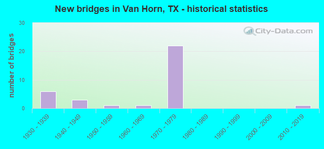
- New bridges - historical statistics
- 61930-1939
- 31940-1949
- 11950-1959
- 11960-1969
- 221970-1979
- 12010-2019
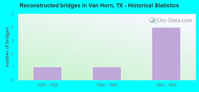
- Reconstructed bridges - Historical Statistics
- 11930-1939
- 11940-1949
- 41950-1959
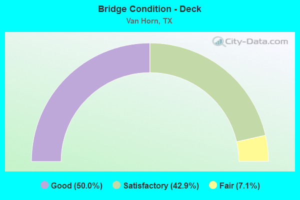
- Bridge Condition - Deck
- 50.0%Good
- 42.9%Satisfactory
- 7.1%Fair
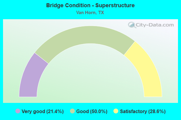
- Bridge Condition - Superstructure
- 21.4%Very good
- 50.0%Good
- 28.6%Satisfactory
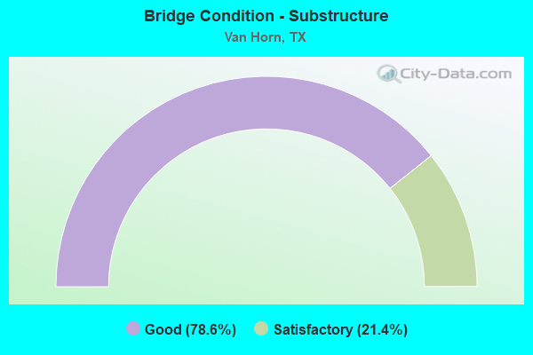
- Bridge Condition - Substructure
- 78.6%Good
- 21.4%Satisfactory
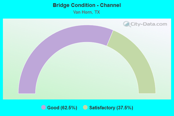
- Bridge Condition - Channel
- 62.5%Good
- 37.5%Satisfactory
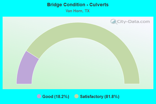
- Bridge Condition - Culverts
- 18.2%Good
- 81.8%Satisfactory
Find on map >> Show street view
Structure Number: 240550000211094, Location: 2.75 MI W OF US 90 (Lat: 31.036672, Lng: -104.877492), Route carried "on" structure: Interstate 10, Year Built: 1957, Status: Open, Structure Length: 7.01m (23.00ft), Average Daily Traffic: 8,715 (year 2019), Truck Traffic: 33%, Average Future Daily Traffic: 11,540 (year 2033), Features Intersected: CARRIZO CREEK
Minimum Vertical Clearance: 30+ m (98+ ft), Kilometerpoint: 4.711, Lanes on structure: 2, Owner: State Highway Agency, Approaching Roadway Width: 11.6m (38.1ft), Skew: 3 degrees, Material/Design: Concrete, Design/Construction: Slab, Number Of Spans In Main Unit: 9, Length of Maximum Span: 7.6m (24.9ft), Curb-To-Curb Width: 11.8m (38.7ft), Out-to-Out Width: 12.8m (42.0ft)
Condition: Deck: Satisfactory, Superstructure: Satisfactory, Substructure: Satisfactory, Channel: Good, Operating Rating: 46.3 metric tons, Method Used To Determine Operating Rating: Load Factor (LF), Inventory Rating: 28.1 metric tons, Method Used To Determine Inventory Rating: Load Factor (LF), Structural Evaluation: Equal to present minimum criteria, Deck Geometry: Equal to present minimum criteria, Waterway Adequacy: Superior to present desirable criteria, Approach Roadway Alignment: Equal to present desirable criteria, Length Of Structure Improvement: 6.98m (22.90ft), Designated Inspection Frequency: Every 24 months, Inspection Date: Febuary 2021, Deck Structure Type: Concrete Cast-file-Place, Wearing Surface/Protective System: Wearing Surface: Bituminous
Find on map >> Show street view
Structure Number: 240550000211152, Location: 1.75 MI W OF US 90 (Lat: 31.035917, Lng: -104.862378), Route carried "on" structure: Business State highway 10, Year Built: 1975, Status: Open, Structure Length: 13.53m (44.39ft), Average Daily Traffic: 3,290 (year 2013), Truck Traffic: 9%, Average Future Daily Traffic: 4,610 (year 2033), Design Load: H 20, Features Intersected: IH 10
Minimum Vertical Clearance: 30+ m (98+ ft), Kilometerpoint: 8.280, Lanes on structure: 1, Lanes under structure: 4, Owner: State Highway Agency, Approaching Roadway Width: 7.6m (24.9ft), Skew: 5 degrees, Material/Design: Steel continuous, Design/Construction: Stringer/Multi-beam, Number Of Spans In Main Unit: 2, Number Of Approach Spans: 2, Length of Maximum Span: 50.6m (166.0ft), Curb-To-Curb Width: 7.3m (24.0ft), Out-to-Out Width: 8.0m (26.2ft)
Condition: Deck: Good, Superstructure: Satisfactory, Substructure: Satisfactory, Operating Rating: 58.0 metric tons, Method Used To Determine Operating Rating: Load Factor (LF), Inventory Rating: 34.5 metric tons, Method Used To Determine Inventory Rating: Load Factor (LF), Structural Evaluation: Equal to present minimum criteria, Deck Geometry: High priority of replacement, Underclear: Somewhat better than minimum adequacy, Approach Roadway Alignment: Equal to present desirable criteria, Designated Inspection Frequency: Every 24 months, Inspection Date: Febuary 2021, Deck Structure Type: Concrete Cast-file-Place, Wearing Surface/Protective System: Wearing Surface: Bituminous
Find on map >> Show street view
Structure Number: 240550000211153, Location: 1.50 MI W OF US 90 (Lat: 31.035494, Lng: -104.856250), Route carried "on" structure: Interstate 10, Year Built: 1975, Status: Open, Structure Length: 4.27m (14.01ft), Average Daily Traffic: 8,692 (year 2019), Truck Traffic: 37%, Average Future Daily Traffic: 8,220 (year 2033), Design Load: HS 20, Features Intersected: GOLF COURSE DRIVE
Minimum Vertical Clearance: 30+ m (98+ ft), Kilometerpoint: 6.753, Lanes on structure: 2, Lanes under structure: 2, Owner: State Highway Agency, Approaching Roadway Width: 11.6m (38.1ft), Material/Design: Prestressed concrete, Design/Construction: Stringer/Multi-beam, Number Of Spans In Main Unit: 1, Number Of Approach Spans: 2, Length of Maximum Span: 18.3m (60.0ft), Curb-To-Curb Width: 12.6m (41.3ft), Out-to-Out Width: 13.5m (44.3ft)
Condition: Deck: Good, Superstructure: Good, Substructure: Good, Operating Rating: 54.4 metric tons, Method Used To Determine Operating Rating: Assigned rating based on Load Factor Design (LFD) reported in metric tons, Inventory Rating: 32.7 metric tons, Method Used To Determine Inventory Rating: Assigned rating based on Load Factor Design (LFD) reported in metric tons, Structural Evaluation: Better than present minimum criteria, Deck Geometry: Better than present minimum criteria, Underclear: Somewhat better than minimum adequacy, Approach Roadway Alignment: Equal to present desirable criteria, Designated Inspection Frequency: Every 24 months, Inspection Date: Febuary 2021, Deck Structure Type: Concrete Cast-file-Place, Wearing Surface/Protective System: Wearing Surface: Bituminous
Find on map >> Show street view
Structure Number: 240550000211154, Location: 1.50 MI W OF US 90 (Lat: 31.035819, Lng: -104.855847), Route carried "on" structure: Interstate 10, Year Built: 1975, Status: Open, Structure Length: 4.27m (14.01ft), Average Daily Traffic: 8,012 (year 2019), Truck Traffic: 37%, Average Future Daily Traffic: 8,220 (year 2033), Design Load: HS 20, Features Intersected: GOLF COURSE DRIVE
Minimum Vertical Clearance: 30+ m (98+ ft), Kilometerpoint: 6.766, Lanes on structure: 2, Lanes under structure: 2, Owner: State Highway Agency, Approaching Roadway Width: 11.6m (38.1ft), Material/Design: Prestressed concrete, Design/Construction: Stringer/Multi-beam, Number Of Spans In Main Unit: 1, Number Of Approach Spans: 2, Length of Maximum Span: 18.3m (60.0ft), Curb-To-Curb Width: 12.6m (41.3ft), Out-to-Out Width: 13.5m (44.3ft)
Condition: Deck: Good, Superstructure: Good, Substructure: Good, Operating Rating: 54.4 metric tons, Method Used To Determine Operating Rating: Assigned rating based on Load Factor Design (LFD) reported in metric tons, Inventory Rating: 32.7 metric tons, Method Used To Determine Inventory Rating: Assigned rating based on Load Factor Design (LFD) reported in metric tons, Structural Evaluation: Better than present minimum criteria, Deck Geometry: Better than present minimum criteria, Underclear: Somewhat better than minimum adequacy, Approach Roadway Alignment: Equal to present desirable criteria, Designated Inspection Frequency: Every 24 months, Inspection Date: Febuary 2021, Deck Structure Type: Concrete Cast-file-Place, Wearing Surface/Protective System: Wearing Surface: Bituminous
Find on map >> Show street view
Structure Number: 240550000211155, Location: 0.80 MI W OF US 90 (Lat: 31.035550, Lng: -104.844325), Route carried "on" structure: Interstate 10, Year Built: 1975, Status: Open, Structure Length: 4.27m (14.01ft), Average Daily Traffic: 8,692 (year 2019), Truck Traffic: 37%, Average Future Daily Traffic: 8,220 (year 2033), Design Load: HS 20, Features Intersected: LAUREL STREET
Minimum Vertical Clearance: 30+ m (98+ ft), Kilometerpoint: 7.891, Lanes on structure: 2, Lanes under structure: 2, Owner: State Highway Agency, Approaching Roadway Width: 12.8m (42.0ft), Material/Design: Prestressed concrete, Design/Construction: Stringer/Multi-beam, Number Of Spans In Main Unit: 1, Number Of Approach Spans: 2, Length of Maximum Span: 18.3m (60.0ft), Curb-To-Curb Width: 12.6m (41.3ft), Out-to-Out Width: 13.5m (44.3ft)
Condition: Deck: Satisfactory, Superstructure: Good, Substructure: Good, Operating Rating: 54.4 metric tons, Method Used To Determine Operating Rating: Assigned rating based on Load Factor Design (LFD) reported in metric tons, Inventory Rating: 32.7 metric tons, Method Used To Determine Inventory Rating: Assigned rating based on Load Factor Design (LFD) reported in metric tons, Structural Evaluation: Better than present minimum criteria, Deck Geometry: Better than present minimum criteria, Underclear: Somewhat better than minimum adequacy, Approach Roadway Alignment: Equal to present desirable criteria, Designated Inspection Frequency: Every 24 months, Inspection Date: Febuary 2021, Deck Structure Type: Concrete Cast-file-Place, Wearing Surface/Protective System: Wearing Surface: Bituminous
Find on map >> Show street view
Structure Number: 240550000211156, Location: 0.80 MI W OF US 90 (Lat: 31.035903, Lng: -104.843925), Route carried "on" structure: Interstate 10, Year Built: 1975, Status: Open, Structure Length: 4.27m (14.01ft), Average Daily Traffic: 8,012 (year 2019), Truck Traffic: 37%, Average Future Daily Traffic: 8,220 (year 2033), Design Load: HS 20, Features Intersected: LAUREL STREET
Minimum Vertical Clearance: 30+ m (98+ ft), Kilometerpoint: 7.892, Lanes on structure: 2, Lanes under structure: 2, Owner: State Highway Agency, Approaching Roadway Width: 12.8m (42.0ft), Material/Design: Prestressed concrete, Design/Construction: Stringer/Multi-beam, Number Of Spans In Main Unit: 1, Number Of Approach Spans: 2, Length of Maximum Span: 18.3m (60.0ft), Curb-To-Curb Width: 12.6m (41.3ft), Out-to-Out Width: 13.5m (44.3ft)
Condition: Deck: Satisfactory, Superstructure: Very good, Substructure: Good, Operating Rating: 54.4 metric tons, Method Used To Determine Operating Rating: Assigned rating based on Load Factor Design (LFD) reported in metric tons, Inventory Rating: 32.7 metric tons, Method Used To Determine Inventory Rating: Assigned rating based on Load Factor Design (LFD) reported in metric tons, Structural Evaluation: Better than present minimum criteria, Deck Geometry: Better than present minimum criteria, Underclear: Somewhat better than minimum adequacy, Approach Roadway Alignment: Equal to present desirable criteria, Designated Inspection Frequency: Every 24 months, Inspection Date: Febuary 2021, Deck Structure Type: Concrete Cast-file-Place, Wearing Surface/Protective System: Wearing Surface: Bituminous
Find on map >> Show street view
Structure Number: 240550000211157, Location: 0.20 MI W OF US 90 (Lat: 31.036414, Lng: -104.834656), Route carried "on" structure: Interstate 10, Year Built: 1975, Status: Open, Structure Length: 1.31m (4.30ft), Average Daily Traffic: 14,700 (year 2020), Truck Traffic: 37%, Average Future Daily Traffic: 16,440 (year 2033), Design Load: HS 20, Features Intersected: DRAINAGE DITCH
Minimum Vertical Clearance: 30+ m (98+ ft), Kilometerpoint: 8.822, Lanes on structure: 9, Owner: State Highway Agency, Approaching Roadway Width: 55.5m (182.1ft), Skew: 20 degrees, Material/Design: Concrete, Design/Construction: Culvert, Number Of Spans In Main Unit: 5, Length of Maximum Span: 2.4m (7.9ft)
Condition: Channel: Satisfactory, Culverts: Satisfactory, Operating Rating: 39.9 metric tons, Method Used To Determine Operating Rating: Load Factor (LF), Inventory Rating: 23.6 metric tons, Method Used To Determine Inventory Rating: Load Factor (LF), Structural Evaluation: Somewhat better than minimum adequacy, Waterway Adequacy: Equal to present minimum criteria, Approach Roadway Alignment: Equal to present desirable criteria, Designated Inspection Frequency: Every 48 months, Inspection Date: Febuary 2019
Find on map >> Show street view
Structure Number: 240550000211164, Location: JCT IH 10 & US 90 (Lat: 31.036644, Lng: -104.831172), Route carried "on" structure: Interstate 10, Year Built: 1975, Status: Open, Structure Length: 5.18m (16.99ft), Average Daily Traffic: 8,692 (year 2019), Truck Traffic: 37%, Average Future Daily Traffic: 8,220 (year 2033), Design Load: HS 20, Features Intersected: US 90 / SH 54
Minimum Vertical Clearance: 30+ m (98+ ft), Kilometerpoint: 9.156, Lanes on structure: 2, Lanes under structure: 3, Owner: State Highway Agency, Approaching Roadway Width: 11.6m (38.1ft), Material/Design: Prestressed concrete, Design/Construction: Stringer/Multi-beam, Number Of Spans In Main Unit: 1, Number Of Approach Spans: 2, Length of Maximum Span: 27.4m (89.9ft), Curb-To-Curb Width: 12.6m (41.3ft), Out-to-Out Width: 13.5m (44.3ft)
Condition: Deck: Good, Superstructure: Very good, Substructure: Good, Operating Rating: 54.4 metric tons, Method Used To Determine Operating Rating: Assigned rating based on Load Factor Design (LFD) reported in metric tons, Inventory Rating: 32.7 metric tons, Method Used To Determine Inventory Rating: Assigned rating based on Load Factor Design (LFD) reported in metric tons, Structural Evaluation: Better than present minimum criteria, Deck Geometry: Better than present minimum criteria, Underclear: Better than present minimum criteria, Approach Roadway Alignment: Equal to present desirable criteria, Designated Inspection Frequency: Every 24 months, Inspection Date: Febuary 2021, Deck Structure Type: Concrete Cast-file-Place, Wearing Surface/Protective System: Wearing Surface: Bituminous
Find on map >> Show street view
Structure Number: 240550000211165, Location: JCT IH 10 & US 90 (Lat: 31.037022, Lng: -104.830678), Route carried "on" structure: Interstate 10, Year Built: 1975, Status: Open, Structure Length: 5.18m (16.99ft), Average Daily Traffic: 6,975 (year 2019), Truck Traffic: 37%, Average Future Daily Traffic: 8,220 (year 2033), Design Load: HS 20, Features Intersected: US 90 / SH 54
Minimum Vertical Clearance: 30+ m (98+ ft), Kilometerpoint: 9.156, Lanes on structure: 2, Lanes under structure: 3, Owner: State Highway Agency, Approaching Roadway Width: 11.6m (38.1ft), Material/Design: Prestressed concrete, Design/Construction: Stringer/Multi-beam, Number Of Spans In Main Unit: 1, Number Of Approach Spans: 2, Length of Maximum Span: 27.4m (89.9ft), Curb-To-Curb Width: 12.6m (41.3ft), Out-to-Out Width: 13.5m (44.3ft)
Condition: Deck: Satisfactory, Superstructure: Good, Substructure: Good, Operating Rating: 54.4 metric tons, Method Used To Determine Operating Rating: Assigned rating based on Load Factor Design (LFD) reported in metric tons, Inventory Rating: 32.7 metric tons, Method Used To Determine Inventory Rating: Assigned rating based on Load Factor Design (LFD) reported in metric tons, Structural Evaluation: Better than present minimum criteria, Deck Geometry: Better than present minimum criteria, Underclear: Better than present minimum criteria, Approach Roadway Alignment: Equal to present desirable criteria, Designated Inspection Frequency: Every 24 months, Inspection Date: Febuary 2021, Deck Structure Type: Concrete Cast-file-Place, Wearing Surface/Protective System: Wearing Surface: Bituminous
Find on map >> Show street view
Structure Number: 240550000211273, Location: 2.75 MI W OF US 90 (Lat: 31.037083, Lng: -104.877078), Route carried "on" structure: Interstate 10, Year Built: 2010, Status: Open, Structure Length: 7.01m (23.00ft), Average Daily Traffic: 8,387 (year 2019), Truck Traffic: 51%, Average Future Daily Traffic: 8,400 (year 2031), Design Load: HS 20, Features Intersected: CARRIZO CREEK
Minimum Vertical Clearance: 30+ m (98+ ft), Kilometerpoint: 4.764, Lanes on structure: 2, Owner: State Highway Agency, Approaching Roadway Width: 11.6m (38.1ft), Skew: 3 degrees, Material/Design: Prestressed concrete, Design/Construction: Box Beam or Girders - Multiple, Number Of Spans In Main Unit: 3, Length of Maximum Span: 23.5m (77.1ft), Curb-To-Curb Width: 11.3m (37.1ft), Out-to-Out Width: 12.2m (40.0ft)
Condition: Deck: Fair, Superstructure: Satisfactory, Substructure: Good, Channel: Good, Operating Rating: 54.4 metric tons, Method Used To Determine Operating Rating: Assigned rating based on Load Factor Design (LFD) reported in metric tons, Inventory Rating: 32.7 metric tons, Method Used To Determine Inventory Rating: Assigned rating based on Load Factor Design (LFD) reported in metric tons, Structural Evaluation: Equal to present minimum criteria, Deck Geometry: Somewhat better than minimum adequacy, Waterway Adequacy: Superior to present desirable criteria, Approach Roadway Alignment: Equal to present desirable criteria, Designated Inspection Frequency: Every 24 months, Inspection Date: Febuary 2021, Deck Structure Type: Concrete Cast-file-Place
Find on map >> Show street view
Structure Number: 240550000220056, Location: 0.20 MI W OF US 90 (Lat: 31.039392, Lng: -104.835028), Route carried "on" structure: State highway 10, Year Built: 1930, Year Reconstructed: 1938, Status: Open, Structure Length: 1.52m (4.99ft), Average Daily Traffic: 3,290 (year 2013), Truck Traffic: 9%, Average Future Daily Traffic: 4,610 (year 2033), Design Load: H 15, Features Intersected: DRAINAGE DITCH
Minimum Vertical Clearance: 30+ m (98+ ft), Kilometerpoint: 10.950, Lanes on structure: 4, Owner: State Highway Agency, Approaching Roadway Width: 23.2m (76.1ft), Material/Design: Concrete, Design/Construction: Culvert, Number Of Spans In Main Unit: 14, Length of Maximum Span: 0.9m (3.0ft), Curb-To-Curb Width: 23.2m (76.1ft), Out-to-Out Width: 23.7m (77.8ft)
Condition: Channel: Good, Culverts: Satisfactory, Operating Rating: 39.9 metric tons, Method Used To Determine Operating Rating: Load Factor (LF), Inventory Rating: 23.6 metric tons, Method Used To Determine Inventory Rating: Load Factor (LF), Structural Evaluation: Equal to present minimum criteria, Deck Geometry: Superior to present desirable criteria, Waterway Adequacy: Equal to present minimum criteria, Approach Roadway Alignment: Equal to present desirable criteria, Designated Inspection Frequency: Every 24 months, Inspection Date: Febuary 2021, Deck Structure Type: Concrete Cast-file-Place, Wearing Surface/Protective System: Wearing Surface: Bituminous
Find on map >> Show street view
Structure Number: 240550000301001, Location: 4.20 MI E OF US 90 (Lat: 31.044872, Lng: -104.760458), Route carried "on" structure: ServiceInterstate 10, Year Built: 1931, Year Reconstructed: 1952, Status: Open, Structure Length: 8.69m (28.51ft), Average Daily Traffic: 20 (year 2013), Truck Traffic: 44%, Average Future Daily Traffic: 30 (year 2033), Design Load: H 15, Features Intersected: WILD HORSE CREEK
Minimum Vertical Clearance: 30+ m (98+ ft), Kilometerpoint: 14.653, Lanes on structure: 2, Owner: State Highway Agency, Approaching Roadway Width: 13.4m (44.0ft), Material/Design: Concrete, Design/Construction: Tee Beam, Number Of Spans In Main Unit: 10, Length of Maximum Span: 8.5m (27.9ft), Curb-To-Curb Width: 13.4m (44.0ft), Out-to-Out Width: 14.0m (45.9ft)
Condition: Deck: Satisfactory, Superstructure: Satisfactory, Substructure: Satisfactory, Channel: Good, Operating Rating: 51.7 metric tons, Method Used To Determine Operating Rating: Load Factor (LF), Inventory Rating: 30.8 metric tons, Method Used To Determine Inventory Rating: Load Factor (LF), Structural Evaluation: Equal to present minimum criteria, Deck Geometry: Superior to present desirable criteria, Waterway Adequacy: Better than present minimum criteria, Approach Roadway Alignment: Equal to present desirable criteria, Designated Inspection Frequency: Every 24 months, Inspection Date: Febuary 2021, Deck Structure Type: Concrete Cast-file-Place, Wearing Surface/Protective System: Wearing Surface: Bituminous
Find on map >> Show street view
Structure Number: 240550000301156, Location: 4.20 MI E OF US 90 (Lat: 31.043958, Lng: -104.762208), Route carried "on" structure: Interstate 10, Year Built: 1974, Status: Open, Structure Length: 10.67m (35.01ft), Average Daily Traffic: 8,477 (year 2019), Truck Traffic: 62%, Average Future Daily Traffic: 7,430 (year 2033), Design Load: HS 20, Features Intersected: WILD HORSE CREEK
Minimum Vertical Clearance: 30+ m (98+ ft), Kilometerpoint: 14.632, Lanes on structure: 2, Owner: State Highway Agency, Approaching Roadway Width: 11.6m (38.1ft), Skew: 3 degrees, Material/Design: Prestressed concrete, Design/Construction: Stringer/Multi-beam, Number Of Spans In Main Unit: 5, Length of Maximum Span: 21.3m (69.9ft), Curb-To-Curb Width: 12.6m (41.3ft), Out-to-Out Width: 13.5m (44.3ft)
Condition: Deck: Good, Superstructure: Good, Substructure: Good, Channel: Good, Operating Rating: 54.4 metric tons, Method Used To Determine Operating Rating: Assigned rating based on Load Factor Design (LFD) reported in metric tons, Inventory Rating: 32.7 metric tons, Method Used To Determine Inventory Rating: Assigned rating based on Load Factor Design (LFD) reported in metric tons, Structural Evaluation: Better than present minimum criteria, Deck Geometry: Better than present minimum criteria, Waterway Adequacy: Superior to present desirable criteria, Approach Roadway Alignment: Equal to present desirable criteria, Designated Inspection Frequency: Every 24 months, Inspection Date: Febuary 2021, Deck Structure Type: Concrete Cast-file-Place, Wearing Surface/Protective System: Wearing Surface: Bituminous
Find on map >> Show street view
Structure Number: 240550000301157, Location: 4.20 MI E OF US 90 (Lat: 31.044222, Lng: -104.760806), Route carried "on" structure: Interstate 10, Year Built: 1974, Status: Open, Structure Length: 10.67m (35.01ft), Average Daily Traffic: 7,766 (year 2019), Truck Traffic: 62%, Average Future Daily Traffic: 7,430 (year 2033), Design Load: HS 20, Features Intersected: WILD HORSE CREEK
Minimum Vertical Clearance: 30+ m (98+ ft), Kilometerpoint: 14.653, Lanes on structure: 2, Owner: State Highway Agency, Approaching Roadway Width: 11.6m (38.1ft), Skew: 3 degrees, Material/Design: Prestressed concrete, Design/Construction: Stringer/Multi-beam, Number Of Spans In Main Unit: 5, Length of Maximum Span: 21.3m (69.9ft), Curb-To-Curb Width: 12.6m (41.3ft), Out-to-Out Width: 13.5m (44.3ft)
Condition: Deck: Good, Superstructure: Good, Substructure: Good, Channel: Good, Operating Rating: 54.4 metric tons, Method Used To Determine Operating Rating: Assigned rating based on Load Factor Design (LFD) reported in metric tons, Inventory Rating: 32.7 metric tons, Method Used To Determine Inventory Rating: Assigned rating based on Load Factor Design (LFD) reported in metric tons, Structural Evaluation: Better than present minimum criteria, Deck Geometry: Better than present minimum criteria, Waterway Adequacy: Superior to present desirable criteria, Approach Roadway Alignment: Equal to present desirable criteria, Designated Inspection Frequency: Every 24 months, Inspection Date: Febuary 2021, Deck Structure Type: Concrete Cast-file-Place, Wearing Surface/Protective System: Wearing Surface: Bituminous
Find on map >> Show street view
Structure Number: 240550000301178, Location: 0.80 MI E OF US 90 (Lat: 31.039650, Lng: -104.817389), Route carried "on" structure: Interstate 10, Year Built: 1975, Status: Open, Structure Length: 5.18m (16.99ft), Average Daily Traffic: 8,475 (year 2019), Truck Traffic: 62%, Average Future Daily Traffic: 7,430 (year 2033), Design Load: HS 20, Features Intersected: IH 10 BUS LP (ROSS DR)
Minimum Vertical Clearance: 30+ m (98+ ft), Kilometerpoint: 9.339, Lanes on structure: 2, Lanes under structure: 2, Owner: State Highway Agency, Approaching Roadway Width: 11.6m (38.1ft), Skew: 3 degrees, Material/Design: Prestressed concrete, Design/Construction: Stringer/Multi-beam, Number Of Spans In Main Unit: 3, Length of Maximum Span: 21.3m (69.9ft), Curb-To-Curb Width: 12.6m (41.3ft), Out-to-Out Width: 13.5m (44.3ft)
Condition: Deck: Satisfactory, Superstructure: Very good, Substructure: Good, Operating Rating: 54.4 metric tons, Method Used To Determine Operating Rating: Assigned rating based on Load Factor Design (LFD) reported in metric tons, Inventory Rating: 32.7 metric tons, Method Used To Determine Inventory Rating: Assigned rating based on Load Factor Design (LFD) reported in metric tons, Structural Evaluation: Better than present minimum criteria, Deck Geometry: Better than present minimum criteria, Underclear: Superior to present desirable criteria, Approach Roadway Alignment: Equal to present desirable criteria, Designated Inspection Frequency: Every 24 months, Inspection Date: Febuary 2021, Deck Structure Type: Concrete Cast-file-Place, Wearing Surface/Protective System: Wearing Surface: Bituminous
Find on map >> Show street view
Structure Number: 24055000030118, Location: 0.80 MI E OF US 90 (Lat: 31.040039, Lng: -104.817267), Route carried "on" structure: Interstate 10, Year Built: 1975, Status: Open, Structure Length: 5.18m (16.99ft), Average Daily Traffic: 7,766 (year 2019), Truck Traffic: 42%, Average Future Daily Traffic: 7,190 (year 2033), Design Load: HS 20, Features Intersected: IH 10 BUS LP (ROSS DR)
Minimum Vertical Clearance: 30+ m (98+ ft), Kilometerpoint: 9.325, Lanes on structure: 2, Lanes under structure: 2, Owner: State Highway Agency, Approaching Roadway Width: 11.6m (38.1ft), Skew: 3 degrees, Material/Design: Prestressed concrete, Design/Construction: Stringer/Multi-beam, Number Of Spans In Main Unit: 3, Length of Maximum Span: 21.3m (69.9ft), Curb-To-Curb Width: 12.6m (41.3ft), Out-to-Out Width: 13.5m (44.3ft)
Condition: Deck: Good, Superstructure: Good, Substructure: Good, Operating Rating: 54.4 metric tons, Method Used To Determine Operating Rating: Assigned rating based on Load Factor Design (LFD) reported in metric tons, Inventory Rating: 32.7 metric tons, Method Used To Determine Inventory Rating: Assigned rating based on Load Factor Design (LFD) reported in metric tons, Structural Evaluation: Better than present minimum criteria, Deck Geometry: Better than present minimum criteria, Underclear: Better than present minimum criteria, Approach Roadway Alignment: Equal to present desirable criteria, Designated Inspection Frequency: Every 24 months, Inspection Date: Febuary 2021, Deck Structure Type: Concrete Cast-file-Place, Wearing Surface/Protective System: Wearing Surface: Bituminous
Find on map >> Show street view
Structure Number: 240550002001069, Location: 0.30 MI S OF IH 10 (Lat: 31.032386, Lng: -104.830386), Route carried "on" structure: US 90, Year Built: 1937, Year Reconstructed: 1958, Status: Open, Structure Length: 0.79m (2.59ft), Average Daily Traffic: 3,953 (year 2020), Truck Traffic: 15%, Average Future Daily Traffic: 6,310 (year 2033), Design Load: H 15, Features Intersected: DRAW
Minimum Vertical Clearance: 30+ m (98+ ft), Kilometerpoint: 0.824, Lanes on structure: 2, Owner: State Highway Agency, Approaching Roadway Width: 10.4m (34.1ft), Material/Design: Concrete, Design/Construction: Culvert, Number Of Spans In Main Unit: 4, Length of Maximum Span: 1.8m (5.9ft), Curb-To-Curb Width: 10.4m (34.1ft), Out-to-Out Width: 17.5m (57.4ft)
Condition: Channel: Satisfactory, Culverts: Good, Operating Rating: 39.9 metric tons, Method Used To Determine Operating Rating: Load Factor (LF), Inventory Rating: 23.6 metric tons, Method Used To Determine Inventory Rating: Load Factor (LF), Structural Evaluation: Equal to present minimum criteria, Deck Geometry: Somewhat better than minimum adequacy, Waterway Adequacy: Equal to present minimum criteria, Approach Roadway Alignment: Equal to present desirable criteria, Designated Inspection Frequency: Every 24 months, Inspection Date: Febuary 2021, Deck Structure Type: Concrete Cast-file-Place, Wearing Surface/Protective System: Wearing Surface: Bituminous
Find on map >> Show street view
Structure Number: 24055000200107, Location: 3.00 MI S OF IH 10 (Lat: 30.993397, Lng: -104.822697), Route carried "on" structure: US 90, Year Built: 1937, Year Reconstructed: 1958, Status: Open, Structure Length: 4.39m (14.40ft), Average Daily Traffic: 1,037 (year 2020), Truck Traffic: 15%, Average Future Daily Traffic: 1,610 (year 2033), Design Load: H 15, Features Intersected: DRAW
Minimum Vertical Clearance: 30+ m (98+ ft), Kilometerpoint: 5.209, Lanes on structure: 2, Owner: State Highway Agency, Approaching Roadway Width: 10.4m (34.1ft), Material/Design: Concrete, Design/Construction: Culvert, Number Of Spans In Main Unit: 19, Length of Maximum Span: 2.1m (6.9ft), Curb-To-Curb Width: 13.3m (43.6ft), Out-to-Out Width: 13.8m (45.3ft)
Condition: Channel: Good, Culverts: Satisfactory, Operating Rating: 39.9 metric tons, Method Used To Determine Operating Rating: Load Factor (LF), Inventory Rating: 23.6 metric tons, Method Used To Determine Inventory Rating: Load Factor (LF), Structural Evaluation: Equal to present minimum criteria, Deck Geometry: Better than present minimum criteria, Waterway Adequacy: Equal to present minimum criteria, Approach Roadway Alignment: Equal to present desirable criteria, Designated Inspection Frequency: Every 24 months, Inspection Date: Febuary 2021, Deck Structure Type: Concrete Cast-file-Place, Wearing Surface/Protective System: Wearing Surface: Bituminous
Find on map >> Show street view
Structure Number: 240550002001071, Location: 3.25 MI S OF IH 10 (Lat: 30.989825, Lng: -104.821917), Route carried "on" structure: US 90, Year Built: 1937, Year Reconstructed: 1958, Status: Open, Structure Length: 4.39m (14.40ft), Average Daily Traffic: 1,037 (year 2020), Truck Traffic: 15%, Average Future Daily Traffic: 1,610 (year 2033), Design Load: H 15, Features Intersected: DRAW
Minimum Vertical Clearance: 30+ m (98+ ft), Kilometerpoint: 5.631, Lanes on structure: 2, Owner: State Highway Agency, Approaching Roadway Width: 10.4m (34.1ft), Material/Design: Concrete, Design/Construction: Culvert, Number Of Spans In Main Unit: 19, Length of Maximum Span: 2.1m (6.9ft), Curb-To-Curb Width: 13.3m (43.6ft), Out-to-Out Width: 13.8m (45.3ft)
Condition: Channel: Satisfactory, Culverts: Satisfactory, Operating Rating: 39.9 metric tons, Method Used To Determine Operating Rating: Load Factor (LF), Inventory Rating: 23.6 metric tons, Method Used To Determine Inventory Rating: Load Factor (LF), Structural Evaluation: Equal to present minimum criteria, Deck Geometry: Better than present minimum criteria, Waterway Adequacy: Equal to present minimum criteria, Approach Roadway Alignment: Equal to present desirable criteria, Designated Inspection Frequency: Every 24 months, Inspection Date: Febuary 2021, Deck Structure Type: Concrete Cast-file-Place, Wearing Surface/Protective System: Wearing Surface: Bituminous
Find on map >> Show street view
Structure Number: 240550002001072, Location: 4.00 MI S OF IH 10 (Lat: 30.979381, Lng: -104.819625), Route carried "on" structure: US 90, Year Built: 1937, Year Reconstructed: 1958, Status: Open, Structure Length: 4.39m (14.40ft), Average Daily Traffic: 638 (year 2020), Truck Traffic: 15%, Average Future Daily Traffic: 1,150 (year 2033), Design Load: H 15, Features Intersected: DRAW
Minimum Vertical Clearance: 30+ m (98+ ft), Kilometerpoint: 6.790, Lanes on structure: 2, Owner: State Highway Agency, Approaching Roadway Width: 10.4m (34.1ft), Material/Design: Concrete, Design/Construction: Culvert, Number Of Spans In Main Unit: 19, Length of Maximum Span: 2.1m (6.9ft), Curb-To-Curb Width: 13.4m (44.0ft), Out-to-Out Width: 13.8m (45.3ft)
Condition: Channel: Satisfactory, Culverts: Satisfactory, Operating Rating: 39.9 metric tons, Method Used To Determine Operating Rating: Load Factor (LF), Inventory Rating: 23.6 metric tons, Method Used To Determine Inventory Rating: Load Factor (LF), Structural Evaluation: Equal to present minimum criteria, Deck Geometry: Superior to present desirable criteria, Waterway Adequacy: Equal to present minimum criteria, Approach Roadway Alignment: Equal to present desirable criteria, Designated Inspection Frequency: Every 24 months, Inspection Date: Febuary 2021, Deck Structure Type: Concrete Cast-file-Place, Wearing Surface/Protective System: Wearing Surface: Bituminous
Find on map >> Show street view
Structure Number: 240550002001161, Location: 0.15 MI S OF IH 10 (Lat: 31.034472, Lng: -104.830631), Route carried "on" structure: US 90, Year Built: 1975, Status: Open, Structure Length: 1.28m (4.20ft), Average Daily Traffic: 3,953 (year 2020), Truck Traffic: 15%, Average Future Daily Traffic: 6,310 (year 2033), Design Load: HS 20, Features Intersected: DRAINAGE DITCH
Minimum Vertical Clearance: 30+ m (98+ ft), Kilometerpoint: 0.576, Lanes on structure: 2, Owner: State Highway Agency, Approaching Roadway Width: 10.4m (34.1ft), Material/Design: Concrete, Design/Construction: Culvert, Number Of Spans In Main Unit: 5, Length of Maximum Span: 2.4m (7.9ft), Curb-To-Curb Width: 10.4m (34.1ft), Out-to-Out Width: 17.5m (57.4ft)
Condition: Channel: Good, Culverts: Good, Operating Rating: 39.9 metric tons, Method Used To Determine Operating Rating: Load Factor (LF), Inventory Rating: 23.6 metric tons, Method Used To Determine Inventory Rating: Load Factor (LF), Structural Evaluation: Equal to present minimum criteria, Deck Geometry: Somewhat better than minimum adequacy, Waterway Adequacy: Equal to present minimum criteria, Approach Roadway Alignment: Equal to present desirable criteria, Designated Inspection Frequency: Every 24 months, Inspection Date: Febuary 2021, Deck Structure Type: Concrete Cast-file-Place, Wearing Surface/Protective System: Wearing Surface: Bituminous
Find on map >> Show street view
Structure Number: 240550023305026, Location: 2.50 MI N OF IH 10 BUS (Lat: 31.075661, Lng: -104.824403), Route carried "on" structure: State highway 54, Year Built: 1940, Status: Open, Structure Length: 0.82m (2.69ft), Average Daily Traffic: 822 (year 2020), Truck Traffic: 24%, Average Future Daily Traffic: 440 (year 2033), Design Load: H 15, Features Intersected: DRAW
Minimum Vertical Clearance: 30+ m (98+ ft), Kilometerpoint: 82.003, Lanes on structure: 2, Owner: State Highway Agency, Approaching Roadway Width: 9.1m (29.9ft), Skew: 3 degrees, Material/Design: Concrete, Design/Construction: Culvert, Number Of Spans In Main Unit: 3, Length of Maximum Span: 2.1m (6.9ft), Curb-To-Curb Width: 9.8m (32.2ft), Out-to-Out Width: 11.0m (36.1ft)
Condition: Channel: Good, Culverts: Satisfactory, Operating Rating: 39.9 metric tons, Method Used To Determine Operating Rating: Load Factor (LF), Inventory Rating: 23.6 metric tons, Method Used To Determine Inventory Rating: Load Factor (LF), Structural Evaluation: Equal to present minimum criteria, Deck Geometry: Equal to present minimum criteria, Waterway Adequacy: Equal to present minimum criteria, Approach Roadway Alignment: Equal to present desirable criteria, Designated Inspection Frequency: Every 24 months, Inspection Date: Febuary 2021, Deck Structure Type: Concrete Cast-file-Place, Wearing Surface/Protective System: Wearing Surface: Bituminous
Find on map >> Show street view
Structure Number: 240550023305027, Location: 2.15 MI N OF IH 10 BUS (Lat: 31.070433, Lng: -104.826111), Route carried "on" structure: State highway 54, Year Built: 1940, Status: Open, Structure Length: 2.56m (8.40ft), Average Daily Traffic: 822 (year 2020), Truck Traffic: 24%, Average Future Daily Traffic: 440 (year 2033), Design Load: H 15, Features Intersected: HACKBERRY CREEK
Minimum Vertical Clearance: 30+ m (98+ ft), Kilometerpoint: 82.629, Lanes on structure: 2, Owner: State Highway Agency, Approaching Roadway Width: 9.8m (32.2ft), Material/Design: Concrete, Design/Construction: Culvert, Number Of Spans In Main Unit: 11, Length of Maximum Span: 2.1m (6.9ft), Curb-To-Curb Width: 7.3m (24.0ft), Out-to-Out Width: 8.0m (26.2ft)
Condition: Channel: Satisfactory, Culverts: Satisfactory, Operating Rating: 39.9 metric tons, Method Used To Determine Operating Rating: Load Factor (LF), Inventory Rating: 23.6 metric tons, Method Used To Determine Inventory Rating: Load Factor (LF), Structural Evaluation: Equal to present minimum criteria, Deck Geometry: Meets minimum limits, Waterway Adequacy: Equal to present minimum criteria, Approach Roadway Alignment: Equal to present desirable criteria, Designated Inspection Frequency: Every 24 months, Inspection Date: Febuary 2021, Deck Structure Type: Concrete Cast-file-Place, Wearing Surface/Protective System: Wearing Surface: Bituminous
Find on map >> Show street view
Structure Number: 240550023305028, Location: 1.40 MI N OF IH 10 BUS (Lat: 31.060508, Lng: -104.829353), Route carried "on" structure: State highway 54, Year Built: 1940, Status: Open, Structure Length: 2.96m (9.71ft), Average Daily Traffic: 822 (year 2020), Truck Traffic: 24%, Average Future Daily Traffic: 440 (year 2033), Design Load: H 15, Features Intersected: DRAW
Minimum Vertical Clearance: 30+ m (98+ ft), Kilometerpoint: 83.768, Lanes on structure: 2, Owner: State Highway Agency, Approaching Roadway Width: 9.8m (32.2ft), Skew: 4 degrees, Material/Design: Concrete, Design/Construction: Culvert, Number Of Spans In Main Unit: 9, Length of Maximum Span: 2.1m (6.9ft), Curb-To-Curb Width: 7.5m (24.6ft), Out-to-Out Width: 8.2m (26.9ft)
Condition: Channel: Satisfactory, Culverts: Satisfactory, Operating Rating: 39.9 metric tons, Method Used To Determine Operating Rating: Load Factor (LF), Inventory Rating: 23.6 metric tons, Method Used To Determine Inventory Rating: Load Factor (LF), Structural Evaluation: Equal to present minimum criteria, Deck Geometry: Meets minimum limits, Waterway Adequacy: Equal to present minimum criteria, Approach Roadway Alignment: Equal to present desirable criteria, Designated Inspection Frequency: Every 24 months, Inspection Date: Febuary 2021, Deck Structure Type: Concrete Cast-file-Place, Wearing Surface/Protective System: Wearing Surface: Bituminous
Find on map >> Show street view
Structure Number: 240550B00020001, Location: 0.20 MI W OF US 90 (Lat: 31.037897, Lng: -104.834775), Route carried "on" structure: City street , Year Built: 1967, Status: Open, Structure Length: 1.24m (4.07ft), Average Daily Traffic: 430 (year 2010), Truck Traffic: 10%, Average Future Daily Traffic: 750 (year 2030), Features Intersected: DRAINAGE DITCH, Facility Carried by Structure: DESERT ST
Minimum Vertical Clearance: 30+ m (98+ ft), Kilometerpoint: 1.722, Lanes on structure: 2, Owner: City or Municipal Highway Agency, Approaching Roadway Width: 8.5m (27.9ft), Material/Design: Concrete, Design/Construction: Culvert, Number Of Spans In Main Unit: 6, Length of Maximum Span: 1.8m (5.9ft), Curb-To-Curb Width: 9.4m (30.8ft), Out-to-Out Width: 9.8m (32.2ft)
Condition: Channel: Good, Culverts: Satisfactory, Operating Rating: 32.7 metric tons, Method Used To Determine Operating Rating: Field evaluation and documented engineering judgment, Inventory Rating: 24.5 metric tons, Method Used To Determine Inventory Rating: Field evaluation and documented engineering judgment, Structural Evaluation: Equal to present minimum criteria, Deck Geometry: Equal to present minimum criteria, Waterway Adequacy: Better than present minimum criteria, Approach Roadway Alignment: Equal to present desirable criteria, Designated Inspection Frequency: Every 24 months, Inspection Date: April 2020, Deck Structure Type: Concrete Cast-file-Place, Wearing Surface/Protective System: Wearing Surface: Bituminous
Find on map >> Show street view
Structure Number: 240550000211152, Location: 1.75 MI W OF US 90 (Lat: 31.035917, Lng: -104.862378), Route carried "under" structure: Interstate 10, Year Built: 1975, Structure Length: 0. m, Average Daily Traffic: 11,740 (year 2013), Truck Traffic: 37%, Features Intersected: IH 10
Minimum Vertical Clearance: 5.21m (17.09ft), Kilometerpoint: 6.198, Lanes on structure: 1, Lanes under structure: 4, Material/Design: Steel continuous, Design/Construction: Stringer/Multi-beam, Length of Maximum Span: 50.6m (166.0ft)
Find on map >> Show street view
Structure Number: 240550000211153, Location: 1.50 MI W OF US 90 (Lat: 31.035494, Lng: -104.856250), Route carried "under" structure: City street , Year Built: 1975, Structure Length: 0. m, Average Daily Traffic: 1,000 (year 2015), Truck Traffic: 5%, Features Intersected: GOLF COURSE DRIVE, Facility Carried by Structure: IH 10 EB
Minimum Vertical Clearance: 4.88m (16.01ft), Kilometerpoint: 0.161, Lanes on structure: 2, Lanes under structure: 2, Material/Design: Prestressed concrete, Design/Construction: Stringer/Multi-beam, Length of Maximum Span: 18.3m (60.0ft)
Find on map >> Show street view
Structure Number: 240550000211154, Location: 1.50 MI W OF US 90 (Lat: 31.035819, Lng: -104.855847), Route carried "under" structure: City street , Year Built: 1975, Structure Length: 0. m, Average Daily Traffic: 1,000 (year 2015), Truck Traffic: 5%, Features Intersected: GOLF COURSE DRIVE, Facility Carried by Structure: IH 10 WB
Minimum Vertical Clearance: 4.88m (16.01ft), Kilometerpoint: 0.161, Lanes on structure: 2, Lanes under structure: 2, Material/Design: Prestressed concrete, Design/Construction: Stringer/Multi-beam, Length of Maximum Span: 18.3m (60.0ft)
Find on map >> Show street view
Structure Number: 240550000211155, Location: 0.80 MI W OF US 90 (Lat: 31.035550, Lng: -104.844325), Route carried "under" structure: City street , Year Built: 1975, Structure Length: 0. m, Average Daily Traffic: 1,000 (year 2011), Features Intersected: LAUREL STREET, Facility Carried by Structure: IH 10 EB
Minimum Vertical Clearance: 4.72m (15.49ft), Kilometerpoint: 0.348, Lanes on structure: 2, Lanes under structure: 2, Material/Design: Prestressed concrete, Design/Construction: Stringer/Multi-beam, Length of Maximum Span: 18.3m (60.0ft)
Find on map >> Show street view
Structure Number: 240550000211156, Location: 0.80 MI W OF US 90 (Lat: 31.035903, Lng: -104.843925), Route carried "under" structure: City street , Year Built: 1975, Structure Length: 0. m, Average Daily Traffic: 1,000 (year 2011), Features Intersected: LAUREL STREET, Facility Carried by Structure: IH 10 WB
Minimum Vertical Clearance: 4.72m (15.49ft), Kilometerpoint: 0.320, Lanes on structure: 2, Lanes under structure: 2, Material/Design: Prestressed concrete, Design/Construction: Stringer/Multi-beam, Length of Maximum Span: 18.3m (60.0ft)
Find on map >> Show street view
Structure Number: 240550000211164, Location: JCT IH 10 & US 90 (Lat: 31.036644, Lng: -104.831172), Route carried "under" structure: US 90, Year Built: 1975, Structure Length: 0. m, Average Daily Traffic: 2,400 (year 2011), Truck Traffic: 18%, Features Intersected: US 90 / SH 54, Facility Carried by Structure: IH 10 EB
Minimum Vertical Clearance: 5.26m (17.26ft), Kilometerpoint: 0.346, Lanes on structure: 2, Lanes under structure: 3, Material/Design: Prestressed concrete, Design/Construction: Stringer/Multi-beam, Length of Maximum Span: 27.4m (89.9ft)
Find on map >> Show street view
Structure Number: 240550000211165, Location: JCT IH 10 & US 90 (Lat: 31.037022, Lng: -104.830678), Route carried "under" structure: US 90, Year Built: 1975, Structure Length: 0. m, Average Daily Traffic: 2,300 (year 2011), Truck Traffic: 18%, Features Intersected: US 90 / SH 54, Facility Carried by Structure: IH 10 WB
Minimum Vertical Clearance: 5.13m (16.83ft), Kilometerpoint: 0.319, Lanes on structure: 2, Lanes under structure: 3, Material/Design: Prestressed concrete, Design/Construction: Stringer/Multi-beam, Length of Maximum Span: 27.4m (89.9ft)
Find on map >> Show street view
Structure Number: 240550000301178, Location: 0.80 MI E OF US 90 (Lat: 31.039650, Lng: -104.817389), Route carried "under" structure: Business State highway 10, Year Built: 1975, Structure Length: 0. m, Average Daily Traffic: 1,950 (year 2011), Truck Traffic: 10%, Features Intersected: IH 10 BUS LP (ROSS DR)
Minimum Vertical Clearance: 5.26m (17.26ft), Kilometerpoint: 12.707, Lanes on structure: 2, Lanes under structure: 2, Material/Design: Prestressed concrete, Design/Construction: Stringer/Multi-beam, Length of Maximum Span: 21.3m (69.9ft)
Find on map >> Show street view
Structure Number: 24055000030118, Location: 0.80 MI E OF US 90 (Lat: 31.040039, Lng: -104.817267), Route carried "under" structure: Business State highway 10, Year Built: 1975, Structure Length: 0. m, Average Daily Traffic: 1,950 (year 2015), Truck Traffic: 10%, Features Intersected: IH 10 BUS LP (ROSS DR)
Minimum Vertical Clearance: 4.98m (16.34ft), Kilometerpoint: 12.667, Lanes on structure: 2, Lanes under structure: 2, Material/Design: Prestressed concrete, Design/Construction: Stringer/Multi-beam, Length of Maximum Span: 21.3m (69.9ft)