Bridge Statistics for Verona, Kentucky (KY)
Condition, Traffic, Stress, Structural Evaluation, Project Costs
- National Bridge Inventory (NBI) Statistics
- 31Number of bridges
- 266ft / 80.8mTotal length
- $1,733,000Total costs
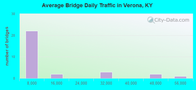
- 286,141Total average daily traffic
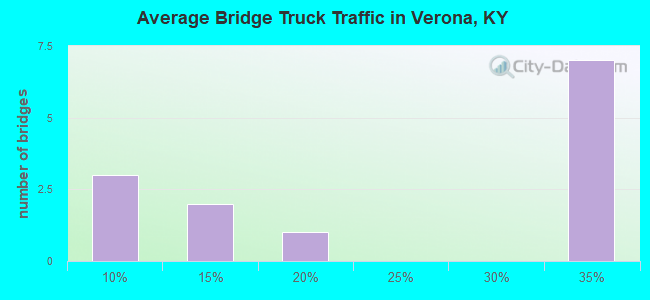
- 78,066Total average daily truck traffic
- National Bridge Inventory (NBI) Registered Bridges for Verona
- No street view available for this location
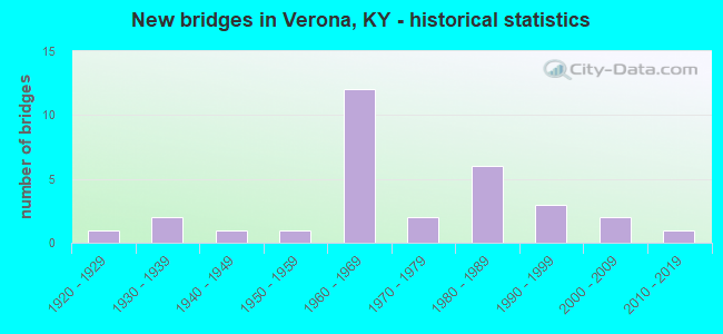
- New bridges - historical statistics
- 11920-1929
- 21930-1939
- 11940-1949
- 11950-1959
- 121960-1969
- 21970-1979
- 61980-1989
- 31990-1999
- 22000-2009
- 12010-2019
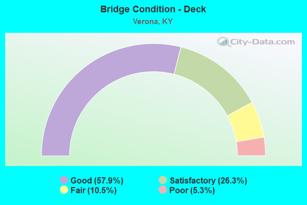
- Bridge Condition - Deck
- 57.9%Good
- 26.3%Satisfactory
- 10.5%Fair
- 5.3%Poor
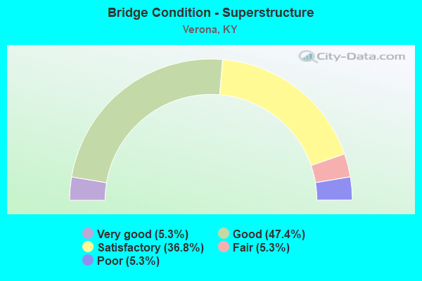
- Bridge Condition - Superstructure
- 5.3%Very good
- 47.4%Good
- 36.8%Satisfactory
- 5.3%Fair
- 5.3%Poor
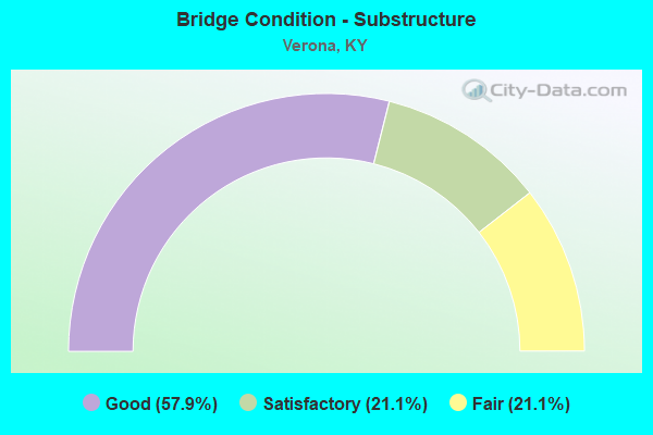
- Bridge Condition - Substructure
- 57.9%Good
- 21.1%Satisfactory
- 21.1%Fair
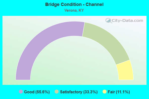
- Bridge Condition - Channel
- 55.6%Good
- 33.3%Satisfactory
- 11.1%Fair
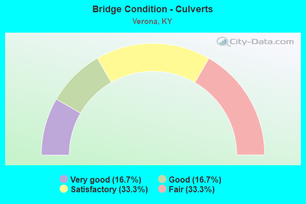
- Bridge Condition - Culverts
- 16.7%Very good
- 16.7%Good
- 33.3%Satisfactory
- 33.3%Fair
Find on map >> Show street view
Structure Number: 8B00004N, Location: 1.6 MI N.E. OF JCT KY 491 (Lat: 38.835278, Lng: -84.643056), Route carried "on" structure: State highway 14, Year Built: 1931, Status: Posted for load, Structure Length: 1.01m (3.31ft), Average Daily Traffic: 2,232 (year 2018), Truck Traffic: 12%, Average Future Daily Traffic: 1,964 (year 2038), Design Load: H 15, Features Intersected: LITTLE SALEM CREEK
Minimum Vertical Clearance: 30+ m (98+ ft), Kilometerpoint: 9.365, Lanes on structure: 2, Owner: State Highway Agency, Approaching Roadway Width: 5.5m (18.0ft), Skew: 4 degrees, Material/Design: Concrete, Design/Construction: Culvert, Number Of Spans In Main Unit: 2, Length of Maximum Span: 4.3m (14.1ft)
Condition: Channel: Fair, Culverts: Fair, Operating Rating: 22.7 metric tons, Method Used To Determine Operating Rating: Field evaluation and documented engineering judgment, Inventory Rating: 13.6 metric tons, Method Used To Determine Inventory Rating: Field evaluation and documented engineering judgment, Structural Evaluation: Meets minimum limits, Waterway Adequacy: Meets minimum limits, Approach Roadway Alignment: Equal to present minimum criteria, Bridge Posting: Required (Relationship of Operating Rating to Maximum Legal Load: > 39.9% below), Designated Inspection Frequency: Every 24 months, Inspection Date: June 2021
Find on map >> Show street view
Structure Number: 8B00031N, Location: 1.9 MI NW-VERONA-KY 16 (Lat: 38.832222, Lng: -84.687222), Route carried "on" structure: State highway 14, Year Built: 1967, Status: Open, Structure Length: 8.14m (26.71ft), Average Daily Traffic: 3,731 (year 2018), Truck Traffic: 14%, Average Future Daily Traffic: 3,283 (year 2038), Design Load: HS 20, Features Intersected: I-71
Minimum Vertical Clearance: 30+ m (98+ ft), Kilometerpoint: 3.549, Lanes on structure: 2, Lanes under structure: 4, Owner: State Highway Agency, Approaching Roadway Width: 11.0m (36.1ft), Skew: 22 degrees, Material/Design: Concrete continuous, Design/Construction: Tee Beam, Number Of Spans In Main Unit: 4, Length of Maximum Span: 22.9m (75.1ft), Curb or Sidewalk Widths: Left: 0.5m (1.6ft), Right: 0.5m (1.6ft), Curb-To-Curb Width: 9.1m (29.9ft), Out-to-Out Width: 10.9m (35.8ft)
Condition: Deck: Fair, Superstructure: Satisfactory, Substructure: Satisfactory, Operating Rating: 53.3 metric tons, Method Used To Determine Operating Rating: Load Factor (LF), Inventory Rating: 32.0 metric tons, Method Used To Determine Inventory Rating: Load Factor (LF), Structural Evaluation: Equal to present minimum criteria, Deck Geometry: Meets minimum limits, Underclear: Equal to present minimum criteria, Approach Roadway Alignment: Equal to present minimum criteria, Designated Inspection Frequency: Every 24 months, Inspection Date: June 2021, Deck Structure Type: Concrete Cast-file-Place, Wearing Surface/Protective System: Wearing Surface: Low Slump Concrete
Find on map >> Show street view
Structure Number: 8B00043N, Location: 1.5 MI N.E. OF KY 14 NTRC (Lat: 38.848333, Lng: -84.667222), Route carried "on" structure: Interstate 71, Year Built: 1967, Status: Open, Structure Length: 1.04m (3.41ft), Average Daily Traffic: 43,403 (year 2020), Truck Traffic: 30%, Average Future Daily Traffic: 52,951 (year 2040), Design Load: HS 20, Features Intersected: MCCOYS FORK
Minimum Vertical Clearance: 30+ m (98+ ft), Kilometerpoint: 118.507, Lanes on structure: 4, Base Highway Network: Yes, Owner: State Highway Agency, Approaching Roadway Width: 23.2m (76.1ft), Skew: 20 degrees, Material/Design: Concrete, Design/Construction: Culvert, Number Of Spans In Main Unit: 1, Length of Maximum Span: 9.1m (29.9ft)
Condition: Channel: Satisfactory, Culverts: Satisfactory, Operating Rating: 89.8 metric tons, Method Used To Determine Operating Rating: Load Factor (LF), Inventory Rating: 89.8 metric tons, Method Used To Determine Inventory Rating: Load Factor (LF), Structural Evaluation: Equal to present minimum criteria, Waterway Adequacy: Equal to present minimum criteria, Approach Roadway Alignment: Equal to present minimum criteria, Designated Inspection Frequency: Every 24 months, Inspection Date: June 2021
Find on map >> Show street view
Structure Number: 8B00047N, Location: .70 MI EAST OF JCT US 42 (Lat: 38.880278, Lng: -84.684722), Route carried "on" structure: State highway 1292, Year Built: 1952, Status: Open, Structure Length: 1.46m (4.79ft), Average Daily Traffic: 615 (year 2015), Average Future Daily Traffic: 541 (year 2035), Features Intersected: BEAVER BRANCH
Minimum Vertical Clearance: 30+ m (98+ ft), Kilometerpoint: 1.244, Lanes on structure: 2, Owner: State Highway Agency, Approaching Roadway Width: 5.5m (18.0ft), Material/Design: Steel, Design/Construction: Culvert, Number Of Spans In Main Unit: 2, Length of Maximum Span: 7.6m (24.9ft)
Condition: Channel: Satisfactory, Culverts: Fair, Operating Rating: 79.7 metric tons, Method Used To Determine Operating Rating: Load and Resistance Factor Rating (LRFR) rating reported by rating factor(RF) method using HL-93 loadings, Inventory Rating: 61.6 metric tons, Method Used To Determine Inventory Rating: Load and Resistance Factor Rating (LRFR) rating reported by rating factor(RF) method using HL-93 loadings, Structural Evaluation: Somewhat better than minimum adequacy, Waterway Adequacy: Better than present minimum criteria, Approach Roadway Alignment: Equal to present minimum criteria, Designated Inspection Frequency: Every 24 months, Inspection Date: June 2021
Find on map >> Show street view
Structure Number: 8B00064N, Location: 200 FT NOR. JCT KY 14 (Lat: 38.845000, Lng: -84.720833), Route carried "on" structure: US 42, Year Built: 1982, Status: Open, Structure Length: 6.31m (20.70ft), Average Daily Traffic: 3,994 (year 2018), Truck Traffic: 8%, Average Future Daily Traffic: 3,514 (year 2038), Design Load: HS 20, Features Intersected: MUD LICK CREEK
Minimum Vertical Clearance: 30+ m (98+ ft), Kilometerpoint: 3.631, Lanes on structure: 2, Owner: State Highway Agency, Approaching Roadway Width: 6.1m (20.0ft), Material/Design: Prestressed concrete continuous, Design/Construction: Stringer/Multi-beam, Number Of Spans In Main Unit: 3, Length of Maximum Span: 24.4m (80.1ft), Curb or Sidewalk Widths: Left: 0.5m (1.6ft), Right: 0.5m (1.6ft), Curb-To-Curb Width: 12.2m (40.0ft), Out-to-Out Width: 13.2m (43.3ft)
Condition: Deck: Good, Superstructure: Good, Substructure: Good, Channel: Good, Operating Rating: 68.8 metric tons, Method Used To Determine Operating Rating: Load Factor (LF), Inventory Rating: 41.3 metric tons, Method Used To Determine Inventory Rating: Load Factor (LF), Structural Evaluation: Better than present minimum criteria, Deck Geometry: Equal to present minimum criteria, Waterway Adequacy: Equal to present desirable criteria, Approach Roadway Alignment: Better than present minimum criteria, Designated Inspection Frequency: Every 24 months, Inspection Date: June 2021, Deck Structure Type: Concrete Cast-file-Place, Wearing Surface/Protective System: Wearing Surface: Monolithic Concrete, Deck Protection: Epoxy Coated Reinforcing
Find on map >> Show street view
Structure Number: 8B00067N, Location: .3 MI NE OF GALLATIN CL (Lat: 38.830556, Lng: -84.743333), Route carried "on" structure: US 42, Year Built: 1986, Status: Open, Structure Length: 1.98m (6.50ft), Average Daily Traffic: 4,355 (year 2018), Truck Traffic: 8%, Average Future Daily Traffic: 3,832 (year 2038), Design Load: HS 20, Features Intersected: LITTLE SOUTH FORK
Minimum Vertical Clearance: 30+ m (98+ ft), Kilometerpoint: 0.594, Lanes on structure: 2, Owner: State Highway Agency, Approaching Roadway Width: 7.3m (24.0ft), Skew: 1 degrees, Material/Design: Prestressed concrete, Design/Construction: Stringer/Multi-beam, Number Of Spans In Main Unit: 1, Length of Maximum Span: 18.3m (60.0ft), Curb or Sidewalk Widths: Left: 0.3m (1.0ft), Right: 0.3m (1.0ft), Curb-To-Curb Width: 8.5m (27.9ft), Out-to-Out Width: 9.5m (31.2ft)
Condition: Deck: Good, Superstructure: Good, Substructure: Good, Channel: Good, Operating Rating: 82.5 metric tons, Method Used To Determine Operating Rating: Load Factor (LF), Inventory Rating: 49.4 metric tons, Method Used To Determine Inventory Rating: Load Factor (LF), Structural Evaluation: Better than present minimum criteria, Deck Geometry: Meets minimum limits, Waterway Adequacy: Equal to present minimum criteria, Approach Roadway Alignment: Equal to present minimum criteria, Designated Inspection Frequency: Every 24 months, Inspection Date: June 2021, Deck Structure Type: Concrete Cast-file-Place, Wearing Surface/Protective System: Wearing Surface: Monolithic Concrete, Deck Protection: Epoxy Coated Reinforcing
Find on map >> Show street view
Structure Number: 8B00068N, Location: 2.5 MI S OF VERONA (Lat: 38.794722, Lng: -84.688333), Route carried "on" structure: State highway 16, Year Built: 1986, Status: Open, Structure Length: 2.77m (9.09ft), Average Daily Traffic: 2,020 (year 2020), Average Future Daily Traffic: 1,777 (year 2040), Design Load: HS 25 or greater, Features Intersected: CSX RAILROAD
Minimum Vertical Clearance: 30+ m (98+ ft), Kilometerpoint: 0.074, Lanes on structure: 2, Owner: State Highway Agency, Approaching Roadway Width: 7.3m (24.0ft), Material/Design: Prestressed concrete, Design/Construction: Stringer/Multi-beam, Number Of Spans In Main Unit: 1, Length of Maximum Span: 26.2m (86.0ft), Curb-To-Curb Width: 9.1m (29.9ft), Out-to-Out Width: 10.1m (33.1ft)
Condition: Deck: Good, Superstructure: Satisfactory, Substructure: Good, Operating Rating: 87.6 metric tons, Method Used To Determine Operating Rating: Load Factor (LF), Inventory Rating: 52.6 metric tons, Method Used To Determine Inventory Rating: Load Factor (LF), Structural Evaluation: Equal to present minimum criteria, Deck Geometry: Meets minimum limits, Underclear: Superior to present desirable criteria, Approach Roadway Alignment: Equal to present minimum criteria, Length Of Structure Improvement: 0.18m (0.59ft), Designated Inspection Frequency: Every 24 months, Inspection Date: June 2021, Deck Structure Type: Concrete Cast-file-Place, Wearing Surface/Protective System: Wearing Surface: Monolithic Concrete, Deck Protection: Epoxy Coated Reinforcing
Find on map >> Show street view
Structure Number: 8C00012N, Location: 1.8 MI NW OF JCT KY 14/16 (Lat: 38.850833, Lng: -84.663056), Route carried "on" structure: County highway 1144, Year Built: 1940, Status: Posted for load, Structure Length: 1.43m (4.69ft), Average Daily Traffic: 219 (year 2009), Average Future Daily Traffic: 190 (year 2029), Features Intersected: MCCOYS FORK, Facility Carried by Structure: STEPHENSON MILL RD
Minimum Vertical Clearance: 30+ m (98+ ft), Kilometerpoint: 3.998, Lanes on structure: 1, Owner: County Highway Agency, Approaching Roadway Width: 5.5m (18.0ft), Material/Design: Steel, Design/Construction: Culvert, Number Of Spans In Main Unit: 2, Length of Maximum Span: 6.7m (22.0ft)
Condition: Channel: Satisfactory, Culverts: Satisfactory, Operating Rating: 97.2 metric tons, Method Used To Determine Operating Rating: Load and Resistance Factor Rating (LRFR) rating reported by rating factor(RF) method using HL-93 loadings, Inventory Rating: 85.2 metric tons, Method Used To Determine Inventory Rating: Load and Resistance Factor Rating (LRFR) rating reported by rating factor(RF) method using HL-93 loadings, Structural Evaluation: Equal to present minimum criteria, Waterway Adequacy: Better than present minimum criteria, Approach Roadway Alignment: High priority of corrective action, Designated Inspection Frequency: Every 24 months, Inspection Date: September 2020
Find on map >> Show street view
Structure Number: 8C00051N, Location: 1.1 MI SW - KY 14 (Lat: 38.821111, Lng: -84.706389), Route carried "on" structure: County highway 1207, Year Built: 1992, Status: Posted for load, Structure Length: 0.85m (2.79ft), Average Daily Traffic: 506 (year 2009), Average Future Daily Traffic: 440 (year 2029), Design Load: HS 25 or greater, Features Intersected: LITTLE SOUTH FORK, Facility Carried by Structure: BROWN RD
Minimum Vertical Clearance: 30+ m (98+ ft), Kilometerpoint: 2.036, Lanes on structure: 2, Owner: County Highway Agency, Approaching Roadway Width: 6.1m (20.0ft), Skew: 1 degrees, Material/Design: Prestressed concrete, Design/Construction: Box Beam or Girders - Multiple, Number Of Spans In Main Unit: 1, Length of Maximum Span: 7.9m (25.9ft), Curb or Sidewalk Widths: Left: 0.2m (0.7ft), Right: 0.2m (0.7ft), Curb-To-Curb Width: 6.9m (22.6ft), Out-to-Out Width: 7.3m (24.0ft)
Condition: Deck: Good, Superstructure: Good, Substructure: Good, Channel: Good, Operating Rating: 48.5 metric tons, Method Used To Determine Operating Rating: Load Factor (LF), Inventory Rating: 29.1 metric tons, Method Used To Determine Inventory Rating: Load Factor (LF), Structural Evaluation: Better than present minimum criteria, Deck Geometry: Meets minimum limits, Waterway Adequacy: Equal to present desirable criteria, Approach Roadway Alignment: Better than present minimum criteria, Bridge Posting: Required (Relationship of Operating Rating to Maximum Legal Load: 20.0 - 29.9% below), Designated Inspection Frequency: Every 24 months, Inspection Date: September 2020, Deck Structure Type: Concrete Precast Panels, Wearing Surface/Protective System: Wearing Surface: Bituminous
Find on map >> Show street view
Structure Number: 39B00006N, Location: 2.3 MI EAST OF JCT KY 562 (Lat: 38.781667, Lng: -84.727500), Route carried "on" structure: State highway 16, Year Built: 1934, Status: Posted for load, Structure Length: 1.13m (3.71ft), Average Daily Traffic: 1,217 (year 2019), Average Future Daily Traffic: 1,070 (year 2039), Design Load: H 15, Features Intersected: BIG SOUTH FORK
Minimum Vertical Clearance: 30+ m (98+ ft), Kilometerpoint: 13.671, Lanes on structure: 2, Owner: State Highway Agency, Approaching Roadway Width: 5.5m (18.0ft), Material/Design: Concrete, Design/Construction: Tee Beam, Number Of Spans In Main Unit: 1, Length of Maximum Span: 10.4m (34.1ft), Curb or Sidewalk Widths: Left: 0.5m (1.6ft), Right: 0.5m (1.6ft), Curb-To-Curb Width: 6.9m (22.6ft), Out-to-Out Width: 6.9m (22.6ft)
Condition: Deck: Good, Superstructure: Satisfactory, Substructure: Fair, Channel: Satisfactory, Operating Rating: 52.3 metric tons, Method Used To Determine Operating Rating: Load Factor (LF), Inventory Rating: 31.4 metric tons, Method Used To Determine Inventory Rating: Load Factor (LF), Structural Evaluation: Somewhat better than minimum adequacy, Deck Geometry: High priority of corrective action, Waterway Adequacy: Better than present minimum criteria, Approach Roadway Alignment: Equal to present minimum criteria, Bridge Posting: Required (Relationship of Operating Rating to Maximum Legal Load: 20.0 - 29.9% below), Designated Inspection Frequency: Every 24 months, Inspection Date: July 2021, Deck Structure Type: Concrete Cast-file-Place, Wearing Surface/Protective System: Wearing Surface: Bituminous
Find on map >> Show street view
Structure Number: 39B00027L, Location: SBL 2.5 MI SW-BOONE CO.LN (Lat: 38.783333, Lng: -84.752222), Route carried "on" structure: Interstate 71, Year Built: 1967, Status: Open, Structure Length: 3.90m (12.80ft), Average Daily Traffic: 15,454 (year 2020), Truck Traffic: 33%, Average Future Daily Traffic: 18,854 (year 2040), Design Load: HS 20, Features Intersected: ROBERTS ROAD
Minimum Vertical Clearance: 30+ m (98+ ft), Kilometerpoint: 108.093, Lanes on structure: 2, Lanes under structure: 2, Base Highway Network: Yes, Owner: State Highway Agency, Approaching Roadway Width: 11.6m (38.1ft), Skew: 1 degrees, Material/Design: Concrete, Design/Construction: Tee Beam, Number Of Spans In Main Unit: 3, Length of Maximum Span: 13.1m (43.0ft), Curb or Sidewalk Widths: Left: 0.3m (1.0ft), Right: 0.3m (1.0ft), Curb-To-Curb Width: 11.6m (38.1ft), Out-to-Out Width: 12.7m (41.7ft)
Condition: Deck: Fair, Superstructure: Fair, Substructure: Fair, Operating Rating: 66.9 metric tons, Method Used To Determine Operating Rating: Load Factor (LF), Inventory Rating: 40.1 metric tons, Method Used To Determine Inventory Rating: Load Factor (LF), Structural Evaluation: Somewhat better than minimum adequacy, Deck Geometry: Equal to present minimum criteria, Underclear: Meets minimum limits, Approach Roadway Alignment: Superior to present desirable criteria, Length Of Structure Improvement: 0.39m (1.28ft), Designated Inspection Frequency: Every 24 months, Inspection Date: July 2021, Bridge Improvement Cost: $666,000, Total Project Cost: $665,000, Deck Structure Type: Concrete Cast-file-Place, Wearing Surface/Protective System: Wearing Surface: Latex Concrete
Find on map >> Show street view
Structure Number: 39B00027R, Location: NBL 2.5 MI SW-BOONE CO.LN (Lat: 38.783056, Lng: -84.752222), Route carried "on" structure: Interstate 71, Year Built: 1967, Status: Open, Structure Length: 3.90m (12.80ft), Average Daily Traffic: 15,454 (year 2020), Truck Traffic: 33%, Average Future Daily Traffic: 18,854 (year 2040), Design Load: HS 20, Features Intersected: ROBERTS ROAD
Minimum Vertical Clearance: 30+ m (98+ ft), Kilometerpoint: 108.059, Lanes on structure: 2, Lanes under structure: 2, Base Highway Network: Yes, Owner: State Highway Agency, Approaching Roadway Width: 11.6m (38.1ft), Skew: 1 degrees, Material/Design: Concrete, Design/Construction: Tee Beam, Number Of Spans In Main Unit: 3, Length of Maximum Span: 13.1m (43.0ft), Curb or Sidewalk Widths: Left: 0.3m (1.0ft), Right: 0.3m (1.0ft), Curb-To-Curb Width: 11.6m (38.1ft), Out-to-Out Width: 12.7m (41.7ft)
Condition: Deck: Satisfactory, Superstructure: Satisfactory, Substructure: Fair, Operating Rating: 66.9 metric tons, Method Used To Determine Operating Rating: Load Factor (LF), Inventory Rating: 40.1 metric tons, Method Used To Determine Inventory Rating: Load Factor (LF), Structural Evaluation: Somewhat better than minimum adequacy, Deck Geometry: Equal to present minimum criteria, Underclear: Meets minimum limits, Approach Roadway Alignment: Superior to present desirable criteria, Length Of Structure Improvement: 0.39m (1.28ft), Designated Inspection Frequency: Every 24 months, Inspection Date: July 2021, Bridge Improvement Cost: $666,000, Total Project Cost: $665,000, Deck Structure Type: Concrete Cast-file-Place, Wearing Surface/Protective System: Wearing Surface: Latex Concrete
Find on map >> Show street view
Structure Number: 39B00028N, Location: .60 MI S.W. OF BOONE CL (Lat: 38.805278, Lng: -84.726111), Route carried "on" structure: Interstate 71, Year Built: 1967, Status: Open, Structure Length: 0.88m (2.89ft), Average Daily Traffic: 30,908 (year 2020), Truck Traffic: 33%, Average Future Daily Traffic: 37,707 (year 2040), Design Load: HS 20, Features Intersected: BIG SOUTH FORK CREEK
Minimum Vertical Clearance: 30+ m (98+ ft), Kilometerpoint: 111.425, Lanes on structure: 4, Base Highway Network: Yes, Owner: State Highway Agency, Approaching Roadway Width: 11.6m (38.1ft), Skew: 21 degrees, Material/Design: Concrete, Design/Construction: Culvert, Number Of Spans In Main Unit: 1, Length of Maximum Span: 8.8m (28.9ft)
Condition: Channel: Satisfactory, Culverts: Good, Operating Rating: 99.8 metric tons, Method Used To Determine Operating Rating: Field evaluation and documented engineering judgment, Inventory Rating: 99.8 metric tons, Method Used To Determine Inventory Rating: Field evaluation and documented engineering judgment, Structural Evaluation: Better than present minimum criteria, Waterway Adequacy: Equal to present desirable criteria, Approach Roadway Alignment: Superior to present desirable criteria, Designated Inspection Frequency: Every 24 months, Inspection Date: July 2021
Find on map >> Show street view
Structure Number: 39B00029N, Location: .9 MI NW OF JCT KY 2850 (Lat: 38.797778, Lng: -84.733889), Route carried "on" structure: County highway 1004, Year Built: 1967, Status: Posted for load, Structure Length: 7.47m (24.51ft), Average Daily Traffic: 141 (year 2009), Average Future Daily Traffic: 122 (year 2029), Design Load: H 20, Features Intersected: I-71, Facility Carried by Structure: WALNUT LICK RD
Minimum Vertical Clearance: 30+ m (98+ ft), Kilometerpoint: 1.659, Lanes on structure: 2, Lanes under structure: 4, Owner: State Highway Agency, Approaching Roadway Width: 5.5m (18.0ft), Skew: 20 degrees, Material/Design: Concrete continuous, Design/Construction: Tee Beam, Number Of Spans In Main Unit: 4, Length of Maximum Span: 21.3m (69.9ft), Curb or Sidewalk Widths: Left: 0.5m (1.6ft), Right: 0.5m (1.6ft), Curb-To-Curb Width: 7.9m (25.9ft), Out-to-Out Width: 9.7m (31.8ft)
Condition: Deck: Satisfactory, Superstructure: Good, Substructure: Good, Operating Rating: 40.9 metric tons, Method Used To Determine Operating Rating: Load Factor (LF), Inventory Rating: 24.5 metric tons, Method Used To Determine Inventory Rating: Load Factor (LF), Structural Evaluation: Equal to present minimum criteria, Deck Geometry: Somewhat better than minimum adequacy, Underclear: Somewhat better than minimum adequacy, Approach Roadway Alignment: Equal to present minimum criteria, Bridge Posting: Required (Relationship of Operating Rating to Maximum Legal Load: 10.0 - 19.9% below), Designated Inspection Frequency: Every 24 months, Inspection Date: July 2021, Deck Structure Type: Concrete Cast-file-Place, Wearing Surface/Protective System: Wearing Surface: Low Slump Concrete, Deck Protection: Epoxy Coated Reinforcing
Find on map >> Show street view
Structure Number: 39B00030N, Location: .10 MI S.W. OF BOONE CL (Lat: 38.810000, Lng: -84.717500), Route carried "on" structure: State highway 2850, Year Built: 1967, Status: Posted for load, Structure Length: 8.35m (27.40ft), Average Daily Traffic: 376 (year 2020), Average Future Daily Traffic: 327 (year 2040), Design Load: H 20, Features Intersected: I-71
Minimum Vertical Clearance: 30+ m (98+ ft), Kilometerpoint: 3.420, Lanes on structure: 2, Lanes under structure: 4, Owner: State Highway Agency, Approaching Roadway Width: 5.5m (18.0ft), Skew: 20 degrees, Material/Design: Concrete continuous, Design/Construction: Tee Beam, Number Of Spans In Main Unit: 4, Length of Maximum Span: 24.1m (79.1ft), Curb or Sidewalk Widths: Left: 0.6m (2.0ft), Right: 0.6m (2.0ft), Curb-To-Curb Width: 7.9m (25.9ft), Out-to-Out Width: 10.1m (33.1ft)
Condition: Deck: Good, Superstructure: Satisfactory, Substructure: Good, Operating Rating: 45.7 metric tons, Method Used To Determine Operating Rating: Load Factor (LF), Inventory Rating: 27.5 metric tons, Method Used To Determine Inventory Rating: Load Factor (LF), Structural Evaluation: Equal to present minimum criteria, Deck Geometry: Somewhat better than minimum adequacy, Underclear: Somewhat better than minimum adequacy, Approach Roadway Alignment: Equal to present minimum criteria, Bridge Posting: Required (Relationship of Operating Rating to Maximum Legal Load: 10.0 - 19.9% below), Designated Inspection Frequency: Every 24 months, Inspection Date: July 2021, Deck Structure Type: Concrete Cast-file-Place, Wearing Surface/Protective System: Wearing Surface: Monolithic Concrete, Deck Protection: Epoxy Coated Reinforcing
Find on map >> Show street view
Structure Number: 39B00033N, Location: .35 MI S.W. OF BOONE CL (Lat: 38.826667, Lng: -84.753056), Route carried "on" structure: US 42, Year Built: 1980, Status: Open, Structure Length: 2.65m (8.69ft), Average Daily Traffic: 4,355 (year 2018), Truck Traffic: 8%, Average Future Daily Traffic: 3,832 (year 2038), Design Load: HS 20, Features Intersected: BIG SOUTH FORK
Minimum Vertical Clearance: 30+ m (98+ ft), Kilometerpoint: 26.821, Lanes on structure: 2, Owner: State Highway Agency, Approaching Roadway Width: 7.3m (24.0ft), Skew: 4 degrees, Material/Design: Prestressed concrete, Design/Construction: Stringer/Multi-beam, Number Of Spans In Main Unit: 1, Length of Maximum Span: 24.4m (80.1ft), Curb or Sidewalk Widths: Left: 0.2m (0.7ft), Right: 0.2m (0.7ft), Curb-To-Curb Width: 12.2m (40.0ft), Out-to-Out Width: 13.2m (43.3ft)
Condition: Deck: Good, Superstructure: Good, Substructure: Satisfactory, Channel: Good, Operating Rating: 76.7 metric tons, Method Used To Determine Operating Rating: Load Factor (LF), Inventory Rating: 46.0 metric tons, Method Used To Determine Inventory Rating: Load Factor (LF), Structural Evaluation: Equal to present minimum criteria, Deck Geometry: Equal to present minimum criteria, Waterway Adequacy: Equal to present minimum criteria, Approach Roadway Alignment: Better than present minimum criteria, Designated Inspection Frequency: Every 24 months, Inspection Date: July 2021, Deck Structure Type: Concrete Cast-file-Place, Wearing Surface/Protective System: Wearing Surface: Monolithic Concrete, Deck Protection: Epoxy Coated Reinforcing
Find on map >> Show street view
Structure Number: 39C00005N, Location: 1 MI NW OF JCT KY 16 (Lat: 38.796389, Lng: -84.717500), Route carried "on" structure: County highway 1004, Year Built: 1925, Year Reconstructed: 1972, Status: Open, Structure Length: 1.22m (4.00ft), Average Daily Traffic: 198 (year 2009), Average Future Daily Traffic: 172 (year 2029), Features Intersected: BIG SOUTH FORK, Facility Carried by Structure: WALNUT LICK RD
Minimum Vertical Clearance: 30+ m (98+ ft), Kilometerpoint: 0.040, Lanes on structure: 1, Owner: County Highway Agency, Approaching Roadway Width: 3.7m (12.1ft), Material/Design: Prestressed concrete, Design/Construction: Box Beam or Girders - Multiple, Number Of Spans In Main Unit: 1, Length of Maximum Span: 10.4m (34.1ft), Curb-To-Curb Width: 4.6m (15.1ft), Out-to-Out Width: 4.6m (15.1ft)
Condition: Deck: Satisfactory, Superstructure: Good, Substructure: Good, Channel: Fair, Operating Rating: 65.8 metric tons, Method Used To Determine Operating Rating: Load Factor (LF), Inventory Rating: 39.5 metric tons, Method Used To Determine Inventory Rating: Load Factor (LF), Structural Evaluation: Better than present minimum criteria, Deck Geometry: High priority of replacement, Waterway Adequacy: Better than present minimum criteria, Approach Roadway Alignment: High priority of corrective action, Length Of Structure Improvement: 0.11m (0.36ft), Designated Inspection Frequency: Every 24 months, Inspection Date: April 2021, Bridge Improvement Cost: $66,000, Total Project Cost: $66,000, Deck Structure Type: Concrete Precast Panels, Wearing Surface/Protective System: Wearing Surface: Monolithic Concrete
Find on map >> Show street view
Structure Number: 39C00016N, Location: .1 MI S JCT CR 5211 (Lat: 38.831389, Lng: -84.750833), Route carried "on" structure: County highway 1009, Year Built: 2007, Status: Open, Structure Length: 1.10m (3.61ft), Average Daily Traffic: 16 (year 2011), Average Future Daily Traffic: 28 (year 2031), Features Intersected: BIG SOUTH FORK
Minimum Vertical Clearance: 30+ m (98+ ft), Kilometerpoint: 1.690, Lanes on structure: 1, Owner: County Highway Agency, Approaching Roadway Width: 6.8m (22.3ft), Material/Design: Concrete, Design/Construction: Culvert, Number Of Spans In Main Unit: 1, Length of Maximum Span: 11.0m (36.1ft)
Condition: Channel: Good, Culverts: Very good, Operating Rating: 54.4 metric tons, Method Used To Determine Operating Rating: Field evaluation and documented engineering judgment, Inventory Rating: 39.9 metric tons, Method Used To Determine Inventory Rating: Field evaluation and documented engineering judgment, Structural Evaluation: Equal to present desirable criteria, Waterway Adequacy: Equal to present desirable criteria, Approach Roadway Alignment: Equal to present desirable criteria, Designated Inspection Frequency: Every 24 months, Inspection Date: April 2021
Find on map >> Show street view
Structure Number: 39C00017N, Location: .5 MI E OF CONCORD RD (Lat: 38.773889, Lng: -84.694444), Route carried "on" structure: County highway 1006, Year Built: 2010, Status: Open, Structure Length: 1.08m (3.54ft), Average Daily Traffic: 50 (year 2012), Average Future Daily Traffic: 55 (year 2032), Features Intersected: BRANCH OF BIG SOUTH FORK, Facility Carried by Structure: MUNK SPUR ROAD
Minimum Vertical Clearance: 30+ m (98+ ft), Kilometerpoint: 0.806, Lanes on structure: 1, Owner: County Highway Agency, Approaching Roadway Width: 3.7m (12.1ft), Material/Design: Steel, Design/Construction: Stringer/Multi-beam, Number Of Spans In Main Unit: 1, Length of Maximum Span: 9.8m (32.2ft), Curb-To-Curb Width: 3.7m (12.1ft), Out-to-Out Width: 3.7m (12.1ft)
Condition: Deck: Satisfactory, Superstructure: Satisfactory, Substructure: Good, Channel: Good, Operating Rating: 59.2 metric tons, Method Used To Determine Operating Rating: Load Factor (LF), Inventory Rating: 35.6 metric tons, Method Used To Determine Inventory Rating: Load Factor (LF), Structural Evaluation: Equal to present minimum criteria, Deck Geometry: Meets minimum limits, Waterway Adequacy: Meets minimum limits, Approach Roadway Alignment: High priority of corrective action, Designated Inspection Frequency: Every 24 months, Inspection Date: April 2021, Deck Structure Type: Open Grating, Wearing Surface/Protective System: Wearing Surface: Other
Find on map >> Show street view
Structure Number: 39C00018N, Location: 1.6 MI N OF JCT US 42 (Lat: 38.846111, Lng: -84.759722), Route carried "on" structure: County highway 1011, Year Built: 1985, Status: Open, Structure Length: 1.22m (4.00ft), Average Daily Traffic: 16 (year 2012), Average Future Daily Traffic: 28 (year 2032), Design Load: HS 20, Features Intersected: BIG SOUTH FORK CREEK, Facility Carried by Structure: CR-1211
Minimum Vertical Clearance: 30+ m (98+ ft), Kilometerpoint: 0.002, Lanes on structure: 2, Owner: County Highway Agency, Approaching Roadway Width: 4.9m (16.1ft), Material/Design: Prestressed concrete, Design/Construction: Box Beam or Girders - Multiple, Number Of Spans In Main Unit: 1, Length of Maximum Span: 11.6m (38.1ft), Curb-To-Curb Width: 5.9m (19.4ft), Out-to-Out Width: 6.1m (20.0ft)
Condition: Deck: Poor, Superstructure: Good, Substructure: Satisfactory, Channel: Good, Operating Rating: 60.9 metric tons, Method Used To Determine Operating Rating: Load Factor (LF), Inventory Rating: 36.6 metric tons, Method Used To Determine Inventory Rating: Load Factor (LF), Structural Evaluation: Equal to present minimum criteria, Deck Geometry: Meets minimum limits, Waterway Adequacy: Equal to present desirable criteria, Approach Roadway Alignment: Somewhat better than minimum adequacy, Designated Inspection Frequency: Every 24 months, Inspection Date: April 2021, Deck Structure Type: Concrete Precast Panels, Wearing Surface/Protective System: Wearing Surface: Bituminous
Find on map >> Show street view
Structure Number: 41B00001N, Location: .6 MI S OF GALLATIN C.L. (Lat: 38.768333, Lng: -84.667778), Route carried "on" structure: State highway 1942, Year Built: 1974, Status: Posted for load, Structure Length: 1.80m (5.91ft), Average Daily Traffic: 184 (year 2018), Average Future Daily Traffic: 161 (year 2038), Design Load: H 20, Features Intersected: TEN MILE CREEK
Minimum Vertical Clearance: 30+ m (98+ ft), Kilometerpoint: 17.473, Lanes on structure: 2, Owner: State Highway Agency, Approaching Roadway Width: 4.3m (14.1ft), Material/Design: Prestressed concrete, Design/Construction: Box Beam or Girders - Multiple, Number Of Spans In Main Unit: 1, Length of Maximum Span: 17.1m (56.1ft), Curb or Sidewalk Widths: Left: 0.3m (1.0ft), Right: 0.3m (1.0ft), Curb-To-Curb Width: 5.9m (19.4ft), Out-to-Out Width: 6.6m (21.7ft)
Condition: Deck: Good, Superstructure: Satisfactory, Substructure: Fair, Channel: Good, Operating Rating: 23.6 metric tons, Method Used To Determine Operating Rating: Load Factor (LF), Inventory Rating: 14.2 metric tons, Method Used To Determine Inventory Rating: Load Factor (LF), Structural Evaluation: Meets minimum limits, Deck Geometry: High priority of corrective action, Waterway Adequacy: Equal to present desirable criteria, Approach Roadway Alignment: Somewhat better than minimum adequacy, Bridge Posting: Required (Relationship of Operating Rating to Maximum Legal Load: > 39.9% below), Length Of Structure Improvement: 0.18m (0.59ft), Designated Inspection Frequency: Every 24 months, Inspection Date: July 2020, Bridge Improvement Cost: $155,000, Total Project Cost: $154,000, Deck Structure Type: Concrete Precast Panels, Wearing Surface/Protective System: Wearing Surface: Bituminous, Membrane: Preformed Fabric
Find on map >> Show street view
Structure Number: 41B00017N, Location: ON BOONE - GRANT CL (Lat: 38.786111, Lng: -84.657500), Route carried "on" structure: State highway 491, Year Built: 1970, Status: Posted for load, Structure Length: 2.14m (7.02ft), Average Daily Traffic: 1,136 (year 2020), Average Future Daily Traffic: 999 (year 2040), Design Load: HS 20, Features Intersected: BULLOCK CREEK
Minimum Vertical Clearance: 30+ m (98+ ft), Kilometerpoint: 0.008, Lanes on structure: 2, Owner: State Highway Agency, Approaching Roadway Width: 5.8m (19.0ft), Material/Design: Prestressed concrete, Design/Construction: Box Beam or Girders - Multiple, Number Of Spans In Main Unit: 1, Length of Maximum Span: 20.4m (66.9ft), Curb or Sidewalk Widths: Left: 0.2m (0.7ft), Right: 0.2m (0.7ft), Curb-To-Curb Width: 6.0m (19.7ft), Out-to-Out Width: 6.5m (21.3ft)
Condition: Deck: Satisfactory, Superstructure: Poor, Substructure: Satisfactory, Channel: Good, Operating Rating: 24.6 metric tons, Method Used To Determine Operating Rating: Load Factor (LF), Inventory Rating: 14.8 metric tons, Method Used To Determine Inventory Rating: Load Factor (LF), Structural Evaluation: Meets minimum limits, Deck Geometry: High priority of replacement, Waterway Adequacy: Equal to present desirable criteria, Approach Roadway Alignment: Equal to present minimum criteria, Bridge Posting: Required (Relationship of Operating Rating to Maximum Legal Load: > 39.9% below), Length Of Structure Improvement: 0.21m (0.69ft), Designated Inspection Frequency: Every 24 months, Inspection Date: July 2020, Bridge Improvement Cost: $184,000, Total Project Cost: $183,000, Deck Structure Type: Concrete Precast Panels, Wearing Surface/Protective System: Wearing Surface: Monolithic Concrete
Find on map >> Show street view
Structure Number: 41C00035N, Location: 5.6 MI NW JCT KY 1942 (Lat: 38.764722, Lng: -84.750000), Route carried "on" structure: County highway 1315, Year Built: 1986, Status: Open, Structure Length: 0.98m (3.22ft), Average Daily Traffic: 127 (year 2006), Average Future Daily Traffic: 196 (year 2026), Design Load: HS 20, Features Intersected: FLAT CREEK, Facility Carried by Structure: NAPOLEON-ZION STAT
Minimum Vertical Clearance: 30+ m (98+ ft), Kilometerpoint: 10.686, Lanes on structure: 2, Owner: County Highway Agency, Approaching Roadway Width: 3.7m (12.1ft), Skew: 4 degrees, Material/Design: Prestressed concrete, Design/Construction: Box Beam or Girders - Multiple, Number Of Spans In Main Unit: 1, Length of Maximum Span: 8.8m (28.9ft), Curb-To-Curb Width: 5.3m (17.4ft), Out-to-Out Width: 5.3m (17.4ft)
Condition: Deck: Good, Superstructure: Good, Substructure: Good, Channel: Satisfactory, Operating Rating: 70.5 metric tons, Method Used To Determine Operating Rating: Load Factor (LF), Inventory Rating: 42.3 metric tons, Method Used To Determine Inventory Rating: Load Factor (LF), Structural Evaluation: Better than present minimum criteria, Deck Geometry: High priority of replacement, Waterway Adequacy: Better than present minimum criteria, Approach Roadway Alignment: Equal to present minimum criteria, Designated Inspection Frequency: Every 24 months, Inspection Date: May 2021, Deck Structure Type: Concrete Precast Panels, Wearing Surface/Protective System: Wearing Surface: Monolithic Concrete
Find on map >> Show street view
Structure Number: 41C00040N, Location: 3.3 MI NW OF JCT KY 1942 (Lat: 38.752222, Lng: -84.708889), Route carried "on" structure: County highway 1315, Year Built: 2007, Status: Open, Structure Length: 10.45m (34.28ft), Design Load: HS 25 or greater, Features Intersected: TEN MILE CREEK, Facility Carried by Structure: NAPOLEON-ZION STAT
Minimum Vertical Clearance: 30+ m (98+ ft), Kilometerpoint: 5.180, Lanes on structure: 2, Owner: County Highway Agency, Approaching Roadway Width: 8.8m (28.9ft), Material/Design: Prestressed concrete continuous, Design/Construction: Stringer/Multi-beam, Number Of Spans In Main Unit: 3, Length of Maximum Span: 36.6m (120.1ft), Curb or Sidewalk Widths: Left: 0.5m (1.6ft), Right: 0.5m (1.6ft), Curb-To-Curb Width: 7.3m (24.0ft), Out-to-Out Width: 8.3m (27.2ft)
Condition: Deck: Good, Superstructure: Very good, Substructure: Good, Channel: Good, Operating Rating: 99.8 metric tons, Method Used To Determine Operating Rating: Load Factor (LF), Inventory Rating: 62.0 metric tons, Method Used To Determine Inventory Rating: Load Factor (LF), Structural Evaluation: Better than present minimum criteria, Deck Geometry: Equal to present minimum criteria, Waterway Adequacy: Better than present minimum criteria, Approach Roadway Alignment: Equal to present desirable criteria, Designated Inspection Frequency: Every 24 months, Inspection Date: May 2021, Deck Structure Type: Concrete Cast-file-Place, Wearing Surface/Protective System: Wearing Surface: Integral Concrete, Deck Protection: Epoxy Coated Reinforcing
Find on map >> Show street view
Structure Number: 59B00098N, Location: .2 MI.W JCT US 25 (Lat: 38.826944, Lng: -84.600000), Route carried "on" structure: County highway 1222, Year Built: 1998, Status: Open, Structure Length: 7.53m (24.70ft), Average Daily Traffic: 340 (year 2006), Average Future Daily Traffic: 2,026 (year 2026), Design Load: HS 25 or greater, Features Intersected: I-75 @ 168.676, Facility Carried by Structure: EADS RD
Minimum Vertical Clearance: 30+ m (98+ ft), Kilometerpoint: 1.156, Lanes on structure: 2, Lanes under structure: 6, Owner: State Highway Agency, Approaching Roadway Width: 5.5m (18.0ft), Skew: 12 degrees, Material/Design: Prestressed concrete continuous, Design/Construction: Stringer/Multi-beam, Number Of Spans In Main Unit: 4, Length of Maximum Span: 28.0m (91.9ft), Curb or Sidewalk Widths: Left: 0.5m (1.6ft), Right: 0.5m (1.6ft), Curb-To-Curb Width: 8.4m (27.6ft), Out-to-Out Width: 9.4m (30.8ft)
Condition: Deck: Good, Superstructure: Good, Substructure: Good, Operating Rating: 99.8 metric tons, Method Used To Determine Operating Rating: Load Factor (LF), Inventory Rating: 91.3 metric tons, Method Used To Determine Inventory Rating: Load Factor (LF), Structural Evaluation: Better than present minimum criteria, Deck Geometry: Somewhat better than minimum adequacy, Underclear: Somewhat better than minimum adequacy, Approach Roadway Alignment: Better than present minimum criteria, Designated Inspection Frequency: Every 24 months, Inspection Date: October 2021, Deck Structure Type: Concrete Cast-file-Place, Wearing Surface/Protective System: Wearing Surface: Monolithic Concrete, Deck Protection: Epoxy Coated Reinforcing
Find on map >> Show street view
Structure Number: 8B00031N, Location: 1.9 MI NW-VERONA-KY 16 (Lat: 38.832222, Lng: -84.687222), Route carried "under" structure: Interstate 71, Year Built: 1967, Structure Length: 0. m, Average Daily Traffic: 43,403 (year 2020), Truck Traffic: 30%, Features Intersected: I-71, Facility Carried by Structure: KY-14
Minimum Vertical Clearance: 5.69m (18.67ft), Kilometerpoint: 116.014, Lanes on structure: 2, Lanes under structure: 4, Material/Design: Concrete continuous, Design/Construction: Tee Beam, Length of Maximum Span: 22.9m (75.1ft)
Find on map >> Show street view
Structure Number: 39B00027L, Location: SBL 2.5 MI SW-BOONE CO.LN (Lat: 38.783333, Lng: -84.752222), Route carried "under" structure: County highway 1003, Year Built: 1967, Structure Length: 0. m, Average Daily Traffic: 127 (year 2006), Features Intersected: ROBERTS ROAD, Facility Carried by Structure: I-71
Minimum Vertical Clearance: 4.45m (14.60ft), Kilometerpoint: 0.233, Lanes on structure: 2, Lanes under structure: 2, Material/Design: Concrete, Design/Construction: Tee Beam, Length of Maximum Span: 13.1m (43.0ft)
Find on map >> Show street view
Structure Number: 39B00027R, Location: NBL 2.5 MI SW-BOONE CO.LN (Lat: 38.783056, Lng: -84.752222), Route carried "under" structure: County highway 1003, Year Built: 1967, Structure Length: 0. m, Average Daily Traffic: 127 (year 2006), Features Intersected: ROBERTS ROAD, Facility Carried by Structure: I-71
Minimum Vertical Clearance: 5.36m (17.59ft), Kilometerpoint: 0.203, Lanes on structure: 2, Lanes under structure: 2, Material/Design: Concrete, Design/Construction: Tee Beam, Length of Maximum Span: 13.1m (43.0ft)
Find on map >> Show street view
Structure Number: 39B00029N, Location: .9 MI NW OF JCT KY 2850 (Lat: 38.797778, Lng: -84.733889), Route carried "under" structure: Interstate 71, Year Built: 1967, Structure Length: 0. m, Average Daily Traffic: 30,908 (year 2020), Truck Traffic: 33%, Features Intersected: I-71, Facility Carried by Structure: WALNUT LICK RD
Minimum Vertical Clearance: 5.33m (17.49ft), Kilometerpoint: 110.353, Lanes on structure: 2, Lanes under structure: 4, Material/Design: Concrete continuous, Design/Construction: Tee Beam, Length of Maximum Span: 21.3m (69.9ft)
Find on map >> Show street view
Structure Number: 39B00030N, Location: .10 MI S.W. OF BOONE CL (Lat: 38.810000, Lng: -84.717500), Route carried "under" structure: Interstate 71, Year Built: 1967, Structure Length: 0. m, Average Daily Traffic: 30,908 (year 2020), Truck Traffic: 33%, Features Intersected: I-71, Facility Carried by Structure: KY-2850
Minimum Vertical Clearance: 7.24m (23.75ft), Kilometerpoint: 112.339, Lanes on structure: 2, Lanes under structure: 4, Material/Design: Concrete continuous, Design/Construction: Tee Beam, Length of Maximum Span: 24.1m (79.1ft)
Find on map >> Show street view
Structure Number: 59B00098N, Location: .2 MI.W JCT US 25 (Lat: 38.826944, Lng: -84.600000), Route carried "under" structure: Interstate 75, Year Built: 1998, Structure Length: 0. m, Average Daily Traffic: 49,621 (year 2020), Truck Traffic: 19%, Features Intersected: I-75 @ 168.676, Facility Carried by Structure: EADS RD
Minimum Vertical Clearance: 5.77m (18.93ft), Kilometerpoint: 271.525, Lanes on structure: 2, Lanes under structure: 6, Material/Design: Prestressed concrete continuous, Design/Construction: Stringer/Multi-beam, Length of Maximum Span: 28.0m (91.9ft)