Bridge Statistics for Walpole, New Hampshire (NH)
Condition, Traffic, Stress, Structural Evaluation, Project Costs
- National Bridge Inventory (NBI) Statistics
- 14Number of bridges
- 217ft / 66.1mTotal length
- $43,988,000Total costs
- 38,194Total average daily traffic
- 2,526Total average daily truck traffic
- 56,520Total future (year 2042) average daily traffic
- National Bridge Inventory (NBI) Registered Bridges for Walpole
- No street view available for this location
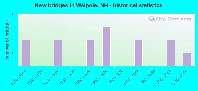
- New bridges - historical statistics
- 21910-1919
- 21930-1939
- 21950-1959
- 31960-1969
- 21980-1989
- 22000-2009
- 12010-2019
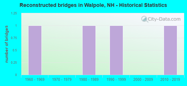
- Reconstructed bridges - Historical Statistics
- 11960-1969
- 01970-1979
- 11980-1989
- 11990-1999
- 02000-2009
- 12010-2019
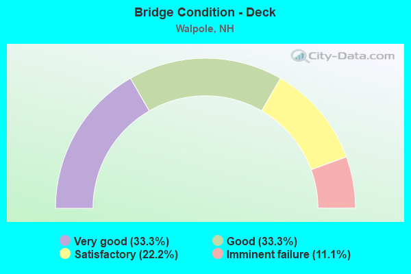
- Bridge Condition - Deck
- 33.3%Very good
- 33.3%Good
- 22.2%Satisfactory
- 11.1%Imminent failure
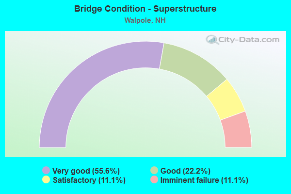
- Bridge Condition - Superstructure
- 55.6%Very good
- 22.2%Good
- 11.1%Satisfactory
- 11.1%Imminent failure

- Bridge Condition - Substructure
- 22.2%Very good
- 44.4%Good
- 11.1%Satisfactory
- 11.1%Fair
- 11.1%Imminent failure
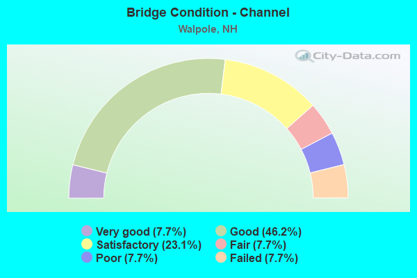
- Bridge Condition - Channel
- 7.7%Very good
- 46.2%Good
- 23.1%Satisfactory
- 7.7%Fair
- 7.7%Poor
- 7.7%Failed
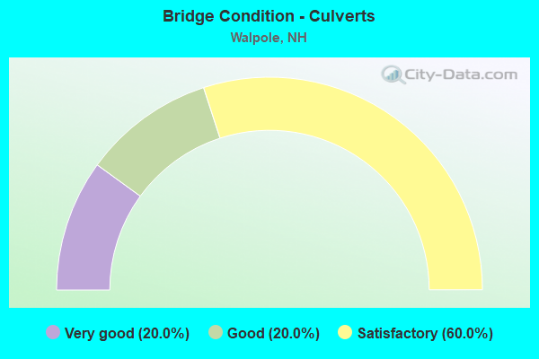
- Bridge Condition - Culverts
- 20.0%Very good
- 20.0%Good
- 60.0%Satisfactory
Find on map >> Show street view
Structure Number: 241005400163, Location: VERMONT STATE LINE (Lat: 45.007919, Lng: -71.507547), Route carried "on" structure: State highway , Year Built: 1930, Year Reconstructed: 2018, Status: Open, Structure Length: 7.07m (23.20ft), Average Daily Traffic: 481 (year 2020), Truck Traffic: 10%, Average Future Daily Traffic: 711 (year 2042), Design Load: H 15, Features Intersected: CONNECTICUT RIVER, Facility Carried by Structure: BRIDGE STREET
Minimum Vertical Clearance: 30+ m (98+ ft), Kilometerpoint: 0.303, Lanes on structure: 2, Owner: State Highway Agency, Approaching Roadway Width: 7.3m (24.0ft), Material/Design: Steel, Design/Construction: Arch - Deck, Number Of Spans In Main Unit: 1, Number Of Approach Spans: 10, Length of Maximum Span: 41.5m (136.2ft), Curb or Sidewalk Widths: Left: 1.5m (4.9ft), Right: 0.2m (0.7ft), Curb-To-Curb Width: 7.3m (24.0ft), Out-to-Out Width: 9.9m (32.5ft)
Condition: Deck: Good, Superstructure: Good, Substructure: Good, Channel: Good, Operating Rating: 39.6 metric tons, Method Used To Determine Operating Rating: Load Factor (LF), Inventory Rating: 23.7 metric tons, Method Used To Determine Inventory Rating: Load Factor (LF), Structural Evaluation: Equal to present minimum criteria, Deck Geometry: Meets minimum limits, Waterway Adequacy: Equal to present desirable criteria, Approach Roadway Alignment: Equal to present desirable criteria, Length Of Structure Improvement: 7.07m (23.20ft), Designated Inspection Frequency: Every 24 months, Critical Feature Inspection Frequency: Every 24 months, Inspection Date: May 2020, Critical Feature Inspection Date: May 2020, Bridge Improvement Cost: $2,718,000, Roadway Improvement Cost: $200,000, Total Project Cost: $3,142,000 ( Estimate for 2022), Deck Structure Type: Concrete Cast-file-Place, Wearing Surface/Protective System: Wearing Surface: Monolithic Concrete, Deck Protection: Galvanized Reinforcing
Find on map >> Show street view
Structure Number: 262005800043, Location: VERMONT STATE LINE (Lat: 43.138097, Lng: -72.448317), Route carried "on" structure: State highway 12, Year Built: 1983, Status: Open, Structure Length: 19.35m (63.48ft), Average Daily Traffic: 6,836 (year 2020), Truck Traffic: 4%, Average Future Daily Traffic: 10,117 (year 2042), Design Load: HS 20+Mod, Features Intersected: CONNECTICUT RIVER,NECRR, Facility Carried by Structure: CHURCH STREET
Minimum Vertical Clearance: 30+ m (98+ ft), Kilometerpoint: 0.064, Lanes on structure: 2, Owner: State Highway Agency, Approaching Roadway Width: 12.2m (40.0ft), Material/Design: Steel continuous, Design/Construction: Stringer/Multi-beam, Number Of Spans In Main Unit: 4, Length of Maximum Span: 68.3m (224.1ft), Curb or Sidewalk Widths: Left: 0.2m (0.7ft), Right: 1.8m (5.9ft), Curb-To-Curb Width: 12.0m (39.4ft), Out-to-Out Width: 14.8m (48.6ft)
Condition: Deck: Good, Superstructure: Good, Substructure: Good, Channel: Good, Operating Rating: 71.5 metric tons, Method Used To Determine Operating Rating: Load Factor (LF), Inventory Rating: 42.9 metric tons, Method Used To Determine Inventory Rating: Load Factor (LF), Structural Evaluation: Better than present minimum criteria, Deck Geometry: Somewhat better than minimum adequacy, Underclear: Equal to present minimum criteria, Waterway Adequacy: Equal to present desirable criteria, Approach Roadway Alignment: Equal to present desirable criteria, Length Of Structure Improvement: 19.35m (63.48ft), Designated Inspection Frequency: Every 24 months, Underwater Inspection Frequency: Every 60 months, Inspection Date: June 2020, Underwater Inspection Date: August 2017, Bridge Improvement Cost: $2,718,000, Roadway Improvement Cost: $200,000, Total Project Cost: $3,142,000 ( Estimate for 2022), Deck Structure Type: Concrete Cast-file-Place, Wearing Surface/Protective System: Wearing Surface: Bituminous, Membrane: Other
Find on map >> Show street view
Structure Number: 262006200052, Location: VERMONT STATE LINE (Lat: 43.135314, Lng: -72.440122), Route carried "on" structure: State highway 12, Year Built: 1930, Year Reconstructed: 1974, Status: Closed, Structure Length: 7.01m (23.00ft), Average Daily Traffic: 6,100 (year 2017), Truck Traffic: 4%, Average Future Daily Traffic: 9,028 (year 2042), Design Load: H 15, Features Intersected: CONNECTICUT RIVER, Facility Carried by Structure: BRIDGE STREET
Minimum Vertical Clearance: 30+ m (98+ ft), Kilometerpoint: 0.043, Lanes on structure: 2, Owner: State Highway Agency, Approaching Roadway Width: 7.3m (24.0ft), Material/Design: Concrete, Design/Construction: Arch - Deck, Number Of Spans In Main Unit: 2, Length of Maximum Span: 32.6m (107.0ft), Curb or Sidewalk Widths: Left: 0.2m (0.7ft), Right: 1.4m (4.6ft), Curb-To-Curb Width: 7.3m (24.0ft), Out-to-Out Width: 9.9m (32.5ft)
Condition: Deck: Imminent failure, Superstructure: Imminent failure, Substructure: Imminent failure, Channel: Failed, Waterway Adequacy: Superior to present desirable criteria, Approach Roadway Alignment: Meets minimum limits, Bridge Posting: Required (Relationship of Operating Rating to Maximum Legal Load: > 39.9% below), Length Of Structure Improvement: 7.01m (23.00ft), Designated Inspection Frequency: Every 8 months, Inspection Date: November 2021, Bridge Improvement Cost: $2,718,000, Roadway Improvement Cost: $200,000, Total Project Cost: $3,142,000 ( Estimate for 2022), Deck Structure Type: Concrete Cast-file-Place, Wearing Surface/Protective System: Wearing Surface: Bituminous, Membrane: Other
Find on map >> Show street view
Structure Number: 262006500105, Location: .22 MI SE LANGDON TL (Lat: 43.132142, Lng: -72.390161), Route carried "on" structure: State highway 123, Year Built: 1919, Status: Open, Structure Length: 1.80m (5.91ft), Average Daily Traffic: 2,460 (year 2020), Truck Traffic: 10%, Average Future Daily Traffic: 3,640 (year 2042), Design Load: H 15, Features Intersected: COLD RIVER
Minimum Vertical Clearance: 30+ m (98+ ft), Kilometerpoint: 92.370, Lanes on structure: 2, Owner: State Highway Agency, Approaching Roadway Width: 6.4m (21.0ft), Material/Design: Steel, Design/Construction: Girder and Floorbeam System, Number Of Spans In Main Unit: 1, Length of Maximum Span: 16.8m (55.1ft), Curb-To-Curb Width: 6.4m (21.0ft), Out-to-Out Width: 7.1m (23.3ft)
Condition: Deck: Satisfactory, Superstructure: Satisfactory, Substructure: Satisfactory, Channel: Satisfactory, Operating Rating: 20.9 metric tons, Method Used To Determine Operating Rating: Allowable Stress (AS), Inventory Rating: 12.7 metric tons, Method Used To Determine Inventory Rating: Allowable Stress (AS), Structural Evaluation: Meets minimum limits, Deck Geometry: High priority of replacement, Waterway Adequacy: Superior to present desirable criteria, Approach Roadway Alignment: Meets minimum limits, Length Of Structure Improvement: 1.80m (5.91ft), Designated Inspection Frequency: Every 24 months, Critical Feature Inspection Frequency: Every 24 months, Inspection Date: June 2020, Critical Feature Inspection Date: June 2020, Bridge Improvement Cost: $2,718,000, Roadway Improvement Cost: $200,000, Total Project Cost: $3,142,000 ( Estimate for 2022), Deck Structure Type: Concrete Cast-file-Place, Wearing Surface/Protective System: Wearing Surface: Bituminous
Find on map >> Show street view
Structure Number: 262007800066, Location: 1.34MI SE VT SL (Lat: 43.121819, Lng: -72.426489), Route carried "on" structure: State highway 123, Year Built: 2008, Status: Open, Structure Length: 3.29m (10.79ft), Average Daily Traffic: 2,460 (year 2020), Truck Traffic: 10%, Average Future Daily Traffic: 3,640 (year 2042), Design Load: HS 25 or greater, Features Intersected: COLD RIVER
Minimum Vertical Clearance: 30+ m (98+ ft), Kilometerpoint: 96.471, Lanes on structure: 2, Owner: State Highway Agency, Approaching Roadway Width: 8.2m (26.9ft), Material/Design: Prestressed concrete, Design/Construction: Box Beam or Girders - Multiple, Number Of Spans In Main Unit: 1, Length of Maximum Span: 32.0m (105.0ft), Curb or Sidewalk Widths: Left: 0.2m (0.7ft), Right: 0.2m (0.7ft), Curb-To-Curb Width: 10.4m (34.1ft), Out-to-Out Width: 11.7m (38.4ft)
Condition: Deck: Very good, Superstructure: Very good, Substructure: Very good, Channel: Good, Operating Rating: 89.8 metric tons, Method Used To Determine Operating Rating: Load Factor (LF), Inventory Rating: 50.3 metric tons, Method Used To Determine Inventory Rating: Load Factor (LF), Structural Evaluation: Equal to present desirable criteria, Deck Geometry: Somewhat better than minimum adequacy, Waterway Adequacy: Equal to present desirable criteria, Approach Roadway Alignment: Meets minimum limits, Length Of Structure Improvement: 3.29m (10.79ft), Designated Inspection Frequency: Every 24 months, Inspection Date: June 2020, Bridge Improvement Cost: $2,718,000, Roadway Improvement Cost: $200,000, Total Project Cost: $3,142,000 ( Estimate for 2022), Deck Structure Type: Concrete Cast-file-Place, Wearing Surface/Protective System: Wearing Surface: Bituminous, Membrane: Preformed Fabric, Deck Protection: Epoxy Coated Reinforcing
Find on map >> Show street view
Structure Number: 262008200065, Location: .1MI FROM JCT RT 123 (Lat: 43.119172, Lng: -72.429650), Route carried "on" structure: State highway 12, Year Built: 1960, Year Reconstructed: 2003, Status: Open, Structure Length: 6.96m (22.83ft), Average Daily Traffic: 6,010 (year 2020), Truck Traffic: 9%, Average Future Daily Traffic: 8,894 (year 2042), Design Load: HS 25 or greater, Features Intersected: COLD RIVER
Minimum Vertical Clearance: 30+ m (98+ ft), Kilometerpoint: 62.183, Lanes on structure: 2, Owner: State Highway Agency, Approaching Roadway Width: 13.4m (44.0ft), Skew: 2 degrees, Material/Design: Steel continuous, Design/Construction: Stringer/Multi-beam, Number Of Spans In Main Unit: 3, Length of Maximum Span: 24.4m (80.1ft), Curb or Sidewalk Widths: Left: 0.1m (0.3ft), Right: 0.1m (0.3ft), Curb-To-Curb Width: 13.4m (44.0ft), Out-to-Out Width: 14.3m (46.9ft)
Condition: Deck: Good, Superstructure: Very good, Substructure: Fair, Channel: Very good, Operating Rating: 56.3 metric tons, Method Used To Determine Operating Rating: Load Factor (LF), Inventory Rating: 40.8 metric tons, Method Used To Determine Inventory Rating: Load Factor (LF), Structural Evaluation: Somewhat better than minimum adequacy, Deck Geometry: Equal to present minimum criteria, Waterway Adequacy: Better than present minimum criteria, Approach Roadway Alignment: Equal to present desirable criteria, Length Of Structure Improvement: 6.96m (22.83ft), Designated Inspection Frequency: Every 24 months, Inspection Date: June 2020, Bridge Improvement Cost: $2,718,000, Roadway Improvement Cost: $200,000, Total Project Cost: $3,142,000 ( Estimate for 2022), Deck Structure Type: Concrete Cast-file-Place, Wearing Surface/Protective System: Wearing Surface: Bituminous, Membrane: Preformed Fabric, Deck Protection: Epoxy Coated Reinforcing
Find on map >> Show street view
Structure Number: 262013200062, Location: VERMONT STATE LINE (Lat: 43.084300, Lng: -72.433311), Route carried "on" structure: State highway 123, Year Built: 1910, Year Reconstructed: 1989, Status: Open, Structure Length: 14.26m (46.78ft), Average Daily Traffic: 5,698 (year 2020), Truck Traffic: 7%, Average Future Daily Traffic: 8,433 (year 2042), Design Load: HS 25 or greater, Features Intersected: CONNECTICUT RIVER
Minimum Vertical Clearance: 30+ m (98+ ft), Kilometerpoint: 101.410, Lanes on structure: 2, Owner: State Highway Agency, Approaching Roadway Width: 8.5m (27.9ft), Material/Design: Steel, Design/Construction: Stringer/Multi-beam, Number Of Spans In Main Unit: 3, Length of Maximum Span: 48.2m (158.1ft), Curb or Sidewalk Widths: Left: 0.2m (0.7ft), Right: 0.2m (0.7ft), Curb-To-Curb Width: 8.5m (27.9ft), Out-to-Out Width: 9.6m (31.5ft)
Condition: Deck: Satisfactory, Superstructure: Very good, Substructure: Good, Channel: Good, Operating Rating: 89.8 metric tons, Method Used To Determine Operating Rating: Load Factor (LF), Inventory Rating: 59.1 metric tons, Method Used To Determine Inventory Rating: Load Factor (LF), Structural Evaluation: Better than present minimum criteria, Deck Geometry: Meets minimum limits, Waterway Adequacy: Superior to present desirable criteria, Approach Roadway Alignment: Equal to present desirable criteria, Length Of Structure Improvement: 14.26m (46.78ft), Designated Inspection Frequency: Every 24 months, Inspection Date: June 2020, Bridge Improvement Cost: $2,718,000, Roadway Improvement Cost: $200,000, Total Project Cost: $3,142,000 ( Estimate for 2022), Deck Structure Type: Concrete Cast-file-Place, Wearing Surface/Protective System: Wearing Surface: Bituminous, Membrane: Preformed Fabric, Deck Protection: Epoxy Coated Reinforcing
Find on map >> Show street view
Structure Number: 262018200064, Location: 0.46 NNE OF NH RTE 12 JCT (Lat: 43.048167, Lng: -72.434517), Route carried "on" structure: Other road , Year Built: 2008, Status: Open, Structure Length: 1.01m (3.31ft), Average Daily Traffic: 202 (year 2020), Truck Traffic: 4%, Average Future Daily Traffic: 298 (year 2042), Design Load: HS 25 or greater, Features Intersected: GREAT BROOK, Facility Carried by Structure: OLD KEENE ROAD
Minimum Vertical Clearance: 30+ m (98+ ft), Kilometerpoint: 0.760, Lanes on structure: 2, Owner: City or Municipal Highway Agency, Approaching Roadway Width: 5.5m (18.0ft), Material/Design: Concrete, Design/Construction: Culvert, Number Of Spans In Main Unit: 1, Length of Maximum Span: 9.8m (32.2ft)
Condition: Channel: Poor, Culverts: Very good, Operating Rating: 75.0 metric tons, Method Used To Determine Operating Rating: Load Factor (LF), Inventory Rating: 53.0 metric tons, Method Used To Determine Inventory Rating: Load Factor (LF), Structural Evaluation: Equal to present desirable criteria, Waterway Adequacy: Equal to present desirable criteria, Approach Roadway Alignment: Equal to present desirable criteria, Length Of Structure Improvement: 1.01m (3.31ft), Designated Inspection Frequency: Every 24 months, Inspection Date: July 2021, Bridge Improvement Cost: $2,718,000, Roadway Improvement Cost: $200,000, Total Project Cost: $3,142,000 ( Estimate for 2022), Deck Structure Type: Concrete Precast Panels, Wearing Surface/Protective System: Wearing Surface: Bituminous, Membrane: Preformed Fabric
Find on map >> Show street view
Structure Number: 262018200068, Location: 0.22 MI FR OLD KEENE RD (Lat: 43.048467, Lng: -72.430222), Route carried "on" structure: Other road , Year Built: 2010, Status: Open, Structure Length: 0.88m (2.89ft), Average Daily Traffic: 214 (year 2020), Truck Traffic: 4%, Average Future Daily Traffic: 316 (year 2042), Features Intersected: GREAT BROOK, Facility Carried by Structure: MILL ROAD
Minimum Vertical Clearance: 30+ m (98+ ft), Kilometerpoint: 0.357, Lanes on structure: 2, Owner: City or Municipal Highway Agency, Approaching Roadway Width: 5.5m (18.0ft), Material/Design: Concrete, Design/Construction: Slab, Number Of Spans In Main Unit: 1, Length of Maximum Span: 7.6m (24.9ft), Curb-To-Curb Width: 7.3m (24.0ft), Out-to-Out Width: 7.6m (24.9ft)
Condition: Deck: Very good, Superstructure: Very good, Substructure: Very good, Channel: Fair, Inventory Rating: 78.0 metric tons, Method Used To Determine Inventory Rating: Load Factor (LF), Structural Evaluation: Equal to present desirable criteria, Deck Geometry: Somewhat better than minimum adequacy, Waterway Adequacy: Equal to present desirable criteria, Approach Roadway Alignment: Better than present minimum criteria, Length Of Structure Improvement: 0.88m (2.89ft), Designated Inspection Frequency: Every 24 months, Inspection Date: July 2021, Bridge Improvement Cost: $2,718,000, Roadway Improvement Cost: $200,000, Total Project Cost: $3,142,000 ( Estimate for 2022), Deck Structure Type: Concrete Cast-file-Place, Wearing Surface/Protective System: Wearing Surface: Integral Concrete, Deck Protection: Epoxy Coated Reinforcing
Find on map >> Show street view
Structure Number: 262018300081, Location: 5.52 MI SURRY TL (Lat: 43.047186, Lng: -72.419383), Route carried "on" structure: State highway , Year Built: 1968, Status: Open, Structure Length: 0.61m (2.00ft), Average Daily Traffic: 316 (year 2020), Truck Traffic: 4%, Average Future Daily Traffic: 467 (year 2042), Design Load: H 20, Features Intersected: GREAT BROOK, Facility Carried by Structure: COUNTY ROAD
Minimum Vertical Clearance: 30+ m (98+ ft), Kilometerpoint: 3.166, Lanes on structure: 2, Owner: State Highway Agency, Approaching Roadway Width: 5.5m (18.0ft), Material/Design: Steel, Design/Construction: Culvert, Number Of Spans In Main Unit: 1, Length of Maximum Span: 6.1m (20.0ft)
Condition: Channel: Good, Culverts: Good, Operating Rating: 53.5 metric tons, Method Used To Determine Operating Rating: Load Factor (LF), Inventory Rating: 32.7 metric tons, Method Used To Determine Inventory Rating: Load Factor (LF), Structural Evaluation: Better than present minimum criteria, Waterway Adequacy: Equal to present desirable criteria, Approach Roadway Alignment: Equal to present desirable criteria, Length Of Structure Improvement: 0.61m (2.00ft), Designated Inspection Frequency: Every 24 months, Inspection Date: June 2020, Bridge Improvement Cost: $2,718,000, Roadway Improvement Cost: $200,000, Total Project Cost: $3,142,000 ( Estimate for 2022)
Find on map >> Show street view
Structure Number: 262018600072, Location: 1.9 MI FR WESTMORELAND T (Lat: 43.044881, Lng: -72.427853), Route carried "on" structure: Other road , Year Built: 1950, Status: Open, Structure Length: 0.67m (2.20ft), Average Daily Traffic: 284 (year 2020), Truck Traffic: 4%, Average Future Daily Traffic: 420 (year 2042), Features Intersected: GREAT BROOK, Facility Carried by Structure: WENTWORTH ROAD
Minimum Vertical Clearance: 30+ m (98+ ft), Kilometerpoint: 3.001, Lanes on structure: 2, Owner: City or Municipal Highway Agency, Approaching Roadway Width: 5.5m (18.0ft), Skew: 2 degrees, Material/Design: Steel, Design/Construction: Culvert, Number Of Spans In Main Unit: 1, Length of Maximum Span: 6.7m (22.0ft)
Condition: Channel: Satisfactory, Culverts: Satisfactory, Operating Rating: 58.4 metric tons, Method Used To Determine Operating Rating: Load Factor (LF), Inventory Rating: 35.1 metric tons, Method Used To Determine Inventory Rating: Load Factor (LF), Structural Evaluation: Equal to present minimum criteria, Waterway Adequacy: Equal to present desirable criteria, Approach Roadway Alignment: Equal to present minimum criteria, Length Of Structure Improvement: 0.67m (2.20ft), Designated Inspection Frequency: Every 24 months, Inspection Date: July 2021, Bridge Improvement Cost: $2,718,000, Roadway Improvement Cost: $200,000, Total Project Cost: $3,142,000 ( Estimate for 2022)
Find on map >> Show street view
Structure Number: 262019600046, Location: 1.4 MI FR WESTMORELAND T (Lat: 43.038294, Lng: -72.454022), Route carried "on" structure: Other road , Year Built: 1950, Status: Open, Structure Length: 1.07m (3.51ft), Average Daily Traffic: 111 (year 2020), Truck Traffic: 4%, Average Future Daily Traffic: 164 (year 2042), Features Intersected: GREAT BROOK, Facility Carried by Structure: SOUTH RIVER ROAD
Minimum Vertical Clearance: 30+ m (98+ ft), Kilometerpoint: 2.205, Lanes on structure: 2, Owner: City or Municipal Highway Agency, Approaching Roadway Width: 6.4m (21.0ft), Material/Design: Steel, Design/Construction: Culvert, Number Of Spans In Main Unit: 2, Length of Maximum Span: 4.6m (15.1ft)
Condition: Channel: Satisfactory, Culverts: Satisfactory, Operating Rating: 76.4 metric tons, Method Used To Determine Operating Rating: Load Factor (LF), Inventory Rating: 45.7 metric tons, Method Used To Determine Inventory Rating: Load Factor (LF), Structural Evaluation: Equal to present minimum criteria, Waterway Adequacy: Equal to present desirable criteria, Approach Roadway Alignment: Somewhat better than minimum adequacy, Length Of Structure Improvement: 1.07m (3.51ft), Designated Inspection Frequency: Every 24 months, Inspection Date: July 2021, Bridge Improvement Cost: $2,718,000, Roadway Improvement Cost: $200,000, Total Project Cost: $3,142,000 ( Estimate for 2022)
Find on map >> Show street view
Structure Number: 26202080006, Location: .8MI WESTMORELAND TL (Lat: 43.031003, Lng: -72.439208), Route carried "on" structure: State highway 12, Year Built: 1960, Status: Open, Structure Length: 1.46m (4.79ft), Average Daily Traffic: 6,934 (year 2020), Truck Traffic: 7%, Average Future Daily Traffic: 10,262 (year 2042), Design Load: HS 20, Features Intersected: NHRR(ABD)
Minimum Vertical Clearance: 30+ m (98+ ft), Kilometerpoint: 51.768, Lanes on structure: 2, Owner: State Highway Agency, Approaching Roadway Width: 11.0m (36.1ft), Skew: 4 degrees, Material/Design: Concrete, Design/Construction: Frame, Number Of Spans In Main Unit: 1, Length of Maximum Span: 13.4m (44.0ft), Curb-To-Curb Width: 12.1m (39.7ft), Out-to-Out Width: 13.3m (43.6ft)
Condition: Deck: Very good, Superstructure: Very good, Substructure: Good, Operating Rating: 49.0 metric tons, Method Used To Determine Operating Rating: Load Factor (LF), Inventory Rating: 24.5 metric tons, Method Used To Determine Inventory Rating: Load Factor (LF), Structural Evaluation: Equal to present minimum criteria, Deck Geometry: Somewhat better than minimum adequacy, Underclear: Equal to present minimum criteria, Approach Roadway Alignment: Equal to present minimum criteria, Length Of Structure Improvement: 1.46m (4.79ft), Designated Inspection Frequency: Every 24 months, Inspection Date: June 2020, Bridge Improvement Cost: $2,718,000, Roadway Improvement Cost: $200,000, Total Project Cost: $3,142,000 ( Estimate for 2022), Deck Structure Type: Concrete Cast-file-Place, Wearing Surface/Protective System: Wearing Surface: Bituminous, Membrane: Other
Find on map >> Show street view
Structure Number: 262021600047, Location: 0.4 MI FR WESTMORELAND T (Lat: 43.024814, Lng: -72.453192), Route carried "on" structure: Other road , Year Built: 1980, Status: Open, Structure Length: 0.64m (2.10ft), Average Daily Traffic: 88 (year 2020), Truck Traffic: 4%, Average Future Daily Traffic: 130 (year 2042), Features Intersected: HOUGHTON BROOK, Facility Carried by Structure: SOUTH RIVER ROAD
Minimum Vertical Clearance: 30+ m (98+ ft), Kilometerpoint: 0.668, Lanes on structure: 2, Owner: City or Municipal Highway Agency, Approaching Roadway Width: 6.4m (21.0ft), Material/Design: Steel, Design/Construction: Culvert, Number Of Spans In Main Unit: 2, Length of Maximum Span: 3.0m (9.8ft)
Condition: Channel: Good, Culverts: Satisfactory, Operating Rating: 27.4 metric tons, Method Used To Determine Operating Rating: Allowable Stress (AS), Inventory Rating: 16.5 metric tons, Method Used To Determine Inventory Rating: Allowable Stress (AS), Structural Evaluation: Somewhat better than minimum adequacy, Waterway Adequacy: Equal to present desirable criteria, Approach Roadway Alignment: Equal to present desirable criteria, Length Of Structure Improvement: 0.64m (2.10ft), Designated Inspection Frequency: Every 24 months, Inspection Date: July 2021, Bridge Improvement Cost: $2,718,000, Roadway Improvement Cost: $200,000, Total Project Cost: $3,142,000 ( Estimate for 2022)