Bridge Statistics for Washington, Utah (UT)
Condition, Traffic, Stress, Structural Evaluation, Project Costs
- National Bridge Inventory (NBI) Statistics
- 32Number of bridges
- 249ft / 76.0mTotal length
- 669,766Total average daily traffic
- 127,812Total average daily truck traffic
- National Bridge Inventory (NBI) Registered Bridges for Washington
- No street view available for this location
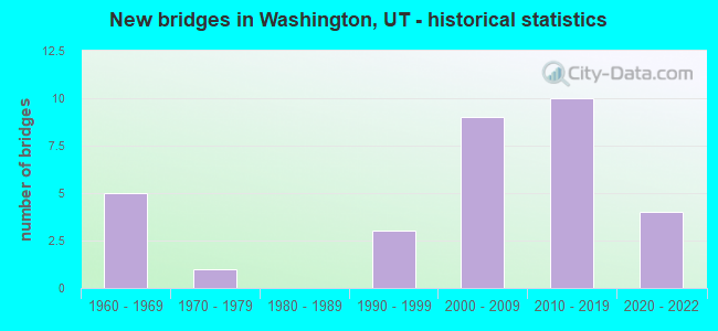
- New bridges - historical statistics
- 51960-1969
- 11970-1979
- 31990-1999
- 92000-2009
- 102010-2019
- 42020-2022
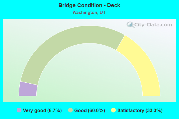
- Bridge Condition - Deck
- 6.7%Very good
- 60.0%Good
- 33.3%Satisfactory
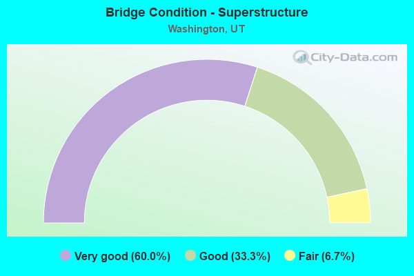
- Bridge Condition - Superstructure
- 60.0%Very good
- 33.3%Good
- 6.7%Fair
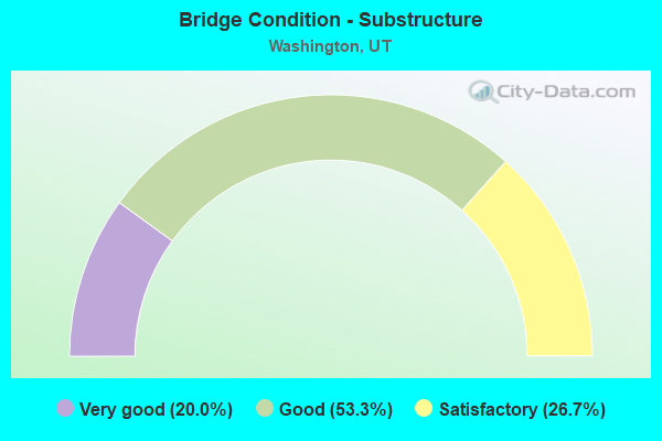
- Bridge Condition - Substructure
- 20.0%Very good
- 53.3%Good
- 26.7%Satisfactory
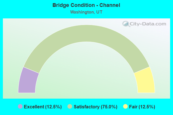
- Bridge Condition - Channel
- 12.5%Excellent
- 75.0%Satisfactory
- 12.5%Fair
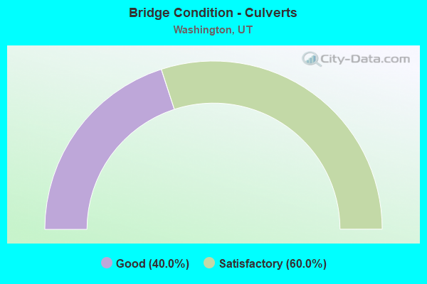
- Bridge Condition - Culverts
- 40.0%Good
- 60.0%Satisfactory
Find on map >> Show street view
Structure Number: 53005F, Location: SOUTH SIDE OF WASHINGTON (Lat: 37.116053, Lng: -113.500753), Route carried "on" structure: City street 3158, Year Built: 1976, Year Reconstructed: 2011, Status: Open, Structure Length: 7.07m (23.20ft), Average Daily Traffic: 13,697 (year 2020), Average Future Daily Traffic: 17,121 (year 2040), Design Load: HS 20+Mod, Features Intersected: VIRGIN RIVER, Facility Carried by Structure: CITY STREET
Minimum Vertical Clearance: 30+ m (98+ ft), Kilometerpoint: 9.462, Lanes on structure: 5, Owner: City or Municipal Highway Agency, Approaching Roadway Width: 21.0m (68.9ft), Skew: 1 degrees, Material/Design: Prestressed concrete continuous, Design/Construction: Stringer/Multi-beam, Number Of Spans In Main Unit: 3, Length of Maximum Span: 23.3m (76.4ft), Curb or Sidewalk Widths: Left: 2.0m (6.6ft), Right: 2.0m (6.6ft), Curb-To-Curb Width: 21.0m (68.9ft), Out-to-Out Width: 24.9m (81.7ft)
Condition: Deck: Satisfactory, Superstructure: Good, Substructure: Satisfactory, Channel: Satisfactory, Operating Rating: 37.3 metric tons, Method Used To Determine Operating Rating: Load and Resistance Factor Rating (LRFR) rating reported by rating factor(RF) method using HL-93 loadings, Inventory Rating: 31.4 metric tons, Method Used To Determine Inventory Rating: Load Factor (LF) rating reported by rating factor (RF) method using MS18 loading, Structural Evaluation: Equal to present minimum criteria, Deck Geometry: Somewhat better than minimum adequacy, Waterway Adequacy: Equal to present minimum criteria, Approach Roadway Alignment: Equal to present desirable criteria, Designated Inspection Frequency: Every 24 months, Inspection Date: Febuary 2020, Deck Structure Type: Concrete Cast-file-Place, Wearing Surface/Protective System: Wearing Surface: Monolithic Concrete
Find on map >> Show street view
Structure Number: 53018E, Location: AT INT. WITH LANDFILL RD. (Lat: 37.142700, Lng: -113.458250), Route carried "on" structure: City street 3154, Year Built: 2001, Status: Open, Structure Length: 0.95m (3.12ft), Average Daily Traffic: 7,061 (year 2020), Average Future Daily Traffic: 8,826 (year 2040), Design Load: HS 20+Mod, Features Intersected: COTTONWOOD WASH, Facility Carried by Structure: TELEGRAPH ROAD
Minimum Vertical Clearance: 30+ m (98+ ft), Kilometerpoint: 6.638, Lanes on structure: 4, Owner: City or Municipal Highway Agency, Approaching Roadway Width: 24.4m (80.1ft), Skew: 21 degrees, Material/Design: Concrete continuous, Design/Construction: Culvert, Number Of Spans In Main Unit: 2, Length of Maximum Span: 4.3m (14.1ft), Curb-To-Curb Width: 24.4m (80.1ft), Out-to-Out Width: 34.6m (113.5ft)
Condition: Channel: Satisfactory, Culverts: Good, Operating Rating: 52.2 metric tons, Method Used To Determine Operating Rating: Load and Resistance Factor Rating (LRFR) rating reported by rating factor(RF) method using HL-93 loadings, Inventory Rating: 30.8 metric tons, Method Used To Determine Inventory Rating: Load Factor (LF) rating reported by rating factor (RF) method using MS18 loading, Structural Evaluation: Better than present minimum criteria, Deck Geometry: Superior to present desirable criteria, Waterway Adequacy: Equal to present desirable criteria, Approach Roadway Alignment: Equal to present desirable criteria, Designated Inspection Frequency: Every 24 months, Inspection Date: Febuary 2022
Find on map >> Show street view
Structure Number: 53027E, Location: 320 W. 200 S., WASHINGTON (Lat: 37.127753, Lng: -113.515375), Route carried "on" structure: City street , Year Built: 2002, Status: Open, Structure Length: 0.93m (3.05ft), Average Daily Traffic: 630 (year 2020), Truck Traffic: 10%, Average Future Daily Traffic: 765 (year 2040), Design Load: HS 20+Mod, Features Intersected: MILL CREEK, Facility Carried by Structure: 200 SOUTH STREET
Minimum Vertical Clearance: 30+ m (98+ ft), Kilometerpoint: 0.168, Lanes on structure: 2, Owner: City or Municipal Highway Agency, Approaching Roadway Width: 9.3m (30.5ft), Skew: 3 degrees, Material/Design: Concrete continuous, Design/Construction: Culvert, Number Of Spans In Main Unit: 2, Length of Maximum Span: 4.2m (13.8ft)
Condition: Channel: Satisfactory, Culverts: Satisfactory, Operating Rating: 43.7 metric tons, Method Used To Determine Operating Rating: Load Factor (LF) rating reported by rating factor (RF) method using MS18 loading, Inventory Rating: 30.5 metric tons, Method Used To Determine Inventory Rating: Load and Resistance Factor Rating (LRFR) rating reported by rating factor(RF) method using HL-93 loadings, Structural Evaluation: Equal to present minimum criteria, Waterway Adequacy: Equal to present desirable criteria, Approach Roadway Alignment: Equal to present desirable criteria, Designated Inspection Frequency: Every 24 months, Inspection Date: Febuary 2022
Find on map >> Show street view
Structure Number: 53028E, Location: NW SIDE OF WASHINGTON (Lat: 37.135600, Lng: -113.517442), Route carried "on" structure: City street 3190, Year Built: 1999, Status: Open, Structure Length: 0.84m (2.76ft), Average Daily Traffic: 1,000 (year 2020), Average Future Daily Traffic: 1,250 (year 2040), Design Load: HS 20+Mod, Features Intersected: MILL CREEK, Facility Carried by Structure: BUENA VISTA BLVD.
Minimum Vertical Clearance: 30+ m (98+ ft), Kilometerpoint: 16.789, Lanes on structure: 2, Owner: City or Municipal Highway Agency, Approaching Roadway Width: 19.5m (64.0ft), Skew: 1 degrees, Material/Design: Concrete continuous, Design/Construction: Culvert, Number Of Spans In Main Unit: 2, Length of Maximum Span: 3.8m (12.5ft)
Condition: Channel: Fair, Culverts: Satisfactory, Operating Rating: 32.4 metric tons, Method Used To Determine Operating Rating: Load Factor (LF) rating reported by rating factor (RF) method using MS18 loading, Inventory Rating: 32.1 metric tons, Method Used To Determine Inventory Rating: Load Factor (LF) rating reported by rating factor (RF) method using MS18 loading, Structural Evaluation: Equal to present minimum criteria, Waterway Adequacy: Better than present minimum criteria, Approach Roadway Alignment: Equal to present desirable criteria, Designated Inspection Frequency: Every 24 months, Inspection Date: Febuary 2022, Wearing Surface/Protective System: Wearing Surface: Bituminous
Find on map >> Show street view
Structure Number: 53047F, Location: SUNRISE VALLEY DRIVE (Lat: 37.120031, Lng: -113.466503), Route carried "on" structure: County highway , Year Built: 2013, Status: Open, Structure Length: 6.19m (20.31ft), Average Daily Traffic: 100 (year 2020), Average Future Daily Traffic: 125 (year 2040), Design Load: HL 93, Features Intersected: VIRGIN RIVER, Facility Carried by Structure: COUNTRY WAY
Minimum Vertical Clearance: 30+ m (98+ ft), Kilometerpoint: 0.416, Lanes on structure: 2, Owner: City or Municipal Highway Agency, Approaching Roadway Width: 9.6m (31.5ft), Material/Design: Prestressed concrete, Design/Construction: Stringer/Multi-beam, Number Of Spans In Main Unit: 2, Length of Maximum Span: 34.7m (113.8ft), Curb or Sidewalk Widths: Left: 3.0m (9.8ft), Right: 0.0m, Curb-To-Curb Width: 9.6m (31.5ft), Out-to-Out Width: 14.0m (45.9ft)
Condition: Deck: Satisfactory, Superstructure: Very good, Substructure: Satisfactory, Channel: Satisfactory, Operating Rating: 70.0 metric tons, Method Used To Determine Operating Rating: Load and Resistance Factor Rating (LRFR) rating reported by rating factor(RF) method using HL-93 loadings, Inventory Rating: 44.1 metric tons, Method Used To Determine Inventory Rating: Load and Resistance Factor Rating (LRFR) rating reported by rating factor(RF) method using HL-93 loadings, Structural Evaluation: Equal to present minimum criteria, Deck Geometry: Better than present minimum criteria, Waterway Adequacy: Better than present minimum criteria, Approach Roadway Alignment: Equal to present desirable criteria, Designated Inspection Frequency: Every 24 months, Inspection Date: Febuary 2022, Deck Structure Type: Concrete Cast-file-Place, Wearing Surface/Protective System: Wearing Surface: Monolithic Concrete, Deck Protection: Epoxy Coated Reinforcing
Find on map >> Show street view
Structure Number: 53062E, Location: 300 EAST INDUSTRIAL ROAD (Lat: 37.116944, Lng: -113.502500), Route carried "on" structure: Business City street 3205, Year Built: 2008, Status: Open, Structure Length: 1.26m (4.13ft), Average Daily Traffic: 7,368 (year 2020), Average Future Daily Traffic: 9,210 (year 2040), Design Load: HS 20+Mod, Features Intersected: MILL CREEK, Facility Carried by Structure: INDUSTRIAL ROAD
Minimum Vertical Clearance: 30+ m (98+ ft), Kilometerpoint: 4.252, Lanes on structure: 3, Owner: City or Municipal Highway Agency, Approaching Roadway Width: 14.0m (45.9ft), Skew: 2 degrees, Material/Design: Concrete, Design/Construction: Culvert, Number Of Spans In Main Unit: 3, Length of Maximum Span: 4.5m (14.8ft), Curb or Sidewalk Widths: Left: 1.5m (4.9ft), Right: 1.5m (4.9ft)
Condition: Channel: Satisfactory, Culverts: Good, Operating Rating: 32.4 metric tons, Method Used To Determine Operating Rating: Load Factor (LF) rating reported by rating factor (RF) method using MS18 loading, Inventory Rating: 13.0 metric tons, Method Used To Determine Inventory Rating: Load Factor (LF) rating reported by rating factor (RF) method using MS18 loading, Structural Evaluation: High priority of corrective action, Waterway Adequacy: Equal to present desirable criteria, Approach Roadway Alignment: Equal to present desirable criteria, Designated Inspection Frequency: Every 24 months, Inspection Date: Febuary 2020
Find on map >> Show street view
Structure Number: C 922, Location: MP 13 access road (Lat: 37.146811, Lng: -113.487189), Route carried "on" structure: City street 3153, Year Built: 2005, Status: Open, Structure Length: 9.85m (32.32ft), Average Daily Traffic: 2,012 (year 2020), Average Future Daily Traffic: 2,515 (year 2040), Design Load: HL 93, Features Intersected: I-15 NB AND SB, Facility Carried by Structure: WASHINGTON PARKWAY
Minimum Vertical Clearance: 30+ m (98+ ft), Kilometerpoint: 1.755, Lanes on structure: 4, Lanes under structure: 4, Base Highway Network: Yes, Owner: State Highway Agency, Approaching Roadway Width: 27.9m (91.5ft), Material/Design: Steel, Design/Construction: Stringer/Multi-beam, Number Of Spans In Main Unit: 2, Number Of Approach Spans: 2, Length of Maximum Span: 49.2m (161.4ft), Curb or Sidewalk Widths: Left: 1.8m (5.9ft), Right: 0.0m, Curb-To-Curb Width: 27.9m (91.5ft), Out-to-Out Width: 27.9m (91.5ft)
Condition: Deck: Satisfactory, Superstructure: Very good, Substructure: Good, Operating Rating: 62.2 metric tons, Method Used To Determine Operating Rating: Load and Resistance Factor Rating (LRFR) rating reported by rating factor(RF) method using HL-93 loadings, Inventory Rating: 33.4 metric tons, Method Used To Determine Inventory Rating: Load and Resistance Factor Rating (LRFR) rating reported by rating factor(RF) method using HL-93 loadings, Structural Evaluation: Better than present minimum criteria, Deck Geometry: Superior to present desirable criteria, Underclear: Better than present minimum criteria, Approach Roadway Alignment: Equal to present desirable criteria, Designated Inspection Frequency: Every 24 months, Inspection Date: January 2021, Deck Structure Type: Concrete Cast-file-Place, Wearing Surface/Protective System: Wearing Surface: Monolithic Concrete, Deck Protection: Epoxy Coated Reinforcing
Find on map >> Show street view
Structure Number: E1329, Location: 0.6 MI NO WASHINGTON INT. (Lat: 37.133883, Lng: -113.517264), Route carried "on" structure: Interstate 15, Year Built: 1964, Status: Open, Structure Length: 0.83m (2.72ft), Average Daily Traffic: 54,663 (year 2020), Truck Traffic: 23%, Average Future Daily Traffic: 68,329 (year 2040), Design Load: HS 20, Features Intersected: MILL CREEK
Minimum Vertical Clearance: 30+ m (98+ ft), Kilometerpoint: 18.545, Lanes on structure: 4, Base Highway Network: Yes, Owner: State Highway Agency, Approaching Roadway Width: 23.2m (76.1ft), Skew: 33 degrees, Material/Design: Concrete continuous, Design/Construction: Culvert, Number Of Spans In Main Unit: 2, Length of Maximum Span: 3.7m (12.1ft)
Condition: Channel: Satisfactory, Culverts: Satisfactory, Operating Rating: 97.2 metric tons, Method Used To Determine Operating Rating: Load Factor (LF) rating reported by rating factor (RF) method using MS18 loading, Inventory Rating: 96.9 metric tons, Method Used To Determine Inventory Rating: Load Factor (LF) rating reported by rating factor (RF) method using MS18 loading, Structural Evaluation: Equal to present minimum criteria, Waterway Adequacy: Meets minimum limits, Approach Roadway Alignment: Equal to present desirable criteria, Designated Inspection Frequency: Every 24 months, Inspection Date: January 2021
Find on map >> Show street view
Structure Number: F 672, Location: 0.5 MI.EAST Of I-15 INT. (Lat: 37.163592, Lng: -113.444931), Route carried "on" structure: State highway 9, Year Built: 1999, Status: Open, Structure Length: 3.52m (11.55ft), Average Daily Traffic: 26,547 (year 2020), Truck Traffic: 14%, Average Future Daily Traffic: 33,184 (year 2040), Design Load: HS 20+Mod, Features Intersected: CORAL CANYON BOULEVARD
Minimum Vertical Clearance: 30+ m (98+ ft), Kilometerpoint: 0.830, Lanes on structure: 6, Lanes under structure: 2, Base Highway Network: Yes, Owner: State Highway Agency, Approaching Roadway Width: 33.5m (109.9ft), Skew: 20 degrees, Material/Design: Prestressed concrete, Design/Construction: Stringer/Multi-beam, Number Of Spans In Main Unit: 1, Length of Maximum Span: 34.4m (112.9ft), Curb-To-Curb Width: 34.1m (111.9ft), Out-to-Out Width: 35.1m (115.2ft)
Condition: Deck: Good, Superstructure: Good, Substructure: Good, Operating Rating: 50.5 metric tons, Method Used To Determine Operating Rating: Load and Resistance Factor Rating (LRFR) rating reported by rating factor(RF) method using HL-93 loadings, Inventory Rating: 48.0 metric tons, Method Used To Determine Inventory Rating: Load and Resistance Factor Rating (LRFR) rating reported by rating factor(RF) method using HL-93 loadings, Structural Evaluation: Better than present minimum criteria, Deck Geometry: Superior to present desirable criteria, Underclear: Meets minimum limits, Approach Roadway Alignment: Equal to present desirable criteria, Designated Inspection Frequency: Every 24 months, Inspection Date: January 2021, Deck Structure Type: Concrete Cast-file-Place, Wearing Surface/Protective System: Wearing Surface: Monolithic Concrete, Deck Protection: Epoxy Coated Reinforcing
Find on map >> Show street view
Structure Number: F 845, Location: Airport Access Road (Lat: 37.059000, Lng: -113.485800), Route carried "on" structure: State highway 7, Year Built: 2013, Status: Open, Structure Length: 4.22m (13.85ft), Average Daily Traffic: 2,527 (year 2020), Truck Traffic: 12%, Average Future Daily Traffic: 3,159 (year 2040), Design Load: HL 93, Features Intersected: Warner Valley Road
Minimum Vertical Clearance: 30+ m (98+ ft), Kilometerpoint: 16.995, Lanes on structure: 2, Lanes under structure: 3, Owner: State Highway Agency, Approaching Roadway Width: 12.9m (42.3ft), Material/Design: Prestressed concrete, Design/Construction: Stringer/Multi-beam, Number Of Spans In Main Unit: 1, Length of Maximum Span: 41.2m (135.2ft), Curb-To-Curb Width: 12.9m (42.3ft), Out-to-Out Width: 13.8m (45.3ft)
Condition: Deck: Good, Superstructure: Very good, Substructure: Good, Operating Rating: 71.3 metric tons, Method Used To Determine Operating Rating: Load and Resistance Factor Rating (LRFR) rating reported by rating factor(RF) method using HL-93 loadings, Inventory Rating: 44.4 metric tons, Method Used To Determine Inventory Rating: Load and Resistance Factor Rating (LRFR) rating reported by rating factor(RF) method using HL-93 loadings, Structural Evaluation: Better than present minimum criteria, Deck Geometry: Equal to present minimum criteria, Underclear: Equal to present minimum criteria, Approach Roadway Alignment: Equal to present desirable criteria, Designated Inspection Frequency: Every 24 months, Inspection Date: January 2021, Deck Structure Type: Concrete Cast-file-Place, Wearing Surface/Protective System: Wearing Surface: Monolithic Concrete, Deck Protection: Epoxy Coated Reinforcing
Find on map >> Show street view
Structure Number: V2111, Location: In Washington City (Lat: 37.130003, Lng: -113.515458), Route carried "on" structure: City street 3154, Year Built: 2012, Status: Open, Structure Length: 0.81m (2.66ft), Average Daily Traffic: 17,284 (year 2020), Average Future Daily Traffic: 21,605 (year 2040), Design Load: HL 93, Features Intersected: MILL CREEK, Facility Carried by Structure: SR-212,TELGRPH ST.
Minimum Vertical Clearance: 30+ m (98+ ft), Kilometerpoint: 1.151, Lanes on structure: 5, Owner: State Highway Agency, Approaching Roadway Width: 23.2m (76.1ft), Skew: 32 degrees, Material/Design: Concrete, Design/Construction: Slab, Number Of Spans In Main Unit: 1, Length of Maximum Span: 8.1m (26.6ft), Curb or Sidewalk Widths: Left: 1.5m (4.9ft), Right: 1.5m (4.9ft), Curb-To-Curb Width: 23.2m (76.1ft), Out-to-Out Width: 39.6m (129.9ft)
Condition: Deck: Very good, Superstructure: Very good, Substructure: Good, Channel: Excellent, Operating Rating: 97.2 metric tons, Method Used To Determine Operating Rating: Load and Resistance Factor Rating (LRFR) rating reported by rating factor(RF) method using HL-93 loadings, Inventory Rating: 96.9 metric tons, Method Used To Determine Inventory Rating: Load and Resistance Factor Rating (LRFR) rating reported by rating factor(RF) method using HL-93 loadings, Structural Evaluation: Better than present minimum criteria, Deck Geometry: Better than present minimum criteria, Waterway Adequacy: Superior to present desirable criteria, Approach Roadway Alignment: Equal to present desirable criteria, Designated Inspection Frequency: Every 24 months, Inspection Date: January 2021, Deck Structure Type: Concrete Precast Panels, Wearing Surface/Protective System: Wearing Surface: Bituminous, Deck Protection: Epoxy Coated Reinforcing
Find on map >> Show street view
Structure Number: 1C 914, Location: Washington Int. (Lat: 37.128422, Lng: -113.525411), Route carried "on" structure: Interstate 15, Year Built: 2003, Status: Open, Structure Length: 5.87m (19.26ft), Average Daily Traffic: 54,663 (year 2020), Truck Traffic: 23%, Average Future Daily Traffic: 68,329 (year 2040), Design Load: HL 93, Features Intersected: SR-212, SPUI.INT.X-Road.
Minimum Vertical Clearance: 30+ m (98+ ft), Kilometerpoint: 17.600, Lanes on structure: 2, Lanes under structure: 6, Base Highway Network: Yes, Owner: State Highway Agency, Approaching Roadway Width: 17.8m (58.4ft), Skew: 1 degrees, Material/Design: Steel, Design/Construction: Stringer/Multi-beam, Number Of Spans In Main Unit: 1, Length of Maximum Span: 57.9m (190.0ft), Curb-To-Curb Width: 18.0m (59.1ft), Out-to-Out Width: 18.9m (62.0ft)
Condition: Deck: Satisfactory, Superstructure: Very good, Substructure: Good, Operating Rating: 57.0 metric tons, Method Used To Determine Operating Rating: Load and Resistance Factor Rating (LRFR) rating reported by rating factor(RF) method using HL-93 loadings, Inventory Rating: 41.1 metric tons, Method Used To Determine Inventory Rating: Load and Resistance Factor Rating (LRFR) rating reported by rating factor(RF) method using HL-93 loadings, Structural Evaluation: Better than present minimum criteria, Deck Geometry: Superior to present desirable criteria, Underclear: Meets minimum limits, Approach Roadway Alignment: Equal to present desirable criteria, Designated Inspection Frequency: Every 24 months, Inspection Date: January 2021, Deck Structure Type: Concrete Cast-file-Place, Wearing Surface/Protective System: Wearing Surface: Epoxy Overlay, Deck Protection: Epoxy Coated Reinforcing
Find on map >> Show street view
Structure Number: 1D 738, Location: 1.1 MI.NO.WASHINGTON INT (Lat: 37.138431, Lng: -113.510133), Route carried "on" structure: Interstate 15, Year Built: 1964, Status: Open, Structure Length: 3.51m (11.52ft), Average Daily Traffic: 54,663 (year 2020), Truck Traffic: 23%, Average Future Daily Traffic: 68,329 (year 2040), Design Load: HS 20+Mod, Features Intersected: WASHINGTON MAIN STREET
Minimum Vertical Clearance: 30+ m (98+ ft), Kilometerpoint: 19.355, Lanes on structure: 2, Lanes under structure: 2, Base Highway Network: Yes, Owner: State Highway Agency, Approaching Roadway Width: 11.6m (38.1ft), Skew: 3 degrees, Material/Design: Concrete continuous, Design/Construction: Tee Beam, Number Of Spans In Main Unit: 3, Length of Maximum Span: 13.4m (44.0ft), Curb-To-Curb Width: 11.6m (38.1ft), Out-to-Out Width: 12.6m (41.3ft)
Condition: Deck: Good, Superstructure: Fair, Substructure: Good, Operating Rating: 38.6 metric tons, Method Used To Determine Operating Rating: Load and Resistance Factor Rating (LRFR) rating reported by rating factor(RF) method using HL-93 loadings, Inventory Rating: 20.7 metric tons, Method Used To Determine Inventory Rating: Load Factor (LF) rating reported by rating factor (RF) method using MS18 loading, Structural Evaluation: Somewhat better than minimum adequacy, Deck Geometry: Equal to present minimum criteria, Underclear: High priority of corrective action, Approach Roadway Alignment: Equal to present desirable criteria, Designated Inspection Frequency: Every 24 months, Inspection Date: January 2021, Deck Structure Type: Concrete Cast-file-Place, Wearing Surface/Protective System: Wearing Surface: Bituminous, Membrane: Preformed Fabric
Find on map >> Show street view
Structure Number: 1F 86, Location: I-15 NB over Mall Dr. (Lat: 37.118183, Lng: -113.546775), Route carried "on" structure: Interstate 15, Year Built: 2017, Status: Open, Structure Length: 4.09m (13.42ft), Average Daily Traffic: 55,258 (year 2020), Truck Traffic: 21%, Average Future Daily Traffic: 69,073 (year 2040), Design Load: HL 93, Features Intersected: Mall Drive
Minimum Vertical Clearance: 30+ m (98+ ft), Kilometerpoint: 15.382, Lanes on structure: 2, Lanes under structure: 6, Base Highway Network: Yes, Owner: State Highway Agency, Approaching Roadway Width: 19.1m (62.7ft), Material/Design: Prestressed concrete, Design/Construction: Stringer/Multi-beam, Number Of Spans In Main Unit: 1, Length of Maximum Span: 34.2m (112.2ft), Curb-To-Curb Width: 19.1m (62.7ft), Out-to-Out Width: 19.9m (65.3ft)
Condition: Deck: Good, Superstructure: Good, Substructure: Very good, Operating Rating: 58.6 metric tons, Method Used To Determine Operating Rating: Load and Resistance Factor Rating (LRFR) rating reported by rating factor(RF) method using HL-93 loadings, Inventory Rating: 34.7 metric tons, Method Used To Determine Inventory Rating: Load and Resistance Factor Rating (LRFR) rating reported by rating factor(RF) method using HL-93 loadings, Structural Evaluation: Better than present minimum criteria, Deck Geometry: Superior to present desirable criteria, Underclear: Meets minimum limits, Approach Roadway Alignment: Equal to present desirable criteria, Designated Inspection Frequency: Every 24 months, Inspection Date: January 2021, Deck Structure Type: Concrete Precast Panels, Wearing Surface/Protective System: Wearing Surface: Epoxy Overlay, Deck Protection: Epoxy Coated Reinforcing
Find on map >> Show street view
Structure Number: 3C 914, Location: I-15 INT. IN WASHINGTON (Lat: 37.129028, Lng: -113.524892), Route carried "on" structure: Interstate 15, Year Built: 2003, Status: Open, Structure Length: 5.87m (19.26ft), Average Daily Traffic: 54,663 (year 2020), Truck Traffic: 23%, Average Future Daily Traffic: 68,329 (year 2040), Design Load: HL 93, Features Intersected: SR-212, SPUI INT.X-ROAD.
Minimum Vertical Clearance: 30+ m (98+ ft), Kilometerpoint: 17.777, Lanes on structure: 3, Lanes under structure: 6, Base Highway Network: Yes, Owner: State Highway Agency, Approaching Roadway Width: 17.8m (58.4ft), Skew: 31 degrees, Material/Design: Steel, Design/Construction: Stringer/Multi-beam, Number Of Spans In Main Unit: 1, Length of Maximum Span: 57.9m (190.0ft), Curb-To-Curb Width: 18.0m (59.1ft), Out-to-Out Width: 18.9m (62.0ft)
Condition: Deck: Satisfactory, Superstructure: Good, Substructure: Good, Operating Rating: 57.7 metric tons, Method Used To Determine Operating Rating: Load and Resistance Factor Rating (LRFR) rating reported by rating factor(RF) method using HL-93 loadings, Inventory Rating: 40.8 metric tons, Method Used To Determine Inventory Rating: Load and Resistance Factor Rating (LRFR) rating reported by rating factor(RF) method using HL-93 loadings, Structural Evaluation: Better than present minimum criteria, Deck Geometry: Better than present minimum criteria, Underclear: Meets minimum limits, Approach Roadway Alignment: Equal to present desirable criteria, Designated Inspection Frequency: Every 24 months, Inspection Date: January 2021, Deck Structure Type: Concrete Cast-file-Place, Wearing Surface/Protective System: Wearing Surface: Epoxy Overlay, Membrane: Epoxy, Deck Protection: Epoxy Coated Reinforcing
Find on map >> Show street view
Structure Number: 3D 738, Location: 1.1 MI.NO.WASHINGTON INT (Lat: 37.139086, Lng: -113.509625), Route carried "on" structure: Interstate 15, Year Built: 1964, Status: Open, Structure Length: 3.52m (11.55ft), Average Daily Traffic: 54,663 (year 2020), Truck Traffic: 23%, Average Future Daily Traffic: 68,329 (year 2040), Design Load: HS 20+Mod, Features Intersected: WASHINGTON MAIN STREET
Minimum Vertical Clearance: 30+ m (98+ ft), Kilometerpoint: 19.534, Lanes on structure: 2, Lanes under structure: 2, Base Highway Network: Yes, Owner: State Highway Agency, Approaching Roadway Width: 11.6m (38.1ft), Skew: 3 degrees, Material/Design: Concrete continuous, Design/Construction: Tee Beam, Number Of Spans In Main Unit: 3, Length of Maximum Span: 13.4m (44.0ft), Curb-To-Curb Width: 11.6m (38.1ft), Out-to-Out Width: 12.5m (41.0ft)
Condition: Deck: Good, Superstructure: Good, Substructure: Good, Operating Rating: 37.6 metric tons, Method Used To Determine Operating Rating: Load and Resistance Factor Rating (LRFR) rating reported by rating factor(RF) method using HL-93 loadings, Inventory Rating: 20.7 metric tons, Method Used To Determine Inventory Rating: Load Factor (LF) rating reported by rating factor (RF) method using MS18 loading, Structural Evaluation: Somewhat better than minimum adequacy, Deck Geometry: Equal to present minimum criteria, Underclear: Meets minimum limits, Approach Roadway Alignment: Equal to present desirable criteria, Designated Inspection Frequency: Every 24 months, Inspection Date: January 2021, Deck Structure Type: Concrete Cast-file-Place, Wearing Surface/Protective System: Wearing Surface: Bituminous, Membrane: Preformed Fabric
Find on map >> Show street view
Structure Number: 3F 86, Location: Mall Dr Road (Lat: 37.118561, Lng: -113.546494), Route carried "on" structure: Interstate 15, Year Built: 2017, Status: Open, Structure Length: 4.09m (13.42ft), Average Daily Traffic: 55,258 (year 2020), Truck Traffic: 21%, Average Future Daily Traffic: 69,073 (year 2040), Features Intersected: Mall Drive
Minimum Vertical Clearance: 30+ m (98+ ft), Kilometerpoint: 15.526, Lanes on structure: 3, Lanes under structure: 6, Base Highway Network: Yes, Owner: State Highway Agency, Approaching Roadway Width: 19.1m (62.7ft), Skew: 6 degrees, Material/Design: Prestressed concrete, Design/Construction: Stringer/Multi-beam, Number Of Spans In Main Unit: 1, Length of Maximum Span: 34.2m (112.2ft), Curb-To-Curb Width: 19.1m (62.7ft), Out-to-Out Width: 19.9m (65.3ft)
Condition: Deck: Good, Superstructure: Very good, Substructure: Very good, Operating Rating: 58.0 metric tons, Method Used To Determine Operating Rating: Load and Resistance Factor Rating (LRFR) rating reported by rating factor(RF) method using HL-93 loadings, Inventory Rating: 35.0 metric tons, Method Used To Determine Inventory Rating: Load and Resistance Factor Rating (LRFR) rating reported by rating factor(RF) method using HL-93 loadings, Structural Evaluation: Equal to present desirable criteria, Deck Geometry: Superior to present desirable criteria, Approach Roadway Alignment: Equal to present desirable criteria, Designated Inspection Frequency: Every 24 months, Inspection Date: January 2021, Deck Structure Type: Concrete Precast Panels, Wearing Surface/Protective System: Wearing Surface: Epoxy Overlay, Deck Protection: Epoxy Coated Reinforcing
Find on map >> Show street view
Structure Number: F 857, Location: East of Airport (Lat: 37.026944, Lng: -113.485361), Route carried "on" structure: County highway , Year Built: 2016, Status: Not yet open, Structure Length: 6.43m (21.10ft), Average Future Daily Traffic: 25 (year 2040), Design Load: HL 93, Features Intersected: SR-7; Southern Parkway, Facility Carried by Structure: Cross Street
Minimum Vertical Clearance: 30+ m (98+ ft), Kilometerpoint: 0.000, Lanes on structure: 2, Lanes under structure: 2, Owner: State Highway Agency, Approaching Roadway Width: 9.7m (31.8ft), Material/Design: Prestressed concrete, Design/Construction: Stringer/Multi-beam, Number Of Spans In Main Unit: 2, Length of Maximum Span: 24.2m (79.4ft), Curb-To-Curb Width: 9.7m (31.8ft), Out-to-Out Width: 10.4m (34.1ft)
Condition: Deck: Good, Superstructure: Very good, Substructure: Very good, Operating Rating: 75.5 metric tons, Method Used To Determine Operating Rating: Load and Resistance Factor Rating (LRFR) rating reported by rating factor(RF) method using HL-93 loadings, Inventory Rating: 37.3 metric tons, Method Used To Determine Inventory Rating: Load and Resistance Factor Rating (LRFR) rating reported by rating factor(RF) method using HL-93 loadings, Structural Evaluation: Equal to present desirable criteria, Deck Geometry: Better than present minimum criteria, Underclear: Equal to present minimum criteria, Approach Roadway Alignment: Equal to present minimum criteria, Designated Inspection Frequency: Every 24 months, Inspection Date: January 2021, Deck Structure Type: Concrete Cast-file-Place, Wearing Surface/Protective System: Wearing Surface: Epoxy Overlay, Deck Protection: Epoxy Coated Reinforcing
Find on map >> Show street view
Structure Number: 1F 894, Location: Harrisburg Interchange (Lat: 37.166903, Lng: -113.450289), Route carried "on" structure: Interstate 15, Year Built: 2020, Status: Open, Structure Length: 3.07m (10.07ft), Average Daily Traffic: 26,773 (year 2020), Truck Traffic: 26%, Average Future Daily Traffic: 33,466 (year 2040), Design Load: HL 93, Features Intersected: SR-9
Minimum Vertical Clearance: 30+ m (98+ ft), Kilometerpoint: 25.750, Lanes on structure: 3, Lanes under structure: 4, Base Highway Network: Yes, Owner: State Highway Agency, Approaching Roadway Width: 18.3m (60.0ft), Skew: 2 degrees, Material/Design: Prestressed concrete, Design/Construction: Stringer/Multi-beam, Number Of Spans In Main Unit: 1, Length of Maximum Span: 29.9m (98.1ft), Curb-To-Curb Width: 18.3m (60.0ft), Out-to-Out Width: 19.1m (62.7ft)
Condition: Deck: Good, Superstructure: Very good, Substructure: Satisfactory, Operating Rating: 41.8 metric tons, Method Used To Determine Operating Rating: Load and Resistance Factor Rating (LRFR) rating reported by rating factor(RF) method using HL-93 loadings, Inventory Rating: 32.7 metric tons, Method Used To Determine Inventory Rating: Load and Resistance Factor Rating (LRFR) rating reported by rating factor(RF) method using HL-93 loadings, Structural Evaluation: Equal to present minimum criteria, Deck Geometry: Better than present minimum criteria, Underclear: Somewhat better than minimum adequacy, Approach Roadway Alignment: Better than present minimum criteria, Designated Inspection Frequency: Every 24 months, Inspection Date: January 2021, Deck Structure Type: Concrete Cast-file-Place, Wearing Surface/Protective System: Wearing Surface: Epoxy Overlay, Deck Protection: Epoxy Coated Reinforcing
Find on map >> Show street view
Structure Number: 3F 894, Location: Harrisburg Interchange (Lat: 37.167517, Lng: -113.450492), Route carried "on" structure: Interstate 15, Year Built: 2020, Status: Open, Structure Length: 3.07m (10.07ft), Average Daily Traffic: 26,773 (year 2020), Truck Traffic: 26%, Average Future Daily Traffic: 33,466 (year 2040), Design Load: HL 93, Features Intersected: SR-9
Minimum Vertical Clearance: 30+ m (98+ ft), Kilometerpoint: 25.750, Lanes on structure: 3, Lanes under structure: 4, Base Highway Network: Yes, Owner: State Highway Agency, Approaching Roadway Width: 18.3m (60.0ft), Skew: 2 degrees, Material/Design: Prestressed concrete, Design/Construction: Stringer/Multi-beam, Number Of Spans In Main Unit: 1, Length of Maximum Span: 29.9m (98.1ft), Curb-To-Curb Width: 18.3m (60.0ft), Out-to-Out Width: 19.1m (62.7ft)
Condition: Deck: Good, Superstructure: Very good, Substructure: Satisfactory, Operating Rating: 41.8 metric tons, Method Used To Determine Operating Rating: Load and Resistance Factor Rating (LRFR) rating reported by rating factor(RF) method using HL-93 loadings, Inventory Rating: 32.7 metric tons, Method Used To Determine Inventory Rating: Load and Resistance Factor Rating (LRFR) rating reported by rating factor(RF) method using HL-93 loadings, Structural Evaluation: Equal to present minimum criteria, Deck Geometry: Better than present minimum criteria, Underclear: Somewhat better than minimum adequacy, Approach Roadway Alignment: Equal to present desirable criteria, Designated Inspection Frequency: Every 24 months, Inspection Date: January 2021, Deck Structure Type: Concrete Cast-file-Place, Wearing Surface/Protective System: Wearing Surface: Epoxy Overlay, Deck Protection: Epoxy Coated Reinforcing
Find on map >> Show street view
Structure Number: C 922, Location: MP 13 access road (Lat: 37.146811, Lng: -113.487189), Route carried "under" structure: Interstate 15, Year Built: 2005, Structure Length: 0. m, Average Daily Traffic: 54,663 (year 2020), Truck Traffic: 23%, Features Intersected: I-15 NB AND SB, Facility Carried by Structure: WASHINGTON PARKWAY
Minimum Vertical Clearance: 5.23m (17.16ft), Kilometerpoint: 20.921, Lanes on structure: 4, Lanes under structure: 4, Material/Design: Steel, Design/Construction: Stringer/Multi-beam, Length of Maximum Span: 49.2m (161.4ft)
Find on map >> Show street view
Structure Number: F 672, Location: 0.5 MI.EAST Of I-15 INT. (Lat: 37.163592, Lng: -113.444931), Route carried "under" structure: City street 3229, Year Built: 1999, Structure Length: 0. m, Average Daily Traffic: 578 (year 2020), Features Intersected: CORAL CANYON BOULEVARD, Facility Carried by Structure: SR-9
Minimum Vertical Clearance: 5.15m (16.90ft), Kilometerpoint: 0.000, Lanes on structure: 6, Lanes under structure: 2, Material/Design: Prestressed concrete, Design/Construction: Stringer/Multi-beam, Length of Maximum Span: 34.4m (112.9ft)
Find on map >> Show street view
Structure Number: F 845, Location: Airport Access Road (Lat: 37.059000, Lng: -113.485800), Route carried "under" structure: City street , Year Built: 2013, Structure Length: 0. m, Features Intersected: Warner Valley Road, Facility Carried by Structure: SR-7; So. Parkway
Minimum Vertical Clearance: 5.05m (16.57ft), Kilometerpoint: 0.000, Lanes on structure: 2, Lanes under structure: 3, Material/Design: Prestressed concrete, Design/Construction: Stringer/Multi-beam, Length of Maximum Span: 41.2m (135.2ft)
Find on map >> Show street view
Structure Number: 1C 914, Location: Washington Int. (Lat: 37.128422, Lng: -113.525411), Route carried "under" structure: State highway 212, Year Built: 2003, Structure Length: 0. m, Average Daily Traffic: 8,425 (year 2020), Truck Traffic: 13%, Features Intersected: SR-212, SPUI.INT.X-Road., Facility Carried by Structure: I-15 (SR-15) NBL
Minimum Vertical Clearance: 5.69m (18.67ft), Kilometerpoint: 0.113, Lanes on structure: 2, Lanes under structure: 6, Material/Design: Steel, Design/Construction: Stringer/Multi-beam, Length of Maximum Span: 57.9m (190.0ft)
Find on map >> Show street view
Structure Number: 1D 738, Location: 1.1 MI.NO.WASHINGTON INT (Lat: 37.138431, Lng: -113.510133), Route carried "under" structure: City street 3211, Year Built: 1964, Structure Length: 0. m, Average Daily Traffic: 2,102 (year 2020), Features Intersected: WASHINGTON MAIN STREET, Facility Carried by Structure: I-15 (SR-15) NBL
Minimum Vertical Clearance: 4.01m (13.16ft), Kilometerpoint: 0.000, Lanes on structure: 2, Lanes under structure: 2, Material/Design: Concrete continuous, Design/Construction: Tee Beam, Length of Maximum Span: 13.4m (44.0ft)
Find on map >> Show street view
Structure Number: 1F 86, Location: I-15 NB over Mall Dr. (Lat: 37.118183, Lng: -113.546775), Route carried "under" structure: City street 3159, Year Built: 2017, Structure Length: 0. m, Average Daily Traffic: 6,336 (year 2020), Features Intersected: Mall Drive, Facility Carried by Structure: I-15
Minimum Vertical Clearance: 6.71m (22.01ft), Kilometerpoint: 0.000, Lanes on structure: 2, Lanes under structure: 6, Material/Design: Prestressed concrete, Design/Construction: Stringer/Multi-beam, Length of Maximum Span: 34.2m (112.2ft)
Find on map >> Show street view
Structure Number: 3C 914, Location: I-15 INT. IN WASHINGTON (Lat: 37.129028, Lng: -113.524892), Route carried "under" structure: State highway 212, Year Built: 2003, Structure Length: 0. m, Average Daily Traffic: 18,000 (year 2020), Truck Traffic: 13%, Features Intersected: SR-212, SPUI INT.X-ROAD., Facility Carried by Structure: I-15 (SR-15) SBL
Minimum Vertical Clearance: 5.08m (16.67ft), Kilometerpoint: 0.080, Lanes on structure: 3, Lanes under structure: 6, Material/Design: Steel, Design/Construction: Stringer/Multi-beam, Length of Maximum Span: 57.9m (190.0ft)
Find on map >> Show street view
Structure Number: 3D 738, Location: 1.1 MI.NO.WASHINGTON INT (Lat: 37.139086, Lng: -113.509625), Route carried "under" structure: City street 3211, Year Built: 1964, Structure Length: 0. m, Average Daily Traffic: 2,102 (year 2020), Features Intersected: WASHINGTON MAIN STREET, Facility Carried by Structure: I-15 (SR-15) SBL
Minimum Vertical Clearance: 4.65m (15.26ft), Kilometerpoint: 0.000, Lanes on structure: 2, Lanes under structure: 2, Material/Design: Concrete continuous, Design/Construction: Tee Beam, Length of Maximum Span: 13.4m (44.0ft)
Find on map >> Show street view
Structure Number: 3F 86, Location: Mall Dr Road (Lat: 37.118561, Lng: -113.546494), Route carried "under" structure: City street 3159, Year Built: 2017, Structure Length: 0. m, Average Daily Traffic: 6,336 (year 2020), Features Intersected: Mall Drive, Facility Carried by Structure: I-15
Minimum Vertical Clearance: 5.12m (16.80ft), Kilometerpoint: 0.000, Lanes on structure: 3, Lanes under structure: 6, Material/Design: Prestressed concrete, Design/Construction: Stringer/Multi-beam, Length of Maximum Span: 34.2m (112.2ft)
Find on map >> Show street view
Structure Number: F 857, Location: East of Airport (Lat: 37.026944, Lng: -113.485361), Route carried "under" structure: State highway 7, Year Built: 2016, Structure Length: 0. m, Average Daily Traffic: 2,527 (year 2020), Truck Traffic: 12%, Features Intersected: SR-7; Southern Parkway, Facility Carried by Structure: Cross Street
Minimum Vertical Clearance: 5.18m (16.99ft), Kilometerpoint: 13.374, Lanes on structure: 2, Lanes under structure: 2, Material/Design: Prestressed concrete, Design/Construction: Stringer/Multi-beam, Length of Maximum Span: 24.2m (79.4ft)
Find on map >> Show street view
Structure Number: 1F 894, Location: Harrisburg Interchange (Lat: 37.166903, Lng: -113.450289), Route carried "under" structure: State highway 9, Year Built: 2020, Structure Length: 0. m, Average Daily Traffic: 26,547 (year 2020), Truck Traffic: 14%, Features Intersected: SR-9, Facility Carried by Structure: I-15 (SR-15) NBL
Minimum Vertical Clearance: 5.08m (16.67ft), Kilometerpoint: 0.233, Lanes on structure: 3, Lanes under structure: 2, Material/Design: Prestressed concrete, Design/Construction: Stringer/Multi-beam, Length of Maximum Span: 29.9m (98.1ft)
Find on map >> Show street view
Structure Number: 3F 894, Location: Harrisburg Interchange (Lat: 37.167517, Lng: -113.450492), Route carried "under" structure: State highway 9, Year Built: 2020, Structure Length: 0. m, Average Daily Traffic: 26,547 (year 2020), Truck Traffic: 14%, Features Intersected: SR-9, Facility Carried by Structure: I-15 (SR-15) SBL
Minimum Vertical Clearance: 4.95m (16.24ft), Kilometerpoint: 0.154, Lanes on structure: 3, Lanes under structure: 4, Material/Design: Prestressed concrete, Design/Construction: Stringer/Multi-beam, Length of Maximum Span: 29.9m (98.1ft)