Bridge Statistics for Watchung, New Jersey (NJ)
Condition, Traffic, Stress, Structural Evaluation, Project Costs
- National Bridge Inventory (NBI) Statistics
- 37Number of bridges
- 325ft / 99.3mTotal length
- $12,188,000Total costs
- 1,106,603Total average daily traffic
- 86,417Total average daily truck traffic
- National Bridge Inventory (NBI) Registered Bridges for Watchung
- No street view available for this location
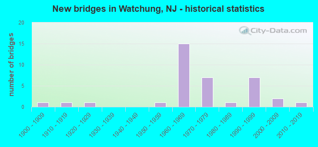
- New bridges - historical statistics
- 11900-1909
- 11910-1919
- 11920-1929
- 11950-1959
- 151960-1969
- 71970-1979
- 11980-1989
- 71990-1999
- 22000-2009
- 12010-2019
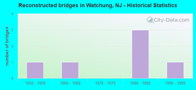
- Reconstructed bridges - Historical Statistics
- 11950-1959
- 11960-1969
- 01970-1979
- 31980-1989
- 11990-1999
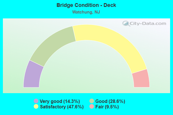
- Bridge Condition - Deck
- 14.3%Very good
- 28.6%Good
- 47.6%Satisfactory
- 9.5%Fair

- Bridge Condition - Superstructure
- 8.7%Excellent
- 13.0%Very good
- 30.4%Good
- 43.5%Satisfactory
- 4.3%Fair
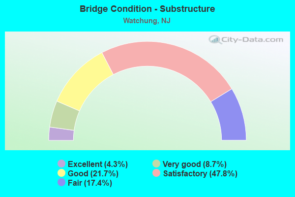
- Bridge Condition - Substructure
- 4.3%Excellent
- 8.7%Very good
- 21.7%Good
- 47.8%Satisfactory
- 17.4%Fair
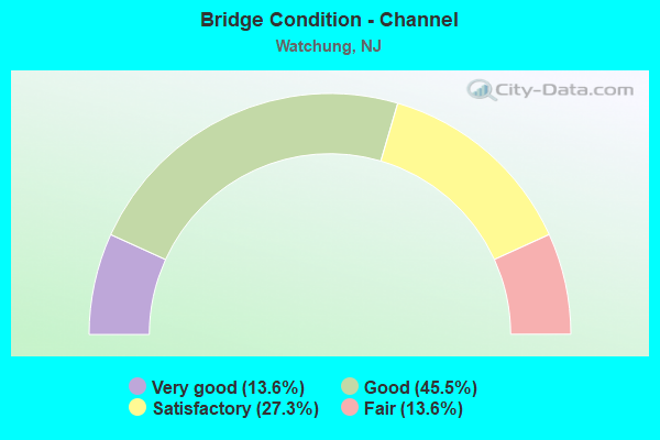
- Bridge Condition - Channel
- 13.6%Very good
- 45.5%Good
- 27.3%Satisfactory
- 13.6%Fair
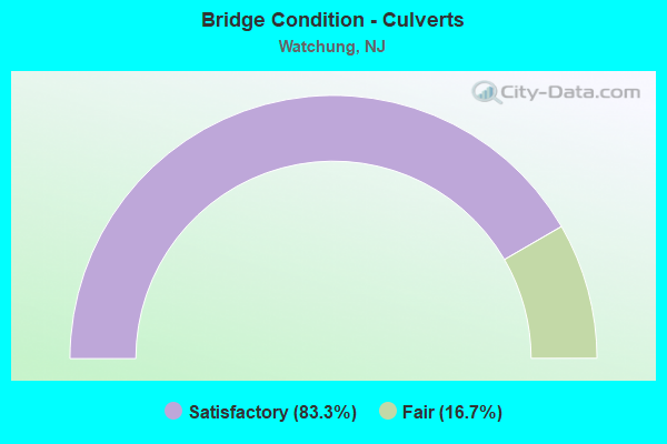
- Bridge Condition - Culverts
- 83.3%Satisfactory
- 16.7%Fair
Find on map >> Show street view
Structure Number: 1803159, Location: 10 MI EAST OF I-287 (Lat: 40.649169, Lng: -74.406569), Route carried "on" structure: US 22, Year Built: 1998, Status: Open, Structure Length: 1.89m (6.20ft), Average Daily Traffic: 53,200 (year 2021), Truck Traffic: 4%, Average Future Daily Traffic: 63,840 (year 2041), Design Load: HS 25 or greater, Features Intersected: GREEN BROOK
Minimum Vertical Clearance: 30+ m (98+ ft), Kilometerpoint: 75.655, Lanes on structure: 6, Base Highway Network: Yes, Owner: State Highway Agency, Approaching Roadway Width: 30.5m (100.1ft), Skew: 30 degrees, Material/Design: Prestressed concrete, Design/Construction: Box Beam or Girders - Multiple, Number Of Spans In Main Unit: 1, Length of Maximum Span: 17.4m (57.1ft), Curb or Sidewalk Widths: Left: 0.0m, Right: 1.8m (5.9ft), Curb-To-Curb Width: 30.6m (100.4ft), Out-to-Out Width: 34.0m (111.5ft)
Condition: Deck: Satisfactory, Superstructure: Good, Substructure: Good, Channel: Fair, Operating Rating: 81.6 metric tons, Method Used To Determine Operating Rating: Load Factor (LF), Inventory Rating: 49.0 metric tons, Method Used To Determine Inventory Rating: Load Factor (LF), Structural Evaluation: Better than present minimum criteria, Deck Geometry: Superior to present desirable criteria, Waterway Adequacy: Superior to present desirable criteria, Approach Roadway Alignment: Better than present minimum criteria, Designated Inspection Frequency: Every 24 months, Inspection Date: October 2021, Deck Structure Type: Concrete Cast-file-Place, Wearing Surface/Protective System: Wearing Surface: Monolithic Concrete, Deck Protection: Epoxy Coated Reinforcing
Find on map >> Show street view
Structure Number: 181717, Location: 0.46 MI E OF I-78 EXIT 36 (Lat: 40.647439, Lng: -74.513439), Route carried "on" structure: City street , Year Built: 1965, Year Reconstructed: 1995, Status: Open, Structure Length: 7.77m (25.49ft), Average Daily Traffic: 4,685 (year 2020), Truck Traffic: 3%, Average Future Daily Traffic: 5,715 (year 2040), Design Load: HS 20+Mod, Features Intersected: I-78, Facility Carried by Structure: MOUNTAIN AVENUE
Minimum Vertical Clearance: 30+ m (98+ ft), Kilometerpoint: 0.660, Lanes on structure: 2, Lanes under structure: 6, Owner: State Highway Agency, Approaching Roadway Width: 8.9m (29.2ft), Skew: 2 degrees, Material/Design: Prestressed concrete, Design/Construction: Stringer/Multi-beam, Number Of Spans In Main Unit: 4, Length of Maximum Span: 27.4m (89.9ft), Curb or Sidewalk Widths: Left: 1.8m (5.9ft), Right: 1.8m (5.9ft), Curb-To-Curb Width: 8.9m (29.2ft), Out-to-Out Width: 13.4m (44.0ft)
Condition: Deck: Good, Superstructure: Satisfactory, Substructure: Satisfactory, Operating Rating: 83.5 metric tons, Method Used To Determine Operating Rating: Load Factor (LF), Inventory Rating: 34.5 metric tons, Method Used To Determine Inventory Rating: Load Factor (LF), Structural Evaluation: Equal to present minimum criteria, Deck Geometry: Meets minimum limits, Underclear: High priority of corrective action, Approach Roadway Alignment: Equal to present minimum criteria, Length Of Structure Improvement: 7.77m (25.49ft), Designated Inspection Frequency: Every 24 months, Inspection Date: August 2020, Bridge Improvement Cost: $2,650,000, Roadway Improvement Cost: $250,000, Total Project Cost: $3,508,000 ( Estimate for 2020), Deck Structure Type: Concrete Cast-file-Place, Wearing Surface/Protective System: Wearing Surface: Latex Concrete
Find on map >> Show street view
Structure Number: 1817171, Location: 1.1 MI E OF I-78 EXIT 36 (Lat: 40.646861, Lng: -74.500831), Route carried "on" structure: Interstate 78, Year Built: 1965, Status: Open, Structure Length: 0.79m (2.59ft), Average Daily Traffic: 101,522 (year 2020), Truck Traffic: 9%, Average Future Daily Traffic: 121,826 (year 2040), Design Load: HS 20+Mod, Features Intersected: Cory's Brook
Minimum Vertical Clearance: 30+ m (98+ ft), Kilometerpoint: 61.976, Lanes on structure: 6, Base Highway Network: Yes, Owner: State Highway Agency, Approaching Roadway Width: 31.1m (102.0ft), Skew: 10 degrees, Material/Design: Concrete, Design/Construction: Culvert, Number Of Spans In Main Unit: 2, Length of Maximum Span: 3.7m (12.1ft)
Condition: Channel: Very good, Culverts: Satisfactory, Operating Rating: 89.8 metric tons, Method Used To Determine Operating Rating: Assigned rating based on Load Factor Design (LFD) reported in metric tons, Inventory Rating: 89.8 metric tons, Method Used To Determine Inventory Rating: Assigned rating based on Load Factor Design (LFD) reported in metric tons, Structural Evaluation: Equal to present minimum criteria, Waterway Adequacy: Superior to present desirable criteria, Approach Roadway Alignment: Better than present minimum criteria, Designated Inspection Frequency: Every 24 months, Inspection Date: April 2020
Find on map >> Show street view
Structure Number: 1817172, Location: 8 MI EAST OF I-287 (Lat: 40.646939, Lng: -74.497219), Route carried "on" structure: Other road , Year Built: 1965, Status: Open, Structure Length: 7.53m (24.70ft), Average Daily Traffic: 2,795 (year 2021), Truck Traffic: 1%, Average Future Daily Traffic: 3,350 (year 2041), Design Load: HS 20, Features Intersected: Route I-78, Facility Carried by Structure: Saw Mill Road
Minimum Vertical Clearance: 30+ m (98+ ft), Kilometerpoint: 0.000, Lanes on structure: 2, Lanes under structure: 6, Owner: State Highway Agency, Approaching Roadway Width: 9.1m (29.9ft), Skew: 1 degrees, Material/Design: Prestressed concrete, Design/Construction: Stringer/Multi-beam, Number Of Spans In Main Unit: 4, Length of Maximum Span: 28.7m (94.2ft), Curb or Sidewalk Widths: Left: 1.8m (5.9ft), Right: 1.8m (5.9ft), Curb-To-Curb Width: 9.1m (29.9ft), Out-to-Out Width: 13.6m (44.6ft)
Condition: Deck: Good, Superstructure: Satisfactory, Substructure: Satisfactory, Operating Rating: 84.4 metric tons, Method Used To Determine Operating Rating: Load Factor (LF), Inventory Rating: 35.4 metric tons, Method Used To Determine Inventory Rating: Load Factor (LF), Structural Evaluation: Equal to present minimum criteria, Deck Geometry: Meets minimum limits, Underclear: High priority of corrective action, Approach Roadway Alignment: Equal to present minimum criteria, Length Of Structure Improvement: 7.53m (24.70ft), Designated Inspection Frequency: Every 24 months, Inspection Date: Febuary 2021, Bridge Improvement Cost: $1,530,000, Roadway Improvement Cost: $170,000, Total Project Cost: $2,100,000 ( Estimate for 2021), Deck Structure Type: Concrete Cast-file-Place, Wearing Surface/Protective System: Wearing Surface: Monolithic Concrete
Find on map >> Show street view
Structure Number: 1817173, Location: 8.2 MI EAST OF I-287 (Lat: 40.648131, Lng: -74.491600), Route carried "on" structure: Other road 78, Year Built: 1965, Year Reconstructed: 1993, Status: Open, Structure Length: 6.52m (21.39ft), Average Daily Traffic: 6,622 (year 2019), Truck Traffic: 1%, Average Future Daily Traffic: 9,100 (year 2039), Design Load: HS 20+Mod, Features Intersected: ROUTE I78, Facility Carried by Structure: OLD STIRLING ROAD
Minimum Vertical Clearance: 30+ m (98+ ft), Kilometerpoint: 0.901, Lanes on structure: 2, Lanes under structure: 6, Owner: State Highway Agency, Approaching Roadway Width: 9.1m (29.9ft), Skew: 1 degrees, Material/Design: Prestressed concrete, Design/Construction: Stringer/Multi-beam, Number Of Spans In Main Unit: 3, Length of Maximum Span: 25.6m (84.0ft), Curb or Sidewalk Widths: Left: 1.8m (5.9ft), Right: 1.8m (5.9ft), Curb-To-Curb Width: 9.1m (29.9ft), Out-to-Out Width: 13.6m (44.6ft)
Condition: Deck: Satisfactory, Superstructure: Satisfactory, Substructure: Satisfactory, Operating Rating: 71.7 metric tons, Method Used To Determine Operating Rating: Load Factor (LF), Inventory Rating: 30.8 metric tons, Method Used To Determine Inventory Rating: Load Factor (LF), Structural Evaluation: Equal to present minimum criteria, Deck Geometry: Meets minimum limits, Underclear: High priority of corrective action, Approach Roadway Alignment: Equal to present desirable criteria, Length Of Structure Improvement: 6.49m (21.29ft), Designated Inspection Frequency: Every 24 months, Inspection Date: March 2021, Bridge Improvement Cost: $1,217,000, Roadway Improvement Cost: $150,000, Total Project Cost: $1,676,000 ( Estimate for 2019), Deck Structure Type: Concrete Cast-file-Place, Wearing Surface/Protective System: Wearing Surface: Latex Concrete
Find on map >> Show street view
Structure Number: 1817174, Location: 2.36 MI E OF 287 EXIT 36 (Lat: 40.649111, Lng: -74.477750), Route carried "on" structure: County highway 653, Year Built: 1970, Status: Open, Structure Length: 6.31m (20.70ft), Average Daily Traffic: 9,650 (year 2020), Truck Traffic: 4%, Average Future Daily Traffic: 11,600 (year 2040), Design Load: HS 20+Mod, Features Intersected: I-78, Facility Carried by Structure: STIRLING ROAD
Minimum Vertical Clearance: 30+ m (98+ ft), Kilometerpoint: 2.945, Lanes on structure: 2, Lanes under structure: 6, Owner: State Highway Agency, Approaching Roadway Width: 12.2m (40.0ft), Material/Design: Prestressed concrete, Design/Construction: Stringer/Multi-beam, Number Of Spans In Main Unit: 3, Length of Maximum Span: 24.7m (81.0ft), Curb or Sidewalk Widths: Left: 1.8m (5.9ft), Right: 1.8m (5.9ft), Curb-To-Curb Width: 9.1m (29.9ft), Out-to-Out Width: 13.4m (44.0ft)
Condition: Deck: Fair, Superstructure: Satisfactory, Substructure: Satisfactory, Operating Rating: 89.8 metric tons, Method Used To Determine Operating Rating: Load Factor (LF), Inventory Rating: 44.5 metric tons, Method Used To Determine Inventory Rating: Load Factor (LF), Structural Evaluation: Equal to present minimum criteria, Deck Geometry: Meets minimum limits, Underclear: High priority of corrective action, Approach Roadway Alignment: Equal to present desirable criteria, Length Of Structure Improvement: 1.65m (5.41ft), Designated Inspection Frequency: Every 24 months, Inspection Date: July 2020, Roadway Improvement Cost: $220,000, Total Project Cost: $300,000 ( Estimate for 2020), Deck Structure Type: Concrete Cast-file-Place
Find on map >> Show street view
Structure Number: 1817175, Location: 9.5 MI EAST OF I-287 (Lat: 40.650500, Lng: -74.465550), Route carried "on" structure: City street , Year Built: 1970, Status: Open, Structure Length: 5.91m (19.39ft), Average Daily Traffic: 1,107 (year 2021), Truck Traffic: 1%, Average Future Daily Traffic: 1,519 (year 2041), Design Load: HS 20+Mod, Features Intersected: ROUTE INTERSTATE 78, Facility Carried by Structure: VALLEY VIEW ROAD
Minimum Vertical Clearance: 30+ m (98+ ft), Kilometerpoint: 0.000, Lanes on structure: 2, Lanes under structure: 6, Owner: State Highway Agency, Approaching Roadway Width: 9.1m (29.9ft), Material/Design: Prestressed concrete, Design/Construction: Stringer/Multi-beam, Number Of Spans In Main Unit: 2, Length of Maximum Span: 28.7m (94.2ft), Curb or Sidewalk Widths: Left: 1.8m (5.9ft), Right: 1.8m (5.9ft), Curb-To-Curb Width: 9.1m (29.9ft), Out-to-Out Width: 13.6m (44.6ft)
Condition: Deck: Satisfactory, Superstructure: Satisfactory, Substructure: Satisfactory, Operating Rating: 77.1 metric tons, Method Used To Determine Operating Rating: Load Factor (LF), Inventory Rating: 27.2 metric tons, Method Used To Determine Inventory Rating: Load Factor (LF), Structural Evaluation: Equal to present minimum criteria, Deck Geometry: Somewhat better than minimum adequacy, Underclear: High priority of corrective action, Approach Roadway Alignment: Equal to present desirable criteria, Length Of Structure Improvement: 6.10m (20.01ft), Designated Inspection Frequency: Every 24 months, Inspection Date: March 2021, Bridge Improvement Cost: $877,000, Roadway Improvement Cost: $88,000, Total Project Cost: $1,140,000 ( Estimate for 2021), Deck Structure Type: Concrete Cast-file-Place, Wearing Surface/Protective System: Wearing Surface: Monolithic Concrete
Find on map >> Show street view
Structure Number: 1817177, Location: 3.59 MI E OF I-78 EXT 36 (Lat: 40.651669, Lng: -74.455000), Route carried "on" structure: County highway 531, Year Built: 1966, Year Reconstructed: 1986, Status: Open, Structure Length: 7.47m (24.51ft), Average Daily Traffic: 16,962 (year 2021), Truck Traffic: 4%, Average Future Daily Traffic: 20,717 (year 2041), Design Load: HS 20+Mod, Features Intersected: I-78
Minimum Vertical Clearance: 30+ m (98+ ft), Kilometerpoint: 19.119, Lanes on structure: 4, Lanes under structure: 8, Owner: State Highway Agency, Approaching Roadway Width: 15.8m (51.8ft), Skew: 20 degrees, Material/Design: Prestressed concrete, Design/Construction: Stringer/Multi-beam, Number Of Spans In Main Unit: 4, Length of Maximum Span: 28.3m (92.8ft), Curb or Sidewalk Widths: Left: 1.8m (5.9ft), Right: 1.8m (5.9ft), Curb-To-Curb Width: 15.8m (51.8ft), Out-to-Out Width: 21.5m (70.5ft)
Condition: Deck: Satisfactory, Superstructure: Satisfactory, Substructure: Fair, Inventory Rating: 32.7 metric tons, Method Used To Determine Inventory Rating: Allowable Stress (AS), Structural Evaluation: Somewhat better than minimum adequacy, Deck Geometry: Meets minimum limits, Underclear: High priority of corrective action, Approach Roadway Alignment: Equal to present desirable criteria, Length Of Structure Improvement: 7.50m (24.61ft), Designated Inspection Frequency: Every 24 months, Inspection Date: Febuary 2021, Bridge Improvement Cost: $1,075,000, Roadway Improvement Cost: $175,000, Total Project Cost: $1,500,000 ( Estimate for 2019), Deck Structure Type: Concrete Cast-file-Place, Wearing Surface/Protective System: Wearing Surface: Monolithic Concrete
Find on map >> Show street view
Structure Number: 1817178, Location: AT I-78 EXIT 41 (Lat: 40.660619, Lng: -74.434681), Route carried "on" structure: City street , Year Built: 1965, Year Reconstructed: 1994, Status: Open, Structure Length: 10.91m (35.79ft), Average Daily Traffic: 6,659 (year 2019), Truck Traffic: 1%, Average Future Daily Traffic: 8,123 (year 2039), Design Load: HS 20+Mod, Features Intersected: ROUTE I-78, Facility Carried by Structure: DRIFT ROAD
Minimum Vertical Clearance: 30+ m (98+ ft), Kilometerpoint: 0.000, Lanes on structure: 2, Lanes under structure: 6, Owner: State Highway Agency, Approaching Roadway Width: 9.1m (29.9ft), Skew: 3 degrees, Material/Design: Prestressed concrete, Design/Construction: Stringer/Multi-beam, Number Of Spans In Main Unit: 5, Length of Maximum Span: 30.8m (101.0ft), Curb or Sidewalk Widths: Left: 1.8m (5.9ft), Right: 1.8m (5.9ft), Curb-To-Curb Width: 9.1m (29.9ft), Out-to-Out Width: 13.4m (44.0ft)
Condition: Deck: Satisfactory, Superstructure: Satisfactory, Substructure: Satisfactory, Inventory Rating: 43.5 metric tons, Method Used To Determine Inventory Rating: Allowable Stress (AS), Structural Evaluation: Equal to present minimum criteria, Deck Geometry: Meets minimum limits, Underclear: Meets minimum limits, Approach Roadway Alignment: Equal to present desirable criteria, Designated Inspection Frequency: Every 24 months, Inspection Date: March 2021, Deck Structure Type: Concrete Cast-file-Place, Wearing Surface/Protective System: Wearing Surface: Latex Concrete
Find on map >> Show street view
Structure Number: 1817179, Location: 1.79 MI EAST OF CR 531 (Lat: 40.662089, Lng: -74.426331), Route carried "on" structure: Interstate 78, Year Built: 1966, Status: Open, Structure Length: 19.75m (64.80ft), Average Daily Traffic: 50,655 (year 2020), Truck Traffic: 9%, Average Future Daily Traffic: 61,810 (year 2040), Design Load: HS 20, Features Intersected: PLAINFIELD AVE&GREEN BRK
Minimum Vertical Clearance: 30.45m (99.90ft), Kilometerpoint: 68.832, Lanes on structure: 3, Lanes under structure: 4, Base Highway Network: Yes, Owner: State Highway Agency, Approaching Roadway Width: 15.8m (51.8ft), Material/Design: Steel, Design/Construction: Stringer/Multi-beam, Number Of Spans In Main Unit: 6, Length of Maximum Span: 36.0m (118.1ft), Curb or Sidewalk Widths: Left: 0.2m (0.7ft), Right: 0.2m (0.7ft), Curb-To-Curb Width: 13.7m (44.9ft), Out-to-Out Width: 15.2m (49.9ft)
Condition: Deck: Satisfactory, Superstructure: Good, Substructure: Satisfactory, Channel: Good, Operating Rating: 80.7 metric tons, Method Used To Determine Operating Rating: Load Factor (LF), Inventory Rating: 48.1 metric tons, Method Used To Determine Inventory Rating: Load Factor (LF), Structural Evaluation: Equal to present minimum criteria, Deck Geometry: Meets minimum limits, Underclear: High priority of corrective action, Waterway Adequacy: Superior to present desirable criteria, Approach Roadway Alignment: Better than present minimum criteria, Length Of Structure Improvement: 19.75m (64.80ft), Designated Inspection Frequency: Every 24 months, Inspection Date: September 2020, Roadway Improvement Cost: $401,000, Total Project Cost: $490,000 ( Estimate for 2020), Deck Structure Type: Concrete Cast-file-Place, Wearing Surface/Protective System: Wearing Surface: Bituminous
Find on map >> Show street view
Structure Number: 18K0908, Location: 0.23 MI S OF RT 527 (Lat: 40.614611, Lng: -74.494139), Route carried "on" structure: County highway 651, Year Built: 1914, Year Reconstructed: 1961, Status: Open, Structure Length: 0.70m (2.30ft), Average Daily Traffic: 16,966 (year 2021), Truck Traffic: 4%, Average Future Daily Traffic: 20,702 (year 2041), Features Intersected: EAST BR MIDDLE BROOK, Facility Carried by Structure: WARRENVILLE RD
Minimum Vertical Clearance: 30+ m (98+ ft), Kilometerpoint: 3.219, Lanes on structure: 2, Owner: County Highway Agency, Approaching Roadway Width: 9.4m (30.8ft), Skew: 1 degrees, Material/Design: Concrete, Design/Construction: Slab, Number Of Spans In Main Unit: 1, Length of Maximum Span: 6.4m (21.0ft), Curb-To-Curb Width: 9.4m (30.8ft), Out-to-Out Width: 10.1m (33.1ft)
Condition: Deck: Satisfactory, Superstructure: Satisfactory, Substructure: Satisfactory, Channel: Good, Operating Rating: 54.4 metric tons, Method Used To Determine Operating Rating: Field evaluation and documented engineering judgment, Inventory Rating: 32.7 metric tons, Method Used To Determine Inventory Rating: Field evaluation and documented engineering judgment, Structural Evaluation: Equal to present minimum criteria, Deck Geometry: High priority of corrective action, Waterway Adequacy: Equal to present minimum criteria, Approach Roadway Alignment: Equal to present desirable criteria, Length Of Structure Improvement: 0.70m (2.30ft), Designated Inspection Frequency: Every 24 months, Inspection Date: October 2021, Bridge Improvement Cost: $67,000, Roadway Improvement Cost: $7,000, Total Project Cost: $105,000 ( Estimate for 2019), Deck Structure Type: Concrete Cast-file-Place, Wearing Surface/Protective System: Wearing Surface: Bituminous
Find on map >> Show street view
Structure Number: 18K0909, Location: .05 MI S Of WASH VALLEY (Lat: 40.613150, Lng: -74.496481), Route carried "on" structure: City street , Year Built: 1963, Status: Posted for load, Structure Length: 0.70m (2.30ft), Average Daily Traffic: 1,136 (year 2021), Truck Traffic: 1%, Average Future Daily Traffic: 1,363 (year 2041), Design Load: HS 20, Features Intersected: E. BRANCH MIDDLE BROOK, Facility Carried by Structure: GREEN VALLEY DRIVE
Minimum Vertical Clearance: 30+ m (98+ ft), Kilometerpoint: 0.000, Lanes on structure: 2, Owner: County Highway Agency, Approaching Roadway Width: 8.2m (26.9ft), Material/Design: Concrete, Design/Construction: Slab, Number Of Spans In Main Unit: 1, Length of Maximum Span: 6.7m (22.0ft), Curb-To-Curb Width: 12.2m (40.0ft), Out-to-Out Width: 13.1m (43.0ft)
Condition: Deck: Good, Superstructure: Good, Substructure: Fair, Channel: Fair, Operating Rating: 41.7 metric tons, Method Used To Determine Operating Rating: Load Factor (LF), Inventory Rating: 24.5 metric tons, Method Used To Determine Inventory Rating: Load Factor (LF), Structural Evaluation: Somewhat better than minimum adequacy, Deck Geometry: Better than present minimum criteria, Waterway Adequacy: Equal to present minimum criteria, Approach Roadway Alignment: Equal to present desirable criteria, Designated Inspection Frequency: Every 24 months, Underwater Inspection Frequency: Every 48 months, Inspection Date: September 2021, Underwater Inspection Date: November 2021, Deck Structure Type: Concrete Cast-file-Place, Wearing Surface/Protective System: Wearing Surface: Bituminous
Find on map >> Show street view
Structure Number: 18K0912, Location: .05 MI SO.OF WASH VALL RD (Lat: 40.609539, Lng: -74.500000), Route carried "on" structure: City street , Year Built: 1996, Status: Open, Structure Length: 1.55m (5.09ft), Average Daily Traffic: 188 (year 2021), Truck Traffic: 1%, Average Future Daily Traffic: 226 (year 2041), Design Load: HS 20+Mod, Features Intersected: E BRANCH OF MIDDLE BROOK, Facility Carried by Structure: TOP OF WORLD WAY
Minimum Vertical Clearance: 30+ m (98+ ft), Kilometerpoint: 0.000, Lanes on structure: 2, Owner: County Highway Agency, Approaching Roadway Width: 9.2m (30.2ft), Skew: 2 degrees, Material/Design: Concrete, Design/Construction: Culvert, Number Of Spans In Main Unit: 3, Length of Maximum Span: 4.9m (16.1ft), Curb or Sidewalk Widths: Left: 1.5m (4.9ft), Right: 0.0m
Condition: Channel: Good, Culverts: Satisfactory, Inventory Rating: 71.7 metric tons, Method Used To Determine Inventory Rating: Load Factor (LF), Structural Evaluation: Equal to present minimum criteria, Waterway Adequacy: Better than present minimum criteria, Approach Roadway Alignment: Equal to present desirable criteria, Designated Inspection Frequency: Every 24 months, Inspection Date: September 2021
Find on map >> Show street view
Structure Number: 18K101, Location: 0.4 MI EAST MT BETHEL RD (Lat: 40.637939, Lng: -74.496831), Route carried "on" structure: City street , Year Built: 1976, Status: Open, Structure Length: 0.76m (2.49ft), Average Daily Traffic: 3,887 (year 2021), Truck Traffic: 1%, Average Future Daily Traffic: 4,665 (year 2041), Design Load: HS 20, Features Intersected: CORY'S BROOK, Facility Carried by Structure: REINMAN ROAD
Minimum Vertical Clearance: 30+ m (98+ ft), Kilometerpoint: 0.000, Lanes on structure: 2, Owner: County Highway Agency, Approaching Roadway Width: 9.1m (29.9ft), Material/Design: Concrete, Design/Construction: Culvert, Number Of Spans In Main Unit: 1, Length of Maximum Span: 7.6m (24.9ft)
Condition: Channel: Fair, Culverts: Satisfactory, Operating Rating: 49.0 metric tons, Method Used To Determine Operating Rating: Load Factor (LF), Inventory Rating: 29.0 metric tons, Method Used To Determine Inventory Rating: Load Factor (LF), Structural Evaluation: Equal to present minimum criteria, Waterway Adequacy: Somewhat better than minimum adequacy, Approach Roadway Alignment: Equal to present minimum criteria, Designated Inspection Frequency: Every 24 months, Inspection Date: September 2021
Find on map >> Show street view
Structure Number: 18K1102, Location: 0.2 MI W OF SAWMILL ROAD (Lat: 40.650150, Lng: -74.501631), Route carried "on" structure: City street , Year Built: 2011, Status: Open, Structure Length: 1.13m (3.71ft), Average Daily Traffic: 3,927 (year 2021), Truck Traffic: 3%, Average Future Daily Traffic: 4,792 (year 2041), Design Load: HS 20+Mod, Features Intersected: CORY'S BROOK, Facility Carried by Structure: MOUNTAIN AVENUE
Minimum Vertical Clearance: 30+ m (98+ ft), Kilometerpoint: 1.722, Lanes on structure: 2, Owner: County Highway Agency, Approaching Roadway Width: 9.8m (32.2ft), Material/Design: Steel, Design/Construction: Stringer/Multi-beam, Number Of Spans In Main Unit: 1, Length of Maximum Span: 9.8m (32.2ft), Curb-To-Curb Width: 9.8m (32.2ft), Out-to-Out Width: 11.1m (36.4ft)
Condition: Deck: Very good, Superstructure: Excellent, Substructure: Excellent, Channel: Very good, Structural Evaluation: Superior to present desirable criteria, Deck Geometry: Meets minimum limits, Waterway Adequacy: Superior to present desirable criteria, Approach Roadway Alignment: Equal to present desirable criteria, Designated Inspection Frequency: Every 24 months, Inspection Date: October 2021, Deck Structure Type: Concrete Cast-file-Place, Wearing Surface/Protective System: Wearing Surface: Monolithic Concrete, Deck Protection: Galvanized Reinforcing
Find on map >> Show street view
Structure Number: 18L1005, Location: 0.1 MI NO MOUNTAIN BLVD (Lat: 40.633200, Lng: -74.459231), Route carried "on" structure: City street , Year Built: 1976, Status: Open, Structure Length: 1.83m (6.00ft), Average Daily Traffic: 1,433 (year 2021), Truck Traffic: 1%, Average Future Daily Traffic: 1,720 (year 2041), Design Load: HS 20, Features Intersected: BROOKDALE RD & STONY BRK, Facility Carried by Structure: BROOKDALE ROAD
Minimum Vertical Clearance: 30+ m (98+ ft), Kilometerpoint: 0.000, Lanes on structure: 2, Owner: County Highway Agency, Approaching Roadway Width: 9.1m (29.9ft), Skew: 1 degrees, Material/Design: Concrete, Design/Construction: Box Beam or Girders - Multiple, Number Of Spans In Main Unit: 1, Length of Maximum Span: 17.4m (57.1ft), Curb or Sidewalk Widths: Left: 0.5m (1.6ft), Right: 1.8m (5.9ft), Curb-To-Curb Width: 9.1m (29.9ft), Out-to-Out Width: 12.2m (40.0ft)
Condition: Deck: Good, Superstructure: Good, Substructure: Good, Channel: Good, Operating Rating: 62.6 metric tons, Method Used To Determine Operating Rating: Load Factor (LF), Inventory Rating: 35.4 metric tons, Method Used To Determine Inventory Rating: Load Factor (LF), Structural Evaluation: Better than present minimum criteria, Deck Geometry: Somewhat better than minimum adequacy, Waterway Adequacy: Equal to present minimum criteria, Approach Roadway Alignment: Equal to present desirable criteria, Designated Inspection Frequency: Every 24 months, Inspection Date: September 2021, Deck Structure Type: Concrete Cast-file-Place, Wearing Surface/Protective System: Wearing Surface: Bituminous, Membrane: Preformed Fabric
Find on map >> Show street view
Structure Number: 18L1009, Location: AT RT 531 JCT (Lat: 40.636889, Lng: -74.451619), Route carried "on" structure: County highway 527, Year Built: 1908, Year Reconstructed: 1968, Status: Open, Structure Length: 1.74m (5.71ft), Average Daily Traffic: 13,704 (year 2021), Truck Traffic: 4%, Average Future Daily Traffic: 16,721 (year 2041), Features Intersected: STONY BROOK, Facility Carried by Structure: MOUNTAIN BLVd
Minimum Vertical Clearance: 30+ m (98+ ft), Kilometerpoint: 98.057, Lanes on structure: 2, Owner: County Highway Agency, Approaching Roadway Width: 12.2m (40.0ft), Material/Design: Prestressed concrete, Design/Construction: Box Beam or Girders - Multiple, Number Of Spans In Main Unit: 2, Length of Maximum Span: 8.8m (28.9ft), Curb or Sidewalk Widths: Left: 1.8m (5.9ft), Right: 1.8m (5.9ft), Curb-To-Curb Width: 12.2m (40.0ft), Out-to-Out Width: 16.6m (54.5ft)
Condition: Deck: Fair, Superstructure: Fair, Substructure: Fair, Channel: Satisfactory, Operating Rating: 45.4 metric tons, Method Used To Determine Operating Rating: Load Factor (LF), Inventory Rating: 27.2 metric tons, Method Used To Determine Inventory Rating: Load Factor (LF), Structural Evaluation: Somewhat better than minimum adequacy, Deck Geometry: Better than present minimum criteria, Waterway Adequacy: Somewhat better than minimum adequacy, Approach Roadway Alignment: Equal to present minimum criteria, Length Of Structure Improvement: 1.71m (5.61ft), Designated Inspection Frequency: Every 24 months, Inspection Date: October 2021, Bridge Improvement Cost: $443,000, Total Project Cost: $443,000 ( Estimate for 2019), Deck Structure Type: Concrete Precast Panels, Wearing Surface/Protective System: Wearing Surface: Bituminous
Find on map >> Show street view
Structure Number: 18L101, Location: RTEs 527& 531 JCT (Lat: 40.637639, Lng: -74.451269), Route carried "on" structure: County highway 527, Year Built: 2009, Status: Open, Structure Length: 0.85m (2.79ft), Average Daily Traffic: 13,704 (year 2021), Truck Traffic: 4%, Average Future Daily Traffic: 16,721 (year 2041), Design Load: HS 20+Mod, Features Intersected: EAST BR STONY BROOK, Facility Carried by Structure: WATCHUNG ROAD
Minimum Vertical Clearance: 30+ m (98+ ft), Kilometerpoint: 98.154, Lanes on structure: 2, Owner: County Highway Agency, Approaching Roadway Width: 11.6m (38.1ft), Skew: 3 degrees, Material/Design: Concrete, Design/Construction: Frame, Number Of Spans In Main Unit: 1, Length of Maximum Span: 7.6m (24.9ft), Curb or Sidewalk Widths: Left: 0.0m, Right: 1.2m (3.9ft), Curb-To-Curb Width: 11.4m (37.4ft), Out-to-Out Width: 14.1m (46.3ft)
Condition: Superstructure: Excellent, Substructure: Very good, Channel: Very good, Operating Rating: 54.4 metric tons, Method Used To Determine Operating Rating: Field evaluation and documented engineering judgment, Inventory Rating: 32.7 metric tons, Method Used To Determine Inventory Rating: Field evaluation and documented engineering judgment, Structural Evaluation: Equal to present desirable criteria, Deck Geometry: Equal to present minimum criteria, Waterway Adequacy: Equal to present desirable criteria, Approach Roadway Alignment: Equal to present minimum criteria, Designated Inspection Frequency: Every 24 months, Inspection Date: October 2021
Find on map >> Show street view
Structure Number: 18L1011, Location: AT CR 531 JCT (Lat: 40.637431, Lng: -74.452761), Route carried "on" structure: County highway 527, Year Built: 1958, Status: Open, Structure Length: 0.85m (2.79ft), Average Daily Traffic: 13,704 (year 2021), Truck Traffic: 4%, Average Future Daily Traffic: 16,721 (year 2041), Design Load: HS 20+Mod, Features Intersected: STONY BROOK, Facility Carried by Structure: MOUNTAIN BLVD.
Minimum Vertical Clearance: 30+ m (98+ ft), Kilometerpoint: 98.041, Lanes on structure: 2, Owner: County Highway Agency, Approaching Roadway Width: 13.4m (44.0ft), Skew: 2 degrees, Material/Design: Concrete, Design/Construction: Slab, Number Of Spans In Main Unit: 1, Length of Maximum Span: 8.2m (26.9ft), Curb or Sidewalk Widths: Left: 2.2m (7.2ft), Right: 2.3m (7.5ft), Curb-To-Curb Width: 11.4m (37.4ft), Out-to-Out Width: 16.2m (53.1ft)
Condition: Deck: Satisfactory, Superstructure: Satisfactory, Substructure: Fair, Channel: Satisfactory, Operating Rating: 42.6 metric tons, Method Used To Determine Operating Rating: Load Factor (LF), Inventory Rating: 25.4 metric tons, Method Used To Determine Inventory Rating: Load Factor (LF), Structural Evaluation: Somewhat better than minimum adequacy, Deck Geometry: Equal to present minimum criteria, Waterway Adequacy: Equal to present minimum criteria, Approach Roadway Alignment: Equal to present minimum criteria, Length Of Structure Improvement: 0.85m (2.79ft), Designated Inspection Frequency: Every 24 months, Inspection Date: October 2021, Bridge Improvement Cost: $370,000, Total Project Cost: $370,000 ( Estimate for 2019), Deck Structure Type: Concrete Cast-file-Place, Wearing Surface/Protective System: Wearing Surface: Monolithic Concrete
Find on map >> Show street view
Structure Number: 18L1013, Location: 0.85 MI S OF I-78 (Lat: 40.640200, Lng: -74.468000), Route carried "on" structure: County highway 653, Year Built: 2002, Status: Open, Structure Length: 2.04m (6.69ft), Average Daily Traffic: 9,749 (year 2021), Truck Traffic: 4%, Average Future Daily Traffic: 11,895 (year 2041), Design Load: HS 20+Mod, Features Intersected: STONY BROOK, Facility Carried by Structure: STIRLING ROAD
Minimum Vertical Clearance: 30+ m (98+ ft), Kilometerpoint: 1.529, Lanes on structure: 2, Owner: County Highway Agency, Approaching Roadway Width: 11.0m (36.1ft), Skew: 3 degrees, Material/Design: Steel, Design/Construction: Stringer/Multi-beam, Number Of Spans In Main Unit: 1, Length of Maximum Span: 15.2m (49.9ft), Curb or Sidewalk Widths: Left: 0.2m (0.7ft), Right: 0.2m (0.7ft), Curb-To-Curb Width: 10.8m (35.4ft), Out-to-Out Width: 11.6m (38.1ft)
Condition: Deck: Satisfactory, Superstructure: Good, Substructure: Good, Channel: Good, Inventory Rating: 78.9 metric tons, Method Used To Determine Inventory Rating: Load Factor (LF), Structural Evaluation: Better than present minimum criteria, Deck Geometry: Meets minimum limits, Waterway Adequacy: Equal to present desirable criteria, Approach Roadway Alignment: Equal to present desirable criteria, Designated Inspection Frequency: Every 24 months, Inspection Date: October 2021, Deck Structure Type: Concrete Cast-file-Place, Wearing Surface/Protective System: Wearing Surface: Monolithic Concrete, Deck Protection: Galvanized Reinforcing
Find on map >> Show street view
Structure Number: 18L1015, Location: .1 MI N OF STIRLING RD (Lat: 40.643550, Lng: -74.469069), Route carried "on" structure: City street , Year Built: 1998, Status: Open, Structure Length: 0.79m (2.59ft), Average Daily Traffic: 397 (year 2021), Truck Traffic: 1%, Average Future Daily Traffic: 484 (year 2041), Design Load: HS 20+Mod, Features Intersected: STONY BROOK, Facility Carried by Structure: STILES ROAD
Minimum Vertical Clearance: 30+ m (98+ ft), Kilometerpoint: 0.000, Lanes on structure: 2, Owner: County Highway Agency, Approaching Roadway Width: 9.1m (29.9ft), Skew: 3 degrees, Material/Design: Wood or Timber, Design/Construction: Slab, Number Of Spans In Main Unit: 1, Length of Maximum Span: 6.7m (22.0ft), Curb-To-Curb Width: 9.1m (29.9ft), Out-to-Out Width: 9.8m (32.2ft)
Condition: Deck: Good, Superstructure: Very good, Substructure: Satisfactory, Channel: Satisfactory, Inventory Rating: 89.8 metric tons, Method Used To Determine Inventory Rating: Allowable Stress (AS), Structural Evaluation: Equal to present minimum criteria, Deck Geometry: Equal to present minimum criteria, Waterway Adequacy: Better than present minimum criteria, Approach Roadway Alignment: Equal to present minimum criteria, Designated Inspection Frequency: Every 24 months, Inspection Date: September 2021, Deck Structure Type: Wood or Timber, Wearing Surface/Protective System: Wearing Surface: Bituminous, Membrane: Other
Find on map >> Show street view
Structure Number: 18L1108, Location: .25 MILE SOUTH OF RT. 512 (Lat: 40.665931, Lng: -74.482231), Route carried "on" structure: County highway 653, Year Built: 1993, Status: Open, Structure Length: 2.93m (9.61ft), Average Daily Traffic: 9,749 (year 2021), Truck Traffic: 4%, Average Future Daily Traffic: 11,895 (year 2041), Design Load: HS 20+Mod, Features Intersected: PASSAIC RIVER
Minimum Vertical Clearance: 30+ m (98+ ft), Kilometerpoint: 4.860, Lanes on structure: 2, Owner: County Highway Agency, Approaching Roadway Width: 12.2m (40.0ft), Material/Design: Prestressed concrete, Design/Construction: Slab, Number Of Spans In Main Unit: 2, Length of Maximum Span: 13.7m (44.9ft), Curb-To-Curb Width: 12.3m (40.4ft), Out-to-Out Width: 13.5m (44.3ft)
Condition: Deck: Satisfactory, Superstructure: Good, Substructure: Good, Channel: Good, Operating Rating: 46.3 metric tons, Method Used To Determine Operating Rating: Load Factor (LF), Inventory Rating: 28.1 metric tons, Method Used To Determine Inventory Rating: Load Factor (LF), Structural Evaluation: Better than present minimum criteria, Deck Geometry: Somewhat better than minimum adequacy, Waterway Adequacy: Equal to present desirable criteria, Approach Roadway Alignment: Equal to present desirable criteria, Designated Inspection Frequency: Every 24 months, Underwater Inspection Frequency: Every 48 months, Inspection Date: September 2021, Underwater Inspection Date: September 2019, Deck Structure Type: Concrete Cast-file-Place, Wearing Surface/Protective System: Wearing Surface: Monolithic Concrete, Deck Protection: Epoxy Coated Reinforcing
Find on map >> Show street view
Structure Number: 18L1109, Location: 1.56 mi N of I-78 (Lat: 40.670469, Lng: -74.464311), Route carried "on" structure: County highway 531, Year Built: 1998, Status: Open, Structure Length: 2.62m (8.60ft), Average Daily Traffic: 10,352 (year 2021), Truck Traffic: 4%, Average Future Daily Traffic: 12,632 (year 2041), Design Load: HS 20+Mod, Features Intersected: PASSAIC RIVER
Minimum Vertical Clearance: 30+ m (98+ ft), Kilometerpoint: 21.533, Lanes on structure: 2, Owner: County Highway Agency, Approaching Roadway Width: 12.2m (40.0ft), Material/Design: Steel continuous, Design/Construction: Stringer/Multi-beam, Number Of Spans In Main Unit: 2, Length of Maximum Span: 13.1m (43.0ft), Curb-To-Curb Width: 12.2m (40.0ft), Out-to-Out Width: 13.3m (43.6ft)
Condition: Deck: Very good, Superstructure: Very good, Substructure: Satisfactory, Channel: Satisfactory, Inventory Rating: 75.3 metric tons, Method Used To Determine Inventory Rating: Load Factor (LF), Structural Evaluation: Equal to present minimum criteria, Deck Geometry: Somewhat better than minimum adequacy, Waterway Adequacy: Equal to present desirable criteria, Approach Roadway Alignment: Equal to present minimum criteria, Designated Inspection Frequency: Every 24 months, Underwater Inspection Frequency: Every 48 months, Inspection Date: October 2021, Underwater Inspection Date: October 2021, Deck Structure Type: Concrete Cast-file-Place, Wearing Surface/Protective System: Wearing Surface: Monolithic Concrete, Deck Protection: Epoxy Coated Reinforcing
Find on map >> Show street view
Structure Number: 18M1021, Location: 0.1 MI NO GREENBROOK RD (Lat: 40.623800, Lng: -74.436050), Route carried "on" structure: City street , Year Built: 1975, Status: Open, Structure Length: 0.73m (2.40ft), Average Daily Traffic: 1,190 (year 2021), Truck Traffic: 1%, Average Future Daily Traffic: 1,428 (year 2041), Design Load: HS 20, Features Intersected: CRAB BROOK, Facility Carried by Structure: DUER STREET
Minimum Vertical Clearance: 30+ m (98+ ft), Kilometerpoint: 0.000, Lanes on structure: 2, Owner: County Highway Agency, Approaching Roadway Width: 9.1m (29.9ft), Skew: 3 degrees, Material/Design: Concrete, Design/Construction: Culvert, Number Of Spans In Main Unit: 1, Length of Maximum Span: 7.3m (24.0ft), Curb or Sidewalk Widths: Left: 2.7m (8.9ft), Right: 2.7m (8.9ft), Curb-To-Curb Width: 9.1m (29.9ft), Out-to-Out Width: 15.2m (49.9ft)
Condition: Channel: Good, Culverts: Satisfactory, Operating Rating: 56.2 metric tons, Method Used To Determine Operating Rating: Load Factor (LF), Inventory Rating: 33.6 metric tons, Method Used To Determine Inventory Rating: Load Factor (LF), Structural Evaluation: Equal to present minimum criteria, Deck Geometry: Somewhat better than minimum adequacy, Waterway Adequacy: Equal to present desirable criteria, Approach Roadway Alignment: Equal to present desirable criteria, Designated Inspection Frequency: Every 24 months, Inspection Date: September 2021, Deck Structure Type: Concrete Cast-file-Place, Wearing Surface/Protective System: Wearing Surface: Monolithic Concrete
Find on map >> Show street view
Structure Number: 18M1023, Location: 200 FT SE OF VALLEY ROAD (Lat: 40.644961, Lng: -74.440061), Route carried "on" structure: City street , Year Built: 1987, Status: Open, Structure Length: 1.22m (4.00ft), Average Daily Traffic: 671 (year 2021), Truck Traffic: 1%, Average Future Daily Traffic: 819 (year 2041), Design Load: HS 20+Mod, Features Intersected: EAST BR STONY BROOK, Facility Carried by Structure: JARED COURT
Minimum Vertical Clearance: 30+ m (98+ ft), Kilometerpoint: 0.000, Lanes on structure: 2, Owner: County Highway Agency, Approaching Roadway Width: 9.1m (29.9ft), Skew: 4 degrees, Material/Design: Wood or Timber, Design/Construction: Slab, Number Of Spans In Main Unit: 1, Length of Maximum Span: 11.3m (37.1ft), Curb or Sidewalk Widths: Left: 0.0m, Right: 1.5m (4.9ft), Curb-To-Curb Width: 9.3m (30.5ft), Out-to-Out Width: 11.3m (37.1ft)
Condition: Deck: Good, Superstructure: Good, Substructure: Good, Channel: Good, Operating Rating: 71.7 metric tons, Method Used To Determine Operating Rating: Allowable Stress (AS), Inventory Rating: 49.0 metric tons, Method Used To Determine Inventory Rating: Allowable Stress (AS), Structural Evaluation: Better than present minimum criteria, Deck Geometry: Equal to present minimum criteria, Waterway Adequacy: Equal to present desirable criteria, Approach Roadway Alignment: Equal to present minimum criteria, Designated Inspection Frequency: Every 24 months, Inspection Date: September 2021, Deck Structure Type: Wood or Timber, Wearing Surface/Protective System: Wearing Surface: Bituminous
Find on map >> Show street view
Structure Number: 18M1024, Location: 0.08 MI S OF RT 527 (Lat: 40.640589, Lng: -74.446181), Route carried "on" structure: City street , Year Built: 1992, Status: Open, Structure Length: 0.67m (2.20ft), Average Daily Traffic: 135 (year 2021), Truck Traffic: 1%, Average Future Daily Traffic: 164 (year 2041), Design Load: HS 20+Mod, Features Intersected: EAST BRANCH STONY BROOK, Facility Carried by Structure: KNIGHTSBRIDGE ROAD
Minimum Vertical Clearance: 30+ m (98+ ft), Kilometerpoint: 0.000, Lanes on structure: 2, Owner: County Highway Agency, Approaching Roadway Width: 9.1m (29.9ft), Skew: 2 degrees, Material/Design: Concrete, Design/Construction: Culvert, Number Of Spans In Main Unit: 1, Length of Maximum Span: 6.7m (22.0ft), Curb or Sidewalk Widths: Left: 1.2m (3.9ft), Right: 0.0m, Curb-To-Curb Width: 9.1m (29.9ft), Out-to-Out Width: 13.0m (42.7ft)
Condition: Channel: Satisfactory, Culverts: Satisfactory, Operating Rating: 82.6 metric tons, Method Used To Determine Operating Rating: Load Factor (LF), Inventory Rating: 49.0 metric tons, Method Used To Determine Inventory Rating: Load Factor (LF), Structural Evaluation: Equal to present minimum criteria, Deck Geometry: Equal to present minimum criteria, Waterway Adequacy: Superior to present desirable criteria, Approach Roadway Alignment: Better than present minimum criteria, Designated Inspection Frequency: Every 24 months, Inspection Date: September 2021, Deck Structure Type: Concrete Cast-file-Place, Wearing Surface/Protective System: Wearing Surface: Bituminous
Find on map >> Show street view
Structure Number: 18M1025, Location: 0.05 MI E OF RT 527 (Lat: 40.643011, Lng: -74.442650), Route carried "on" structure: City street , Year Built: 1998, Status: Open, Structure Length: 1.04m (3.41ft), Average Daily Traffic: 146 (year 2021), Truck Traffic: 1%, Average Future Daily Traffic: 178 (year 2041), Design Load: HS 20+Mod, Features Intersected: EAST BRANCH OF STONY BRK, Facility Carried by Structure: VALLEY DRIVE
Minimum Vertical Clearance: 30+ m (98+ ft), Kilometerpoint: 0.000, Lanes on structure: 2, Owner: County Highway Agency, Approaching Roadway Width: 8.5m (27.9ft), Material/Design: Wood or Timber, Design/Construction: Slab, Number Of Spans In Main Unit: 1, Length of Maximum Span: 9.1m (29.9ft), Curb-To-Curb Width: 9.1m (29.9ft), Out-to-Out Width: 9.8m (32.2ft)
Condition: Deck: Very good, Superstructure: Very good, Substructure: Very good, Channel: Good, Structural Evaluation: Equal to present desirable criteria, Deck Geometry: Equal to present minimum criteria, Waterway Adequacy: Better than present minimum criteria, Approach Roadway Alignment: Equal to present desirable criteria, Designated Inspection Frequency: Every 24 months, Inspection Date: September 2021, Deck Structure Type: Wood or Timber, Wearing Surface/Protective System: Wearing Surface: Bituminous, Membrane: Other
Find on map >> Show street view
Structure Number: 2001051, Location: AT SOMERSET COUNTY LINE (Lat: 40.658531, Lng: -74.419019), Route carried "on" structure: County highway 641, Year Built: 1967, Status: Open, Structure Length: 0.79m (2.59ft), Average Daily Traffic: 22,634 (year 2020), Truck Traffic: 4%, Average Future Daily Traffic: 27,622 (year 2040), Design Load: HS 20+Mod, Features Intersected: GREEN BROOK, Facility Carried by Structure: PLAINFIELD AVENUE
Minimum Vertical Clearance: 30+ m (98+ ft), Kilometerpoint: 0.000, Lanes on structure: 4, Owner: County Highway Agency, Approaching Roadway Width: 14.0m (45.9ft), Material/Design: Concrete continuous, Design/Construction: Culvert, Number Of Spans In Main Unit: 2, Length of Maximum Span: 4.0m (13.1ft), Curb-To-Curb Width: 14.0m (45.9ft), Out-to-Out Width: 15.2m (49.9ft)
Condition: Channel: Satisfactory, Culverts: Fair, Operating Rating: 32.7 metric tons, Method Used To Determine Operating Rating: Load Factor (LF), Inventory Rating: 19.1 metric tons, Method Used To Determine Inventory Rating: Load Factor (LF), Structural Evaluation: Meets minimum limits, Deck Geometry: High priority of replacement, Waterway Adequacy: Better than present minimum criteria, Approach Roadway Alignment: Equal to present minimum criteria, Length Of Structure Improvement: 0.79m (2.59ft), Designated Inspection Frequency: Every 24 months, Inspection Date: March 2020, Bridge Improvement Cost: $31,000, Roadway Improvement Cost: $30,000, Total Project Cost: $98,000 ( Estimate for 2020)
Find on map >> Show street view
Structure Number: 2016013, Location: 0.07 MI N OF US 22 (Lat: 40.655000, Lng: -74.403889), Route carried "on" structure: County highway 655, Year Built: 1920, Status: Open, Structure Length: 1.52m (4.99ft), Average Daily Traffic: 14,621 (year 2020), Truck Traffic: 4%, Average Future Daily Traffic: 17,839 (year 2040), Features Intersected: GREEN BROOK
Minimum Vertical Clearance: 30+ m (98+ ft), Kilometerpoint: 7.821, Lanes on structure: 2, Base Highway Network: Yes, Owner: County Highway Agency, Approaching Roadway Width: 6.8m (22.3ft), Skew: 3 degrees, Material/Design: Concrete, Design/Construction: Arch - Deck, Number Of Spans In Main Unit: 1, Length of Maximum Span: 15.2m (49.9ft), Curb or Sidewalk Widths: Left: 1.5m (4.9ft), Right: 1.5m (4.9ft), Curb-To-Curb Width: 6.8m (22.3ft), Out-to-Out Width: 10.6m (34.8ft)
Condition: Superstructure: Satisfactory, Substructure: Satisfactory, Channel: Good, Operating Rating: 38.1 metric tons, Method Used To Determine Operating Rating: Field evaluation and documented engineering judgment, Inventory Rating: 22.7 metric tons, Method Used To Determine Inventory Rating: Field evaluation and documented engineering judgment, Structural Evaluation: Somewhat better than minimum adequacy, Deck Geometry: High priority of replacement, Waterway Adequacy: Better than present minimum criteria, Approach Roadway Alignment: Better than present minimum criteria, Length Of Structure Improvement: 1.52m (4.99ft), Designated Inspection Frequency: Every 24 months, Inspection Date: April 2020, Bridge Improvement Cost: $153,000, Roadway Improvement Cost: $200,000, Total Project Cost: $458,000 ( Estimate for 2020)
Find on map >> Show street view
Structure Number: 181717, Location: 0.46 MI E OF I-78 EXIT 36 (Lat: 40.647439, Lng: -74.513439), Route carried "under" structure: Interstate 78, Year Built: 1965, Structure Length: 0. m, Average Daily Traffic: 99,550 (year 2020), Truck Traffic: 9%, Features Intersected: I-78, Facility Carried by Structure: MOUNTAIN AVENUE
Minimum Vertical Clearance: 4.95m (16.24ft), Kilometerpoint: 60.914, Lanes on structure: 2, Lanes under structure: 6, Material/Design: Prestressed concrete, Design/Construction: Stringer/Multi-beam, Length of Maximum Span: 27.4m (89.9ft)
Find on map >> Show street view
Structure Number: 1817172, Location: 8 MI EAST OF I-287 (Lat: 40.646939, Lng: -74.497219), Route carried "under" structure: Interstate 78, Year Built: 1965, Structure Length: 0. m, Average Daily Traffic: 102,565 (year 2021), Truck Traffic: 9%, Features Intersected: Route I-78, Facility Carried by Structure: Saw Mill Road
Minimum Vertical Clearance: 5.94m (19.49ft), Kilometerpoint: 62.298, Lanes on structure: 2, Lanes under structure: 6, Material/Design: Prestressed concrete, Design/Construction: Stringer/Multi-beam, Length of Maximum Span: 28.7m (94.2ft)
Find on map >> Show street view
Structure Number: 1817173, Location: 8.2 MI EAST OF I-287 (Lat: 40.648131, Lng: -74.491600), Route carried "under" structure: Interstate 78, Year Built: 1965, Structure Length: 0. m, Average Daily Traffic: 101,202 (year 2019), Truck Traffic: 9%, Features Intersected: ROUTE I78, Facility Carried by Structure: OLD STIRLING ROAD
Minimum Vertical Clearance: 5.08m (16.67ft), Kilometerpoint: 62.781, Lanes on structure: 2, Lanes under structure: 6, Material/Design: Prestressed concrete, Design/Construction: Stringer/Multi-beam, Length of Maximum Span: 25.6m (84.0ft)
Find on map >> Show street view
Structure Number: 1817174, Location: 2.36 MI E OF 287 EXIT 36 (Lat: 40.649111, Lng: -74.477750), Route carried "under" structure: Interstate 78, Year Built: 1970, Structure Length: 0. m, Average Daily Traffic: 101,500 (year 2020), Truck Traffic: 9%, Features Intersected: I-78, Facility Carried by Structure: STIRLING ROAD
Minimum Vertical Clearance: 5.23m (17.16ft), Kilometerpoint: 63.971, Lanes on structure: 2, Lanes under structure: 6, Material/Design: Prestressed concrete, Design/Construction: Stringer/Multi-beam, Length of Maximum Span: 24.7m (81.0ft)
Find on map >> Show street view
Structure Number: 1817175, Location: 9.5 MI EAST OF I-287 (Lat: 40.650500, Lng: -74.465550), Route carried "under" structure: Interstate 78, Year Built: 1970, Structure Length: 0. m, Average Daily Traffic: 103,226 (year 2021), Truck Traffic: 9%, Features Intersected: ROUTE INTERSTATE 78, Facility Carried by Structure: VALLEY VIEW ROAD
Minimum Vertical Clearance: 4.52m (14.83ft), Kilometerpoint: 65.017, Lanes on structure: 2, Lanes under structure: 6, Material/Design: Prestressed concrete, Design/Construction: Stringer/Multi-beam, Length of Maximum Span: 28.7m (94.2ft)
Find on map >> Show street view
Structure Number: 1817177, Location: 3.59 MI E OF I-78 EXT 36 (Lat: 40.651669, Lng: -74.455000), Route carried "under" structure: Interstate 78, Year Built: 1966, Structure Length: 0. m, Average Daily Traffic: 102,567 (year 2021), Truck Traffic: 9%, Features Intersected: I-78, Facility Carried by Structure: CR.531(HILLCR.RD)
Minimum Vertical Clearance: 4.54m (14.90ft), Kilometerpoint: 65.951, Lanes on structure: 4, Lanes under structure: 8, Material/Design: Prestressed concrete, Design/Construction: Stringer/Multi-beam, Length of Maximum Span: 28.3m (92.8ft)
Find on map >> Show street view
Structure Number: 1817178, Location: AT I-78 EXIT 41 (Lat: 40.660619, Lng: -74.434681), Route carried "under" structure: Interstate 78, Year Built: 1965, Structure Length: 0. m, Average Daily Traffic: 98,183 (year 2019), Truck Traffic: 9%, Features Intersected: ROUTE I-78, Facility Carried by Structure: DRIFT ROAD
Minimum Vertical Clearance: 5.42m (17.78ft), Kilometerpoint: 67.947, Lanes on structure: 2, Lanes under structure: 6, Material/Design: Prestressed concrete, Design/Construction: Stringer/Multi-beam, Length of Maximum Span: 30.8m (101.0ft)
Find on map >> Show street view
Structure Number: 1817179, Location: 1.79 MI EAST OF CR 531 (Lat: 40.662089, Lng: -74.426331), Route carried "under" structure: County highway 663, Year Built: 1966, Structure Length: 0. m, Average Daily Traffic: 5,660 (year 2020), Truck Traffic: 4%, Features Intersected: PLAINFIELD AVE&GREEN BRK, Facility Carried by Structure: I-78 EB
Minimum Vertical Clearance: 14.10m (46.26ft), Kilometerpoint: 0.660, Lanes on structure: 3, Lanes under structure: 4, Material/Design: Steel, Design/Construction: Stringer/Multi-beam, Length of Maximum Span: 36.0m (118.1ft)