Bridge Statistics for Watertown, South Dakota (SD)
Condition, Traffic, Stress, Structural Evaluation, Project Costs

- New bridges - historical statistics
- 11920-1929
- 31930-1939
- 21940-1949
- 11950-1959
- 31960-1969
- 211970-1979
- 41980-1989
- 31990-1999
- 22000-2009
- 52010-2019
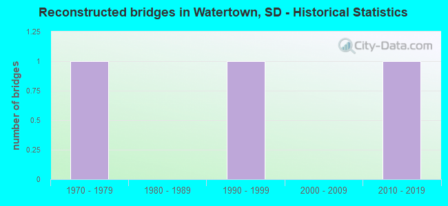
- Reconstructed bridges - Historical Statistics
- 11970-1979
- 01980-1989
- 11990-1999
- 02000-2009
- 12010-2019
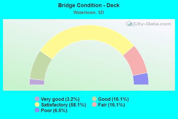
- Bridge Condition - Deck
- 3.2%Very good
- 16.1%Good
- 58.1%Satisfactory
- 16.1%Fair
- 6.5%Poor
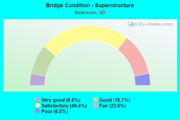
- Bridge Condition - Superstructure
- 6.5%Very good
- 16.1%Good
- 48.4%Satisfactory
- 22.6%Fair
- 6.5%Poor
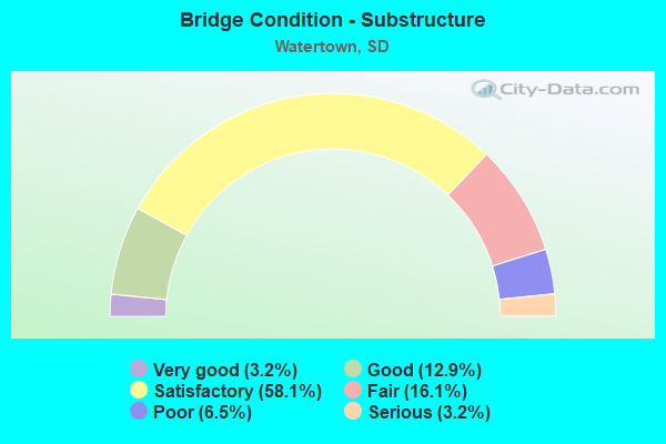
- Bridge Condition - Substructure
- 3.2%Very good
- 12.9%Good
- 58.1%Satisfactory
- 16.1%Fair
- 6.5%Poor
- 3.2%Serious

- Bridge Condition - Channel
- 21.9%Very good
- 50.0%Good
- 15.6%Satisfactory
- 6.3%Fair
- 6.3%Poor
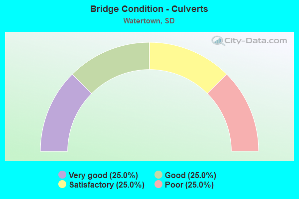
- Bridge Condition - Culverts
- 25.0%Very good
- 25.0%Good
- 25.0%Satisfactory
- 25.0%Poor
Find on map >> Show street view
Structure Number: 15140138, Location: NORTH LAKE KAMPESKA (Lat: 44.951417, Lng: -97.208075), Route carried "on" structure: Spur State highway 20, Year Built: 1931, Status: Open, Structure Length: 0.94m (3.08ft), Average Daily Traffic: 64 (year 2021), Truck Traffic: 1%, Average Future Daily Traffic: 90 (year 2041), Features Intersected: CK
Minimum Vertical Clearance: 30+ m (98+ ft), Kilometerpoint: 634.098, Lanes on structure: 2, Owner: State Highway Agency, Approaching Roadway Width: 7.3m (24.0ft), Material/Design: Concrete continuous, Design/Construction: Culvert, Number Of Spans In Main Unit: 3, Length of Maximum Span: 3.0m (9.8ft), Curb-To-Curb Width: 7.3m (24.0ft), Out-to-Out Width: 7.3m (24.0ft)
Condition: Channel: Good, Culverts: Poor, Operating Rating: 32.7 metric tons, Method Used To Determine Operating Rating: Field evaluation and documented engineering judgment, Inventory Rating: 25.1 metric tons, Method Used To Determine Inventory Rating: Field evaluation and documented engineering judgment, Structural Evaluation: Meets minimum limits, Deck Geometry: Equal to present minimum criteria, Waterway Adequacy: Equal to present desirable criteria, Approach Roadway Alignment: Better than present minimum criteria, Length Of Structure Improvement: 1.01m (3.31ft), Designated Inspection Frequency: Every 24 months, Inspection Date: May 2021, Bridge Improvement Cost: $12,000, Roadway Improvement Cost: $1,000, Total Project Cost: $14,000
Find on map >> Show street view
Structure Number: 15141139, Location: 0.3SW of Jct with SD 20 (Lat: 44.949403, Lng: -97.206439), Route carried "on" structure: City street , Year Built: 1931, Status: Open, Structure Length: 0.94m (3.08ft), Average Daily Traffic: 640 (year 2019), Truck Traffic: 10%, Average Future Daily Traffic: 868 (year 2032), Features Intersected: Creek, Facility Carried by Structure: N. Lake Drive
Minimum Vertical Clearance: 30+ m (98+ ft), Kilometerpoint: 0.000, Lanes on structure: 2, Owner: City or Municipal Highway Agency, Approaching Roadway Width: 7.3m (24.0ft), Material/Design: Concrete continuous, Design/Construction: Culvert, Number Of Spans In Main Unit: 3, Length of Maximum Span: 3.0m (9.8ft), Curb-To-Curb Width: 9.8m (32.2ft), Out-to-Out Width: 9.8m (32.2ft)
Condition: Channel: Good, Culverts: Poor, Operating Rating: 29.0 metric tons, Method Used To Determine Operating Rating: Field evaluation and documented engineering judgment, Inventory Rating: 22.7 metric tons, Method Used To Determine Inventory Rating: Field evaluation and documented engineering judgment, Structural Evaluation: Meets minimum limits, Deck Geometry: Equal to present minimum criteria, Waterway Adequacy: Equal to present desirable criteria, Approach Roadway Alignment: Equal to present desirable criteria, Length Of Structure Improvement: 2.05m (6.73ft), Designated Inspection Frequency: Every 24 months, Inspection Date: July 2021, Bridge Improvement Cost: $344,000, Roadway Improvement Cost: $34,000, Total Project Cost: $550,000 ( Estimate for 2021)
Find on map >> Show street view
Structure Number: 15156143, Location: 1.3 SE JCT SD 139 (Lat: 44.944239, Lng: -97.175256), Route carried "on" structure: State highway 20, Year Built: 1958, Status: Open, Structure Length: 5.67m (18.60ft), Average Daily Traffic: 3,572 (year 2021), Truck Traffic: 5%, Average Future Daily Traffic: 5,026 (year 2041), Design Load: H 20, Features Intersected: LAKE KAMPESKA OUTLET
Minimum Vertical Clearance: 30+ m (98+ ft), Kilometerpoint: 636.721, Lanes on structure: 4, Owner: State Highway Agency, Approaching Roadway Width: 16.8m (55.1ft), Material/Design: Concrete continuous, Design/Construction: Slab, Number Of Spans In Main Unit: 5, Length of Maximum Span: 12.2m (40.0ft), Curb or Sidewalk Widths: Left: 2.0m (6.6ft), Right: 2.0m (6.6ft), Curb-To-Curb Width: 15.9m (52.2ft), Out-to-Out Width: 19.8m (65.0ft)
Condition: Deck: Fair, Superstructure: Fair, Substructure: Satisfactory, Channel: Fair, Operating Rating: 49.7 metric tons, Method Used To Determine Operating Rating: Load Factor (LF), Inventory Rating: 29.7 metric tons, Method Used To Determine Inventory Rating: Load Factor (LF), Structural Evaluation: Somewhat better than minimum adequacy, Deck Geometry: Meets minimum limits, Waterway Adequacy: Equal to present minimum criteria, Approach Roadway Alignment: Equal to present desirable criteria, Designated Inspection Frequency: Every 24 months, Underwater Inspection Frequency: Every 60 months, Inspection Date: August 2020, Underwater Inspection Date: October 2018, Deck Structure Type: Concrete Cast-file-Place, Wearing Surface/Protective System: Wearing Surface: Epoxy Overlay, Membrane: Epoxy
Find on map >> Show street view
Structure Number: 151591, Location: 8N 3.2 W WATERTOWN (Lat: 45.006086, Lng: -97.164842), Route carried "on" structure: County highway , Year Built: 1966, Status: Open, Structure Length: 5.55m (18.21ft), Average Daily Traffic: 73 (year 2019), Truck Traffic: 2%, Average Future Daily Traffic: 73 (year 2032), Design Load: H 20, Features Intersected: BIG SIOUX RV, Facility Carried by Structure: 164 STREET
Minimum Vertical Clearance: 30+ m (98+ ft), Kilometerpoint: 0.000, Lanes on structure: 2, Owner: County Highway Agency, Approaching Roadway Width: 8.5m (27.9ft), Skew: 2 degrees, Material/Design: Steel continuous, Design/Construction: Stringer/Multi-beam, Number Of Spans In Main Unit: 3, Length of Maximum Span: 21.3m (69.9ft), Curb-To-Curb Width: 9.1m (29.9ft), Out-to-Out Width: 9.8m (32.2ft)
Condition: Deck: Good, Superstructure: Satisfactory, Substructure: Satisfactory, Channel: Poor, Operating Rating: 55.3 metric tons, Method Used To Determine Operating Rating: Load Factor (LF), Inventory Rating: 35.4 metric tons, Method Used To Determine Inventory Rating: Load Factor (LF), Structural Evaluation: Equal to present minimum criteria, Deck Geometry: Better than present minimum criteria, Waterway Adequacy: Superior to present desirable criteria, Approach Roadway Alignment: Equal to present desirable criteria, Length Of Structure Improvement: 5.55m (18.21ft), Designated Inspection Frequency: Every 24 months, Inspection Date: June 2020, Bridge Improvement Cost: $80,000, Roadway Improvement Cost: $10,000, Total Project Cost: $90,000 ( Estimate for 2020), Deck Structure Type: Concrete Cast-file-Place, Wearing Surface/Protective System: Wearing Surface: Monolithic Concrete
Find on map >> Show street view
Structure Number: 1516511, Location: 7.0N & 2.5W WATERTOWN (Lat: 44.991458, Lng: -97.155717), Route carried "on" structure: County highway , Year Built: 1987, Status: Open, Structure Length: 3.23m (10.60ft), Average Daily Traffic: 73 (year 2019), Truck Traffic: 2%, Average Future Daily Traffic: 73 (year 2032), Design Load: HS 20+Mod, Features Intersected: BIG SIOUX RV, Facility Carried by Structure: 165 STREET
Minimum Vertical Clearance: 30+ m (98+ ft), Kilometerpoint: 0.000, Lanes on structure: 2, Owner: County Highway Agency, Approaching Roadway Width: 5.2m (17.1ft), Material/Design: Concrete continuous, Design/Construction: Slab, Number Of Spans In Main Unit: 3, Length of Maximum Span: 12.2m (40.0ft), Curb-To-Curb Width: 7.9m (25.9ft), Out-to-Out Width: 8.5m (27.9ft)
Condition: Deck: Good, Superstructure: Good, Substructure: Satisfactory, Channel: Good, Operating Rating: 62.6 metric tons, Method Used To Determine Operating Rating: Load Factor (LF), Inventory Rating: 37.2 metric tons, Method Used To Determine Inventory Rating: Load Factor (LF), Structural Evaluation: Equal to present minimum criteria, Deck Geometry: Equal to present minimum criteria, Waterway Adequacy: Better than present minimum criteria, Approach Roadway Alignment: Equal to present desirable criteria, Length Of Structure Improvement: 3.23m (10.60ft), Designated Inspection Frequency: Every 24 months, Inspection Date: June 2021, Deck Structure Type: Concrete Cast-file-Place, Wearing Surface/Protective System: Wearing Surface: Integral Concrete
Find on map >> Show street view
Structure Number: 15170144, Location: 3.6N 2.0W WATERTOWN (Lat: 44.942700, Lng: -97.146336), Route carried "on" structure: County highway , Year Built: 1940, Year Reconstructed: 1975, Status: Open, Structure Length: 2.44m (8.01ft), Average Daily Traffic: 1,499 (year 2019), Truck Traffic: 2%, Average Future Daily Traffic: 1,600 (year 2035), Features Intersected: BIG SIOUX RV, Facility Carried by Structure: SIOUX CONIFER ROAD
Minimum Vertical Clearance: 30+ m (98+ ft), Kilometerpoint: 0.000, Lanes on structure: 2, Owner: County Highway Agency, Approaching Roadway Width: 7.3m (24.0ft), Material/Design: Prestressed concrete, Design/Construction: Tee Beam, Number Of Spans In Main Unit: 2, Length of Maximum Span: 11.3m (37.1ft), Curb-To-Curb Width: 8.1m (26.6ft), Out-to-Out Width: 8.2m (26.9ft)
Condition: Deck: Fair, Superstructure: Fair, Substructure: Poor, Channel: Satisfactory, Operating Rating: 32.7 metric tons, Method Used To Determine Operating Rating: Field evaluation and documented engineering judgment, Inventory Rating: 24.5 metric tons, Method Used To Determine Inventory Rating: Field evaluation and documented engineering judgment, Structural Evaluation: Meets minimum limits, Deck Geometry: Meets minimum limits, Waterway Adequacy: Better than present minimum criteria, Approach Roadway Alignment: Better than present minimum criteria, Length Of Structure Improvement: 2.44m (8.01ft), Designated Inspection Frequency: Every 24 months, Inspection Date: June 2020, Bridge Improvement Cost: $1,000,000, Roadway Improvement Cost: $200,000, Total Project Cost: $1,200,000 ( Estimate for 2020), Deck Structure Type: Concrete Precast Panels, Wearing Surface/Protective System: Wearing Surface: Bituminous
Find on map >> Show street view
Structure Number: 1517816, Location: 2 N 1.2W WATERTOWN (Lat: 44.919203, Lng: -97.129331), Route carried "on" structure: County highway , Year Built: 1974, Status: Open, Structure Length: 3.05m (10.01ft), Average Daily Traffic: 4,970 (year 2020), Truck Traffic: 2%, Average Future Daily Traffic: 6,700 (year 2040), Features Intersected: BIG SIOUX RV, Facility Carried by Structure: 14TH AVE. N, WTN.
Minimum Vertical Clearance: 30+ m (98+ ft), Kilometerpoint: 0.000, Lanes on structure: 2, Owner: County Highway Agency, Approaching Roadway Width: 9.4m (30.8ft), Material/Design: Prestressed concrete, Design/Construction: Tee Beam, Number Of Spans In Main Unit: 2, Length of Maximum Span: 15.0m (49.2ft), Curb-To-Curb Width: 9.2m (30.2ft), Out-to-Out Width: 9.4m (30.8ft)
Condition: Deck: Poor, Superstructure: Fair, Substructure: Fair, Channel: Good, Operating Rating: 24.5 metric tons, Method Used To Determine Operating Rating: Field evaluation and documented engineering judgment, Inventory Rating: 18.1 metric tons, Method Used To Determine Inventory Rating: Field evaluation and documented engineering judgment, Structural Evaluation: Somewhat better than minimum adequacy, Deck Geometry: Meets minimum limits, Waterway Adequacy: Better than present minimum criteria, Approach Roadway Alignment: Equal to present desirable criteria, Length Of Structure Improvement: 3.05m (10.01ft), Designated Inspection Frequency: Every 24 months, Inspection Date: June 2020, Bridge Improvement Cost: $1,800,000, Roadway Improvement Cost: $200,000, Total Project Cost: $2,000,000 ( Estimate for 2020), Deck Structure Type: Concrete Precast Panels, Wearing Surface/Protective System: Wearing Surface: Bituminous
Find on map >> Show street view
Structure Number: 15179165, Location: 10TH AVE - WATERTOWN (Lat: 44.911897, Lng: -97.128614), Route carried "on" structure: City street , Year Built: 1990, Status: Open, Structure Length: 1.25m (4.10ft), Average Daily Traffic: 3,089 (year 2019), Truck Traffic: 1%, Average Future Daily Traffic: 3,089 (year 2032), Design Load: HS 20+Mod, Features Intersected: BIG SIOUX RV, Facility Carried by Structure: CITY STREET
Minimum Vertical Clearance: 30+ m (98+ ft), Kilometerpoint: 0.000, Lanes on structure: 2, Owner: City or Municipal Highway Agency, Approaching Roadway Width: 6.1m (20.0ft), Skew: 2 degrees, Material/Design: Concrete continuous, Design/Construction: Culvert, Number Of Spans In Main Unit: 3, Length of Maximum Span: 4.0m (13.1ft)
Condition: Channel: Good, Culverts: Good, Operating Rating: 42.6 metric tons, Method Used To Determine Operating Rating: Load and Resistance Factor (LRFR), Inventory Rating: 32.7 metric tons, Method Used To Determine Inventory Rating: Load and Resistance Factor (LRFR), Structural Evaluation: Better than present minimum criteria, Waterway Adequacy: Better than present minimum criteria, Approach Roadway Alignment: Superior to present desirable criteria, Designated Inspection Frequency: Every 48 months, Inspection Date: June 2020, Wearing Surface/Protective System: Wearing Surface: Bituminous
Find on map >> Show street view
Structure Number: 15179183, Location: 0.2E & 0.3S OF JCT 20/212 (Lat: 44.885606, Lng: -97.127939), Route carried "on" structure: Bypass City street , Year Built: 2012, Status: Open, Structure Length: 1.62m (5.31ft), Average Daily Traffic: 100 (year 2019), Truck Traffic: 13%, Average Future Daily Traffic: 8,300 (year 2032), Design Load: HL 93, Features Intersected: PELICAN LAKE CHANNEL, Facility Carried by Structure: SOUTH CONNECTOR
Minimum Vertical Clearance: 30+ m (98+ ft), Kilometerpoint: 0.000, Lanes on structure: 2, Owner: City or Municipal Highway Agency, Approaching Roadway Width: 12.2m (40.0ft), Skew: 2 degrees, Material/Design: Concrete continuous, Design/Construction: Culvert, Number Of Spans In Main Unit: 4, Length of Maximum Span: 3.9m (12.8ft)
Condition: Channel: Good, Culverts: Very good, Operating Rating: 68.9 metric tons, Method Used To Determine Operating Rating: Load Factor (LF), Inventory Rating: 52.6 metric tons, Method Used To Determine Inventory Rating: Load Factor (LF), Structural Evaluation: Equal to present desirable criteria, Waterway Adequacy: Better than present minimum criteria, Approach Roadway Alignment: Equal to present desirable criteria, Designated Inspection Frequency: Every 48 months, Inspection Date: September 2018
Find on map >> Show street view
Structure Number: 1518117, Location: 0.3E of 10th Street NW (Lat: 44.904661, Lng: -97.125231), Route carried "on" structure: City street , Year Built: 1941, Status: Posted for load, Structure Length: 3.22m (10.56ft), Average Daily Traffic: 4,837 (year 2019), Truck Traffic: 8%, Average Future Daily Traffic: 4,837 (year 2032), Features Intersected: Big Sioux River, Facility Carried by Structure: 3rd Avenue NW
Minimum Vertical Clearance: 30+ m (98+ ft), Kilometerpoint: 0.000, Lanes on structure: 2, Owner: City or Municipal Highway Agency, Approaching Roadway Width: 12.2m (40.0ft), Material/Design: Concrete continuous, Design/Construction: Slab, Number Of Spans In Main Unit: 6, Length of Maximum Span: 5.4m (17.7ft), Curb-To-Curb Width: 12.2m (40.0ft), Out-to-Out Width: 13.2m (43.3ft)
Condition: Deck: Poor, Superstructure: Fair, Substructure: Serious, Channel: Satisfactory, Operating Rating: 18.8 metric tons, Method Used To Determine Operating Rating: Field evaluation and documented engineering judgment, Inventory Rating: 14.5 metric tons, Method Used To Determine Inventory Rating: Field evaluation and documented engineering judgment, Structural Evaluation: High priority of corrective action, Deck Geometry: Equal to present minimum criteria, Waterway Adequacy: Equal to present desirable criteria, Approach Roadway Alignment: Better than present minimum criteria, Bridge Posting: Required (Relationship of Operating Rating to Maximum Legal Load: 30.0 - 39.9% below), Length Of Structure Improvement: 4.09m (13.42ft), Designated Inspection Frequency: Every 24 months, Inspection Date: July 2021, Bridge Improvement Cost: $1,038,000, Roadway Improvement Cost: $104,000, Total Project Cost: $1,707,000 ( Estimate for 2021), Deck Structure Type: Concrete Cast-file-Place, Wearing Surface/Protective System: Wearing Surface: Bituminous
Find on map >> Show street view
Structure Number: 15181171, Location: 0.3E of 10th Street NW (Lat: 44.902697, Lng: -97.125722), Route carried "on" structure: City street , Year Built: 1935, Status: Open, Structure Length: 3.29m (10.79ft), Average Daily Traffic: 5,053 (year 2019), Truck Traffic: 8%, Average Future Daily Traffic: 5,053 (year 2032), Features Intersected: Big Sioux River, Facility Carried by Structure: W Kemp Avenue
Minimum Vertical Clearance: 30+ m (98+ ft), Kilometerpoint: 0.000, Lanes on structure: 2, Owner: City or Municipal Highway Agency, Approaching Roadway Width: 12.2m (40.0ft), Material/Design: Steel, Design/Construction: Culvert, Number Of Spans In Main Unit: 5, Length of Maximum Span: 5.9m (19.4ft), Curb or Sidewalk Widths: Left: 1.6m (5.2ft), Right: 1.6m (5.2ft)
Condition: Channel: Good, Culverts: Satisfactory, Operating Rating: 31.8 metric tons, Method Used To Determine Operating Rating: Field evaluation and documented engineering judgment, Inventory Rating: 24.5 metric tons, Method Used To Determine Inventory Rating: Field evaluation and documented engineering judgment, Structural Evaluation: Equal to present minimum criteria, Waterway Adequacy: Equal to present desirable criteria, Approach Roadway Alignment: Better than present minimum criteria, Length Of Structure Improvement: 4.17m (13.68ft), Designated Inspection Frequency: Every 24 months, Inspection Date: July 2021, Bridge Improvement Cost: $1,147,000, Roadway Improvement Cost: $115,000, Total Project Cost: $1,866,000 ( Estimate for 2021), Wearing Surface/Protective System: Wearing Surface: Bituminous
Find on map >> Show street view
Structure Number: 15181175, Location: 0.3E of 10th Street SW (Lat: 44.897397, Lng: -97.125819), Route carried "on" structure: City street , Year Built: 1977, Status: Open, Structure Length: 4.39m (14.40ft), Average Daily Traffic: 1,831 (year 2019), Truck Traffic: 1%, Average Future Daily Traffic: 1,831 (year 2032), Design Load: HS 20, Features Intersected: Big Sioux River, Facility Carried by Structure: 4th Avenue SW
Minimum Vertical Clearance: 30+ m (98+ ft), Kilometerpoint: 0.000, Lanes on structure: 2, Owner: City or Municipal Highway Agency, Approaching Roadway Width: 12.2m (40.0ft), Material/Design: Concrete continuous, Design/Construction: Slab, Number Of Spans In Main Unit: 5, Length of Maximum Span: 9.8m (32.2ft), Curb or Sidewalk Widths: Left: 1.8m (5.9ft), Right: 0.0m, Curb-To-Curb Width: 12.2m (40.0ft), Out-to-Out Width: 14.9m (48.9ft)
Condition: Deck: Satisfactory, Superstructure: Good, Substructure: Good, Channel: Very good, Operating Rating: 34.0 metric tons, Method Used To Determine Operating Rating: Field evaluation and documented engineering judgment, Inventory Rating: 24.9 metric tons, Method Used To Determine Inventory Rating: Field evaluation and documented engineering judgment, Structural Evaluation: Equal to present minimum criteria, Deck Geometry: Better than present minimum criteria, Waterway Adequacy: Equal to present desirable criteria, Approach Roadway Alignment: Equal to present desirable criteria, Length Of Structure Improvement: 5.37m (17.62ft), Designated Inspection Frequency: Every 24 months, Inspection Date: July 2021, Bridge Improvement Cost: $1,387,000, Roadway Improvement Cost: $139,000, Total Project Cost: $2,204,000 ( Estimate for 2021), Deck Structure Type: Concrete Cast-file-Place, Wearing Surface/Protective System: Wearing Surface: Integral Concrete
Find on map >> Show street view
Structure Number: 1518118, Location: 0.7 W JCT US 81 (Lat: 44.890131, Lng: -97.124356), Route carried "on" structure: US 212, Year Built: 2019, Status: Open, Structure Length: 4.72m (15.49ft), Average Daily Traffic: 15,049 (year 2021), Truck Traffic: 4%, Average Future Daily Traffic: 21,550 (year 2041), Design Load: HL 93, Features Intersected: BIG SIOUX RV
Minimum Vertical Clearance: 30+ m (98+ ft), Kilometerpoint: 606.063, Lanes on structure: 4, Base Highway Network: Yes, Owner: State Highway Agency, Approaching Roadway Width: 18.0m (59.1ft), Material/Design: Concrete continuous, Design/Construction: Slab, Number Of Spans In Main Unit: 4, Length of Maximum Span: 13.0m (42.7ft), Curb or Sidewalk Widths: Left: 1.5m (4.9ft), Right: 1.5m (4.9ft), Curb-To-Curb Width: 18.0m (59.1ft), Out-to-Out Width: 22.4m (73.5ft)
Condition: Deck: Very good, Superstructure: Very good, Substructure: Very good, Channel: Very good, Operating Rating: 48.6 metric tons, Method Used To Determine Operating Rating: Load and Resistance Factor Rating (LRFR) rating reported by rating factor(RF) method using HL-93 loadings, Inventory Rating: 37.6 metric tons, Method Used To Determine Inventory Rating: Load and Resistance Factor Rating (LRFR) rating reported by rating factor(RF) method using HL-93 loadings, Structural Evaluation: Equal to present desirable criteria, Deck Geometry: Somewhat better than minimum adequacy, Waterway Adequacy: Superior to present desirable criteria, Approach Roadway Alignment: Superior to present desirable criteria, Designated Inspection Frequency: Every 24 months, Underwater Inspection Frequency: Every 60 months, Inspection Date: June 2021, Deck Structure Type: Concrete Cast-file-Place, Wearing Surface/Protective System: Wearing Surface: Integral Concrete, Deck Protection: Epoxy Coated Reinforcing
Find on map >> Show street view
Structure Number: 15184181, Location: S. BROADWAY - WATERTOWN (Lat: 44.889256, Lng: -97.118986), Route carried "on" structure: City street , Year Built: 1962, Year Reconstructed: 2016, Status: Posted for load, Structure Length: 2.87m (9.42ft), Average Daily Traffic: 169 (year 2019), Truck Traffic: 5%, Average Future Daily Traffic: 169 (year 2032), Design Load: HL 93, Features Intersected: BIG SIOUX RV, Facility Carried by Structure: S BROADWAY WTN
Minimum Vertical Clearance: 30+ m (98+ ft), Kilometerpoint: 0.000, Lanes on structure: 2, Owner: City or Municipal Highway Agency, Approaching Roadway Width: 7.9m (25.9ft), Material/Design: Prestressed concrete, Design/Construction: Tee Beam, Number Of Spans In Main Unit: 3, Length of Maximum Span: 27.0m (88.6ft), Curb-To-Curb Width: 8.1m (26.6ft), Out-to-Out Width: 8.8m (28.9ft)
Condition: Deck: Good, Superstructure: Satisfactory, Substructure: Fair, Channel: Good, Operating Rating: 27.8 metric tons, Method Used To Determine Operating Rating: Load and Resistance Factor (LRFR), Inventory Rating: 21.4 metric tons, Method Used To Determine Inventory Rating: Load and Resistance Factor (LRFR), Structural Evaluation: Somewhat better than minimum adequacy, Deck Geometry: Somewhat better than minimum adequacy, Waterway Adequacy: Better than present minimum criteria, Approach Roadway Alignment: Better than present minimum criteria, Bridge Posting: Required (Relationship of Operating Rating to Maximum Legal Load: 10.0 - 19.9% below), Length Of Structure Improvement: 3.05m (10.01ft), Designated Inspection Frequency: Every 24 months, Inspection Date: September 2020, Deck Structure Type: Other
Find on map >> Show street view
Structure Number: 15184186, Location: 0.7E & 0.6S JCT 20/212 (Lat: 44.882081, Lng: -97.120306), Route carried "on" structure: Bypass City street , Year Built: 2012, Status: Open, Structure Length: 2.22m (7.28ft), Average Daily Traffic: 100 (year 2019), Truck Traffic: 13%, Average Future Daily Traffic: 8,300 (year 2032), Design Load: HL 93, Features Intersected: PELICAN LAKE CUTOFF CHAN, Facility Carried by Structure: SOUTH CONNECTOR
Minimum Vertical Clearance: 30+ m (98+ ft), Kilometerpoint: 0.000, Lanes on structure: 2, Owner: City or Municipal Highway Agency, Approaching Roadway Width: 12.2m (40.0ft), Material/Design: Concrete, Design/Construction: Culvert, Number Of Spans In Main Unit: 5, Length of Maximum Span: 4.3m (14.1ft)
Condition: Channel: Good, Culverts: Very good, Operating Rating: 76.2 metric tons, Method Used To Determine Operating Rating: Load Factor (LF), Inventory Rating: 59.0 metric tons, Method Used To Determine Inventory Rating: Load Factor (LF), Structural Evaluation: Equal to present desirable criteria, Waterway Adequacy: Better than present minimum criteria, Approach Roadway Alignment: Equal to present desirable criteria, Designated Inspection Frequency: Every 48 months, Inspection Date: September 2018
Find on map >> Show street view
Structure Number: 15190111, Location: 7 N JCT US 212 (Lat: 44.991272, Lng: -97.106061), Route carried "on" structure: County highway , Year Built: 1982, Status: Open, Structure Length: 1.52m (4.99ft), Average Daily Traffic: 1,425 (year 2019), Truck Traffic: 2%, Average Future Daily Traffic: 1,425 (year 2032), Design Load: HS 20, Features Intersected: CK, Facility Carried by Structure: 455 AVENUE
Minimum Vertical Clearance: 30+ m (98+ ft), Kilometerpoint: 0.000, Lanes on structure: 2, Owner: County Highway Agency, Approaching Roadway Width: 8.8m (28.9ft), Material/Design: Prestressed concrete, Design/Construction: Box Beam or Girders - Multiple, Number Of Spans In Main Unit: 2, Length of Maximum Span: 7.5m (24.6ft), Curb-To-Curb Width: 8.9m (29.2ft), Out-to-Out Width: 9.1m (29.9ft)
Condition: Deck: Satisfactory, Superstructure: Satisfactory, Substructure: Satisfactory, Channel: Good, Operating Rating: 32.7 metric tons, Method Used To Determine Operating Rating: Field evaluation and documented engineering judgment, Inventory Rating: 24.5 metric tons, Method Used To Determine Inventory Rating: Field evaluation and documented engineering judgment, Structural Evaluation: Equal to present minimum criteria, Deck Geometry: Somewhat better than minimum adequacy, Waterway Adequacy: Better than present minimum criteria, Approach Roadway Alignment: Equal to present desirable criteria, Designated Inspection Frequency: Every 24 months, Inspection Date: June 2020, Deck Structure Type: Concrete Precast Panels, Wearing Surface/Protective System: Wearing Surface: Bituminous
Find on map >> Show street view
Structure Number: 15190137, Location: 4.4 N JCT US 212 (Lat: 44.953047, Lng: -97.106769), Route carried "on" structure: County highway , Year Built: 1985, Status: Open, Structure Length: 0.73m (2.40ft), Average Daily Traffic: 1,758 (year 2019), Truck Traffic: 2%, Average Future Daily Traffic: 1,758 (year 2032), Design Load: HS 20+Mod, Features Intersected: CK, Facility Carried by Structure: 455 AVENUE
Minimum Vertical Clearance: 30+ m (98+ ft), Kilometerpoint: 0.000, Lanes on structure: 2, Owner: County Highway Agency, Approaching Roadway Width: 10.4m (34.1ft), Material/Design: Concrete continuous, Design/Construction: Culvert, Number Of Spans In Main Unit: 3, Length of Maximum Span: 3.2m (10.5ft)
Condition: Channel: Good, Culverts: Good, Operating Rating: 43.5 metric tons, Method Used To Determine Operating Rating: Field evaluation and documented engineering judgment, Inventory Rating: 32.7 metric tons, Method Used To Determine Inventory Rating: Field evaluation and documented engineering judgment, Structural Evaluation: Better than present minimum criteria, Waterway Adequacy: Better than present minimum criteria, Approach Roadway Alignment: Superior to present desirable criteria, Designated Inspection Frequency: Every 48 months, Inspection Date: June 2020, Wearing Surface/Protective System: Wearing Surface: Bituminous
Find on map >> Show street view
Structure Number: 15190186, Location: 0.7 S JCT US 212 (Lat: 44.880581, Lng: -97.108919), Route carried "on" structure: US 81, Year Built: 1966, Status: Open, Structure Length: 3.64m (11.94ft), Average Daily Traffic: 6,471 (year 2021), Truck Traffic: 7%, Average Future Daily Traffic: 9,266 (year 2041), Design Load: HS 20, Features Intersected: BIG SIOUX RV
Minimum Vertical Clearance: 30+ m (98+ ft), Kilometerpoint: 250.092, Lanes on structure: 4, Base Highway Network: Yes, Owner: State Highway Agency, Approaching Roadway Width: 25.0m (82.0ft), Skew: 3 degrees, Material/Design: Concrete continuous, Design/Construction: Slab, Number Of Spans In Main Unit: 3, Length of Maximum Span: 13.1m (43.0ft), Curb-To-Curb Width: 20.1m (65.9ft), Out-to-Out Width: 20.9m (68.6ft)
Condition: Deck: Satisfactory, Superstructure: Satisfactory, Substructure: Satisfactory, Channel: Very good, Operating Rating: 65.4 metric tons, Method Used To Determine Operating Rating: Load Factor (LF), Inventory Rating: 39.2 metric tons, Method Used To Determine Inventory Rating: Load Factor (LF), Structural Evaluation: Equal to present minimum criteria, Deck Geometry: Better than present minimum criteria, Waterway Adequacy: Equal to present desirable criteria, Approach Roadway Alignment: Equal to present desirable criteria, Designated Inspection Frequency: Every 24 months, Inspection Date: June 2021, Deck Structure Type: Concrete Cast-file-Place, Wearing Surface/Protective System: Wearing Surface: Epoxy Overlay, Membrane: Epoxy
Find on map >> Show street view
Structure Number: 1519619, Location: 1.0S & 0.5E of Watertown (Lat: 44.876542, Lng: -97.098089), Route carried "on" structure: City street , Year Built: 2010, Status: Open, Structure Length: 11.29m (37.04ft), Average Daily Traffic: 3,464 (year 2019), Truck Traffic: 3%, Average Future Daily Traffic: 5,147 (year 2037), Design Load: HL 93, Features Intersected: Big Sioux River, Facility Carried by Structure: 20th Avenue SE
Minimum Vertical Clearance: 30+ m (98+ ft), Kilometerpoint: 0.000, Lanes on structure: 2, Owner: City or Municipal Highway Agency, Approaching Roadway Width: 12.2m (40.0ft), Skew: 4 degrees, Material/Design: Prestressed concrete continuous, Design/Construction: Stringer/Multi-beam, Number Of Spans In Main Unit: 4, Length of Maximum Span: 27.7m (90.9ft), Curb-To-Curb Width: 12.2m (40.0ft), Out-to-Out Width: 13.0m (42.7ft)
Condition: Deck: Satisfactory, Superstructure: Very good, Substructure: Good, Channel: Good, Operating Rating: 35.0 metric tons, Method Used To Determine Operating Rating: Load and Resistance Factor Rating (LRFR) rating reported by rating factor(RF) method using HL-93 loadings, Inventory Rating: 26.9 metric tons, Method Used To Determine Inventory Rating: Load and Resistance Factor Rating (LRFR) rating reported by rating factor(RF) method using HL-93 loadings, Structural Evaluation: Equal to present minimum criteria, Deck Geometry: Equal to present minimum criteria, Waterway Adequacy: Superior to present desirable criteria, Approach Roadway Alignment: Better than present minimum criteria, Length Of Structure Improvement: 12.17m (39.93ft), Designated Inspection Frequency: Every 24 months, Inspection Date: July 2021, Bridge Improvement Cost: $2,633,000, Roadway Improvement Cost: $263,000, Total Project Cost: $3,979,000 ( Estimate for 2021), Deck Structure Type: Concrete Cast-file-Place, Wearing Surface/Protective System: Wearing Surface: Epoxy Overlay, Membrane: Epoxy, Deck Protection: Epoxy Coated Reinforcing
Find on map >> Show street view
Structure Number: 1520219, Location: 1.0S&1.2E WATERTOWN (Lat: 44.876517, Lng: -97.083692), Route carried "on" structure: County highway , Year Built: 2010, Status: Open, Structure Length: 3.05m (10.01ft), Average Daily Traffic: 60 (year 2019), Truck Traffic: 2%, Average Future Daily Traffic: 60 (year 2032), Design Load: HL 93, Features Intersected: WILLOW CK, Facility Carried by Structure: 20TH AVE. S, WTN.
Minimum Vertical Clearance: 30+ m (98+ ft), Kilometerpoint: 0.000, Lanes on structure: 2, Owner: City or Municipal Highway Agency, Approaching Roadway Width: 12.2m (40.0ft), Material/Design: Prestressed concrete, Design/Construction: Stringer/Multi-beam, Number Of Spans In Main Unit: 1, Length of Maximum Span: 29.3m (96.1ft), Curb-To-Curb Width: 12.2m (40.0ft), Out-to-Out Width: 13.0m (42.7ft)
Condition: Deck: Satisfactory, Superstructure: Good, Substructure: Good, Channel: Fair, Operating Rating: 43.5 metric tons, Method Used To Determine Operating Rating: Load and Resistance Factor (LRFR), Inventory Rating: 32.7 metric tons, Method Used To Determine Inventory Rating: Load and Resistance Factor (LRFR), Structural Evaluation: Better than present minimum criteria, Deck Geometry: Superior to present desirable criteria, Waterway Adequacy: Better than present minimum criteria, Approach Roadway Alignment: Equal to present desirable criteria, Designated Inspection Frequency: Every 24 months, Inspection Date: September 2020, Deck Structure Type: Concrete Cast-file-Place, Wearing Surface/Protective System: Wearing Surface: Integral Concrete, Deck Protection: Epoxy Coated Reinforcing
Find on map >> Show street view
Structure Number: 1520318, Location: 1.4 E JCT US 81 (Lat: 44.890069, Lng: -97.079639), Route carried "on" structure: US 212, Year Built: 1970, Status: Open, Structure Length: 3.84m (12.60ft), Average Daily Traffic: 11,382 (year 2021), Truck Traffic: 8%, Average Future Daily Traffic: 16,299 (year 2041), Design Load: HS 20, Features Intersected: WILLOW CK
Minimum Vertical Clearance: 30+ m (98+ ft), Kilometerpoint: 609.314, Lanes on structure: 4, Base Highway Network: Yes, Owner: State Highway Agency, Approaching Roadway Width: 15.9m (52.2ft), Material/Design: Concrete continuous, Design/Construction: Slab, Number Of Spans In Main Unit: 3, Length of Maximum Span: 13.9m (45.6ft), Curb-To-Curb Width: 16.5m (54.1ft), Out-to-Out Width: 17.3m (56.8ft)
Condition: Deck: Fair, Superstructure: Fair, Substructure: Satisfactory, Channel: Good, Operating Rating: 53.5 metric tons, Method Used To Determine Operating Rating: Load Factor (LF), Inventory Rating: 32.0 metric tons, Method Used To Determine Inventory Rating: Load Factor (LF), Structural Evaluation: Somewhat better than minimum adequacy, Deck Geometry: Meets minimum limits, Waterway Adequacy: Equal to present desirable criteria, Approach Roadway Alignment: Equal to present desirable criteria, Designated Inspection Frequency: Every 24 months, Inspection Date: June 2021, Deck Structure Type: Concrete Cast-file-Place, Wearing Surface/Protective System: Wearing Surface: Low Slump Concrete
Find on map >> Show street view
Structure Number: 15205177, Location: 1ST AVE NE (Lat: 44.893900, Lng: -97.075361), Route carried "on" structure: City street , Year Built: 2008, Status: Open, Structure Length: 3.38m (11.09ft), Average Daily Traffic: 200 (year 2019), Truck Traffic: 1%, Average Future Daily Traffic: 200 (year 2032), Design Load: HS 20+Mod, Features Intersected: WILLOW CK, Facility Carried by Structure: 1ST AVE NE
Minimum Vertical Clearance: 30+ m (98+ ft), Kilometerpoint: 0.000, Lanes on structure: 5, Owner: City or Municipal Highway Agency, Approaching Roadway Width: 19.6m (64.3ft), Skew: 3 degrees, Material/Design: Prestressed concrete, Design/Construction: Stringer/Multi-beam, Number Of Spans In Main Unit: 1, Length of Maximum Span: 31.8m (104.3ft), Curb or Sidewalk Widths: Left: 2.5m (8.2ft), Right: 0.0m, Curb-To-Curb Width: 19.6m (64.3ft), Out-to-Out Width: 23.2m (76.1ft)
Condition: Deck: Satisfactory, Superstructure: Good, Substructure: Satisfactory, Channel: Good, Operating Rating: 43.5 metric tons, Method Used To Determine Operating Rating: Load and Resistance Factor (LRFR), Inventory Rating: 32.7 metric tons, Method Used To Determine Inventory Rating: Load and Resistance Factor (LRFR), Structural Evaluation: Equal to present minimum criteria, Deck Geometry: Meets minimum limits, Waterway Adequacy: Better than present minimum criteria, Approach Roadway Alignment: Equal to present desirable criteria, Designated Inspection Frequency: Every 24 months, Inspection Date: September 2020, Deck Structure Type: Concrete Cast-file-Place, Wearing Surface/Protective System: Wearing Surface: Integral Concrete, Deck Protection: Epoxy Coated Reinforcing
Find on map >> Show street view
Structure Number: 1520918, Location: 1.9 E JCT US 81 (Lat: 44.889942, Lng: -97.065914), Route carried "on" structure: US 212, Year Built: 1970, Status: Open, Structure Length: 0.69m (2.26ft), Average Daily Traffic: 12,968 (year 2020), Truck Traffic: 11%, Average Future Daily Traffic: 17,546 (year 2040), Design Load: HS 20, Features Intersected: CK
Minimum Vertical Clearance: 30+ m (98+ ft), Kilometerpoint: 610.392, Lanes on structure: 6, Base Highway Network: Yes, Owner: State Highway Agency, Approaching Roadway Width: 31.1m (102.0ft), Skew: 23 degrees, Material/Design: Concrete continuous, Design/Construction: Culvert, Number Of Spans In Main Unit: 2, Length of Maximum Span: 3.4m (11.2ft)
Condition: Channel: Very good, Culverts: Satisfactory, Inventory Rating: 99.7 metric tons, Method Used To Determine Inventory Rating: Load Factor (LF), Structural Evaluation: Equal to present minimum criteria, Waterway Adequacy: Equal to present desirable criteria, Approach Roadway Alignment: Superior to present desirable criteria, Designated Inspection Frequency: Every 48 months, Inspection Date: September 2018
Find on map >> Show street view
Structure Number: 15214163, Location: 1.7 N US 212 INTERCH (Lat: 44.914675, Lng: -97.056531), Route carried "on" structure: Interstate 29, Year Built: 1973, Status: Open, Structure Length: 6.80m (22.31ft), Average Daily Traffic: 4,015 (year 2021), Truck Traffic: 27%, Average Future Daily Traffic: 6,111 (year 2041), Design Load: HS 20+Mod, Features Intersected: WILLOW CK
Minimum Vertical Clearance: 30+ m (98+ ft), Kilometerpoint: 289.103, Lanes on structure: 2, Base Highway Network: Yes, Owner: State Highway Agency, Approaching Roadway Width: 11.6m (38.1ft), Material/Design: Steel continuous, Design/Construction: Stringer/Multi-beam, Number Of Spans In Main Unit: 3, Length of Maximum Span: 25.9m (85.0ft), Curb-To-Curb Width: 11.6m (38.1ft), Out-to-Out Width: 12.4m (40.7ft)
Condition: Deck: Satisfactory, Superstructure: Satisfactory, Substructure: Satisfactory, Channel: Very good, Operating Rating: 49.0 metric tons, Method Used To Determine Operating Rating: Load Factor (LF), Inventory Rating: 29.3 metric tons, Method Used To Determine Inventory Rating: Load Factor (LF), Structural Evaluation: Equal to present minimum criteria, Deck Geometry: Equal to present minimum criteria, Waterway Adequacy: Superior to present desirable criteria, Approach Roadway Alignment: Equal to present desirable criteria, Designated Inspection Frequency: Every 24 months, Inspection Date: April 2021, Deck Structure Type: Concrete Cast-file-Place, Wearing Surface/Protective System: Wearing Surface: Low Slump Concrete, Membrane: Epoxy
Find on map >> Show street view
Structure Number: 1521418, Location: US 212 & I 29 INTERCHANGE (Lat: 44.890475, Lng: -97.057044), Route carried "on" structure: Interstate 29, Year Built: 1970, Status: Open, Structure Length: 9.39m (30.81ft), Average Daily Traffic: 4,015 (year 2021), Truck Traffic: 27%, Average Future Daily Traffic: 6,111 (year 2041), Design Load: HS 20+Mod, Features Intersected: US212
Minimum Vertical Clearance: 30+ m (98+ ft), Kilometerpoint: 286.399, Lanes on structure: 2, Lanes under structure: 4, Base Highway Network: Yes, Owner: State Highway Agency, Approaching Roadway Width: 11.6m (38.1ft), Material/Design: Steel continuous, Design/Construction: Stringer/Multi-beam, Number Of Spans In Main Unit: 4, Length of Maximum Span: 26.2m (86.0ft), Curb-To-Curb Width: 11.6m (38.1ft), Out-to-Out Width: 12.4m (40.7ft)
Condition: Deck: Satisfactory, Superstructure: Satisfactory, Substructure: Satisfactory, Operating Rating: 54.2 metric tons, Method Used To Determine Operating Rating: Load Factor (LF), Inventory Rating: 32.5 metric tons, Method Used To Determine Inventory Rating: Load Factor (LF), Structural Evaluation: Equal to present minimum criteria, Deck Geometry: Equal to present minimum criteria, Underclear: Superior to present desirable criteria, Approach Roadway Alignment: Equal to present desirable criteria, Designated Inspection Frequency: Every 24 months, Inspection Date: April 2021, Deck Structure Type: Concrete Cast-file-Place, Wearing Surface/Protective System: Wearing Surface: Low Slump Concrete, Membrane: Epoxy
Find on map >> Show street view
Structure Number: 152151, Location: 8 N US 212 INTERCHANGE (Lat: 45.006131, Lng: -97.054564), Route carried "on" structure: Interstate 29, Year Built: 1973, Status: Open, Structure Length: 3.84m (12.60ft), Average Daily Traffic: 4,040 (year 2021), Truck Traffic: 29%, Average Future Daily Traffic: 6,016 (year 2041), Design Load: HS 20+Mod, Features Intersected: 164 ST (FAS 6287)
Minimum Vertical Clearance: 30+ m (98+ ft), Kilometerpoint: 299.258, Lanes on structure: 2, Lanes under structure: 2, Base Highway Network: Yes, Owner: State Highway Agency, Approaching Roadway Width: 11.6m (38.1ft), Material/Design: Concrete continuous, Design/Construction: Slab, Number Of Spans In Main Unit: 3, Length of Maximum Span: 14.0m (45.9ft), Curb-To-Curb Width: 11.6m (38.1ft), Out-to-Out Width: 12.4m (40.7ft)
Condition: Deck: Satisfactory, Superstructure: Satisfactory, Substructure: Satisfactory, Operating Rating: 51.2 metric tons, Method Used To Determine Operating Rating: Load Factor (LF), Inventory Rating: 30.6 metric tons, Method Used To Determine Inventory Rating: Load Factor (LF), Structural Evaluation: Equal to present minimum criteria, Deck Geometry: Equal to present minimum criteria, Underclear: Somewhat better than minimum adequacy, Approach Roadway Alignment: Equal to present desirable criteria, Designated Inspection Frequency: Every 24 months, Inspection Date: August 2020, Deck Structure Type: Concrete Cast-file-Place, Wearing Surface/Protective System: Wearing Surface: Low Slump Concrete, Membrane: Epoxy
Find on map >> Show street view
Structure Number: 1521512, Location: 6 N US 212 INTERCH (Lat: 44.976925, Lng: -97.054339), Route carried "on" structure: County highway , Year Built: 1973, Status: Open, Structure Length: 8.99m (29.49ft), Average Daily Traffic: 73 (year 2020), Truck Traffic: 3%, Average Future Daily Traffic: 73 (year 2040), Design Load: HS 20, Features Intersected: I029, Facility Carried by Structure: 166 ST
Minimum Vertical Clearance: 30+ m (98+ ft), Kilometerpoint: 0.000, Lanes on structure: 2, Lanes under structure: 4, Owner: State Highway Agency, Approaching Roadway Width: 9.8m (32.2ft), Material/Design: Steel continuous, Design/Construction: Stringer/Multi-beam, Number Of Spans In Main Unit: 2, Number Of Approach Spans: 2, Length of Maximum Span: 34.1m (111.9ft), Curb-To-Curb Width: 9.8m (32.2ft), Out-to-Out Width: 10.6m (34.8ft)
Condition: Deck: Satisfactory, Superstructure: Satisfactory, Substructure: Satisfactory, Operating Rating: 57.4 metric tons, Method Used To Determine Operating Rating: Load Factor (LF), Inventory Rating: 34.4 metric tons, Method Used To Determine Inventory Rating: Load Factor (LF), Structural Evaluation: Equal to present minimum criteria, Deck Geometry: Equal to present desirable criteria, Underclear: Equal to present minimum criteria, Approach Roadway Alignment: Better than present minimum criteria, Designated Inspection Frequency: Every 24 months, Inspection Date: May 2021, Deck Structure Type: Concrete Cast-file-Place, Wearing Surface/Protective System: Wearing Surface: Epoxy Overlay, Membrane: Epoxy
Find on map >> Show street view
Structure Number: 1521515, Location: 3 N US 212 INTERCHANGE (Lat: 44.933728, Lng: -97.055294), Route carried "on" structure: US 81, Year Built: 1973, Status: Open, Structure Length: 8.85m (29.04ft), Average Daily Traffic: 1,606 (year 2021), Truck Traffic: 4%, Average Future Daily Traffic: 2,260 (year 2041), Design Load: HS 20, Features Intersected: I029
Minimum Vertical Clearance: 30+ m (98+ ft), Kilometerpoint: 260.134, Lanes on structure: 2, Lanes under structure: 4, Base Highway Network: Yes, Owner: State Highway Agency, Approaching Roadway Width: 10.4m (34.1ft), Material/Design: Steel continuous, Design/Construction: Stringer/Multi-beam, Number Of Spans In Main Unit: 2, Number Of Approach Spans: 2, Length of Maximum Span: 33.8m (110.9ft), Curb-To-Curb Width: 13.4m (44.0ft), Out-to-Out Width: 14.2m (46.6ft)
Condition: Deck: Satisfactory, Superstructure: Satisfactory, Substructure: Fair, Operating Rating: 56.0 metric tons, Method Used To Determine Operating Rating: Load Factor (LF), Inventory Rating: 33.5 metric tons, Method Used To Determine Inventory Rating: Load Factor (LF), Structural Evaluation: Somewhat better than minimum adequacy, Deck Geometry: Equal to present desirable criteria, Underclear: Equal to present minimum criteria, Approach Roadway Alignment: Equal to present minimum criteria, Designated Inspection Frequency: Every 24 months, Inspection Date: May 2021, Deck Structure Type: Concrete Cast-file-Place, Wearing Surface/Protective System: Wearing Surface: Low Slump Concrete, Membrane: Epoxy
Find on map >> Show street view
Structure Number: 15215163, Location: 1.7 N US 212 INTERCH (Lat: 44.914678, Lng: -97.056086), Route carried "on" structure: Interstate 29, Year Built: 1973, Status: Open, Structure Length: 6.80m (22.31ft), Average Daily Traffic: 4,015 (year 2021), Truck Traffic: 27%, Average Future Daily Traffic: 6,111 (year 2041), Design Load: HS 20+Mod, Features Intersected: WILLOW CK
Minimum Vertical Clearance: 30+ m (98+ ft), Kilometerpoint: 289.103, Lanes on structure: 2, Base Highway Network: Yes, Owner: State Highway Agency, Approaching Roadway Width: 11.6m (38.1ft), Material/Design: Steel continuous, Design/Construction: Stringer/Multi-beam, Number Of Spans In Main Unit: 3, Length of Maximum Span: 25.9m (85.0ft), Curb-To-Curb Width: 11.6m (38.1ft), Out-to-Out Width: 12.4m (40.7ft)
Condition: Deck: Satisfactory, Superstructure: Satisfactory, Substructure: Satisfactory, Channel: Very good, Operating Rating: 49.0 metric tons, Method Used To Determine Operating Rating: Load Factor (LF), Inventory Rating: 29.3 metric tons, Method Used To Determine Inventory Rating: Load Factor (LF), Structural Evaluation: Equal to present minimum criteria, Deck Geometry: Equal to present minimum criteria, Waterway Adequacy: Superior to present desirable criteria, Approach Roadway Alignment: Equal to present desirable criteria, Designated Inspection Frequency: Every 24 months, Inspection Date: April 2021, Deck Structure Type: Concrete Cast-file-Place, Wearing Surface/Protective System: Wearing Surface: Low Slump Concrete, Membrane: Epoxy
Find on map >> Show street view
Structure Number: 1521518, Location: US 212 & I 29 INTERCHANGE (Lat: 44.890461, Lng: -97.056628), Route carried "on" structure: Interstate 29, Year Built: 1971, Status: Open, Structure Length: 9.39m (30.81ft), Average Daily Traffic: 4,015 (year 2021), Truck Traffic: 27%, Average Future Daily Traffic: 6,111 (year 2041), Design Load: HS 20+Mod, Features Intersected: US212
Minimum Vertical Clearance: 30+ m (98+ ft), Kilometerpoint: 286.399, Lanes on structure: 2, Lanes under structure: 4, Base Highway Network: Yes, Owner: State Highway Agency, Approaching Roadway Width: 11.6m (38.1ft), Material/Design: Steel continuous, Design/Construction: Stringer/Multi-beam, Number Of Spans In Main Unit: 4, Length of Maximum Span: 26.2m (86.0ft), Curb-To-Curb Width: 11.6m (38.1ft), Out-to-Out Width: 12.4m (40.7ft)
Condition: Deck: Satisfactory, Superstructure: Satisfactory, Substructure: Satisfactory, Operating Rating: 54.2 metric tons, Method Used To Determine Operating Rating: Load Factor (LF), Inventory Rating: 32.5 metric tons, Method Used To Determine Inventory Rating: Load Factor (LF), Structural Evaluation: Equal to present minimum criteria, Deck Geometry: Equal to present minimum criteria, Underclear: Superior to present desirable criteria, Approach Roadway Alignment: Equal to present desirable criteria, Designated Inspection Frequency: Every 24 months, Inspection Date: April 2021, Deck Structure Type: Concrete Cast-file-Place, Wearing Surface/Protective System: Wearing Surface: Low Slump Concrete
Find on map >> Show street view
Structure Number: 1521523, Location: 5.0S 2.5E WATERTOWN (Lat: 44.818489, Lng: -97.056503), Route carried "on" structure: County highway , Year Built: 1920, Status: Posted for load, Structure Length: 2.53m (8.30ft), Average Daily Traffic: 73 (year 2019), Truck Traffic: 2%, Average Future Daily Traffic: 73 (year 2032), Features Intersected: BIG SIOUX RV, Facility Carried by Structure: 177 STREET
Minimum Vertical Clearance: 30+ m (98+ ft), Kilometerpoint: 0.000, Lanes on structure: 2, Owner: County Highway Agency, Approaching Roadway Width: 6.7m (22.0ft), Material/Design: Concrete continuous, Design/Construction: Tee Beam, Number Of Spans In Main Unit: 2, Length of Maximum Span: 12.2m (40.0ft), Curb-To-Curb Width: 5.9m (19.4ft), Out-to-Out Width: 6.6m (21.7ft)
Condition: Deck: Fair, Superstructure: Fair, Substructure: Poor, Channel: Good, Operating Rating: 18.1 metric tons, Method Used To Determine Operating Rating: Field evaluation and documented engineering judgment, Inventory Rating: 13.6 metric tons, Method Used To Determine Inventory Rating: Field evaluation and documented engineering judgment, Structural Evaluation: Meets minimum limits, Deck Geometry: Meets minimum limits, Waterway Adequacy: Better than present minimum criteria, Approach Roadway Alignment: Better than present minimum criteria, Bridge Posting: Required (Relationship of Operating Rating to Maximum Legal Load: > 39.9% below), Length Of Structure Improvement: 3.05m (10.01ft), Designated Inspection Frequency: Every 24 months, Inspection Date: June 2020, Bridge Improvement Cost: $1,000,000, Roadway Improvement Cost: $200,000, Total Project Cost: $1,200,000 ( Estimate for 2020), Deck Structure Type: Concrete Cast-file-Place, Wearing Surface/Protective System: Wearing Surface: Gravel
Find on map >> Show street view
Structure Number: 1521622, Location: 4.0S 2.6E WATERTOWN (Lat: 44.833011, Lng: -97.055950), Route carried "on" structure: County highway , Year Built: 1971, Status: Posted for load, Structure Length: 3.41m (11.19ft), Average Daily Traffic: 468 (year 2019), Truck Traffic: 2%, Average Future Daily Traffic: 500 (year 2035), Design Load: H 20, Features Intersected: BIG SIOUX RV, Facility Carried by Structure: 176 STREET
Minimum Vertical Clearance: 30+ m (98+ ft), Kilometerpoint: 0.000, Lanes on structure: 2, Owner: County Highway Agency, Approaching Roadway Width: 8.8m (28.9ft), Material/Design: Prestressed concrete, Design/Construction: Tee Beam, Number Of Spans In Main Unit: 1, Number Of Approach Spans: 2, Length of Maximum Span: 15.2m (49.9ft), Curb-To-Curb Width: 9.1m (29.9ft), Out-to-Out Width: 9.6m (31.5ft)
Condition: Deck: Satisfactory, Superstructure: Poor, Substructure: Fair, Channel: Satisfactory, Operating Rating: 33.6 metric tons, Method Used To Determine Operating Rating: Load and Resistance Factor (LRFR), Inventory Rating: 26.3 metric tons, Method Used To Determine Inventory Rating: Load and Resistance Factor (LRFR), Structural Evaluation: Meets minimum limits, Deck Geometry: Equal to present minimum criteria, Waterway Adequacy: Better than present minimum criteria, Approach Roadway Alignment: Equal to present desirable criteria, Bridge Posting: Required (Relationship of Operating Rating to Maximum Legal Load: 30.0 - 39.9% below), Length Of Structure Improvement: 3.41m (11.19ft), Designated Inspection Frequency: Every 24 months, Inspection Date: June 2020, Bridge Improvement Cost: $1,800,000, Roadway Improvement Cost: $200,000, Total Project Cost: $2,000,000 ( Estimate for 2020), Deck Structure Type: Concrete Precast Panels, Wearing Surface/Protective System: Wearing Surface: Bituminous
Find on map >> Show street view
Structure Number: 1521821, Location: 3.0S & 2.8E WATERTOWN (Lat: 44.847567, Lng: -97.049433), Route carried "on" structure: County highway , Year Built: 1986, Status: Posted for load, Structure Length: 3.09m (10.14ft), Average Daily Traffic: 41 (year 2019), Truck Traffic: 2%, Average Future Daily Traffic: 41 (year 2032), Features Intersected: BIG SIOUX RV, Facility Carried by Structure: 175 STREET
Minimum Vertical Clearance: 30+ m (98+ ft), Kilometerpoint: 0.000, Lanes on structure: 2, Owner: County Highway Agency, Approaching Roadway Width: 6.1m (20.0ft), Material/Design: Steel, Design/Construction: Stringer/Multi-beam, Number Of Spans In Main Unit: 2, Length of Maximum Span: 24.6m (80.7ft), Curb-To-Curb Width: 7.2m (23.6ft), Out-to-Out Width: 7.4m (24.3ft)
Condition: Deck: Good, Superstructure: Fair, Substructure: Fair, Channel: Satisfactory, Operating Rating: 23.6 metric tons, Method Used To Determine Operating Rating: Allowable Stress (AS), Inventory Rating: 15.4 metric tons, Method Used To Determine Inventory Rating: Allowable Stress (AS), Structural Evaluation: Meets minimum limits, Deck Geometry: Somewhat better than minimum adequacy, Waterway Adequacy: Better than present minimum criteria, Approach Roadway Alignment: Equal to present minimum criteria, Bridge Posting: Required (Relationship of Operating Rating to Maximum Legal Load: 30.0 - 39.9% below), Length Of Structure Improvement: 3.11m (10.20ft), Designated Inspection Frequency: Every 24 months, Inspection Date: June 2021, Bridge Improvement Cost: $500,000, Roadway Improvement Cost: $50,000, Total Project Cost: $550,000, Deck Structure Type: Corrugated Steel, Wearing Surface/Protective System: Wearing Surface: Gravel
Find on map >> Show street view
Structure Number: 15220161, Location: 3.0E 1.9N WATERTOWN (Lat: 44.918897, Lng: -97.045586), Route carried "on" structure: County highway , Year Built: 1996, Status: Open, Structure Length: 1.87m (6.14ft), Average Daily Traffic: 73 (year 2019), Truck Traffic: 2%, Average Future Daily Traffic: 73 (year 2032), Design Load: HS 20+Mod, Features Intersected: WILLOW CK, Facility Carried by Structure: 43RD ST., WTN.
Minimum Vertical Clearance: 30+ m (98+ ft), Kilometerpoint: 0.000, Lanes on structure: 2, Owner: County Highway Agency, Approaching Roadway Width: 5.5m (18.0ft), Material/Design: Prestressed concrete, Design/Construction: Tee Beam, Number Of Spans In Main Unit: 1, Length of Maximum Span: 18.0m (59.1ft), Curb-To-Curb Width: 10.3m (33.8ft), Out-to-Out Width: 10.8m (35.4ft)
Condition: Deck: Satisfactory, Superstructure: Satisfactory, Substructure: Satisfactory, Channel: Poor, Operating Rating: 43.5 metric tons, Method Used To Determine Operating Rating: Load Factor (LF), Inventory Rating: 32.7 metric tons, Method Used To Determine Inventory Rating: Load Factor (LF), Structural Evaluation: Equal to present minimum criteria, Deck Geometry: Superior to present desirable criteria, Waterway Adequacy: Better than present minimum criteria, Approach Roadway Alignment: Superior to present desirable criteria, Length Of Structure Improvement: 0.61m (2.00ft), Designated Inspection Frequency: Every 24 months, Inspection Date: June 2020, Bridge Improvement Cost: $10,000, Total Project Cost: $10,000 ( Estimate for 2020), Deck Structure Type: Concrete Precast Panels, Wearing Surface/Protective System: Wearing Surface: Monolithic Concrete
Find on map >> Show street view
Structure Number: 15220199, Location: 2.3 SE US 212 INTERCH (Lat: 44.863278, Lng: -97.047561), Route carried "on" structure: Interstate 29, Year Built: 1972, Status: Open, Structure Length: 5.32m (17.45ft), Average Daily Traffic: 3,975 (year 2021), Truck Traffic: 18%, Average Future Daily Traffic: 5,970 (year 2041), Design Load: HS 20+Mod, Features Intersected: 458 AVE
Minimum Vertical Clearance: 30+ m (98+ ft), Kilometerpoint: 283.132, Lanes on structure: 2, Lanes under structure: 2, Base Highway Network: Yes, Owner: State Highway Agency, Approaching Roadway Width: 11.6m (38.1ft), Skew: 4 degrees, Material/Design: Steel continuous, Design/Construction: Stringer/Multi-beam, Number Of Spans In Main Unit: 3, Length of Maximum Span: 19.8m (65.0ft), Curb-To-Curb Width: 11.6m (38.1ft), Out-to-Out Width: 12.4m (40.7ft)
Condition: Deck: Satisfactory, Superstructure: Satisfactory, Substructure: Satisfactory, Operating Rating: 53.4 metric tons, Method Used To Determine Operating Rating: Load Factor (LF), Inventory Rating: 32.0 metric tons, Method Used To Determine Inventory Rating: Load Factor (LF), Structural Evaluation: Equal to present minimum criteria, Deck Geometry: Equal to present minimum criteria, Underclear: Somewhat better than minimum adequacy, Approach Roadway Alignment: Equal to present desirable criteria, Designated Inspection Frequency: Every 24 months, Inspection Date: June 2021, Deck Structure Type: Concrete Cast-file-Place, Wearing Surface/Protective System: Wearing Surface: Low Slump Concrete
Find on map >> Show street view
Structure Number: 152202, Location: 2.3 SE US 212 INTERCH (Lat: 44.862822, Lng: -97.047544), Route carried "on" structure: Interstate 29, Year Built: 1972, Status: Open, Structure Length: 5.32m (17.45ft), Average Daily Traffic: 3,975 (year 2021), Truck Traffic: 18%, Average Future Daily Traffic: 5,970 (year 2041), Design Load: HS 20+Mod, Features Intersected: 458 AVE
Minimum Vertical Clearance: 30+ m (98+ ft), Kilometerpoint: 283.132, Lanes on structure: 2, Lanes under structure: 2, Base Highway Network: Yes, Owner: State Highway Agency, Approaching Roadway Width: 11.6m (38.1ft), Skew: 4 degrees, Material/Design: Steel continuous, Design/Construction: Stringer/Multi-beam, Number Of Spans In Main Unit: 3, Length of Maximum Span: 19.8m (65.0ft), Curb-To-Curb Width: 11.6m (38.1ft), Out-to-Out Width: 12.4m (40.7ft)
Condition: Deck: Satisfactory, Superstructure: Satisfactory, Substructure: Satisfactory, Operating Rating: 53.5 metric tons, Method Used To Determine Operating Rating: Load Factor (LF), Inventory Rating: 32.0 metric tons, Method Used To Determine Inventory Rating: Load Factor (LF), Structural Evaluation: Equal to present minimum criteria, Deck Geometry: Equal to present minimum criteria, Underclear: Equal to present minimum criteria, Approach Roadway Alignment: Equal to present desirable criteria, Designated Inspection Frequency: Every 24 months, Inspection Date: June 2021, Deck Structure Type: Concrete Cast-file-Place, Wearing Surface/Protective System: Wearing Surface: Low Slump Concrete
Find on map >> Show street view
Structure Number: 15230166, Location: 4.0E 1.4N WATERTOWN (Lat: 44.910250, Lng: -97.025011), Route carried "on" structure: County highway , Year Built: 2006, Status: Open, Structure Length: 2.32m (7.61ft), Average Daily Traffic: 100 (year 2019), Truck Traffic: 9%, Average Future Daily Traffic: 110 (year 2032), Design Load: HS 20+Mod, Features Intersected: WILLOW CK, Facility Carried by Structure: 459 AVE
Minimum Vertical Clearance: 30+ m (98+ ft), Kilometerpoint: 0.000, Lanes on structure: 2, Owner: County Highway Agency, Approaching Roadway Width: 9.8m (32.2ft), Material/Design: Prestressed concrete, Design/Construction: Tee Beam, Number Of Spans In Main Unit: 1, Length of Maximum Span: 21.9m (71.9ft), Curb-To-Curb Width: 9.0m (29.5ft), Out-to-Out Width: 9.8m (32.2ft)
Condition: Deck: Satisfactory, Superstructure: Satisfactory, Substructure: Satisfactory, Channel: Very good, Operating Rating: 43.5 metric tons, Method Used To Determine Operating Rating: Load Factor (LF), Inventory Rating: 32.7 metric tons, Method Used To Determine Inventory Rating: Load Factor (LF), Structural Evaluation: Equal to present minimum criteria, Deck Geometry: Better than present minimum criteria, Waterway Adequacy: Better than present minimum criteria, Approach Roadway Alignment: Equal to present desirable criteria, Designated Inspection Frequency: Every 24 months, Inspection Date: June 2020, Deck Structure Type: Concrete Precast Panels, Wearing Surface/Protective System: Wearing Surface: Monolithic Concrete
Find on map >> Show street view
Structure Number: 1523916, Location: 4.9E 2N WATERTOWN (Lat: 44.918817, Lng: -97.004872), Route carried "on" structure: County highway , Year Built: 1995, Status: Open, Structure Length: 2.44m (8.01ft), Average Daily Traffic: 49 (year 2019), Truck Traffic: 2%, Average Future Daily Traffic: 49 (year 2032), Design Load: HS 20+Mod, Features Intersected: WILLOW CK, Facility Carried by Structure: 170 STREET
Minimum Vertical Clearance: 30+ m (98+ ft), Kilometerpoint: 0.000, Lanes on structure: 2, Owner: County Highway Agency, Approaching Roadway Width: 6.1m (20.0ft), Material/Design: Concrete continuous, Design/Construction: Slab, Number Of Spans In Main Unit: 3, Length of Maximum Span: 9.1m (29.9ft), Curb-To-Curb Width: 9.1m (29.9ft), Out-to-Out Width: 9.4m (30.8ft)
Condition: Deck: Good, Superstructure: Good, Substructure: Good, Channel: Good, Operating Rating: 63.5 metric tons, Method Used To Determine Operating Rating: Load Factor (LF), Inventory Rating: 38.1 metric tons, Method Used To Determine Inventory Rating: Load Factor (LF), Structural Evaluation: Better than present minimum criteria, Deck Geometry: Better than present minimum criteria, Waterway Adequacy: Better than present minimum criteria, Approach Roadway Alignment: Better than present minimum criteria, Designated Inspection Frequency: Every 24 months, Inspection Date: June 2021, Deck Structure Type: Concrete Cast-file-Place, Wearing Surface/Protective System: Wearing Surface: Integral Concrete, Deck Protection: Epoxy Coated Reinforcing
Find on map >> Show street view
Structure Number: 15240155, Location: 5.0E 2.5N WATERTOWN (Lat: 44.926081, Lng: -97.004350), Route carried "on" structure: County highway , Year Built: 1973, Year Reconstructed: 2001, Status: Posted for load, Structure Length: 1.52m (4.99ft), Average Daily Traffic: 336 (year 2019), Truck Traffic: 2%, Average Future Daily Traffic: 336 (year 2017), Features Intersected: WILLOW CK, Facility Carried by Structure: 460 AVENUE
Minimum Vertical Clearance: 30+ m (98+ ft), Kilometerpoint: 0.000, Lanes on structure: 2, Owner: County Highway Agency, Approaching Roadway Width: 8.5m (27.9ft), Material/Design: Prestressed concrete, Design/Construction: Tee Beam, Number Of Spans In Main Unit: 1, Length of Maximum Span: 14.9m (48.9ft), Curb-To-Curb Width: 9.2m (30.2ft), Out-to-Out Width: 9.4m (30.8ft)
Condition: Deck: Fair, Superstructure: Poor, Substructure: Satisfactory, Channel: Satisfactory, Operating Rating: 21.8 metric tons, Method Used To Determine Operating Rating: Field evaluation and documented engineering judgment, Inventory Rating: 16.3 metric tons, Method Used To Determine Inventory Rating: Field evaluation and documented engineering judgment, Structural Evaluation: Meets minimum limits, Deck Geometry: Equal to present minimum criteria, Waterway Adequacy: Better than present minimum criteria, Approach Roadway Alignment: Equal to present desirable criteria, Bridge Posting: Required (Relationship of Operating Rating to Maximum Legal Load: 30.0 - 39.9% below), Length Of Structure Improvement: 1.52m (4.99ft), Designated Inspection Frequency: Every 24 months, Inspection Date: June 2020, Bridge Improvement Cost: $250,000, Roadway Improvement Cost: $50,000, Total Project Cost: $250,000 ( Estimate for 2020), Deck Structure Type: Concrete Precast Panels, Wearing Surface/Protective System: Wearing Surface: Monolithic Concrete
Find on map >> Show street view
Structure Number: 1521418, Location: US 212 & I 29 INTERCHANGE (Lat: 44.890475, Lng: -97.057044), Route carried "under" structure: US 212, Year Built: 1970, Structure Length: 0. m, Average Daily Traffic: 12,968 (year 2020), Truck Traffic: 11%, Features Intersected: US212, Facility Carried by Structure: I029 S
Minimum Vertical Clearance: 5.54m (18.18ft), Kilometerpoint: 611.116, Lanes on structure: 2, Lanes under structure: 4, Material/Design: Steel continuous, Design/Construction: Stringer/Multi-beam, Length of Maximum Span: 26.2m (86.0ft)
Find on map >> Show street view
Structure Number: 1521512, Location: 6 N US 212 INTERCH (Lat: 44.976925, Lng: -97.054339), Route carried "under" structure: Interstate 29, Year Built: 1973, Structure Length: 0. m, Average Daily Traffic: 7,370 (year 2020), Truck Traffic: 19%, Features Intersected: I029, Facility Carried by Structure: 166 ST
Minimum Vertical Clearance: 5.51m (18.08ft), Kilometerpoint: 296.023, Lanes on structure: 2, Lanes under structure: 4, Material/Design: Steel continuous, Design/Construction: Stringer/Multi-beam, Length of Maximum Span: 34.1m (111.9ft)