Bridge Statistics for Waxahachie, Texas (TX)
Condition, Traffic, Stress, Structural Evaluation, Project Costs
- National Bridge Inventory (NBI) Statistics
- 176Number of bridges
- 2,057ft / 627mTotal length
- $800,000Total costs
- 2,268,558Total average daily traffic
- 461,574Total average daily truck traffic
- National Bridge Inventory (NBI) Registered Bridges for Waxahachie
- No street view available for this location
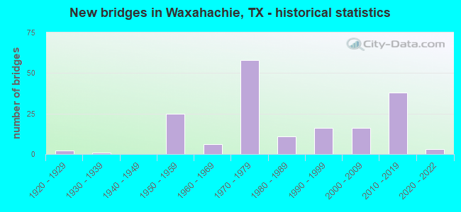
- New bridges - historical statistics
- 21920-1929
- 11930-1939
- 251950-1959
- 61960-1969
- 581970-1979
- 111980-1989
- 161990-1999
- 162000-2009
- 382010-2019
- 32020-2022
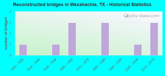
- Reconstructed bridges - Historical Statistics
- 11930-1939
- 01940-1949
- 11950-1959
- 31960-1969
- 01970-1979
- 31980-1989
- 01990-1999
- 12000-2009
- 32010-2019
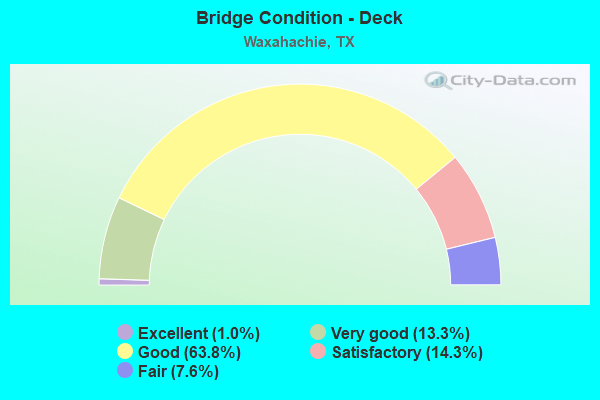
- Bridge Condition - Deck
- 1.0%Excellent
- 13.3%Very good
- 63.8%Good
- 14.3%Satisfactory
- 7.6%Fair
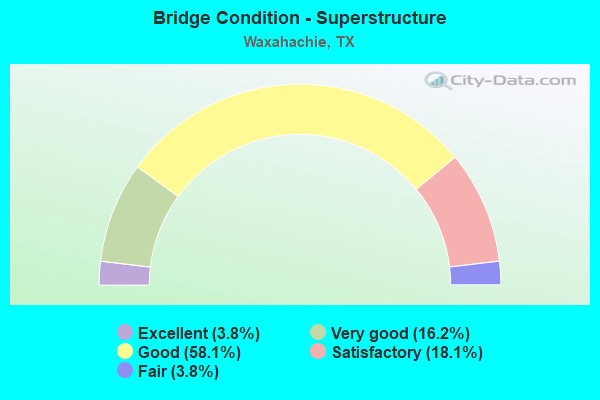
- Bridge Condition - Superstructure
- 3.8%Excellent
- 16.2%Very good
- 58.1%Good
- 18.1%Satisfactory
- 3.8%Fair
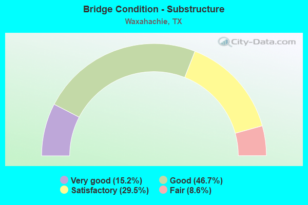
- Bridge Condition - Substructure
- 15.2%Very good
- 46.7%Good
- 29.5%Satisfactory
- 8.6%Fair
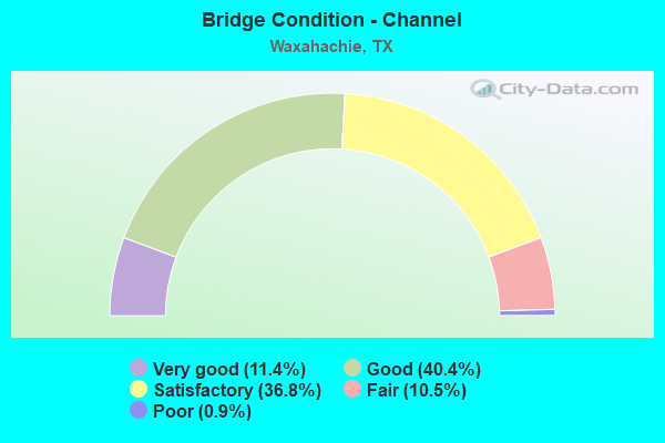
- Bridge Condition - Channel
- 11.4%Very good
- 40.4%Good
- 36.8%Satisfactory
- 10.5%Fair
- 0.9%Poor
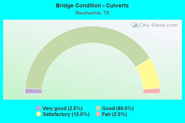
- Bridge Condition - Culverts
- 2.5%Very good
- 80.0%Good
- 15.0%Satisfactory
- 2.5%Fair
Find on map >> Show street view
Structure Number: 180570296401499, Location: DC RAMP B20 ROBINSON RD (Lat: 32.413236, Lng: -96.831425), Route carried "on" structure: Ramp Interstate 40, Year Built: 2019, Status: Open, Structure Length: 7.38m (24.21ft), Average Daily Traffic: 7,240 (year 2017), Average Future Daily Traffic: 10,140 (year 2037), Design Load: HL 93, Features Intersected: ROBINSON RD FISH CRK, Facility Carried by Structure: SH 161 SB OFF-RAMP
Minimum Vertical Clearance: 30+ m (98+ ft), Kilometerpoint: 0.000, Lanes on structure: 1, Lanes under structure: 4, Toll: On toll road, Owner: Local Toll Authority, Approaching Roadway Width: 11.6m (38.1ft), Skew: 2 degrees, Material/Design: Prestressed concrete, Design/Construction: Stringer/Multi-beam, Number Of Spans In Main Unit: 2, Length of Maximum Span: 36.9m (121.1ft), Curb-To-Curb Width: 11.0m (36.1ft), Out-to-Out Width: 11.6m (38.1ft)
Condition: Deck: Very good, Superstructure: Very good, Substructure: Very good, Channel: Satisfactory, Operating Rating: 54.4 metric tons, Method Used To Determine Operating Rating: Assigned ratings based on Load and Resistance Factor Design (LRFD) reported in metric tons, Inventory Rating: 32.7 metric tons, Method Used To Determine Inventory Rating: Assigned ratings based on Load and Resistance Factor Design (LRFD) reported in metric tons, Structural Evaluation: Equal to present desirable criteria, Deck Geometry: Superior to present desirable criteria, Underclear: High priority of corrective action, Waterway Adequacy: Superior to present desirable criteria, Approach Roadway Alignment: Equal to present desirable criteria, Designated Inspection Frequency: Every 24 months, Inspection Date: April 2021, Deck Structure Type: Concrete Precast Panels
Find on map >> Show street view
Structure Number: 180710004803132, Location: 0.1 MI N OF US 287 (Lat: 32.421222, Lng: -96.840106), Route carried "on" structure: US 77, Year Built: 1976, Status: Open, Structure Length: 1.04m (3.41ft), Average Daily Traffic: 30,363 (year 2020), Truck Traffic: 7%, Average Future Daily Traffic: 19,430 (year 2033), Features Intersected: DRAINAGE DITCH
Minimum Vertical Clearance: 30+ m (98+ ft), Kilometerpoint: 15.424, Lanes on structure: 7, Owner: State Highway Agency, Approaching Roadway Width: 24.4m (80.1ft), Material/Design: Concrete, Design/Construction: Culvert, Number Of Spans In Main Unit: 4, Length of Maximum Span: 2.4m (7.9ft)
Condition: Channel: Satisfactory, Culverts: Good, Operating Rating: 32.7 metric tons, Method Used To Determine Operating Rating: Field evaluation and documented engineering judgment, Inventory Rating: 24.5 metric tons, Method Used To Determine Inventory Rating: Field evaluation and documented engineering judgment, Structural Evaluation: Equal to present minimum criteria, Waterway Adequacy: Equal to present minimum criteria, Approach Roadway Alignment: Equal to present desirable criteria, Designated Inspection Frequency: Every 24 months, Inspection Date: September 2021
Find on map >> Show street view
Structure Number: 180710004803133, Location: 0.60 MI S OF US 287 (Lat: 32.411072, Lng: -96.841961), Route carried "on" structure: US 77, Year Built: 1984, Status: Open, Structure Length: 0.79m (2.59ft), Average Daily Traffic: 29,700 (year 2020), Truck Traffic: 5%, Average Future Daily Traffic: 35,250 (year 2033), Design Load: HS 20, Features Intersected: DRAINAGE DITCH
Minimum Vertical Clearance: 30+ m (98+ ft), Kilometerpoint: 16.600, Lanes on structure: 5, Owner: State Highway Agency, Approaching Roadway Width: 19.5m (64.0ft), Skew: 9 degrees, Material/Design: Concrete, Design/Construction: Culvert, Number Of Spans In Main Unit: 3, Length of Maximum Span: 2.1m (6.9ft), Curb or Sidewalk Widths: Left: 2.4m (7.9ft), Right: 1.4m (4.6ft)
Condition: Channel: Good, Culverts: Good, Operating Rating: 44.4 metric tons, Method Used To Determine Operating Rating: No rating analysis performed, Inventory Rating: 32.7 metric tons, Method Used To Determine Inventory Rating: No rating analysis performed, Structural Evaluation: Better than present minimum criteria, Waterway Adequacy: Equal to present minimum criteria, Approach Roadway Alignment: Equal to present desirable criteria, Designated Inspection Frequency: Every 24 months, Inspection Date: October 2021
Find on map >> Show street view
Structure Number: 180710004803154, Location: 1.4 MI E OF IH 35E (Lat: 32.419711, Lng: -96.840383), Route carried "on" structure: US 287, Year Built: 1971, Status: Open, Structure Length: 7.77m (25.49ft), Average Daily Traffic: 13,500 (year 2011), Truck Traffic: 15%, Average Future Daily Traffic: 27,610 (year 2031), Design Load: HS 20, Features Intersected: US 77
Minimum Vertical Clearance: 30+ m (98+ ft), Kilometerpoint: 66.571, Lanes on structure: 2, Lanes under structure: 9, Owner: State Highway Agency, Approaching Roadway Width: 12.8m (42.0ft), Material/Design: Steel continuous, Design/Construction: Stringer/Multi-beam, Number Of Spans In Main Unit: 1, Number Of Approach Spans: 2, Length of Maximum Span: 43.6m (143.0ft), Curb-To-Curb Width: 12.8m (42.0ft), Out-to-Out Width: 13.3m (43.6ft)
Condition: Deck: Satisfactory, Superstructure: Good, Substructure: Good, Operating Rating: 61.7 metric tons, Method Used To Determine Operating Rating: Load Factor (LF), Inventory Rating: 37.2 metric tons, Method Used To Determine Inventory Rating: Load Factor (LF), Structural Evaluation: Better than present minimum criteria, Deck Geometry: Equal to present desirable criteria, Underclear: Equal to present minimum criteria, Approach Roadway Alignment: Equal to present desirable criteria, Designated Inspection Frequency: Every 24 months, Inspection Date: March 2020, Deck Structure Type: Concrete Cast-file-Place
Find on map >> Show street view
Structure Number: 180710004803155, Location: US 77 & US 287 (Lat: 32.419875, Lng: -96.840353), Route carried "on" structure: US 287, Year Built: 1971, Status: Open, Structure Length: 7.77m (25.49ft), Average Daily Traffic: 13,500 (year 2011), Truck Traffic: 15%, Average Future Daily Traffic: 27,610 (year 2031), Design Load: HS 20, Features Intersected: US 77
Minimum Vertical Clearance: 30+ m (98+ ft), Kilometerpoint: 66.569, Lanes on structure: 2, Lanes under structure: 9, Owner: State Highway Agency, Approaching Roadway Width: 12.8m (42.0ft), Material/Design: Steel continuous, Design/Construction: Stringer/Multi-beam, Number Of Spans In Main Unit: 1, Number Of Approach Spans: 2, Length of Maximum Span: 43.6m (143.0ft), Curb-To-Curb Width: 12.8m (42.0ft), Out-to-Out Width: 13.3m (43.6ft)
Condition: Deck: Satisfactory, Superstructure: Satisfactory, Substructure: Good, Operating Rating: 61.7 metric tons, Method Used To Determine Operating Rating: Load Factor (LF), Inventory Rating: 37.2 metric tons, Method Used To Determine Inventory Rating: Load Factor (LF), Structural Evaluation: Equal to present minimum criteria, Deck Geometry: Equal to present desirable criteria, Underclear: Equal to present minimum criteria, Approach Roadway Alignment: Equal to present desirable criteria, Designated Inspection Frequency: Every 24 months, Inspection Date: March 2020, Deck Structure Type: Concrete Cast-file-Place
Find on map >> Show street view
Structure Number: 180710004803162, Location: 2.9 MI N OF US 287 (Lat: 32.461908, Lng: -96.834208), Route carried "on" structure: US 77, Year Built: 2003, Status: Open, Structure Length: 4.60m (15.09ft), Average Daily Traffic: 19,644 (year 2020), Truck Traffic: 6%, Average Future Daily Traffic: 16,500 (year 2033), Design Load: HS 20, Features Intersected: NORTH GROVE CREEK
Minimum Vertical Clearance: 30+ m (98+ ft), Kilometerpoint: 9.867, Lanes on structure: 5, Owner: State Highway Agency, Approaching Roadway Width: 24.7m (81.0ft), Skew: 3 degrees, Material/Design: Prestressed concrete, Design/Construction: Stringer/Multi-beam, Number Of Spans In Main Unit: 1, Number Of Approach Spans: 2, Length of Maximum Span: 21.9m (71.9ft), Curb-To-Curb Width: 24.8m (81.4ft), Out-to-Out Width: 25.3m (83.0ft)
Condition: Deck: Good, Superstructure: Very good, Substructure: Good, Channel: Good, Operating Rating: 54.4 metric tons, Method Used To Determine Operating Rating: Assigned rating based on Load Factor Design (LFD) reported in metric tons, Inventory Rating: 32.7 metric tons, Method Used To Determine Inventory Rating: Assigned rating based on Load Factor Design (LFD) reported in metric tons, Structural Evaluation: Better than present minimum criteria, Deck Geometry: Superior to present desirable criteria, Waterway Adequacy: Superior to present desirable criteria, Approach Roadway Alignment: Equal to present desirable criteria, Designated Inspection Frequency: Every 24 months, Inspection Date: October 2021, Deck Structure Type: Concrete Cast-file-Place
Find on map >> Show street view
Structure Number: 180710004803163, Location: 2.2 MI N OF US 287 (Lat: 32.452019, Lng: -96.835453), Route carried "on" structure: US 77, Year Built: 2003, Status: Open, Structure Length: 4.60m (15.09ft), Average Daily Traffic: 30,363 (year 2020), Truck Traffic: 7%, Average Future Daily Traffic: 19,430 (year 2033), Design Load: HS 20, Features Intersected: SOUTH GROVE CREEK
Minimum Vertical Clearance: 30+ m (98+ ft), Kilometerpoint: 11.985, Lanes on structure: 5, Owner: State Highway Agency, Approaching Roadway Width: 24.7m (81.0ft), Material/Design: Prestressed concrete, Design/Construction: Stringer/Multi-beam, Number Of Spans In Main Unit: 1, Number Of Approach Spans: 2, Length of Maximum Span: 21.9m (71.9ft), Curb-To-Curb Width: 24.6m (80.7ft), Out-to-Out Width: 25.3m (83.0ft)
Condition: Deck: Good, Superstructure: Good, Substructure: Good, Channel: Good, Operating Rating: 54.4 metric tons, Method Used To Determine Operating Rating: Assigned rating based on Load Factor Design (LFD) reported in metric tons, Inventory Rating: 32.7 metric tons, Method Used To Determine Inventory Rating: Assigned rating based on Load Factor Design (LFD) reported in metric tons, Structural Evaluation: Better than present minimum criteria, Deck Geometry: Superior to present desirable criteria, Waterway Adequacy: Superior to present desirable criteria, Approach Roadway Alignment: Equal to present desirable criteria, Designated Inspection Frequency: Every 24 months, Inspection Date: September 2021, Deck Structure Type: Concrete Cast-file-Place
Find on map >> Show street view
Structure Number: 180710004803164, Location: 0.55 MI N OF US 287 (Lat: 32.427500, Lng: -96.838911), Route carried "on" structure: US 77, Year Built: 2005, Status: Open, Structure Length: 2.41m (7.91ft), Average Daily Traffic: 30,363 (year 2020), Truck Traffic: 7%, Average Future Daily Traffic: 19,430 (year 2033), Design Load: HS 20, Features Intersected: MUSTANG CREEK
Minimum Vertical Clearance: 30+ m (98+ ft), Kilometerpoint: 14.697, Lanes on structure: 5, Owner: State Highway Agency, Approaching Roadway Width: 24.7m (81.0ft), Skew: 4 degrees, Material/Design: Prestressed concrete, Design/Construction: Stringer/Multi-beam, Number Of Spans In Main Unit: 1, Length of Maximum Span: 24.1m (79.1ft), Curb-To-Curb Width: 24.8m (81.4ft), Out-to-Out Width: 25.3m (83.0ft)
Condition: Deck: Good, Superstructure: Good, Substructure: Good, Channel: Good, Operating Rating: 54.4 metric tons, Method Used To Determine Operating Rating: Assigned rating based on Load Factor Design (LFD) reported in metric tons, Inventory Rating: 32.7 metric tons, Method Used To Determine Inventory Rating: Assigned rating based on Load Factor Design (LFD) reported in metric tons, Structural Evaluation: Better than present minimum criteria, Deck Geometry: Superior to present desirable criteria, Waterway Adequacy: Superior to present desirable criteria, Approach Roadway Alignment: Equal to present desirable criteria, Designated Inspection Frequency: Every 24 months, Inspection Date: October 2021, Deck Structure Type: Concrete Cast-file-Place
Find on map >> Show street view
Structure Number: 180710004804013, Location: 1.0 MI S OF FM 55 (Lat: 32.310247, Lng: -96.857817), Route carried "on" structure: US 77, Year Built: 1927, Year Reconstructed: 1944, Status: Open, Structure Length: 1.13m (3.71ft), Average Daily Traffic: 2,023 (year 2020), Truck Traffic: 6%, Average Future Daily Traffic: 2,450 (year 2033), Design Load: H 15, Features Intersected: LITTLE ONION CREEK
Minimum Vertical Clearance: 30+ m (98+ ft), Kilometerpoint: 52.386, Lanes on structure: 2, Owner: State Highway Agency, Approaching Roadway Width: 11.0m (36.1ft), Material/Design: Concrete, Design/Construction: Tee Beam, Number Of Spans In Main Unit: 2, Length of Maximum Span: 5.5m (18.0ft), Curb-To-Curb Width: 12.2m (40.0ft), Out-to-Out Width: 12.6m (41.3ft)
Condition: Deck: Satisfactory, Superstructure: Satisfactory, Substructure: Satisfactory, Channel: Good, Operating Rating: 47.2 metric tons, Method Used To Determine Operating Rating: Load Factor (LF), Inventory Rating: 28.1 metric tons, Method Used To Determine Inventory Rating: Load Factor (LF), Structural Evaluation: Equal to present minimum criteria, Deck Geometry: Equal to present minimum criteria, Waterway Adequacy: Equal to present minimum criteria, Approach Roadway Alignment: Equal to present desirable criteria, Designated Inspection Frequency: Every 24 months, Inspection Date: December 2019, Deck Structure Type: Concrete Cast-file-Place, Wearing Surface/Protective System: Wearing Surface: Bituminous
Find on map >> Show street view
Structure Number: 180710004804031, Location: 5.0 MI N OF US 287 (Lat: 32.493769, Lng: -96.824228), Route carried "on" structure: Interstate 35, Year Built: 1957, Year Reconstructed: 2019, Status: Open, Structure Length: 0.67m (2.20ft), Average Daily Traffic: 69,257 (year 2020), Truck Traffic: 19%, Average Future Daily Traffic: 76,250 (year 2033), Features Intersected: DRAINAGE DITCH
Minimum Vertical Clearance: 30+ m (98+ ft), Kilometerpoint: 46.805, Lanes on structure: 8, Owner: State Highway Agency, Approaching Roadway Width: 24.7m (81.0ft), Skew: 30 degrees, Material/Design: Concrete, Design/Construction: Culvert, Number Of Spans In Main Unit: 2, Length of Maximum Span: 3.0m (9.8ft)
Condition: Channel: Satisfactory, Culverts: Satisfactory, Operating Rating: 32.7 metric tons, Method Used To Determine Operating Rating: Field evaluation and documented engineering judgment, Inventory Rating: 24.5 metric tons, Method Used To Determine Inventory Rating: Field evaluation and documented engineering judgment, Structural Evaluation: Equal to present minimum criteria, Waterway Adequacy: Superior to present desirable criteria, Approach Roadway Alignment: Equal to present desirable criteria, Designated Inspection Frequency: Every 24 months, Inspection Date: October 2021
Find on map >> Show street view
Structure Number: 180710004804034, Location: 2.9 MI NE OF US 287 (Lat: 32.465194, Lng: -96.841639), Route carried "on" structure: Interstate 35, Year Built: 1957, Year Reconstructed: 2019, Status: Open, Structure Length: 1.03m (3.38ft), Average Daily Traffic: 69,257 (year 2020), Truck Traffic: 19%, Average Future Daily Traffic: 76,250 (year 2033), Design Load: HS 20, Features Intersected: DRAINAGE DITCH
Minimum Vertical Clearance: 30+ m (98+ ft), Kilometerpoint: 43.518, Lanes on structure: 8, Owner: State Highway Agency, Approaching Roadway Width: 24.4m (80.1ft), Skew: 3 degrees, Material/Design: Concrete, Design/Construction: Culvert, Number Of Spans In Main Unit: 3, Length of Maximum Span: 2.7m (8.9ft)
Condition: Channel: Good, Culverts: Good, Operating Rating: 44.4 metric tons, Method Used To Determine Operating Rating: Assigned ratings based on Allowable Stress Design (ASD) reported in metric tons, Inventory Rating: 32.7 metric tons, Method Used To Determine Inventory Rating: Assigned ratings based on Allowable Stress Design (ASD) reported in metric tons, Structural Evaluation: Better than present minimum criteria, Waterway Adequacy: Equal to present minimum criteria, Approach Roadway Alignment: Equal to present desirable criteria, Designated Inspection Frequency: Every 24 months, Inspection Date: October 2021
Find on map >> Show street view
Structure Number: 180710004804036, Location: 0.3 MI SW OF US 287 (Lat: 32.422342, Lng: -96.865731), Route carried "on" structure: Interstate 35, Year Built: 1957, Year Reconstructed: 1973, Status: Open, Structure Length: 1.34m (4.40ft), Average Daily Traffic: 49,891 (year 2020), Truck Traffic: 37%, Average Future Daily Traffic: 59,000 (year 2033), Features Intersected: PRINCE BRANCH
Minimum Vertical Clearance: 30+ m (98+ ft), Kilometerpoint: 38.491, Lanes on structure: 8, Owner: State Highway Agency, Approaching Roadway Width: 31.4m (103.0ft), Skew: 24 degrees, Material/Design: Concrete, Design/Construction: Culvert, Number Of Spans In Main Unit: 3, Length of Maximum Span: 3.0m (9.8ft)
Condition: Channel: Satisfactory, Culverts: Good, Operating Rating: 32.7 metric tons, Method Used To Determine Operating Rating: Field evaluation and documented engineering judgment, Inventory Rating: 24.5 metric tons, Method Used To Determine Inventory Rating: Field evaluation and documented engineering judgment, Structural Evaluation: Equal to present minimum criteria, Waterway Adequacy: Equal to present minimum criteria, Approach Roadway Alignment: Equal to present desirable criteria, Length Of Structure Improvement: 1.40m (4.59ft), Designated Inspection Frequency: Every 24 months, Inspection Date: September 2021
Find on map >> Show street view
Structure Number: 180710004804039, Location: 2.2 MI S OF US 287 (Lat: 32.396289, Lng: -96.871439), Route carried "on" structure: Interstate 35, Year Built: 1957, Status: Open, Structure Length: 0.67m (2.20ft), Average Daily Traffic: 48,656 (year 2020), Truck Traffic: 37%, Average Future Daily Traffic: 58,100 (year 2033), Features Intersected: DRAW
Minimum Vertical Clearance: 30+ m (98+ ft), Kilometerpoint: 35.399, Lanes on structure: 9, Owner: State Highway Agency, Approaching Roadway Width: 37.8m (124.0ft), Skew: 20 degrees, Material/Design: Concrete, Design/Construction: Culvert, Number Of Spans In Main Unit: 2, Length of Maximum Span: 3.0m (9.8ft)
Condition: Channel: Fair, Culverts: Satisfactory, Operating Rating: 39.9 metric tons, Method Used To Determine Operating Rating: Load Factor (LF), Inventory Rating: 23.6 metric tons, Method Used To Determine Inventory Rating: Load Factor (LF), Structural Evaluation: Somewhat better than minimum adequacy, Waterway Adequacy: Superior to present desirable criteria, Approach Roadway Alignment: Equal to present desirable criteria, Designated Inspection Frequency: Every 24 months, Inspection Date: Febuary 2020
Find on map >> Show street view
Structure Number: 18071000480404, Location: 2.8 MI S OF US 287 (Lat: 32.387678, Lng: -96.868933), Route carried "on" structure: Interstate 35, Year Built: 1957, Year Reconstructed: 1973, Status: Open, Structure Length: 0.94m (3.08ft), Average Daily Traffic: 48,656 (year 2020), Truck Traffic: 37%, Average Future Daily Traffic: 58,100 (year 2033), Features Intersected: DRAW
Minimum Vertical Clearance: 30+ m (98+ ft), Kilometerpoint: 34.397, Lanes on structure: 10, Owner: State Highway Agency, Approaching Roadway Width: 42.7m (140.1ft), Skew: 20 degrees, Material/Design: Concrete, Design/Construction: Culvert, Number Of Spans In Main Unit: 4, Length of Maximum Span: 2.1m (6.9ft)
Condition: Channel: Fair, Culverts: Satisfactory, Operating Rating: 39.9 metric tons, Method Used To Determine Operating Rating: Load Factor (LF), Inventory Rating: 23.6 metric tons, Method Used To Determine Inventory Rating: Load Factor (LF), Structural Evaluation: Somewhat better than minimum adequacy, Waterway Adequacy: Superior to present desirable criteria, Approach Roadway Alignment: Equal to present desirable criteria, Designated Inspection Frequency: Every 24 months, Inspection Date: Febuary 2020
Find on map >> Show street view
Structure Number: 180710004804044, Location: 0.05 MI N OF FM 66 (Lat: 32.375031, Lng: -96.863911), Route carried "on" structure: Interstate 35, Year Built: 1957, Year Reconstructed: 1973, Status: Open, Structure Length: 0.67m (2.20ft), Average Daily Traffic: 36,182 (year 2020), Truck Traffic: 24%, Average Future Daily Traffic: 45,510 (year 2033), Features Intersected: DRAW
Minimum Vertical Clearance: 30+ m (98+ ft), Kilometerpoint: 32.934, Lanes on structure: 8, Owner: State Highway Agency, Approaching Roadway Width: 29.9m (98.1ft), Skew: 20 degrees, Material/Design: Concrete, Design/Construction: Culvert, Number Of Spans In Main Unit: 2, Length of Maximum Span: 3.0m (9.8ft)
Condition: Channel: Satisfactory, Culverts: Satisfactory, Operating Rating: 32.7 metric tons, Method Used To Determine Operating Rating: No rating analysis performed, Inventory Rating: 24.5 metric tons, Method Used To Determine Inventory Rating: No rating analysis performed, Structural Evaluation: Equal to present minimum criteria, Waterway Adequacy: Superior to present desirable criteria, Approach Roadway Alignment: Equal to present desirable criteria, Designated Inspection Frequency: Every 24 months, Inspection Date: January 2020
Find on map >> Show street view
Structure Number: 180710004804047, Location: 3.7 MI N OF US 287 (Lat: 32.474625, Lng: -96.836100), Route carried "on" structure: County highway 617, Year Built: 1958, Status: Open, Structure Length: 9.45m (31.00ft), Average Daily Traffic: 1,000 (year 2011), Average Future Daily Traffic: 54,918 (year 2031), Design Load: H 20, Features Intersected: IH 35E, Facility Carried by Structure: E STERRETT RD
Minimum Vertical Clearance: 30+ m (98+ ft), Kilometerpoint: 44.947, Lanes on structure: 2, Lanes under structure: 8, Owner: State Highway Agency, Approaching Roadway Width: 7.9m (25.9ft), Material/Design: Prestressed concrete, Design/Construction: Stringer/Multi-beam, Number Of Spans In Main Unit: 2, Number Of Approach Spans: 4, Length of Maximum Span: 19.8m (65.0ft), Curb-To-Curb Width: 7.8m (25.6ft), Out-to-Out Width: 8.9m (29.2ft)
Condition: Deck: Good, Superstructure: Fair, Substructure: Satisfactory, Operating Rating: 68.0 metric tons, Method Used To Determine Operating Rating: Load Factor (LF), Inventory Rating: 31.7 metric tons, Method Used To Determine Inventory Rating: Load Factor (LF), Structural Evaluation: Somewhat better than minimum adequacy, Deck Geometry: Meets minimum limits, Underclear: High priority of corrective action, Approach Roadway Alignment: Equal to present desirable criteria, Length Of Structure Improvement: 9.45m (31.00ft), Designated Inspection Frequency: Every 24 months, Inspection Date: October 2021, Bridge Improvement Cost: $16,000, Roadway Improvement Cost: $4,000, Total Project Cost: $20,000, Deck Structure Type: Concrete Cast-file-Place, Wearing Surface/Protective System: Wearing Surface: Bituminous
Find on map >> Show street view
Structure Number: 18071000480405, Location: 2.6 MI N OF US 287 (Lat: 32.459344, Lng: -96.843883), Route carried "on" structure: State highway 387, Year Built: 1958, Status: Open, Structure Length: 9.45m (31.00ft), Average Daily Traffic: 5,620 (year 2013), Truck Traffic: 6%, Average Future Daily Traffic: 7,860 (year 2033), Design Load: H 20, Features Intersected: IH 35E
Minimum Vertical Clearance: 30+ m (98+ ft), Kilometerpoint: 1.609, Lanes on structure: 2, Lanes under structure: 8, Owner: State Highway Agency, Approaching Roadway Width: 7.9m (25.9ft), Skew: 1 degrees, Material/Design: Prestressed concrete, Design/Construction: Stringer/Multi-beam, Number Of Spans In Main Unit: 2, Number Of Approach Spans: 4, Length of Maximum Span: 19.8m (65.0ft), Curb-To-Curb Width: 7.8m (25.6ft), Out-to-Out Width: 8.9m (29.2ft)
Condition: Deck: Fair, Superstructure: Fair, Substructure: Satisfactory, Operating Rating: 68.0 metric tons, Method Used To Determine Operating Rating: Load Factor (LF), Inventory Rating: 31.7 metric tons, Method Used To Determine Inventory Rating: Load Factor (LF), Structural Evaluation: Somewhat better than minimum adequacy, Deck Geometry: High priority of replacement, Underclear: High priority of corrective action, Approach Roadway Alignment: High priority of corrective action, Length Of Structure Improvement: 9.45m (31.00ft), Designated Inspection Frequency: Every 24 months, Inspection Date: October 2021, Bridge Improvement Cost: $16,000, Roadway Improvement Cost: $4,000, Total Project Cost: $20,000, Deck Structure Type: Concrete Cast-file-Place, Wearing Surface/Protective System: Wearing Surface: Bituminous
Find on map >> Show street view
Structure Number: 180710004804053, Location: 1.5 MI NE OF US 287 (Lat: 32.445183, Lng: -96.848897), Route carried "on" structure: County highway , Year Built: 1958, Status: Open, Structure Length: 9.45m (31.00ft), Average Daily Traffic: 1,000 (year 2011), Average Future Daily Traffic: 54,918 (year 2031), Features Intersected: IH 35E, Facility Carried by Structure: LOFLAND RD
Minimum Vertical Clearance: 30+ m (98+ ft), Kilometerpoint: 41.458, Lanes on structure: 2, Lanes under structure: 8, Owner: State Highway Agency, Approaching Roadway Width: 7.9m (25.9ft), Skew: 1 degrees, Material/Design: Prestressed concrete, Design/Construction: Stringer/Multi-beam, Number Of Spans In Main Unit: 4, Number Of Approach Spans: 2, Length of Maximum Span: 19.8m (65.0ft), Curb-To-Curb Width: 7.8m (25.6ft), Out-to-Out Width: 8.9m (29.2ft)
Condition: Deck: Fair, Superstructure: Fair, Substructure: Fair, Operating Rating: 68.0 metric tons, Method Used To Determine Operating Rating: Load Factor (LF), Inventory Rating: 38.1 metric tons, Method Used To Determine Inventory Rating: Load Factor (LF), Structural Evaluation: Somewhat better than minimum adequacy, Deck Geometry: Meets minimum limits, Underclear: Meets minimum limits, Approach Roadway Alignment: High priority of corrective action, Length Of Structure Improvement: 9.45m (31.00ft), Designated Inspection Frequency: Every 24 months, Inspection Date: September 2021, Bridge Improvement Cost: $16,000, Roadway Improvement Cost: $4,000, Total Project Cost: $20,000, Deck Structure Type: Concrete Cast-file-Place, Wearing Surface/Protective System: Wearing Surface: Bituminous
Find on map >> Show street view
Structure Number: 180710004804057, Location: 1.4 MI SW OF US 287 (Lat: 32.407869, Lng: -96.872958), Route carried "on" structure: Interstate 35, Year Built: 1958, Year Reconstructed: 1980, Status: Open, Structure Length: 8.84m (29.00ft), Average Daily Traffic: 28,596 (year 2019), Truck Traffic: 37%, Average Future Daily Traffic: 29,050 (year 2033), Design Load: HS 20, Features Intersected: US 287 BUS & UPRR
Minimum Vertical Clearance: 30+ m (98+ ft), Kilometerpoint: 36.666, Lanes on structure: 2, Lanes under structure: 2, Owner: State Highway Agency, Approaching Roadway Width: 7.3m (24.0ft), Skew: 3 degrees, Material/Design: Steel continuous, Design/Construction: Stringer/Multi-beam, Number Of Spans In Main Unit: 1, Number Of Approach Spans: 4, Length of Maximum Span: 27.4m (89.9ft), Curb-To-Curb Width: 7.2m (23.6ft), Out-to-Out Width: 9.1m (29.9ft)
Condition: Deck: Fair, Superstructure: Satisfactory, Substructure: Fair, Operating Rating: 54.4 metric tons, Method Used To Determine Operating Rating: Load Factor (LF), Inventory Rating: 32.7 metric tons, Method Used To Determine Inventory Rating: Load Factor (LF), Structural Evaluation: Somewhat better than minimum adequacy, Deck Geometry: High priority of replacement, Underclear: High priority of corrective action, Approach Roadway Alignment: Equal to present desirable criteria, Length Of Structure Improvement: 8.84m (29.00ft), Designated Inspection Frequency: Every 24 months, Inspection Date: Febuary 2020, Bridge Improvement Cost: $21,000, Roadway Improvement Cost: $5,000, Total Project Cost: $26,000, Deck Structure Type: Concrete Cast-file-Place
Find on map >> Show street view
Structure Number: 180710004804139, Location: 1.7 MI SW OF US 287 (Lat: 32.404900, Lng: -96.873164), Route carried "on" structure: Interstate 35, Year Built: 1990, Status: Open, Structure Length: 6.47m (21.23ft), Average Daily Traffic: 28,596 (year 2019), Truck Traffic: 37%, Average Future Daily Traffic: 29,050 (year 2033), Design Load: HS 20, Features Intersected: WAXAHACHIE CREEK
Minimum Vertical Clearance: 30+ m (98+ ft), Kilometerpoint: 36.326, Lanes on structure: 2, Owner: State Highway Agency, Approaching Roadway Width: 7.3m (24.0ft), Material/Design: Prestressed concrete, Design/Construction: Box Beam or Girders - Multiple, Number Of Spans In Main Unit: 7, Length of Maximum Span: 9.2m (30.2ft), Curb-To-Curb Width: 7.3m (24.0ft), Out-to-Out Width: 9.1m (29.9ft)
Condition: Deck: Satisfactory, Superstructure: Good, Substructure: Satisfactory, Channel: Satisfactory, Operating Rating: 54.4 metric tons, Method Used To Determine Operating Rating: Assigned ratings based on Allowable Stress Design (ASD) reported in metric tons, Inventory Rating: 32.7 metric tons, Method Used To Determine Inventory Rating: Assigned ratings based on Allowable Stress Design (ASD) reported in metric tons, Structural Evaluation: Equal to present minimum criteria, Deck Geometry: High priority of replacement, Waterway Adequacy: Superior to present desirable criteria, Approach Roadway Alignment: Equal to present desirable criteria, Designated Inspection Frequency: Every 24 months, Inspection Date: Febuary 2020, Deck Structure Type: Concrete Cast-file-Place
Find on map >> Show street view
Structure Number: 180710004804141, Location: 2.1 MI S OF US 287 BUS (Lat: 32.378794, Lng: -96.865397), Route carried "on" structure: State highway 1446, Year Built: 1991, Status: Open, Structure Length: 5.18m (16.99ft), Average Daily Traffic: 2,450 (year 2013), Truck Traffic: 5%, Average Future Daily Traffic: 3,440 (year 2033), Design Load: HS 20, Features Intersected: IH 35E
Minimum Vertical Clearance: 30+ m (98+ ft), Kilometerpoint: 12.347, Lanes on structure: 2, Lanes under structure: 6, Owner: State Highway Agency, Approaching Roadway Width: 8.5m (27.9ft), Material/Design: Prestressed concrete, Design/Construction: Stringer/Multi-beam, Number Of Spans In Main Unit: 2, Length of Maximum Span: 25.9m (85.0ft), Curb-To-Curb Width: 11.9m (39.0ft), Out-to-Out Width: 12.8m (42.0ft)
Condition: Deck: Good, Superstructure: Good, Substructure: Good, Operating Rating: 54.4 metric tons, Method Used To Determine Operating Rating: Assigned rating based on Load Factor Design (LFD) reported in metric tons, Inventory Rating: 32.7 metric tons, Method Used To Determine Inventory Rating: Assigned rating based on Load Factor Design (LFD) reported in metric tons, Structural Evaluation: Better than present minimum criteria, Deck Geometry: Somewhat better than minimum adequacy, Underclear: High priority of corrective action, Approach Roadway Alignment: Equal to present desirable criteria, Designated Inspection Frequency: Every 24 months, Inspection Date: January 2020, Deck Structure Type: Concrete Precast Panels
Find on map >> Show street view
Structure Number: 180710004804142, Location: 0.3 MI S OF FM 1466 (Lat: 32.374272, Lng: -96.863492), Route carried "on" structure: State highway 66, Year Built: 1990, Status: Open, Structure Length: 5.18m (16.99ft), Average Daily Traffic: 5,700 (year 2013), Truck Traffic: 4%, Average Future Daily Traffic: 7,980 (year 2033), Design Load: HS 20, Features Intersected: IH 35E
Minimum Vertical Clearance: 30+ m (98+ ft), Kilometerpoint: 27.869, Lanes on structure: 2, Lanes under structure: 4, Owner: State Highway Agency, Approaching Roadway Width: 8.5m (27.9ft), Material/Design: Prestressed concrete, Design/Construction: Stringer/Multi-beam, Number Of Spans In Main Unit: 2, Length of Maximum Span: 25.9m (85.0ft), Curb or Sidewalk Widths: Left: 1.7m (5.6ft), Right: 1.7m (5.6ft), Curb-To-Curb Width: 8.5m (27.9ft), Out-to-Out Width: 12.8m (42.0ft)
Condition: Deck: Good, Superstructure: Good, Substructure: Good, Operating Rating: 54.4 metric tons, Method Used To Determine Operating Rating: Assigned rating based on Load Factor Design (LFD) reported in metric tons, Inventory Rating: 32.7 metric tons, Method Used To Determine Inventory Rating: Assigned rating based on Load Factor Design (LFD) reported in metric tons, Structural Evaluation: Better than present minimum criteria, Deck Geometry: High priority of replacement, Underclear: High priority of corrective action, Approach Roadway Alignment: Equal to present desirable criteria, Length Of Structure Improvement: 5.18m (16.99ft), Designated Inspection Frequency: Every 24 months, Inspection Date: January 2020, Bridge Improvement Cost: $10,000, Roadway Improvement Cost: $3,000, Total Project Cost: $13,000, Deck Structure Type: Concrete Precast Panels
Find on map >> Show street view
Structure Number: 180710004804143, Location: 1.3 MI S OF FM 66 (Lat: 32.357372, Lng: -96.854756), Route carried "on" structure: Spur State highway 394, Year Built: 1990, Status: Open, Structure Length: 5.18m (16.99ft), Average Daily Traffic: 2,000 (year 2011), Average Future Daily Traffic: 6,000 (year 2031), Design Load: HS 20, Features Intersected: IH 35E
Minimum Vertical Clearance: 30+ m (98+ ft), Kilometerpoint: 2.371, Lanes on structure: 2, Lanes under structure: 4, Owner: State Highway Agency, Approaching Roadway Width: 13.4m (44.0ft), Material/Design: Prestressed concrete, Design/Construction: Stringer/Multi-beam, Number Of Spans In Main Unit: 2, Length of Maximum Span: 25.9m (85.0ft), Curb-To-Curb Width: 13.1m (43.0ft), Out-to-Out Width: 14.0m (45.9ft)
Condition: Deck: Good, Superstructure: Fair, Substructure: Satisfactory, Operating Rating: 54.4 metric tons, Method Used To Determine Operating Rating: Assigned rating based on Load Factor Design (LFD) reported in metric tons, Inventory Rating: 32.7 metric tons, Method Used To Determine Inventory Rating: Assigned rating based on Load Factor Design (LFD) reported in metric tons, Structural Evaluation: Somewhat better than minimum adequacy, Deck Geometry: Better than present minimum criteria, Underclear: High priority of corrective action, Approach Roadway Alignment: Equal to present desirable criteria, Designated Inspection Frequency: Every 24 months, Inspection Date: Febuary 2020, Deck Structure Type: Concrete Cast-file-Place, Wearing Surface/Protective System: Deck Protection: Epoxy Coated Reinforcing
Find on map >> Show street view
Structure Number: 180710004804147, Location: 2.4 MI S OF SH 66 (Lat: 32.345881, Lng: -96.853997), Route carried "on" structure: US 77, Year Built: 1999, Status: Open, Structure Length: 4.80m (15.75ft), Average Daily Traffic: 8,604 (year 2020), Truck Traffic: 7%, Average Future Daily Traffic: 8,330 (year 2033), Design Load: HS 20, Features Intersected: SOUTH PRONG CREEK
Minimum Vertical Clearance: 30+ m (98+ ft), Kilometerpoint: 48.382, Lanes on structure: 2, Owner: State Highway Agency, Approaching Roadway Width: 11.0m (36.1ft), Material/Design: Prestressed concrete, Design/Construction: Stringer/Multi-beam, Number Of Spans In Main Unit: 1, Number Of Approach Spans: 2, Length of Maximum Span: 20.0m (65.6ft), Curb-To-Curb Width: 13.0m (42.7ft), Out-to-Out Width: 13.8m (45.3ft)
Condition: Deck: Good, Superstructure: Very good, Substructure: Good, Channel: Good, Operating Rating: 54.4 metric tons, Method Used To Determine Operating Rating: Assigned rating based on Load Factor Design (LFD) reported in metric tons, Inventory Rating: 32.7 metric tons, Method Used To Determine Inventory Rating: Assigned rating based on Load Factor Design (LFD) reported in metric tons, Structural Evaluation: Better than present minimum criteria, Deck Geometry: Somewhat better than minimum adequacy, Waterway Adequacy: Superior to present desirable criteria, Approach Roadway Alignment: Equal to present desirable criteria, Designated Inspection Frequency: Every 24 months, Inspection Date: Febuary 2020, Deck Structure Type: Concrete Cast-file-Place, Wearing Surface/Protective System: Deck Protection: Epoxy Coated Reinforcing
Find on map >> Show street view
Structure Number: 180710004804149, Location: 1.40 MI N OF BUS 287 (Lat: 32.426881, Lng: -96.863092), Route carried "on" structure: ServiceInterstate 35, Year Built: 1973, Status: Open, Structure Length: 15.85m (52.00ft), Average Daily Traffic: 110 (year 2013), Truck Traffic: 20%, Average Future Daily Traffic: 160 (year 2033), Design Load: HS 20, Features Intersected: US 287
Minimum Vertical Clearance: 30+ m (98+ ft), Kilometerpoint: 38.945, Lanes on structure: 3, Lanes under structure: 10, Owner: State Highway Agency, Approaching Roadway Width: 13.4m (44.0ft), Material/Design: Prestressed concrete, Design/Construction: Stringer/Multi-beam, Number Of Spans In Main Unit: 4, Number Of Approach Spans: 2, Length of Maximum Span: 30.5m (100.1ft), Curb-To-Curb Width: 14.3m (46.9ft), Out-to-Out Width: 15.3m (50.2ft)
Condition: Deck: Good, Superstructure: Good, Substructure: Good, Operating Rating: 68.9 metric tons, Method Used To Determine Operating Rating: Load Factor (LF), Inventory Rating: 26.3 metric tons, Method Used To Determine Inventory Rating: Load Factor (LF), Structural Evaluation: Equal to present minimum criteria, Deck Geometry: Somewhat better than minimum adequacy, Underclear: Equal to present minimum criteria, Approach Roadway Alignment: Equal to present desirable criteria, Designated Inspection Frequency: Every 24 months, Inspection Date: March 2020, Deck Structure Type: Concrete Cast-file-Place
Find on map >> Show street view
Structure Number: 18071000480415, Location: 1.40 MI N OF BUS 287 (Lat: 32.426678, Lng: -96.862794), Route carried "on" structure: Interstate 35, Year Built: 1973, Status: Open, Structure Length: 15.85m (52.00ft), Average Daily Traffic: 28,474 (year 2019), Truck Traffic: 37%, Average Future Daily Traffic: 29,500 (year 2033), Design Load: HS 20, Features Intersected: US 287
Minimum Vertical Clearance: 30+ m (98+ ft), Kilometerpoint: 38.945, Lanes on structure: 2, Lanes under structure: 10, Owner: State Highway Agency, Approaching Roadway Width: 7.3m (24.0ft), Material/Design: Prestressed concrete, Design/Construction: Stringer/Multi-beam, Number Of Spans In Main Unit: 4, Number Of Approach Spans: 2, Length of Maximum Span: 30.5m (100.1ft), Curb-To-Curb Width: 7.3m (24.0ft), Out-to-Out Width: 9.1m (29.9ft)
Condition: Deck: Good, Superstructure: Good, Substructure: Good, Operating Rating: 68.0 metric tons, Method Used To Determine Operating Rating: Load Factor (LF), Inventory Rating: 27.2 metric tons, Method Used To Determine Inventory Rating: Load Factor (LF), Structural Evaluation: Equal to present minimum criteria, Deck Geometry: High priority of replacement, Underclear: Equal to present minimum criteria, Approach Roadway Alignment: Equal to present desirable criteria, Designated Inspection Frequency: Every 24 months, Inspection Date: March 2020, Deck Structure Type: Concrete Cast-file-Place
Find on map >> Show street view
Structure Number: 180710004804152, Location: 1.40 MI N OF BUS 287 (Lat: 32.426406, Lng: -96.862319), Route carried "on" structure: ServiceInterstate 35, Year Built: 1973, Status: Open, Structure Length: 15.85m (52.00ft), Average Daily Traffic: 1,800 (year 2013), Truck Traffic: 22%, Average Future Daily Traffic: 2,520 (year 2033), Design Load: HS 20, Features Intersected: US 287
Minimum Vertical Clearance: 30+ m (98+ ft), Kilometerpoint: 38.945, Lanes on structure: 3, Lanes under structure: 10, Owner: State Highway Agency, Approaching Roadway Width: 11.6m (38.1ft), Material/Design: Prestressed concrete, Design/Construction: Stringer/Multi-beam, Number Of Spans In Main Unit: 4, Number Of Approach Spans: 2, Length of Maximum Span: 30.5m (100.1ft), Curb-To-Curb Width: 14.3m (46.9ft), Out-to-Out Width: 15.3m (50.2ft)
Condition: Deck: Good, Superstructure: Good, Substructure: Satisfactory, Operating Rating: 68.9 metric tons, Method Used To Determine Operating Rating: Load Factor (LF), Inventory Rating: 26.3 metric tons, Method Used To Determine Inventory Rating: Load Factor (LF), Structural Evaluation: Equal to present minimum criteria, Deck Geometry: Somewhat better than minimum adequacy, Underclear: Better than present minimum criteria, Approach Roadway Alignment: Equal to present desirable criteria, Designated Inspection Frequency: Every 24 months, Inspection Date: March 2020, Deck Structure Type: Concrete Cast-file-Place
Find on map >> Show street view
Structure Number: 180710004804165, Location: 2.7 MI S OF FM 55 (Lat: 32.285453, Lng: -96.861317), Route carried "on" structure: US 77, Year Built: 2003, Status: Open, Structure Length: 3.96m (12.99ft), Average Daily Traffic: 2,023 (year 2020), Truck Traffic: 6%, Average Future Daily Traffic: 2,450 (year 2033), Design Load: HS 20, Features Intersected: BIG ONION CREEK
Minimum Vertical Clearance: 30+ m (98+ ft), Kilometerpoint: 55.176, Lanes on structure: 2, Owner: State Highway Agency, Approaching Roadway Width: 11.0m (36.1ft), Skew: 1 degrees, Material/Design: Prestressed concrete, Design/Construction: Stringer/Multi-beam, Number Of Spans In Main Unit: 3, Length of Maximum Span: 15.2m (49.9ft), Curb-To-Curb Width: 13.2m (43.3ft), Out-to-Out Width: 14.0m (45.9ft)
Condition: Deck: Good, Superstructure: Very good, Substructure: Very good, Channel: Good, Operating Rating: 54.4 metric tons, Method Used To Determine Operating Rating: Assigned rating based on Load Factor Design (LFD) reported in metric tons, Inventory Rating: 32.7 metric tons, Method Used To Determine Inventory Rating: Assigned rating based on Load Factor Design (LFD) reported in metric tons, Structural Evaluation: Equal to present desirable criteria, Deck Geometry: Equal to present minimum criteria, Waterway Adequacy: Superior to present desirable criteria, Approach Roadway Alignment: Equal to present desirable criteria, Designated Inspection Frequency: Every 24 months, Inspection Date: November 2021, Deck Structure Type: Concrete Precast Panels
Find on map >> Show street view
Structure Number: 180710004804518, Location: 2.1 Mi SW of US 287 (Lat: 32.399903, Lng: -96.872517), Route carried "on" structure: City street , Year Built: 2018, Status: Open, Structure Length: 8.84m (29.00ft), Average Daily Traffic: 1,750 (year 2014), Average Future Daily Traffic: 2,800 (year 2034), Design Load: HL 93, Features Intersected: IH 35 E, Facility Carried by Structure: Brookside Drive
Minimum Vertical Clearance: 30+ m (98+ ft), Kilometerpoint: 1607.735, Lanes on structure: 2, Lanes under structure: 5, Owner: State Highway Agency, Approaching Roadway Width: 9.1m (29.9ft), Material/Design: Prestressed concrete, Design/Construction: Stringer/Multi-beam, Number Of Spans In Main Unit: 3, Length of Maximum Span: 30.5m (100.1ft), Curb or Sidewalk Widths: Left: 2.4m (7.9ft), Right: 2.4m (7.9ft), Curb-To-Curb Width: 17.1m (56.1ft), Out-to-Out Width: 22.6m (74.1ft)
Condition: Deck: Good, Superstructure: Very good, Substructure: Very good, Operating Rating: 54.4 metric tons, Method Used To Determine Operating Rating: Assigned ratings based on Load and Resistance Factor Design (LRFD) reported in metric tons, Inventory Rating: 32.7 metric tons, Method Used To Determine Inventory Rating: Assigned ratings based on Load and Resistance Factor Design (LRFD) reported in metric tons, Structural Evaluation: Equal to present desirable criteria, Deck Geometry: Superior to present desirable criteria, Underclear: Equal to present minimum criteria, Approach Roadway Alignment: Equal to present desirable criteria, Designated Inspection Frequency: Every 24 months, Inspection Date: March 2020, Deck Structure Type: Concrete Precast Panels, Wearing Surface/Protective System: Deck Protection: Epoxy Coated Reinforcing
Find on map >> Show street view
Structure Number: 18071000480452, Location: 1.7 MI SW OF US 287 (Lat: 32.404889, Lng: -96.872969), Route carried "on" structure: Interstate 35, Year Built: 2019, Status: Open, Structure Length: 7.92m (25.98ft), Average Daily Traffic: 59,719 (year 2018), Truck Traffic: 37%, Average Future Daily Traffic: 76,976 (year 2040), Design Load: HL 93, Features Intersected: WAXAHACHIE CREEK
Minimum Vertical Clearance: 30+ m (98+ ft), Kilometerpoint: 36.326, Lanes on structure: 2, Owner: State Highway Agency, Approaching Roadway Width: 7.3m (24.0ft), Material/Design: Prestressed concrete, Design/Construction: Stringer/Multi-beam, Number Of Spans In Main Unit: 2, Number Of Approach Spans: 1, Length of Maximum Span: 28.0m (91.9ft), Curb-To-Curb Width: 7.3m (24.0ft), Out-to-Out Width: 9.8m (32.2ft)
Condition: Deck: Excellent, Superstructure: Excellent, Substructure: Very good, Channel: Satisfactory, Operating Rating: 54.4 metric tons, Method Used To Determine Operating Rating: Assigned ratings based on Load and Resistance Factor Design (LRFD) reported in metric tons, Inventory Rating: 32.7 metric tons, Method Used To Determine Inventory Rating: Assigned ratings based on Load and Resistance Factor Design (LRFD) reported in metric tons, Structural Evaluation: Equal to present desirable criteria, Deck Geometry: High priority of replacement, Waterway Adequacy: Superior to present desirable criteria, Approach Roadway Alignment: Equal to present desirable criteria, Designated Inspection Frequency: Every 24 months, Inspection Date: Febuary 2020, Deck Structure Type: Concrete Precast Panels
Find on map >> Show street view
Structure Number: 180710004804521, Location: 1.4 MI SW OF US 287 (Lat: 32.408222, Lng: -96.872750), Route carried "on" structure: Interstate 35, Year Built: 2019, Status: Open, Structure Length: 12.19m (39.99ft), Average Daily Traffic: 54,983 (year 2018), Truck Traffic: 35%, Average Future Daily Traffic: 76,976 (year 2038), Design Load: HL 93, Features Intersected: US 287 BUS AND UP RR
Minimum Vertical Clearance: 30+ m (98+ ft), Kilometerpoint: 36.666, Lanes on structure: 6, Lanes under structure: 2, Owner: State Highway Agency, Approaching Roadway Width: 7.3m (24.0ft), Skew: 3 degrees, Material/Design: Prestressed concrete, Design/Construction: Stringer/Multi-beam, Number Of Spans In Main Unit: 2, Number Of Approach Spans: 2, Length of Maximum Span: 38.1m (125.0ft), Curb-To-Curb Width: 7.3m (24.0ft), Out-to-Out Width: 9.8m (32.2ft)
Condition: Deck: Very good, Superstructure: Excellent, Substructure: Very good, Operating Rating: 54.4 metric tons, Method Used To Determine Operating Rating: Assigned ratings based on Load and Resistance Factor Design (LRFD) reported in metric tons, Inventory Rating: 32.7 metric tons, Method Used To Determine Inventory Rating: Assigned ratings based on Load and Resistance Factor Design (LRFD) reported in metric tons, Structural Evaluation: Equal to present desirable criteria, Deck Geometry: High priority of replacement, Underclear: High priority of corrective action, Approach Roadway Alignment: Equal to present desirable criteria, Designated Inspection Frequency: Every 24 months, Inspection Date: Febuary 2020, Deck Structure Type: Concrete Precast Panels
Find on map >> Show street view
Structure Number: 180710004804522, Location: 1.40 MI N OF BUS 287 (Lat: 32.426678, Lng: -96.862633), Route carried "on" structure: Interstate 35, Year Built: 2020, Status: Open, Structure Length: 18.29m (60.01ft), Average Daily Traffic: 21,070 (year 2013), Truck Traffic: 37%, Average Future Daily Traffic: 29,500 (year 2033), Design Load: HL 93, Features Intersected: US 287
Minimum Vertical Clearance: 30+ m (98+ ft), Kilometerpoint: 38.945, Lanes on structure: 2, Lanes under structure: 10, Base Highway Network: Yes, Owner: State Highway Agency, Approaching Roadway Width: 36.0m (118.1ft), Skew: 30 degrees, Material/Design: Prestressed concrete, Design/Construction: Stringer/Multi-beam, Number Of Spans In Main Unit: 6, Length of Maximum Span: 33.5m (109.9ft), Curb-To-Curb Width: 7.2m (23.6ft), Out-to-Out Width: 36.0m (118.1ft)
Condition: Deck: Very good, Superstructure: Very good, Substructure: Very good, Operating Rating: 54.4 metric tons, Method Used To Determine Operating Rating: Assigned ratings based on Load and Resistance Factor Design (LRFD) reported in metric tons, Inventory Rating: 32.7 metric tons, Method Used To Determine Inventory Rating: Assigned ratings based on Load and Resistance Factor Design (LRFD) reported in metric tons, Structural Evaluation: Equal to present desirable criteria, Deck Geometry: High priority of replacement, Underclear: Equal to present minimum criteria, Approach Roadway Alignment: Equal to present desirable criteria, Designated Inspection Frequency: Every 24 months, Inspection Date: March 2020, Deck Structure Type: Concrete Cast-file-Place
Find on map >> Show street view
Structure Number: 180710004804523, Location: 1.89 MI NE of US 287 (Lat: 32.450100, Lng: -96.846978), Route carried "on" structure: Interstate 35, Year Built: 2019, Status: Open, Structure Length: 6.10m (20.01ft), Average Daily Traffic: 38,581 (year 2017), Truck Traffic: 27%, Average Future Daily Traffic: 48,615 (year 2037), Design Load: HL 93, Features Intersected: SOUTH GROVE CREEK
Minimum Vertical Clearance: 30+ m (98+ ft), Kilometerpoint: 0.000, Lanes on structure: 8, Base Highway Network: Yes (Inventory Route: 99999999, Subroute: 99), Owner: State Highway Agency, Approaching Roadway Width: 41.5m (136.2ft), Material/Design: Prestressed concrete, Design/Construction: Stringer/Multi-beam, Number Of Spans In Main Unit: 3, Length of Maximum Span: 21.3m (69.9ft), Curb-To-Curb Width: 20.7m (67.9ft), Out-to-Out Width: 43.3m (142.1ft)
Condition: Deck: Good, Superstructure: Very good, Substructure: Very good, Channel: Good, Operating Rating: 54.4 metric tons, Method Used To Determine Operating Rating: Assigned ratings based on Load and Resistance Factor Design (LRFD) reported in metric tons, Inventory Rating: 32.7 metric tons, Method Used To Determine Inventory Rating: Assigned ratings based on Load and Resistance Factor Design (LRFD) reported in metric tons, Structural Evaluation: Equal to present desirable criteria, Deck Geometry: High priority of replacement, Waterway Adequacy: Superior to present desirable criteria, Approach Roadway Alignment: Equal to present desirable criteria, Designated Inspection Frequency: Every 24 months, Inspection Date: Febuary 2021, Deck Structure Type: Concrete Cast-file-Place
Find on map >> Show street view
Structure Number: 180710004804524, Location: 2.25 MI S OF BUS 77 (Lat: 32.468086, Lng: -96.839856), Route carried "on" structure: Interstate 35, Year Built: 2019, Status: Open, Structure Length: 7.32m (24.02ft), Average Daily Traffic: 31,500 (year 2014), Truck Traffic: 19%, Average Future Daily Traffic: 51,300 (year 2034), Design Load: HL 93, Features Intersected: N GROVE CREEK
Minimum Vertical Clearance: 30+ m (98+ ft), Kilometerpoint: 7.451, Lanes on structure: 2, Owner: State Highway Agency, Approaching Roadway Width: 21.3m (69.9ft), Skew: 3 degrees, Material/Design: Prestressed concrete, Design/Construction: Stringer/Multi-beam, Number Of Spans In Main Unit: 3, Length of Maximum Span: 24.4m (80.1ft), Curb-To-Curb Width: 21.2m (69.6ft), Out-to-Out Width: 36.0m (118.1ft)
Condition: Deck: Good, Superstructure: Very good, Substructure: Very good, Channel: Very good, Operating Rating: 54.4 metric tons, Method Used To Determine Operating Rating: Assigned ratings based on Load and Resistance Factor Design (LRFD) reported in metric tons, Inventory Rating: 32.7 metric tons, Method Used To Determine Inventory Rating: Assigned ratings based on Load and Resistance Factor Design (LRFD) reported in metric tons, Structural Evaluation: Equal to present desirable criteria, Deck Geometry: Superior to present desirable criteria, Waterway Adequacy: Superior to present desirable criteria, Approach Roadway Alignment: Equal to present desirable criteria, Designated Inspection Frequency: Every 24 months, Inspection Date: March 2020, Deck Structure Type: Concrete Precast Panels
Find on map >> Show street view
Structure Number: 180710004808024, Location: 6.1 MI S of FM 66 (Lat: 32.288128, Lng: -96.867136), Route carried "on" structure: Interstate 35, Year Built: 2010, Status: Open, Structure Length: 6.40m (21.00ft), Average Daily Traffic: 36,335 (year 2020), Truck Traffic: 24%, Average Future Daily Traffic: 43,490 (year 2033), Design Load: HS 25 or greater, Features Intersected: BIG ONION CREEK
Minimum Vertical Clearance: 30+ m (98+ ft), Kilometerpoint: 22.819, Lanes on structure: 6, Owner: State Highway Agency, Approaching Roadway Width: 34.7m (113.8ft), Skew: 31 degrees, Material/Design: Prestressed concrete, Design/Construction: Stringer/Multi-beam, Number Of Spans In Main Unit: 3, Length of Maximum Span: 24.4m (80.1ft), Curb-To-Curb Width: 34.5m (113.2ft), Out-to-Out Width: 36.0m (118.1ft)
Condition: Deck: Good, Superstructure: Good, Substructure: Good, Channel: Good, Operating Rating: 68.0 metric tons, Method Used To Determine Operating Rating: Assigned rating based on Load Factor Design (LFD) reported in metric tons, Inventory Rating: 40.8 metric tons, Method Used To Determine Inventory Rating: Assigned rating based on Load Factor Design (LFD) reported in metric tons, Structural Evaluation: Better than present minimum criteria, Deck Geometry: Superior to present desirable criteria, Waterway Adequacy: Superior to present desirable criteria, Approach Roadway Alignment: Equal to present desirable criteria, Designated Inspection Frequency: Every 24 months, Inspection Date: October 2021, Deck Structure Type: Concrete Cast-file-Place
Find on map >> Show street view
Structure Number: 180710004808065, Location: 2.7 MI S OF FM 66 (Lat: 32.336786, Lng: -96.856825), Route carried "on" structure: Interstate 35, Year Built: 2011, Status: Open, Structure Length: 4.57m (14.99ft), Average Daily Traffic: 36,335 (year 2020), Truck Traffic: 24%, Average Future Daily Traffic: 43,490 (year 2033), Design Load: HS 25 or greater, Features Intersected: BIGHAM ROAD
Minimum Vertical Clearance: 30+ m (98+ ft), Kilometerpoint: 28.418, Lanes on structure: 6, Lanes under structure: 2, Owner: State Highway Agency, Approaching Roadway Width: 35.4m (116.1ft), Skew: 31 degrees, Material/Design: Prestressed concrete, Design/Construction: Stringer/Multi-beam, Number Of Spans In Main Unit: 1, Number Of Approach Spans: 2, Length of Maximum Span: 21.3m (69.9ft), Curb-To-Curb Width: 34.6m (113.5ft), Out-to-Out Width: 36.0m (118.1ft)
Condition: Deck: Satisfactory, Superstructure: Good, Substructure: Good, Operating Rating: 68.0 metric tons, Method Used To Determine Operating Rating: Assigned rating based on Load Factor Design (LFD) reported in metric tons, Inventory Rating: 40.8 metric tons, Method Used To Determine Inventory Rating: Assigned rating based on Load Factor Design (LFD) reported in metric tons, Structural Evaluation: Better than present minimum criteria, Deck Geometry: Superior to present desirable criteria, Underclear: Better than present minimum criteria, Approach Roadway Alignment: Equal to present desirable criteria, Designated Inspection Frequency: Every 24 months, Inspection Date: October 2021, Deck Structure Type: Concrete Cast-file-Place
Find on map >> Show street view
Structure Number: 180710004808079, Location: 3.9 MI S OF FM 66 (Lat: 32.320633, Lng: -96.860878), Route carried "on" structure: ServiceInterstate 35, Year Built: 1965, Status: Open, Structure Length: 1.01m (3.31ft), Average Daily Traffic: 40 (year 2011), Truck Traffic: 3%, Average Future Daily Traffic: 40 (year 2031), Features Intersected: DRAW
Minimum Vertical Clearance: 30+ m (98+ ft), Kilometerpoint: 26.591, Lanes on structure: 2, Owner: State Highway Agency, Approaching Roadway Width: 6.1m (20.0ft), Skew: 4 degrees, Material/Design: Concrete, Design/Construction: Culvert, Number Of Spans In Main Unit: 3, Length of Maximum Span: 2.1m (6.9ft), Curb-To-Curb Width: 11.9m (39.0ft), Out-to-Out Width: 12.3m (40.4ft)
Condition: Channel: Satisfactory, Culverts: Fair, Operating Rating: 44.4 metric tons, Method Used To Determine Operating Rating: No rating analysis performed, Inventory Rating: 32.7 metric tons, Method Used To Determine Inventory Rating: No rating analysis performed, Structural Evaluation: Somewhat better than minimum adequacy, Deck Geometry: Superior to present desirable criteria, Waterway Adequacy: Equal to present minimum criteria, Approach Roadway Alignment: Equal to present desirable criteria, Designated Inspection Frequency: Every 24 months, Inspection Date: October 2021, Deck Structure Type: Concrete Cast-file-Place, Wearing Surface/Protective System: Wearing Surface: Bituminous
Find on map >> Show street view
Structure Number: 180710004808086, Location: 6.1 MI S OF FM 66 (Lat: 32.288400, Lng: -96.867539), Route carried "on" structure: ServiceInterstate 35, Year Built: 1965, Status: Open, Structure Length: 3.81m (12.50ft), Average Daily Traffic: 40 (year 2011), Truck Traffic: 3%, Average Future Daily Traffic: 40 (year 2031), Design Load: H 15, Features Intersected: BIG ONION CREEK
Minimum Vertical Clearance: 30+ m (98+ ft), Kilometerpoint: 22.933, Lanes on structure: 2, Owner: State Highway Agency, Approaching Roadway Width: 7.0m (23.0ft), Skew: 1 degrees, Material/Design: Concrete, Design/Construction: Slab, Number Of Spans In Main Unit: 5, Length of Maximum Span: 7.6m (24.9ft), Curb-To-Curb Width: 7.3m (24.0ft), Out-to-Out Width: 8.0m (26.2ft)
Condition: Deck: Good, Superstructure: Good, Substructure: Good, Channel: Good, Operating Rating: 44.4 metric tons, Method Used To Determine Operating Rating: Load Factor (LF), Inventory Rating: 26.3 metric tons, Method Used To Determine Inventory Rating: Load Factor (LF), Structural Evaluation: Equal to present minimum criteria, Deck Geometry: Equal to present minimum criteria, Waterway Adequacy: Equal to present minimum criteria, Approach Roadway Alignment: Equal to present desirable criteria, Length Of Structure Improvement: 3.81m (12.50ft), Designated Inspection Frequency: Every 24 months, Inspection Date: October 2021, Bridge Improvement Cost: $6,000, Roadway Improvement Cost: $2,000, Total Project Cost: $8,000, Deck Structure Type: Concrete Cast-file-Place
Find on map >> Show street view
Structure Number: 180710004808127, Location: 3.7 MI S OF FM 66 (Lat: 32.322861, Lng: -96.859881), Route carried "on" structure: County highway 261, Year Built: 2011, Status: Open, Structure Length: 9.45m (31.00ft), Average Daily Traffic: 200 (year 2011), Average Future Daily Traffic: 44,320 (year 2031), Design Load: HS 25 or greater, Features Intersected: IH 35E ML, Facility Carried by Structure: GRAINERY ROAD
Minimum Vertical Clearance: 30+ m (98+ ft), Kilometerpoint: 0.000, Lanes on structure: 2, Lanes under structure: 6, Owner: State Highway Agency, Approaching Roadway Width: 5.5m (18.0ft), Skew: 4 degrees, Material/Design: Prestressed concrete, Design/Construction: Stringer/Multi-beam, Number Of Spans In Main Unit: 4, Length of Maximum Span: 25.9m (85.0ft), Curb-To-Curb Width: 13.2m (43.3ft), Out-to-Out Width: 14.0m (45.9ft)
Condition: Deck: Good, Superstructure: Good, Substructure: Good, Operating Rating: 68.0 metric tons, Method Used To Determine Operating Rating: Assigned rating based on Load Factor Design (LFD) reported in metric tons, Inventory Rating: 40.8 metric tons, Method Used To Determine Inventory Rating: Assigned rating based on Load Factor Design (LFD) reported in metric tons, Structural Evaluation: Better than present minimum criteria, Deck Geometry: Superior to present desirable criteria, Underclear: Equal to present minimum criteria, Approach Roadway Alignment: Equal to present desirable criteria, Designated Inspection Frequency: Every 24 months, Inspection Date: October 2021, Deck Structure Type: Concrete Cast-file-Place
Find on map >> Show street view
Structure Number: 180710004808148, Location: 5.3 MI S OF FM 66 (Lat: 32.299514, Lng: -96.864814), Route carried "on" structure: County highway 322, Year Built: 2010, Status: Open, Structure Length: 9.45m (31.00ft), Average Daily Traffic: 114 (year 2011), Average Future Daily Traffic: 205 (year 2031), Design Load: HS 25 or greater, Features Intersected: IH 35E ML'S, Facility Carried by Structure: JOHNSTON ROAD
Minimum Vertical Clearance: 30+ m (98+ ft), Kilometerpoint: 23.191, Lanes on structure: 2, Lanes under structure: 6, Owner: State Highway Agency, Approaching Roadway Width: 6.1m (20.0ft), Skew: 3 degrees, Material/Design: Prestressed concrete, Design/Construction: Stringer/Multi-beam, Number Of Spans In Main Unit: 4, Length of Maximum Span: 25.9m (85.0ft), Curb-To-Curb Width: 13.2m (43.3ft), Out-to-Out Width: 14.0m (45.9ft)
Condition: Deck: Good, Superstructure: Good, Substructure: Good, Operating Rating: 68.0 metric tons, Method Used To Determine Operating Rating: Assigned rating based on Load Factor Design (LFD) reported in metric tons, Inventory Rating: 40.8 metric tons, Method Used To Determine Inventory Rating: Assigned rating based on Load Factor Design (LFD) reported in metric tons, Structural Evaluation: Better than present minimum criteria, Deck Geometry: Superior to present desirable criteria, Underclear: Equal to present minimum criteria, Approach Roadway Alignment: Equal to present desirable criteria, Designated Inspection Frequency: Every 24 months, Inspection Date: October 2021, Deck Structure Type: Concrete Cast-file-Place
Find on map >> Show street view
Structure Number: 180710004808153, Location: 5.3 MI S OF FM 66 (Lat: 32.290353, Lng: -96.866678), Route carried "on" structure: County highway 322, Year Built: 2010, Status: Open, Structure Length: 9.75m (31.99ft), Average Daily Traffic: 114 (year 2011), Average Future Daily Traffic: 205 (year 2031), Design Load: HS 25 or greater, Features Intersected: IH 35E ML'S, Facility Carried by Structure: PECAN TREE ROAD
Minimum Vertical Clearance: 30+ m (98+ ft), Kilometerpoint: 23.191, Lanes on structure: 2, Lanes under structure: 6, Owner: State Highway Agency, Approaching Roadway Width: 6.1m (20.0ft), Skew: 4 degrees, Material/Design: Prestressed concrete, Design/Construction: Stringer/Multi-beam, Number Of Spans In Main Unit: 4, Length of Maximum Span: 25.9m (85.0ft), Curb-To-Curb Width: 13.1m (43.0ft), Out-to-Out Width: 14.0m (45.9ft)
Condition: Deck: Good, Superstructure: Good, Substructure: Good, Operating Rating: 68.0 metric tons, Method Used To Determine Operating Rating: Assigned rating based on Load Factor Design (LFD) reported in metric tons, Inventory Rating: 40.8 metric tons, Method Used To Determine Inventory Rating: Assigned rating based on Load Factor Design (LFD) reported in metric tons, Structural Evaluation: Better than present minimum criteria, Deck Geometry: Superior to present desirable criteria, Underclear: Equal to present minimum criteria, Approach Roadway Alignment: Equal to present desirable criteria, Designated Inspection Frequency: Every 24 months, Inspection Date: October 2021, Deck Structure Type: Concrete Cast-file-Place
Find on map >> Show street view
Structure Number: 180710004808161, Location: 2.1 MI S OF FM 66 (Lat: 32.346331, Lng: -96.854900), Route carried "on" structure: Interstate 35, Year Built: 2011, Status: Open, Structure Length: 5.64m (18.50ft), Average Daily Traffic: 36,335 (year 2020), Truck Traffic: 24%, Average Future Daily Traffic: 43,490 (year 2033), Design Load: HS 25 or greater, Features Intersected: SOUTH PRONG CREEK
Minimum Vertical Clearance: 30+ m (98+ ft), Kilometerpoint: 29.367, Lanes on structure: 4, Owner: State Highway Agency, Approaching Roadway Width: 35.4m (116.1ft), Skew: 33 degrees, Material/Design: Prestressed concrete, Design/Construction: Stringer/Multi-beam, Number Of Spans In Main Unit: 3, Length of Maximum Span: 22.9m (75.1ft), Curb-To-Curb Width: 34.6m (113.5ft), Out-to-Out Width: 36.0m (118.1ft)
Condition: Deck: Good, Superstructure: Good, Substructure: Good, Channel: Good, Operating Rating: 68.0 metric tons, Method Used To Determine Operating Rating: Assigned rating based on Load Factor Design (LFD) reported in metric tons, Inventory Rating: 40.8 metric tons, Method Used To Determine Inventory Rating: Assigned rating based on Load Factor Design (LFD) reported in metric tons, Structural Evaluation: Better than present minimum criteria, Deck Geometry: Superior to present desirable criteria, Waterway Adequacy: Superior to present desirable criteria, Approach Roadway Alignment: Equal to present desirable criteria, Designated Inspection Frequency: Every 24 months, Inspection Date: October 2021, Deck Structure Type: Concrete Cast-file-Place