Bridge Statistics for Waynesboro, Georgia (GA)
Condition, Traffic, Stress, Structural Evaluation, Project Costs
- National Bridge Inventory (NBI) Statistics
- 21Number of bridges
- 476ft / 145mTotal length
- $38,398,000Total costs
- 142,886Total average daily traffic
- 4,842Total average daily truck traffic
- National Bridge Inventory (NBI) Registered Bridges for Waynesboro
- No street view available for this location
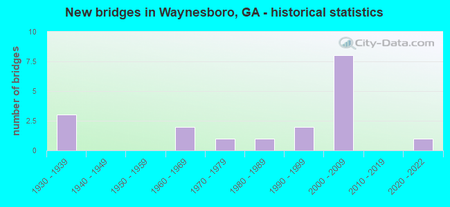
- New bridges - historical statistics
- 31930-1939
- 21960-1969
- 11970-1979
- 11980-1989
- 21990-1999
- 82000-2009
- 12020-2022
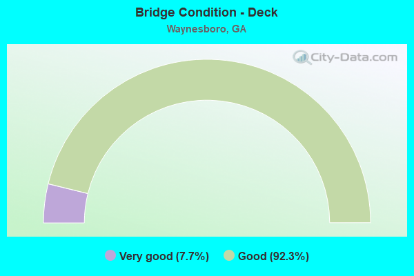
- Bridge Condition - Deck
- 7.7%Very good
- 92.3%Good
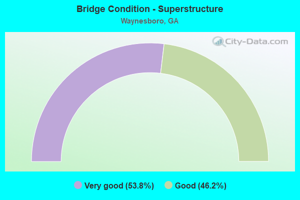
- Bridge Condition - Superstructure
- 53.8%Very good
- 46.2%Good
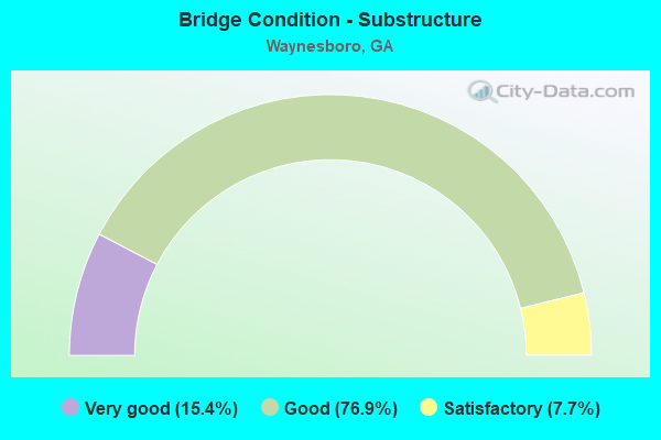
- Bridge Condition - Substructure
- 15.4%Very good
- 76.9%Good
- 7.7%Satisfactory
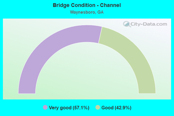
- Bridge Condition - Channel
- 57.1%Very good
- 42.9%Good
Find on map >> Show street view
Structure Number: 330013, Location: 4.5 MI SE OF WAYNESBORO (Lat: 33.054772, Lng: -81.951678), Route carried "on" structure: State highway 24, Year Built: 1936, Status: Open, Structure Length: 0.98m (3.22ft), Average Daily Traffic: 3,410 (year 2011), Truck Traffic: 1%, Average Future Daily Traffic: 5,115 (year 2031), Design Load: H 15, Features Intersected: FITZ BRANCH
Minimum Vertical Clearance: 30+ m (98+ ft), Kilometerpoint: 25.750, Lanes on structure: 2, Base Highway Network: Yes, Owner: State Highway Agency, Approaching Roadway Width: 8.8m (28.9ft), Material/Design: Concrete, Design/Construction: Culvert, Number Of Spans In Main Unit: 3, Length of Maximum Span: 3.0m (9.8ft)
Condition: Channel: Good, Culverts: Good, Operating Rating: 61.6 metric tons, Method Used To Determine Operating Rating: Load Factor (LF), Inventory Rating: 37.1 metric tons, Method Used To Determine Inventory Rating: Load Factor (LF), Structural Evaluation: Better than present minimum criteria, Waterway Adequacy: Equal to present desirable criteria, Approach Roadway Alignment: Equal to present desirable criteria, Designated Inspection Frequency: Every 24 months, Inspection Date: June 2020, Bridge Improvement Cost: $125,000, Roadway Improvement Cost: $13,000, Total Project Cost: $188,000
Find on map >> Show street view
Structure Number: 330014, Location: CITY OF WAYNESBORO (Lat: 33.079742, Lng: -82.008569), Route carried "on" structure: US 25, Year Built: 1930, Year Reconstructed: 1986, Status: Open, Structure Length: 0.64m (2.10ft), Average Daily Traffic: 12,200 (year 2011), Truck Traffic: 1%, Average Future Daily Traffic: 18,300 (year 2031), Design Load: H 15, Features Intersected: McINTOSH CREEK
Minimum Vertical Clearance: 30+ m (98+ ft), Kilometerpoint: 32.187, Lanes on structure: 5, Base Highway Network: Yes, Owner: State Highway Agency, Approaching Roadway Width: 19.5m (64.0ft), Material/Design: Concrete, Design/Construction: Culvert, Number Of Spans In Main Unit: 2, Length of Maximum Span: 3.0m (9.8ft), Curb or Sidewalk Widths: Left: 1.5m (4.9ft), Right: 1.5m (4.9ft)
Condition: Channel: Good, Culverts: Good, Operating Rating: 66.2 metric tons, Method Used To Determine Operating Rating: Load Factor (LF), Inventory Rating: 39.9 metric tons, Method Used To Determine Inventory Rating: Load Factor (LF), Structural Evaluation: Better than present minimum criteria, Waterway Adequacy: Equal to present desirable criteria, Approach Roadway Alignment: Equal to present desirable criteria, Designated Inspection Frequency: Every 24 months, Inspection Date: June 2020, Bridge Improvement Cost: $149,000, Roadway Improvement Cost: $15,000, Total Project Cost: $224,000
Find on map >> Show street view
Structure Number: 330015, Location: CITY OF WAYNESBORO (Lat: 33.086492, Lng: -82.026561), Route carried "on" structure: State highway 24, Year Built: 1983, Status: Open, Structure Length: 0.79m (2.59ft), Average Daily Traffic: 10,650 (year 2011), Truck Traffic: 1%, Average Future Daily Traffic: 15,975 (year 2031), Design Load: HS 20+Mod, Features Intersected: MAPLE BRANCH
Minimum Vertical Clearance: 30+ m (98+ ft), Kilometerpoint: 33.796, Lanes on structure: 3, Base Highway Network: Yes, Owner: State Highway Agency, Approaching Roadway Width: 12.8m (42.0ft), Skew: 3 degrees, Material/Design: Concrete, Design/Construction: Culvert, Number Of Spans In Main Unit: 4, Length of Maximum Span: 1.8m (5.9ft)
Condition: Channel: Good, Culverts: Good, Operating Rating: 29.0 metric tons, Method Used To Determine Operating Rating: Load Factor (LF), Inventory Rating: 17.2 metric tons, Method Used To Determine Inventory Rating: Load Factor (LF), Structural Evaluation: Meets minimum limits, Waterway Adequacy: Equal to present desirable criteria, Approach Roadway Alignment: Equal to present desirable criteria, Designated Inspection Frequency: Every 24 months, Inspection Date: June 2020, Bridge Improvement Cost: $129,000, Roadway Improvement Cost: $13,000, Total Project Cost: $194,000
Find on map >> Show street view
Structure Number: 330016, Location: 3 MI SW OF WAYNESBORO (Lat: 33.078108, Lng: -82.064897), Route carried "on" structure: State highway 24, Year Built: 1931, Status: Open, Structure Length: 0.70m (2.30ft), Average Daily Traffic: 1,720 (year 2011), Truck Traffic: 24%, Average Future Daily Traffic: 2,580 (year 2031), Design Load: H 15, Features Intersected: HARP BRANCH
Minimum Vertical Clearance: 30+ m (98+ ft), Kilometerpoint: 38.624, Lanes on structure: 2, Base Highway Network: Yes, Owner: State Highway Agency, Approaching Roadway Width: 8.5m (27.9ft), Material/Design: Concrete, Design/Construction: Culvert, Number Of Spans In Main Unit: 3, Length of Maximum Span: 2.1m (6.9ft)
Condition: Channel: Good, Culverts: Good, Operating Rating: 39.0 metric tons, Method Used To Determine Operating Rating: Load Factor (LF), Inventory Rating: 23.5 metric tons, Method Used To Determine Inventory Rating: Load Factor (LF), Structural Evaluation: Equal to present minimum criteria, Waterway Adequacy: Equal to present desirable criteria, Approach Roadway Alignment: Better than present minimum criteria, Designated Inspection Frequency: Every 24 months, Inspection Date: June 2020, Bridge Improvement Cost: $90,000, Roadway Improvement Cost: $9,000, Total Project Cost: $135,000
Find on map >> Show street view
Structure Number: 330052, Location: CITY OF WAYNESBORO (Lat: 33.103900, Lng: -82.017261), Route carried "on" structure: Bypass US 25, Year Built: 1968, Year Reconstructed: 1994, Status: Open, Structure Length: 4.27m (14.01ft), Average Daily Traffic: 7,080 (year 2011), Truck Traffic: 1%, Average Future Daily Traffic: 10,620 (year 2031), Design Load: HS 15, Features Intersected: NS RR (732986Y)
Minimum Vertical Clearance: 30+ m (98+ ft), Kilometerpoint: 6.437, Lanes on structure: 2, Base Highway Network: Yes, Owner: State Highway Agency, Approaching Roadway Width: 9.1m (29.9ft), Skew: 12 degrees, Material/Design: Steel, Design/Construction: Stringer/Multi-beam, Number Of Spans In Main Unit: 3, Length of Maximum Span: 14.3m (46.9ft), Curb-To-Curb Width: 11.6m (38.1ft), Out-to-Out Width: 12.6m (41.3ft)
Condition: Deck: Good, Superstructure: Good, Substructure: Good, Operating Rating: 36.2 metric tons, Method Used To Determine Operating Rating: Load Factor (LF), Inventory Rating: 21.7 metric tons, Method Used To Determine Inventory Rating: Load Factor (LF), Structural Evaluation: Somewhat better than minimum adequacy, Deck Geometry: Better than present minimum criteria, Underclear: Equal to present minimum criteria, Approach Roadway Alignment: Equal to present desirable criteria, Designated Inspection Frequency: Every 24 months, Inspection Date: June 2020, Bridge Improvement Cost: $547,000, Roadway Improvement Cost: $55,000, Total Project Cost: $821,000, Deck Structure Type: Concrete Cast-file-Place
Find on map >> Show street view
Structure Number: 330058, Location: CITY OF WAYNEBORO (Lat: 33.103711, Lng: -82.017131), Route carried "on" structure: Bypass US 25, Year Built: 1994, Status: Open, Structure Length: 5.06m (16.60ft), Average Daily Traffic: 7,080 (year 2011), Truck Traffic: 1%, Average Future Daily Traffic: 10,620 (year 2031), Design Load: HS 20+Mod, Features Intersected: NS RR (732986Y)
Minimum Vertical Clearance: 30+ m (98+ ft), Kilometerpoint: 6.437, Lanes on structure: 2, Base Highway Network: Yes, Owner: State Highway Agency, Approaching Roadway Width: 9.1m (29.9ft), Skew: 12 degrees, Material/Design: Prestressed concrete, Design/Construction: Stringer/Multi-beam, Number Of Spans In Main Unit: 3, Length of Maximum Span: 17.7m (58.1ft), Curb-To-Curb Width: 11.6m (38.1ft), Out-to-Out Width: 12.6m (41.3ft)
Condition: Deck: Good, Superstructure: Very good, Substructure: Good, Operating Rating: 62.5 metric tons, Method Used To Determine Operating Rating: Load Factor (LF), Inventory Rating: 37.1 metric tons, Method Used To Determine Inventory Rating: Load Factor (LF), Structural Evaluation: Better than present minimum criteria, Deck Geometry: Better than present minimum criteria, Underclear: Superior to present desirable criteria, Approach Roadway Alignment: Equal to present desirable criteria, Designated Inspection Frequency: Every 24 months, Inspection Date: June 2020, Bridge Improvement Cost: $649,000, Roadway Improvement Cost: $65,000, Total Project Cost: $973,000, Deck Structure Type: Concrete Cast-file-Place
Find on map >> Show street view
Structure Number: 330059, Location: 3.5 MI NE OF WAYNESBORO (Lat: 33.118669, Lng: -81.963397), Route carried "on" structure: State highway 56, Year Built: 1995, Status: Open, Structure Length: 15.24m (50.00ft), Average Daily Traffic: 6,810 (year 2011), Truck Traffic: 1%, Average Future Daily Traffic: 10,215 (year 2031), Design Load: HS 20+Mod, Features Intersected: BRIER CREEK
Minimum Vertical Clearance: 30+ m (98+ ft), Kilometerpoint: 43.452, Lanes on structure: 2, Base Highway Network: Yes, Owner: State Highway Agency, Approaching Roadway Width: 8.5m (27.9ft), Material/Design: Prestressed concrete, Design/Construction: Stringer/Multi-beam, Number Of Spans In Main Unit: 10, Length of Maximum Span: 27.4m (89.9ft), Curb-To-Curb Width: 13.4m (44.0ft), Out-to-Out Width: 14.4m (47.2ft)
Condition: Deck: Good, Superstructure: Good, Substructure: Good, Channel: Very good, Operating Rating: 62.5 metric tons, Method Used To Determine Operating Rating: Load Factor (LF), Inventory Rating: 37.1 metric tons, Method Used To Determine Inventory Rating: Load Factor (LF), Structural Evaluation: Better than present minimum criteria, Deck Geometry: Equal to present minimum criteria, Waterway Adequacy: Equal to present desirable criteria, Approach Roadway Alignment: Equal to present desirable criteria, Designated Inspection Frequency: Every 24 months, Underwater Inspection Frequency: Every 60 months, Inspection Date: June 2020, Underwater Inspection Date: August 2021, Bridge Improvement Cost: $1,954,000, Roadway Improvement Cost: $195,000, Total Project Cost: $2,930,000, Deck Structure Type: Concrete Cast-file-Place
Find on map >> Show street view
Structure Number: 335015, Location: 2.4 MI N OF WAYNESBORO (Lat: 33.137953, Lng: -82.028922), Route carried "on" structure: County highway 206, Year Built: 1966, Status: Posted for load, Structure Length: 3.02m (9.91ft), Average Daily Traffic: 600 (year 2011), Truck Traffic: 1%, Average Future Daily Traffic: 900 (year 2031), Design Load: H 15, Features Intersected: WALNUT BRANCH, Facility Carried by Structure: HADEN POND ROAD
Minimum Vertical Clearance: 30+ m (98+ ft), Kilometerpoint: 6.437, Lanes on structure: 2, Base Highway Network: Yes, Owner: County Highway Agency, Approaching Roadway Width: 7.3m (24.0ft), Material/Design: Concrete, Design/Construction: Tee Beam, Number Of Spans In Main Unit: 3, Length of Maximum Span: 10.1m (33.1ft), Curb or Sidewalk Widths: Left: 0.6m (2.0ft), Right: 0.6m (2.0ft), Curb-To-Curb Width: 7.3m (24.0ft), Out-to-Out Width: 9.2m (30.2ft)
Condition: Deck: Good, Superstructure: Good, Substructure: Satisfactory, Channel: Good, Operating Rating: 23.5 metric tons, Method Used To Determine Operating Rating: Load Factor (LF), Inventory Rating: 12.7 metric tons, Method Used To Determine Inventory Rating: Load Factor (LF), Structural Evaluation: Meets minimum limits, Deck Geometry: Meets minimum limits, Waterway Adequacy: Equal to present desirable criteria, Approach Roadway Alignment: Equal to present desirable criteria, Bridge Posting: Required (Relationship of Operating Rating to Maximum Legal Load: 20.0 - 29.9% below), Designated Inspection Frequency: Every 24 months, Inspection Date: June 2020, Bridge Improvement Cost: $387,000, Roadway Improvement Cost: $39,000, Total Project Cost: $580,000, Deck Structure Type: Concrete Cast-file-Place
Find on map >> Show street view
Structure Number: 335039, Location: 1.4 MI E OF WAYNESBORO (Lat: 33.088722, Lng: -81.992025), Route carried "on" structure: Bypass US 25, Year Built: 1979, Year Reconstructed: 1994, Status: Open, Structure Length: 0.88m (2.89ft), Average Daily Traffic: 4,700 (year 2011), Truck Traffic: 1%, Average Future Daily Traffic: 7,050 (year 2031), Design Load: HS 20+Mod, Features Intersected: McINTOSH CREEK, Facility Carried by Structure: SR 121 BYPASS
Minimum Vertical Clearance: 30+ m (98+ ft), Kilometerpoint: 3.219, Lanes on structure: 4, Base Highway Network: Yes, Owner: State Highway Agency, Approaching Roadway Width: 18.3m (60.0ft), Skew: 10 degrees, Material/Design: Concrete, Design/Construction: Culvert, Number Of Spans In Main Unit: 3, Length of Maximum Span: 2.7m (8.9ft)
Condition: Channel: Good, Culverts: Good, Structural Evaluation: Better than present minimum criteria, Waterway Adequacy: Equal to present desirable criteria, Approach Roadway Alignment: Equal to present desirable criteria, Designated Inspection Frequency: Every 24 months, Inspection Date: June 2020, Bridge Improvement Cost: $175,000, Roadway Improvement Cost: $18,000, Total Project Cost: $263,000
Find on map >> Show street view
Structure Number: 335045, Location: 3.3 MI N OF WAYNESBORO (Lat: 33.136308, Lng: -82.035747), Route carried "on" structure: US 25, Year Built: 2005, Status: Open, Structure Length: 4.48m (14.70ft), Average Daily Traffic: 8,840 (year 2011), Truck Traffic: 12%, Average Future Daily Traffic: 13,260 (year 2031), Design Load: HS 20+Mod, Features Intersected: WALNUT BRANCH
Minimum Vertical Clearance: 30+ m (98+ ft), Kilometerpoint: 25.750, Lanes on structure: 2, Base Highway Network: Yes, Owner: State Highway Agency, Approaching Roadway Width: 14.9m (48.9ft), Skew: 10 degrees, Material/Design: Prestressed concrete, Design/Construction: Stringer/Multi-beam, Number Of Spans In Main Unit: 3, Length of Maximum Span: 18.9m (62.0ft), Curb-To-Curb Width: 11.4m (37.4ft), Out-to-Out Width: 12.5m (41.0ft)
Condition: Deck: Good, Superstructure: Very good, Substructure: Good, Channel: Very good, Operating Rating: 50.8 metric tons, Method Used To Determine Operating Rating: Allowable Stress (AS), Inventory Rating: 32.6 metric tons, Method Used To Determine Inventory Rating: Allowable Stress (AS), Structural Evaluation: Better than present minimum criteria, Deck Geometry: Equal to present minimum criteria, Waterway Adequacy: Equal to present desirable criteria, Approach Roadway Alignment: Equal to present desirable criteria, Designated Inspection Frequency: Every 24 months, Inspection Date: June 2020, Bridge Improvement Cost: $574,000, Roadway Improvement Cost: $57,000, Total Project Cost: $862,000, Deck Structure Type: Concrete Cast-file-Place
Find on map >> Show street view
Structure Number: 335046, Location: 4.7 MI N OF WAYNESBORO (Lat: 33.155217, Lng: -82.037825), Route carried "on" structure: US 25, Year Built: 2005, Status: Open, Structure Length: 6.00m (19.69ft), Average Daily Traffic: 8,030 (year 2011), Truck Traffic: 1%, Average Future Daily Traffic: 12,045 (year 2031), Design Load: HS 20+Mod, Features Intersected: BRIER CREEK OVERFLOW
Minimum Vertical Clearance: 30+ m (98+ ft), Kilometerpoint: 27.359, Lanes on structure: 2, Base Highway Network: Yes, Owner: State Highway Agency, Approaching Roadway Width: 15.2m (49.9ft), Skew: 10 degrees, Material/Design: Prestressed concrete, Design/Construction: Stringer/Multi-beam, Number Of Spans In Main Unit: 5, Length of Maximum Span: 11.9m (39.0ft), Curb-To-Curb Width: 11.4m (37.4ft), Out-to-Out Width: 12.5m (41.0ft)
Condition: Deck: Good, Superstructure: Very good, Substructure: Good, Channel: Very good, Operating Rating: 50.8 metric tons, Method Used To Determine Operating Rating: Allowable Stress (AS), Inventory Rating: 32.6 metric tons, Method Used To Determine Inventory Rating: Allowable Stress (AS), Structural Evaluation: Better than present minimum criteria, Deck Geometry: Equal to present minimum criteria, Waterway Adequacy: Equal to present desirable criteria, Approach Roadway Alignment: Equal to present desirable criteria, Designated Inspection Frequency: Every 24 months, Inspection Date: June 2020, Bridge Improvement Cost: $770,000, Roadway Improvement Cost: $77,000, Total Project Cost: $1,155,000, Deck Structure Type: Concrete Cast-file-Place
Find on map >> Show street view
Structure Number: 335048, Location: 5 MI N OF WAYNESBORO (Lat: 33.159919, Lng: -82.038258), Route carried "on" structure: US 25, Year Built: 2005, Status: Open, Structure Length: 26.97m (88.48ft), Average Daily Traffic: 8,030 (year 2011), Truck Traffic: 1%, Average Future Daily Traffic: 12,045 (year 2031), Design Load: HS 20+Mod, Features Intersected: BRIER CREEK
Minimum Vertical Clearance: 30+ m (98+ ft), Kilometerpoint: 27.359, Lanes on structure: 2, Base Highway Network: Yes, Owner: State Highway Agency, Approaching Roadway Width: 15.5m (50.9ft), Skew: 10 degrees, Material/Design: Prestressed concrete, Design/Construction: Stringer/Multi-beam, Number Of Spans In Main Unit: 15, Length of Maximum Span: 18.0m (59.1ft), Curb-To-Curb Width: 11.4m (37.4ft), Out-to-Out Width: 12.5m (41.0ft)
Condition: Deck: Good, Superstructure: Good, Substructure: Good, Channel: Very good, Operating Rating: 48.9 metric tons, Method Used To Determine Operating Rating: Load Factor (LF), Inventory Rating: 28.1 metric tons, Method Used To Determine Inventory Rating: Load Factor (LF), Structural Evaluation: Better than present minimum criteria, Deck Geometry: Equal to present minimum criteria, Waterway Adequacy: Equal to present desirable criteria, Approach Roadway Alignment: Equal to present desirable criteria, Designated Inspection Frequency: Every 24 months, Inspection Date: June 2020, Bridge Improvement Cost: $3,458,000, Roadway Improvement Cost: $346,000, Total Project Cost: $5,187,000, Deck Structure Type: Concrete Cast-file-Place
Find on map >> Show street view
Structure Number: 335049, Location: 3.3 MI N OF WAYNESBORO (Lat: 33.136328, Lng: -82.035978), Route carried "on" structure: US 25, Year Built: 2008, Status: Open, Structure Length: 4.33m (14.21ft), Average Daily Traffic: 8,840 (year 2011), Truck Traffic: 12%, Average Future Daily Traffic: 13,260 (year 2031), Design Load: HS 20+Mod, Features Intersected: WALNUT BRANCH
Minimum Vertical Clearance: 30+ m (98+ ft), Kilometerpoint: 25.750, Lanes on structure: 2, Base Highway Network: Yes, Owner: State Highway Agency, Approaching Roadway Width: 15.2m (49.9ft), Skew: 10 degrees, Material/Design: Prestressed concrete, Design/Construction: Stringer/Multi-beam, Number Of Spans In Main Unit: 3, Length of Maximum Span: 17.4m (57.1ft), Curb-To-Curb Width: 11.4m (37.4ft), Out-to-Out Width: 12.5m (41.0ft)
Condition: Deck: Good, Superstructure: Very good, Substructure: Good, Channel: Very good, Operating Rating: 52.6 metric tons, Method Used To Determine Operating Rating: Allowable Stress (AS), Inventory Rating: 31.7 metric tons, Method Used To Determine Inventory Rating: Allowable Stress (AS), Structural Evaluation: Better than present minimum criteria, Deck Geometry: Equal to present minimum criteria, Waterway Adequacy: Equal to present desirable criteria, Approach Roadway Alignment: Equal to present desirable criteria, Designated Inspection Frequency: Every 24 months, Inspection Date: June 2020, Bridge Improvement Cost: $555,000, Roadway Improvement Cost: $55,000, Total Project Cost: $832,000, Deck Structure Type: Concrete Cast-file-Place
Find on map >> Show street view
Structure Number: 33505, Location: 4.7 MI N OF WAYNESBORO (Lat: 33.155222, Lng: -82.037600), Route carried "on" structure: US 25, Year Built: 2008, Status: Open, Structure Length: 6.00m (19.69ft), Average Daily Traffic: 8,030 (year 2011), Truck Traffic: 1%, Average Future Daily Traffic: 12,045 (year 2031), Design Load: HS 20+Mod, Features Intersected: BRIER CREEK OVERFLOW
Minimum Vertical Clearance: 30+ m (98+ ft), Kilometerpoint: 27.359, Lanes on structure: 2, Base Highway Network: Yes, Owner: State Highway Agency, Approaching Roadway Width: 16.2m (53.1ft), Skew: 10 degrees, Material/Design: Prestressed concrete, Design/Construction: Stringer/Multi-beam, Number Of Spans In Main Unit: 5, Length of Maximum Span: 11.9m (39.0ft), Curb-To-Curb Width: 11.4m (37.4ft), Out-to-Out Width: 12.5m (41.0ft)
Condition: Deck: Good, Superstructure: Very good, Substructure: Very good, Channel: Very good, Operating Rating: 50.8 metric tons, Method Used To Determine Operating Rating: Allowable Stress (AS), Inventory Rating: 32.6 metric tons, Method Used To Determine Inventory Rating: Allowable Stress (AS), Structural Evaluation: Equal to present desirable criteria, Deck Geometry: Equal to present minimum criteria, Waterway Adequacy: Equal to present desirable criteria, Approach Roadway Alignment: Equal to present desirable criteria, Designated Inspection Frequency: Every 24 months, Inspection Date: June 2020, Bridge Improvement Cost: $770,000, Roadway Improvement Cost: $77,000, Total Project Cost: $1,155,000, Deck Structure Type: Concrete Cast-file-Place
Find on map >> Show street view
Structure Number: 335051, Location: 5 MI N OF WAYNESBORO (Lat: 33.159939, Lng: -82.038008), Route carried "on" structure: US 25, Year Built: 2008, Status: Open, Structure Length: 26.97m (88.48ft), Average Daily Traffic: 8,030 (year 2011), Truck Traffic: 1%, Average Future Daily Traffic: 12,045 (year 2031), Design Load: HS 20+Mod, Features Intersected: BRIER CREEK
Minimum Vertical Clearance: 30+ m (98+ ft), Kilometerpoint: 27.359, Lanes on structure: 2, Base Highway Network: Yes, Owner: State Highway Agency, Approaching Roadway Width: 15.8m (51.8ft), Skew: 10 degrees, Material/Design: Prestressed concrete, Design/Construction: Stringer/Multi-beam, Number Of Spans In Main Unit: 15, Length of Maximum Span: 18.0m (59.1ft), Curb-To-Curb Width: 11.4m (37.4ft), Out-to-Out Width: 12.5m (41.0ft)
Condition: Deck: Good, Superstructure: Good, Substructure: Good, Channel: Very good, Operating Rating: 37.1 metric tons, Method Used To Determine Operating Rating: Load Factor (LF), Inventory Rating: 28.1 metric tons, Method Used To Determine Inventory Rating: Load Factor (LF), Structural Evaluation: Better than present minimum criteria, Deck Geometry: Equal to present minimum criteria, Waterway Adequacy: Equal to present desirable criteria, Approach Roadway Alignment: Equal to present desirable criteria, Designated Inspection Frequency: Every 24 months, Inspection Date: June 2020, Bridge Improvement Cost: $3,458,000, Roadway Improvement Cost: $346,000, Total Project Cost: $5,187,000, Deck Structure Type: Concrete Cast-file-Place
Find on map >> Show street view
Structure Number: 335053, Location: 2 MI SE OF WAYNESBORO (Lat: 33.067975, Lng: -82.000903), Route carried "on" structure: Bypass US 25, Year Built: 2005, Status: Open, Structure Length: 18.35m (60.20ft), Average Daily Traffic: 4,880 (year 2011), Truck Traffic: 1%, Average Future Daily Traffic: 7,320 (year 2031), Design Load: HS 20+Mod, Features Intersected: SR 121 (US 25) NS RR
Minimum Vertical Clearance: 30+ m (98+ ft), Kilometerpoint: 16.093, Lanes on structure: 2, Lanes under structure: 2, Base Highway Network: Yes, Owner: State Highway Agency, Approaching Roadway Width: 9.1m (29.9ft), Skew: 13 degrees, Material/Design: Prestressed concrete, Design/Construction: Stringer/Multi-beam, Number Of Spans In Main Unit: 7, Length of Maximum Span: 32.6m (107.0ft), Curb-To-Curb Width: 11.4m (37.4ft), Out-to-Out Width: 12.4m (40.7ft)
Condition: Deck: Good, Superstructure: Good, Substructure: Good, Operating Rating: 59.8 metric tons, Method Used To Determine Operating Rating: Load Factor (LF), Inventory Rating: 30.8 metric tons, Method Used To Determine Inventory Rating: Load Factor (LF), Structural Evaluation: Better than present minimum criteria, Deck Geometry: Equal to present minimum criteria, Underclear: Better than present minimum criteria, Approach Roadway Alignment: Equal to present desirable criteria, Designated Inspection Frequency: Every 24 months, Inspection Date: June 2020, Bridge Improvement Cost: $2,352,000, Roadway Improvement Cost: $235,000, Total Project Cost: $3,528,000, Deck Structure Type: Concrete Cast-file-Place
Find on map >> Show street view
Structure Number: 335054, Location: 2 MI SE OF WAYNESBORO (Lat: 33.068144, Lng: -82.001056), Route carried "on" structure: Bypass US 25, Year Built: 2005, Status: Open, Structure Length: 18.35m (60.20ft), Average Daily Traffic: 4,880 (year 2011), Truck Traffic: 1%, Average Future Daily Traffic: 7,320 (year 2031), Design Load: HS 20+Mod, Features Intersected: SR 121 (US25) NS RR
Minimum Vertical Clearance: 30+ m (98+ ft), Kilometerpoint: 16.093, Lanes on structure: 2, Lanes under structure: 2, Base Highway Network: Yes, Owner: State Highway Agency, Approaching Roadway Width: 9.1m (29.9ft), Skew: 13 degrees, Material/Design: Prestressed concrete, Design/Construction: Stringer/Multi-beam, Number Of Spans In Main Unit: 7, Length of Maximum Span: 32.6m (107.0ft), Curb-To-Curb Width: 11.4m (37.4ft), Out-to-Out Width: 12.4m (40.7ft)
Condition: Deck: Good, Superstructure: Very good, Substructure: Good, Operating Rating: 61.6 metric tons, Method Used To Determine Operating Rating: Load Factor (LF), Inventory Rating: 31.7 metric tons, Method Used To Determine Inventory Rating: Load Factor (LF), Structural Evaluation: Better than present minimum criteria, Deck Geometry: Equal to present minimum criteria, Underclear: Better than present minimum criteria, Approach Roadway Alignment: Equal to present desirable criteria, Designated Inspection Frequency: Every 24 months, Inspection Date: June 2020, Bridge Improvement Cost: $2,352,000, Roadway Improvement Cost: $235,000, Total Project Cost: $3,528,000, Deck Structure Type: Concrete Cast-file-Place
Find on map >> Show street view
Structure Number: 335055, Location: 2.8 MI NW OF WAYNESBORO (Lat: 33.114867, Lng: -82.053397), Route carried "on" structure: County highway 1290, Year Built: 2020, Status: Open, Structure Length: 2.44m (8.01ft), Average Daily Traffic: 920 (year 2011), Truck Traffic: 1%, Average Future Daily Traffic: 1,380 (year 2031), Design Load: HS 20+Mod, Features Intersected: WALNUT BRANCH, Facility Carried by Structure: QUAKER ROAD
Minimum Vertical Clearance: 30+ m (98+ ft), Kilometerpoint: 16.093, Lanes on structure: 2, Base Highway Network: Yes, Owner: County Highway Agency, Approaching Roadway Width: 6.1m (20.0ft), Material/Design: Prestressed concrete, Design/Construction: Box Beam or Girders - Multiple, Number Of Spans In Main Unit: 1, Length of Maximum Span: 24.4m (80.1ft), Curb-To-Curb Width: 9.1m (29.9ft), Out-to-Out Width: 10.1m (33.1ft)
Condition: Deck: Very good, Superstructure: Very good, Substructure: Very good, Channel: Very good, Operating Rating: 71.6 metric tons, Method Used To Determine Operating Rating: Load Factor (LF), Inventory Rating: 38.1 metric tons, Method Used To Determine Inventory Rating: Load Factor (LF), Structural Evaluation: Equal to present desirable criteria, Deck Geometry: Equal to present minimum criteria, Waterway Adequacy: Better than present minimum criteria, Approach Roadway Alignment: Better than present minimum criteria, Length Of Structure Improvement: 2.93m (9.61ft), Designated Inspection Frequency: Every 24 months, Inspection Date: July 2020, Bridge Improvement Cost: $7,104,000, Roadway Improvement Cost: $710,000, Total Project Cost: $10,656,000 ( Estimate for 2020), Deck Structure Type: Concrete Precast Panels, Wearing Surface/Protective System: Wearing Surface: Bituminous, Membrane: Preformed Fabric
Find on map >> Show street view
Structure Number: 33504, Location: IN CITY OF WAYNESBORO (Lat: 33.098244, Lng: -82.017992), Route carried "under" structure: City street 651, Structure Length: 0. m, Average Daily Traffic: 1,096 (year 2011), Truck Traffic: 1%, Features Intersected: CS 651 WATERS STREET, Facility Carried by Structure: NOR-SOU RR 620293S
Minimum Vertical Clearance: 3.96m (12.99ft), Kilometerpoint: 0.000, Length of Maximum Span: 0.0m
Find on map >> Show street view
Structure Number: 335053, Location: 2 MI SE OF WAYNESBORO (Lat: 33.067975, Lng: -82.000903), Route carried "under" structure: Business US 25, Structure Length: 0. m, Average Daily Traffic: 13,530 (year 2003), Truck Traffic: 5%, Features Intersected: SR 121 (US 25) BYPASS
Minimum Vertical Clearance: 5.08m (16.67ft), Kilometerpoint: 16.093, Lanes on structure: 2, Length of Maximum Span: 0.0m
Find on map >> Show street view
Structure Number: 335054, Location: 2 MI SE OF WAYNESBORO (Lat: 33.068144, Lng: -82.001056), Route carried "under" structure: Business US 25, Structure Length: 0. m, Average Daily Traffic: 13,530 (year 2003), Truck Traffic: 5%, Features Intersected: SR 121 (US 25) BYPASS
Minimum Vertical Clearance: 5.63m (18.47ft), Kilometerpoint: 16.093, Lanes on structure: 2, Length of Maximum Span: 0.0m