Bridge Statistics for West Branch, Michigan (MI)
Condition, Traffic, Stress, Structural Evaluation, Project Costs
- National Bridge Inventory (NBI) Statistics
- 28Number of bridges
- 233ft / 71.0mTotal length
- $254,000Total costs
- 131,109Total average daily traffic
- 10,997Total average daily truck traffic
- National Bridge Inventory (NBI) Registered Bridges for West Branch
- No street view available for this location
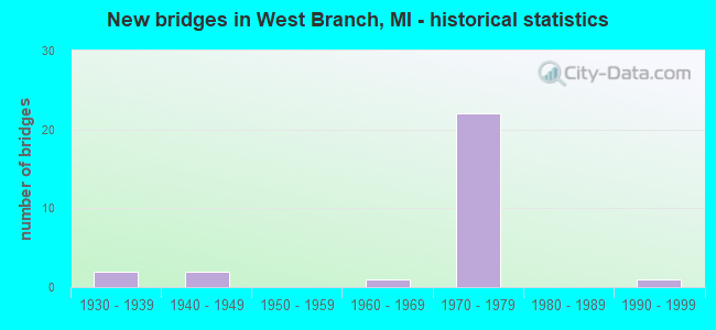
- New bridges - historical statistics
- 21930-1939
- 21940-1949
- 11960-1969
- 221970-1979
- 11990-1999
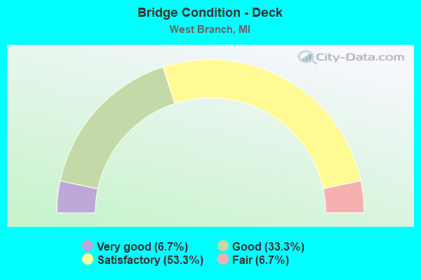
- Bridge Condition - Deck
- 6.7%Very good
- 33.3%Good
- 53.3%Satisfactory
- 6.7%Fair
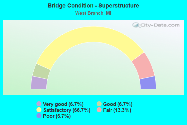
- Bridge Condition - Superstructure
- 6.7%Very good
- 6.7%Good
- 66.7%Satisfactory
- 13.3%Fair
- 6.7%Poor
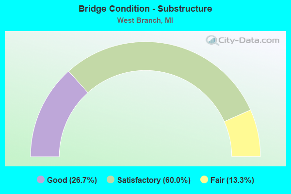
- Bridge Condition - Substructure
- 26.7%Good
- 60.0%Satisfactory
- 13.3%Fair
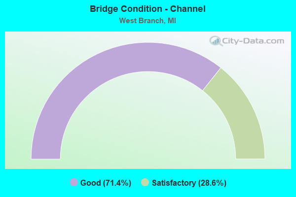
- Bridge Condition - Channel
- 71.4%Good
- 28.6%Satisfactory
Find on map >> Show street view
Structure Number: 846, Location: 2.3 MI E OF I-196 (Lat: 42.157342, Lng: -86.335886), Route carried "on" structure: County highway , Year Built: 1960, Status: Open, Structure Length: 10.99m (36.06ft), Average Daily Traffic: 70 (year 2007), Truck Traffic: 3%, Average Future Daily Traffic: 77 (year 2022), Design Load: H 15, Features Intersected: I-94, Facility Carried by Structure: CARMODY ROAD
Minimum Vertical Clearance: 30.48m (100.00ft), Kilometerpoint: 1.136, Lanes on structure: 2, Lanes under structure: 4, Owner: State Highway Agency, Approaching Roadway Width: 7.9m (25.9ft), Skew: 4 degrees, Material/Design: Concrete continuous, Design/Construction: Tee Beam, Number Of Spans In Main Unit: 4, Length of Maximum Span: 31.3m (102.7ft), Curb-To-Curb Width: 7.9m (25.9ft), Out-to-Out Width: 10.2m (33.5ft)
Condition: Deck: Satisfactory, Superstructure: Satisfactory, Substructure: Good, Operating Rating: 65.8 metric tons, Method Used To Determine Operating Rating: Load Factor (LF) rating reported by rating factor (RF) method using MS18 loading, Inventory Rating: 39.2 metric tons, Method Used To Determine Inventory Rating: Load Factor (LF) rating reported by rating factor (RF) method using MS18 loading, Structural Evaluation: Equal to present minimum criteria, Deck Geometry: Equal to present minimum criteria, Underclear: Somewhat better than minimum adequacy, Approach Roadway Alignment: Equal to present desirable criteria, Length Of Structure Improvement: 11.01m (36.12ft), Designated Inspection Frequency: Every 24 months, Inspection Date: June 2020, Bridge Improvement Cost: $122,000, Roadway Improvement Cost: $22,000, Total Project Cost: $254,000, Deck Structure Type: Concrete Cast-file-Place, Wearing Surface/Protective System: Wearing Surface: Latex Concrete
Find on map >> Show street view
Structure Number: 8412, Location: 1.6 MI E OF WEST BRANCH (Lat: 44.277272, Lng: -84.207864), Route carried "on" structure: State highway 55, Year Built: 1938, Status: Open, Structure Length: 0.70m (2.30ft), Average Daily Traffic: 7,822 (year 2007), Truck Traffic: 4%, Average Future Daily Traffic: 11,193 (year 2018), Design Load: H 15, Features Intersected: BR OF RIFLE RIVER
Minimum Vertical Clearance: 30.48m (100.00ft), Kilometerpoint: 1.325, Lanes on structure: 2, Base Highway Network: Yes (Inventory Route: 100, Subroute: 1), Owner: State Highway Agency, Approaching Roadway Width: 12.8m (42.0ft), Material/Design: Concrete, Design/Construction: Tee Beam, Number Of Spans In Main Unit: 1, Length of Maximum Span: 7.0m (23.0ft), Curb-To-Curb Width: 9.8m (32.2ft), Out-to-Out Width: 18.9m (62.0ft)
Condition: Deck: Very good, Superstructure: Satisfactory, Substructure: Fair, Channel: Good, Operating Rating: 54.5 metric tons, Method Used To Determine Operating Rating: Field evaluation and documented engineering judgment, Inventory Rating: 32.7 metric tons, Method Used To Determine Inventory Rating: Field evaluation and documented engineering judgment, Structural Evaluation: Somewhat better than minimum adequacy, Deck Geometry: Meets minimum limits, Waterway Adequacy: Equal to present minimum criteria, Approach Roadway Alignment: Equal to present desirable criteria, Designated Inspection Frequency: Every 24 months, Inspection Date: May 2021, Deck Structure Type: Concrete Cast-file-Place
Find on map >> Show street view
Structure Number: 8418, Location: 0.3 MI SE OF M-55 (Lat: 44.267683, Lng: -84.217983), Route carried "on" structure: Business Interstate 75, Year Built: 1932, Status: Open, Structure Length: 0.94m (3.08ft), Average Daily Traffic: 13,157 (year 2017), Truck Traffic: 3%, Average Future Daily Traffic: 15,130 (year 2037), Design Load: H 15, Features Intersected: OGEMAW CREEK
Minimum Vertical Clearance: 30.48m (100.00ft), Kilometerpoint: 10.382, Lanes on structure: 2, Owner: State Highway Agency, Approaching Roadway Width: 12.2m (40.0ft), Material/Design: Concrete, Design/Construction: Tee Beam, Number Of Spans In Main Unit: 1, Length of Maximum Span: 9.4m (30.8ft), Curb-To-Curb Width: 9.1m (29.9ft), Out-to-Out Width: 16.2m (53.1ft)
Condition: Deck: Satisfactory, Superstructure: Satisfactory, Substructure: Satisfactory, Channel: Good, Operating Rating: 82.9 metric tons, Method Used To Determine Operating Rating: Load Factor (LF) rating reported by rating factor (RF) method using MS18 loading, Inventory Rating: 49.6 metric tons, Method Used To Determine Inventory Rating: Load Factor (LF) rating reported by rating factor (RF) method using MS18 loading, Structural Evaluation: Equal to present minimum criteria, Deck Geometry: High priority of corrective action, Waterway Adequacy: Equal to present desirable criteria, Approach Roadway Alignment: Equal to present desirable criteria, Designated Inspection Frequency: Every 24 months, Inspection Date: July 2021, Deck Structure Type: Concrete Cast-file-Place, Wearing Surface/Protective System: Wearing Surface: Bituminous
Find on map >> Show street view
Structure Number: 8426, Location: 3.0 MI S OF WEST BRANCH (Lat: 44.233406, Lng: -84.213886), Route carried "on" structure: County highway 6520, Year Built: 1970, Status: Open, Structure Length: 5.24m (17.19ft), Average Daily Traffic: 843 (year 1997), Truck Traffic: 3%, Average Future Daily Traffic: 500 (year 1977), Design Load: H 15, Features Intersected: I-75 SB, Facility Carried by Structure: RAU ROAD
Minimum Vertical Clearance: 30.48m (100.00ft), Kilometerpoint: 14.306, Lanes on structure: 2, Lanes under structure: 2, Owner: State Highway Agency, Approaching Roadway Width: 12.8m (42.0ft), Skew: 1 degrees, Material/Design: Steel, Design/Construction: Stringer/Multi-beam, Number Of Spans In Main Unit: 3, Length of Maximum Span: 28.6m (93.8ft), Curb or Sidewalk Widths: Left: 0.2m (0.7ft), Right: 0.2m (0.7ft), Curb-To-Curb Width: 10.9m (35.8ft), Out-to-Out Width: 11.7m (38.4ft)
Condition: Deck: Good, Superstructure: Satisfactory, Substructure: Good, Operating Rating: 51.2 metric tons, Method Used To Determine Operating Rating: Load Factor (LF) rating reported by rating factor (RF) method using MS18 loading, Inventory Rating: 30.8 metric tons, Method Used To Determine Inventory Rating: Load Factor (LF) rating reported by rating factor (RF) method using MS18 loading, Structural Evaluation: Equal to present minimum criteria, Deck Geometry: Equal to present minimum criteria, Underclear: Somewhat better than minimum adequacy, Approach Roadway Alignment: Better than present minimum criteria, Designated Inspection Frequency: Every 24 months, Inspection Date: October 2021, Deck Structure Type: Concrete Cast-file-Place, Wearing Surface/Protective System: Wearing Surface: Monolithic Concrete
Find on map >> Show street view
Structure Number: 8427, Location: 3.0 MI S OF WEST BRANCH (Lat: 44.233425, Lng: -84.212681), Route carried "on" structure: County highway 6520, Year Built: 1970, Status: Open, Structure Length: 5.45m (17.88ft), Average Daily Traffic: 843 (year 1997), Truck Traffic: 3%, Average Future Daily Traffic: 500 (year 1977), Design Load: H 15, Features Intersected: I-75 NB, Facility Carried by Structure: RAU ROAD
Minimum Vertical Clearance: 30.48m (100.00ft), Kilometerpoint: 14.403, Lanes on structure: 2, Lanes under structure: 3, Owner: State Highway Agency, Approaching Roadway Width: 12.8m (42.0ft), Skew: 1 degrees, Material/Design: Steel, Design/Construction: Stringer/Multi-beam, Number Of Spans In Main Unit: 3, Length of Maximum Span: 31.7m (104.0ft), Curb or Sidewalk Widths: Left: 0.2m (0.7ft), Right: 0.2m (0.7ft), Curb-To-Curb Width: 10.9m (35.8ft), Out-to-Out Width: 11.7m (38.4ft)
Condition: Deck: Good, Superstructure: Good, Substructure: Good, Operating Rating: 64.5 metric tons, Method Used To Determine Operating Rating: Load Factor (LF) rating reported by rating factor (RF) method using MS18 loading, Inventory Rating: 38.6 metric tons, Method Used To Determine Inventory Rating: Load Factor (LF) rating reported by rating factor (RF) method using MS18 loading, Structural Evaluation: Better than present minimum criteria, Deck Geometry: Equal to present minimum criteria, Underclear: Somewhat better than minimum adequacy, Approach Roadway Alignment: Better than present minimum criteria, Designated Inspection Frequency: Every 24 months, Inspection Date: October 2021, Deck Structure Type: Concrete Cast-file-Place, Wearing Surface/Protective System: Wearing Surface: Monolithic Concrete
Find on map >> Show street view
Structure Number: 8428, Location: 1.7 MI S OF W BRANCH@COL (Lat: 44.244683, Lng: -84.225511), Route carried "on" structure: Interstate 75, Year Built: 1972, Status: Open, Structure Length: 6.31m (20.70ft), Average Daily Traffic: 6,499 (year 2007), Truck Traffic: 11%, Average Future Daily Traffic: 8,478 (year 2018), Design Load: HS 20+Mod, Features Intersected: I-75 BL COOK RD
Minimum Vertical Clearance: 30.48m (100.00ft), Kilometerpoint: 10.765, Lanes on structure: 2, Lanes under structure: 2, Base Highway Network: Yes (Inventory Route: 100, Subroute: 3), Owner: State Highway Agency, Approaching Roadway Width: 14.0m (45.9ft), Skew: 3 degrees, Material/Design: Steel, Design/Construction: Stringer/Multi-beam, Number Of Spans In Main Unit: 3, Length of Maximum Span: 34.1m (111.9ft), Curb or Sidewalk Widths: Left: 0.2m (0.7ft), Right: 0.2m (0.7ft), Curb-To-Curb Width: 13.2m (43.3ft), Out-to-Out Width: 13.5m (44.3ft)
Condition: Deck: Satisfactory, Superstructure: Fair, Substructure: Satisfactory, Operating Rating: 69.7 metric tons, Method Used To Determine Operating Rating: Load Factor (LF) rating reported by rating factor (RF) method using MS18 loading, Inventory Rating: 41.8 metric tons, Method Used To Determine Inventory Rating: Load Factor (LF) rating reported by rating factor (RF) method using MS18 loading, Structural Evaluation: Somewhat better than minimum adequacy, Deck Geometry: Superior to present desirable criteria, Underclear: Superior to present desirable criteria, Approach Roadway Alignment: Better than present minimum criteria, Designated Inspection Frequency: Every 24 months, Inspection Date: October 2021, Deck Structure Type: Concrete Cast-file-Place, Wearing Surface/Protective System: Wearing Surface: Monolithic Concrete
Find on map >> Show street view
Structure Number: 8429, Location: 1.7 MI S OF W BRANCH@COL (Lat: 44.245733, Lng: -84.225511), Route carried "on" structure: Interstate 75, Year Built: 1972, Status: Open, Structure Length: 6.15m (20.18ft), Average Daily Traffic: 6,499 (year 2007), Truck Traffic: 11%, Average Future Daily Traffic: 8,478 (year 2018), Design Load: HS 20+Mod, Features Intersected: I-75 BL COOK RD
Minimum Vertical Clearance: 30.48m (100.00ft), Kilometerpoint: 10.944, Lanes on structure: 2, Lanes under structure: 2, Base Highway Network: Yes (Inventory Route: 100, Subroute: 2), Owner: State Highway Agency, Approaching Roadway Width: 14.0m (45.9ft), Skew: 3 degrees, Material/Design: Steel, Design/Construction: Stringer/Multi-beam, Number Of Spans In Main Unit: 3, Length of Maximum Span: 33.2m (108.9ft), Curb or Sidewalk Widths: Left: 0.2m (0.7ft), Right: 0.2m (0.7ft), Curb-To-Curb Width: 12.8m (42.0ft), Out-to-Out Width: 13.5m (44.3ft)
Condition: Deck: Satisfactory, Superstructure: Satisfactory, Substructure: Fair, Operating Rating: 74.2 metric tons, Method Used To Determine Operating Rating: Load Factor (LF) rating reported by rating factor (RF) method using MS18 loading, Inventory Rating: 44.4 metric tons, Method Used To Determine Inventory Rating: Load Factor (LF) rating reported by rating factor (RF) method using MS18 loading, Structural Evaluation: Somewhat better than minimum adequacy, Deck Geometry: Equal to present desirable criteria, Underclear: Better than present minimum criteria, Approach Roadway Alignment: Equal to present minimum criteria, Designated Inspection Frequency: Every 24 months, Inspection Date: October 2021, Deck Structure Type: Concrete Cast-file-Place, Wearing Surface/Protective System: Wearing Surface: Monolithic Concrete
Find on map >> Show street view
Structure Number: 843, Location: 2.0 MI S OF WEST BRANCH (Lat: 44.255064, Lng: -84.247178), Route carried "on" structure: Interstate 75, Year Built: 1972, Status: Open, Structure Length: 5.73m (18.80ft), Average Daily Traffic: 4,883 (year 2007), Truck Traffic: 11%, Average Future Daily Traffic: 8,478 (year 2018), Design Load: HS 20+Mod, Features Intersected: M-30
Minimum Vertical Clearance: 30.48m (100.00ft), Kilometerpoint: 12.869, Lanes on structure: 2, Lanes under structure: 2, Base Highway Network: Yes (Inventory Route: 100, Subroute: 3), Owner: State Highway Agency, Approaching Roadway Width: 14.0m (45.9ft), Skew: 2 degrees, Material/Design: Steel, Design/Construction: Stringer/Multi-beam, Number Of Spans In Main Unit: 3, Length of Maximum Span: 28.9m (94.8ft), Curb or Sidewalk Widths: Left: 0.2m (0.7ft), Right: 0.2m (0.7ft), Curb-To-Curb Width: 12.8m (42.0ft), Out-to-Out Width: 13.5m (44.3ft)
Condition: Deck: Satisfactory, Superstructure: Satisfactory, Substructure: Satisfactory, Operating Rating: 70.6 metric tons, Method Used To Determine Operating Rating: Load Factor (LF) rating reported by rating factor (RF) method using MS18 loading, Inventory Rating: 42.4 metric tons, Method Used To Determine Inventory Rating: Load Factor (LF) rating reported by rating factor (RF) method using MS18 loading, Structural Evaluation: Equal to present minimum criteria, Deck Geometry: Equal to present desirable criteria, Underclear: Equal to present minimum criteria, Approach Roadway Alignment: Equal to present minimum criteria, Designated Inspection Frequency: Every 24 months, Inspection Date: October 2021, Deck Structure Type: Concrete Cast-file-Place, Wearing Surface/Protective System: Wearing Surface: Monolithic Concrete
Find on map >> Show street view
Structure Number: 8431, Location: 2.0 MI S OF WEST BRANCH (Lat: 44.255969, Lng: -84.246781), Route carried "on" structure: Interstate 75, Year Built: 1972, Status: Open, Structure Length: 5.91m (19.39ft), Average Daily Traffic: 4,883 (year 2007), Truck Traffic: 11%, Average Future Daily Traffic: 8,478 (year 2018), Design Load: HS 20+Mod, Features Intersected: M-30
Minimum Vertical Clearance: 30.48m (100.00ft), Kilometerpoint: 13.012, Lanes on structure: 2, Lanes under structure: 2, Base Highway Network: Yes (Inventory Route: 100, Subroute: 2), Owner: State Highway Agency, Approaching Roadway Width: 14.0m (45.9ft), Skew: 2 degrees, Material/Design: Steel, Design/Construction: Stringer/Multi-beam, Number Of Spans In Main Unit: 3, Length of Maximum Span: 30.1m (98.8ft), Curb or Sidewalk Widths: Left: 0.2m (0.7ft), Right: 0.2m (0.7ft), Curb-To-Curb Width: 12.8m (42.0ft), Out-to-Out Width: 13.5m (44.3ft)
Condition: Deck: Satisfactory, Superstructure: Satisfactory, Substructure: Satisfactory, Operating Rating: 70.3 metric tons, Method Used To Determine Operating Rating: Load Factor (LF) rating reported by rating factor (RF) method using MS18 loading, Inventory Rating: 42.1 metric tons, Method Used To Determine Inventory Rating: Load Factor (LF) rating reported by rating factor (RF) method using MS18 loading, Structural Evaluation: Equal to present minimum criteria, Deck Geometry: Equal to present desirable criteria, Underclear: Better than present minimum criteria, Approach Roadway Alignment: Better than present minimum criteria, Designated Inspection Frequency: Every 24 months, Inspection Date: October 2021, Deck Structure Type: Concrete Cast-file-Place, Wearing Surface/Protective System: Wearing Surface: Monolithic Concrete
Find on map >> Show street view
Structure Number: 8432, Location: 2.0 MI W OF WEST BRANCH (Lat: 44.276336, Lng: -84.283058), Route carried "on" structure: Interstate 75, Year Built: 1972, Status: Open, Structure Length: 6.14m (20.14ft), Average Daily Traffic: 7,700 (year 2017), Truck Traffic: 9%, Average Future Daily Traffic: 8,855 (year 2037), Design Load: HS 20+Mod, Features Intersected: M-55
Minimum Vertical Clearance: 30.48m (100.00ft), Kilometerpoint: 16.659, Lanes on structure: 2, Lanes under structure: 2, Base Highway Network: Yes (Inventory Route: 100, Subroute: 3), Owner: State Highway Agency, Approaching Roadway Width: 14.0m (45.9ft), Skew: 3 degrees, Material/Design: Steel, Design/Construction: Stringer/Multi-beam, Number Of Spans In Main Unit: 3, Length of Maximum Span: 33.2m (108.9ft), Curb-To-Curb Width: 12.4m (40.7ft), Out-to-Out Width: 13.4m (44.0ft)
Condition: Deck: Good, Superstructure: Satisfactory, Substructure: Satisfactory, Operating Rating: 70.3 metric tons, Method Used To Determine Operating Rating: Load Factor (LF) rating reported by rating factor (RF) method using MS18 loading, Inventory Rating: 42.1 metric tons, Method Used To Determine Inventory Rating: Load Factor (LF) rating reported by rating factor (RF) method using MS18 loading, Structural Evaluation: Equal to present minimum criteria, Deck Geometry: Better than present minimum criteria, Underclear: Equal to present desirable criteria, Approach Roadway Alignment: Equal to present desirable criteria, Designated Inspection Frequency: Every 18 months, Inspection Date: October 2020, Deck Structure Type: Concrete Cast-file-Place, Wearing Surface/Protective System: Wearing Surface: Epoxy Overlay
Find on map >> Show street view
Structure Number: 8433, Location: 2.0 MI W OF WEST BRANCH (Lat: 44.276381, Lng: -84.281614), Route carried "on" structure: Interstate 75, Year Built: 1972, Status: Open, Structure Length: 6.14m (20.14ft), Average Daily Traffic: 7,700 (year 2017), Truck Traffic: 9%, Average Future Daily Traffic: 8,855 (year 2037), Design Load: HS 20+Mod, Features Intersected: M-55
Minimum Vertical Clearance: 30.48m (100.00ft), Kilometerpoint: 16.661, Lanes on structure: 2, Lanes under structure: 2, Base Highway Network: Yes (Inventory Route: 100, Subroute: 2), Owner: State Highway Agency, Approaching Roadway Width: 14.0m (45.9ft), Skew: 3 degrees, Material/Design: Steel, Design/Construction: Stringer/Multi-beam, Number Of Spans In Main Unit: 3, Length of Maximum Span: 33.2m (108.9ft), Curb-To-Curb Width: 12.4m (40.7ft), Out-to-Out Width: 13.4m (44.0ft)
Condition: Deck: Good, Superstructure: Satisfactory, Substructure: Satisfactory, Operating Rating: 70.3 metric tons, Method Used To Determine Operating Rating: Load Factor (LF) rating reported by rating factor (RF) method using MS18 loading, Inventory Rating: 42.1 metric tons, Method Used To Determine Inventory Rating: Load Factor (LF) rating reported by rating factor (RF) method using MS18 loading, Structural Evaluation: Equal to present minimum criteria, Deck Geometry: Better than present minimum criteria, Underclear: Equal to present desirable criteria, Approach Roadway Alignment: Equal to present desirable criteria, Designated Inspection Frequency: Every 18 months, Inspection Date: October 2020, Deck Structure Type: Concrete Cast-file-Place, Wearing Surface/Protective System: Wearing Surface: Epoxy Overlay
Find on map >> Show street view
Structure Number: 8434, Location: 3 MI W OF WEST BRANCH (Lat: 44.286086, Lng: -84.296875), Route carried "on" structure: Interstate 75, Year Built: 1972, Status: Open, Structure Length: 3.47m (11.38ft), Average Daily Traffic: 5,618 (year 2007), Truck Traffic: 9%, Average Future Daily Traffic: 10,419 (year 2018), Design Load: HS 20, Features Intersected: SKI PARK RD
Minimum Vertical Clearance: 30.48m (100.00ft), Kilometerpoint: 18.313, Lanes on structure: 3, Lanes under structure: 2, Base Highway Network: Yes (Inventory Route: 100, Subroute: 2), Owner: State Highway Agency, Approaching Roadway Width: 16.4m (53.8ft), Skew: 2 degrees, Material/Design: Prestressed concrete, Design/Construction: Stringer/Multi-beam, Number Of Spans In Main Unit: 3, Length of Maximum Span: 15.8m (51.8ft), Curb or Sidewalk Widths: Left: 0.2m (0.7ft), Right: 0.2m (0.7ft), Curb-To-Curb Width: 15.2m (49.9ft), Out-to-Out Width: 15.9m (52.2ft)
Condition: Deck: Satisfactory, Superstructure: Fair, Substructure: Satisfactory, Operating Rating: 66.4 metric tons, Method Used To Determine Operating Rating: Load Factor (LF) rating reported by rating factor (RF) method using MS18 loading, Inventory Rating: 39.9 metric tons, Method Used To Determine Inventory Rating: Load Factor (LF) rating reported by rating factor (RF) method using MS18 loading, Structural Evaluation: Somewhat better than minimum adequacy, Deck Geometry: Meets minimum limits, Underclear: Equal to present minimum criteria, Approach Roadway Alignment: Better than present minimum criteria, Designated Inspection Frequency: Every 24 months, Inspection Date: October 2021, Deck Structure Type: Concrete Cast-file-Place, Wearing Surface/Protective System: Wearing Surface: Monolithic Concrete
Find on map >> Show street view
Structure Number: 8435, Location: 3 MI W OF WEST BRANCH (Lat: 44.285183, Lng: -84.296858), Route carried "on" structure: Interstate 75, Year Built: 1972, Status: Open, Structure Length: 3.50m (11.48ft), Average Daily Traffic: 5,618 (year 2007), Truck Traffic: 9%, Average Future Daily Traffic: 10,419 (year 2018), Design Load: HS 20, Features Intersected: SKI PARK RD
Minimum Vertical Clearance: 30.48m (100.00ft), Kilometerpoint: 18.157, Lanes on structure: 2, Lanes under structure: 2, Base Highway Network: Yes (Inventory Route: 100, Subroute: 3), Owner: State Highway Agency, Approaching Roadway Width: 14.0m (45.9ft), Skew: 2 degrees, Material/Design: Prestressed concrete, Design/Construction: Stringer/Multi-beam, Number Of Spans In Main Unit: 3, Length of Maximum Span: 16.1m (52.8ft), Curb or Sidewalk Widths: Left: 0.2m (0.7ft), Right: 0.2m (0.7ft), Curb-To-Curb Width: 12.8m (42.0ft), Out-to-Out Width: 13.5m (44.3ft)
Condition: Deck: Satisfactory, Superstructure: Satisfactory, Substructure: Satisfactory, Operating Rating: 58.6 metric tons, Method Used To Determine Operating Rating: Load Factor (LF) rating reported by rating factor (RF) method using MS18 loading, Inventory Rating: 35.0 metric tons, Method Used To Determine Inventory Rating: Load Factor (LF) rating reported by rating factor (RF) method using MS18 loading, Structural Evaluation: Equal to present minimum criteria, Deck Geometry: Equal to present desirable criteria, Underclear: Equal to present minimum criteria, Approach Roadway Alignment: Equal to present minimum criteria, Designated Inspection Frequency: Every 24 months, Inspection Date: October 2021, Deck Structure Type: Concrete Cast-file-Place, Wearing Surface/Protective System: Wearing Surface: Monolithic Concrete
Find on map >> Show street view
Structure Number: 8453, Location: 2 MI SOUTH OF M-55 (Lat: 44.247294, Lng: -84.165600), Route carried "on" structure: County highway , Year Built: 1948, Status: Posted for load, Structure Length: 1.22m (4.00ft), Average Daily Traffic: 643 (year 2006), Average Future Daily Traffic: 785 (year 2026), Design Load: H 15, Features Intersected: W BR RIFLE RIVER, Facility Carried by Structure: PEACH LAKE RD
Minimum Vertical Clearance: 30.48m (100.00ft), Kilometerpoint: 1.481, Lanes on structure: 2, Owner: County Highway Agency, Approaching Roadway Width: 9.8m (32.2ft), Material/Design: Steel, Design/Construction: Stringer/Multi-beam, Number Of Spans In Main Unit: 1, Length of Maximum Span: 10.9m (35.8ft), Curb or Sidewalk Widths: Left: 0.4m (1.3ft), Right: 0.4m (1.3ft), Curb-To-Curb Width: 7.3m (24.0ft), Out-to-Out Width: 8.9m (29.2ft)
Condition: Deck: Fair, Superstructure: Poor, Substructure: Good, Channel: Satisfactory, Operating Rating: 34.0 metric tons, Method Used To Determine Operating Rating: Load Factor (LF) rating reported by rating factor (RF) method using MS18 loading, Inventory Rating: 20.4 metric tons, Method Used To Determine Inventory Rating: Load Factor (LF) rating reported by rating factor (RF) method using MS18 loading, Structural Evaluation: Meets minimum limits, Deck Geometry: Meets minimum limits, Waterway Adequacy: Equal to present desirable criteria, Approach Roadway Alignment: Equal to present desirable criteria, Bridge Posting: Required (Relationship of Operating Rating to Maximum Legal Load: 20.0 - 29.9% below), Designated Inspection Frequency: Every 24 months, Inspection Date: July 2021, Deck Structure Type: Concrete Cast-file-Place, Wearing Surface/Protective System: Wearing Surface: Monolithic Concrete
Find on map >> Show street view
Structure Number: 8459, Location: 750 FT N OF M-55/M-76 (Lat: 44.277889, Lng: -84.239842), Route carried "on" structure: City street , Year Built: 1940, Status: Posted for load, Structure Length: 0.76m (2.49ft), Average Daily Traffic: 700 (year 1998), Truck Traffic: 5%, Average Future Daily Traffic: 1,260 (year 2018), Design Load: HS 20+Mod, Features Intersected: WEST BRANCH RIFLE RIVER, Facility Carried by Structure: FOURTH STREET
Minimum Vertical Clearance: 30.48m (100.00ft), Kilometerpoint: 0.975, Lanes on structure: 2, Owner: City or Municipal Highway Agency, Approaching Roadway Width: 9.1m (29.9ft), Material/Design: Steel, Design/Construction: Culvert, Number Of Spans In Main Unit: 1, Length of Maximum Span: 6.1m (20.0ft), Curb or Sidewalk Widths: Left: 0.0m, Right: 1.8m (5.9ft), Curb-To-Curb Width: 9.1m (29.9ft), Out-to-Out Width: 10.3m (33.8ft)
Condition: Channel: Good, Culverts: Satisfactory, Operating Rating: 16.5 metric tons, Method Used To Determine Operating Rating: Load Factor (LF) rating reported by rating factor (RF) method using MS18 loading, Inventory Rating: 11.7 metric tons, Method Used To Determine Inventory Rating: Load Factor (LF) rating reported by rating factor (RF) method using MS18 loading, Structural Evaluation: High priority of corrective action, Deck Geometry: Equal to present minimum criteria, Waterway Adequacy: Equal to present minimum criteria, Approach Roadway Alignment: Equal to present minimum criteria, Bridge Posting: Required (Relationship of Operating Rating to Maximum Legal Load: > 39.9% below), Designated Inspection Frequency: Every 24 months, Inspection Date: November 2020
Find on map >> Show street view
Structure Number: 846, Location: 1200 FT S OF M-55/M-76 (Lat: 44.272969, Lng: -84.230656), Route carried "on" structure: City street , Year Built: 1973, Status: Open, Structure Length: 0.82m (2.69ft), Average Daily Traffic: 300 (year 1998), Truck Traffic: 10%, Average Future Daily Traffic: 540 (year 2018), Design Load: HS 20+Mod, Features Intersected: WEST BRANCH RIFLE RIVER, Facility Carried by Structure: VALLEY STREET
Minimum Vertical Clearance: 30.48m (100.00ft), Kilometerpoint: 0.591, Lanes on structure: 2, Owner: City or Municipal Highway Agency, Approaching Roadway Width: 11.0m (36.1ft), Skew: 3 degrees, Material/Design: Concrete, Design/Construction: Culvert, Number Of Spans In Main Unit: 2, Length of Maximum Span: 3.9m (12.8ft), Curb or Sidewalk Widths: Left: 0.0m, Right: 1.2m (3.9ft), Curb-To-Curb Width: 11.0m (36.1ft), Out-to-Out Width: 26.8m (87.9ft)
Condition: Channel: Good, Culverts: Satisfactory, Operating Rating: 32.7 metric tons, Method Used To Determine Operating Rating: Field evaluation and documented engineering judgment, Inventory Rating: 19.6 metric tons, Method Used To Determine Inventory Rating: Field evaluation and documented engineering judgment, Structural Evaluation: Somewhat better than minimum adequacy, Deck Geometry: Equal to present desirable criteria, Waterway Adequacy: Equal to present desirable criteria, Approach Roadway Alignment: Equal to present desirable criteria, Designated Inspection Frequency: Every 24 months, Inspection Date: November 2020, Deck Structure Type: Concrete Cast-file-Place, Wearing Surface/Protective System: Wearing Surface: Bituminous
Find on map >> Show street view
Structure Number: 8461, Location: 1300 FT N OF M-55/M-76 (Lat: 44.279617, Lng: -84.245117), Route carried "on" structure: City street , Year Built: 1994, Status: Open, Structure Length: 0.85m (2.79ft), Average Daily Traffic: 500 (year 1998), Truck Traffic: 10%, Average Future Daily Traffic: 900 (year 2018), Design Load: HS 20+Mod, Features Intersected: WEST BRANCH RIFLE RIVER, Facility Carried by Structure: SEVENTH STREET
Minimum Vertical Clearance: 30.48m (100.00ft), Kilometerpoint: 0.900, Lanes on structure: 2, Owner: City or Municipal Highway Agency, Approaching Roadway Width: 9.1m (29.9ft), Skew: 2 degrees, Material/Design: Wood or Timber, Design/Construction: Slab, Number Of Spans In Main Unit: 1, Length of Maximum Span: 8.5m (27.9ft), Curb or Sidewalk Widths: Left: 1.2m (3.9ft), Right: 0.0m, Curb-To-Curb Width: 9.4m (30.8ft), Out-to-Out Width: 10.1m (33.1ft)
Condition: Deck: Good, Superstructure: Very good, Substructure: Satisfactory, Channel: Good, Operating Rating: 49.6 metric tons, Method Used To Determine Operating Rating: Allowable Stress (AS) rating reported by rating factor (RF) method using MS18 loading, Inventory Rating: 36.0 metric tons, Method Used To Determine Inventory Rating: Allowable Stress (AS) rating reported by rating factor (RF) method using MS18 loading, Structural Evaluation: Equal to present minimum criteria, Deck Geometry: Equal to present minimum criteria, Waterway Adequacy: Equal to present desirable criteria, Approach Roadway Alignment: Equal to present minimum criteria, Designated Inspection Frequency: Every 24 months, Inspection Date: November 2020, Deck Structure Type: Wood or Timber, Wearing Surface/Protective System: Wearing Surface: Bituminous
Find on map >> Show street view
Structure Number: 8462, Location: 350 FT N OF M-55/M-76 (Lat: 44.277258, Lng: -84.237281), Route carried "on" structure: City street , Year Built: 1972, Status: Open, Structure Length: 0.67m (2.20ft), Average Daily Traffic: 200 (year 1998), Truck Traffic: 5%, Average Future Daily Traffic: 360 (year 2018), Design Load: HS 20+Mod, Features Intersected: WEST BRANCH RIFLE RIVER, Facility Carried by Structure: SECOND STREET
Minimum Vertical Clearance: 30.48m (100.00ft), Kilometerpoint: 0.438, Lanes on structure: 2, Owner: City or Municipal Highway Agency, Approaching Roadway Width: 12.2m (40.0ft), Skew: 2 degrees, Material/Design: Concrete, Design/Construction: Culvert, Number Of Spans In Main Unit: 2, Length of Maximum Span: 3.4m (11.2ft), Curb or Sidewalk Widths: Left: 0.0m, Right: 1.2m (3.9ft), Curb-To-Curb Width: 12.2m (40.0ft), Out-to-Out Width: 19.5m (64.0ft)
Condition: Channel: Satisfactory, Culverts: Satisfactory, Operating Rating: 32.7 metric tons, Method Used To Determine Operating Rating: Field evaluation and documented engineering judgment, Inventory Rating: 19.6 metric tons, Method Used To Determine Inventory Rating: Field evaluation and documented engineering judgment, Structural Evaluation: Somewhat better than minimum adequacy, Deck Geometry: Superior to present desirable criteria, Waterway Adequacy: Better than present minimum criteria, Approach Roadway Alignment: Equal to present minimum criteria, Designated Inspection Frequency: Every 24 months, Inspection Date: November 2020, Deck Structure Type: Concrete Cast-file-Place, Wearing Surface/Protective System: Wearing Surface: Bituminous
Find on map >> Show street view
Structure Number: 8426, Location: 3.0 MI S OF WEST BRANCH (Lat: 44.233406, Lng: -84.213886), Route carried "under" structure: Interstate 75, Year Built: 1970, Structure Length: 0. m, Average Daily Traffic: 6,499 (year 2007), Truck Traffic: 15%, Features Intersected: I-75 SB, Facility Carried by Structure: RAU ROAD
Minimum Vertical Clearance: 5.05m (16.57ft), Kilometerpoint: 9.177, Lanes on structure: 2, Lanes under structure: 2, Material/Design: Steel, Design/Construction: Stringer/Multi-beam, Length of Maximum Span: 28.6m (93.8ft)
Find on map >> Show street view
Structure Number: 8427, Location: 3.0 MI S OF WEST BRANCH (Lat: 44.233425, Lng: -84.212681), Route carried "under" structure: Interstate 75, Year Built: 1970, Structure Length: 0. m, Average Daily Traffic: 6,499 (year 2007), Truck Traffic: 15%, Features Intersected: I-75 NB, Facility Carried by Structure: RAU ROAD
Minimum Vertical Clearance: 5.23m (17.16ft), Kilometerpoint: 9.195, Lanes on structure: 2, Lanes under structure: 3, Material/Design: Steel, Design/Construction: Stringer/Multi-beam, Length of Maximum Span: 31.7m (104.0ft)
Find on map >> Show street view
Structure Number: 8428, Location: 1.7 MI S OF W BRANCH@COL (Lat: 44.244683, Lng: -84.225511), Route carried "under" structure: Business Interstate 75, Year Built: 1972, Structure Length: 0. m, Average Daily Traffic: 9,575 (year 2007), Truck Traffic: 12%, Features Intersected: I-75 BL COOK RD
Minimum Vertical Clearance: 5.31m (17.42ft), Kilometerpoint: 7.604, Lanes on structure: 2, Lanes under structure: 2, Material/Design: Steel, Design/Construction: Stringer/Multi-beam, Length of Maximum Span: 34.1m (111.9ft)
Find on map >> Show street view
Structure Number: 8429, Location: 1.7 MI S OF W BRANCH@COL (Lat: 44.245733, Lng: -84.225511), Route carried "under" structure: Business Interstate 75, Year Built: 1972, Structure Length: 0. m, Average Daily Traffic: 9,575 (year 2007), Truck Traffic: 12%, Features Intersected: I-75 BL COOK RD
Minimum Vertical Clearance: 5.11m (16.77ft), Kilometerpoint: 7.720, Lanes on structure: 2, Lanes under structure: 2, Material/Design: Steel, Design/Construction: Stringer/Multi-beam, Length of Maximum Span: 33.2m (108.9ft)
Find on map >> Show street view
Structure Number: 843, Location: 2.0 MI S OF WEST BRANCH (Lat: 44.255064, Lng: -84.247178), Route carried "under" structure: State highway 30, Year Built: 1972, Structure Length: 0. m, Average Daily Traffic: 3,147 (year 2007), Truck Traffic: 6%, Features Intersected: M-30, Facility Carried by Structure: I-75 SB
Minimum Vertical Clearance: 4.80m (15.75ft), Kilometerpoint: 10.810, Lanes on structure: 2, Lanes under structure: 2, Material/Design: Steel, Design/Construction: Stringer/Multi-beam, Length of Maximum Span: 28.9m (94.8ft)
Find on map >> Show street view
Structure Number: 8431, Location: 2.0 MI S OF WEST BRANCH (Lat: 44.255969, Lng: -84.246781), Route carried "under" structure: State highway 30, Year Built: 1972, Structure Length: 0. m, Average Daily Traffic: 3,404 (year 2007), Truck Traffic: 6%, Features Intersected: M-30, Facility Carried by Structure: I-75 NB
Minimum Vertical Clearance: 5.08m (16.67ft), Kilometerpoint: 10.917, Lanes on structure: 2, Lanes under structure: 2, Material/Design: Steel, Design/Construction: Stringer/Multi-beam, Length of Maximum Span: 30.1m (98.8ft)
Find on map >> Show street view
Structure Number: 8432, Location: 2.0 MI W OF WEST BRANCH (Lat: 44.276336, Lng: -84.283058), Route carried "under" structure: State highway 55, Year Built: 1972, Structure Length: 0. m, Average Daily Traffic: 8,551 (year 2007), Truck Traffic: 3%, Features Intersected: M-55, Facility Carried by Structure: I-75 SB
Minimum Vertical Clearance: 5.16m (16.93ft), Kilometerpoint: 16.168, Lanes on structure: 2, Lanes under structure: 2, Material/Design: Steel, Design/Construction: Stringer/Multi-beam, Length of Maximum Span: 33.2m (108.9ft)
Find on map >> Show street view
Structure Number: 8433, Location: 2.0 MI W OF WEST BRANCH (Lat: 44.276381, Lng: -84.281614), Route carried "under" structure: State highway 55, Year Built: 1972, Structure Length: 0. m, Average Daily Traffic: 8,551 (year 2007), Truck Traffic: 3%, Features Intersected: M-55, Facility Carried by Structure: I-75 NB
Minimum Vertical Clearance: 5.08m (16.67ft), Kilometerpoint: 16.052, Lanes on structure: 2, Lanes under structure: 2, Material/Design: Steel, Design/Construction: Stringer/Multi-beam, Length of Maximum Span: 33.2m (108.9ft)
Find on map >> Show street view
Structure Number: 8434, Location: 3 MI W OF WEST BRANCH (Lat: 44.286086, Lng: -84.296875), Route carried "under" structure: County highway , Year Built: 1972, Structure Length: 0. m, Average Daily Traffic: 415 (year 1997), Truck Traffic: 8%, Features Intersected: SKI PARK RD, Facility Carried by Structure: I-75 NB
Minimum Vertical Clearance: 4.60m (15.09ft), Kilometerpoint: 1.083, Lanes on structure: 3, Lanes under structure: 2, Material/Design: Prestressed concrete, Design/Construction: Stringer/Multi-beam, Length of Maximum Span: 15.8m (51.8ft)
Find on map >> Show street view
Structure Number: 8435, Location: 3 MI W OF WEST BRANCH (Lat: 44.285183, Lng: -84.296858), Route carried "under" structure: County highway , Year Built: 1972, Structure Length: 0. m, Average Daily Traffic: 415 (year 1997), Truck Traffic: 8%, Features Intersected: SKI PARK RD, Facility Carried by Structure: I-75 SB
Minimum Vertical Clearance: 4.62m (15.16ft), Kilometerpoint: 0.983, Lanes on structure: 2, Lanes under structure: 2, Material/Design: Prestressed concrete, Design/Construction: Stringer/Multi-beam, Length of Maximum Span: 16.1m (52.8ft)