Bridge Statistics for West Fork, Arkansas (AR)
Condition, Traffic, Stress, Structural Evaluation, Project Costs
- National Bridge Inventory (NBI) Statistics
- 37Number of bridges
- 978ft / 298mTotal length
- $1,323,000Total costs
- 176,336Total average daily traffic
- 2,639Total average daily truck traffic
- National Bridge Inventory (NBI) Registered Bridges for West Fork
- No street view available for this location
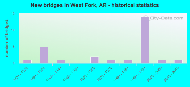
- New bridges - historical statistics
- 11920-1929
- 51930-1939
- 11940-1949
- 21960-1969
- 11970-1979
- 11980-1989
- 141990-1999
- 12000-2009
- 12010-2019
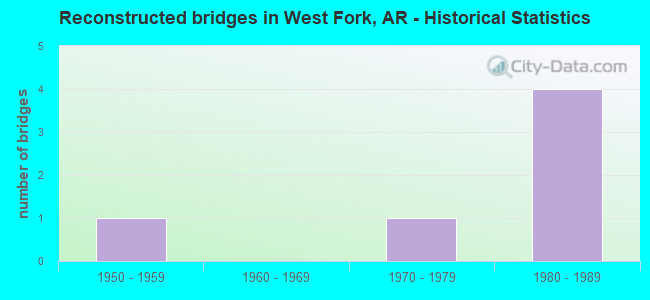
- Reconstructed bridges - Historical Statistics
- 11950-1959
- 01960-1969
- 11970-1979
- 41980-1989
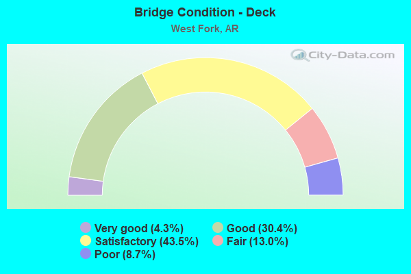
- Bridge Condition - Deck
- 4.3%Very good
- 30.4%Good
- 43.5%Satisfactory
- 13.0%Fair
- 8.7%Poor
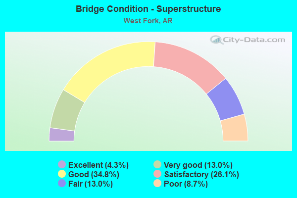
- Bridge Condition - Superstructure
- 4.3%Excellent
- 13.0%Very good
- 34.8%Good
- 26.1%Satisfactory
- 13.0%Fair
- 8.7%Poor
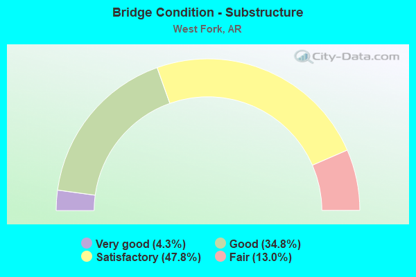
- Bridge Condition - Substructure
- 4.3%Very good
- 34.8%Good
- 47.8%Satisfactory
- 13.0%Fair
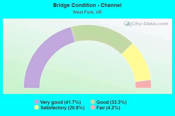
- Bridge Condition - Channel
- 41.7%Very good
- 33.3%Good
- 20.8%Satisfactory
- 4.2%Fair
Find on map >> Show street view
Structure Number: 3987, Location: 0.29 MI NW JCT US 71 &170 (Lat: 35.928511, Lng: -94.183900), Route carried "on" structure: State highway 170, Year Built: 1966, Status: Open, Structure Length: 11.06m (36.29ft), Average Daily Traffic: 4,300 (year 2018), Truck Traffic: 3%, Average Future Daily Traffic: 5,000 (year 2038), Design Load: HS 20, Features Intersected: West Fork White River
Minimum Vertical Clearance: 30+ m (98+ ft), Kilometerpoint: 0.467, Lanes on structure: 2, Owner: State Highway Agency, Approaching Roadway Width: 10.4m (34.1ft), Skew: 3 degrees, Material/Design: Steel, Design/Construction: Stringer/Multi-beam, Number Of Spans In Main Unit: 7, Length of Maximum Span: 18.3m (60.0ft), Curb or Sidewalk Widths: Left: 0.4m (1.3ft), Right: 0.4m (1.3ft), Curb-To-Curb Width: 8.5m (27.9ft), Out-to-Out Width: 10.3m (33.8ft)
Condition: Deck: Poor, Superstructure: Poor, Substructure: Fair, Channel: Satisfactory, Operating Rating: 35.4 metric tons, Method Used To Determine Operating Rating: Load Factor (LF), Inventory Rating: 21.8 metric tons, Method Used To Determine Inventory Rating: Load Factor (LF), Structural Evaluation: Meets minimum limits, Deck Geometry: Meets minimum limits, Waterway Adequacy: Equal to present desirable criteria, Approach Roadway Alignment: Better than present minimum criteria, Designated Inspection Frequency: Every 24 months, Critical Feature Inspection Frequency: Every 24 months, Other Special Inspection Frequency: Every 24 months, Inspection Date: September 2021, Other Special Inspection Date: September 2020, Deck Structure Type: Concrete Cast-file-Place, Wearing Surface/Protective System: Wearing Surface: Monolithic Concrete
Find on map >> Show street view
Structure Number: 4934, Location: 0.02 Mi W US 71 (Lat: 35.885461, Lng: -94.169581), Route carried "on" structure: County highway 35, Year Built: 2017, Status: Open, Structure Length: 10.73m (35.20ft), Average Daily Traffic: 316 (year 2018), Truck Traffic: 8%, Average Future Daily Traffic: 450 (year 2036), Design Load: HL 93, Features Intersected: West Fork White River
Minimum Vertical Clearance: 30+ m (98+ ft), Kilometerpoint: 5.359, Lanes on structure: 2, Owner: County Highway Agency, Approaching Roadway Width: 6.7m (22.0ft), Material/Design: Steel continuous, Design/Construction: Stringer/Multi-beam, Number Of Spans In Main Unit: 4, Length of Maximum Span: 29.0m (95.1ft), Curb-To-Curb Width: 8.5m (27.9ft), Out-to-Out Width: 9.9m (32.5ft)
Condition: Deck: Very good, Superstructure: Excellent, Substructure: Very good, Channel: Very good, Operating Rating: 38.1 metric tons, Method Used To Determine Operating Rating: Load and Resistance Factor (LRFR), Inventory Rating: 29.9 metric tons, Method Used To Determine Inventory Rating: Load and Resistance Factor (LRFR), Structural Evaluation: Better than present minimum criteria, Deck Geometry: Equal to present minimum criteria, Waterway Adequacy: Equal to present desirable criteria, Approach Roadway Alignment: Equal to present desirable criteria, Designated Inspection Frequency: Every 24 months, Critical Feature Inspection Frequency: Every 24 months, Inspection Date: January 2022, Deck Structure Type: Concrete Cast-file-Place, Wearing Surface/Protective System: Deck Protection: Epoxy Coated Reinforcing
Find on map >> Show street view
Structure Number: 6238, Location: 1.4 MI W OF 71 JCT (Lat: 35.924481, Lng: -94.199111), Route carried "on" structure: State highway 170, Year Built: 1994, Status: Open, Structure Length: 11.37m (37.30ft), Average Daily Traffic: 4,143 (year 2018), Truck Traffic: 3%, Average Future Daily Traffic: 6,892 (year 2028), Design Load: HS 20+Mod, Features Intersected: I 49-Washington Co.
Minimum Vertical Clearance: 30+ m (98+ ft), Kilometerpoint: 2.317, Lanes on structure: 2, Lanes under structure: 4, Base Highway Network: Yes, Owner: State Highway Agency, Approaching Roadway Width: 12.2m (40.0ft), Skew: 3 degrees, Material/Design: Steel continuous, Design/Construction: Stringer/Multi-beam, Number Of Spans In Main Unit: 4, Length of Maximum Span: 42.7m (140.1ft), Curb-To-Curb Width: 12.2m (40.0ft), Out-to-Out Width: 13.1m (43.0ft)
Condition: Deck: Good, Superstructure: Good, Substructure: Satisfactory, Operating Rating: 54.4 metric tons, Method Used To Determine Operating Rating: Load Factor (LF), Inventory Rating: 32.7 metric tons, Method Used To Determine Inventory Rating: Load Factor (LF), Structural Evaluation: Equal to present minimum criteria, Deck Geometry: Equal to present minimum criteria, Underclear: Equal to present minimum criteria, Approach Roadway Alignment: Equal to present desirable criteria, Designated Inspection Frequency: Every 24 months, Critical Feature Inspection Frequency: Every 24 months, Inspection Date: December 2021, Deck Structure Type: Concrete Cast-file-Place, Wearing Surface/Protective System: Wearing Surface: Monolithic Concrete
Find on map >> Show street view
Structure Number: 624, Location: 0.2 MI W CO RD 63 (Lat: 35.942300, Lng: -94.194839), Route carried "on" structure: County highway 47260, Year Built: 1992, Status: Open, Structure Length: 10.39m (34.09ft), Average Daily Traffic: 50 (year 2018), Truck Traffic: 1%, Average Future Daily Traffic: 60 (year 2030), Design Load: HS 20, Features Intersected: I 49-Washington Co, Facility Carried by Structure: CR 63/Campbell Rd
Minimum Vertical Clearance: 30+ m (98+ ft), Kilometerpoint: 0.322, Lanes on structure: 2, Lanes under structure: 4, Owner: State Highway Agency, Approaching Roadway Width: 9.1m (29.9ft), Skew: 1 degrees, Material/Design: Steel continuous, Design/Construction: Stringer/Multi-beam, Number Of Spans In Main Unit: 4, Length of Maximum Span: 29.9m (98.1ft), Curb-To-Curb Width: 9.1m (29.9ft), Out-to-Out Width: 10.0m (32.8ft)
Condition: Deck: Good, Superstructure: Very good, Substructure: Satisfactory, Operating Rating: 54.4 metric tons, Method Used To Determine Operating Rating: Load Factor (LF), Inventory Rating: 32.7 metric tons, Method Used To Determine Inventory Rating: Load Factor (LF), Structural Evaluation: Equal to present minimum criteria, Deck Geometry: Better than present minimum criteria, Underclear: Equal to present minimum criteria, Approach Roadway Alignment: Equal to present minimum criteria, Designated Inspection Frequency: Every 24 months, Critical Feature Inspection Frequency: Every 24 months, Inspection Date: December 2020, Deck Structure Type: Concrete Cast-file-Place, Wearing Surface/Protective System: Wearing Surface: Monolithic Concrete, Deck Protection: Bituminous
Find on map >> Show street view
Structure Number: 6241, Location: 0.02 W Jct CO RD 63 (Lat: 35.961950, Lng: -94.195800), Route carried "on" structure: County highway 65, Year Built: 1992, Status: Open, Structure Length: 7.68m (25.20ft), Average Daily Traffic: 1,356 (year 1987), Truck Traffic: 1%, Average Future Daily Traffic: 850 (year 2007), Design Load: HS 20, Features Intersected: I 49-Washington Co.
Minimum Vertical Clearance: 30+ m (98+ ft), Kilometerpoint: 28.244, Lanes on structure: 2, Lanes under structure: 4, Owner: State Highway Agency, Approaching Roadway Width: 9.1m (29.9ft), Skew: 1 degrees, Material/Design: Steel continuous, Design/Construction: Stringer/Multi-beam, Number Of Spans In Main Unit: 2, Length of Maximum Span: 38.1m (125.0ft), Curb-To-Curb Width: 9.1m (29.9ft), Out-to-Out Width: 10.0m (32.8ft)
Condition: Deck: Good, Superstructure: Very good, Substructure: Satisfactory, Operating Rating: 54.4 metric tons, Method Used To Determine Operating Rating: Load Factor (LF), Inventory Rating: 32.7 metric tons, Method Used To Determine Inventory Rating: Load Factor (LF), Structural Evaluation: Equal to present minimum criteria, Deck Geometry: Somewhat better than minimum adequacy, Underclear: Superior to present desirable criteria, Approach Roadway Alignment: Equal to present desirable criteria, Designated Inspection Frequency: Every 24 months, Critical Feature Inspection Frequency: Every 24 months, Inspection Date: December 2020, Deck Structure Type: Concrete Cast-file-Place, Wearing Surface/Protective System: Wearing Surface: Monolithic Concrete, Deck Protection: Bituminous
Find on map >> Show street view
Structure Number: 706, Location: 9.69 Mi N Hwy 74 (Lat: 35.894422, Lng: -94.174347), Route carried "on" structure: US 71, Year Built: 2009, Status: Open, Structure Length: 3.96m (12.99ft), Average Daily Traffic: 2,800 (year 2018), Truck Traffic: 3%, Average Future Daily Traffic: 3,300 (year 2038), Design Load: HS 20, Features Intersected: Mill Creek
Minimum Vertical Clearance: 30+ m (98+ ft), Kilometerpoint: 20.257, Lanes on structure: 2, Base Highway Network: Yes, Owner: State Highway Agency, Approaching Roadway Width: 12.2m (40.0ft), Skew: 2 degrees, Material/Design: Steel continuous, Design/Construction: Stringer/Multi-beam, Number Of Spans In Main Unit: 3, Length of Maximum Span: 14.6m (47.9ft), Curb-To-Curb Width: 12.2m (40.0ft), Out-to-Out Width: 13.2m (43.3ft)
Condition: Deck: Good, Superstructure: Very good, Substructure: Good, Channel: Very good, Operating Rating: 54.4 metric tons, Method Used To Determine Operating Rating: Load Factor (LF), Inventory Rating: 32.7 metric tons, Method Used To Determine Inventory Rating: Load Factor (LF), Structural Evaluation: Better than present minimum criteria, Deck Geometry: Equal to present minimum criteria, Waterway Adequacy: Superior to present desirable criteria, Approach Roadway Alignment: Equal to present desirable criteria, Designated Inspection Frequency: Every 24 months, Critical Feature Inspection Frequency: Every 24 months, Inspection Date: August 2021, Deck Structure Type: Concrete Cast-file-Place, Wearing Surface/Protective System: Wearing Surface: Monolithic Concrete, Deck Protection: Epoxy Coated Reinforcing
Find on map >> Show street view
Structure Number: 17316, Location: 1.3 MI E JCT US 71 (Lat: 35.939414, Lng: -94.153586), Route carried "on" structure: County highway 30, Year Built: 1928, Year Reconstructed: 1977, Status: Posted for load, Structure Length: 0.98m (3.22ft), Average Daily Traffic: 895 (year 2018), Truck Traffic: 1%, Average Future Daily Traffic: 1,000 (year 2038), Features Intersected: Dye Creek-Washington Co., Facility Carried by Structure: Mineral Springs Rd
Minimum Vertical Clearance: 30+ m (98+ ft), Kilometerpoint: 6.387, Lanes on structure: 2, Owner: County Highway Agency, Approaching Roadway Width: 6.1m (20.0ft), Skew: 1 degrees, Material/Design: Steel, Design/Construction: Stringer/Multi-beam, Number Of Spans In Main Unit: 1, Length of Maximum Span: 8.5m (27.9ft), Curb-To-Curb Width: 7.9m (25.9ft), Out-to-Out Width: 7.9m (25.9ft)
Condition: Deck: Satisfactory, Superstructure: Satisfactory, Substructure: Satisfactory, Channel: Good, Operating Rating: 31.1 metric tons, Method Used To Determine Operating Rating: Load Factor (LF), Inventory Rating: 18.7 metric tons, Method Used To Determine Inventory Rating: Load Factor (LF), Structural Evaluation: Somewhat better than minimum adequacy, Deck Geometry: Somewhat better than minimum adequacy, Waterway Adequacy: Better than present minimum criteria, Approach Roadway Alignment: High priority of corrective action, Bridge Posting: Required (Relationship of Operating Rating to Maximum Legal Load: 20.0 - 29.9% below), Length Of Structure Improvement: 0.98m (3.22ft), Designated Inspection Frequency: Every 24 months, Critical Feature Inspection Frequency: Every 24 months, Inspection Date: January 2022, Total Project Cost: $36,000, Deck Structure Type: Concrete Cast-file-Place, Wearing Surface/Protective System: Wearing Surface: Bituminous
Find on map >> Show street view
Structure Number: 17319, Location: 1.02MI SO OF SH 170 (Lat: 35.911597, Lng: -94.184539), Route carried "on" structure: City street 37550, Year Built: 1940, Status: Posted for load, Structure Length: 0.98m (3.22ft), Average Daily Traffic: 60 (year 2018), Truck Traffic: 1%, Average Future Daily Traffic: 477 (year 2007), Design Load: H 10, Features Intersected: Creek-Washington Co., Facility Carried by Structure: McKnight Street
Minimum Vertical Clearance: 30+ m (98+ ft), Kilometerpoint: 1.642, Lanes on structure: 2, Owner: City or Municipal Highway Agency, Approaching Roadway Width: 6.7m (22.0ft), Material/Design: Steel, Design/Construction: Stringer/Multi-beam, Number Of Spans In Main Unit: 1, Length of Maximum Span: 9.1m (29.9ft), Curb-To-Curb Width: 7.1m (23.3ft), Out-to-Out Width: 7.1m (23.3ft)
Condition: Deck: Fair, Superstructure: Fair, Substructure: Satisfactory, Channel: Good, Operating Rating: 21.8 metric tons, Method Used To Determine Operating Rating: Allowable Stress (AS), Inventory Rating: 12.7 metric tons, Method Used To Determine Inventory Rating: Allowable Stress (AS), Structural Evaluation: Meets minimum limits, Deck Geometry: Somewhat better than minimum adequacy, Waterway Adequacy: Equal to present minimum criteria, Approach Roadway Alignment: Equal to present minimum criteria, Bridge Posting: Required (Relationship of Operating Rating to Maximum Legal Load: > 39.9% below), Length Of Structure Improvement: 0.98m (3.22ft), Designated Inspection Frequency: Every 24 months, Critical Feature Inspection Frequency: Every 24 months, Inspection Date: January 2022, Total Project Cost: $33,000, Deck Structure Type: Concrete Cast-file-Place, Wearing Surface/Protective System: Wearing Surface: Bituminous
Find on map >> Show street view
Structure Number: 17343, Location: 1MI N OF WEST FORK (Lat: 35.939442, Lng: -94.190750), Route carried "on" structure: County highway 63, Year Built: 1967, Status: Posted for load, Structure Length: 2.44m (8.01ft), Average Daily Traffic: 170 (year 2018), Truck Traffic: 1%, Average Future Daily Traffic: 850 (year 2007), Design Load: H 15, Features Intersected: Lee Branch - Wash. Co., Facility Carried by Structure: SE Campbell Road
Minimum Vertical Clearance: 30+ m (98+ ft), Kilometerpoint: 7.128, Lanes on structure: 2, Owner: County Highway Agency, Approaching Roadway Width: 6.7m (22.0ft), Material/Design: Steel continuous, Design/Construction: Stringer/Multi-beam, Number Of Spans In Main Unit: 4, Length of Maximum Span: 6.1m (20.0ft), Curb or Sidewalk Widths: Left: 0.2m (0.7ft), Right: 0.2m (0.7ft), Curb-To-Curb Width: 5.7m (18.7ft), Out-to-Out Width: 6.1m (20.0ft)
Condition: Deck: Fair, Superstructure: Good, Substructure: Good, Channel: Good, Operating Rating: 28.1 metric tons, Method Used To Determine Operating Rating: Load Factor (LF), Inventory Rating: 17.2 metric tons, Method Used To Determine Inventory Rating: Load Factor (LF), Structural Evaluation: Somewhat better than minimum adequacy, Deck Geometry: High priority of corrective action, Waterway Adequacy: Better than present minimum criteria, Approach Roadway Alignment: Meets minimum limits, Bridge Posting: Required (Relationship of Operating Rating to Maximum Legal Load: 10.0 - 19.9% below), Length Of Structure Improvement: 3.23m (10.60ft), Designated Inspection Frequency: Every 24 months, Inspection Date: August 2021, Roadway Improvement Cost: $109,000, Total Project Cost: $289,000, Deck Structure Type: Concrete Cast-file-Place, Wearing Surface/Protective System: Wearing Surface: Monolithic Concrete
Find on map >> Show street view
Structure Number: 2073, Location: 0.160 MI E CO RD 30 (Lat: 35.932917, Lng: -94.125792), Route carried "on" structure: County highway 100, Year Built: 1988, Status: Open, Structure Length: 1.04m (3.41ft), Average Daily Traffic: 1,347 (year 2018), Truck Traffic: 1%, Average Future Daily Traffic: 59 (year 2007), Features Intersected: Creek - Wash. Co., Facility Carried by Structure: Low Gap Road
Minimum Vertical Clearance: 30+ m (98+ ft), Kilometerpoint: 10.763, Lanes on structure: 2, Owner: County Highway Agency, Approaching Roadway Width: 8.5m (27.9ft), Skew: 2 degrees, Material/Design: Concrete, Design/Construction: Channel Beam, Number Of Spans In Main Unit: 1, Length of Maximum Span: 8.8m (28.9ft), Curb-To-Curb Width: 7.7m (25.3ft), Out-to-Out Width: 7.8m (25.6ft)
Condition: Deck: Good, Superstructure: Good, Substructure: Good, Channel: Good, Operating Rating: 44.5 metric tons, Method Used To Determine Operating Rating: Allowable Stress (AS), Inventory Rating: 26.3 metric tons, Method Used To Determine Inventory Rating: Allowable Stress (AS), Structural Evaluation: Equal to present minimum criteria, Deck Geometry: Meets minimum limits, Waterway Adequacy: Better than present minimum criteria, Approach Roadway Alignment: Equal to present minimum criteria, Designated Inspection Frequency: Every 24 months, Critical Feature Inspection Frequency: Every 24 months, Inspection Date: September 2020, Deck Structure Type: Concrete Precast Panels, Wearing Surface/Protective System: Wearing Surface: Monolithic Concrete
Find on map >> Show street view
Structure Number: 21463, Location: 2.0 MI N. CO RD 237 (Lat: 35.888247, Lng: -94.210028), Route carried "on" structure: County highway 224, Year Built: 1993, Status: Open, Structure Length: 1.83m (6.00ft), Average Daily Traffic: 481 (year 2018), Truck Traffic: 1%, Average Future Daily Traffic: 200 (year 2007), Design Load: H 15, Features Intersected: Lee Creek - Wash. Co., Facility Carried by Structure: Union Star Road
Minimum Vertical Clearance: 30+ m (98+ ft), Kilometerpoint: 3.219, Lanes on structure: 2, Owner: County Highway Agency, Approaching Roadway Width: 7.6m (24.9ft), Material/Design: Concrete, Design/Construction: Channel Beam, Number Of Spans In Main Unit: 2, Length of Maximum Span: 9.1m (29.9ft), Curb-To-Curb Width: 7.8m (25.6ft), Out-to-Out Width: 8.7m (28.5ft)
Condition: Deck: Satisfactory, Superstructure: Satisfactory, Substructure: Satisfactory, Channel: Very good, Operating Rating: 47.2 metric tons, Method Used To Determine Operating Rating: Load Factor (LF), Inventory Rating: 29.0 metric tons, Method Used To Determine Inventory Rating: Load Factor (LF), Structural Evaluation: Equal to present minimum criteria, Deck Geometry: Meets minimum limits, Waterway Adequacy: Superior to present desirable criteria, Approach Roadway Alignment: Equal to present minimum criteria, Designated Inspection Frequency: Every 24 months, Critical Feature Inspection Frequency: Every 24 months, Inspection Date: November 2020, Deck Structure Type: Concrete Precast Panels, Wearing Surface/Protective System: Wearing Surface: Monolithic Concrete
Find on map >> Show street view
Structure Number: A1424, Location: 2.3 MI N JCT SH 170 (Lat: 35.962508, Lng: -94.167589), Route carried "on" structure: US 71, Year Built: 1930, Year Reconstructed: 1980, Status: Open, Structure Length: 3.20m (10.50ft), Average Daily Traffic: 5,800 (year 2018), Truck Traffic: 3%, Average Future Daily Traffic: 8,861 (year 2028), Design Load: HS 20, Features Intersected: Rock Creek
Minimum Vertical Clearance: 30+ m (98+ ft), Kilometerpoint: 28.221, Lanes on structure: 4, Base Highway Network: Yes, Owner: State Highway Agency, Approaching Roadway Width: 17.1m (56.1ft), Material/Design: Concrete, Design/Construction: Tee Beam, Number Of Spans In Main Unit: 3, Length of Maximum Span: 10.7m (35.1ft), Curb-To-Curb Width: 17.1m (56.1ft), Out-to-Out Width: 17.9m (58.7ft)
Condition: Deck: Poor, Superstructure: Poor, Substructure: Fair, Channel: Fair, Operating Rating: 46.3 metric tons, Method Used To Determine Operating Rating: Load Factor (LF), Inventory Rating: 27.2 metric tons, Method Used To Determine Inventory Rating: Load Factor (LF), Structural Evaluation: Meets minimum limits, Deck Geometry: Somewhat better than minimum adequacy, Waterway Adequacy: Equal to present desirable criteria, Approach Roadway Alignment: Equal to present desirable criteria, Length Of Structure Improvement: 3.20m (10.50ft), Designated Inspection Frequency: Every 24 months, Critical Feature Inspection Frequency: Every 24 months, Other Special Inspection Frequency: Every 24 months, Inspection Date: April 2021, Other Special Inspection Date: June 2020, Total Project Cost: $277,000, Deck Structure Type: Concrete Cast-file-Place, Wearing Surface/Protective System: Wearing Surface: Monolithic Concrete
Find on map >> Show street view
Structure Number: A1425, Location: 0.72 MI N JCT SH 170 (Lat: 35.941878, Lng: -94.178728), Route carried "on" structure: US 71, Year Built: 1930, Year Reconstructed: 1980, Status: Open, Structure Length: 2.26m (7.41ft), Average Daily Traffic: 5,800 (year 2018), Truck Traffic: 3%, Average Future Daily Traffic: 7,876 (year 2028), Design Load: HS 20, Features Intersected: Dye Creek - Wash. Co.
Minimum Vertical Clearance: 30+ m (98+ ft), Kilometerpoint: 25.680, Lanes on structure: 5, Base Highway Network: Yes, Owner: State Highway Agency, Approaching Roadway Width: 17.1m (56.1ft), Material/Design: Concrete, Design/Construction: Tee Beam, Number Of Spans In Main Unit: 2, Length of Maximum Span: 11.3m (37.1ft), Curb-To-Curb Width: 17.1m (56.1ft), Out-to-Out Width: 17.9m (58.7ft)
Condition: Deck: Fair, Superstructure: Fair, Substructure: Fair, Channel: Satisfactory, Operating Rating: 43.5 metric tons, Method Used To Determine Operating Rating: Load Factor (LF), Inventory Rating: 26.3 metric tons, Method Used To Determine Inventory Rating: Load Factor (LF), Structural Evaluation: Somewhat better than minimum adequacy, Deck Geometry: High priority of replacement, Waterway Adequacy: Equal to present desirable criteria, Approach Roadway Alignment: Equal to present desirable criteria, Length Of Structure Improvement: 3.05m (10.01ft), Designated Inspection Frequency: Every 24 months, Critical Feature Inspection Frequency: Every 24 months, Inspection Date: November 2020, Roadway Improvement Cost: $265,000, Total Project Cost: $688,000, Deck Structure Type: Concrete Cast-file-Place, Wearing Surface/Protective System: Wearing Surface: Integral Concrete
Find on map >> Show street view
Structure Number: A6237, Location: 11.4 MI N. OF WASH.CO.LN (Lat: 35.905711, Lng: -94.193019), Route carried "on" structure: Interstate 49, Year Built: 1994, Status: Open, Structure Length: 26.88m (88.19ft), Average Daily Traffic: 2,399 (year 2018), Truck Traffic: 1%, Average Future Daily Traffic: 11,252 (year 2028), Design Load: HS 20+Mod, Features Intersected: Ravine-Washington Co.
Minimum Vertical Clearance: 30+ m (98+ ft), Kilometerpoint: 82.801, Lanes on structure: 2, Base Highway Network: Yes, Owner: State Highway Agency, Approaching Roadway Width: 12.2m (40.0ft), Material/Design: Steel continuous, Design/Construction: Stringer/Multi-beam, Number Of Spans In Main Unit: 6, Length of Maximum Span: 48.8m (160.1ft), Curb-To-Curb Width: 12.2m (40.0ft), Out-to-Out Width: 13.0m (42.7ft)
Condition: Deck: Good, Superstructure: Satisfactory, Substructure: Good, Channel: Very good, Operating Rating: 54.4 metric tons, Method Used To Determine Operating Rating: Load Factor (LF), Inventory Rating: 32.7 metric tons, Method Used To Determine Inventory Rating: Load Factor (LF), Structural Evaluation: Equal to present minimum criteria, Deck Geometry: Better than present minimum criteria, Waterway Adequacy: Superior to present desirable criteria, Approach Roadway Alignment: Equal to present desirable criteria, Designated Inspection Frequency: Every 24 months, Critical Feature Inspection Frequency: Every 24 months, Inspection Date: October 2020, Deck Structure Type: Concrete Cast-file-Place, Wearing Surface/Protective System: Wearing Surface: Monolithic Concrete, Deck Protection: Epoxy Coated Reinforcing
Find on map >> Show street view
Structure Number: A6239, Location: 0.76 MI N EXIT 53 (Lat: 35.937839, Lng: -94.195758), Route carried "on" structure: Interstate 49, Year Built: 1994, Status: Open, Structure Length: 8.41m (27.59ft), Average Daily Traffic: 11,500 (year 2018), Truck Traffic: 1%, Average Future Daily Traffic: 13,361 (year 2028), Design Load: HS 20+Mod, Features Intersected: Farm Road - Wash. Co.
Minimum Vertical Clearance: 30+ m (98+ ft), Kilometerpoint: 86.518, Lanes on structure: 2, Lanes under structure: 4, Base Highway Network: Yes, Owner: State Highway Agency, Approaching Roadway Width: 12.2m (40.0ft), Skew: 5 degrees, Material/Design: Steel continuous, Design/Construction: Stringer/Multi-beam, Number Of Spans In Main Unit: 4, Length of Maximum Span: 25.0m (82.0ft), Curb-To-Curb Width: 12.2m (40.0ft), Out-to-Out Width: 13.1m (43.0ft)
Condition: Deck: Satisfactory, Superstructure: Good, Substructure: Satisfactory, Channel: Good, Operating Rating: 54.4 metric tons, Method Used To Determine Operating Rating: Load Factor (LF), Inventory Rating: 32.7 metric tons, Method Used To Determine Inventory Rating: Load Factor (LF), Structural Evaluation: Equal to present minimum criteria, Deck Geometry: Better than present minimum criteria, Underclear: Superior to present desirable criteria, Waterway Adequacy: Superior to present desirable criteria, Approach Roadway Alignment: Equal to present desirable criteria, Designated Inspection Frequency: Every 24 months, Critical Feature Inspection Frequency: Every 24 months, Inspection Date: March 2021, Deck Structure Type: Concrete Cast-file-Place, Wearing Surface/Protective System: Wearing Surface: Monolithic Concrete, Membrane: Built-up
Find on map >> Show street view
Structure Number: A6483, Location: 2.32 MI. S. SH 170 (Lat: 35.848839, Lng: -94.183478), Route carried "on" structure: Interstate 49, Year Built: 1997, Status: Open, Structure Length: 9.08m (29.79ft), Average Daily Traffic: 2,300 (year 2018), Truck Traffic: 1%, Average Future Daily Traffic: 11,252 (year 2028), Design Load: HS 20+Mod, Features Intersected: Riley Creek - Wash. Co.
Minimum Vertical Clearance: 30+ m (98+ ft), Kilometerpoint: 75.977, Lanes on structure: 2, Base Highway Network: Yes, Owner: State Highway Agency, Approaching Roadway Width: 12.2m (40.0ft), Material/Design: Steel continuous, Design/Construction: Stringer/Multi-beam, Number Of Spans In Main Unit: 3, Length of Maximum Span: 32.0m (105.0ft), Curb-To-Curb Width: 12.2m (40.0ft), Out-to-Out Width: 13.1m (43.0ft)
Condition: Deck: Satisfactory, Superstructure: Good, Substructure: Good, Channel: Very good, Operating Rating: 54.4 metric tons, Method Used To Determine Operating Rating: Load Factor (LF), Inventory Rating: 32.7 metric tons, Method Used To Determine Inventory Rating: Load Factor (LF), Structural Evaluation: Better than present minimum criteria, Deck Geometry: Better than present minimum criteria, Waterway Adequacy: Superior to present desirable criteria, Approach Roadway Alignment: Equal to present desirable criteria, Designated Inspection Frequency: Every 24 months, Critical Feature Inspection Frequency: Every 24 months, Inspection Date: March 2020, Deck Structure Type: Concrete Cast-file-Place, Wearing Surface/Protective System: Wearing Surface: Monolithic Concrete, Deck Protection: Epoxy Coated Reinforcing
Find on map >> Show street view
Structure Number: A6484, Location: 5.2 MI S. SH 170 (Lat: 35.853039, Lng: -94.181050), Route carried "on" structure: Interstate 49, Year Built: 1997, Status: Open, Structure Length: 40.29m (132.19ft), Average Daily Traffic: 2,300 (year 2018), Truck Traffic: 1%, Average Future Daily Traffic: 11,252 (year 2028), Design Load: HS 20+Mod, Features Intersected: Winn Crk / CR 228
Minimum Vertical Clearance: 30+ m (98+ ft), Kilometerpoint: 76.557, Lanes on structure: 2, Lanes under structure: 2, Base Highway Network: Yes, Owner: State Highway Agency, Approaching Roadway Width: 12.2m (40.0ft), Material/Design: Steel continuous, Design/Construction: Stringer/Multi-beam, Number Of Spans In Main Unit: 8, Length of Maximum Span: 70.1m (230.0ft), Curb-To-Curb Width: 12.2m (40.0ft), Out-to-Out Width: 13.1m (43.0ft)
Condition: Deck: Satisfactory, Superstructure: Satisfactory, Substructure: Good, Channel: Very good, Operating Rating: 54.4 metric tons, Method Used To Determine Operating Rating: Load Factor (LF), Inventory Rating: 32.7 metric tons, Method Used To Determine Inventory Rating: Load Factor (LF), Structural Evaluation: Equal to present minimum criteria, Deck Geometry: Better than present minimum criteria, Underclear: Equal to present minimum criteria, Waterway Adequacy: Superior to present desirable criteria, Approach Roadway Alignment: Equal to present desirable criteria, Designated Inspection Frequency: Every 24 months, Critical Feature Inspection Frequency: Every 24 months, Inspection Date: April 2020, Deck Structure Type: Concrete Cast-file-Place, Wearing Surface/Protective System: Wearing Surface: Monolithic Concrete, Deck Protection: Epoxy Coated Reinforcing
Find on map >> Show street view
Structure Number: A6485, Location: 3.95 MI S. SH 170 (Lat: 35.870761, Lng: -94.178131), Route carried "on" structure: Interstate 49, Year Built: 1997, Status: Open, Structure Length: 25.66m (84.19ft), Average Daily Traffic: 19,500 (year 2018), Truck Traffic: 1%, Average Future Daily Traffic: 11,252 (year 2028), Design Load: HS 20+Mod, Features Intersected: Boyd Hollow Access Road
Minimum Vertical Clearance: 30+ m (98+ ft), Kilometerpoint: 78.568, Lanes on structure: 2, Lanes under structure: 2, Base Highway Network: Yes, Owner: State Highway Agency, Approaching Roadway Width: 12.2m (40.0ft), Material/Design: Steel continuous, Design/Construction: Stringer/Multi-beam, Number Of Spans In Main Unit: 6, Length of Maximum Span: 42.7m (140.1ft), Curb-To-Curb Width: 12.2m (40.0ft), Out-to-Out Width: 13.1m (43.0ft)
Condition: Deck: Satisfactory, Superstructure: Satisfactory, Substructure: Satisfactory, Channel: Very good, Operating Rating: 54.4 metric tons, Method Used To Determine Operating Rating: Load Factor (LF), Inventory Rating: 32.7 metric tons, Method Used To Determine Inventory Rating: Load Factor (LF), Structural Evaluation: Equal to present minimum criteria, Deck Geometry: Better than present minimum criteria, Underclear: Somewhat better than minimum adequacy, Waterway Adequacy: Superior to present desirable criteria, Approach Roadway Alignment: Equal to present desirable criteria, Designated Inspection Frequency: Every 24 months, Critical Feature Inspection Frequency: Every 24 months, Inspection Date: April 2020, Deck Structure Type: Concrete Cast-file-Place, Wearing Surface/Protective System: Wearing Surface: Monolithic Concrete, Deck Protection: Epoxy Coated Reinforcing
Find on map >> Show street view
Structure Number: B6237, Location: 11.4 N. OF WASH CO LINE (Lat: 35.905947, Lng: -94.192308), Route carried "on" structure: Interstate 49, Year Built: 1998, Status: Open, Structure Length: 31.15m (102.20ft), Average Daily Traffic: 2,399 (year 2018), Truck Traffic: 1%, Average Future Daily Traffic: 11,252 (year 2028), Design Load: HS 20+Mod, Features Intersected: Ravine-Washington Co.
Minimum Vertical Clearance: 30+ m (98+ ft), Kilometerpoint: 82.801, Lanes on structure: 2, Base Highway Network: Yes, Owner: State Highway Agency, Approaching Roadway Width: 12.2m (40.0ft), Material/Design: Steel continuous, Design/Construction: Stringer/Multi-beam, Number Of Spans In Main Unit: 7, Length of Maximum Span: 48.8m (160.1ft), Curb-To-Curb Width: 12.2m (40.0ft), Out-to-Out Width: 13.0m (42.7ft)
Condition: Deck: Satisfactory, Superstructure: Good, Substructure: Good, Channel: Very good, Operating Rating: 54.4 metric tons, Method Used To Determine Operating Rating: Load Factor (LF), Inventory Rating: 32.7 metric tons, Method Used To Determine Inventory Rating: Load Factor (LF), Structural Evaluation: Better than present minimum criteria, Deck Geometry: Better than present minimum criteria, Waterway Adequacy: Superior to present desirable criteria, Approach Roadway Alignment: Equal to present desirable criteria, Designated Inspection Frequency: Every 24 months, Critical Feature Inspection Frequency: Every 24 months, Inspection Date: October 2020, Deck Structure Type: Concrete Cast-file-Place, Wearing Surface/Protective System: Wearing Surface: Monolithic Concrete, Deck Protection: Epoxy Coated Reinforcing
Find on map >> Show street view
Structure Number: B6239, Location: 0.76 MI N OF EXIT 53 (Lat: 35.937939, Lng: -94.195378), Route carried "on" structure: Interstate 49, Year Built: 1994, Status: Open, Structure Length: 8.41m (27.59ft), Average Daily Traffic: 11,500 (year 2018), Truck Traffic: 1%, Average Future Daily Traffic: 13,361 (year 2028), Design Load: HS 20+Mod, Features Intersected: Farm Road - Wash. Co.
Minimum Vertical Clearance: 30+ m (98+ ft), Kilometerpoint: 86.518, Lanes on structure: 2, Lanes under structure: 4, Base Highway Network: Yes, Owner: State Highway Agency, Approaching Roadway Width: 12.2m (40.0ft), Skew: 5 degrees, Material/Design: Steel continuous, Design/Construction: Stringer/Multi-beam, Number Of Spans In Main Unit: 4, Length of Maximum Span: 25.0m (82.0ft), Curb-To-Curb Width: 12.2m (40.0ft), Out-to-Out Width: 13.1m (43.0ft)
Condition: Deck: Satisfactory, Superstructure: Good, Substructure: Satisfactory, Channel: Good, Operating Rating: 54.4 metric tons, Method Used To Determine Operating Rating: Load Factor (LF), Inventory Rating: 32.7 metric tons, Method Used To Determine Inventory Rating: Load Factor (LF), Structural Evaluation: Equal to present minimum criteria, Deck Geometry: Better than present minimum criteria, Underclear: Superior to present desirable criteria, Waterway Adequacy: Superior to present desirable criteria, Approach Roadway Alignment: Equal to present desirable criteria, Designated Inspection Frequency: Every 24 months, Critical Feature Inspection Frequency: Every 24 months, Inspection Date: March 2021, Deck Structure Type: Concrete Cast-file-Place
Find on map >> Show street view
Structure Number: B6483, Location: 2.32 MI. S SH 170 (Lat: 35.848539, Lng: -94.183069), Route carried "on" structure: Interstate 49, Year Built: 1997, Status: Open, Structure Length: 12.28m (40.29ft), Average Daily Traffic: 2,300 (year 2018), Truck Traffic: 1%, Average Future Daily Traffic: 11,252 (year 2028), Design Load: HS 20+Mod, Features Intersected: Riley Creek - Wash. Co.
Minimum Vertical Clearance: 30+ m (98+ ft), Kilometerpoint: 75.977, Lanes on structure: 2, Base Highway Network: Yes, Owner: State Highway Agency, Approaching Roadway Width: 12.2m (40.0ft), Material/Design: Steel continuous, Design/Construction: Stringer/Multi-beam, Number Of Spans In Main Unit: 3, Length of Maximum Span: 42.7m (140.1ft), Curb-To-Curb Width: 12.2m (40.0ft), Out-to-Out Width: 13.0m (42.7ft)
Condition: Deck: Good, Superstructure: Good, Substructure: Satisfactory, Channel: Very good, Operating Rating: 54.4 metric tons, Method Used To Determine Operating Rating: Load Factor (LF), Inventory Rating: 32.7 metric tons, Method Used To Determine Inventory Rating: Load Factor (LF), Structural Evaluation: Equal to present minimum criteria, Deck Geometry: Better than present minimum criteria, Waterway Adequacy: Superior to present desirable criteria, Approach Roadway Alignment: Equal to present desirable criteria, Designated Inspection Frequency: Every 24 months, Critical Feature Inspection Frequency: Every 24 months, Inspection Date: March 2020, Deck Structure Type: Concrete Cast-file-Place, Wearing Surface/Protective System: Wearing Surface: Monolithic Concrete, Deck Protection: Epoxy Coated Reinforcing
Find on map >> Show street view
Structure Number: B6484, Location: 5.2 MI. S. SH 170 (Lat: 35.853150, Lng: -94.180400), Route carried "on" structure: Interstate 49, Year Built: 1997, Status: Open, Structure Length: 41.67m (136.71ft), Average Daily Traffic: 2,300 (year 2018), Truck Traffic: 1%, Average Future Daily Traffic: 11,252 (year 2028), Design Load: HS 20+Mod, Features Intersected: Winn Creek / CoRd 228
Minimum Vertical Clearance: 30+ m (98+ ft), Kilometerpoint: 76.557, Lanes on structure: 2, Lanes under structure: 1, Base Highway Network: Yes, Owner: State Highway Agency, Approaching Roadway Width: 12.2m (40.0ft), Material/Design: Steel continuous, Design/Construction: Stringer/Multi-beam, Number Of Spans In Main Unit: 8, Length of Maximum Span: 70.1m (230.0ft), Curb-To-Curb Width: 12.2m (40.0ft), Out-to-Out Width: 13.0m (42.7ft)
Condition: Deck: Satisfactory, Superstructure: Satisfactory, Substructure: Good, Channel: Good, Operating Rating: 54.4 metric tons, Method Used To Determine Operating Rating: Load Factor (LF), Inventory Rating: 32.7 metric tons, Method Used To Determine Inventory Rating: Load Factor (LF), Structural Evaluation: Equal to present minimum criteria, Deck Geometry: Better than present minimum criteria, Underclear: Equal to present minimum criteria, Waterway Adequacy: Superior to present desirable criteria, Approach Roadway Alignment: Equal to present desirable criteria, Designated Inspection Frequency: Every 24 months, Critical Feature Inspection Frequency: Every 24 months, Inspection Date: May 2020, Deck Structure Type: Concrete Cast-file-Place, Wearing Surface/Protective System: Wearing Surface: Monolithic Concrete, Deck Protection: Epoxy Coated Reinforcing
Find on map >> Show street view
Structure Number: B6485, Location: 3.95 MI S. SH 170 (Lat: 35.870731, Lng: -94.177369), Route carried "on" structure: Interstate 49, Year Built: 1997, Status: Open, Structure Length: 23.84m (78.22ft), Average Daily Traffic: 19,500 (year 2018), Truck Traffic: 1%, Average Future Daily Traffic: 11,252 (year 2028), Design Load: HS 20+Mod, Features Intersected: Boyd Hollow Access Road
Minimum Vertical Clearance: 30+ m (98+ ft), Kilometerpoint: 78.568, Lanes on structure: 2, Lanes under structure: 2, Base Highway Network: Yes, Owner: State Highway Agency, Approaching Roadway Width: 12.2m (40.0ft), Material/Design: Steel continuous, Design/Construction: Stringer/Multi-beam, Number Of Spans In Main Unit: 6, Length of Maximum Span: 39.6m (129.9ft), Curb-To-Curb Width: 12.2m (40.0ft), Out-to-Out Width: 13.0m (42.7ft)
Condition: Deck: Satisfactory, Superstructure: Fair, Substructure: Satisfactory, Channel: Very good, Operating Rating: 54.4 metric tons, Method Used To Determine Operating Rating: Load Factor (LF), Inventory Rating: 32.7 metric tons, Method Used To Determine Inventory Rating: Load Factor (LF), Structural Evaluation: Somewhat better than minimum adequacy, Deck Geometry: Better than present minimum criteria, Underclear: Better than present minimum criteria, Waterway Adequacy: Superior to present desirable criteria, Approach Roadway Alignment: Equal to present desirable criteria, Designated Inspection Frequency: Every 24 months, Critical Feature Inspection Frequency: Every 24 months, Inspection Date: May 2020, Deck Structure Type: Concrete Cast-file-Place, Wearing Surface/Protective System: Wearing Surface: Monolithic Concrete, Deck Protection: Epoxy Coated Reinforcing
Find on map >> Show street view
Structure Number: M1382, Location: 8.09 MI NE OF SH 74 (Lat: 35.877281, Lng: -94.157561), Route carried "on" structure: US 71, Year Built: 1930, Year Reconstructed: 1964, Status: Open, Structure Length: 0.67m (2.20ft), Average Daily Traffic: 2,800 (year 2018), Truck Traffic: 5%, Average Future Daily Traffic: 3,938 (year 2028), Features Intersected: Ditch
Minimum Vertical Clearance: 30+ m (98+ ft), Kilometerpoint: 17.683, Lanes on structure: 2, Base Highway Network: Yes, Owner: State Highway Agency, Approaching Roadway Width: 12.2m (40.0ft), Material/Design: Concrete, Design/Construction: Culvert, Number Of Spans In Main Unit: 2, Length of Maximum Span: 3.4m (11.2ft)
Condition: Channel: Satisfactory, Culverts: Satisfactory, Operating Rating: 39.0 metric tons, Method Used To Determine Operating Rating: Load Factor (LF), Inventory Rating: 23.6 metric tons, Method Used To Determine Inventory Rating: Load Factor (LF), Structural Evaluation: Equal to present minimum criteria, Waterway Adequacy: Equal to present desirable criteria, Approach Roadway Alignment: Equal to present desirable criteria, Designated Inspection Frequency: Every 24 months, Critical Feature Inspection Frequency: Every 24 months, Inspection Date: August 2021
Find on map >> Show street view
Structure Number: M1383, Location: 11.25 MI NE OF SH 74 (Lat: 35.931650, Lng: -94.180031), Route carried "on" structure: US 71, Year Built: 1930, Year Reconstructed: 1987, Status: Open, Structure Length: 0.64m (2.10ft), Average Daily Traffic: 5,800 (year 2018), Truck Traffic: 3%, Average Future Daily Traffic: 7,876 (year 2028), Features Intersected: Ditch
Minimum Vertical Clearance: 30+ m (98+ ft), Kilometerpoint: 24.554, Lanes on structure: 5, Base Highway Network: Yes, Owner: State Highway Agency, Approaching Roadway Width: 16.5m (54.1ft), Material/Design: Concrete, Design/Construction: Culvert, Number Of Spans In Main Unit: 2, Length of Maximum Span: 3.4m (11.2ft)
Condition: Channel: Satisfactory, Culverts: Satisfactory, Operating Rating: 26.3 metric tons, Method Used To Determine Operating Rating: Load Factor (LF), Inventory Rating: 16.3 metric tons, Method Used To Determine Inventory Rating: Load Factor (LF), Structural Evaluation: Meets minimum limits, Waterway Adequacy: Equal to present minimum criteria, Approach Roadway Alignment: Equal to present desirable criteria, Designated Inspection Frequency: Every 24 months, Critical Feature Inspection Frequency: Every 24 months, Inspection Date: July 2021
Find on map >> Show street view
Structure Number: M1384, Location: 4.75 MI SE SH 265 (Lat: 35.972778, Lng: -94.165872), Route carried "on" structure: US 71, Year Built: 1930, Year Reconstructed: 1987, Status: Open, Structure Length: 0.67m (2.20ft), Average Daily Traffic: 5,800 (year 2018), Truck Traffic: 3%, Average Future Daily Traffic: 8,861 (year 2028), Features Intersected: Ditch
Minimum Vertical Clearance: 30+ m (98+ ft), Kilometerpoint: 29.380, Lanes on structure: 4, Base Highway Network: Yes, Owner: State Highway Agency, Approaching Roadway Width: 17.1m (56.1ft), Material/Design: Concrete, Design/Construction: Culvert, Number Of Spans In Main Unit: 2, Length of Maximum Span: 3.4m (11.2ft)
Condition: Channel: Good, Culverts: Satisfactory, Operating Rating: 26.3 metric tons, Method Used To Determine Operating Rating: Load Factor (LF), Inventory Rating: 16.3 metric tons, Method Used To Determine Inventory Rating: Load Factor (LF), Structural Evaluation: Meets minimum limits, Waterway Adequacy: Equal to present minimum criteria, Approach Roadway Alignment: Equal to present desirable criteria, Designated Inspection Frequency: Every 24 months, Critical Feature Inspection Frequency: Every 24 months, Inspection Date: July 2021
Find on map >> Show street view
Structure Number: X0248, Location: 2 MI W OF WEST FORK (Lat: 35.916900, Lng: -94.213661), Route carried "on" structure: State highway 156, Year Built: 1972, Status: Open, Structure Length: 0.79m (2.59ft), Average Daily Traffic: 1,200 (year 2018), Truck Traffic: 6%, Average Future Daily Traffic: 1,097 (year 2028), Design Load: H 20, Features Intersected: Debra Creek-Washington
Minimum Vertical Clearance: 30+ m (98+ ft), Kilometerpoint: 5.520, Lanes on structure: 2, Owner: State Highway Agency, Approaching Roadway Width: 5.8m (19.0ft), Material/Design: Concrete, Design/Construction: Culvert, Number Of Spans In Main Unit: 3, Length of Maximum Span: 2.4m (7.9ft), Curb-To-Curb Width: 7.9m (25.9ft), Out-to-Out Width: 8.5m (27.9ft)
Condition: Channel: Satisfactory, Culverts: Satisfactory, Operating Rating: 54.4 metric tons, Method Used To Determine Operating Rating: Load Factor (LF), Inventory Rating: 32.7 metric tons, Method Used To Determine Inventory Rating: Load Factor (LF), Structural Evaluation: Equal to present minimum criteria, Deck Geometry: Meets minimum limits, Waterway Adequacy: Equal to present minimum criteria, Approach Roadway Alignment: Better than present minimum criteria, Designated Inspection Frequency: Every 24 months, Critical Feature Inspection Frequency: Every 24 months, Inspection Date: August 2021, Wearing Surface/Protective System: Wearing Surface: Bituminous
Find on map >> Show street view
Structure Number: 6238, Location: 1.4 MI W OF 71 JCT (Lat: 35.924481, Lng: -94.199111), Route carried "under" structure: Interstate 49, Structure Length: 0. m, Average Daily Traffic: 9,500 (year 2014), Truck Traffic: 1%, Features Intersected: I 49, Facility Carried by Structure: State Highway 170
Minimum Vertical Clearance: 5.36m (17.59ft), Kilometerpoint: 84.924, Length of Maximum Span: 0.0m
Find on map >> Show street view
Structure Number: 6238, Location: 1.4 MI W OF 71 JCT (Lat: 35.924481, Lng: -94.199111), Route carried "under" structure: Interstate 49, Structure Length: 0. m, Average Daily Traffic: 9,500 (year 2014), Truck Traffic: 1%, Features Intersected: I 49, Facility Carried by Structure: State Highway 170
Minimum Vertical Clearance: 5.46m (17.91ft), Kilometerpoint: 84.924, Length of Maximum Span: 0.0m
Find on map >> Show street view
Structure Number: 624, Location: 0.2 MI W CO RD 63 (Lat: 35.942300, Lng: -94.194839), Route carried "under" structure: Interstate 49, Structure Length: 0. m, Average Daily Traffic: 9,500 (year 2014), Truck Traffic: 1%, Features Intersected: I 49, Facility Carried by Structure: CR 63/Campbell Rd
Minimum Vertical Clearance: 5.20m (17.06ft), Kilometerpoint: 87.001, Length of Maximum Span: 0.0m
Find on map >> Show street view
Structure Number: 624, Location: 0.2 MI W CO RD 63 (Lat: 35.942300, Lng: -94.194839), Route carried "under" structure: Interstate 49, Structure Length: 0. m, Average Daily Traffic: 9,500 (year 2014), Truck Traffic: 1%, Features Intersected: I 49, Facility Carried by Structure: CR 63/Campbell Rd
Minimum Vertical Clearance: 5.12m (16.80ft), Kilometerpoint: 87.001, Length of Maximum Span: 0.0m
Find on map >> Show street view
Structure Number: 6241, Location: 0.02 W Jct CO RD 63 (Lat: 35.961950, Lng: -94.195800), Route carried "under" structure: Interstate 49, Structure Length: 0. m, Average Daily Traffic: 9,500 (year 2014), Truck Traffic: 1%, Features Intersected: I 49, Facility Carried by Structure: CO RD 65
Minimum Vertical Clearance: 6.72m (22.05ft), Kilometerpoint: 89.206, Length of Maximum Span: 0.0m
Find on map >> Show street view
Structure Number: 6241, Location: 0.02 W Jct CO RD 63 (Lat: 35.961950, Lng: -94.195800), Route carried "under" structure: Interstate 49, Structure Length: 0. m, Average Daily Traffic: 9,500 (year 2014), Truck Traffic: 1%, Features Intersected: I 49, Facility Carried by Structure: CO RD 65
Minimum Vertical Clearance: 5.53m (18.14ft), Kilometerpoint: 89.206, Length of Maximum Span: 0.0m
Find on map >> Show street view
Structure Number: A6484, Location: 5.2 MI S. SH 170 (Lat: 35.853039, Lng: -94.181050), Route carried "under" structure: County highway 228, Structure Length: 0. m, Average Daily Traffic: 10 (year 2008), Features Intersected: Winn Crk / CR 228, Facility Carried by Structure: I 49 SB LNS-Wash
Minimum Vertical Clearance: 30.44m (99.87ft), Kilometerpoint: 0.000, Length of Maximum Span: 0.0m
Find on map >> Show street view
Structure Number: A6485, Location: 3.95 MI S. SH 170 (Lat: 35.870761, Lng: -94.178131), Route carried "under" structure: ServiceCounty highway 228, Structure Length: 0. m, Average Daily Traffic: 100 (year 1997), Truck Traffic: 1%, Features Intersected: BOYD HOLLOW, ACCESS RD, Facility Carried by Structure: I 49 SB LNS-Wash
Minimum Vertical Clearance: 10.85m (35.60ft), Kilometerpoint: 0.483, Length of Maximum Span: 0.0m
Find on map >> Show street view
Structure Number: B6484, Location: 5.2 MI. S. SH 170 (Lat: 35.853150, Lng: -94.180400), Route carried "under" structure: County highway 228, Structure Length: 0. m, Average Daily Traffic: 10 (year 2008), Features Intersected: Winn Creek / CoRd 228, Facility Carried by Structure: I 49 NB LNS-Wash
Minimum Vertical Clearance: 30.44m (99.87ft), Kilometerpoint: 0.000, Length of Maximum Span: 0.0m
Find on map >> Show street view
Structure Number: B6485, Location: 3.95 MI S. SH 170 (Lat: 35.870731, Lng: -94.177369), Route carried "under" structure: ServiceCounty highway 228, Structure Length: 0. m, Average Daily Traffic: 100 (year 1997), Truck Traffic: 1%, Features Intersected: BOYD HOLLOW, ACCESS RD, Facility Carried by Structure: I49 NB Lanes-Wash
Minimum Vertical Clearance: 4.99m (16.37ft), Kilometerpoint: 0.483, Length of Maximum Span: 0.0m