Bridge Statistics for West Hempstead, New York (NY)
Condition, Traffic, Stress, Structural Evaluation, Project Costs
- National Bridge Inventory (NBI) Statistics
- 16Number of bridges
- 49ft / 15.1mTotal length
- $41,792,000Total costs
- 1,721,079Total average daily traffic
- 7,392Total average daily truck traffic
- National Bridge Inventory (NBI) Registered Bridges for West Hempstead
- No street view available for this location
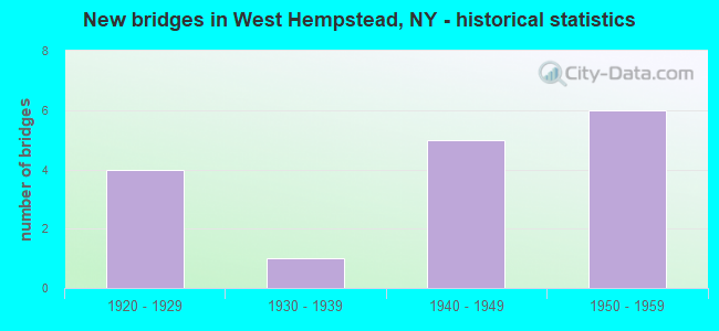
- New bridges - historical statistics
- 41920-1929
- 11930-1939
- 51940-1949
- 61950-1959
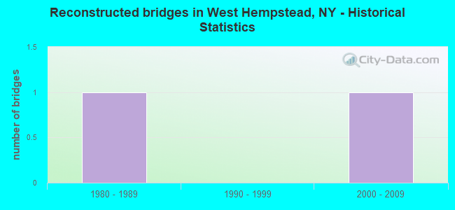
- Reconstructed bridges - Historical Statistics
- 11980-1989
- 01990-1999
- 12000-2009
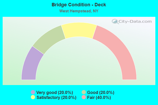
- Bridge Condition - Deck
- 20.0%Very good
- 20.0%Good
- 20.0%Satisfactory
- 40.0%Fair
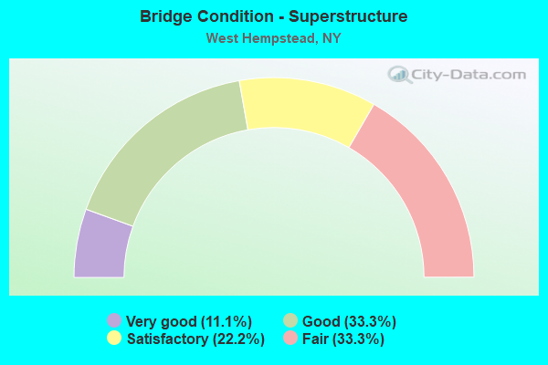
- Bridge Condition - Superstructure
- 11.1%Very good
- 33.3%Good
- 22.2%Satisfactory
- 33.3%Fair
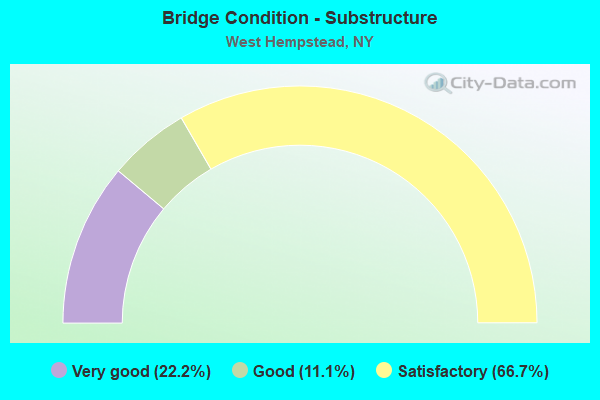
- Bridge Condition - Substructure
- 22.2%Very good
- 11.1%Good
- 66.7%Satisfactory
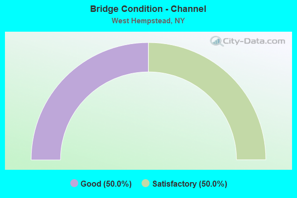
- Bridge Condition - Channel
- 50.0%Good
- 50.0%Satisfactory
Find on map >> Show street view
Structure Number: 1059411, Location: 3.8 MI E NYC L-SSP (Lat: 40.683553, Lng: -73.654825), Route carried "on" structure: State highway 908M, Year Built: 1954, Status: Open, Structure Length: 1.49m (4.89ft), Average Daily Traffic: 70,672 (year 2019), Truck Traffic: 2%, Average Future Daily Traffic: 84,064 (year 2040), Design Load: HS 20, Features Intersected: LONG ISLAND RR
Minimum Vertical Clearance: 30+ m (98+ ft), Kilometerpoint: 6.549, Lanes on structure: 3, Base Highway Network: Yes, Owner: State Highway Agency, Approaching Roadway Width: 16.2m (53.1ft), Skew: 4 degrees, Material/Design: Steel, Design/Construction: Stringer/Multi-beam, Number Of Spans In Main Unit: 1, Length of Maximum Span: 13.4m (44.0ft), Curb or Sidewalk Widths: Left: 2.8m (9.2ft), Right: 3.0m (9.8ft), Curb-To-Curb Width: 16.0m (52.5ft), Out-to-Out Width: 17.7m (58.1ft)
Condition: Deck: Satisfactory, Superstructure: Good, Substructure: Very good, Operating Rating: 53.1 metric tons, Method Used To Determine Operating Rating: Load and Resistance Factor Rating (LRFR) rating reported by rating factor(RF) method using HL-93 loadings, Inventory Rating: 40.8 metric tons, Method Used To Determine Inventory Rating: Load and Resistance Factor Rating (LRFR) rating reported by rating factor(RF) method using HL-93 loadings, Structural Evaluation: Better than present minimum criteria, Deck Geometry: Equal to present minimum criteria, Underclear: High priority of corrective action, Approach Roadway Alignment: Better than present minimum criteria, Length Of Structure Improvement: 1.49m (4.89ft), Designated Inspection Frequency: Every 24 months, Inspection Date: September 2020, Bridge Improvement Cost: $3,324,000, Roadway Improvement Cost: $1,947,000, Total Project Cost: $5,270,000 ( Estimate for 2021), Deck Structure Type: Concrete Cast-file-Place, Wearing Surface/Protective System: Wearing Surface: Bituminous, Membrane: Preformed Fabric
Find on map >> Show street view
Structure Number: 1059412, Location: 3.8 MI E NYC L-SSP (Lat: 40.683425, Lng: -73.655056), Route carried "on" structure: State highway 908M, Year Built: 1928, Status: Open, Structure Length: 1.43m (4.69ft), Average Daily Traffic: 70,672 (year 2019), Truck Traffic: 2%, Average Future Daily Traffic: 84,064 (year 2040), Features Intersected: LONG ISLAND RR
Minimum Vertical Clearance: 30+ m (98+ ft), Kilometerpoint: 6.549, Lanes on structure: 4, Base Highway Network: Yes, Owner: State Highway Agency, Approaching Roadway Width: 18.3m (60.0ft), Skew: 4 degrees, Material/Design: Steel, Design/Construction: Stringer/Multi-beam, Number Of Spans In Main Unit: 1, Length of Maximum Span: 14.0m (45.9ft), Curb-To-Curb Width: 18.3m (60.0ft), Out-to-Out Width: 20.1m (65.9ft)
Condition: Deck: Fair, Superstructure: Fair, Substructure: Satisfactory, Operating Rating: 41.7 metric tons, Method Used To Determine Operating Rating: Load Factor (LF), Inventory Rating: 25.4 metric tons, Method Used To Determine Inventory Rating: Load Factor (LF), Structural Evaluation: Somewhat better than minimum adequacy, Deck Geometry: Meets minimum limits, Underclear: Meets minimum limits, Approach Roadway Alignment: Better than present minimum criteria, Length Of Structure Improvement: 1.43m (4.69ft), Designated Inspection Frequency: Every 24 months, Inspection Date: September 2020, Bridge Improvement Cost: $3,915,000, Roadway Improvement Cost: $2,293,000, Total Project Cost: $6,208,000 ( Estimate for 2021), Deck Structure Type: Concrete Cast-file-Place, Wearing Surface/Protective System: Wearing Surface: Bituminous, Membrane: Preformed Fabric
Find on map >> Show street view
Structure Number: 105943, Location: 3.9 MI E NYC LINE ON SSP (Lat: 40.683133, Lng: -73.652853), Route carried "on" structure: County highway , Year Built: 1928, Status: Open, Structure Length: 1.89m (6.20ft), Average Daily Traffic: 7,782 (year 2020), Truck Traffic: 3%, Average Future Daily Traffic: 9,453 (year 2040), Features Intersected: RTE 908M, Facility Carried by Structure: WOODFIELD ROAD
Minimum Vertical Clearance: 30+ m (98+ ft), Kilometerpoint: 1.609, Lanes on structure: 2, Lanes under structure: 4, Owner: State Highway Agency, Approaching Roadway Width: 9.1m (29.9ft), Material/Design: Concrete, Design/Construction: Frame, Number Of Spans In Main Unit: 1, Length of Maximum Span: 17.3m (56.8ft), Curb or Sidewalk Widths: Left: 1.5m (4.9ft), Right: 1.6m (5.2ft), Curb-To-Curb Width: 9.1m (29.9ft), Out-to-Out Width: 13.6m (44.6ft)
Condition: Superstructure: Fair, Substructure: Satisfactory, Operating Rating: 40.4 metric tons, Method Used To Determine Operating Rating: Field evaluation and documented engineering judgment, Inventory Rating: 15.1 metric tons, Method Used To Determine Inventory Rating: Field evaluation and documented engineering judgment, Structural Evaluation: High priority of corrective action, Deck Geometry: High priority of corrective action, Underclear: High priority of corrective action, Approach Roadway Alignment: Equal to present desirable criteria, Length Of Structure Improvement: 1.88m (6.17ft), Designated Inspection Frequency: Every 24 months, Inspection Date: June 2021, Bridge Improvement Cost: $1,573,000, Roadway Improvement Cost: $921,000, Total Project Cost: $2,494,000 ( Estimate for 2021), Wearing Surface/Protective System: Wearing Surface: Bituminous, Membrane: Preformed Fabric
Find on map >> Show street view
Structure Number: 105944, Location: 4.4 MI E NYC LINE & SSP (Lat: 40.684733, Lng: -73.642706), Route carried "on" structure: Other road , Year Built: 1946, Year Reconstructed: 2014, Status: Open, Structure Length: 2.50m (8.20ft), Average Daily Traffic: 4,616 (year 1997), Truck Traffic: 4%, Average Future Daily Traffic: 6,462 (year 2017), Design Load: H 20, Features Intersected: 908M908M03011047_EB Road, Facility Carried by Structure: EAGLE AVENUE
Minimum Vertical Clearance: 30+ m (98+ ft), Kilometerpoint: 0.000, Lanes on structure: 2, Lanes under structure: 6, Owner: State Highway Agency, Approaching Roadway Width: 11.6m (38.1ft), Skew: 20 degrees, Material/Design: Concrete, Design/Construction: Arch - Deck, Number Of Spans In Main Unit: 1, Length of Maximum Span: 24.6m (80.7ft), Curb or Sidewalk Widths: Left: 1.4m (4.6ft), Right: 4.4m (14.4ft), Curb-To-Curb Width: 11.6m (38.1ft), Out-to-Out Width: 19.2m (63.0ft)
Condition: Superstructure: Satisfactory, Substructure: Satisfactory, Operating Rating: 64.7 metric tons, Method Used To Determine Operating Rating: Field evaluation and documented engineering judgment, Inventory Rating: 24.5 metric tons, Method Used To Determine Inventory Rating: Field evaluation and documented engineering judgment, Structural Evaluation: Equal to present minimum criteria, Deck Geometry: Somewhat better than minimum adequacy, Underclear: High priority of corrective action, Approach Roadway Alignment: Equal to present minimum criteria, Length Of Structure Improvement: 2.49m (8.17ft), Designated Inspection Frequency: Every 24 months, Inspection Date: November 2020, Bridge Improvement Cost: $3,391,000, Roadway Improvement Cost: $1,986,000, Total Project Cost: $5,377,000 ( Estimate for 2021), Wearing Surface/Protective System: Wearing Surface: Bituminous
Find on map >> Show street view
Structure Number: 1059459, Location: 4.6 MI E NY CITY LINE - S (Lat: 40.686156, Lng: -73.641100), Route carried "on" structure: State highway 908M, Year Built: 1946, Status: Open, Structure Length: 0.73m (2.40ft), Average Daily Traffic: 151,118 (year 2018), Average Future Daily Traffic: 179,754 (year 2040), Design Load: H 20, Features Intersected: HEMPSTEAD LAKE
Minimum Vertical Clearance: 30+ m (98+ ft), Kilometerpoint: 7.900, Lanes on structure: 6, Base Highway Network: Yes, Owner: State Highway Agency, Approaching Roadway Width: 25.9m (85.0ft), Skew: 20 degrees, Material/Design: Concrete, Design/Construction: Frame, Number Of Spans In Main Unit: 1, Length of Maximum Span: 6.0m (19.7ft), Curb or Sidewalk Widths: Left: 4.3m (14.1ft), Right: 4.3m (14.1ft), Curb-To-Curb Width: 25.8m (84.6ft), Out-to-Out Width: 47.2m (154.9ft)
Condition: Deck: Very good, Superstructure: Very good, Substructure: Very good, Channel: Good, Operating Rating: 74.1 metric tons, Method Used To Determine Operating Rating: Field evaluation and documented engineering judgment, Inventory Rating: 32.7 metric tons, Method Used To Determine Inventory Rating: Field evaluation and documented engineering judgment, Structural Evaluation: Equal to present desirable criteria, Deck Geometry: Meets minimum limits, Waterway Adequacy: Equal to present desirable criteria, Approach Roadway Alignment: Equal to present desirable criteria, Length Of Structure Improvement: 0.73m (2.40ft), Designated Inspection Frequency: Every 24 months, Inspection Date: October 2020, Bridge Improvement Cost: $2,752,000, Roadway Improvement Cost: $1,612,000, Total Project Cost: $4,364,000 ( Estimate for 2021)
Find on map >> Show street view
Structure Number: 1059469, Location: 5.1 MI E NYC L-SSP (Lat: 40.690025, Lng: -73.632708), Route carried "on" structure: County highway , Year Built: 1945, Status: Open, Structure Length: 2.23m (7.32ft), Average Daily Traffic: 42,685 (year 2020), Truck Traffic: 4%, Average Future Daily Traffic: 49,249 (year 2040), Design Load: H 20, Features Intersected: RTE 908M, Facility Carried by Structure: PENINSULA BLVD
Minimum Vertical Clearance: 30+ m (98+ ft), Kilometerpoint: 11.762, Lanes on structure: 6, Lanes under structure: 4, Owner: State Highway Agency, Approaching Roadway Width: 21.9m (71.9ft), Skew: 21 degrees, Material/Design: Concrete, Design/Construction: Arch - Deck, Number Of Spans In Main Unit: 1, Length of Maximum Span: 20.1m (65.9ft), Curb or Sidewalk Widths: Left: 2.5m (8.2ft), Right: 2.3m (7.5ft), Curb-To-Curb Width: 21.9m (71.9ft), Out-to-Out Width: 29.0m (95.1ft)
Condition: Superstructure: Satisfactory, Substructure: Satisfactory, Operating Rating: 58.7 metric tons, Method Used To Determine Operating Rating: Field evaluation and documented engineering judgment, Inventory Rating: 23.0 metric tons, Method Used To Determine Inventory Rating: Field evaluation and documented engineering judgment, Structural Evaluation: Somewhat better than minimum adequacy, Deck Geometry: High priority of corrective action, Underclear: High priority of corrective action, Approach Roadway Alignment: Equal to present desirable criteria, Length Of Structure Improvement: 2.22m (7.28ft), Designated Inspection Frequency: Every 24 months, Inspection Date: March 2021, Bridge Improvement Cost: $4,339,000, Roadway Improvement Cost: $2,541,000, Total Project Cost: $6,879,000 ( Estimate for 2021), Wearing Surface/Protective System: Wearing Surface: Bituminous, Membrane: Preformed Fabric
Find on map >> Show street view
Structure Number: 152021, Location: 3.9 MI E NYC LINE ON SSP (Lat: 40.683319, Lng: -73.652819), Route carried "on" structure: County highway , Year Built: 1956, Status: Open, Structure Length: 1.80m (5.91ft), Average Daily Traffic: 7,782 (year 2020), Truck Traffic: 3%, Average Future Daily Traffic: 9,453 (year 2040), Design Load: HS 20, Features Intersected: RTE 908M, Facility Carried by Structure: WOODFIELD AVENUE
Minimum Vertical Clearance: 30+ m (98+ ft), Kilometerpoint: 1.657, Lanes on structure: 2, Lanes under structure: 3, Owner: State Highway Agency, Approaching Roadway Width: 9.1m (29.9ft), Material/Design: Concrete, Design/Construction: Frame, Number Of Spans In Main Unit: 1, Length of Maximum Span: 16.4m (53.8ft), Curb or Sidewalk Widths: Left: 1.4m (4.6ft), Right: 1.4m (4.6ft), Curb-To-Curb Width: 9.1m (29.9ft), Out-to-Out Width: 13.6m (44.6ft)
Condition: Deck: Good, Superstructure: Good, Substructure: Good, Operating Rating: 84.3 metric tons, Method Used To Determine Operating Rating: Field evaluation and documented engineering judgment, Inventory Rating: 32.7 metric tons, Method Used To Determine Inventory Rating: Field evaluation and documented engineering judgment, Structural Evaluation: Better than present minimum criteria, Deck Geometry: High priority of corrective action, Underclear: High priority of corrective action, Approach Roadway Alignment: Equal to present desirable criteria, Length Of Structure Improvement: 1.79m (5.87ft), Designated Inspection Frequency: Every 24 months, Inspection Date: April 2021, Bridge Improvement Cost: $1,389,000, Roadway Improvement Cost: $813,000, Total Project Cost: $2,202,000 ( Estimate for 2021), Wearing Surface/Protective System: Wearing Surface: Bituminous, Membrane: Preformed Fabric
Find on map >> Show street view
Structure Number: 1520229, Location: 5.1 MI E NYC L-SSP (Lat: 40.690258, Lng: -73.632769), Route carried "on" structure: County highway , Year Built: 1955, Status: Open, Structure Length: 2.23m (7.32ft), Average Daily Traffic: 42,685 (year 2020), Truck Traffic: 4%, Average Future Daily Traffic: 49,249 (year 2040), Design Load: HS 20, Features Intersected: RTE 908M, Facility Carried by Structure: PENINSULA BLVD
Minimum Vertical Clearance: 30+ m (98+ ft), Kilometerpoint: 11.762, Lanes on structure: 6, Lanes under structure: 4, Owner: State Highway Agency, Approaching Roadway Width: 21.9m (71.9ft), Skew: 20 degrees, Material/Design: Concrete, Design/Construction: Arch - Deck, Number Of Spans In Main Unit: 1, Length of Maximum Span: 20.1m (65.9ft), Curb or Sidewalk Widths: Left: 2.8m (9.2ft), Right: 2.7m (8.9ft), Curb-To-Curb Width: 21.9m (71.9ft), Out-to-Out Width: 29.0m (95.1ft)
Condition: Superstructure: Good, Substructure: Satisfactory, Operating Rating: 86.9 metric tons, Method Used To Determine Operating Rating: Field evaluation and documented engineering judgment, Inventory Rating: 32.7 metric tons, Method Used To Determine Inventory Rating: Field evaluation and documented engineering judgment, Structural Evaluation: Equal to present minimum criteria, Deck Geometry: High priority of corrective action, Underclear: High priority of corrective action, Approach Roadway Alignment: Better than present minimum criteria, Length Of Structure Improvement: 2.22m (7.28ft), Designated Inspection Frequency: Every 24 months, Inspection Date: March 2021, Bridge Improvement Cost: $4,578,000, Roadway Improvement Cost: $2,681,000, Total Project Cost: $7,259,000 ( Estimate for 2021), Wearing Surface/Protective System: Wearing Surface: Bituminous, Membrane: Preformed Fabric
Find on map >> Show street view
Structure Number: 330004, Location: 2.1 MI SW OF HEMPSTEAD (Lat: 40.687056, Lng: -73.660544), Route carried "on" structure: Other road , Year Built: 1932, Year Reconstructed: 1985, Status: Open, Structure Length: 0.76m (2.49ft), Average Daily Traffic: 12,550 (year 2020), Truck Traffic: 4%, Average Future Daily Traffic: 15,245 (year 2040), Features Intersected: PINES BROOK, Facility Carried by Structure: HEMPSTEAD AVENUE
Minimum Vertical Clearance: 30+ m (98+ ft), Kilometerpoint: 3.652, Lanes on structure: 4, Owner: County Highway Agency, Approaching Roadway Width: 15.2m (49.9ft), Skew: 1 degrees, Material/Design: Concrete, Design/Construction: Slab, Number Of Spans In Main Unit: 2, Length of Maximum Span: 3.6m (11.8ft), Curb or Sidewalk Widths: Left: 2.4m (7.9ft), Right: 2.1m (6.9ft), Curb-To-Curb Width: 17.9m (58.7ft), Out-to-Out Width: 37.9m (124.3ft)
Condition: Deck: Fair, Superstructure: Fair, Substructure: Satisfactory, Channel: Satisfactory, Operating Rating: 59.0 metric tons, Method Used To Determine Operating Rating: Load Factor (LF), Inventory Rating: 35.4 metric tons, Method Used To Determine Inventory Rating: Load Factor (LF), Structural Evaluation: Somewhat better than minimum adequacy, Deck Geometry: Somewhat better than minimum adequacy, Waterway Adequacy: Somewhat better than minimum adequacy, Approach Roadway Alignment: Equal to present desirable criteria, Length Of Structure Improvement: 0.76m (2.49ft), Designated Inspection Frequency: Every 24 months, Inspection Date: Febuary 2020, Bridge Improvement Cost: $1,097,000, Roadway Improvement Cost: $642,000, Total Project Cost: $1,739,000 ( Estimate for 2021), Wearing Surface/Protective System: Wearing Surface: Monolithic Concrete
Find on map >> Show street view
Structure Number: 10594, Location: 3.3 MI E NYC LINE ON SSP (Lat: 40.682253, Lng: -73.663406), Route carried "under" structure: State highway 908M, Year Built: 1929, Structure Length: 0. m, Average Daily Traffic: 198,681 (year 2002), Features Intersected: RTE 908M, Facility Carried by Structure: HEMPSTEAD AVENUE
Minimum Vertical Clearance: 4.11m (13.48ft), Kilometerpoint: 5.792, Lanes on structure: 4, Lanes under structure: 4, Material/Design: Concrete, Design/Construction: Arch - Deck, Length of Maximum Span: 20.1m (65.9ft)
Find on map >> Show street view
Structure Number: 105943, Location: 3.9 MI E NYC LINE ON SSP (Lat: 40.683133, Lng: -73.652853), Route carried "under" structure: State highway 908M, Year Built: 1928, Structure Length: 0. m, Average Daily Traffic: 198,681 (year 2002), Features Intersected: RTE 908M, Facility Carried by Structure: WOODFIELD ROAD
Minimum Vertical Clearance: 4.04m (13.25ft), Kilometerpoint: 6.710, Lanes on structure: 2, Lanes under structure: 4, Material/Design: Concrete, Design/Construction: Frame, Length of Maximum Span: 17.3m (56.8ft)
Find on map >> Show street view
Structure Number: 105944, Location: 4.4 MI E NYC LINE & SSP (Lat: 40.684733, Lng: -73.642706), Route carried "under" structure: State highway 908M, Year Built: 1946, Structure Length: 0. m, Average Daily Traffic: 174,521 (year 2002), Features Intersected: 908M908M03011047_EB Road, Facility Carried by Structure: EAGLE AVENUE
Minimum Vertical Clearance: 3.99m (13.09ft), Kilometerpoint: 7.675, Lanes on structure: 2, Lanes under structure: 3, Material/Design: Concrete, Design/Construction: Arch - Deck, Length of Maximum Span: 24.6m (80.7ft)
Find on map >> Show street view
Structure Number: 1059469, Location: 5.1 MI E NYC L-SSP (Lat: 40.690025, Lng: -73.632708), Route carried "under" structure: State highway 908M, Year Built: 1945, Structure Length: 0. m, Average Daily Traffic: 170,636 (year 2002), Features Intersected: RTE 908M, Facility Carried by Structure: PENINSULA BLVD
Minimum Vertical Clearance: 4.27m (14.01ft), Kilometerpoint: 8.721, Lanes on structure: 6, Lanes under structure: 4, Material/Design: Concrete, Design/Construction: Arch - Deck, Length of Maximum Span: 20.1m (65.9ft)
Find on map >> Show street view
Structure Number: 15202, Location: 3.3 MI E NYC LINE ON SSP (Lat: 40.682525, Lng: -73.663331), Route carried "under" structure: State highway 908M, Year Built: 1956, Structure Length: 0. m, Average Daily Traffic: 198,681 (year 2002), Features Intersected: RTE 908M, Facility Carried by Structure: HEMPSTEAD AVENUE
Minimum Vertical Clearance: 4.14m (13.58ft), Kilometerpoint: 5.792, Lanes on structure: 4, Lanes under structure: 4, Material/Design: Concrete, Design/Construction: Arch - Deck, Length of Maximum Span: 21.6m (70.9ft)
Find on map >> Show street view
Structure Number: 152021, Location: 3.9 MI E NYC LINE ON SSP (Lat: 40.683319, Lng: -73.652819), Route carried "under" structure: State highway 908M, Year Built: 1956, Structure Length: 0. m, Average Daily Traffic: 198,681 (year 2002), Features Intersected: RTE 908M, Facility Carried by Structure: WOODFIELD AVENUE
Minimum Vertical Clearance: 3.86m (12.66ft), Kilometerpoint: 6.710, Lanes on structure: 2, Lanes under structure: 3, Material/Design: Concrete, Design/Construction: Frame, Length of Maximum Span: 16.4m (53.8ft)
Find on map >> Show street view
Structure Number: 1520229, Location: 5.1 MI E NYC L-SSP (Lat: 40.690258, Lng: -73.632769), Route carried "under" structure: State highway 908M, Year Built: 1955, Structure Length: 0. m, Average Daily Traffic: 170,636 (year 2002), Features Intersected: RTE 908M, Facility Carried by Structure: PENINSULA BLVD
Minimum Vertical Clearance: 4.09m (13.42ft), Kilometerpoint: 8.721, Lanes on structure: 6, Lanes under structure: 4, Material/Design: Concrete, Design/Construction: Arch - Deck, Length of Maximum Span: 20.1m (65.9ft)