Bridge Statistics for Westford, Massachusetts (MA)
Condition, Traffic, Stress, Structural Evaluation, Project Costs
- National Bridge Inventory (NBI) Statistics
- 20Number of bridges
- 128ft / 38.9mTotal length
- $33,361,000Total costs
- 523,933Total average daily traffic
- 26,765Total average daily truck traffic
- 815,914Total future (year 2031) average daily traffic
- National Bridge Inventory (NBI) Registered Bridges for Westford
- No street view available for this location
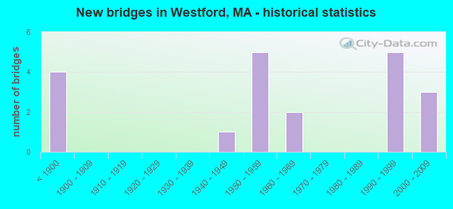
- New bridges - historical statistics
- 4Before 1900
- 11940-1949
- 51950-1959
- 21960-1969
- 51990-1999
- 32000-2009
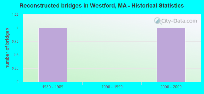
- Reconstructed bridges - Historical Statistics
- 11980-1989
- 01990-1999
- 12000-2009
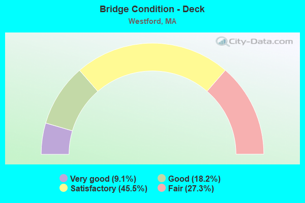
- Bridge Condition - Deck
- 9.1%Very good
- 18.2%Good
- 45.5%Satisfactory
- 27.3%Fair
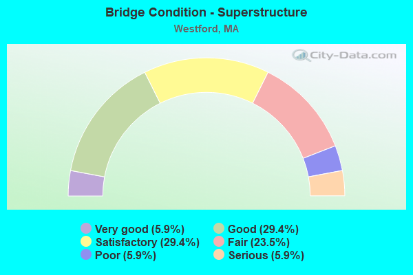
- Bridge Condition - Superstructure
- 5.9%Very good
- 29.4%Good
- 29.4%Satisfactory
- 23.5%Fair
- 5.9%Poor
- 5.9%Serious
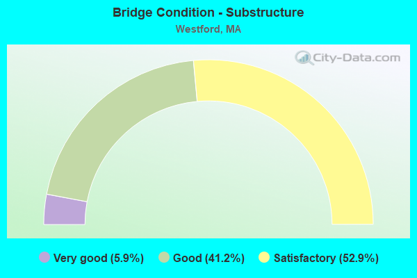
- Bridge Condition - Substructure
- 5.9%Very good
- 41.2%Good
- 52.9%Satisfactory
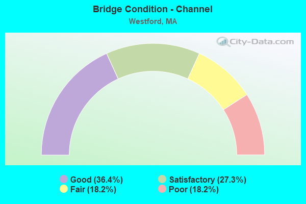
- Bridge Condition - Channel
- 36.4%Good
- 27.3%Satisfactory
- 18.2%Fair
- 18.2%Poor
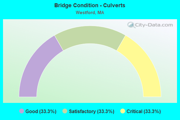
- Bridge Condition - Culverts
- 33.3%Good
- 33.3%Satisfactory
- 33.3%Critical
Find on map >> Show street view
Structure Number: W26001250MUNNBI, Location: 1 MI W OF CHELMS LINE (Lat: 42.609664, Lng: -71.410783), Route carried "on" structure: City street , Year Built: 1860, Year Reconstructed: 2005, Status: Open, Structure Length: 1.10m (3.61ft), Average Daily Traffic: 3,300 (year 2013), Truck Traffic: 1%, Average Future Daily Traffic: 5,212 (year 2032), Design Load: HS 20, Features Intersected: WATER STONY BROOK, Facility Carried by Structure: HWY BROOKSIDE RD
Minimum Vertical Clearance: 30+ m (98+ ft), Kilometerpoint: 0.241, Lanes on structure: 2, Owner: Town or Township Highway Agency, Approaching Roadway Width: 9.2m (30.2ft), Skew: 9 degrees, Material/Design: Concrete continuous, Design/Construction: Slab, Number Of Spans In Main Unit: 3, Length of Maximum Span: 2.7m (8.9ft), Curb or Sidewalk Widths: Left: 1.6m (5.2ft), Right: 0.0m, Curb-To-Curb Width: 9.2m (30.2ft), Out-to-Out Width: 13.8m (45.3ft)
Condition: Deck: Very good, Superstructure: Very good, Substructure: Satisfactory, Channel: Satisfactory, Operating Rating: 85.7 metric tons, Method Used To Determine Operating Rating: Load Factor (LF), Inventory Rating: 51.3 metric tons, Method Used To Determine Inventory Rating: Load Factor (LF), Structural Evaluation: Equal to present minimum criteria, Deck Geometry: Meets minimum limits, Waterway Adequacy: Superior to present desirable criteria, Approach Roadway Alignment: Equal to present minimum criteria, Length Of Structure Improvement: 1.20m (3.94ft), Designated Inspection Frequency: Every 24 months, Underwater Inspection Frequency: Every 36 months, Inspection Date: September 2021, Underwater Inspection Date: May 2020, Bridge Improvement Cost: $476,000, Roadway Improvement Cost: $48,000, Total Project Cost: $715,000 ( Estimate for 2022), Deck Structure Type: Concrete Cast-file-Place, Wearing Surface/Protective System: Wearing Surface: Bituminous, Membrane: Preformed Fabric, Deck Protection: Epoxy Coated Reinforcing
Find on map >> Show street view
Structure Number: W2600226DMUNNBI, Location: .3 MI.N. OF LOWELL RD. (Lat: 42.602697, Lng: -71.419908), Route carried "on" structure: City street , Year Built: 1880, Status: Open, Structure Length: 1.22m (4.00ft), Average Daily Traffic: 600 (year 2016), Truck Traffic: 1%, Average Future Daily Traffic: 948 (year 2033), Features Intersected: WATER STONY BROOK, Facility Carried by Structure: HWY STONY BRK RD
Minimum Vertical Clearance: 30+ m (98+ ft), Kilometerpoint: 1.255, Lanes on structure: 1, Owner: Town or Township Highway Agency, Approaching Roadway Width: 4.5m (14.8ft), Material/Design: Masonry, Design/Construction: Arch - Deck, Number Of Spans In Main Unit: 2, Length of Maximum Span: 4.6m (15.1ft), Curb-To-Curb Width: 4.5m (14.8ft), Out-to-Out Width: 5.5m (18.0ft)
Condition: Superstructure: Fair, Substructure: Satisfactory, Channel: Satisfactory, Operating Rating: 44.1 metric tons, Method Used To Determine Operating Rating: No rating analysis performed, Inventory Rating: 27.5 metric tons, Method Used To Determine Inventory Rating: Allowable Stress (AS), Structural Evaluation: Somewhat better than minimum adequacy, Deck Geometry: High priority of replacement, Waterway Adequacy: Better than present minimum criteria, Approach Roadway Alignment: Equal to present minimum criteria, Length Of Structure Improvement: 1.90m (6.23ft), Designated Inspection Frequency: Every 24 months, Inspection Date: Febuary 2022, Bridge Improvement Cost: $1,314,000, Roadway Improvement Cost: $132,000, Total Project Cost: $1,972,000 ( Estimate for 2022), Wearing Surface/Protective System: Wearing Surface: Bituminous
Find on map >> Show street view
Structure Number: W26003AA3MUNNBI, Location: AT JCT. OF LOWELL ST. (Lat: 42.597031, Lng: -71.435064), Route carried "on" structure: City street , Year Built: 1993, Status: Open, Structure Length: 1.27m (4.17ft), Average Daily Traffic: 8,034 (year 2019), Truck Traffic: 5%, Average Future Daily Traffic: 26,216 (year 2031), Design Load: HS 20, Features Intersected: WATER STONY BROOK, Facility Carried by Structure: HWY DEPOT RD
Minimum Vertical Clearance: 30+ m (98+ ft), Kilometerpoint: 0.064, Lanes on structure: 2, Owner: Town or Township Highway Agency, Approaching Roadway Width: 6.8m (22.3ft), Skew: 1 degrees, Material/Design: Prestressed concrete, Design/Construction: Slab, Number Of Spans In Main Unit: 1, Length of Maximum Span: 12.1m (39.7ft), Curb or Sidewalk Widths: Left: 0.1m (0.3ft), Right: 0.1m (0.3ft), Curb-To-Curb Width: 6.8m (22.3ft), Out-to-Out Width: 8.2m (26.9ft)
Condition: Deck: Satisfactory, Superstructure: Satisfactory, Substructure: Satisfactory, Channel: Good, Operating Rating: 54.5 metric tons, Method Used To Determine Operating Rating: Load Factor (LF), Inventory Rating: 32.7 metric tons, Method Used To Determine Inventory Rating: Load Factor (LF), Structural Evaluation: Equal to present minimum criteria, Deck Geometry: High priority of replacement, Waterway Adequacy: Superior to present desirable criteria, Approach Roadway Alignment: Meets minimum limits, Length Of Structure Improvement: 1.30m (4.27ft), Designated Inspection Frequency: Every 24 months, Underwater Inspection Frequency: Every 36 months, Inspection Date: May 2020, Underwater Inspection Date: Febuary 2019, Bridge Improvement Cost: $806,000, Roadway Improvement Cost: $81,000, Total Project Cost: $1,210,000 ( Estimate for 2022), Deck Structure Type: Concrete Precast Panels, Wearing Surface/Protective System: Wearing Surface: Bituminous, Membrane: Built-up, Deck Protection: Epoxy Coated Reinforcing
Find on map >> Show street view
Structure Number: W26004252MUNNBI, Location: .1 MI SE OF NORTH ST (Lat: 42.596144, Lng: -71.463047), Route carried "on" structure: City street , Year Built: 1997, Status: Open, Structure Length: 0.97m (3.18ft), Average Daily Traffic: 1,000 (year 2014), Truck Traffic: 6%, Average Future Daily Traffic: 1,579 (year 2033), Design Load: HS 20, Features Intersected: WATER STONY BROOK, Facility Carried by Structure: HWY RIVER ST
Minimum Vertical Clearance: 30+ m (98+ ft), Kilometerpoint: 0.676, Lanes on structure: 2, Owner: Town or Township Highway Agency, Approaching Roadway Width: 7.9m (25.9ft), Material/Design: Concrete, Design/Construction: Arch - Deck, Number Of Spans In Main Unit: 1, Length of Maximum Span: 9.7m (31.8ft), Curb-To-Curb Width: 7.9m (25.9ft), Out-to-Out Width: 9.1m (29.9ft)
Condition: Superstructure: Good, Substructure: Very good, Channel: Good, Operating Rating: 55.9 metric tons, Method Used To Determine Operating Rating: Load Factor (LF), Inventory Rating: 33.5 metric tons, Method Used To Determine Inventory Rating: Load Factor (LF), Structural Evaluation: Better than present minimum criteria, Deck Geometry: Somewhat better than minimum adequacy, Waterway Adequacy: Equal to present minimum criteria, Approach Roadway Alignment: Somewhat better than minimum adequacy, Length Of Structure Improvement: 1.00m (3.28ft), Designated Inspection Frequency: Every 24 months, Inspection Date: Febuary 2022, Bridge Improvement Cost: $404,000, Roadway Improvement Cost: $41,000, Total Project Cost: $607,000 ( Estimate for 2022)
Find on map >> Show street view
Structure Number: W2600526EMUNNBI, Location: GRANITEVILLE - SECTION (Lat: 42.595892, Lng: -71.466147), Route carried "on" structure: City street , Year Built: 1870, Year Reconstructed: 1988, Status: Open, Structure Length: 0.70m (2.30ft), Average Daily Traffic: 2,730 (year 2014), Truck Traffic: 6%, Average Future Daily Traffic: 4,311 (year 2031), Design Load: H 20, Features Intersected: WATER STONY BROOK, Facility Carried by Structure: HWY BROADWAY ST
Minimum Vertical Clearance: 30+ m (98+ ft), Kilometerpoint: 0.708, Lanes on structure: 2, Owner: Town or Township Highway Agency, Approaching Roadway Width: 6.1m (20.0ft), Material/Design: Prestressed concrete, Design/Construction: Slab, Number Of Spans In Main Unit: 1, Length of Maximum Span: 6.7m (22.0ft), Curb or Sidewalk Widths: Left: 0.5m (1.6ft), Right: 0.2m (0.7ft), Curb-To-Curb Width: 5.7m (18.7ft), Out-to-Out Width: 7.2m (23.6ft)
Condition: Deck: Satisfactory, Superstructure: Satisfactory, Substructure: Satisfactory, Channel: Poor, Operating Rating: 75.2 metric tons, Method Used To Determine Operating Rating: Load Factor (LF), Inventory Rating: 45.0 metric tons, Method Used To Determine Inventory Rating: Load Factor (LF), Structural Evaluation: Equal to present minimum criteria, Waterway Adequacy: Equal to present desirable criteria, Approach Roadway Alignment: Equal to present minimum criteria, Length Of Structure Improvement: 1.40m (4.59ft), Designated Inspection Frequency: Every 24 months, Inspection Date: September 2020, Bridge Improvement Cost: $1,093,000, Roadway Improvement Cost: $110,000, Total Project Cost: $1,640,000 ( Estimate for 2022), Deck Structure Type: Concrete Precast Panels, Wearing Surface/Protective System: Wearing Surface: Bituminous, Membrane: Built-up, Deck Protection: Epoxy Coated Reinforcing
Find on map >> Show street view
Structure Number: W2600626HMUNNBI, Location: 1 MI S OF ST-40 (Lat: 42.592786, Lng: -71.468661), Route carried "on" structure: City street , Year Built: 1870, Status: Posted for load, Structure Length: 0.85m (2.79ft), Average Daily Traffic: 800 (year 2022), Truck Traffic: 1%, Average Future Daily Traffic: 4,264 (year 2033), Features Intersected: WATER STONY BROOK, Facility Carried by Structure: HWY BRIDGE ST
Minimum Vertical Clearance: 30+ m (98+ ft), Kilometerpoint: 0.016, Lanes on structure: 2, Owner: Town or Township Highway Agency, Approaching Roadway Width: 6.1m (20.0ft), Material/Design: Masonry, Design/Construction: Slab, Number Of Spans In Main Unit: 4, Length of Maximum Span: 1.8m (5.9ft), Curb-To-Curb Width: 6.1m (20.0ft), Out-to-Out Width: 7.0m (23.0ft)
Condition: Deck: Satisfactory, Superstructure: Satisfactory, Substructure: Satisfactory, Channel: Satisfactory, Operating Rating: 90.5 metric tons, Method Used To Determine Operating Rating: Allowable Stress (AS), Inventory Rating: 48.1 metric tons, Method Used To Determine Inventory Rating: Allowable Stress (AS), Structural Evaluation: Equal to present minimum criteria, Deck Geometry: High priority of corrective action, Waterway Adequacy: Somewhat better than minimum adequacy, Approach Roadway Alignment: High priority of corrective action, Length Of Structure Improvement: 1.60m (5.25ft), Designated Inspection Frequency: Every 24 months, Underwater Inspection Frequency: Every 27 months, Inspection Date: Febuary 2022, Underwater Inspection Date: June 2020, Bridge Improvement Cost: $1,098,000, Roadway Improvement Cost: $110,000, Total Project Cost: $1,648,000 ( Estimate for 2022), Deck Structure Type: Other, Wearing Surface/Protective System: Wearing Surface: Bituminous
Find on map >> Show street view
Structure Number: W2600726FMUNNBI, Location: .4 MI. N. OF RT. 225 (Lat: 42.584472, Lng: -71.478806), Route carried "on" structure: City street , Year Built: 1949, Status: Open, Structure Length: 0.79m (2.59ft), Average Daily Traffic: 2,825 (year 2015), Truck Traffic: 5%, Average Future Daily Traffic: 3,948 (year 2033), Features Intersected: WATER STONY BROOK, Facility Carried by Structure: HWY TOWN FARM RD
Minimum Vertical Clearance: 30+ m (98+ ft), Kilometerpoint: 0.338, Lanes on structure: 2, Owner: Town or Township Highway Agency, Approaching Roadway Width: 7.0m (23.0ft), Material/Design: Steel, Design/Construction: Culvert, Number Of Spans In Main Unit: 2, Length of Maximum Span: 3.0m (9.8ft), Curb-To-Curb Width: 8.3m (27.2ft), Out-to-Out Width: 9.4m (30.8ft)
Condition: Channel: Good, Culverts: Satisfactory, Operating Rating: 84.0 metric tons, Method Used To Determine Operating Rating: Load Factor (LF), Inventory Rating: 50.0 metric tons, Method Used To Determine Inventory Rating: Load Factor (LF), Structural Evaluation: Equal to present minimum criteria, Deck Geometry: High priority of corrective action, Waterway Adequacy: Equal to present desirable criteria, Approach Roadway Alignment: Equal to present desirable criteria, Length Of Structure Improvement: 0.60m (1.97ft), Designated Inspection Frequency: Every 24 months, Inspection Date: March 2020, Bridge Improvement Cost: $447,000, Roadway Improvement Cost: $45,000, Total Project Cost: $671,000 ( Estimate for 2022)
Find on map >> Show street view
Structure Number: W260089BLMUNNBI, Location: AT INT. OF PRESCOTT ST. (Lat: 42.580319, Lng: -71.486908), Route carried "on" structure: US 225, Year Built: 2005, Status: Open, Structure Length: 0.73m (2.40ft), Average Daily Traffic: 6,026 (year 2018), Truck Traffic: 2%, Average Future Daily Traffic: 3,632 (year 2032), Design Load: HS 20, Features Intersected: WATER STONY BROOK
Minimum Vertical Clearance: 30+ m (98+ ft), Kilometerpoint: 18.032, Lanes on structure: 2, Owner: Town or Township Highway Agency, Approaching Roadway Width: 9.0m (29.5ft), Skew: 2 degrees, Material/Design: Concrete, Design/Construction: Culvert, Number Of Spans In Main Unit: 2, Length of Maximum Span: 3.4m (11.2ft), Curb or Sidewalk Widths: Left: 1.7m (5.6ft), Right: 0.0m, Curb-To-Curb Width: 9.0m (29.5ft), Out-to-Out Width: 11.5m (37.7ft)
Condition: Channel: Fair, Culverts: Good, Structural Evaluation: Better than present minimum criteria, Deck Geometry: High priority of replacement, Waterway Adequacy: Equal to present desirable criteria, Approach Roadway Alignment: Equal to present desirable criteria, Length Of Structure Improvement: 0.50m (1.64ft), Designated Inspection Frequency: Every 24 months, Inspection Date: July 2021, Bridge Improvement Cost: $312,000, Roadway Improvement Cost: $32,000, Total Project Cost: $469,000 ( Estimate for 2022)
Find on map >> Show street view
Structure Number: W260102A0DOT634, Location: 50 FT S OF BROADWAY (Lat: 42.592172, Lng: -71.459817), Route carried "on" structure: City street , Year Built: 1998, Status: Open, Structure Length: 2.47m (8.10ft), Average Daily Traffic: 4,300 (year 2002), Truck Traffic: 1%, Average Future Daily Traffic: 4,738 (year 2031), Design Load: HS 20, Features Intersected: RR BMRR, Facility Carried by Structure: HWY GRANITEVILLE
Minimum Vertical Clearance: 30+ m (98+ ft), Kilometerpoint: 0.000, Lanes on structure: 2, Owner: State Highway Agency, Approaching Roadway Width: 7.3m (24.0ft), Material/Design: Prestressed concrete, Design/Construction: Box Beam or Girders - Multiple, Number Of Spans In Main Unit: 1, Length of Maximum Span: 23.5m (77.1ft), Curb or Sidewalk Widths: Left: 1.5m (4.9ft), Right: 0.0m, Curb-To-Curb Width: 7.3m (24.0ft), Out-to-Out Width: 9.6m (31.5ft)
Condition: Deck: Fair, Superstructure: Fair, Substructure: Good, Operating Rating: 61.2 metric tons, Method Used To Determine Operating Rating: Allowable Stress (AS), Inventory Rating: 55.1 metric tons, Method Used To Determine Inventory Rating: Allowable Stress (AS), Structural Evaluation: Somewhat better than minimum adequacy, Deck Geometry: High priority of replacement, Underclear: Meets minimum limits, Approach Roadway Alignment: Equal to present minimum criteria, Length Of Structure Improvement: 2.50m (8.20ft), Designated Inspection Frequency: Every 24 months, Inspection Date: October 2020, Bridge Improvement Cost: $943,000, Roadway Improvement Cost: $95,000, Total Project Cost: $1,415,000 ( Estimate for 2022), Deck Structure Type: Concrete Cast-file-Place, Wearing Surface/Protective System: Wearing Surface: Monolithic Concrete, Deck Protection: Epoxy Coated Reinforcing
Find on map >> Show street view
Structure Number: W2601426GMUNNBI, Location: .2 MI. E. OF LITTLETON LN (Lat: 42.572483, Lng: -71.478739), Route carried "on" structure: City street , Year Built: 1957, Status: Open, Structure Length: 0.76m (2.49ft), Average Daily Traffic: 2,618 (year 2020), Truck Traffic: 7%, Average Future Daily Traffic: 5,212 (year 2032), Features Intersected: WATER BEAVER BROOK, Facility Carried by Structure: HWY BEAVER BK RD
Minimum Vertical Clearance: 30+ m (98+ ft), Kilometerpoint: 1.159, Lanes on structure: 2, Owner: Town or Township Highway Agency, Approaching Roadway Width: 7.9m (25.9ft), Material/Design: Steel, Design/Construction: Culvert, Number Of Spans In Main Unit: 2, Length of Maximum Span: 3.4m (11.2ft), Curb-To-Curb Width: 7.4m (24.3ft), Out-to-Out Width: 10.3m (33.8ft)
Condition: Channel: Fair, Culverts: Critical, Inventory Rating: 96.4 metric tons, Method Used To Determine Inventory Rating: Load Factor (LF), Structural Evaluation: High priority of replacement, Deck Geometry: High priority of replacement, Waterway Adequacy: Equal to present minimum criteria, Approach Roadway Alignment: Equal to present desirable criteria, Length Of Structure Improvement: 1.70m (5.58ft), Designated Inspection Frequency: Every 3 months, Underwater Inspection Frequency: Every 6 months, Other Special Inspection Frequency: Every 3 months, Inspection Date: August 2021, Underwater Inspection Date: September 2021, Other Special Inspection Date: Febuary 2022, Bridge Improvement Cost: $813,000, Roadway Improvement Cost: $82,000, Total Project Cost: $1,220,000 ( Estimate for 2022)
Find on map >> Show street view
Structure Number: W2601683PDOTNBI, Location: 1.1 MI N OF RTE 40 (Lat: 42.643806, Lng: -71.416131), Route carried "on" structure: US 3, Year Built: 2004, Status: Open, Structure Length: 1.28m (4.20ft), Average Daily Traffic: 48,336 (year 2019), Truck Traffic: 3%, Average Future Daily Traffic: 135,820 (year 2031), Design Load: HS 20, Features Intersected: HWY LEDGE RD
Minimum Vertical Clearance: 30+ m (98+ ft), Kilometerpoint: 140.170, Lanes on structure: 3, Lanes under structure: 2, Base Highway Network: Yes, Owner: State Highway Agency, Approaching Roadway Width: 22.0m (72.2ft), Material/Design: Concrete, Design/Construction: Arch - Deck, Number Of Spans In Main Unit: 1, Length of Maximum Span: 12.8m (42.0ft), Curb-To-Curb Width: 22.0m (72.2ft), Out-to-Out Width: 25.2m (82.7ft)
Condition: Superstructure: Good, Substructure: Satisfactory, Inventory Rating: 77.9 metric tons, Method Used To Determine Inventory Rating: Load Factor (LF), Structural Evaluation: Equal to present minimum criteria, Deck Geometry: Superior to present desirable criteria, Underclear: Meets minimum limits, Approach Roadway Alignment: Superior to present desirable criteria, Length Of Structure Improvement: 1.30m (4.27ft), Designated Inspection Frequency: Every 24 months, Inspection Date: November 2020, Bridge Improvement Cost: $258,000, Roadway Improvement Cost: $26,000, Total Project Cost: $388,000 ( Estimate for 2022)
Find on map >> Show street view
Structure Number: W2601683QDOTNBI, Location: 1.1 M. NO. OF RT 40 (Lat: 42.643933, Lng: -71.415744), Route carried "on" structure: US 3, Year Built: 2004, Status: Open, Structure Length: 1.28m (4.20ft), Average Daily Traffic: 49,483 (year 2015), Truck Traffic: 15%, Average Future Daily Traffic: 135,820 (year 2031), Design Load: HS 20, Features Intersected: HWY LEDGE RD
Minimum Vertical Clearance: 99.00m (324.80ft), Kilometerpoint: 0.000, Lanes on structure: 3, Lanes under structure: 2, Base Highway Network: Yes, Owner: State Highway Agency, Approaching Roadway Width: 25.5m (83.7ft), Material/Design: Concrete, Design/Construction: Arch - Deck, Number Of Spans In Main Unit: 1, Length of Maximum Span: 12.8m (42.0ft), Curb-To-Curb Width: 25.5m (83.7ft), Out-to-Out Width: 28.9m (94.8ft)
Condition: Superstructure: Good, Substructure: Satisfactory, Inventory Rating: 77.9 metric tons, Method Used To Determine Inventory Rating: Load Factor (LF), Structural Evaluation: Equal to present minimum criteria, Deck Geometry: Superior to present desirable criteria, Approach Roadway Alignment: Equal to present desirable criteria, Length Of Structure Improvement: 1.30m (4.27ft), Designated Inspection Frequency: Every 24 months, Inspection Date: November 2020, Bridge Improvement Cost: $296,000, Roadway Improvement Cost: $30,000, Total Project Cost: $445,000 ( Estimate for 2022), Wearing Surface/Protective System: Wearing Surface: Bituminous
Find on map >> Show street view
Structure Number: W2601827RDOTNBI, Location: 1 MI S OF BOSTON RD (Lat: 42.556044, Lng: -71.449908), Route carried "on" structure: Interstate 495, Year Built: 1959, Status: Open, Structure Length: 3.90m (12.80ft), Average Daily Traffic: 62,079 (year 2019), Truck Traffic: 5%, Average Future Daily Traffic: 69,489 (year 2031), Design Load: H 20, Features Intersected: ST225 CONCORD RD
Minimum Vertical Clearance: 30+ m (98+ ft), Kilometerpoint: 131.963, Lanes on structure: 3, Lanes under structure: 2, Base Highway Network: Yes, Owner: State Highway Agency, Approaching Roadway Width: 15.2m (49.9ft), Skew: 2 degrees, Material/Design: Steel, Design/Construction: Stringer/Multi-beam, Number Of Spans In Main Unit: 3, Length of Maximum Span: 17.1m (56.1ft), Curb or Sidewalk Widths: Left: 0.5m (1.6ft), Right: 0.5m (1.6ft), Curb-To-Curb Width: 15.2m (49.9ft), Out-to-Out Width: 17.7m (58.1ft)
Condition: Deck: Good, Superstructure: Satisfactory, Substructure: Good, Operating Rating: 61.9 metric tons, Method Used To Determine Operating Rating: Load Factor (LF), Inventory Rating: 37.1 metric tons, Method Used To Determine Inventory Rating: Load Factor (LF), Structural Evaluation: Equal to present minimum criteria, Deck Geometry: Meets minimum limits, Underclear: Meets minimum limits, Approach Roadway Alignment: Equal to present desirable criteria, Length Of Structure Improvement: 4.00m (13.12ft), Designated Inspection Frequency: Every 24 months, Inspection Date: November 2020, Bridge Improvement Cost: $1,207,000, Roadway Improvement Cost: $121,000, Total Project Cost: $1,811,000 ( Estimate for 2022), Deck Structure Type: Concrete Cast-file-Place, Wearing Surface/Protective System: Wearing Surface: Bituminous
Find on map >> Show street view
Structure Number: W2601827TDOTNBI, Location: MM 81.7 OF 495 NB (Lat: 42.555714, Lng: -71.449553), Route carried "on" structure: Interstate 495, Year Built: 1959, Status: Open, Structure Length: 4.21m (13.81ft), Average Daily Traffic: 59,392 (year 2019), Truck Traffic: 5%, Average Future Daily Traffic: 69,489 (year 2031), Design Load: H 20, Features Intersected: ST225 CONCORD RD
Minimum Vertical Clearance: 30+ m (98+ ft), Kilometerpoint: 131.963, Lanes on structure: 3, Lanes under structure: 2, Base Highway Network: Yes, Owner: State Highway Agency, Approaching Roadway Width: 15.2m (49.9ft), Skew: 2 degrees, Material/Design: Steel, Design/Construction: Stringer/Multi-beam, Number Of Spans In Main Unit: 3, Length of Maximum Span: 17.1m (56.1ft), Curb or Sidewalk Widths: Left: 0.5m (1.6ft), Right: 0.5m (1.6ft), Curb-To-Curb Width: 15.2m (49.9ft), Out-to-Out Width: 17.7m (58.1ft)
Condition: Deck: Good, Superstructure: Satisfactory, Substructure: Satisfactory, Operating Rating: 61.9 metric tons, Method Used To Determine Operating Rating: Load Factor (LF), Inventory Rating: 37.1 metric tons, Method Used To Determine Inventory Rating: Load Factor (LF), Structural Evaluation: Equal to present minimum criteria, Deck Geometry: Meets minimum limits, Underclear: Meets minimum limits, Approach Roadway Alignment: Equal to present desirable criteria, Length Of Structure Improvement: 4.30m (14.11ft), Designated Inspection Frequency: Every 24 months, Inspection Date: November 2020, Bridge Improvement Cost: $1,298,000, Roadway Improvement Cost: $130,000, Total Project Cost: $1,948,000 ( Estimate for 2022), Deck Structure Type: Concrete Cast-file-Place, Wearing Surface/Protective System: Wearing Surface: Bituminous, Membrane: Built-up
Find on map >> Show street view
Structure Number: W2601927UDOTNBI, Location: 0.2 MI NLY RT 110 (Lat: 42.569042, Lng: -71.425700), Route carried "on" structure: Interstate 495, Year Built: 1959, Status: Open, Structure Length: 3.87m (12.70ft), Average Daily Traffic: 57,841 (year 2017), Average Future Daily Traffic: 86,862 (year 2031), Design Load: H 20, Features Intersected: HWY BOSTON RD
Minimum Vertical Clearance: 30+ m (98+ ft), Kilometerpoint: 134.756, Lanes on structure: 3, Lanes under structure: 4, Base Highway Network: Yes, Owner: State Highway Agency, Approaching Roadway Width: 15.2m (49.9ft), Skew: 2 degrees, Material/Design: Steel, Design/Construction: Stringer/Multi-beam, Number Of Spans In Main Unit: 3, Length of Maximum Span: 16.8m (55.1ft), Curb or Sidewalk Widths: Left: 0.2m (0.7ft), Right: 0.2m (0.7ft), Curb-To-Curb Width: 15.2m (49.9ft), Out-to-Out Width: 17.4m (57.1ft)
Condition: Deck: Fair, Superstructure: Poor, Substructure: Good, Operating Rating: 62.5 metric tons, Method Used To Determine Operating Rating: Load Factor (LF), Inventory Rating: 37.4 metric tons, Method Used To Determine Inventory Rating: Load Factor (LF), Structural Evaluation: Meets minimum limits, Deck Geometry: Meets minimum limits, Underclear: Meets minimum limits, Approach Roadway Alignment: Equal to present desirable criteria, Length Of Structure Improvement: 3.90m (12.80ft), Designated Inspection Frequency: Every 12 months, Other Special Inspection Frequency: Every 12 months, Inspection Date: September 2020, Other Special Inspection Date: September 2021, Bridge Improvement Cost: $2,666,000, Roadway Improvement Cost: $267,000, Total Project Cost: $4,000,000 ( Estimate for 2022), Deck Structure Type: Concrete Cast-file-Place, Wearing Surface/Protective System: Wearing Surface: Bituminous, Membrane: Built-up
Find on map >> Show street view
Structure Number: W2601927VDOTNBI, Location: 0.2 MI N OF ST-110 (Lat: 42.569425, Lng: -71.425928), Route carried "on" structure: Interstate 495, Year Built: 1959, Status: Temporarily open, Structure Length: 3.87m (12.70ft), Average Daily Traffic: 69,469 (year 2019), Truck Traffic: 5%, Average Future Daily Traffic: 86,862 (year 2031), Design Load: H 20, Features Intersected: HWY BOSTON RD
Minimum Vertical Clearance: 30+ m (98+ ft), Kilometerpoint: 134.756, Lanes on structure: 3, Lanes under structure: 4, Base Highway Network: Yes, Owner: State Highway Agency, Approaching Roadway Width: 15.2m (49.9ft), Skew: 2 degrees, Material/Design: Steel, Design/Construction: Stringer/Multi-beam, Number Of Spans In Main Unit: 3, Length of Maximum Span: 16.8m (55.1ft), Curb or Sidewalk Widths: Left: 0.3m (1.0ft), Right: 0.3m (1.0ft), Curb-To-Curb Width: 15.2m (49.9ft), Out-to-Out Width: 17.4m (57.1ft)
Condition: Deck: Fair, Superstructure: Serious, Substructure: Good, Operating Rating: 62.5 metric tons, Method Used To Determine Operating Rating: Load Factor (LF), Inventory Rating: 37.4 metric tons, Method Used To Determine Inventory Rating: Load Factor (LF), Structural Evaluation: High priority of corrective action, Deck Geometry: Meets minimum limits, Underclear: Meets minimum limits, Approach Roadway Alignment: Equal to present desirable criteria, Length Of Structure Improvement: 3.90m (12.80ft), Designated Inspection Frequency: Every 6 months, Other Special Inspection Frequency: Every 6 months, Inspection Date: September 2020, Other Special Inspection Date: September 2021, Bridge Improvement Cost: $2,666,000, Roadway Improvement Cost: $267,000, Total Project Cost: $4,000,000 ( Estimate for 2022), Deck Structure Type: Concrete Cast-file-Place, Wearing Surface/Protective System: Wearing Surface: Bituminous, Membrane: Built-up
Find on map >> Show street view
Structure Number: W2602127WDOTNBI, Location: 0.5 MI N OF BOSTON RD (Lat: 42.577725, Lng: -71.412081), Route carried "on" structure: Interstate 495, Year Built: 1961, Status: Open, Structure Length: 4.06m (13.32ft), Average Daily Traffic: 67,476 (year 2016), Truck Traffic: 5%, Average Future Daily Traffic: 84,493 (year 2031), Design Load: H 20, Features Intersected: HWY TADMUCK RD
Minimum Vertical Clearance: 30+ m (98+ ft), Kilometerpoint: 135.986, Lanes on structure: 3, Lanes under structure: 2, Base Highway Network: Yes, Owner: State Highway Agency, Approaching Roadway Width: 15.2m (49.9ft), Skew: 3 degrees, Material/Design: Steel, Design/Construction: Stringer/Multi-beam, Number Of Spans In Main Unit: 3, Length of Maximum Span: 14.3m (46.9ft), Curb or Sidewalk Widths: Left: 0.2m (0.7ft), Right: 0.2m (0.7ft), Curb-To-Curb Width: 15.2m (49.9ft), Out-to-Out Width: 17.4m (57.1ft)
Condition: Deck: Satisfactory, Superstructure: Fair, Substructure: Good, Operating Rating: 56.2 metric tons, Method Used To Determine Operating Rating: Load Factor (LF), Inventory Rating: 33.7 metric tons, Method Used To Determine Inventory Rating: Load Factor (LF), Structural Evaluation: Somewhat better than minimum adequacy, Deck Geometry: Meets minimum limits, Underclear: High priority of corrective action, Approach Roadway Alignment: Better than present minimum criteria, Length Of Structure Improvement: 4.10m (13.45ft), Designated Inspection Frequency: Every 24 months, Inspection Date: December 2020, Bridge Improvement Cost: $2,803,000, Roadway Improvement Cost: $281,000, Total Project Cost: $4,205,000 ( Estimate for 2022), Deck Structure Type: Concrete Cast-file-Place, Wearing Surface/Protective System: Wearing Surface: Bituminous
Find on map >> Show street view
Structure Number: W2602127XDOTNBI, Location: 0.4 MI N OF RT 110 (Lat: 42.577456, Lng: -71.411542), Route carried "on" structure: Interstate 495, Year Built: 1961, Status: Open, Structure Length: 3.82m (12.53ft), Average Daily Traffic: 76,024 (year 2019), Truck Traffic: 5%, Average Future Daily Traffic: 84,493 (year 2031), Design Load: H 20, Features Intersected: HWY TADMUCK RD
Minimum Vertical Clearance: 30+ m (98+ ft), Kilometerpoint: 135.986, Lanes on structure: 3, Lanes under structure: 2, Base Highway Network: Yes, Owner: State Highway Agency, Approaching Roadway Width: 15.2m (49.9ft), Skew: 3 degrees, Material/Design: Steel, Design/Construction: Stringer/Multi-beam, Number Of Spans In Main Unit: 3, Length of Maximum Span: 15.5m (50.9ft), Curb or Sidewalk Widths: Left: 0.4m (1.3ft), Right: 0.7m (2.3ft), Curb-To-Curb Width: 15.2m (49.9ft), Out-to-Out Width: 17.4m (57.1ft)
Condition: Deck: Satisfactory, Superstructure: Fair, Substructure: Satisfactory, Operating Rating: 56.2 metric tons, Method Used To Determine Operating Rating: Load Factor (LF), Inventory Rating: 33.7 metric tons, Method Used To Determine Inventory Rating: Load Factor (LF), Structural Evaluation: Somewhat better than minimum adequacy, Deck Geometry: Meets minimum limits, Underclear: High priority of corrective action, Approach Roadway Alignment: Better than present minimum criteria, Length Of Structure Improvement: 3.90m (12.80ft), Designated Inspection Frequency: Every 24 months, Inspection Date: December 2020, Bridge Improvement Cost: $2,666,000, Roadway Improvement Cost: $267,000, Total Project Cost: $4,000,000 ( Estimate for 2022), Deck Structure Type: Concrete Cast-file-Place, Wearing Surface/Protective System: Wearing Surface: Bituminous, Membrane: Built-up
Find on map >> Show street view
Structure Number: W2602590MMUNNBI, Location: 0.2 MI. NORTH OF ST-40 (Lat: 42.628000, Lng: -71.424903), Route carried "on" structure: City street , Year Built: 1997, Status: Open, Structure Length: 1.10m (3.61ft), Average Daily Traffic: 800 (year 2012), Truck Traffic: 1%, Average Future Daily Traffic: 1,263 (year 2031), Design Load: HS 20, Features Intersected: WATER TURTLE CROSSING, Facility Carried by Structure: HWY RUSSELLS WAY
Minimum Vertical Clearance: 30+ m (98+ ft), Kilometerpoint: 0.320, Lanes on structure: 2, Owner: Town or Township Highway Agency, Approaching Roadway Width: 8.5m (27.9ft), Material/Design: Concrete, Design/Construction: Arch - Deck, Number Of Spans In Main Unit: 1, Length of Maximum Span: 11.0m (36.1ft), Curb or Sidewalk Widths: Left: 1.2m (3.9ft), Right: 1.5m (4.9ft), Curb-To-Curb Width: 8.5m (27.9ft), Out-to-Out Width: 12.2m (40.0ft)
Condition: Superstructure: Good, Substructure: Good, Channel: Good, Inventory Rating: 67.8 metric tons, Method Used To Determine Inventory Rating: Load Factor (LF), Structural Evaluation: Better than present minimum criteria, Deck Geometry: Somewhat better than minimum adequacy, Waterway Adequacy: Equal to present desirable criteria, Approach Roadway Alignment: Equal to present desirable criteria, Length Of Structure Improvement: 1.20m (3.94ft), Designated Inspection Frequency: Every 24 months, Inspection Date: December 2020, Bridge Improvement Cost: $419,000, Roadway Improvement Cost: $42,000, Total Project Cost: $629,000 ( Estimate for 2022)
Find on map >> Show street view
Structure Number: W2602690LMUNNBI, Location: 0.4 MI. NORTH OF ST-40 (Lat: 42.629692, Lng: -71.428125), Route carried "on" structure: City street , Year Built: 1997, Status: Open, Structure Length: 0.61m (2.00ft), Average Daily Traffic: 800 (year 2012), Truck Traffic: 1%, Average Future Daily Traffic: 1,263 (year 2031), Design Load: HS 20, Features Intersected: WATER GILSON BROOK, Facility Carried by Structure: HWY RUSSELLS WAY
Minimum Vertical Clearance: 30+ m (98+ ft), Kilometerpoint: 0.640, Lanes on structure: 2, Owner: Town or Township Highway Agency, Approaching Roadway Width: 8.5m (27.9ft), Material/Design: Concrete, Design/Construction: Arch - Deck, Number Of Spans In Main Unit: 1, Length of Maximum Span: 6.1m (20.0ft), Curb or Sidewalk Widths: Left: 1.2m (3.9ft), Right: 1.5m (4.9ft), Curb-To-Curb Width: 8.5m (27.9ft), Out-to-Out Width: 12.2m (40.0ft)
Condition: Superstructure: Good, Substructure: Good, Channel: Poor, Inventory Rating: 72.6 metric tons, Method Used To Determine Inventory Rating: Load Factor (LF), Structural Evaluation: Better than present minimum criteria, Deck Geometry: Somewhat better than minimum adequacy, Waterway Adequacy: Equal to present desirable criteria, Approach Roadway Alignment: Equal to present desirable criteria, Length Of Structure Improvement: 0.70m (2.30ft), Designated Inspection Frequency: Every 24 months, Inspection Date: December 2020, Bridge Improvement Cost: $245,000, Roadway Improvement Cost: $25,000, Total Project Cost: $368,000 ( Estimate for 2022), Wearing Surface/Protective System: Wearing Surface: Bituminous