Bridge Statistics for Westlake, Texas (TX)
Condition, Traffic, Stress, Structural Evaluation, Project Costs
- National Bridge Inventory (NBI) Statistics
- 44Number of bridges
- 837ft / 255mTotal length
- $138,000Total costs
- 1,194,514Total average daily traffic
- 82,588Total average daily truck traffic
- National Bridge Inventory (NBI) Registered Bridges for Westlake
- No street view available for this location
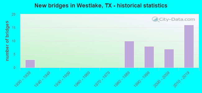
- New bridges - historical statistics
- 31930-1939
- 101980-1989
- 81990-1999
- 72000-2009
- 162010-2019
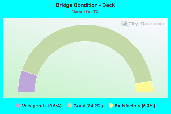
- Bridge Condition - Deck
- 10.5%Very good
- 84.2%Good
- 5.3%Satisfactory
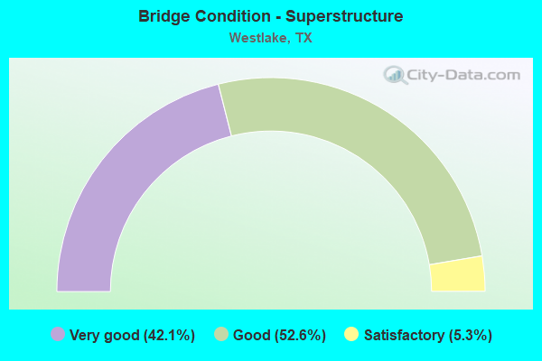
- Bridge Condition - Superstructure
- 42.1%Very good
- 52.6%Good
- 5.3%Satisfactory
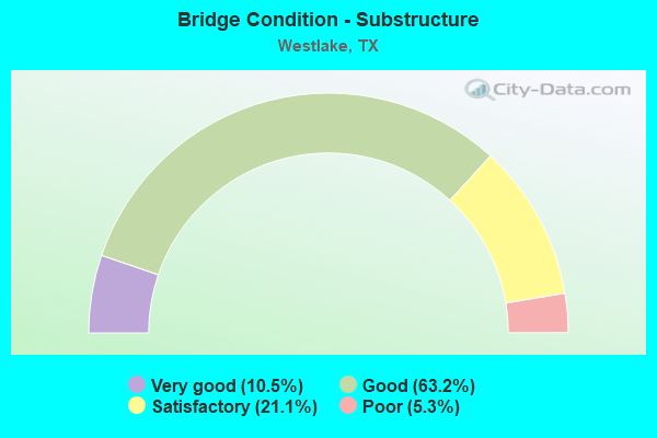
- Bridge Condition - Substructure
- 10.5%Very good
- 63.2%Good
- 21.1%Satisfactory
- 5.3%Poor
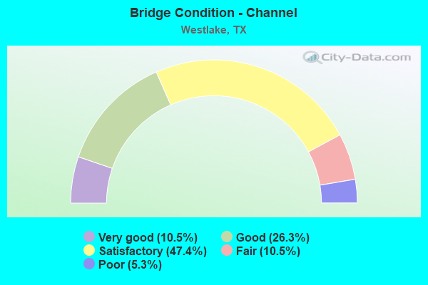
- Bridge Condition - Channel
- 10.5%Very good
- 26.3%Good
- 47.4%Satisfactory
- 10.5%Fair
- 5.3%Poor
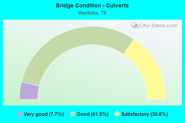
- Bridge Condition - Culverts
- 7.7%Very good
- 61.5%Good
- 30.8%Satisfactory
Find on map >> Show street view
Structure Number: 2220000810203, Location: .3 MI N OF FM 1709 (Lat: 32.975739, Lng: -97.243208), Route carried "on" structure: US 377, Year Built: 2009, Status: Open, Structure Length: 1.16m (3.81ft), Average Daily Traffic: 19,486 (year 2020), Truck Traffic: 11%, Average Future Daily Traffic: 23,640 (year 2029), Design Load: HS 20, Features Intersected: TRIB TO MARSHALL BRANCH
Minimum Vertical Clearance: 30+ m (98+ ft), Kilometerpoint: 0.370, Lanes on structure: 4, Base Highway Network: Yes, Owner: State Highway Agency, Approaching Roadway Width: 15.9m (52.2ft), Skew: 20 degrees, Material/Design: Concrete, Design/Construction: Culvert, Number Of Spans In Main Unit: 4, Length of Maximum Span: 2.4m (7.9ft), Curb-To-Curb Width: 15.9m (52.2ft), Out-to-Out Width: 34.4m (112.9ft)
Condition: Channel: Very good, Culverts: Good, Operating Rating: 44.4 metric tons, Method Used To Determine Operating Rating: No rating analysis performed, Inventory Rating: 32.7 metric tons, Method Used To Determine Inventory Rating: No rating analysis performed, Structural Evaluation: Better than present minimum criteria, Deck Geometry: Meets minimum limits, Waterway Adequacy: Equal to present desirable criteria, Approach Roadway Alignment: Equal to present desirable criteria, Designated Inspection Frequency: Every 48 months, Inspection Date: May 2018
Find on map >> Show street view
Structure Number: 22200008102173, Location: 4.75 MI E OF IH 35 (Lat: 32.985203, Lng: -97.236672), Route carried "on" structure: US 377, Year Built: 1992, Status: Open, Structure Length: 10.58m (34.71ft), Average Daily Traffic: 19,486 (year 2020), Truck Traffic: 8%, Average Future Daily Traffic: 29,390 (year 2033), Design Load: HS 20, Features Intersected: Future SH 170
Minimum Vertical Clearance: 30+ m (98+ ft), Kilometerpoint: 32.396, Lanes on structure: 6, Base Highway Network: Yes, Owner: State Highway Agency, Approaching Roadway Width: 29.9m (98.1ft), Skew: 32 degrees, Material/Design: Prestressed concrete, Design/Construction: Stringer/Multi-beam, Number Of Spans In Main Unit: 2, Number Of Approach Spans: 2, Length of Maximum Span: 35.1m (115.2ft), Curb-To-Curb Width: 28.0m (91.9ft), Out-to-Out Width: 29.9m (98.1ft)
Condition: Deck: Good, Superstructure: Good, Substructure: Good, Operating Rating: 54.4 metric tons, Method Used To Determine Operating Rating: Assigned rating based on Load Factor Design (LFD) reported in metric tons, Inventory Rating: 32.7 metric tons, Method Used To Determine Inventory Rating: Assigned rating based on Load Factor Design (LFD) reported in metric tons, Structural Evaluation: Better than present minimum criteria, Deck Geometry: Superior to present desirable criteria, Approach Roadway Alignment: Equal to present desirable criteria, Designated Inspection Frequency: Every 24 months, Inspection Date: May 2020, Deck Structure Type: Concrete Precast Panels
Find on map >> Show street view
Structure Number: 22200008102174, Location: 0.5 MI S OF SH 170 (Lat: 32.980192, Lng: -97.240972), Route carried "on" structure: US 377, Year Built: 1994, Status: Open, Structure Length: 1.34m (4.40ft), Average Daily Traffic: 19,486 (year 2020), Truck Traffic: 8%, Average Future Daily Traffic: 29,390 (year 2033), Design Load: HS 20, Features Intersected: TRIB MARSHALL BRANCH
Minimum Vertical Clearance: 30+ m (98+ ft), Kilometerpoint: 33.180, Lanes on structure: 5, Base Highway Network: Yes, Owner: State Highway Agency, Approaching Roadway Width: 25.6m (84.0ft), Material/Design: Concrete, Design/Construction: Culvert, Number Of Spans In Main Unit: 5, Length of Maximum Span: 2.1m (6.9ft)
Condition: Channel: Fair, Culverts: Good, Operating Rating: 39.9 metric tons, Method Used To Determine Operating Rating: Load Factor (LF), Inventory Rating: 23.6 metric tons, Method Used To Determine Inventory Rating: Load Factor (LF), Structural Evaluation: Somewhat better than minimum adequacy, Waterway Adequacy: Equal to present desirable criteria, Approach Roadway Alignment: Equal to present desirable criteria, Designated Inspection Frequency: Every 24 months, Inspection Date: May 2020
Find on map >> Show street view
Structure Number: 22200035303013, Location: 0.2 MI SE OF KIRKLAND (Lat: 32.979747, Lng: -97.165342), Route carried "on" structure: State highway 114, Year Built: 1930, Year Reconstructed: 2002, Status: Open, Structure Length: 2.29m (7.51ft), Average Daily Traffic: 108,140 (year 2019), Truck Traffic: 8%, Average Future Daily Traffic: 105,690 (year 2033), Features Intersected: KIRKWOOD BRANCH
Minimum Vertical Clearance: 30+ m (98+ ft), Kilometerpoint: 2.451, Lanes on structure: 8, Base Highway Network: Yes, Owner: State Highway Agency, Approaching Roadway Width: 34.1m (111.9ft), Skew: 39 degrees, Material/Design: Concrete, Design/Construction: Culvert, Number Of Spans In Main Unit: 7, Length of Maximum Span: 3.0m (9.8ft)
Condition: Channel: Satisfactory, Culverts: Satisfactory, Operating Rating: 39.9 metric tons, Method Used To Determine Operating Rating: Load Factor (LF), Inventory Rating: 23.6 metric tons, Method Used To Determine Inventory Rating: Load Factor (LF), Structural Evaluation: Somewhat better than minimum adequacy, Waterway Adequacy: Equal to present minimum criteria, Approach Roadway Alignment: Equal to present desirable criteria, Designated Inspection Frequency: Every 24 months, Inspection Date: May 2020
Find on map >> Show street view
Structure Number: 22200035303203, Location: 4.1 MI N OF FM 1709 (Lat: 32.981811, Lng: -97.167158), Route carried "on" structure: State highway 114, Year Built: 1988, Status: Open, Structure Length: 5.36m (17.59ft), Average Daily Traffic: 37,740 (year 2013), Truck Traffic: 8%, Average Future Daily Traffic: 52,840 (year 2033), Design Load: HS 20, Features Intersected: W KIRKWOOD BLVD
Minimum Vertical Clearance: 30+ m (98+ ft), Kilometerpoint: 2.029, Lanes on structure: 3, Lanes under structure: 6, Owner: State Highway Agency, Approaching Roadway Width: 17.1m (56.1ft), Material/Design: Prestressed concrete, Design/Construction: Stringer/Multi-beam, Number Of Spans In Main Unit: 3, Length of Maximum Span: 19.5m (64.0ft), Curb-To-Curb Width: 17.1m (56.1ft), Out-to-Out Width: 17.9m (58.7ft)
Condition: Deck: Good, Superstructure: Very good, Substructure: Very good, Operating Rating: 54.4 metric tons, Method Used To Determine Operating Rating: Assigned rating based on Load Factor Design (LFD) reported in metric tons, Inventory Rating: 32.7 metric tons, Method Used To Determine Inventory Rating: Assigned rating based on Load Factor Design (LFD) reported in metric tons, Structural Evaluation: Equal to present desirable criteria, Deck Geometry: Equal to present minimum criteria, Underclear: Better than present minimum criteria, Approach Roadway Alignment: Equal to present desirable criteria, Designated Inspection Frequency: Every 24 months, Inspection Date: May 2020, Deck Structure Type: Concrete Cast-file-Place
Find on map >> Show street view
Structure Number: 22200035303204, Location: 4.1 MI NW OF FM 1709 (Lat: 32.981839, Lng: -97.167131), Route carried "on" structure: State highway 114, Year Built: 1988, Status: Open, Structure Length: 5.36m (17.59ft), Average Daily Traffic: 37,740 (year 2013), Truck Traffic: 8%, Average Future Daily Traffic: 52,840 (year 2033), Design Load: HS 20, Features Intersected: W KIRKWOOD BLVD
Minimum Vertical Clearance: 30+ m (98+ ft), Kilometerpoint: 2.029, Lanes on structure: 3, Lanes under structure: 6, Base Highway Network: Yes, Owner: State Highway Agency, Approaching Roadway Width: 17.1m (56.1ft), Material/Design: Prestressed concrete, Design/Construction: Stringer/Multi-beam, Number Of Spans In Main Unit: 3, Length of Maximum Span: 19.5m (64.0ft), Curb-To-Curb Width: 17.1m (56.1ft), Out-to-Out Width: 17.9m (58.7ft)
Condition: Deck: Very good, Superstructure: Very good, Substructure: Very good, Operating Rating: 54.4 metric tons, Method Used To Determine Operating Rating: Assigned rating based on Load Factor Design (LFD) reported in metric tons, Inventory Rating: 32.7 metric tons, Method Used To Determine Inventory Rating: Assigned rating based on Load Factor Design (LFD) reported in metric tons, Structural Evaluation: Equal to present desirable criteria, Deck Geometry: Equal to present minimum criteria, Underclear: Better than present minimum criteria, Approach Roadway Alignment: Equal to present desirable criteria, Designated Inspection Frequency: Every 24 months, Inspection Date: May 2020, Deck Structure Type: Concrete Cast-file-Place
Find on map >> Show street view
Structure Number: 2220003530346, Location: 3.0 Miles E of US 377 (Lat: 32.989264, Lng: -97.181553), Route carried "on" structure: City street , Year Built: 2004, Status: Open, Structure Length: 5.00m (16.40ft), Average Daily Traffic: 3,400 (year 2015), Average Future Daily Traffic: 3,700 (year 2035), Design Load: HS 20, Features Intersected: SH 114, Facility Carried by Structure: Davis Blvd NB
Minimum Vertical Clearance: 30+ m (98+ ft), Kilometerpoint: 0.016, Lanes on structure: 3, Lanes under structure: 5, Owner: State Highway Agency, Approaching Roadway Width: 8.5m (27.9ft), Skew: 20 degrees, Material/Design: Prestressed concrete, Design/Construction: Stringer/Multi-beam, Number Of Spans In Main Unit: 2, Length of Maximum Span: 27.1m (88.9ft), Curb-To-Curb Width: 8.5m (27.9ft), Out-to-Out Width: 18.3m (60.0ft)
Condition: Deck: Good, Superstructure: Very good, Substructure: Good, Operating Rating: 54.4 metric tons, Method Used To Determine Operating Rating: Assigned rating based on Load Factor Design (LFD) reported in metric tons, Inventory Rating: 32.7 metric tons, Method Used To Determine Inventory Rating: Assigned rating based on Load Factor Design (LFD) reported in metric tons, Structural Evaluation: Better than present minimum criteria, Deck Geometry: High priority of replacement, Underclear: High priority of corrective action, Approach Roadway Alignment: Equal to present desirable criteria, Designated Inspection Frequency: Every 24 months, Inspection Date: May 2020, Deck Structure Type: Concrete Precast Panels
Find on map >> Show street view
Structure Number: 22200035303461, Location: 3.0 Miles E of US 377 (Lat: 32.989336, Lng: -97.181747), Route carried "on" structure: City street , Year Built: 2004, Status: Open, Structure Length: 5.00m (16.40ft), Average Daily Traffic: 3,400 (year 2015), Average Future Daily Traffic: 3,700 (year 2035), Design Load: HS 20, Features Intersected: SH 114, Facility Carried by Structure: Davis Blvd SB
Minimum Vertical Clearance: 30+ m (98+ ft), Kilometerpoint: 0.016, Lanes on structure: 6, Lanes under structure: 7, Owner: State Highway Agency, Approaching Roadway Width: 15.2m (49.9ft), Skew: 20 degrees, Material/Design: Prestressed concrete, Design/Construction: Stringer/Multi-beam, Number Of Spans In Main Unit: 2, Length of Maximum Span: 27.1m (88.9ft), Curb-To-Curb Width: 15.2m (49.9ft), Out-to-Out Width: 18.6m (61.0ft)
Condition: Deck: Good, Superstructure: Good, Substructure: Good, Operating Rating: 54.4 metric tons, Method Used To Determine Operating Rating: Assigned rating based on Load Factor Design (LFD) reported in metric tons, Inventory Rating: 32.7 metric tons, Method Used To Determine Inventory Rating: Assigned rating based on Load Factor Design (LFD) reported in metric tons, Structural Evaluation: Better than present minimum criteria, Deck Geometry: High priority of replacement, Underclear: High priority of corrective action, Approach Roadway Alignment: Equal to present desirable criteria, Designated Inspection Frequency: Every 24 months, Inspection Date: May 2020, Deck Structure Type: Concrete Precast Panels
Find on map >> Show street view
Structure Number: 2220019780101, Location: 1.7 Mi. S. of SH-114 (Lat: 32.964781, Lng: -97.186031), Route carried "on" structure: State highway 1938, Year Built: 2013, Status: Open, Structure Length: 1.34m (4.40ft), Average Daily Traffic: 37,239 (year 2019), Average Future Daily Traffic: 39,460 (year 2033), Design Load: HS 20, Features Intersected: Kirkwood Branch
Minimum Vertical Clearance: 30+ m (98+ ft), Kilometerpoint: 0.000, Lanes on structure: 5, Owner: State Highway Agency, Approaching Roadway Width: 8.5m (27.9ft), Skew: 21 degrees, Material/Design: Concrete, Design/Construction: Culvert, Number Of Spans In Main Unit: 5, Length of Maximum Span: 2.4m (7.9ft), Curb or Sidewalk Widths: Left: 0.0m, Right: 1.8m (5.9ft), Out-to-Out Width: 43.7m (143.4ft)
Condition: Channel: Good, Culverts: Very good, Operating Rating: 54.4 metric tons, Method Used To Determine Operating Rating: Assigned rating based on Load Factor Design (LFD) reported in metric tons, Inventory Rating: 32.7 metric tons, Method Used To Determine Inventory Rating: Assigned rating based on Load Factor Design (LFD) reported in metric tons, Structural Evaluation: Equal to present desirable criteria, Waterway Adequacy: Equal to present desirable criteria, Approach Roadway Alignment: Equal to present desirable criteria, Designated Inspection Frequency: Every 48 months, Inspection Date: May 2020
Find on map >> Show street view
Structure Number: 22200NN0045001, Location: 0.40 MI SE OF SH 170 (Lat: 32.990392, Lng: -97.215733), Route carried "on" structure: City street , Year Built: 1989, Status: Open, Structure Length: 1.10m (3.61ft), Average Daily Traffic: 500 (year 2016), Truck Traffic: 5%, Average Future Daily Traffic: 550 (year 2036), Features Intersected: MARSHALL BRANCH, Facility Carried by Structure: J T OTTINGER RD
Minimum Vertical Clearance: 30+ m (98+ ft), Kilometerpoint: 0.624, Lanes on structure: 2, Owner: City or Municipal Highway Agency, Approaching Roadway Width: 5.8m (19.0ft), Skew: 1 degrees, Material/Design: Steel, Design/Construction: Stringer/Multi-beam, Number Of Spans In Main Unit: 1, Length of Maximum Span: 10.7m (35.1ft), Curb-To-Curb Width: 7.0m (23.0ft), Out-to-Out Width: 7.1m (23.3ft)
Condition: Deck: Satisfactory, Superstructure: Satisfactory, Substructure: Poor, Channel: Poor, Operating Rating: 44.4 metric tons, Method Used To Determine Operating Rating: Allowable Stress (AS), Inventory Rating: 32.7 metric tons, Method Used To Determine Inventory Rating: Allowable Stress (AS), Structural Evaluation: Meets minimum limits, Deck Geometry: Meets minimum limits, Waterway Adequacy: High priority of corrective action, Approach Roadway Alignment: Better than present minimum criteria, Designated Inspection Frequency: Every 24 months, Inspection Date: July 2020, Deck Structure Type: Concrete Cast-file-Place
Find on map >> Show street view
Structure Number: 22200NN0060001, Location: 0.73 MI W SH 114 (Lat: 32.970942, Lng: -97.171092), Route carried "on" structure: City street , Year Built: 1939, Status: Open, Structure Length: 0.94m (3.08ft), Average Daily Traffic: 6,280 (year 2016), Truck Traffic: 5%, Average Future Daily Traffic: 6,330 (year 2036), Features Intersected: HIGGINS BRANCH, Facility Carried by Structure: DOVE ROAD
Minimum Vertical Clearance: 30+ m (98+ ft), Kilometerpoint: 3.219, Lanes on structure: 2, Owner: City or Municipal Highway Agency, Approaching Roadway Width: 6.1m (20.0ft), Material/Design: Concrete, Design/Construction: Culvert, Number Of Spans In Main Unit: 4, Length of Maximum Span: 2.1m (6.9ft), Curb-To-Curb Width: 7.3m (24.0ft), Out-to-Out Width: 8.3m (27.2ft)
Condition: Channel: Good, Culverts: Satisfactory, Operating Rating: 39.9 metric tons, Method Used To Determine Operating Rating: Load Factor (LF), Inventory Rating: 23.6 metric tons, Method Used To Determine Inventory Rating: Load Factor (LF), Structural Evaluation: Somewhat better than minimum adequacy, Deck Geometry: High priority of replacement, Waterway Adequacy: Better than present minimum criteria, Approach Roadway Alignment: Equal to present desirable criteria, Length Of Structure Improvement: 0.94m (3.08ft), Designated Inspection Frequency: Every 24 months, Inspection Date: July 2020, Bridge Improvement Cost: $1,000, Total Project Cost: $1,000, Deck Structure Type: Concrete Cast-file-Place, Wearing Surface/Protective System: Wearing Surface: Bituminous
Find on map >> Show street view
Structure Number: 22200NN0065001, Location: 300 FT S OF W KIRKWOOD BL (Lat: 32.979364, Lng: -97.170883), Route carried "on" structure: City street , Year Built: 1987, Status: Open, Structure Length: 1.25m (4.10ft), Average Daily Traffic: 1,036 (year 2019), Average Future Daily Traffic: 1,890 (year 2036), Design Load: HS 20, Features Intersected: TRIB OF KIRKWOOD BRANCH, Facility Carried by Structure: SAM SCHOOL ROAD
Minimum Vertical Clearance: 30+ m (98+ ft), Kilometerpoint: 0.092, Lanes on structure: 4, Owner: City or Municipal Highway Agency, Approaching Roadway Width: 14.6m (47.9ft), Skew: 4 degrees, Material/Design: Concrete, Design/Construction: Culvert, Number Of Spans In Main Unit: 3, Length of Maximum Span: 2.7m (8.9ft)
Condition: Channel: Satisfactory, Culverts: Good, Operating Rating: 39.9 metric tons, Method Used To Determine Operating Rating: Load Factor (LF), Inventory Rating: 23.6 metric tons, Method Used To Determine Inventory Rating: Load Factor (LF), Structural Evaluation: Equal to present minimum criteria, Waterway Adequacy: Better than present minimum criteria, Approach Roadway Alignment: Equal to present desirable criteria, Designated Inspection Frequency: Every 24 months, Inspection Date: July 2020
Find on map >> Show street view
Structure Number: 22200NN0065002, Location: 0.3 MI S KIRKWOOD BLVD (Lat: 32.977319, Lng: -97.168264), Route carried "on" structure: City street , Year Built: 1986, Status: Open, Structure Length: 2.32m (7.61ft), Average Daily Traffic: 1,036 (year 2019), Average Future Daily Traffic: 1,890 (year 2036), Design Load: HS 20, Features Intersected: KIRKWOOD BRANCH, Facility Carried by Structure: SAM SCHOOL ROAD
Minimum Vertical Clearance: 30+ m (98+ ft), Kilometerpoint: 0.483, Lanes on structure: 4, Owner: City or Municipal Highway Agency, Approaching Roadway Width: 14.6m (47.9ft), Material/Design: Concrete, Design/Construction: Culvert, Number Of Spans In Main Unit: 7, Length of Maximum Span: 3.0m (9.8ft)
Condition: Channel: Satisfactory, Culverts: Good, Operating Rating: 39.9 metric tons, Method Used To Determine Operating Rating: Load Factor (LF), Inventory Rating: 23.6 metric tons, Method Used To Determine Inventory Rating: Load Factor (LF), Structural Evaluation: Equal to present minimum criteria, Waterway Adequacy: Better than present minimum criteria, Approach Roadway Alignment: Equal to present desirable criteria, Designated Inspection Frequency: Every 24 months, Inspection Date: July 2020, Deck Structure Type: Concrete Cast-file-Place
Find on map >> Show street view
Structure Number: 22200NN0070001, Location: 0.3 MI W OF SH 114 (Lat: 32.980308, Lng: -97.172169), Route carried "on" structure: City street , Year Built: 1986, Status: Open, Structure Length: 0.94m (3.08ft), Average Daily Traffic: 10,520 (year 2016), Average Future Daily Traffic: 10,570 (year 2036), Design Load: HS 20, Features Intersected: TRIB OF KIRKWOOD BRANCH, Facility Carried by Structure: W KIRKWOOD BLVD EB
Minimum Vertical Clearance: 30+ m (98+ ft), Kilometerpoint: 1.207, Lanes on structure: 3, Owner: City or Municipal Highway Agency, Approaching Roadway Width: 11.0m (36.1ft), Skew: 1 degrees, Material/Design: Concrete, Design/Construction: Culvert, Number Of Spans In Main Unit: 3, Length of Maximum Span: 2.7m (8.9ft)
Condition: Channel: Satisfactory, Culverts: Good, Operating Rating: 39.9 metric tons, Method Used To Determine Operating Rating: Load Factor (LF), Inventory Rating: 23.6 metric tons, Method Used To Determine Inventory Rating: Load Factor (LF), Structural Evaluation: Somewhat better than minimum adequacy, Waterway Adequacy: Equal to present minimum criteria, Approach Roadway Alignment: Equal to present desirable criteria, Length Of Structure Improvement: 0.85m (2.79ft), Designated Inspection Frequency: Every 24 months, Inspection Date: July 2020, Bridge Improvement Cost: $20,000, Roadway Improvement Cost: $5,000, Total Project Cost: $25,000
Find on map >> Show street view
Structure Number: 22200NN0070002, Location: 0.3 MI W OF SH 114 (Lat: 32.980558, Lng: -97.172256), Route carried "on" structure: City street , Year Built: 1986, Status: Open, Structure Length: 0.85m (2.79ft), Average Daily Traffic: 10,520 (year 2016), Average Future Daily Traffic: 10,570 (year 2036), Design Load: HS 20, Features Intersected: TRIB OF KIRKWOOD BRANCH, Facility Carried by Structure: W KIRKWOOD BLVD WB
Minimum Vertical Clearance: 30+ m (98+ ft), Kilometerpoint: 0.483, Lanes on structure: 3, Owner: City or Municipal Highway Agency, Approaching Roadway Width: 11.0m (36.1ft), Skew: 1 degrees, Material/Design: Concrete, Design/Construction: Culvert, Number Of Spans In Main Unit: 3, Length of Maximum Span: 2.4m (7.9ft)
Condition: Channel: Satisfactory, Culverts: Good, Operating Rating: 39.9 metric tons, Method Used To Determine Operating Rating: Load Factor (LF), Inventory Rating: 23.6 metric tons, Method Used To Determine Inventory Rating: Load Factor (LF), Structural Evaluation: Somewhat better than minimum adequacy, Waterway Adequacy: Equal to present minimum criteria, Approach Roadway Alignment: Equal to present desirable criteria, Length Of Structure Improvement: 0.85m (2.79ft), Designated Inspection Frequency: Every 24 months, Inspection Date: July 2020
Find on map >> Show street view
Structure Number: 22200NN0075001, Location: 55 FT E OF SAM SCHOOL RD (Lat: 32.979186, Lng: -97.170281), Route carried "on" structure: City street , Year Built: 1987, Status: Open, Structure Length: 4.27m (14.01ft), Average Daily Traffic: 100 (year 2016), Average Future Daily Traffic: 150 (year 2036), Design Load: HS 20, Features Intersected: TRIB OF KIRKWOOD BRANCH, Facility Carried by Structure: VILLAGE DRIVE
Minimum Vertical Clearance: 30+ m (98+ ft), Kilometerpoint: 0.016, Lanes on structure: 2, Owner: City or Municipal Highway Agency, Approaching Roadway Width: 10.4m (34.1ft), Skew: 1 degrees, Material/Design: Prestressed concrete, Design/Construction: Box Beam or Girders - Multiple, Number Of Spans In Main Unit: 1, Number Of Approach Spans: 2, Length of Maximum Span: 18.3m (60.0ft), Curb or Sidewalk Widths: Left: 2.0m (6.6ft), Right: 0.0m, Curb-To-Curb Width: 8.2m (26.9ft), Out-to-Out Width: 11.6m (38.1ft)
Condition: Deck: Very good, Superstructure: Good, Substructure: Satisfactory, Channel: Good, Operating Rating: 54.4 metric tons, Method Used To Determine Operating Rating: Assigned rating based on Load Factor Design (LFD) reported in metric tons, Inventory Rating: 32.7 metric tons, Method Used To Determine Inventory Rating: Assigned rating based on Load Factor Design (LFD) reported in metric tons, Structural Evaluation: Equal to present minimum criteria, Deck Geometry: Equal to present minimum criteria, Waterway Adequacy: Superior to present desirable criteria, Approach Roadway Alignment: Equal to present desirable criteria, Designated Inspection Frequency: Every 24 months, Inspection Date: July 2020, Deck Structure Type: Concrete Cast-file-Place, Wearing Surface/Protective System: Wearing Surface: Other
Find on map >> Show street view
Structure Number: 22200NN0080001, Location: 0.1 MI S OF SH 170 (Lat: 32.985158, Lng: -97.228825), Route carried "on" structure: City street , Year Built: 1939, Status: Open, Structure Length: 1.68m (5.51ft), Average Daily Traffic: 4,368 (year 2019), Truck Traffic: 5%, Average Future Daily Traffic: 3,730 (year 2036), Features Intersected: MARSHALL BRANCH, Facility Carried by Structure: ROANOKE ROAD
Minimum Vertical Clearance: 30+ m (98+ ft), Kilometerpoint: 0.402, Lanes on structure: 2, Owner: City or Municipal Highway Agency, Approaching Roadway Width: 6.1m (20.0ft), Skew: 4 degrees, Material/Design: Concrete, Design/Construction: Culvert, Number Of Spans In Main Unit: 5, Length of Maximum Span: 2.1m (6.9ft), Curb-To-Curb Width: 7.3m (24.0ft), Out-to-Out Width: 7.9m (25.9ft)
Condition: Channel: Satisfactory, Culverts: Satisfactory, Operating Rating: 32.7 metric tons, Method Used To Determine Operating Rating: Field evaluation and documented engineering judgment, Inventory Rating: 24.5 metric tons, Method Used To Determine Inventory Rating: Field evaluation and documented engineering judgment, Structural Evaluation: Equal to present minimum criteria, Deck Geometry: High priority of replacement, Waterway Adequacy: Better than present minimum criteria, Approach Roadway Alignment: Equal to present desirable criteria, Length Of Structure Improvement: 1.68m (5.51ft), Designated Inspection Frequency: Every 24 months, Inspection Date: July 2020, Bridge Improvement Cost: $3,000, Roadway Improvement Cost: $1,000, Total Project Cost: $4,000, Deck Structure Type: Concrete Cast-file-Place, Wearing Surface/Protective System: Wearing Surface: Bituminous
Find on map >> Show street view
Structure Number: 22200NN0700001, Location: 1.26 MI W OF DAVIS BLVD (Lat: 32.978375, Lng: -97.206981), Route carried "on" structure: City street , Year Built: 2013, Status: Open, Structure Length: 1.31m (4.30ft), Average Daily Traffic: 2,795 (year 2019), Truck Traffic: 1%, Average Future Daily Traffic: 2,500 (year 2036), Design Load: HL 93, Features Intersected: DRAINAGE DITCH, Facility Carried by Structure: DOVE RD
Minimum Vertical Clearance: 30+ m (98+ ft), Kilometerpoint: 0.000, Lanes on structure: 2, Owner: City or Municipal Highway Agency, Approaching Roadway Width: 7.9m (25.9ft), Material/Design: Concrete, Design/Construction: Culvert, Number Of Spans In Main Unit: 5, Length of Maximum Span: 2.1m (6.9ft), Curb or Sidewalk Widths: Left: 2.4m (7.9ft), Right: 0.0m
Condition: Channel: Very good, Culverts: Good, Operating Rating: 54.4 metric tons, Method Used To Determine Operating Rating: Assigned ratings based on Load and Resistance Factor Design (LRFD) reported in metric tons, Inventory Rating: 32.7 metric tons, Method Used To Determine Inventory Rating: Assigned ratings based on Load and Resistance Factor Design (LRFD) reported in metric tons, Structural Evaluation: Better than present minimum criteria, Waterway Adequacy: Superior to present desirable criteria, Approach Roadway Alignment: Equal to present desirable criteria, Designated Inspection Frequency: Every 24 months, Inspection Date: July 2020
Find on map >> Show street view
Structure Number: 180610035302222, Location: 1.40 MI E OF US 377 (Lat: 32.997181, Lng: -97.207925), Route carried "on" structure: City street , Year Built: 1994, Status: Open, Structure Length: 8.14m (26.71ft), Average Daily Traffic: 100 (year 2014), Average Future Daily Traffic: 150 (year 2034), Design Load: HS 20, Features Intersected: SH 114, Facility Carried by Structure: TROPHY LAKE DRIVE
Minimum Vertical Clearance: 30+ m (98+ ft), Kilometerpoint: 0.000, Lanes on structure: 5, Lanes under structure: 7, Owner: State Highway Agency, Approaching Roadway Width: 23.2m (76.1ft), Skew: 20 degrees, Material/Design: Steel continuous, Design/Construction: Stringer/Multi-beam, Number Of Spans In Main Unit: 1, Number Of Approach Spans: 1, Length of Maximum Span: 46.9m (153.9ft), Curb or Sidewalk Widths: Left: 2.4m (7.9ft), Right: 2.4m (7.9ft), Curb-To-Curb Width: 23.2m (76.1ft), Out-to-Out Width: 29.9m (98.1ft)
Condition: Deck: Good, Superstructure: Good, Substructure: Satisfactory, Operating Rating: 68.0 metric tons, Method Used To Determine Operating Rating: Load Factor (LF), Inventory Rating: 40.8 metric tons, Method Used To Determine Inventory Rating: Load Factor (LF), Structural Evaluation: Equal to present minimum criteria, Deck Geometry: Better than present minimum criteria, Underclear: Superior to present desirable criteria, Approach Roadway Alignment: Equal to present desirable criteria, Designated Inspection Frequency: Every 24 months, Inspection Date: October 2021, Deck Structure Type: Concrete Precast Panels
Find on map >> Show street view
Structure Number: 180610035302223, Location: 1.50 MI E OF US 377 (Lat: 32.997178, Lng: -97.205097), Route carried "on" structure: State highway 114, Year Built: 1994, Status: Open, Structure Length: 17.37m (56.99ft), Average Daily Traffic: 63,770 (year 2010), Truck Traffic: 8%, Average Future Daily Traffic: 130,350 (year 2030), Design Load: HS 20, Features Intersected: MARSHALL BRANCH CREEK
Minimum Vertical Clearance: 30+ m (98+ ft), Kilometerpoint: 32.465, Lanes on structure: 3, Owner: State Highway Agency, Approaching Roadway Width: 12.2m (40.0ft), Material/Design: Prestressed concrete, Design/Construction: Stringer/Multi-beam, Number Of Spans In Main Unit: 6, Number Of Approach Spans: 2, Length of Maximum Span: 24.4m (80.1ft), Curb-To-Curb Width: 11.9m (39.0ft), Out-to-Out Width: 12.8m (42.0ft)
Condition: Deck: Good, Superstructure: Good, Substructure: Good, Channel: Satisfactory, Operating Rating: 54.4 metric tons, Method Used To Determine Operating Rating: Assigned rating based on Load Factor Design (LFD) reported in metric tons, Inventory Rating: 32.7 metric tons, Method Used To Determine Inventory Rating: Assigned rating based on Load Factor Design (LFD) reported in metric tons, Structural Evaluation: Better than present minimum criteria, Deck Geometry: High priority of corrective action, Waterway Adequacy: Superior to present desirable criteria, Approach Roadway Alignment: Equal to present desirable criteria, Length Of Structure Improvement: 17.37m (56.99ft), Designated Inspection Frequency: Every 24 months, Inspection Date: September 2021, Bridge Improvement Cost: $44,000, Roadway Improvement Cost: $11,000, Total Project Cost: $55,000, Deck Structure Type: Concrete Precast Panels
Find on map >> Show street view
Structure Number: 180610035302224, Location: 1.50 MI E OF US 377 (Lat: 32.996133, Lng: -97.204714), Route carried "on" structure: State highway 114, Year Built: 1994, Status: Open, Structure Length: 16.58m (54.40ft), Average Daily Traffic: 63,770 (year 2010), Truck Traffic: 8%, Average Future Daily Traffic: 130,350 (year 2030), Design Load: HS 20, Features Intersected: MARSHALL BRANCH CREEK
Minimum Vertical Clearance: 30+ m (98+ ft), Kilometerpoint: 33.395, Lanes on structure: 3, Owner: State Highway Agency, Approaching Roadway Width: 12.2m (40.0ft), Skew: 2 degrees, Material/Design: Prestressed concrete, Design/Construction: Stringer/Multi-beam, Number Of Spans In Main Unit: 7, Length of Maximum Span: 23.8m (78.1ft), Curb-To-Curb Width: 11.9m (39.0ft), Out-to-Out Width: 12.8m (42.0ft)
Condition: Deck: Good, Superstructure: Good, Substructure: Satisfactory, Channel: Satisfactory, Operating Rating: 54.4 metric tons, Method Used To Determine Operating Rating: Assigned rating based on Load Factor Design (LFD) reported in metric tons, Inventory Rating: 32.7 metric tons, Method Used To Determine Inventory Rating: Assigned rating based on Load Factor Design (LFD) reported in metric tons, Structural Evaluation: Equal to present minimum criteria, Deck Geometry: High priority of corrective action, Waterway Adequacy: Superior to present desirable criteria, Approach Roadway Alignment: Equal to present desirable criteria, Length Of Structure Improvement: 16.58m (54.40ft), Designated Inspection Frequency: Every 24 months, Inspection Date: September 2021, Bridge Improvement Cost: $42,000, Roadway Improvement Cost: $11,000, Total Project Cost: $53,000, Deck Structure Type: Concrete Precast Panels
Find on map >> Show street view
Structure Number: 180610035302225, Location: 2.50 MI E OF US 377 (Lat: 32.991756, Lng: -97.187806), Route carried "on" structure: State highway 114, Year Built: 1994, Status: Open, Structure Length: 1.92m (6.30ft), Average Daily Traffic: 79,602 (year 2019), Truck Traffic: 8%, Average Future Daily Traffic: 100,090 (year 2033), Design Load: HS 20, Features Intersected: DRAW
Minimum Vertical Clearance: 30+ m (98+ ft), Kilometerpoint: 35.043, Lanes on structure: 11, Owner: State Highway Agency, Approaching Roadway Width: 60.7m (199.1ft), Skew: 31 degrees, Material/Design: Concrete, Design/Construction: Culvert, Number Of Spans In Main Unit: 7, Length of Maximum Span: 2.4m (7.9ft)
Condition: Channel: Satisfactory, Culverts: Satisfactory, Operating Rating: 44.4 metric tons, Method Used To Determine Operating Rating: No rating analysis performed, Inventory Rating: 32.7 metric tons, Method Used To Determine Inventory Rating: No rating analysis performed, Structural Evaluation: Equal to present minimum criteria, Waterway Adequacy: Equal to present minimum criteria, Approach Roadway Alignment: Equal to present desirable criteria, Designated Inspection Frequency: Every 48 months, Inspection Date: November 2021
Find on map >> Show street view
Structure Number: 180610035302227, Location: 2.20 MI E OF US 377 (Lat: 32.992842, Lng: -97.192258), Route carried "on" structure: City street , Year Built: 2001, Status: Open, Structure Length: 9.63m (31.59ft), Average Daily Traffic: 3,200 (year 2013), Average Future Daily Traffic: 5,800 (year 2033), Design Load: HS 20, Features Intersected: SH 114, Facility Carried by Structure: TROPHY CLUB DRIVE
Minimum Vertical Clearance: 30+ m (98+ ft), Kilometerpoint: 3.476, Lanes on structure: 6, Lanes under structure: 4, Owner: State Highway Agency, Approaching Roadway Width: 23.2m (76.1ft), Skew: 20 degrees, Material/Design: Prestressed concrete, Design/Construction: Stringer/Multi-beam, Number Of Spans In Main Unit: 2, Number Of Approach Spans: 2, Length of Maximum Span: 32.3m (106.0ft), Curb or Sidewalk Widths: Left: 2.4m (7.9ft), Right: 2.4m (7.9ft), Curb-To-Curb Width: 23.2m (76.1ft), Out-to-Out Width: 29.9m (98.1ft)
Condition: Deck: Good, Superstructure: Good, Substructure: Satisfactory, Operating Rating: 54.4 metric tons, Method Used To Determine Operating Rating: Assigned rating based on Load Factor Design (LFD) reported in metric tons, Inventory Rating: 32.7 metric tons, Method Used To Determine Inventory Rating: Assigned rating based on Load Factor Design (LFD) reported in metric tons, Structural Evaluation: Equal to present minimum criteria, Deck Geometry: Meets minimum limits, Underclear: Equal to present minimum criteria, Approach Roadway Alignment: Equal to present desirable criteria, Designated Inspection Frequency: Every 24 months, Inspection Date: October 2021, Deck Structure Type: Concrete Precast Panels
Find on map >> Show street view
Structure Number: 180610035302414, Location: 1.53 MI NORTH OF US 377 (Lat: 32.996697, Lng: -97.204528), Route carried "on" structure: State highway 114, Year Built: 2013, Status: Open, Structure Length: 18.14m (59.51ft), Average Daily Traffic: 35,740 (year 2013), Truck Traffic: 8%, Average Future Daily Traffic: 50,040 (year 2033), Design Load: HL 93, Features Intersected: MARSHALL CREEK
Minimum Vertical Clearance: 30+ m (98+ ft), Kilometerpoint: 33.428, Lanes on structure: 3, Owner: State Highway Agency, Approaching Roadway Width: 24.4m (80.1ft), Skew: 3 degrees, Material/Design: Prestressed concrete, Design/Construction: Stringer/Multi-beam, Number Of Spans In Main Unit: 4, Number Of Approach Spans: 2, Length of Maximum Span: 33.5m (109.9ft), Curb-To-Curb Width: 24.4m (80.1ft), Out-to-Out Width: 25.7m (84.3ft)
Condition: Deck: Good, Superstructure: Good, Substructure: Good, Channel: Good, Operating Rating: 54.4 metric tons, Method Used To Determine Operating Rating: Assigned ratings based on Load and Resistance Factor Design (LRFD) reported in metric tons, Inventory Rating: 32.7 metric tons, Method Used To Determine Inventory Rating: Assigned ratings based on Load and Resistance Factor Design (LRFD) reported in metric tons, Structural Evaluation: Better than present minimum criteria, Deck Geometry: Superior to present desirable criteria, Waterway Adequacy: Superior to present desirable criteria, Approach Roadway Alignment: Equal to present desirable criteria, Designated Inspection Frequency: Every 24 months, Inspection Date: October 2021, Deck Structure Type: Concrete Precast Panels
Find on map >> Show street view
Structure Number: 180610035302415, Location: 1.38 MI W OF FM 1938 (Lat: 33.000856, Lng: -97.215956), Route carried "on" structure: Ramp State highway 114, Year Built: 2014, Status: Open, Structure Length: 17.07m (56.00ft), Average Daily Traffic: 8,000 (year 2013), Average Future Daily Traffic: 10,306 (year 2033), Design Load: HL 93, Features Intersected: SH 114 ML
Minimum Vertical Clearance: 30+ m (98+ ft), Kilometerpoint: 17.820, Lanes on structure: 1, Lanes under structure: 4, Owner: State Highway Agency, Approaching Roadway Width: 12.2m (40.0ft), Skew: 16 degrees, Material/Design: Steel continuous, Design/Construction: Stringer/Multi-beam, Number Of Spans In Main Unit: 2, Number Of Approach Spans: 2, Length of Maximum Span: 57.9m (190.0ft), Curb-To-Curb Width: 11.6m (38.1ft), Out-to-Out Width: 12.2m (40.0ft)
Condition: Deck: Good, Superstructure: Good, Substructure: Good, Operating Rating: 54.4 metric tons, Method Used To Determine Operating Rating: Assigned ratings based on Load and Resistance Factor Design (LRFD) reported in metric tons, Inventory Rating: 32.7 metric tons, Method Used To Determine Inventory Rating: Assigned ratings based on Load and Resistance Factor Design (LRFD) reported in metric tons, Structural Evaluation: Better than present minimum criteria, Deck Geometry: Superior to present desirable criteria, Underclear: Equal to present desirable criteria, Approach Roadway Alignment: Equal to present desirable criteria, Designated Inspection Frequency: Every 24 months, Inspection Date: October 2021, Deck Structure Type: Concrete Cast-file-Place
Find on map >> Show street view
Structure Number: 180610035302416, Location: 1.53 MI E OF US 377 (Lat: 32.996456, Lng: -97.204531), Route carried "on" structure: State highway 114, Year Built: 2013, Status: Open, Structure Length: 18.14m (59.51ft), Average Daily Traffic: 63,770 (year 2010), Truck Traffic: 8%, Average Future Daily Traffic: 82,120 (year 2030), Design Load: HL 93, Features Intersected: MARSHALL CREEK
Minimum Vertical Clearance: 30+ m (98+ ft), Kilometerpoint: 33.428, Lanes on structure: 3, Owner: State Highway Agency, Approaching Roadway Width: 24.7m (81.0ft), Skew: 3 degrees, Material/Design: Prestressed concrete, Design/Construction: Stringer/Multi-beam, Number Of Spans In Main Unit: 4, Number Of Approach Spans: 2, Length of Maximum Span: 33.5m (109.9ft), Curb-To-Curb Width: 24.7m (81.0ft), Out-to-Out Width: 24.9m (81.7ft)
Condition: Deck: Good, Superstructure: Good, Substructure: Good, Channel: Good, Operating Rating: 54.4 metric tons, Method Used To Determine Operating Rating: Assigned ratings based on Load and Resistance Factor Design (LRFD) reported in metric tons, Inventory Rating: 32.7 metric tons, Method Used To Determine Inventory Rating: Assigned ratings based on Load and Resistance Factor Design (LRFD) reported in metric tons, Structural Evaluation: Better than present minimum criteria, Deck Geometry: Superior to present desirable criteria, Waterway Adequacy: Superior to present desirable criteria, Approach Roadway Alignment: Equal to present desirable criteria, Designated Inspection Frequency: Every 24 months, Inspection Date: October 2021, Deck Structure Type: Concrete Precast Panels
Find on map >> Show street view
Structure Number: 180610035302417, Location: 0.29 MI NW TROPHY LK DR (Lat: 32.999361, Lng: -97.212911), Route carried "on" structure: Ramp State highway 170, Year Built: 2012, Status: Open, Structure Length: 19.48m (63.91ft), Average Daily Traffic: 2,200 (year 2014), Average Future Daily Traffic: 2,500 (year 2034), Design Load: HL 93, Features Intersected: SH 170 WB CONN A, Facility Carried by Structure: SH 114
Minimum Vertical Clearance: 30+ m (98+ ft), Kilometerpoint: 1.788, Lanes on structure: 2, Lanes under structure: 6, Owner: State Highway Agency, Approaching Roadway Width: 8.5m (27.9ft), Skew: 9 degrees, Material/Design: Steel continuous, Design/Construction: Stringer/Multi-beam, Number Of Spans In Main Unit: 2, Number Of Approach Spans: 4, Length of Maximum Span: 50.3m (165.0ft), Curb-To-Curb Width: 11.5m (37.7ft), Out-to-Out Width: 12.2m (40.0ft)
Condition: Deck: Good, Superstructure: Very good, Substructure: Good, Operating Rating: 54.4 metric tons, Method Used To Determine Operating Rating: Assigned ratings based on Load and Resistance Factor Design (LRFD) reported in metric tons, Inventory Rating: 32.7 metric tons, Method Used To Determine Inventory Rating: Assigned ratings based on Load and Resistance Factor Design (LRFD) reported in metric tons, Structural Evaluation: Better than present minimum criteria, Deck Geometry: Superior to present desirable criteria, Underclear: Equal to present minimum criteria, Approach Roadway Alignment: Equal to present desirable criteria, Designated Inspection Frequency: Every 24 months, Inspection Date: November 2021, Deck Structure Type: Concrete Cast-file-Place, Wearing Surface/Protective System: Deck Protection: Epoxy Coated Reinforcing
Find on map >> Show street view
Structure Number: 180610035302418, Location: 0.23 MI NW TROPHY LK DR (Lat: 32.998217, Lng: -97.213542), Route carried "on" structure: Ramp State highway 114, Year Built: 2012, Status: Open, Structure Length: 13.75m (45.11ft), Average Daily Traffic: 570 (year 2013), Average Future Daily Traffic: 810 (year 2033), Design Load: HL 93, Features Intersected: SH 114 EBFR
Minimum Vertical Clearance: 30+ m (98+ ft), Kilometerpoint: 32.771, Lanes on structure: 2, Lanes under structure: 1, Owner: State Highway Agency, Approaching Roadway Width: 11.0m (36.1ft), Material/Design: Prestressed concrete, Design/Construction: Stringer/Multi-beam, Number Of Spans In Main Unit: 4, Length of Maximum Span: 35.7m (117.1ft), Curb-To-Curb Width: 10.9m (35.8ft), Out-to-Out Width: 11.6m (38.1ft)
Condition: Deck: Good, Superstructure: Very good, Substructure: Good, Operating Rating: 54.4 metric tons, Method Used To Determine Operating Rating: Assigned ratings based on Load and Resistance Factor Design (LRFD) reported in metric tons, Inventory Rating: 32.7 metric tons, Method Used To Determine Inventory Rating: Assigned ratings based on Load and Resistance Factor Design (LRFD) reported in metric tons, Structural Evaluation: Better than present minimum criteria, Deck Geometry: Better than present minimum criteria, Underclear: Equal to present minimum criteria, Approach Roadway Alignment: Equal to present desirable criteria, Designated Inspection Frequency: Every 24 months, Inspection Date: November 2021, Deck Structure Type: Concrete Cast-file-Place, Wearing Surface/Protective System: Deck Protection: Epoxy Coated Reinforcing
Find on map >> Show street view
Structure Number: 180610035302419, Location: 0.17 MI NW TROPHY LK DR (Lat: 32.998650, Lng: -97.210583), Route carried "on" structure: State highway 170, Year Built: 2013, Status: Open, Structure Length: 39.29m (128.90ft), Average Daily Traffic: 13,100 (year 2013), Truck Traffic: 6%, Average Future Daily Traffic: 18,350 (year 2033), Design Load: HL 93, Features Intersected: SH 114
Minimum Vertical Clearance: 30+ m (98+ ft), Kilometerpoint: 1.788, Lanes on structure: 1, Lanes under structure: 6, Owner: State Highway Agency, Approaching Roadway Width: 11.6m (38.1ft), Skew: 9 degrees, Material/Design: Steel continuous, Design/Construction: Stringer/Multi-beam, Number Of Spans In Main Unit: 2, Number Of Approach Spans: 8, Length of Maximum Span: 80.8m (265.1ft), Curb-To-Curb Width: 11.3m (37.1ft), Out-to-Out Width: 12.2m (40.0ft)
Condition: Deck: Good, Superstructure: Very good, Substructure: Good, Operating Rating: 54.4 metric tons, Method Used To Determine Operating Rating: Assigned ratings based on Load and Resistance Factor Design (LRFD) reported in metric tons, Inventory Rating: 32.7 metric tons, Method Used To Determine Inventory Rating: Assigned ratings based on Load and Resistance Factor Design (LRFD) reported in metric tons, Structural Evaluation: Better than present minimum criteria, Deck Geometry: Meets minimum limits, Underclear: Somewhat better than minimum adequacy, Approach Roadway Alignment: Equal to present desirable criteria, Designated Inspection Frequency: Every 24 months, Inspection Date: November 2021, Deck Structure Type: Concrete Cast-file-Place, Wearing Surface/Protective System: Deck Protection: Epoxy Coated Reinforcing
Find on map >> Show street view
Structure Number: 180610355901174, Location: 0.8 Mi SW of SH 114 (Lat: 32.991169, Lng: -97.223450), Route carried "on" structure: State highway 170, Year Built: 2017, Status: Open, Structure Length: 10.67m (35.01ft), Average Daily Traffic: 28,000 (year 2018), Truck Traffic: 1%, Average Future Daily Traffic: 29,000 (year 2038), Design Load: HL 93, Features Intersected: Parish Ln
Minimum Vertical Clearance: 30+ m (98+ ft), Kilometerpoint: 0.483, Lanes on structure: 2, Lanes under structure: 10, Owner: State Highway Agency, Approaching Roadway Width: 17.1m (56.1ft), Material/Design: Prestressed concrete, Design/Construction: Stringer/Multi-beam, Number Of Spans In Main Unit: 3, Length of Maximum Span: 36.6m (120.1ft), Curb-To-Curb Width: 20.4m (66.9ft), Out-to-Out Width: 21.3m (69.9ft)
Condition: Deck: Good, Superstructure: Very good, Substructure: Good, Operating Rating: 54.4 metric tons, Method Used To Determine Operating Rating: Assigned ratings based on Load and Resistance Factor Design (LRFD) reported in metric tons, Inventory Rating: 32.7 metric tons, Method Used To Determine Inventory Rating: Assigned ratings based on Load and Resistance Factor Design (LRFD) reported in metric tons, Structural Evaluation: Better than present minimum criteria, Deck Geometry: Superior to present desirable criteria, Underclear: Meets minimum limits, Approach Roadway Alignment: Equal to present desirable criteria, Designated Inspection Frequency: Every 24 months, Inspection Date: July 2020, Deck Structure Type: Concrete Cast-file-Place, Wearing Surface/Protective System: Deck Protection: Epoxy Coated Reinforcing
Find on map >> Show street view
Structure Number: 180610355901175, Location: 0.8 Mi SW of SH 114 (Lat: 32.992200, Lng: -97.223150), Route carried "on" structure: State highway 170, Year Built: 2017, Status: Open, Structure Length: 10.67m (35.01ft), Average Daily Traffic: 28,000 (year 2018), Truck Traffic: 1%, Average Future Daily Traffic: 29,000 (year 2038), Design Load: HL 93, Features Intersected: Parish Ln
Minimum Vertical Clearance: 30+ m (98+ ft), Kilometerpoint: 0.483, Lanes on structure: 1, Lanes under structure: 10, Owner: State Highway Agency, Approaching Roadway Width: 17.1m (56.1ft), Material/Design: Prestressed concrete, Design/Construction: Stringer/Multi-beam, Number Of Spans In Main Unit: 3, Length of Maximum Span: 36.6m (120.1ft), Curb-To-Curb Width: 20.4m (66.9ft), Out-to-Out Width: 21.3m (69.9ft)
Condition: Deck: Good, Superstructure: Very good, Substructure: Good, Operating Rating: 54.4 metric tons, Method Used To Determine Operating Rating: Assigned ratings based on Load and Resistance Factor Design (LRFD) reported in metric tons, Inventory Rating: 32.7 metric tons, Method Used To Determine Inventory Rating: Assigned ratings based on Load and Resistance Factor Design (LRFD) reported in metric tons, Structural Evaluation: Better than present minimum criteria, Deck Geometry: Superior to present desirable criteria, Underclear: Meets minimum limits, Approach Roadway Alignment: Equal to present desirable criteria, Designated Inspection Frequency: Every 24 months, Inspection Date: July 2020, Deck Structure Type: Concrete Cast-file-Place, Wearing Surface/Protective System: Deck Protection: Epoxy Coated Reinforcing
Find on map >> Show street view
Structure Number: 180610355902006, Location: 5.4 MI E of IH 35E (Lat: 32.988467, Lng: -97.225639), Route carried "on" structure: State highway 170, Year Built: 1992, Status: Open, Structure Length: 1.89m (6.20ft), Average Daily Traffic: 5,000 (year 2015), Truck Traffic: 10%, Average Future Daily Traffic: 5,000 (year 2035), Design Load: HS 20, Features Intersected: Trib. of Marshall Creek
Minimum Vertical Clearance: 30+ m (98+ ft), Kilometerpoint: 0.000, Lanes on structure: 5, Owner: State Highway Agency, Approaching Roadway Width: 24.4m (80.1ft), Skew: 12 degrees, Material/Design: Concrete, Design/Construction: Culvert, Number Of Spans In Main Unit: 6, Length of Maximum Span: 2.7m (8.9ft)
Condition: Channel: Fair, Culverts: Good, Operating Rating: 44.4 metric tons, Method Used To Determine Operating Rating: No rating analysis performed, Inventory Rating: 32.7 metric tons, Method Used To Determine Inventory Rating: No rating analysis performed, Structural Evaluation: Better than present minimum criteria, Waterway Adequacy: Superior to present desirable criteria, Approach Roadway Alignment: Equal to present desirable criteria, Designated Inspection Frequency: Every 24 months, Inspection Date: November 2021
Find on map >> Show street view
Structure Number: 22200035303203, Location: 4.1 MI N OF FM 1709 (Lat: 32.915000, Lng: -97.167386), Route carried "under" structure: City street , Year Built: 1988, Structure Length: 0. m, Average Daily Traffic: 10,520 (year 2014), Features Intersected: SH 114 EB, Facility Carried by Structure: SH-114 EB
Minimum Vertical Clearance: 4.93m (16.17ft), Kilometerpoint: 0.850, Lanes on structure: 3, Lanes under structure: 6, Material/Design: Prestressed concrete, Design/Construction: Stringer/Multi-beam, Length of Maximum Span: 19.5m (64.0ft)
Find on map >> Show street view
Structure Number: 22200035303204, Location: 4.1 MI NW OF FM 1709 (Lat: 32.982022, Lng: -97.166939), Route carried "under" structure: City street , Year Built: 1988, Structure Length: 0. m, Average Daily Traffic: 10,520 (year 2014), Features Intersected: SH 114 WB, Facility Carried by Structure: SH-114 WB
Minimum Vertical Clearance: 5.08m (16.67ft), Kilometerpoint: 0.885, Lanes on structure: 3, Lanes under structure: 6, Material/Design: Prestressed concrete, Design/Construction: Stringer/Multi-beam, Length of Maximum Span: 19.5m (64.0ft)
Find on map >> Show street view
Structure Number: 2220003530346, Location: 3.0 Miles E of US 377 (Lat: 32.989517, Lng: -97.181325), Route carried "under" structure: State highway 114, Year Built: 2004, Structure Length: 0. m, Average Daily Traffic: 75,490 (year 2013), Truck Traffic: 8%, Features Intersected: DAVIS BLVD NB, Facility Carried by Structure: Davis Blvd NB
Minimum Vertical Clearance: 5.61m (18.41ft), Kilometerpoint: 7.368, Lanes on structure: 3, Lanes under structure: 5, Material/Design: Prestressed concrete, Design/Construction: Stringer/Multi-beam, Length of Maximum Span: 27.1m (88.9ft)
Find on map >> Show street view
Structure Number: 22200035303461, Location: 3.0 Miles E of US 377 (Lat: 32.989253, Lng: -97.181881), Route carried "under" structure: State highway 114, Year Built: 2004, Structure Length: 0. m, Average Daily Traffic: 75,490 (year 2013), Truck Traffic: 8%, Features Intersected: DAVIS BLVD SB, Facility Carried by Structure: Davis Blvd SB
Minimum Vertical Clearance: 5.26m (17.26ft), Kilometerpoint: 7.337, Lanes on structure: 6, Lanes under structure: 7, Material/Design: Prestressed concrete, Design/Construction: Stringer/Multi-beam, Length of Maximum Span: 27.1m (88.9ft)
Find on map >> Show street view
Structure Number: 180610035302222, Location: 1.40 MI E OF US 377 (Lat: 32.997181, Lng: -97.207925), Route carried "under" structure: ServiceState highway 114, Year Built: 1994, Structure Length: 0. m, Average Daily Traffic: 48,840 (year 2013), Truck Traffic: 9%, Features Intersected: SH 114, Facility Carried by Structure: TROPHY LAKE DRIVE
Minimum Vertical Clearance: 5.18m (16.99ft), Kilometerpoint: 18.834, Material/Design: Steel continuous, Design/Construction: Stringer/Multi-beam, Length of Maximum Span: 46.9m (153.9ft)
Find on map >> Show street view
Structure Number: 180610035302227, Location: 2.20 MI E OF US 377 (Lat: 32.992842, Lng: -97.192258), Route carried "under" structure: State highway 114, Year Built: 2001, Structure Length: 0. m, Average Daily Traffic: 71,490 (year 2013), Truck Traffic: 8%, Features Intersected: SH 114, Facility Carried by Structure: TROPHY CLUB DRIVE
Minimum Vertical Clearance: 5.51m (18.08ft), Kilometerpoint: 16.169, Material/Design: Prestressed concrete, Design/Construction: Stringer/Multi-beam, Length of Maximum Span: 32.3m (106.0ft)
Find on map >> Show street view
Structure Number: 180610035302415, Location: 1.38 MI W OF FM 1938 (Lat: 33.000856, Lng: -97.215956), Route carried "under" structure: State highway 114, Year Built: 2014, Structure Length: 0. m, Average Daily Traffic: 38,490 (year 2013), Truck Traffic: 5%, Features Intersected: SH 114 ML
Minimum Vertical Clearance: 6.33m (20.77ft), Kilometerpoint: 17.820, Material/Design: Steel continuous, Design/Construction: Stringer/Multi-beam, Length of Maximum Span: 57.9m (190.0ft)
Find on map >> Show street view
Structure Number: 180610035302417, Location: 0.29 MI NW TROPHY LK DR (Lat: 32.999300, Lng: -97.212900), Route carried "under" structure: State highway 114, Year Built: 2012, Structure Length: 0. m, Average Daily Traffic: 71,490 (year 2013), Truck Traffic: 8%, Features Intersected: SH 170 WB CONN A
Minimum Vertical Clearance: 6.76m (22.18ft), Kilometerpoint: 32.771, Material/Design: Steel continuous, Design/Construction: Stringer/Multi-beam, Length of Maximum Span: 50.3m (165.0ft)
Find on map >> Show street view
Structure Number: 180610035302418, Location: 0.23 MI NW TROPHY LK DR (Lat: 32.998200, Lng: -97.213500), Route carried "under" structure: ServiceState highway 114, Year Built: 2012, Structure Length: 0. m, Average Daily Traffic: 2,400 (year 2014), Truck Traffic: 5%, Features Intersected: SH 114 EBFR
Minimum Vertical Clearance: 5.39m (17.68ft), Kilometerpoint: 33.210, Material/Design: Prestressed concrete, Design/Construction: Stringer/Multi-beam, Length of Maximum Span: 35.7m (117.1ft)
Find on map >> Show street view
Structure Number: 180610035302419, Location: 0.17 MI NW TROPHY LK DR (Lat: 32.998600, Lng: -97.210500), Route carried "under" structure: State highway 114, Year Built: 2013, Structure Length: 0. m, Average Daily Traffic: 71,490 (year 2013), Truck Traffic: 8%, Features Intersected: SH 114, Facility Carried by Structure: SH 170 WB
Minimum Vertical Clearance: 8.10m (26.57ft), Kilometerpoint: 32.996, Material/Design: Steel continuous, Design/Construction: Stringer/Multi-beam, Length of Maximum Span: 80.8m (265.1ft)
Find on map >> Show street view
Structure Number: 180610355901174, Location: 0.8 Mi SW of SH 114 (Lat: 32.991175, Lng: -97.223450), Route carried "under" structure: City street , Year Built: 2017, Structure Length: 0. m, Average Daily Traffic: 100 (year 2020), Truck Traffic: 3%, Features Intersected: Parish Ln, Facility Carried by Structure: SH 170 EB
Minimum Vertical Clearance: 6.22m (20.41ft), Kilometerpoint: 0.483, Lanes on structure: 2, Lanes under structure: 10, Material/Design: Prestressed concrete, Design/Construction: Stringer/Multi-beam, Length of Maximum Span: 36.6m (120.1ft)
Find on map >> Show street view
Structure Number: 180610355901175, Location: 0.8 Mi SW of SH 114 (Lat: 32.992208, Lng: -97.223158), Route carried "under" structure: City street , Year Built: 2017, Structure Length: 0. m, Average Daily Traffic: 100 (year 2020), Truck Traffic: 3%, Features Intersected: Parish Ln, Facility Carried by Structure: SH 170 WB
Minimum Vertical Clearance: 6.04m (19.82ft), Kilometerpoint: 0.483, Lanes on structure: 1, Lanes under structure: 10, Material/Design: Prestressed concrete, Design/Construction: Stringer/Multi-beam, Length of Maximum Span: 36.6m (120.1ft)