Bridge Statistics for Williamsburg, Massachusetts (MA)
Condition, Traffic, Stress, Structural Evaluation, Project Costs
- National Bridge Inventory (NBI) Statistics
- 17Number of bridges
- 92ft / 28.0mTotal length
- $23,391,000Total costs
- 63,838Total average daily traffic
- 5,144Total average daily truck traffic
- 76,992Total future (year 2031) average daily traffic
- National Bridge Inventory (NBI) Registered Bridges for Williamsburg
- No street view available for this location
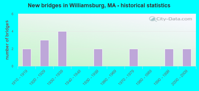
- New bridges - historical statistics
- 21910-1919
- 31920-1929
- 41930-1939
- 21950-1959
- 21970-1979
- 21990-1999
- 22000-2009
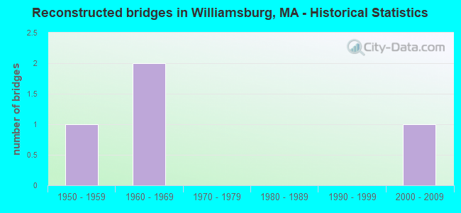
- Reconstructed bridges - Historical Statistics
- 11950-1959
- 21960-1969
- 01970-1979
- 01980-1989
- 01990-1999
- 12000-2009
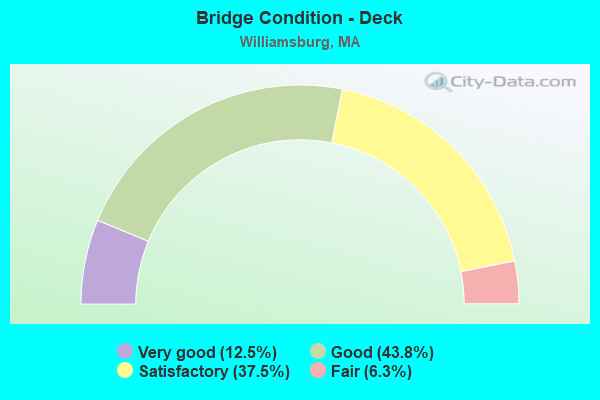
- Bridge Condition - Deck
- 12.5%Very good
- 43.8%Good
- 37.5%Satisfactory
- 6.3%Fair
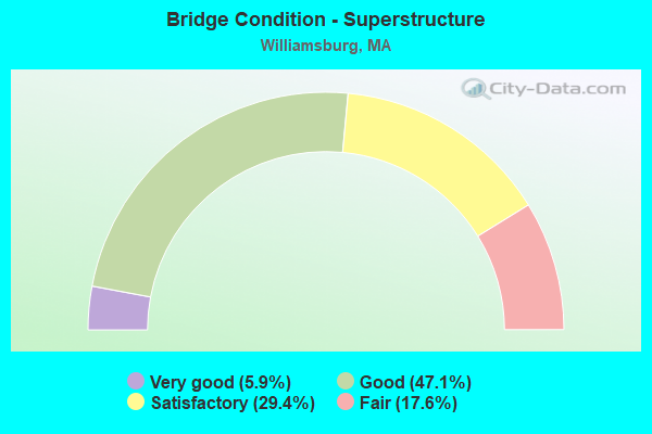
- Bridge Condition - Superstructure
- 5.9%Very good
- 47.1%Good
- 29.4%Satisfactory
- 17.6%Fair
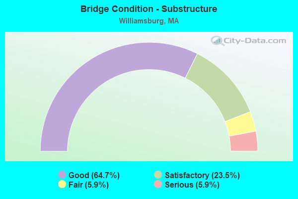
- Bridge Condition - Substructure
- 64.7%Good
- 23.5%Satisfactory
- 5.9%Fair
- 5.9%Serious
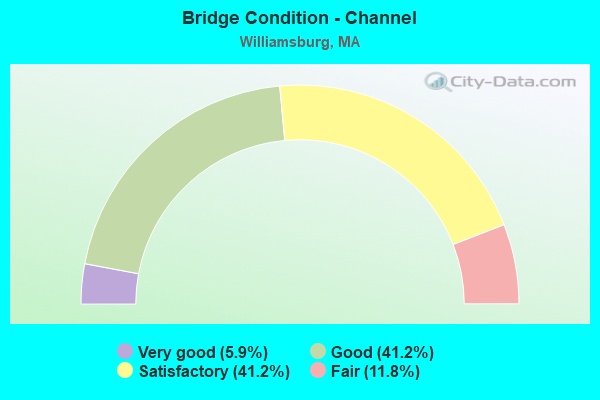
- Bridge Condition - Channel
- 5.9%Very good
- 41.2%Good
- 41.2%Satisfactory
- 11.8%Fair
Find on map >> Show street view
Structure Number: W360010K2DOTNBI, Location: .2 M W JCT ST 9 (Lat: 42.392658, Lng: -72.740467), Route carried "on" structure: State highway 143, Year Built: 1931, Year Reconstructed: 1964, Status: Open, Structure Length: 1.00m (3.28ft), Average Daily Traffic: 1,857 (year 2017), Truck Traffic: 7%, Average Future Daily Traffic: 2,843 (year 2032), Design Load: H 20, Features Intersected: WATER MEEKINS BROOK
Minimum Vertical Clearance: 30+ m (98+ ft), Kilometerpoint: 39.260, Lanes on structure: 2, Base Highway Network: Yes, Owner: State Highway Agency, Approaching Roadway Width: 10.0m (32.8ft), Skew: 2 degrees, Material/Design: Concrete, Design/Construction: Tee Beam, Number Of Spans In Main Unit: 1, Length of Maximum Span: 8.0m (26.2ft), Curb-To-Curb Width: 10.0m (32.8ft), Out-to-Out Width: 10.7m (35.1ft)
Condition: Deck: Good, Superstructure: Good, Substructure: Good, Channel: Satisfactory, Operating Rating: 66.4 metric tons, Method Used To Determine Operating Rating: Allowable Stress (AS), Inventory Rating: 39.7 metric tons, Method Used To Determine Inventory Rating: Allowable Stress (AS), Structural Evaluation: Better than present minimum criteria, Deck Geometry: Somewhat better than minimum adequacy, Waterway Adequacy: Equal to present desirable criteria, Approach Roadway Alignment: Equal to present desirable criteria, Length Of Structure Improvement: 1.10m (3.61ft), Designated Inspection Frequency: Every 24 months, Inspection Date: November 2021, Bridge Improvement Cost: $353,000, Roadway Improvement Cost: $36,000, Total Project Cost: $530,000 ( Estimate for 2022), Deck Structure Type: Concrete Cast-file-Place, Wearing Surface/Protective System: Wearing Surface: Bituminous, Membrane: Built-up
Find on map >> Show street view
Structure Number: W360030JBMUNNBI, Location: 100 FT S. JCT ASHFIELD RD (Lat: 42.431017, Lng: -72.742506), Route carried "on" structure: City street , Year Built: 1930, Year Reconstructed: 1966, Status: Posted for load, Structure Length: 0.81m (2.66ft), Average Daily Traffic: 129 (year 2017), Truck Traffic: 6%, Average Future Daily Traffic: 316 (year 2032), Features Intersected: WATER BRADFORD BROOK, Facility Carried by Structure: HWY HEMENWAY RD
Minimum Vertical Clearance: 30+ m (98+ ft), Kilometerpoint: 0.000, Lanes on structure: 2, Owner: Town or Township Highway Agency, Approaching Roadway Width: 6.1m (20.0ft), Skew: 1 degrees, Material/Design: Steel, Design/Construction: Stringer/Multi-beam, Number Of Spans In Main Unit: 1, Length of Maximum Span: 7.1m (23.3ft), Curb or Sidewalk Widths: Left: 0.5m (1.6ft), Right: 0.5m (1.6ft), Curb-To-Curb Width: 6.1m (20.0ft), Out-to-Out Width: 7.0m (23.0ft)
Condition: Deck: Fair, Superstructure: Satisfactory, Substructure: Good, Channel: Good, Operating Rating: 24.0 metric tons, Method Used To Determine Operating Rating: Allowable Stress (AS), Inventory Rating: 15.0 metric tons, Method Used To Determine Inventory Rating: Allowable Stress (AS), Structural Evaluation: Meets minimum limits, Deck Geometry: Meets minimum limits, Waterway Adequacy: Equal to present desirable criteria, Approach Roadway Alignment: Equal to present minimum criteria, Bridge Posting: Required (Relationship of Operating Rating to Maximum Legal Load: 20.0 - 29.9% below), Length Of Structure Improvement: 0.90m (2.95ft), Designated Inspection Frequency: Every 24 months, Inspection Date: November 2021, Bridge Improvement Cost: $248,000, Roadway Improvement Cost: $25,000, Total Project Cost: $373,000 ( Estimate for 2022), Deck Structure Type: Concrete Cast-file-Place
Find on map >> Show street view
Structure Number: W360040JRDOTNBI, Location: @ INT. W/ BUTTONSHOP RD. (Lat: 42.393650, Lng: -72.734233), Route carried "on" structure: State highway 9, Year Built: 1971, Status: Open, Structure Length: 1.74m (5.71ft), Average Daily Traffic: 8,250 (year 2014), Truck Traffic: 10%, Average Future Daily Traffic: 13,266 (year 2031), Design Load: H 20, Features Intersected: WATER W BR MILL RIVER
Minimum Vertical Clearance: 30+ m (98+ ft), Kilometerpoint: 55.183, Lanes on structure: 2, Base Highway Network: Yes, Owner: State Highway Agency, Approaching Roadway Width: 12.2m (40.0ft), Skew: 2 degrees, Material/Design: Prestressed concrete, Design/Construction: Stringer/Multi-beam, Number Of Spans In Main Unit: 1, Length of Maximum Span: 15.2m (49.9ft), Curb or Sidewalk Widths: Left: 1.8m (5.9ft), Right: 0.5m (1.6ft), Curb-To-Curb Width: 12.2m (40.0ft), Out-to-Out Width: 15.3m (50.2ft)
Condition: Deck: Satisfactory, Superstructure: Good, Substructure: Good, Channel: Satisfactory, Operating Rating: 59.6 metric tons, Method Used To Determine Operating Rating: Allowable Stress (AS), Inventory Rating: 24.7 metric tons, Method Used To Determine Inventory Rating: Allowable Stress (AS), Structural Evaluation: Equal to present minimum criteria, Deck Geometry: Somewhat better than minimum adequacy, Waterway Adequacy: Better than present minimum criteria, Approach Roadway Alignment: Equal to present desirable criteria, Length Of Structure Improvement: 1.80m (5.91ft), Designated Inspection Frequency: Every 24 months, Inspection Date: March 2022, Bridge Improvement Cost: $1,082,000, Roadway Improvement Cost: $109,000, Total Project Cost: $1,624,000 ( Estimate for 2022), Deck Structure Type: Concrete Cast-file-Place, Wearing Surface/Protective System: Wearing Surface: Bituminous, Membrane: Built-up
Find on map >> Show street view
Structure Number: W360060FFMUNNBI, Location: 230' N OF RTE 9 AT N MAIN (Lat: 42.393303, Lng: -72.730528), Route carried "on" structure: City street , Year Built: 1913, Status: Open, Structure Length: 1.28m (4.20ft), Average Daily Traffic: 2,365 (year 2017), Truck Traffic: 6%, Average Future Daily Traffic: 1,263 (year 2032), Features Intersected: WATER W BR MILL RIVER, Facility Carried by Structure: HWY NORTH ST
Minimum Vertical Clearance: 30+ m (98+ ft), Kilometerpoint: 0.064, Lanes on structure: 2, Owner: Town or Township Highway Agency, Approaching Roadway Width: 6.4m (21.0ft), Material/Design: Concrete, Design/Construction: Tee Beam, Number Of Spans In Main Unit: 1, Length of Maximum Span: 11.3m (37.1ft), Curb or Sidewalk Widths: Left: 1.8m (5.9ft), Right: 1.8m (5.9ft), Curb-To-Curb Width: 6.4m (21.0ft), Out-to-Out Width: 10.7m (35.1ft)
Condition: Deck: Satisfactory, Superstructure: Fair, Substructure: Good, Channel: Satisfactory, Operating Rating: 44.7 metric tons, Method Used To Determine Operating Rating: Load Factor (LF), Inventory Rating: 26.7 metric tons, Method Used To Determine Inventory Rating: Load Factor (LF), Structural Evaluation: Somewhat better than minimum adequacy, Deck Geometry: High priority of replacement, Waterway Adequacy: Better than present minimum criteria, Approach Roadway Alignment: High priority of corrective action, Length Of Structure Improvement: 1.30m (4.27ft), Designated Inspection Frequency: Every 24 months, Inspection Date: Febuary 2021, Bridge Improvement Cost: $547,000, Roadway Improvement Cost: $55,000, Total Project Cost: $821,000 ( Estimate for 2022), Deck Structure Type: Concrete Cast-file-Place, Wearing Surface/Protective System: Wearing Surface: Bituminous
Find on map >> Show street view
Structure Number: W360080J8MUNNBI, Location: @ VALLEY VIEW RD INT (Lat: 42.393372, Lng: -72.727925), Route carried "on" structure: City street , Year Built: 1972, Status: Open, Structure Length: 1.31m (4.30ft), Average Daily Traffic: 1,800 (year 2012), Truck Traffic: 15%, Average Future Daily Traffic: 316 (year 2031), Design Load: H 20, Features Intersected: WATER E BR MILL RIVER, Facility Carried by Structure: HWY E MAIN ST
Minimum Vertical Clearance: 30+ m (98+ ft), Kilometerpoint: 0.000, Lanes on structure: 2, Owner: Town or Township Highway Agency, Approaching Roadway Width: 9.1m (29.9ft), Material/Design: Prestressed concrete, Design/Construction: Slab, Number Of Spans In Main Unit: 1, Length of Maximum Span: 12.2m (40.0ft), Curb or Sidewalk Widths: Left: 1.5m (4.9ft), Right: 0.5m (1.6ft), Curb-To-Curb Width: 9.1m (29.9ft), Out-to-Out Width: 12.2m (40.0ft)
Condition: Deck: Satisfactory, Superstructure: Satisfactory, Substructure: Good, Channel: Satisfactory, Operating Rating: 51.9 metric tons, Method Used To Determine Operating Rating: Load Factor (LF), Inventory Rating: 31.1 metric tons, Method Used To Determine Inventory Rating: Load Factor (LF), Structural Evaluation: Equal to present minimum criteria, Deck Geometry: Somewhat better than minimum adequacy, Waterway Adequacy: Better than present minimum criteria, Approach Roadway Alignment: Equal to present desirable criteria, Length Of Structure Improvement: 1.40m (4.59ft), Designated Inspection Frequency: Every 24 months, Inspection Date: August 2020, Bridge Improvement Cost: $671,000, Roadway Improvement Cost: $68,000, Total Project Cost: $1,007,000 ( Estimate for 2022), Deck Structure Type: Concrete Precast Panels, Wearing Surface/Protective System: Wearing Surface: Bituminous
Find on map >> Show street view
Structure Number: W360100B9DOTNBI, Location: AT JCT OF RIVER RD (Lat: 42.389378, Lng: -72.720453), Route carried "on" structure: State highway 9, Year Built: 1933, Status: Open, Structure Length: 2.44m (8.01ft), Average Daily Traffic: 15,400 (year 2013), Truck Traffic: 6%, Average Future Daily Traffic: 13,740 (year 2032), Features Intersected: WATER MILL RIVER
Minimum Vertical Clearance: 30+ m (98+ ft), Kilometerpoint: 59.866, Lanes on structure: 2, Base Highway Network: Yes, Owner: State Highway Agency, Approaching Roadway Width: 12.2m (40.0ft), Skew: 2 degrees, Material/Design: Concrete continuous, Design/Construction: Tee Beam, Number Of Spans In Main Unit: 2, Length of Maximum Span: 11.3m (37.1ft), Curb or Sidewalk Widths: Left: 1.5m (4.9ft), Right: 0.0m, Curb-To-Curb Width: 12.2m (40.0ft), Out-to-Out Width: 14.9m (48.9ft)
Condition: Deck: Satisfactory, Superstructure: Fair, Substructure: Satisfactory, Channel: Good, Operating Rating: 43.4 metric tons, Method Used To Determine Operating Rating: Load Factor (LF), Inventory Rating: 27.3 metric tons, Method Used To Determine Inventory Rating: Load Factor (LF), Structural Evaluation: Somewhat better than minimum adequacy, Deck Geometry: Somewhat better than minimum adequacy, Waterway Adequacy: Better than present minimum criteria, Approach Roadway Alignment: Better than present minimum criteria, Length Of Structure Improvement: 2.50m (8.20ft), Designated Inspection Frequency: Every 24 months, Inspection Date: Febuary 2021, Bridge Improvement Cost: $1,464,000, Roadway Improvement Cost: $147,000, Total Project Cost: $2,197,000 ( Estimate for 2022), Deck Structure Type: Concrete Cast-file-Place, Wearing Surface/Protective System: Wearing Surface: Bituminous
Find on map >> Show street view
Structure Number: W360110FEMUNNBI, Location: 200' S OF RTE 9 (Lat: 42.373486, Lng: -72.702514), Route carried "on" structure: City street , Year Built: 1918, Year Reconstructed: 1968, Status: Posted for load, Structure Length: 2.74m (8.99ft), Average Daily Traffic: 1,400 (year 2013), Truck Traffic: 9%, Average Future Daily Traffic: 9,476 (year 2032), Features Intersected: WATER MILL RIVER, Facility Carried by Structure: HWY BRIDGE ST
Minimum Vertical Clearance: 30+ m (98+ ft), Kilometerpoint: 0.000, Lanes on structure: 2, Owner: Town or Township Highway Agency, Approaching Roadway Width: 7.9m (25.9ft), Skew: 2 degrees, Material/Design: Steel continuous, Design/Construction: Stringer/Multi-beam, Number Of Spans In Main Unit: 2, Length of Maximum Span: 12.8m (42.0ft), Curb or Sidewalk Widths: Left: 1.2m (3.9ft), Right: 1.2m (3.9ft), Curb-To-Curb Width: 7.8m (25.6ft), Out-to-Out Width: 11.1m (36.4ft)
Condition: Deck: Good, Superstructure: Good, Substructure: Serious, Channel: Fair, Operating Rating: 25.3 metric tons, Method Used To Determine Operating Rating: Allowable Stress (AS), Inventory Rating: 22.5 metric tons, Method Used To Determine Inventory Rating: Allowable Stress (AS), Structural Evaluation: High priority of corrective action, Deck Geometry: Meets minimum limits, Waterway Adequacy: Superior to present desirable criteria, Approach Roadway Alignment: Equal to present desirable criteria, Bridge Posting: Required (Relationship of Operating Rating to Maximum Legal Load: 20.0 - 29.9% below), Length Of Structure Improvement: 3.70m (12.14ft), Designated Inspection Frequency: Every 6 months, Other Special Inspection Frequency: Every 6 months, Inspection Date: May 2020, Other Special Inspection Date: November 2021, Bridge Improvement Cost: $3,237,000, Roadway Improvement Cost: $324,000, Total Project Cost: $4,856,000 ( Estimate for 2022), Deck Structure Type: Concrete Cast-file-Place, Wearing Surface/Protective System: Wearing Surface: Bituminous
Find on map >> Show street view
Structure Number: W360120FGMUNNBI, Location: JUST N OF NORTHAMPTON (Lat: 42.368881, Lng: -72.701575), Route carried "on" structure: City street , Year Built: 1922, Status: Open, Structure Length: 1.98m (6.50ft), Average Daily Traffic: 1,200 (year 2016), Truck Traffic: 6%, Average Future Daily Traffic: 1,895 (year 2032), Features Intersected: WATER MILL RIVER, Facility Carried by Structure: HWY S MAIN ST
Minimum Vertical Clearance: 30+ m (98+ ft), Kilometerpoint: 0.000, Lanes on structure: 2, Owner: Town or Township Highway Agency, Approaching Roadway Width: 6.4m (21.0ft), Skew: 3 degrees, Material/Design: Concrete, Design/Construction: Arch - Deck, Number Of Spans In Main Unit: 1, Length of Maximum Span: 19.8m (65.0ft), Curb-To-Curb Width: 6.1m (20.0ft), Out-to-Out Width: 6.7m (22.0ft)
Condition: Superstructure: Fair, Substructure: Fair, Channel: Good, Operating Rating: 61.3 metric tons, Method Used To Determine Operating Rating: Load Factor (LF), Inventory Rating: 36.7 metric tons, Method Used To Determine Inventory Rating: Load Factor (LF), Structural Evaluation: Somewhat better than minimum adequacy, Deck Geometry: High priority of replacement, Waterway Adequacy: Equal to present desirable criteria, Approach Roadway Alignment: Equal to present desirable criteria, Length Of Structure Improvement: 2.00m (6.56ft), Designated Inspection Frequency: Every 24 months, Inspection Date: May 2020, Bridge Improvement Cost: $527,000, Roadway Improvement Cost: $53,000, Total Project Cost: $791,000 ( Estimate for 2022)
Find on map >> Show street view
Structure Number: W360130JUDOTNBI, Location: 300' E JCT OLD GOSHEN RD. (Lat: 42.402389, Lng: -72.745633), Route carried "on" structure: State highway 9, Year Built: 1926, Status: Open, Structure Length: 1.16m (3.81ft), Average Daily Traffic: 9,310 (year 2018), Truck Traffic: 10%, Average Future Daily Traffic: 9,476 (year 2031), Design Load: H 15, Features Intersected: WATER W BR MILL RIVER
Minimum Vertical Clearance: 30+ m (98+ ft), Kilometerpoint: 53.751, Lanes on structure: 2, Base Highway Network: Yes, Owner: State Highway Agency, Approaching Roadway Width: 8.8m (28.9ft), Material/Design: Concrete, Design/Construction: Tee Beam, Number Of Spans In Main Unit: 1, Length of Maximum Span: 10.7m (35.1ft), Curb or Sidewalk Widths: Left: 0.2m (0.7ft), Right: 0.2m (0.7ft), Curb-To-Curb Width: 9.2m (30.2ft), Out-to-Out Width: 10.6m (34.8ft)
Condition: Deck: Satisfactory, Superstructure: Satisfactory, Substructure: Satisfactory, Channel: Satisfactory, Operating Rating: 49.9 metric tons, Method Used To Determine Operating Rating: Load Factor (LF), Inventory Rating: 33.3 metric tons, Method Used To Determine Inventory Rating: Load Factor (LF), Structural Evaluation: Equal to present minimum criteria, Deck Geometry: High priority of corrective action, Waterway Adequacy: Equal to present desirable criteria, Approach Roadway Alignment: Equal to present minimum criteria, Length Of Structure Improvement: 1.20m (3.94ft), Designated Inspection Frequency: Every 24 months, Inspection Date: March 2022, Bridge Improvement Cost: $476,000, Roadway Improvement Cost: $48,000, Total Project Cost: $715,000 ( Estimate for 2022), Deck Structure Type: Concrete Cast-file-Place, Wearing Surface/Protective System: Wearing Surface: Bituminous, Membrane: Built-up
Find on map >> Show street view
Structure Number: W360140JVDOTNBI, Location: JCT NICHOLS RD. (Lat: 42.403422, Lng: -72.748628), Route carried "on" structure: State highway 9, Year Built: 1926, Status: Open, Structure Length: 1.58m (5.18ft), Average Daily Traffic: 9,569 (year 2018), Truck Traffic: 10%, Average Future Daily Traffic: 9,476 (year 2031), Design Load: H 15, Features Intersected: WATER W BR MILL RIVER
Minimum Vertical Clearance: 30+ m (98+ ft), Kilometerpoint: 53.456, Lanes on structure: 2, Base Highway Network: Yes, Owner: State Highway Agency, Approaching Roadway Width: 9.1m (29.9ft), Skew: 4 degrees, Material/Design: Concrete, Design/Construction: Tee Beam, Number Of Spans In Main Unit: 1, Length of Maximum Span: 13.7m (44.9ft), Curb-To-Curb Width: 9.1m (29.9ft), Out-to-Out Width: 10.5m (34.4ft)
Condition: Deck: Good, Superstructure: Satisfactory, Substructure: Satisfactory, Channel: Satisfactory, Operating Rating: 57.8 metric tons, Method Used To Determine Operating Rating: Load Factor (LF), Inventory Rating: 34.7 metric tons, Method Used To Determine Inventory Rating: Load Factor (LF), Structural Evaluation: Equal to present minimum criteria, Deck Geometry: High priority of corrective action, Waterway Adequacy: Better than present minimum criteria, Approach Roadway Alignment: Equal to present desirable criteria, Length Of Structure Improvement: 1.60m (5.25ft), Designated Inspection Frequency: Every 24 months, Inspection Date: March 2022, Bridge Improvement Cost: $649,000, Roadway Improvement Cost: $65,000, Total Project Cost: $974,000 ( Estimate for 2022), Deck Structure Type: Concrete Cast-file-Place, Wearing Surface/Protective System: Wearing Surface: Bituminous, Membrane: Built-up
Find on map >> Show street view
Structure Number: W36015ANBDOTNBI, Location: .1MI W OF JCT W/STRTE 143 (Lat: 42.395469, Lng: -72.739369), Route carried "on" structure: State highway 9, Year Built: 2002, Status: Open, Structure Length: 2.23m (7.32ft), Average Daily Traffic: 9,500 (year 2012), Truck Traffic: 6%, Average Future Daily Traffic: 9,476 (year 2031), Design Load: HS 20, Features Intersected: WATER W BR MILL RIVER
Minimum Vertical Clearance: 30+ m (98+ ft), Kilometerpoint: 54.620, Lanes on structure: 2, Owner: State Highway Agency, Approaching Roadway Width: 11.0m (36.1ft), Skew: 2 degrees, Material/Design: Steel, Design/Construction: Stringer/Multi-beam, Number Of Spans In Main Unit: 1, Length of Maximum Span: 21.0m (68.9ft), Curb or Sidewalk Widths: Left: 1.6m (5.2ft), Right: 0.1m (0.3ft), Curb-To-Curb Width: 11.0m (36.1ft), Out-to-Out Width: 13.4m (44.0ft)
Condition: Deck: Very good, Superstructure: Good, Substructure: Good, Channel: Very good, Operating Rating: 94.4 metric tons, Method Used To Determine Operating Rating: Load Factor (LF), Inventory Rating: 47.1 metric tons, Method Used To Determine Inventory Rating: Load Factor (LF), Structural Evaluation: Better than present minimum criteria, Deck Geometry: Meets minimum limits, Waterway Adequacy: Equal to present minimum criteria, Approach Roadway Alignment: Equal to present desirable criteria, Length Of Structure Improvement: 2.30m (7.55ft), Designated Inspection Frequency: Every 24 months, Inspection Date: December 2020, Bridge Improvement Cost: $521,000, Roadway Improvement Cost: $53,000, Total Project Cost: $782,000 ( Estimate for 2022), Deck Structure Type: Concrete Cast-file-Place, Wearing Surface/Protective System: Wearing Surface: Bituminous, Membrane: Preformed Fabric, Deck Protection: Epoxy Coated Reinforcing
Find on map >> Show street view
Structure Number: W360170J9MUNNBI, Location: SW OF RT9 .5MI N OF NHPTN (Lat: 42.374711, Lng: -72.703906), Route carried "on" structure: City street , Year Built: 1957, Status: Posted for load, Structure Length: 2.04m (6.69ft), Average Daily Traffic: 600 (year 2009), Truck Traffic: 6%, Average Future Daily Traffic: 948 (year 2032), Design Load: H 15, Features Intersected: WATER MILL RIVER, Facility Carried by Structure: HWY S MAIN ST
Minimum Vertical Clearance: 30+ m (98+ ft), Kilometerpoint: 0.000, Lanes on structure: 2, Owner: Town or Township Highway Agency, Approaching Roadway Width: 6.4m (21.0ft), Material/Design: Steel, Design/Construction: Stringer/Multi-beam, Number Of Spans In Main Unit: 1, Length of Maximum Span: 17.7m (58.1ft), Curb or Sidewalk Widths: Left: 0.3m (1.0ft), Right: 1.5m (4.9ft), Curb-To-Curb Width: 6.4m (21.0ft), Out-to-Out Width: 9.1m (29.9ft)
Condition: Deck: Satisfactory, Superstructure: Good, Substructure: Good, Channel: Good, Operating Rating: 33.2 metric tons, Method Used To Determine Operating Rating: Allowable Stress (AS), Inventory Rating: 15.8 metric tons, Method Used To Determine Inventory Rating: Allowable Stress (AS), Structural Evaluation: Meets minimum limits, Deck Geometry: High priority of corrective action, Waterway Adequacy: Equal to present desirable criteria, Approach Roadway Alignment: High priority of corrective action, Length Of Structure Improvement: 2.10m (6.89ft), Designated Inspection Frequency: Every 24 months, Inspection Date: May 2020, Bridge Improvement Cost: $751,000, Roadway Improvement Cost: $76,000, Total Project Cost: $1,127,000 ( Estimate for 2022), Deck Structure Type: Concrete Cast-file-Place
Find on map >> Show street view
Structure Number: W360180J7MUNNBI, Location: .2 MI E OF KELLOGG @RTE 9 (Lat: 42.382011, Lng: -72.714028), Route carried "on" structure: City street , Year Built: 1955, Year Reconstructed: 2009, Status: Open, Structure Length: 2.07m (6.79ft), Average Daily Traffic: 129 (year 2017), Truck Traffic: 6%, Average Future Daily Traffic: 316 (year 2032), Design Load: HS 20, Features Intersected: WATER MILL RIVER, Facility Carried by Structure: HWY SKNRVLLE RD
Minimum Vertical Clearance: 30+ m (98+ ft), Kilometerpoint: 0.000, Lanes on structure: 1, Owner: Town or Township Highway Agency, Approaching Roadway Width: 3.6m (11.8ft), Material/Design: Steel, Design/Construction: Stringer/Multi-beam, Number Of Spans In Main Unit: 1, Length of Maximum Span: 20.4m (66.9ft), Curb-To-Curb Width: 3.7m (12.1ft), Out-to-Out Width: 4.4m (14.4ft)
Condition: Deck: Very good, Superstructure: Very good, Substructure: Good, Channel: Good, Operating Rating: 81.6 metric tons, Method Used To Determine Operating Rating: Load Factor (LF), Inventory Rating: 48.9 metric tons, Method Used To Determine Inventory Rating: Load Factor (LF), Structural Evaluation: Better than present minimum criteria, Deck Geometry: High priority of replacement, Waterway Adequacy: Equal to present minimum criteria, Approach Roadway Alignment: High priority of corrective action, Length Of Structure Improvement: 2.90m (9.51ft), Designated Inspection Frequency: Every 24 months, Inspection Date: November 2021, Bridge Improvement Cost: $1,784,000, Roadway Improvement Cost: $179,000, Total Project Cost: $2,677,000 ( Estimate for 2022), Deck Structure Type: Corrugated Steel, Wearing Surface/Protective System: Wearing Surface: Bituminous
Find on map >> Show street view
Structure Number: W360210K1DOTNBI, Location: @ JCT. OF ROUTES 143 & 9 (Lat: 42.394392, Lng: -72.736981), Route carried "on" structure: State highway 143, Year Built: 1931, Status: Open, Structure Length: 1.16m (3.81ft), Average Daily Traffic: 1,942 (year 2014), Truck Traffic: 7%, Average Future Daily Traffic: 3,474 (year 2033), Design Load: H 20, Features Intersected: WATER W BR MILL RIVER
Minimum Vertical Clearance: 30+ m (98+ ft), Kilometerpoint: 39.669, Lanes on structure: 2, Base Highway Network: Yes, Owner: State Highway Agency, Approaching Roadway Width: 9.1m (29.9ft), Skew: 1 degrees, Material/Design: Concrete, Design/Construction: Tee Beam, Number Of Spans In Main Unit: 1, Length of Maximum Span: 10.7m (35.1ft), Curb or Sidewalk Widths: Left: 0.2m (0.7ft), Right: 0.2m (0.7ft), Curb-To-Curb Width: 9.1m (29.9ft), Out-to-Out Width: 10.2m (33.5ft)
Condition: Deck: Good, Superstructure: Satisfactory, Substructure: Satisfactory, Channel: Fair, Operating Rating: 68.5 metric tons, Method Used To Determine Operating Rating: Load Factor (LF), Inventory Rating: 41.0 metric tons, Method Used To Determine Inventory Rating: Load Factor (LF), Structural Evaluation: Equal to present minimum criteria, Deck Geometry: Somewhat better than minimum adequacy, Waterway Adequacy: Better than present minimum criteria, Approach Roadway Alignment: Equal to present desirable criteria, Length Of Structure Improvement: 1.20m (3.94ft), Designated Inspection Frequency: Every 24 months, Inspection Date: March 2022, Bridge Improvement Cost: $487,000, Roadway Improvement Cost: $49,000, Total Project Cost: $731,000 ( Estimate for 2022), Deck Structure Type: Concrete Cast-file-Place, Wearing Surface/Protective System: Wearing Surface: Bituminous, Membrane: Built-up
Find on map >> Show street view
Structure Number: W36027AF5MUNNBI, Location: 0.8MI E INT W/ RT9 & E ST (Lat: 42.421650, Lng: -72.764961), Route carried "on" structure: City street , Year Built: 1999, Status: Open, Structure Length: 1.50m (4.92ft), Average Daily Traffic: 129 (year 2017), Truck Traffic: 6%, Average Future Daily Traffic: 316 (year 2032), Design Load: HS 20, Features Intersected: WATER W BR MILL RIVER, Facility Carried by Structure: HWY OLD GOSHEN
Minimum Vertical Clearance: 30+ m (98+ ft), Kilometerpoint: 0.000, Lanes on structure: 2, Owner: Town or Township Highway Agency, Approaching Roadway Width: 6.0m (19.7ft), Skew: 1 degrees, Material/Design: Prestressed concrete, Design/Construction: Slab, Number Of Spans In Main Unit: 1, Length of Maximum Span: 13.4m (44.0ft), Curb-To-Curb Width: 6.0m (19.7ft), Out-to-Out Width: 7.1m (23.3ft)
Condition: Deck: Good, Superstructure: Good, Substructure: Good, Channel: Satisfactory, Operating Rating: 67.5 metric tons, Method Used To Determine Operating Rating: Load Factor (LF), Inventory Rating: 40.4 metric tons, Method Used To Determine Inventory Rating: Load Factor (LF), Structural Evaluation: Better than present minimum criteria, Deck Geometry: High priority of corrective action, Waterway Adequacy: Better than present minimum criteria, Approach Roadway Alignment: Equal to present desirable criteria, Length Of Structure Improvement: 1.60m (5.25ft), Designated Inspection Frequency: Every 24 months, Inspection Date: December 2021, Bridge Improvement Cost: $755,000, Roadway Improvement Cost: $76,000, Total Project Cost: $1,133,000 ( Estimate for 2022), Deck Structure Type: Concrete Precast Panels, Wearing Surface/Protective System: Wearing Surface: Bituminous, Membrane: Preformed Fabric, Deck Protection: Epoxy Coated Reinforcing
Find on map >> Show street view
Structure Number: W36028AF6MUNNBI, Location: 125' E OF INT W/ ROUTE 9 (Lat: 42.404506, Lng: -72.749972), Route carried "on" structure: City street , Year Built: 1999, Status: Open, Structure Length: 1.62m (5.31ft), Average Daily Traffic: 129 (year 2011), Truck Traffic: 6%, Average Future Daily Traffic: 316 (year 2032), Design Load: HS 20, Features Intersected: WATER W BR MILL RIVER, Facility Carried by Structure: HWY VILLAGE HILL
Minimum Vertical Clearance: 30+ m (98+ ft), Kilometerpoint: 0.000, Lanes on structure: 2, Owner: Town or Township Highway Agency, Approaching Roadway Width: 6.0m (19.7ft), Skew: 1 degrees, Material/Design: Prestressed concrete, Design/Construction: Slab, Number Of Spans In Main Unit: 1, Length of Maximum Span: 14.8m (48.6ft), Curb-To-Curb Width: 6.0m (19.7ft), Out-to-Out Width: 7.1m (23.3ft)
Condition: Deck: Good, Superstructure: Good, Substructure: Good, Channel: Good, Operating Rating: 64.8 metric tons, Method Used To Determine Operating Rating: Load Factor (LF), Inventory Rating: 38.8 metric tons, Method Used To Determine Inventory Rating: Load Factor (LF), Structural Evaluation: Better than present minimum criteria, Deck Geometry: High priority of corrective action, Waterway Adequacy: Equal to present minimum criteria, Approach Roadway Alignment: Equal to present desirable criteria, Length Of Structure Improvement: 1.70m (5.58ft), Designated Inspection Frequency: Every 24 months, Inspection Date: December 2021, Bridge Improvement Cost: $802,000, Roadway Improvement Cost: $81,000, Total Project Cost: $1,204,000 ( Estimate for 2022), Deck Structure Type: Concrete Precast Panels, Wearing Surface/Protective System: Wearing Surface: Bituminous, Membrane: Preformed Fabric, Deck Protection: Epoxy Coated Reinforcing
Find on map >> Show street view
Structure Number: W36029BGKMUNNBI, Location: 230'N OF RT143 (Lat: 42.389939, Lng: -72.754667), Route carried "on" structure: City street , Year Built: 2007, Status: Posted for load, Structure Length: 1.37m (4.49ft), Average Daily Traffic: 129 (year 2017), Truck Traffic: 1%, Average Future Daily Traffic: 79 (year 2033), Design Load: HS 20, Features Intersected: WATER MEEKIN BROOK, Facility Carried by Structure: HWY GEER HILL RD
Minimum Vertical Clearance: 30+ m (98+ ft), Kilometerpoint: 0.000, Lanes on structure: 1, Owner: Town or Township Highway Agency, Approaching Roadway Width: 4.5m (14.8ft), Material/Design: Steel, Design/Construction: Truss - Thru, Number Of Spans In Main Unit: 1, Length of Maximum Span: 12.2m (40.0ft), Curb-To-Curb Width: 3.4m (11.2ft), Out-to-Out Width: 3.6m (11.8ft)
Condition: Deck: Good, Superstructure: Good, Substructure: Good, Channel: Good, Operating Rating: 61.6 metric tons, Method Used To Determine Operating Rating: Load Factor (LF), Inventory Rating: 36.9 metric tons, Method Used To Determine Inventory Rating: Load Factor (LF), Structural Evaluation: Better than present minimum criteria, Deck Geometry: High priority of replacement, Waterway Adequacy: Superior to present desirable criteria, Approach Roadway Alignment: Somewhat better than minimum adequacy, Length Of Structure Improvement: 2.10m (6.89ft), Designated Inspection Frequency: Every 24 months, Critical Feature Inspection Frequency: Every 24 months, Inspection Date: December 2021, Critical Feature Inspection Date: December 2021, Bridge Improvement Cost: $1,232,000, Roadway Improvement Cost: $124,000, Total Project Cost: $1,849,000 ( Estimate for 2022), Deck Structure Type: Steel plate