Bridge Statistics for Willow, Alaska (AK)
Condition, Traffic, Stress, Structural Evaluation, Project Costs
- National Bridge Inventory (NBI) Statistics
- 13Number of bridges
- 328ft / 100mTotal length
- 26,783Total average daily traffic
- 4,308Total average daily truck traffic
- 33,824Total future (year 2035) average daily traffic
- National Bridge Inventory (NBI) Registered Bridges for Willow
- No street view available for this location
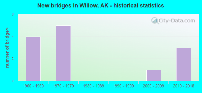
- New bridges - historical statistics
- 41960-1969
- 51970-1979
- 12000-2009
- 32010-2018
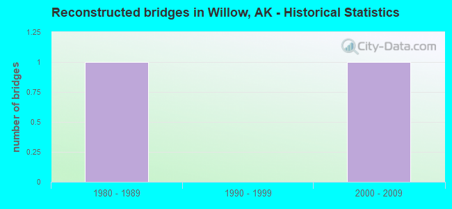
- Reconstructed bridges - Historical Statistics
- 11980-1989
- 01990-1999
- 12000-2009
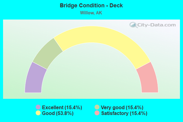
- Bridge Condition - Deck
- 15.4%Excellent
- 15.4%Very good
- 53.8%Good
- 15.4%Satisfactory
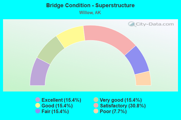
- Bridge Condition - Superstructure
- 15.4%Excellent
- 15.4%Very good
- 15.4%Good
- 30.8%Satisfactory
- 15.4%Fair
- 7.7%Poor
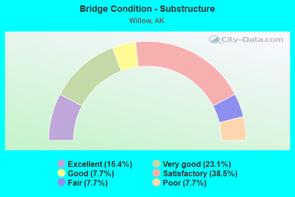
- Bridge Condition - Substructure
- 15.4%Excellent
- 23.1%Very good
- 7.7%Good
- 38.5%Satisfactory
- 7.7%Fair
- 7.7%Poor
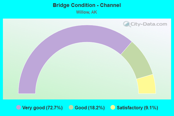
- Bridge Condition - Channel
- 72.7%Very good
- 18.2%Good
- 9.1%Satisfactory
Find on map >> Show street view
Structure Number: 211, Location: MILE POINT 39.8 (Lat: 61.809761, Lng: -150.097139), Route carried "on" structure: Interstate A41, Year Built: 1962, Status: Open, Structure Length: 4.22m (13.85ft), Average Daily Traffic: 3,332 (year 2016), Truck Traffic: 14%, Average Future Daily Traffic: 6,555 (year 2035), Design Load: HS 20, Features Intersected: LITTLE WILLOW CREEK, Facility Carried by Structure: PARKS HIGHWAY
Minimum Vertical Clearance: 5.41m (17.75ft), Kilometerpoint: 64.038, Lanes on structure: 2, Base Highway Network: Yes, Owner: State Highway Agency, Approaching Roadway Width: 98.0m (321.5ft), Material/Design: Prestressed concrete, Design/Construction: Stringer/Multi-beam, Number Of Spans In Main Unit: 1, Number Of Approach Spans: 2, Length of Maximum Span: 18.9m (62.0ft), Curb or Sidewalk Widths: Left: 0.5m (1.6ft), Right: 0.5m (1.6ft), Curb-To-Curb Width: 8.5m (27.9ft), Out-to-Out Width: 10.1m (33.1ft)
Condition: Deck: Satisfactory, Superstructure: Fair, Substructure: Satisfactory, Channel: Very good, Operating Rating: 52.3 metric tons, Method Used To Determine Operating Rating: Load Factor (LF), Inventory Rating: 2.4 metric tons, Method Used To Determine Inventory Rating: Load Factor (LF), Structural Evaluation: Somewhat better than minimum adequacy, Deck Geometry: Meets minimum limits, Waterway Adequacy: Equal to present desirable criteria, Approach Roadway Alignment: Equal to present desirable criteria, Designated Inspection Frequency: Every 24 months, Inspection Date: June 2016, Deck Structure Type: Concrete Cast-file-Place, Wearing Surface/Protective System: Wearing Surface: Bituminous
Find on map >> Show street view
Structure Number: 213, Location: MILE POINT 53.7 (Lat: 61.996181, Lng: -150.052925), Route carried "on" structure: Interstate A41, Year Built: 1962, Status: Open, Structure Length: 3.81m (12.50ft), Average Daily Traffic: 3,196 (year 2016), Truck Traffic: 14%, Average Future Daily Traffic: 3,300 (year 2035), Design Load: HS 20, Features Intersected: SHEEP CREEK, Facility Carried by Structure: PARKS HIGHWAY
Minimum Vertical Clearance: 5.41m (17.75ft), Kilometerpoint: 86.403, Lanes on structure: 2, Base Highway Network: Yes, Owner: State Highway Agency, Approaching Roadway Width: 98.0m (321.5ft), Material/Design: Prestressed concrete, Design/Construction: Stringer/Multi-beam, Number Of Spans In Main Unit: 1, Number Of Approach Spans: 2, Length of Maximum Span: 18.9m (62.0ft), Curb-To-Curb Width: 8.5m (27.9ft), Out-to-Out Width: 10.1m (33.1ft)
Condition: Deck: Good, Superstructure: Poor, Substructure: Good, Channel: Very good, Operating Rating: 52.6 metric tons, Method Used To Determine Operating Rating: Load Factor (LF), Inventory Rating: 24.2 metric tons, Method Used To Determine Inventory Rating: Load Factor (LF), Structural Evaluation: Meets minimum limits, Deck Geometry: Meets minimum limits, Waterway Adequacy: Equal to present desirable criteria, Approach Roadway Alignment: Equal to present desirable criteria, Designated Inspection Frequency: Every 24 months, Inspection Date: June 2016, Deck Structure Type: Concrete Cast-file-Place, Wearing Surface/Protective System: Wearing Surface: Bituminous
Find on map >> Show street view
Structure Number: 254, Location: MILE POINT 69.3 (Lat: 62.175633, Lng: -150.175111), Route carried "on" structure: Interstate A42, Year Built: 1965, Status: Open, Structure Length: 32.67m (107.19ft), Average Daily Traffic: 2,474 (year 2016), Truck Traffic: 16%, Average Future Daily Traffic: 2,500 (year 2035), Design Load: HS 20, Features Intersected: SUSITNA RIVER, Facility Carried by Structure: PARKS HIGHWAY
Minimum Vertical Clearance: 5.41m (17.75ft), Kilometerpoint: 111.504, Lanes on structure: 2, Base Highway Network: Yes, Owner: State Highway Agency, Approaching Roadway Width: 122.0m (400.3ft), Material/Design: Steel continuous, Design/Construction: Stringer/Multi-beam, Number Of Spans In Main Unit: 5, Length of Maximum Span: 76.2m (250.0ft), Curb or Sidewalk Widths: Left: 0.5m (1.6ft), Right: 0.5m (1.6ft), Curb-To-Curb Width: 9.1m (29.9ft), Out-to-Out Width: 10.3m (33.8ft)
Condition: Deck: Good, Superstructure: Satisfactory, Substructure: Satisfactory, Channel: Good, Operating Rating: 8.0 metric tons, Method Used To Determine Operating Rating: Load Factor (LF), Inventory Rating: 33.8 metric tons, Method Used To Determine Inventory Rating: Load Factor (LF), Structural Evaluation: Equal to present minimum criteria, Deck Geometry: Meets minimum limits, Waterway Adequacy: Equal to present desirable criteria, Approach Roadway Alignment: Equal to present minimum criteria, Designated Inspection Frequency: Every 24 months, Critical Feature Inspection Frequency: Every 24 months, Underwater Inspection Frequency: Every 60 months, Inspection Date: June 2016, Critical Feature Inspection Date: June 2016, Underwater Inspection Date: September 2013, Deck Structure Type: Concrete Cast-file-Place, Wearing Surface/Protective System: Wearing Surface: Monolithic Concrete
Find on map >> Show street view
Structure Number: 255, Location: MILE POINT 98.3 (Lat: 62.565269, Lng: -150.233169), Route carried "on" structure: Interstate A42, Year Built: 1970, Year Reconstructed: 1993, Status: Open, Structure Length: 24.08m (79.00ft), Average Daily Traffic: 1,349 (year 2016), Truck Traffic: 23%, Average Future Daily Traffic: 1,400 (year 2035), Design Load: HS 25 or greater, Features Intersected: CHULITNA RIVER, Facility Carried by Structure: PARKS HIGHWAY
Minimum Vertical Clearance: 5.41m (17.75ft), Kilometerpoint: 158.165, Lanes on structure: 2, Base Highway Network: Yes, Owner: State Highway Agency, Approaching Roadway Width: 122.0m (400.3ft), Skew: 2 degrees, Material/Design: Steel continuous, Design/Construction: Stringer/Multi-beam, Number Of Spans In Main Unit: 5, Length of Maximum Span: 67.1m (220.1ft), Curb-To-Curb Width: 12.2m (40.0ft), Out-to-Out Width: 12.9m (42.3ft)
Condition: Deck: Good, Superstructure: Satisfactory, Substructure: Very good, Channel: Very good, Operating Rating: 66.6 metric tons, Method Used To Determine Operating Rating: Load Factor (LF), Inventory Rating: 32.5 metric tons, Method Used To Determine Inventory Rating: Load Factor (LF), Structural Evaluation: Equal to present minimum criteria, Deck Geometry: Better than present minimum criteria, Waterway Adequacy: Superior to present desirable criteria, Approach Roadway Alignment: Equal to present minimum criteria, Designated Inspection Frequency: Every 24 months, Underwater Inspection Frequency: Every 60 months, Inspection Date: June 2016, Underwater Inspection Date: September 2013, Deck Structure Type: Concrete Precast Panels, Wearing Surface/Protective System: Wearing Surface: Bituminous, Membrane: Preformed Fabric, Deck Protection: Epoxy Coated Reinforcing
Find on map >> Show street view
Structure Number: 256, Location: MILE POINT 102.9 (Lat: 62.626981, Lng: -150.227656), Route carried "on" structure: Interstate A42, Year Built: 1970, Status: Open, Structure Length: 4.05m (13.29ft), Average Daily Traffic: 1,349 (year 2016), Truck Traffic: 23%, Average Future Daily Traffic: 1,400 (year 2035), Design Load: HS 20, Features Intersected: TROUBLESOME CREEK, Facility Carried by Structure: PARKS HIGHWAY
Minimum Vertical Clearance: 5.41m (17.75ft), Kilometerpoint: 165.566, Lanes on structure: 2, Base Highway Network: Yes, Owner: State Highway Agency, Approaching Roadway Width: 122.0m (400.3ft), Material/Design: Steel, Design/Construction: Stringer/Multi-beam, Number Of Spans In Main Unit: 2, Length of Maximum Span: 19.8m (65.0ft), Curb-To-Curb Width: 12.7m (41.7ft), Out-to-Out Width: 1.3m (4.3ft)
Condition: Deck: Good, Superstructure: Good, Substructure: Satisfactory, Channel: Good, Operating Rating: 76.6 metric tons, Method Used To Determine Operating Rating: Load Factor (LF), Inventory Rating: 35.3 metric tons, Method Used To Determine Inventory Rating: Load Factor (LF), Structural Evaluation: Equal to present minimum criteria, Deck Geometry: Better than present minimum criteria, Waterway Adequacy: Better than present minimum criteria, Approach Roadway Alignment: Equal to present desirable criteria, Designated Inspection Frequency: Every 24 months, Inspection Date: June 2016, Deck Structure Type: Concrete Cast-file-Place, Wearing Surface/Protective System: Wearing Surface: Monolithic Concrete
Find on map >> Show street view
Structure Number: 257, Location: MILE POINT 109.5 (Lat: 62.712439, Lng: -150.204981), Route carried "on" structure: Interstate A42, Year Built: 1970, Status: Open, Structure Length: 4.17m (13.68ft), Average Daily Traffic: 1,349 (year 2016), Truck Traffic: 23%, Average Future Daily Traffic: 1,400 (year 2035), Design Load: HS 20, Features Intersected: BYERS CREEK, Facility Carried by Structure: PARKS HIGHWAY
Minimum Vertical Clearance: 5.41m (17.75ft), Kilometerpoint: 176.186, Lanes on structure: 2, Base Highway Network: Yes, Owner: State Highway Agency, Approaching Roadway Width: 122.0m (400.3ft), Material/Design: Steel, Design/Construction: Stringer/Multi-beam, Number Of Spans In Main Unit: 3, Length of Maximum Span: 13.7m (44.9ft), Curb-To-Curb Width: 12.7m (41.7ft), Out-to-Out Width: 1.3m (4.3ft)
Condition: Deck: Good, Superstructure: Satisfactory, Substructure: Fair, Channel: Very good, Operating Rating: 80.3 metric tons, Method Used To Determine Operating Rating: Load Factor (LF), Inventory Rating: 37.1 metric tons, Method Used To Determine Inventory Rating: Load Factor (LF), Structural Evaluation: Somewhat better than minimum adequacy, Deck Geometry: Better than present minimum criteria, Waterway Adequacy: Equal to present desirable criteria, Approach Roadway Alignment: Equal to present desirable criteria, Designated Inspection Frequency: Every 24 months, Inspection Date: June 2016, Deck Structure Type: Concrete Cast-file-Place, Wearing Surface/Protective System: Wearing Surface: Monolithic Concrete
Find on map >> Show street view
Structure Number: 262, Location: MILE POINT 129.0 (Lat: 62.889422, Lng: -149.764239), Route carried "on" structure: Interstate A41, Year Built: 1969, Year Reconstructed: 2006, Status: Open, Structure Length: 8.17m (26.80ft), Average Daily Traffic: 1,681 (year 2016), Truck Traffic: 24%, Average Future Daily Traffic: 1,800 (year 2035), Design Load: HS 20, Features Intersected: LITTLE COAL CREEK, Facility Carried by Structure: PARKS HIGHWAY
Minimum Vertical Clearance: 5.41m (17.75ft), Kilometerpoint: 207.561, Lanes on structure: 2, Base Highway Network: Yes, Owner: State Highway Agency, Approaching Roadway Width: 122.0m (400.3ft), Material/Design: Steel, Design/Construction: Arch - Deck, Number Of Spans In Main Unit: 1, Number Of Approach Spans: 8, Length of Maximum Span: 44.2m (145.0ft), Curb-To-Curb Width: 10.1m (33.1ft), Out-to-Out Width: 10.4m (34.1ft)
Condition: Deck: Good, Superstructure: Satisfactory, Substructure: Satisfactory, Channel: Very good, Operating Rating: 74.5 metric tons, Method Used To Determine Operating Rating: Load Factor (LF), Inventory Rating: 32.8 metric tons, Method Used To Determine Inventory Rating: Load Factor (LF), Structural Evaluation: Equal to present minimum criteria, Deck Geometry: Somewhat better than minimum adequacy, Waterway Adequacy: Superior to present desirable criteria, Approach Roadway Alignment: Equal to present minimum criteria, Designated Inspection Frequency: Every 24 months, Other Special Inspection Frequency: Every 24 months, Inspection Date: June 2016, Other Special Inspection Date: August 2016, Deck Structure Type: Concrete Cast-file-Place, Wearing Surface/Protective System: Wearing Surface: Monolithic Concrete
Find on map >> Show street view
Structure Number: 278, Location: MILE POINT 34.7 (Lat: 61.761500, Lng: -149.674725), Route carried "on" structure: State highway 580, Year Built: 1975, Status: Open, Structure Length: 3.34m (10.96ft), Average Daily Traffic: 460 (year 2016), Truck Traffic: 1%, Average Future Daily Traffic: 500 (year 2035), Design Load: HS 20, Features Intersected: WILLOW CREEK, Facility Carried by Structure: WILLOW/FISHHOOK RD
Minimum Vertical Clearance: 30+ m (98+ ft), Kilometerpoint: 55.832, Lanes on structure: 2, Owner: State Highway Agency, Approaching Roadway Width: 76.0m (249.3ft), Skew: 4 degrees, Material/Design: Prestressed concrete, Design/Construction: Tee Beam, Number Of Spans In Main Unit: 1, Length of Maximum Span: 31.7m (104.0ft), Curb-To-Curb Width: 7.3m (24.0ft), Out-to-Out Width: 7.6m (24.9ft)
Condition: Deck: Good, Superstructure: Good, Substructure: Poor, Channel: Very good, Operating Rating: 59.1 metric tons, Method Used To Determine Operating Rating: Load Factor (LF), Inventory Rating: 28.2 metric tons, Method Used To Determine Inventory Rating: Load Factor (LF), Structural Evaluation: Meets minimum limits, Deck Geometry: Meets minimum limits, Waterway Adequacy: Equal to present desirable criteria, Approach Roadway Alignment: Equal to present minimum criteria, Designated Inspection Frequency: Every 24 months, Inspection Date: June 2016, Deck Structure Type: Other, Wearing Surface/Protective System: Wearing Surface: Monolithic Concrete
Find on map >> Show street view
Structure Number: 396, Location: MILE POINT 30.4 (Lat: 61.763836, Lng: -150.036667), Route carried "on" structure: State highway 580, Year Built: 1972, Status: Open, Structure Length: 2.24m (7.35ft), Average Daily Traffic: 639 (year 2016), Truck Traffic: 1%, Average Future Daily Traffic: 800 (year 2035), Design Load: HS 20, Features Intersected: DECEPTION CREEK, Facility Carried by Structure: WILLOW/FISHHOOK RD
Minimum Vertical Clearance: 30+ m (98+ ft), Kilometerpoint: 48.853, Lanes on structure: 2, Owner: State Highway Agency, Approaching Roadway Width: 104.0m (341.2ft), Material/Design: Prestressed concrete, Design/Construction: Box Beam or Girders - Multiple, Number Of Spans In Main Unit: 2, Length of Maximum Span: 1.1m (3.6ft), Curb-To-Curb Width: 10.4m (34.1ft), Out-to-Out Width: 10.8m (35.4ft)
Condition: Deck: Satisfactory, Superstructure: Fair, Substructure: Satisfactory, Channel: Satisfactory, Operating Rating: 65.1 metric tons, Method Used To Determine Operating Rating: Load Factor (LF), Inventory Rating: 30.2 metric tons, Method Used To Determine Inventory Rating: Load Factor (LF), Structural Evaluation: Somewhat better than minimum adequacy, Deck Geometry: Equal to present minimum criteria, Waterway Adequacy: Equal to present minimum criteria, Approach Roadway Alignment: Equal to present desirable criteria, Designated Inspection Frequency: Every 24 months, Inspection Date: June 2016, Deck Structure Type: Other, Wearing Surface/Protective System: Wearing Surface: Bituminous
Find on map >> Show street view
Structure Number: 1782, Location: MILE POINT 0.5 (Lat: 61.770503, Lng: -149.956419), Route carried "on" structure: County highway , Year Built: 2012, Status: Open, Structure Length: 4.18m (13.71ft), Average Daily Traffic: 50 (year 2016), Truck Traffic: 1%, Average Future Daily Traffic: 65 (year 2035), Design Load: HL 93, Features Intersected: WILLOW CREEK, Facility Carried by Structure: W MICHELLE DRIVE
Minimum Vertical Clearance: 30+ m (98+ ft), Kilometerpoint: 0.805, Lanes on structure: 2, Owner: County Highway Agency, Approaching Roadway Width: 85.0m (278.9ft), Material/Design: Prestressed concrete, Design/Construction: Tee Beam, Number Of Spans In Main Unit: 1, Length of Maximum Span: 40.8m (133.9ft), Curb-To-Curb Width: 8.5m (27.9ft), Out-to-Out Width: 9.5m (31.2ft)
Condition: Deck: Very good, Superstructure: Very good, Substructure: Very good, Channel: Very good, Operating Rating: 87.7 metric tons, Method Used To Determine Operating Rating: Load Factor (LF), Inventory Rating: 40.4 metric tons, Method Used To Determine Inventory Rating: Load Factor (LF), Structural Evaluation: Equal to present desirable criteria, Deck Geometry: Better than present minimum criteria, Waterway Adequacy: Equal to present desirable criteria, Approach Roadway Alignment: Equal to present minimum criteria, Designated Inspection Frequency: Every 24 months, Inspection Date: June 2016, Deck Structure Type: Other, Wearing Surface/Protective System: Wearing Surface: Monolithic Concrete, Deck Protection: Epoxy Coated Reinforcing
Find on map >> Show street view
Structure Number: 1923, Location: MILE POINT 31.6 (Lat: 61.704731, Lng: -150.002417), Route carried "on" structure: Interstate A41, Year Built: 2002, Status: Open, Structure Length: 1.40m (4.59ft), Average Daily Traffic: 5,167 (year 2016), Truck Traffic: 11%, Average Future Daily Traffic: 7,000 (year 2035), Design Load: HS 25 or greater, Features Intersected: WHITES CROSSING, Facility Carried by Structure: PARKS HIGHWAY
Minimum Vertical Clearance: 5.33m (17.49ft), Kilometerpoint: 50.791, Lanes on structure: 2, Base Highway Network: Yes, Owner: State Highway Agency, Approaching Roadway Width: 122.0m (400.3ft), Skew: 3 degrees, Material/Design: Prestressed concrete, Design/Construction: Tee Beam, Number Of Spans In Main Unit: 4, Length of Maximum Span: 44.5m (146.0ft), Curb or Sidewalk Widths: Left: 0.0m, Right: 3.7m (12.1ft), Curb-To-Curb Width: 1.2m (3.9ft), Out-to-Out Width: 16.8m (55.1ft)
Condition: Deck: Very good, Superstructure: Very good, Substructure: Very good, Channel: Very good, Inventory Rating: 47.4 metric tons, Method Used To Determine Inventory Rating: Load Factor (LF), Structural Evaluation: Equal to present desirable criteria, Deck Geometry: Somewhat better than minimum adequacy, Underclear: Better than present minimum criteria, Waterway Adequacy: Equal to present desirable criteria, Approach Roadway Alignment: Equal to present minimum criteria, Designated Inspection Frequency: Every 24 months, Inspection Date: June 2016, Deck Structure Type: Other, Wearing Surface/Protective System: Wearing Surface: Monolithic Concrete, Membrane: Preformed Fabric, Deck Protection: Epoxy Coated Reinforcing
Find on map >> Show street view
Structure Number: 2311, Location: MILE POINT 56.2 (Lat: 62.037069, Lng: -150.065531), Route carried "on" structure: Interstate , Year Built: 2016, Status: Open, Structure Length: 4.42m (14.50ft), Average Daily Traffic: 3,263 (year 2016), Truck Traffic: 19%, Average Future Daily Traffic: 3,552 (year 2035), Design Load: HL 93, Features Intersected: MONTANA OVERHEAD, Facility Carried by Structure: PARKS HIGHWAY
Minimum Vertical Clearance: 5.41m (17.75ft), Kilometerpoint: 90.427, Lanes on structure: 2, Owner: State Highway Agency, Approaching Roadway Width: 158.0m (518.4ft), Skew: 2 degrees, Material/Design: Prestressed concrete, Design/Construction: Tee Beam, Number Of Spans In Main Unit: 1, Length of Maximum Span: 43.3m (142.1ft), Curb-To-Curb Width: 12.2m (40.0ft), Out-to-Out Width: 1.3m (4.3ft)
Condition: Deck: Excellent, Superstructure: Excellent, Substructure: Excellent, Operating Rating: 87.7 metric tons, Method Used To Determine Operating Rating: Load Factor (LF), Inventory Rating: 40.4 metric tons, Method Used To Determine Inventory Rating: Load Factor (LF), Structural Evaluation: Superior to present desirable criteria, Deck Geometry: Equal to present minimum criteria, Underclear: Superior to present desirable criteria, Approach Roadway Alignment: Equal to present desirable criteria, Designated Inspection Frequency: Every 24 months, Inspection Date: September 2016, Deck Structure Type: Other, Wearing Surface/Protective System: Wearing Surface: Monolithic Concrete, Membrane: Preformed Fabric, Deck Protection: Epoxy Coated Reinforcing
Find on map >> Show street view
Structure Number: 2312, Location: MILE POINT 64.9 (Lat: 62.147522, Lng: -150.081253), Route carried "on" structure: Interstate , Year Built: 2016, Status: Open, Structure Length: 4.18m (13.71ft), Average Daily Traffic: 2,474 (year 2016), Truck Traffic: 19%, Average Future Daily Traffic: 3,552 (year 2035), Design Load: HL 93, Features Intersected: SUNSHINE OVERHEAD, Facility Carried by Structure: PARKS HIGHWAY
Minimum Vertical Clearance: 5.41m (17.75ft), Kilometerpoint: 104.371, Lanes on structure: 2, Owner: State Highway Agency, Approaching Roadway Width: 125.0m (410.1ft), Skew: 1 degrees, Material/Design: Prestressed concrete, Design/Construction: Tee Beam, Number Of Spans In Main Unit: 1, Length of Maximum Span: 40.5m (132.9ft), Curb-To-Curb Width: 12.2m (40.0ft), Out-to-Out Width: 1.3m (4.3ft)
Condition: Deck: Excellent, Superstructure: Excellent, Substructure: Excellent, Operating Rating: 87.7 metric tons, Method Used To Determine Operating Rating: Load Factor (LF), Inventory Rating: 40.4 metric tons, Method Used To Determine Inventory Rating: Load Factor (LF), Structural Evaluation: Superior to present desirable criteria, Deck Geometry: Equal to present minimum criteria, Underclear: Superior to present desirable criteria, Approach Roadway Alignment: Equal to present desirable criteria, Designated Inspection Frequency: Every 24 months, Inspection Date: September 2016, Deck Structure Type: Other, Wearing Surface/Protective System: Wearing Surface: Monolithic Concrete, Membrane: Preformed Fabric, Deck Protection: Epoxy Coated Reinforcing