Bridge Statistics for Windsor, California (CA)
Condition, Traffic, Stress, Structural Evaluation, Project Costs
- National Bridge Inventory (NBI) Statistics
- 38Number of bridges
- 341ft / 104mTotal length
- $2,109,000Total costs
- 409,792Total average daily traffic
- 34,787Total average daily truck traffic
- National Bridge Inventory (NBI) Registered Bridges for Windsor
- No street view available for this location
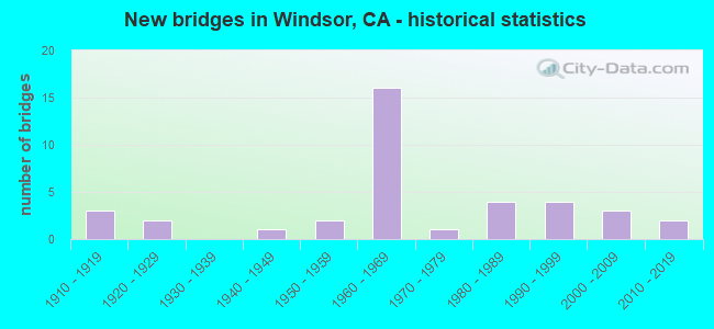
- New bridges - historical statistics
- 31910-1919
- 21920-1929
- 11940-1949
- 21950-1959
- 161960-1969
- 11970-1979
- 41980-1989
- 41990-1999
- 32000-2009
- 22010-2019
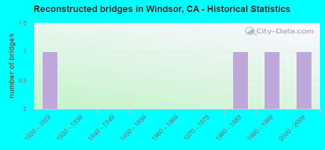
- Reconstructed bridges - Historical Statistics
- 11920-1929
- 01930-1939
- 01940-1949
- 01950-1959
- 01960-1969
- 01970-1979
- 11980-1989
- 11990-1999
- 12000-2009
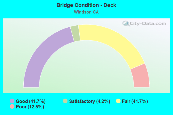
- Bridge Condition - Deck
- 41.7%Good
- 4.2%Satisfactory
- 41.7%Fair
- 12.5%Poor
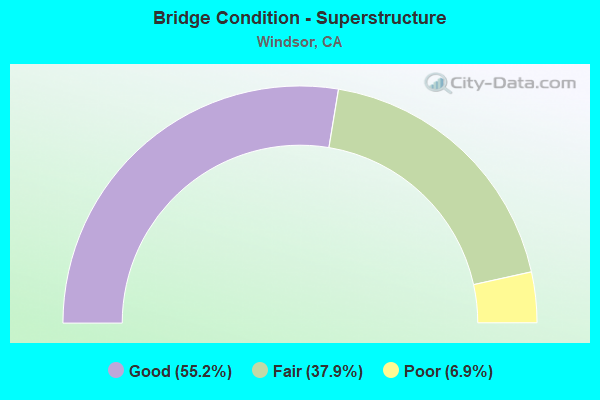
- Bridge Condition - Superstructure
- 55.2%Good
- 37.9%Fair
- 6.9%Poor
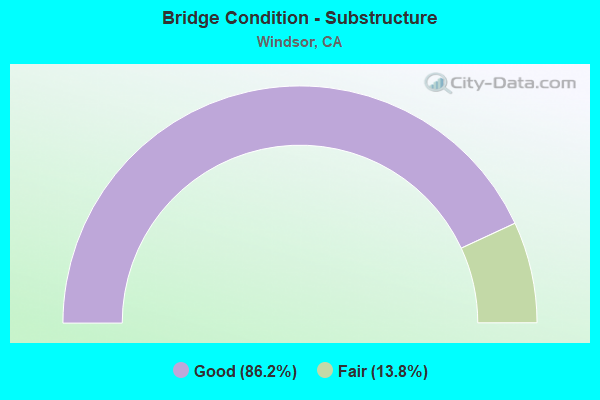
- Bridge Condition - Substructure
- 86.2%Good
- 13.8%Fair
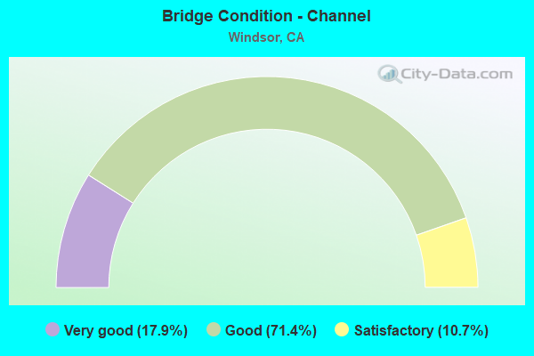
- Bridge Condition - Channel
- 17.9%Very good
- 71.4%Good
- 10.7%Satisfactory
Find on map >> Show street view
Structure Number: 20 0061L, Location: 04-SON-101-30.67 (Lat: 38.561656, Lng: -122.822958), Route carried "on" structure: US 101, Year Built: 1962, Status: Open, Structure Length: 4.27m (14.01ft), Average Daily Traffic: 22,500 (year 2013), Truck Traffic: 15%, Average Future Daily Traffic: 41,886 (year 2038), Design Load: HS 20, Features Intersected: ARATA LANE
Minimum Vertical Clearance: 30+ m (98+ ft), Kilometerpoint: 30.670, Lanes on structure: 2, Lanes under structure: 2, Base Highway Network: Yes (Inventory Route: 1, Subroute: 1), Owner: State Highway Agency, Approaching Roadway Width: 11.3m (37.1ft), Skew: 3 degrees, Material/Design: Concrete continuous, Design/Construction: Tee Beam, Number Of Spans In Main Unit: 3, Length of Maximum Span: 20.1m (65.9ft), Curb-To-Curb Width: 11.3m (37.1ft), Out-to-Out Width: 12.1m (39.7ft)
Condition: Deck: Fair, Superstructure: Good, Substructure: Good, Operating Rating: 28.2 metric tons, Method Used To Determine Operating Rating: Load and Resistance Factor Rating (LRFR) rating reported by rating factor(RF) method using HL-93 loadings, Inventory Rating: 21.7 metric tons, Method Used To Determine Inventory Rating: Load and Resistance Factor Rating (LRFR) rating reported by rating factor(RF) method using HL-93 loadings, Structural Evaluation: Somewhat better than minimum adequacy, Deck Geometry: Somewhat better than minimum adequacy, Underclear: Better than present minimum criteria, Approach Roadway Alignment: Equal to present desirable criteria, Length Of Structure Improvement: 4.27m (14.01ft), Designated Inspection Frequency: Every 24 months, Inspection Date: April 2021, Deck Structure Type: Concrete Cast-file-Place
Find on map >> Show street view
Structure Number: 20 0061R, Location: 04-SON-101-30.67 (Lat: 38.561653, Lng: -122.822642), Route carried "on" structure: US 101, Year Built: 1962, Status: Open, Structure Length: 4.27m (14.01ft), Average Daily Traffic: 22,750 (year 2017), Truck Traffic: 15%, Average Future Daily Traffic: 50,753 (year 2038), Design Load: HS 20, Features Intersected: ARATA LANE
Minimum Vertical Clearance: 30+ m (98+ ft), Kilometerpoint: 30.670, Lanes on structure: 2, Lanes under structure: 2, Base Highway Network: Yes (Inventory Route: 1, Subroute: 1), Owner: State Highway Agency, Approaching Roadway Width: 11.3m (37.1ft), Skew: 3 degrees, Material/Design: Concrete continuous, Design/Construction: Tee Beam, Number Of Spans In Main Unit: 3, Length of Maximum Span: 20.1m (65.9ft), Curb-To-Curb Width: 11.3m (37.1ft), Out-to-Out Width: 12.1m (39.7ft)
Condition: Deck: Fair, Superstructure: Good, Substructure: Good, Operating Rating: 28.2 metric tons, Method Used To Determine Operating Rating: Load and Resistance Factor Rating (LRFR) rating reported by rating factor(RF) method using HL-93 loadings, Inventory Rating: 21.7 metric tons, Method Used To Determine Inventory Rating: Load and Resistance Factor Rating (LRFR) rating reported by rating factor(RF) method using HL-93 loadings, Structural Evaluation: Somewhat better than minimum adequacy, Deck Geometry: Somewhat better than minimum adequacy, Underclear: Meets minimum limits, Approach Roadway Alignment: Equal to present desirable criteria, Length Of Structure Improvement: 4.27m (14.01ft), Designated Inspection Frequency: Every 24 months, Inspection Date: April 2021, Deck Structure Type: Concrete Cast-file-Place
Find on map >> Show street view
Structure Number: 20 0182, Location: 04-SON-101-27.97 (Lat: 38.530072, Lng: -122.793764), Route carried "on" structure: US 101, Year Built: 1962, Year Reconstructed: 2009, Status: Open, Structure Length: 2.04m (6.69ft), Average Daily Traffic: 62,000 (year 2014), Truck Traffic: 6%, Average Future Daily Traffic: 142,000 (year 2037), Design Load: HS 20, Features Intersected: POOL CREEK
Minimum Vertical Clearance: 30+ m (98+ ft), Kilometerpoint: 27.970, Lanes on structure: 6, Base Highway Network: Yes (Inventory Route: 1, Subroute: 1), Owner: State Highway Agency, Approaching Roadway Width: 34.2m (112.2ft), Skew: 32 degrees, Material/Design: Concrete continuous, Design/Construction: Slab, Number Of Spans In Main Unit: 3, Length of Maximum Span: 7.9m (25.9ft), Curb-To-Curb Width: 34.0m (111.5ft), Out-to-Out Width: 35.2m (115.5ft)
Condition: Deck: Fair, Superstructure: Fair, Substructure: Good, Channel: Good, Operating Rating: 68.7 metric tons, Method Used To Determine Operating Rating: Load Factor (LF), Inventory Rating: 40.2 metric tons, Method Used To Determine Inventory Rating: Load Factor (LF), Structural Evaluation: Somewhat better than minimum adequacy, Deck Geometry: Superior to present desirable criteria, Waterway Adequacy: Equal to present desirable criteria, Approach Roadway Alignment: Superior to present desirable criteria, Designated Inspection Frequency: Every 24 months, Inspection Date: August 2020, Deck Structure Type: Concrete Cast-file-Place
Find on map >> Show street view
Structure Number: 20 0184L, Location: 04-SON-101-29.35 (Lat: 38.546656, Lng: -122.807989), Route carried "on" structure: US 101, Year Built: 1962, Status: Open, Structure Length: 9.57m (31.40ft), Average Daily Traffic: 22,500 (year 2013), Truck Traffic: 15%, Average Future Daily Traffic: 41,886 (year 2038), Design Load: HS 20, Features Intersected: WINDSOR LANE
Minimum Vertical Clearance: 30+ m (98+ ft), Kilometerpoint: 29.350, Lanes on structure: 2, Lanes under structure: 6, Base Highway Network: Yes (Inventory Route: 1, Subroute: 1), Owner: State Highway Agency, Approaching Roadway Width: 11.3m (37.1ft), Skew: 5 degrees, Material/Design: Concrete continuous, Design/Construction: Box Beam or Girders - Multiple, Number Of Spans In Main Unit: 4, Length of Maximum Span: 26.2m (86.0ft), Curb-To-Curb Width: 11.3m (37.1ft), Out-to-Out Width: 12.1m (39.7ft)
Condition: Deck: Fair, Superstructure: Fair, Substructure: Good, Operating Rating: 53.1 metric tons, Method Used To Determine Operating Rating: Load and Resistance Factor Rating (LRFR) rating reported by rating factor(RF) method using HL-93 loadings, Inventory Rating: 37.9 metric tons, Method Used To Determine Inventory Rating: Load and Resistance Factor Rating (LRFR) rating reported by rating factor(RF) method using HL-93 loadings, Structural Evaluation: Somewhat better than minimum adequacy, Deck Geometry: Somewhat better than minimum adequacy, Underclear: Somewhat better than minimum adequacy, Approach Roadway Alignment: Equal to present desirable criteria, Length Of Structure Improvement: 9.57m (31.40ft), Designated Inspection Frequency: Every 24 months, Inspection Date: April 2021, Deck Structure Type: Concrete Cast-file-Place
Find on map >> Show street view
Structure Number: 20 0184R, Location: 04-SON-101-29.35 (Lat: 38.546478, Lng: -122.807572), Route carried "on" structure: US 101, Year Built: 1962, Status: Open, Structure Length: 9.27m (30.41ft), Average Daily Traffic: 22,750 (year 2015), Truck Traffic: 15%, Average Future Daily Traffic: 50,753 (year 2039), Design Load: HS 20, Features Intersected: WINDSOR LANE
Minimum Vertical Clearance: 30+ m (98+ ft), Kilometerpoint: 29.350, Lanes on structure: 2, Lanes under structure: 6, Base Highway Network: Yes (Inventory Route: 1, Subroute: 1), Owner: State Highway Agency, Approaching Roadway Width: 11.3m (37.1ft), Skew: 5 degrees, Material/Design: Concrete continuous, Design/Construction: Box Beam or Girders - Multiple, Number Of Spans In Main Unit: 4, Length of Maximum Span: 25.6m (84.0ft), Curb-To-Curb Width: 11.3m (37.1ft), Out-to-Out Width: 12.1m (39.7ft)
Condition: Deck: Fair, Superstructure: Good, Substructure: Good, Operating Rating: 55.7 metric tons, Method Used To Determine Operating Rating: Load and Resistance Factor Rating (LRFR) rating reported by rating factor(RF) method using HL-93 loadings, Inventory Rating: 39.9 metric tons, Method Used To Determine Inventory Rating: Load and Resistance Factor Rating (LRFR) rating reported by rating factor(RF) method using HL-93 loadings, Structural Evaluation: Better than present minimum criteria, Deck Geometry: Somewhat better than minimum adequacy, Underclear: Somewhat better than minimum adequacy, Approach Roadway Alignment: Equal to present desirable criteria, Designated Inspection Frequency: Every 24 months, Inspection Date: April 2021, Deck Structure Type: Concrete Cast-file-Place
Find on map >> Show street view
Structure Number: 20 0185, Location: 04-SON-101-29.50 (Lat: 38.549147, Lng: -122.809781), Route carried "on" structure: US 101, Year Built: 1962, Year Reconstructed: 1997, Status: Open, Structure Length: 1.07m (3.51ft), Average Daily Traffic: 45,500 (year 2015), Truck Traffic: 15%, Average Future Daily Traffic: 101,507 (year 2038), Features Intersected: WINDSOR CREEK
Minimum Vertical Clearance: 30+ m (98+ ft), Kilometerpoint: 29.500, Lanes on structure: 9, Base Highway Network: Yes (Inventory Route: 1, Subroute: 1), Owner: State Highway Agency, Approaching Roadway Width: 68.0m (223.1ft), Skew: 4 degrees, Material/Design: Concrete continuous, Design/Construction: Culvert, Number Of Spans In Main Unit: 1, Length of Maximum Span: 9.1m (29.9ft)
Condition: Channel: Very good, Culverts: Satisfactory, Operating Rating: 54.1 metric tons, Method Used To Determine Operating Rating: Field evaluation and documented engineering judgment, Inventory Rating: 32.4 metric tons, Method Used To Determine Inventory Rating: Field evaluation and documented engineering judgment, Structural Evaluation: Equal to present minimum criteria, Waterway Adequacy: Better than present minimum criteria, Approach Roadway Alignment: Equal to present desirable criteria, Designated Inspection Frequency: Every 24 months, Inspection Date: April 2021
Find on map >> Show street view
Structure Number: 20C0007, Location: 0.2 MI N OF RIVER RD (Lat: 38.485289, Lng: -122.825553), Route carried "on" structure: County highway , Year Built: 1986, Status: Open, Structure Length: 4.13m (13.55ft), Average Daily Traffic: 3,242 (year 2011), Truck Traffic: 1%, Average Future Daily Traffic: 1,732 (year 2044), Design Load: HS 20+Mod, Features Intersected: MARK WEST CREEK, Facility Carried by Structure: SLUSSER RD
Minimum Vertical Clearance: 30+ m (98+ ft), Kilometerpoint: 0.000, Lanes on structure: 2, Owner: County Highway Agency, Approaching Roadway Width: 7.3m (24.0ft), Skew: 1 degrees, Material/Design: Concrete continuous, Design/Construction: Box Beam or Girders - Multiple, Number Of Spans In Main Unit: 2, Length of Maximum Span: 20.3m (66.6ft), Curb-To-Curb Width: 9.8m (32.2ft), Out-to-Out Width: 10.8m (35.4ft)
Condition: Deck: Satisfactory, Superstructure: Fair, Substructure: Good, Channel: Satisfactory, Operating Rating: 48.6 metric tons, Method Used To Determine Operating Rating: Load and Resistance Factor Rating (LRFR) rating reported by rating factor(RF) method using HL-93 loadings, Inventory Rating: 37.6 metric tons, Method Used To Determine Inventory Rating: Load and Resistance Factor Rating (LRFR) rating reported by rating factor(RF) method using HL-93 loadings, Structural Evaluation: Somewhat better than minimum adequacy, Deck Geometry: Meets minimum limits, Waterway Adequacy: Equal to present desirable criteria, Approach Roadway Alignment: Better than present minimum criteria, Designated Inspection Frequency: Every 24 months, Inspection Date: March 2022, Deck Structure Type: Concrete Cast-file-Place
Find on map >> Show street view
Structure Number: 20C0053, Location: 0.4 MI N SHILO RD (Lat: 38.530122, Lng: -122.793486), Route carried "on" structure: County highway , Year Built: 1962, Year Reconstructed: 1994, Status: Open, Structure Length: 2.04m (6.69ft), Average Daily Traffic: 8,100 (year 2011), Truck Traffic: 2%, Average Future Daily Traffic: 11,591 (year 2041), Design Load: HS 20, Features Intersected: POOL CREEK, Facility Carried by Structure: HEMBREE LANE
Minimum Vertical Clearance: 30+ m (98+ ft), Kilometerpoint: 0.000, Lanes on structure: 2, Owner: Town or Township Highway Agency, Approaching Roadway Width: 12.5m (41.0ft), Skew: 2 degrees, Material/Design: Concrete continuous, Design/Construction: Slab, Number Of Spans In Main Unit: 3, Length of Maximum Span: 7.9m (25.9ft), Curb or Sidewalk Widths: Left: 0.6m (2.0ft), Right: 1.5m (4.9ft), Curb-To-Curb Width: 12.5m (41.0ft), Out-to-Out Width: 15.2m (49.9ft)
Condition: Deck: Fair, Superstructure: Fair, Substructure: Good, Channel: Good, Operating Rating: 57.1 metric tons, Method Used To Determine Operating Rating: Load Factor (LF), Inventory Rating: 33.5 metric tons, Method Used To Determine Inventory Rating: Load Factor (LF), Structural Evaluation: Somewhat better than minimum adequacy, Deck Geometry: Somewhat better than minimum adequacy, Waterway Adequacy: Better than present minimum criteria, Approach Roadway Alignment: Equal to present desirable criteria, Designated Inspection Frequency: Every 24 months, Inspection Date: May 2021, Deck Structure Type: Concrete Cast-file-Place
Find on map >> Show street view
Structure Number: 20C0064, Location: 4.8 MI WEST OF US 101 (Lat: 38.484553, Lng: -122.842622), Route carried "on" structure: County highway , Year Built: 1960, Status: Open, Structure Length: 15.18m (49.80ft), Average Daily Traffic: 11,700 (year 2015), Truck Traffic: 3%, Average Future Daily Traffic: 12,242 (year 2040), Design Load: HS 20, Features Intersected: MARK WEST CR, TRENTON RD, Facility Carried by Structure: RIVER RD
Minimum Vertical Clearance: 30+ m (98+ ft), Kilometerpoint: 0.000, Lanes on structure: 2, Lanes under structure: 2, Owner: County Highway Agency, Approaching Roadway Width: 9.8m (32.2ft), Material/Design: Concrete continuous, Design/Construction: Tee Beam, Number Of Spans In Main Unit: 10, Length of Maximum Span: 15.8m (51.8ft), Curb-To-Curb Width: 9.8m (32.2ft), Out-to-Out Width: 9.9m (32.5ft)
Condition: Deck: Fair, Superstructure: Good, Substructure: Good, Channel: Very good, Operating Rating: 47.3 metric tons, Method Used To Determine Operating Rating: Load Factor (LF), Inventory Rating: 28.5 metric tons, Method Used To Determine Inventory Rating: Load Factor (LF), Structural Evaluation: Better than present minimum criteria, Deck Geometry: Meets minimum limits, Underclear: Equal to present minimum criteria, Waterway Adequacy: Equal to present desirable criteria, Approach Roadway Alignment: Equal to present desirable criteria, Designated Inspection Frequency: Every 24 months, Inspection Date: October 2020, Deck Structure Type: Concrete Cast-file-Place
Find on map >> Show street view
Structure Number: 20C008, Location: 35.7 MI N MARIN CO LINE (Lat: 38.618403, Lng: -122.879164), Route carried "on" structure: County highway , Year Built: 1960, Status: Open, Structure Length: 1.13m (3.71ft), Average Daily Traffic: 1,000 (year 2015), Truck Traffic: 1%, Average Future Daily Traffic: 2,116 (year 2038), Features Intersected: WEST NORTON SLOUGH, Facility Carried by Structure: KINLEY DR
Minimum Vertical Clearance: 30+ m (98+ ft), Kilometerpoint: 0.000, Lanes on structure: 2, Owner: County Highway Agency, Approaching Roadway Width: 7.9m (25.9ft), Skew: 3 degrees, Material/Design: Concrete continuous, Design/Construction: Culvert, Number Of Spans In Main Unit: 2, Length of Maximum Span: 5.5m (18.0ft), Curb-To-Curb Width: 9.8m (32.2ft), Out-to-Out Width: 10.5m (34.4ft)
Condition: Channel: Good, Culverts: Satisfactory, Operating Rating: 54.1 metric tons, Method Used To Determine Operating Rating: Field evaluation and documented engineering judgment, Inventory Rating: 32.4 metric tons, Method Used To Determine Inventory Rating: Field evaluation and documented engineering judgment, Structural Evaluation: Equal to present minimum criteria, Deck Geometry: Equal to present minimum criteria, Waterway Adequacy: Better than present minimum criteria, Approach Roadway Alignment: Equal to present desirable criteria, Designated Inspection Frequency: Every 48 months, Inspection Date: October 2018, Deck Structure Type: Concrete Cast-file-Place, Wearing Surface/Protective System: Wearing Surface: Bituminous
Find on map >> Show street view
Structure Number: 20C0086, Location: 0.5 MI S/O PLEASANT RD (Lat: 38.534208, Lng: -122.786775), Route carried "on" structure: County highway , Year Built: 1925, Status: Open, Structure Length: 0.94m (3.08ft), Average Daily Traffic: 13,800 (year 2015), Truck Traffic: 2%, Average Future Daily Traffic: 8,495 (year 2038), Features Intersected: POOL CREEK, Facility Carried by Structure: OLD REDWOOD HWY
Minimum Vertical Clearance: 30+ m (98+ ft), Kilometerpoint: 0.000, Lanes on structure: 2, Owner: Town or Township Highway Agency, Approaching Roadway Width: 10.4m (34.1ft), Material/Design: Steel, Design/Construction: Stringer/Multi-beam, Number Of Spans In Main Unit: 1, Length of Maximum Span: 8.5m (27.9ft), Curb-To-Curb Width: 8.5m (27.9ft), Out-to-Out Width: 9.5m (31.2ft)
Condition: Deck: Good, Superstructure: Fair, Substructure: Fair, Channel: Good, Operating Rating: 36.9 metric tons, Method Used To Determine Operating Rating: Load Factor (LF), Inventory Rating: 22.0 metric tons, Method Used To Determine Inventory Rating: Load Factor (LF), Structural Evaluation: Somewhat better than minimum adequacy, Deck Geometry: High priority of replacement, Waterway Adequacy: Better than present minimum criteria, Approach Roadway Alignment: Equal to present desirable criteria, Designated Inspection Frequency: Every 24 months, Inspection Date: May 2021, Deck Structure Type: Concrete Cast-file-Place, Wearing Surface/Protective System: Wearing Surface: Bituminous
Find on map >> Show street view
Structure Number: 20C0089, Location: 0.7 MI SE EASTSIDE RD (Lat: 38.567147, Lng: -122.832353), Route carried "on" structure: County highway , Year Built: 1913, Year Reconstructed: 1925, Status: Open, Structure Length: 0.70m (2.30ft), Average Daily Traffic: 5,900 (year 2009), Truck Traffic: 6%, Average Future Daily Traffic: 6,000 (year 2038), Features Intersected: SOTOYOME CREEK, Facility Carried by Structure: OLD REDWOOD HWY
Minimum Vertical Clearance: 30+ m (98+ ft), Kilometerpoint: 0.000, Lanes on structure: 2, Owner: County Highway Agency, Approaching Roadway Width: 10.7m (35.1ft), Skew: 4 degrees, Material/Design: Concrete, Design/Construction: Tee Beam, Number Of Spans In Main Unit: 1, Length of Maximum Span: 6.4m (21.0ft), Curb-To-Curb Width: 9.8m (32.2ft), Out-to-Out Width: 10.8m (35.4ft)
Condition: Deck: Good, Superstructure: Fair, Substructure: Good, Channel: Good, Operating Rating: 28.2 metric tons, Method Used To Determine Operating Rating: Field evaluation and documented engineering judgment, Inventory Rating: 16.8 metric tons, Method Used To Determine Inventory Rating: Field evaluation and documented engineering judgment, Structural Evaluation: Meets minimum limits, Deck Geometry: Meets minimum limits, Waterway Adequacy: Better than present minimum criteria, Approach Roadway Alignment: Equal to present minimum criteria, Designated Inspection Frequency: Every 24 months, Inspection Date: May 2021, Deck Structure Type: Concrete Cast-file-Place, Wearing Surface/Protective System: Wearing Surface: Bituminous
Find on map >> Show street view
Structure Number: 20C0157, Location: 11.2 MI W OF SR 116 (Lat: 38.482644, Lng: -122.830986), Route carried "on" structure: County highway , Year Built: 1958, Status: Open, Structure Length: 7.13m (23.39ft), Average Daily Traffic: 8,000 (year 2018), Truck Traffic: 2%, Average Future Daily Traffic: 10,700 (year 2041), Design Load: HS 20, Features Intersected: MARK WEST CREEK, Facility Carried by Structure: RIVER RD
Minimum Vertical Clearance: 30+ m (98+ ft), Kilometerpoint: 0.000, Lanes on structure: 2, Owner: County Highway Agency, Approaching Roadway Width: 9.1m (29.9ft), Skew: 6 degrees, Material/Design: Concrete continuous, Design/Construction: Tee Beam, Number Of Spans In Main Unit: 3, Length of Maximum Span: 25.6m (84.0ft), Curb-To-Curb Width: 9.8m (32.2ft), Out-to-Out Width: 9.9m (32.5ft)
Condition: Deck: Poor, Superstructure: Good, Substructure: Good, Channel: Good, Operating Rating: 27.9 metric tons, Method Used To Determine Operating Rating: Load and Resistance Factor Rating (LRFR) rating reported by rating factor(RF) method using HL-93 loadings, Inventory Rating: 21.4 metric tons, Method Used To Determine Inventory Rating: Load and Resistance Factor Rating (LRFR) rating reported by rating factor(RF) method using HL-93 loadings, Structural Evaluation: Somewhat better than minimum adequacy, Deck Geometry: Meets minimum limits, Waterway Adequacy: Equal to present minimum criteria, Approach Roadway Alignment: Equal to present minimum criteria, Length Of Structure Improvement: 7.13m (23.39ft), Designated Inspection Frequency: Every 24 months, Inspection Date: Febuary 2021, Bridge Improvement Cost: $709,000, Roadway Improvement Cost: $141,000, Total Project Cost: $1,191,000 ( Estimate for 2017), Deck Structure Type: Concrete Cast-file-Place
Find on map >> Show street view
Structure Number: 20C0239, Location: 0.3 MI N OF RIVER RD (Lat: 38.493839, Lng: -122.852858), Route carried "on" structure: County highway , Year Built: 1988, Status: Open, Structure Length: 5.49m (18.01ft), Average Daily Traffic: 1,700 (year 2018), Truck Traffic: 2%, Average Future Daily Traffic: 2,081 (year 2041), Design Load: HS 20+Mod, Features Intersected: MARK WEST CREEK, Facility Carried by Structure: TRENTON HEALDSBRG
Minimum Vertical Clearance: 30+ m (98+ ft), Kilometerpoint: 0.000, Lanes on structure: 2, Owner: County Highway Agency, Approaching Roadway Width: 9.8m (32.2ft), Material/Design: Concrete continuous, Design/Construction: Slab, Number Of Spans In Main Unit: 4, Length of Maximum Span: 15.2m (49.9ft), Curb-To-Curb Width: 9.8m (32.2ft), Out-to-Out Width: 10.0m (32.8ft)
Condition: Deck: Poor, Superstructure: Poor, Substructure: Good, Channel: Very good, Operating Rating: 54.1 metric tons, Method Used To Determine Operating Rating: Assigned rating based on Load Factor Design (LFD) reported in metric tons, Inventory Rating: 32.4 metric tons, Method Used To Determine Inventory Rating: Assigned rating based on Load Factor Design (LFD) reported in metric tons, Structural Evaluation: Meets minimum limits, Deck Geometry: Somewhat better than minimum adequacy, Waterway Adequacy: Better than present minimum criteria, Approach Roadway Alignment: Somewhat better than minimum adequacy, Length Of Structure Improvement: 5.49m (18.01ft), Designated Inspection Frequency: Every 24 months, Inspection Date: Febuary 2021, Bridge Improvement Cost: $547,000, Roadway Improvement Cost: $109,000, Total Project Cost: $918,000 ( Estimate for 2017), Deck Structure Type: Concrete Cast-file-Place
Find on map >> Show street view
Structure Number: 20C0241, Location: 0.8 MI E OF OLD REDWOOD H (Lat: 38.540317, Lng: -122.780092), Route carried "on" structure: County highway , Year Built: 1925, Status: Open, Structure Length: 0.94m (3.08ft), Average Daily Traffic: 2,000 (year 2015), Truck Traffic: 3%, Average Future Daily Traffic: 2,453 (year 2040), Features Intersected: POOL CREEK, Facility Carried by Structure: PLEASANT AVE
Minimum Vertical Clearance: 30+ m (98+ ft), Kilometerpoint: 0.000, Lanes on structure: 2, Owner: County Highway Agency, Approaching Roadway Width: 6.1m (20.0ft), Skew: 3 degrees, Material/Design: Concrete, Design/Construction: Tee Beam, Number Of Spans In Main Unit: 1, Length of Maximum Span: 9.1m (29.9ft), Curb-To-Curb Width: 6.1m (20.0ft), Out-to-Out Width: 7.2m (23.6ft)
Condition: Deck: Good, Superstructure: Fair, Substructure: Good, Channel: Satisfactory, Operating Rating: 45.4 metric tons, Method Used To Determine Operating Rating: Load and Resistance Factor Rating (LRFR) rating reported by rating factor(RF) method using HL-93 loadings, Inventory Rating: 35.0 metric tons, Method Used To Determine Inventory Rating: Load and Resistance Factor Rating (LRFR) rating reported by rating factor(RF) method using HL-93 loadings, Structural Evaluation: Somewhat better than minimum adequacy, Deck Geometry: High priority of replacement, Waterway Adequacy: Better than present minimum criteria, Approach Roadway Alignment: Equal to present desirable criteria, Designated Inspection Frequency: Every 24 months, Inspection Date: October 2020, Deck Structure Type: Concrete Cast-file-Place, Wearing Surface/Protective System: Wearing Surface: Bituminous
Find on map >> Show street view
Structure Number: 20C0242, Location: 1 MI S OF SR 128 (Lat: 38.621897, Lng: -122.773589), Route carried "on" structure: County highway , Year Built: 1915, Status: Open, Structure Length: 5.18m (16.99ft), Average Daily Traffic: 800 (year 2015), Truck Traffic: 1%, Average Future Daily Traffic: 419 (year 2040), Features Intersected: MAACAMA CREEK, Facility Carried by Structure: CHALK HILL RD
Minimum Vertical Clearance: 30+ m (98+ ft), Kilometerpoint: 0.000, Lanes on structure: 1, Owner: County Highway Agency, Approaching Roadway Width: 4.9m (16.1ft), Material/Design: Concrete, Design/Construction: Arch - Deck, Number Of Spans In Main Unit: 1, Number Of Approach Spans: 4, Length of Maximum Span: 33.5m (109.9ft), Curb-To-Curb Width: 4.9m (16.1ft), Out-to-Out Width: 5.5m (18.0ft)
Condition: Deck: Good, Superstructure: Fair, Substructure: Good, Channel: Good, Operating Rating: 29.2 metric tons, Method Used To Determine Operating Rating: Field evaluation and documented engineering judgment, Inventory Rating: 17.5 metric tons, Method Used To Determine Inventory Rating: Field evaluation and documented engineering judgment, Structural Evaluation: Meets minimum limits, Deck Geometry: High priority of replacement, Waterway Adequacy: Equal to present desirable criteria, Approach Roadway Alignment: Equal to present minimum criteria, Designated Inspection Frequency: Every 24 months, Inspection Date: July 2021, Deck Structure Type: Concrete Cast-file-Place, Wearing Surface/Protective System: Wearing Surface: Bituminous
Find on map >> Show street view
Structure Number: 20C0247, Location: 1.2 MI E OF TRE-HEALDS RD (Lat: 38.510892, Lng: -122.840031), Route carried "on" structure: County highway , Year Built: 1976, Status: Open, Structure Length: 1.16m (3.81ft), Average Daily Traffic: 400 (year 2015), Truck Traffic: 5%, Average Future Daily Traffic: 557 (year 2040), Design Load: HS 20, Features Intersected: WINDSOR CREEK, Facility Carried by Structure: MARK WEST STA RD
Minimum Vertical Clearance: 30+ m (98+ ft), Kilometerpoint: 0.000, Lanes on structure: 2, Owner: County Highway Agency, Approaching Roadway Width: 6.1m (20.0ft), Material/Design: Concrete, Design/Construction: Slab, Number Of Spans In Main Unit: 1, Length of Maximum Span: 11.0m (36.1ft), Curb-To-Curb Width: 6.6m (21.7ft), Out-to-Out Width: 6.8m (22.3ft)
Condition: Deck: Good, Superstructure: Good, Substructure: Good, Channel: Good, Operating Rating: 51.8 metric tons, Method Used To Determine Operating Rating: Load Factor (LF), Inventory Rating: 31.1 metric tons, Method Used To Determine Inventory Rating: Load Factor (LF), Structural Evaluation: Better than present minimum criteria, Deck Geometry: Meets minimum limits, Waterway Adequacy: Meets minimum limits, Approach Roadway Alignment: Equal to present desirable criteria, Designated Inspection Frequency: Every 24 months, Inspection Date: June 2021, Deck Structure Type: Concrete Cast-file-Place
Find on map >> Show street view
Structure Number: 20C0329, Location: 3 MI SOUTH SR 128 (Lat: 38.610383, Lng: -122.772728), Route carried "on" structure: County highway , Year Built: 1965, Status: Open, Structure Length: 4.75m (15.58ft), Average Daily Traffic: 850 (year 2015), Truck Traffic: 2%, Average Future Daily Traffic: 1,000 (year 2040), Design Load: HS 20, Features Intersected: FRANZ CREEK, Facility Carried by Structure: CHALK HILL RD
Minimum Vertical Clearance: 30+ m (98+ ft), Kilometerpoint: 0.000, Lanes on structure: 2, Owner: County Highway Agency, Approaching Roadway Width: 9.8m (32.2ft), Skew: 1 degrees, Material/Design: Concrete continuous, Design/Construction: Slab, Number Of Spans In Main Unit: 4, Length of Maximum Span: 13.4m (44.0ft), Curb-To-Curb Width: 9.8m (32.2ft), Out-to-Out Width: 10.0m (32.8ft)
Condition: Deck: Good, Superstructure: Good, Substructure: Good, Channel: Good, Operating Rating: 71.0 metric tons, Method Used To Determine Operating Rating: Load Factor (LF), Inventory Rating: 42.4 metric tons, Method Used To Determine Inventory Rating: Load Factor (LF), Structural Evaluation: Better than present minimum criteria, Deck Geometry: Equal to present minimum criteria, Waterway Adequacy: Equal to present desirable criteria, Approach Roadway Alignment: Equal to present desirable criteria, Designated Inspection Frequency: Every 48 months, Inspection Date: July 2021, Deck Structure Type: Concrete Cast-file-Place
Find on map >> Show street view
Structure Number: 20C033, Location: 4.5 MI S OF SR 128 (Lat: 38.600269, Lng: -122.777617), Route carried "on" structure: County highway , Year Built: 1956, Status: Open, Structure Length: 1.62m (5.31ft), Average Daily Traffic: 850 (year 2015), Truck Traffic: 1%, Average Future Daily Traffic: 1,000 (year 2040), Features Intersected: BROOKS CREEK, Facility Carried by Structure: CHALK HILL RD
Minimum Vertical Clearance: 30+ m (98+ ft), Kilometerpoint: 0.000, Lanes on structure: 2, Owner: County Highway Agency, Approaching Roadway Width: 6.7m (22.0ft), Material/Design: Concrete, Design/Construction: Slab, Number Of Spans In Main Unit: 2, Length of Maximum Span: 7.9m (25.9ft), Curb-To-Curb Width: 8.5m (27.9ft), Out-to-Out Width: 8.7m (28.5ft)
Condition: Deck: Good, Superstructure: Good, Substructure: Fair, Channel: Good, Operating Rating: 36.6 metric tons, Method Used To Determine Operating Rating: Load Factor (LF), Inventory Rating: 22.0 metric tons, Method Used To Determine Inventory Rating: Load Factor (LF), Structural Evaluation: Somewhat better than minimum adequacy, Deck Geometry: Somewhat better than minimum adequacy, Waterway Adequacy: Equal to present desirable criteria, Approach Roadway Alignment: Equal to present desirable criteria, Designated Inspection Frequency: Every 24 months, Inspection Date: July 2021, Deck Structure Type: Concrete Cast-file-Place
Find on map >> Show street view
Structure Number: 20C0337, Location: 0.2 MI N OF SHILOH RD (Lat: 38.526933, Lng: -122.816719), Route carried "on" structure: County highway , Year Built: 1967, Status: Open, Structure Length: 2.65m (8.69ft), Average Daily Traffic: 5,900 (year 2011), Truck Traffic: 2%, Average Future Daily Traffic: 7,880 (year 2038), Design Load: HS 20, Features Intersected: POOL CREEK, Facility Carried by Structure: WINDSOR ROAD
Minimum Vertical Clearance: 30+ m (98+ ft), Kilometerpoint: 0.000, Lanes on structure: 2, Owner: Town or Township Highway Agency, Approaching Roadway Width: 11.6m (38.1ft), Skew: 4 degrees, Material/Design: Concrete continuous, Design/Construction: Slab, Number Of Spans In Main Unit: 3, Length of Maximum Span: 10.4m (34.1ft), Curb-To-Curb Width: 12.2m (40.0ft), Out-to-Out Width: 12.4m (40.7ft)
Condition: Deck: Poor, Superstructure: Poor, Substructure: Good, Channel: Good, Operating Rating: 61.9 metric tons, Method Used To Determine Operating Rating: Load Factor (LF), Inventory Rating: 37.3 metric tons, Method Used To Determine Inventory Rating: Load Factor (LF), Structural Evaluation: Meets minimum limits, Deck Geometry: Somewhat better than minimum adequacy, Waterway Adequacy: Better than present minimum criteria, Approach Roadway Alignment: Equal to present desirable criteria, Designated Inspection Frequency: Every 24 months, Inspection Date: May 2021, Deck Structure Type: Concrete Cast-file-Place
Find on map >> Show street view
Structure Number: 20C0342, Location: 0.3 MI N OF SILK RD (Lat: 38.517897, Lng: -122.821375), Route carried "on" structure: County highway , Year Built: 1946, Status: Open, Structure Length: 0.94m (3.08ft), Average Daily Traffic: 1,500 (year 2015), Truck Traffic: 4%, Average Future Daily Traffic: 1,918 (year 2040), Features Intersected: BRANCH WINDSOR CREEK, Facility Carried by Structure: WINDSOR RD
Minimum Vertical Clearance: 30+ m (98+ ft), Kilometerpoint: 0.000, Lanes on structure: 2, Owner: County Highway Agency, Approaching Roadway Width: 6.5m (21.3ft), Material/Design: Steel, Design/Construction: Stringer/Multi-beam, Number Of Spans In Main Unit: 1, Length of Maximum Span: 9.1m (29.9ft), Curb or Sidewalk Widths: Left: 0.2m (0.7ft), Right: 0.2m (0.7ft), Curb-To-Curb Width: 7.4m (24.3ft), Out-to-Out Width: 7.9m (25.9ft)
Condition: Deck: Fair, Superstructure: Fair, Substructure: Fair, Channel: Satisfactory, Operating Rating: 39.2 metric tons, Method Used To Determine Operating Rating: Load Factor (LF), Inventory Rating: 23.7 metric tons, Method Used To Determine Inventory Rating: Load Factor (LF), Structural Evaluation: Somewhat better than minimum adequacy, Deck Geometry: Meets minimum limits, Waterway Adequacy: Better than present minimum criteria, Approach Roadway Alignment: Equal to present desirable criteria, Designated Inspection Frequency: Every 24 months, Inspection Date: October 2020, Deck Structure Type: Concrete Cast-file-Place
Find on map >> Show street view
Structure Number: 20C0502, Location: 0.1 MI S.E. OF SH101 (Lat: 38.546353, Lng: -122.806356), Route carried "on" structure: County highway , Year Built: 1991, Status: Open, Structure Length: 0.79m (2.59ft), Average Daily Traffic: 20,000 (year 2015), Truck Traffic: 5%, Average Future Daily Traffic: 9,780 (year 2038), Features Intersected: EAST WINDSOR CREEK, Facility Carried by Structure: OLD REDWOOD HWY
Minimum Vertical Clearance: 30+ m (98+ ft), Kilometerpoint: 0.000, Lanes on structure: 3, Owner: Town or Township Highway Agency, Approaching Roadway Width: 8.5m (27.9ft), Material/Design: Concrete, Design/Construction: Arch - Deck, Number Of Spans In Main Unit: 1, Length of Maximum Span: 7.3m (24.0ft), Curb-To-Curb Width: 8.5m (27.9ft), Out-to-Out Width: 8.5m (27.9ft)
Condition: Superstructure: Good, Substructure: Good, Channel: Good, Operating Rating: 54.1 metric tons, Method Used To Determine Operating Rating: Field evaluation and documented engineering judgment, Inventory Rating: 32.4 metric tons, Method Used To Determine Inventory Rating: Field evaluation and documented engineering judgment, Structural Evaluation: Better than present minimum criteria, Deck Geometry: High priority of replacement, Waterway Adequacy: Equal to present desirable criteria, Approach Roadway Alignment: Better than present minimum criteria, Designated Inspection Frequency: Every 48 months, Inspection Date: July 2021
Find on map >> Show street view
Structure Number: 20C0506, Location: 320 FT EAST OF BELL AVE (Lat: 38.546517, Lng: -122.809989), Route carried "on" structure: County highway , Year Built: 1995, Status: Open, Structure Length: 0.79m (2.59ft), Average Daily Traffic: 5,400 (year 2013), Truck Traffic: 5%, Average Future Daily Traffic: 9,730 (year 2038), Features Intersected: WINDSOR CREEK, Facility Carried by Structure: CONDE LANE
Minimum Vertical Clearance: 30+ m (98+ ft), Kilometerpoint: 0.000, Lanes on structure: 2, Owner: Town or Township Highway Agency, Approaching Roadway Width: 15.8m (51.8ft), Material/Design: Concrete, Design/Construction: Arch - Deck, Number Of Spans In Main Unit: 1, Length of Maximum Span: 7.9m (25.9ft), Curb or Sidewalk Widths: Left: 2.4m (7.9ft), Right: 2.4m (7.9ft), Curb-To-Curb Width: 15.8m (51.8ft), Out-to-Out Width: 21.5m (70.5ft)
Condition: Superstructure: Fair, Substructure: Fair, Channel: Very good, Operating Rating: 54.1 metric tons, Method Used To Determine Operating Rating: Field evaluation and documented engineering judgment, Inventory Rating: 32.4 metric tons, Method Used To Determine Inventory Rating: Field evaluation and documented engineering judgment, Structural Evaluation: Somewhat better than minimum adequacy, Deck Geometry: Superior to present desirable criteria, Waterway Adequacy: Equal to present desirable criteria, Approach Roadway Alignment: Equal to present minimum criteria, Designated Inspection Frequency: Every 24 months, Inspection Date: July 2021
Find on map >> Show street view
Structure Number: 20C0507, Location: 100 YARDS WEST OF RTE 101 (Lat: 38.547269, Lng: -122.809875), Route carried "on" structure: City street , Year Built: 1995, Status: Open, Structure Length: 2.20m (7.22ft), Average Daily Traffic: 2,000 (year 2011), Truck Traffic: 5%, Average Future Daily Traffic: 6,413 (year 2038), Design Load: HS 20+Mod, Features Intersected: WINDSOR CREEK, Facility Carried by Structure: Old Redwood Hwy
Minimum Vertical Clearance: 30+ m (98+ ft), Kilometerpoint: 0.000, Lanes on structure: 5, Owner: Town or Township Highway Agency, Approaching Roadway Width: 19.0m (62.3ft), Skew: 30 degrees, Material/Design: Prestressed concrete, Design/Construction: Box Beam or Girders - Multiple, Number Of Spans In Main Unit: 1, Length of Maximum Span: 21.2m (69.6ft), Curb or Sidewalk Widths: Left: 2.3m (7.5ft), Right: 2.3m (7.5ft), Curb-To-Curb Width: 21.0m (68.9ft), Out-to-Out Width: 31.2m (102.4ft)
Condition: Deck: Fair, Superstructure: Good, Substructure: Good, Channel: Very good, Operating Rating: 54.1 metric tons, Method Used To Determine Operating Rating: Assigned rating based on Load Factor Design (LFD) reported in metric tons, Inventory Rating: 32.4 metric tons, Method Used To Determine Inventory Rating: Assigned rating based on Load Factor Design (LFD) reported in metric tons, Structural Evaluation: Better than present minimum criteria, Deck Geometry: Somewhat better than minimum adequacy, Waterway Adequacy: Equal to present desirable criteria, Approach Roadway Alignment: Equal to present desirable criteria, Designated Inspection Frequency: Every 24 months, Inspection Date: July 2021, Deck Structure Type: Concrete Cast-file-Place
Find on map >> Show street view
Structure Number: 20C054, Location: AT VINTAGE GREENS ROAD (Lat: 38.534314, Lng: -122.816617), Route carried "on" structure: Business City street , Year Built: 2005, Status: Open, Structure Length: 2.11m (6.92ft), Average Daily Traffic: 5,000 (year 2013), Truck Traffic: 3%, Average Future Daily Traffic: 7,310 (year 2038), Design Load: HS 20+Mod, Features Intersected: WINDSOR CREEK, Facility Carried by Structure: WINDSOR ROAD
Minimum Vertical Clearance: 30+ m (98+ ft), Kilometerpoint: 0.000, Lanes on structure: 3, Owner: Town or Township Highway Agency, Approaching Roadway Width: 13.8m (45.3ft), Skew: 2 degrees, Material/Design: Prestressed concrete, Design/Construction: Slab, Number Of Spans In Main Unit: 1, Length of Maximum Span: 21.1m (69.2ft), Curb or Sidewalk Widths: Left: 1.5m (4.9ft), Right: 1.8m (5.9ft), Curb-To-Curb Width: 13.8m (45.3ft), Out-to-Out Width: 17.5m (57.4ft)
Condition: Deck: Good, Superstructure: Good, Substructure: Good, Channel: Good, Operating Rating: 54.1 metric tons, Method Used To Determine Operating Rating: Assigned rating based on Load Factor Design (LFD) reported in metric tons, Inventory Rating: 32.4 metric tons, Method Used To Determine Inventory Rating: Assigned rating based on Load Factor Design (LFD) reported in metric tons, Structural Evaluation: Better than present minimum criteria, Deck Geometry: Somewhat better than minimum adequacy, Waterway Adequacy: Equal to present minimum criteria, Approach Roadway Alignment: Equal to present desirable criteria, Designated Inspection Frequency: Every 48 months, Inspection Date: July 2021, Deck Structure Type: Concrete Cast-file-Place, Wearing Surface/Protective System: Wearing Surface: Bituminous
Find on map >> Show street view
Structure Number: 20C057, Location: 1.45 MI E/O SR 1 (Lat: 38.435069, Lng: -123.086914), Route carried "on" structure: County highway , Year Built: 2011, Status: Open, Structure Length: 1.46m (4.79ft), Average Daily Traffic: 170 (year 2010), Truck Traffic: 1%, Average Future Daily Traffic: 210 (year 2040), Design Load: HL 93, Features Intersected: WILLOW CREEK, Facility Carried by Structure: WILLOW CREEK ROAD
Minimum Vertical Clearance: 30+ m (98+ ft), Kilometerpoint: 0.000, Lanes on structure: 2, Owner: County Highway Agency, Approaching Roadway Width: 7.4m (24.3ft), Material/Design: Prestressed concrete, Design/Construction: Slab, Number Of Spans In Main Unit: 1, Length of Maximum Span: 13.9m (45.6ft), Curb-To-Curb Width: 7.4m (24.3ft), Out-to-Out Width: 8.3m (27.2ft)
Condition: Deck: Good, Superstructure: Good, Substructure: Good, Channel: Good, Operating Rating: 42.1 metric tons, Method Used To Determine Operating Rating: Assigned ratings based on Load and Resistance Factor Design (LRFD) reported by rating factor (RF) using HL93 loadings, Inventory Rating: 32.4 metric tons, Method Used To Determine Inventory Rating: Assigned ratings based on Load and Resistance Factor Design (LRFD) reported by rating factor (RF) using HL93 loadings, Structural Evaluation: Better than present minimum criteria, Deck Geometry: Somewhat better than minimum adequacy, Waterway Adequacy: Equal to present desirable criteria, Approach Roadway Alignment: Equal to present desirable criteria, Designated Inspection Frequency: Every 48 months, Inspection Date: March 2022, Deck Structure Type: Concrete Precast Panels, Wearing Surface/Protective System: Wearing Surface: Bituminous
Find on map >> Show street view
Structure Number: 20C0575, Location: 0.1 MI EAST OF CONDE LANE (Lat: 38.525533, Lng: -122.795869), Route carried "on" structure: Business City street , Year Built: 2012, Status: Open, Structure Length: 1.90m (6.23ft), Average Daily Traffic: 20,000 (year 2013), Truck Traffic: 5%, Average Future Daily Traffic: 28,000 (year 2036), Design Load: HL 93, Features Intersected: PRUITT CREEK, Facility Carried by Structure: SHILOH ROAD
Minimum Vertical Clearance: 30+ m (98+ ft), Kilometerpoint: 0.000, Lanes on structure: 8, Owner: Town or Township Highway Agency, Approaching Roadway Width: 10.9m (35.8ft), Skew: 4 degrees, Material/Design: Concrete, Design/Construction: Arch - Deck, Number Of Spans In Main Unit: 2, Length of Maximum Span: 9.5m (31.2ft)
Condition: Superstructure: Good, Substructure: Good, Channel: Good, Operating Rating: 42.1 metric tons, Method Used To Determine Operating Rating: Assigned ratings based on Load and Resistance Factor Design (LRFD) reported by rating factor (RF) using HL93 loadings, Inventory Rating: 32.4 metric tons, Method Used To Determine Inventory Rating: Assigned ratings based on Load and Resistance Factor Design (LRFD) reported by rating factor (RF) using HL93 loadings, Structural Evaluation: Better than present minimum criteria, Waterway Adequacy: Better than present minimum criteria, Approach Roadway Alignment: Equal to present desirable criteria, Designated Inspection Frequency: Every 48 months, Inspection Date: July 2019
Find on map >> Show street view
Structure Number: 20C0576, Location: 200 FT S OF SHILOH ROAD (Lat: 38.525058, Lng: -122.792997), Route carried "on" structure: Business City street , Year Built: 1987, Status: Open, Structure Length: 2.07m (6.79ft), Average Daily Traffic: 10,000 (year 2013), Truck Traffic: 20%, Average Future Daily Traffic: 14,000 (year 2038), Features Intersected: PRUITT CREEK, Facility Carried by Structure: CALETTI AVE
Minimum Vertical Clearance: 30+ m (98+ ft), Kilometerpoint: 0.000, Lanes on structure: 2, Owner: Town or Township Highway Agency, Approaching Roadway Width: 16.3m (53.5ft), Skew: 3 degrees, Material/Design: Wood or Timber, Design/Construction: Stringer/Multi-beam, Number Of Spans In Main Unit: 1, Length of Maximum Span: 20.3m (66.6ft), Curb or Sidewalk Widths: Left: 0.0m, Right: 1.5m (4.9ft), Curb-To-Curb Width: 13.9m (45.6ft), Out-to-Out Width: 15.5m (50.9ft)
Condition: Deck: Good, Superstructure: Good, Substructure: Good, Channel: Good, Operating Rating: 30.5 metric tons, Method Used To Determine Operating Rating: Allowable Stress (AS), Inventory Rating: 17.5 metric tons, Method Used To Determine Inventory Rating: Allowable Stress (AS), Structural Evaluation: Meets minimum limits, Deck Geometry: Superior to present desirable criteria, Waterway Adequacy: Better than present minimum criteria, Approach Roadway Alignment: Equal to present desirable criteria, Designated Inspection Frequency: Every 24 months, Inspection Date: July 2021, Deck Structure Type: Wood or Timber, Wearing Surface/Protective System: Wearing Surface: Bituminous
Find on map >> Show street view
Structure Number: 20C0577, Location: 200 FT S OF JESSICA DRIVE (Lat: 38.555978, Lng: -122.810336), Route carried "on" structure: Business City street , Year Built: 1988, Status: Open, Structure Length: 0.76m (2.49ft), Average Daily Traffic: 3,000 (year 2013), Truck Traffic: 3%, Average Future Daily Traffic: 4,000 (year 2036), Features Intersected: WINDSOR CREEK, Facility Carried by Structure: NATALIE DRIVE
Minimum Vertical Clearance: 30+ m (98+ ft), Kilometerpoint: 0.000, Lanes on structure: 2, Owner: Town or Township Highway Agency, Approaching Roadway Width: 12.2m (40.0ft), Material/Design: Concrete continuous, Design/Construction: Culvert, Number Of Spans In Main Unit: 2, Length of Maximum Span: 3.8m (12.5ft), Curb or Sidewalk Widths: Left: 1.7m (5.6ft), Right: 1.7m (5.6ft), Curb-To-Curb Width: 12.2m (40.0ft), Out-to-Out Width: 16.2m (53.1ft)
Condition: Channel: Good, Culverts: Satisfactory, Operating Rating: 54.1 metric tons, Method Used To Determine Operating Rating: Field evaluation and documented engineering judgment, Inventory Rating: 32.4 metric tons, Method Used To Determine Inventory Rating: Field evaluation and documented engineering judgment, Structural Evaluation: Equal to present minimum criteria, Deck Geometry: Equal to present minimum criteria, Waterway Adequacy: Better than present minimum criteria, Approach Roadway Alignment: Equal to present desirable criteria, Designated Inspection Frequency: Every 48 months, Inspection Date: July 2019, Deck Structure Type: Concrete Cast-file-Place
Find on map >> Show street view
Structure Number: 20C0578, Location: 400 FT NW OFJOSHUA DR (Lat: 38.540272, Lng: -122.810297), Route carried "on" structure: Business City street , Year Built: 2007, Status: Open, Structure Length: 1.33m (4.36ft), Average Daily Traffic: 3,000 (year 2013), Truck Traffic: 3%, Average Future Daily Traffic: 4,081 (year 2041), Design Load: HS 20, Features Intersected: EAST WINDSOR CREEK, Facility Carried by Structure: BELL ROAD
Minimum Vertical Clearance: 30+ m (98+ ft), Kilometerpoint: 0.000, Lanes on structure: 2, Owner: Town or Township Highway Agency, Approaching Roadway Width: 10.1m (33.1ft), Material/Design: Concrete, Design/Construction: Arch - Deck, Number Of Spans In Main Unit: 1, Length of Maximum Span: 13.3m (43.6ft), Curb or Sidewalk Widths: Left: 0.0m, Right: 2.0m (6.6ft), Curb-To-Curb Width: 10.1m (33.1ft), Out-to-Out Width: 12.8m (42.0ft)
Condition: Superstructure: Good, Substructure: Good, Channel: Good, Operating Rating: 54.1 metric tons, Method Used To Determine Operating Rating: Assigned rating based on Load Factor Design (LFD) reported in metric tons, Inventory Rating: 32.4 metric tons, Method Used To Determine Inventory Rating: Assigned rating based on Load Factor Design (LFD) reported in metric tons, Structural Evaluation: Better than present minimum criteria, Deck Geometry: Meets minimum limits, Waterway Adequacy: Better than present minimum criteria, Approach Roadway Alignment: Equal to present desirable criteria, Designated Inspection Frequency: Every 48 months, Inspection Date: May 2019
Find on map >> Show street view
Structure Number: 20C0579, Location: 300 FT N OF 19TH HOLE DR (Lat: 38.527489, Lng: -122.800350), Route carried "on" structure: Business City street , Year Built: 1997, Status: Open, Structure Length: 3.44m (11.29ft), Average Daily Traffic: 3,000 (year 2013), Truck Traffic: 3%, Average Future Daily Traffic: 4,000 (year 2038), Design Load: HS 20+Mod, Features Intersected: POOL CREEK, Facility Carried by Structure: GOLF COURSE ROAD
Minimum Vertical Clearance: 30+ m (98+ ft), Kilometerpoint: 0.000, Lanes on structure: 2, Owner: Town or Township Highway Agency, Approaching Roadway Width: 8.5m (27.9ft), Skew: 9 degrees, Material/Design: Prestressed concrete, Design/Construction: Box Beam or Girders - Multiple, Number Of Spans In Main Unit: 1, Length of Maximum Span: 34.4m (112.9ft), Curb or Sidewalk Widths: Left: 0.0m, Right: 1.8m (5.9ft), Curb-To-Curb Width: 8.5m (27.9ft), Out-to-Out Width: 10.8m (35.4ft)
Condition: Deck: Fair, Superstructure: Good, Substructure: Good, Channel: Good, Operating Rating: 54.1 metric tons, Method Used To Determine Operating Rating: Assigned rating based on Load Factor Design (LFD) reported in metric tons, Inventory Rating: 32.4 metric tons, Method Used To Determine Inventory Rating: Assigned rating based on Load Factor Design (LFD) reported in metric tons, Structural Evaluation: Better than present minimum criteria, Deck Geometry: Meets minimum limits, Waterway Adequacy: Better than present minimum criteria, Approach Roadway Alignment: Equal to present desirable criteria, Designated Inspection Frequency: Every 24 months, Inspection Date: July 2021, Deck Structure Type: Concrete Cast-file-Place
Find on map >> Show street view
Structure Number: 20C058, Location: 0.2 MI N OF SHILOH RD (Lat: 38.527692, Lng: -122.797983), Route carried "on" structure: Business City street , Year Built: 2008, Status: Open, Structure Length: 2.38m (7.81ft), Average Daily Traffic: 3,000 (year 2013), Truck Traffic: 3%, Average Future Daily Traffic: 4,000 (year 2038), Design Load: HS 20, Features Intersected: POOL CREEK, Facility Carried by Structure: CONDE LANE
Minimum Vertical Clearance: 30+ m (98+ ft), Kilometerpoint: 0.000, Lanes on structure: 2, Owner: Town or Township Highway Agency, Approaching Roadway Width: 10.0m (32.8ft), Skew: 26 degrees, Material/Design: Concrete, Design/Construction: Arch - Deck, Number Of Spans In Main Unit: 1, Length of Maximum Span: 21.9m (71.9ft)
Condition: Superstructure: Fair, Substructure: Good, Channel: Good, Operating Rating: 54.1 metric tons, Method Used To Determine Operating Rating: Assigned rating based on Load Factor Design (LFD) reported in metric tons, Inventory Rating: 32.4 metric tons, Method Used To Determine Inventory Rating: Assigned rating based on Load Factor Design (LFD) reported in metric tons, Structural Evaluation: Somewhat better than minimum adequacy, Waterway Adequacy: Better than present minimum criteria, Approach Roadway Alignment: Equal to present desirable criteria, Designated Inspection Frequency: Every 24 months, Inspection Date: July 2021
Find on map >> Show street view
Structure Number: 20 0061L, Location: 04-SON-101-30.67 (Lat: 38.561656, Lng: -122.822958), Route carried "under" structure: City street , Year Built: 1962, Structure Length: 0. m, Average Daily Traffic: 780 (year 2014), Truck Traffic: 2%, Features Intersected: ARATA LANE, Facility Carried by Structure: US HIGHWAY 101 SB
Minimum Vertical Clearance: 4.75m (15.58ft), Kilometerpoint: 0.000, Lanes on structure: 2, Lanes under structure: 2, Material/Design: Concrete continuous, Design/Construction: Tee Beam, Length of Maximum Span: 20.1m (65.9ft)
Find on map >> Show street view
Structure Number: 20 0061R, Location: 04-SON-101-30.67 (Lat: 38.561653, Lng: -122.822642), Route carried "under" structure: City street , Year Built: 1962, Structure Length: 0. m, Average Daily Traffic: 1,000 (year 2017), Truck Traffic: 1%, Features Intersected: ARATA LANE, Facility Carried by Structure: US HIGHWAY 101 NB
Minimum Vertical Clearance: 4.60m (15.09ft), Kilometerpoint: 0.000, Lanes on structure: 2, Lanes under structure: 2, Material/Design: Concrete continuous, Design/Construction: Tee Beam, Length of Maximum Span: 20.1m (65.9ft)
Find on map >> Show street view
Structure Number: 20 0184L, Location: 04-SON-101-29.35 (Lat: 38.546656, Lng: -122.807989), Route carried "under" structure: County highway , Year Built: 1962, Structure Length: 0. m, Average Daily Traffic: 1,000 (year 2010), Truck Traffic: 1%, Features Intersected: WINDSOR LANE, Facility Carried by Structure: US HIGHWAY 101 SB
Minimum Vertical Clearance: 4.67m (15.32ft), Kilometerpoint: 0.000, Lanes on structure: 2, Lanes under structure: 6, Material/Design: Concrete continuous, Design/Construction: Box Beam or Girders - Multiple, Length of Maximum Span: 26.2m (86.0ft)
Find on map >> Show street view
Structure Number: 20 0184R, Location: 04-SON-101-29.35 (Lat: 38.546478, Lng: -122.807572), Route carried "under" structure: County highway , Year Built: 1962, Structure Length: 0. m, Average Daily Traffic: 800 (year 2017), Truck Traffic: 1%, Features Intersected: WINDSOR LANE, Facility Carried by Structure: US HIGHWAY 101 NB
Minimum Vertical Clearance: 4.75m (15.58ft), Kilometerpoint: 0.000, Lanes on structure: 2, Lanes under structure: 6, Material/Design: Concrete continuous, Design/Construction: Box Beam or Girders - Multiple, Length of Maximum Span: 25.6m (84.0ft)
Find on map >> Show street view
Structure Number: 20 0202, Location: 04-SON-101-27.62 (Lat: 38.525781, Lng: -122.790489), Route carried "under" structure: US 101, Year Built: 1962, Structure Length: 0. m, Average Daily Traffic: 62,000 (year 2009), Truck Traffic: 6%, Features Intersected: U.S. HIGHWAY 101, Facility Carried by Structure: SHILOH ROAD
Minimum Vertical Clearance: 4.57m (14.99ft), Kilometerpoint: 27.620, Lanes on structure: 2, Lanes under structure: 6, Material/Design: Concrete continuous, Design/Construction: Box Beam or Girders - Multiple, Length of Maximum Span: 25.6m (84.0ft)
Find on map >> Show street view
Structure Number: 20C009, Location: 32.2 MI N MARIN LINE (Lat: 38.573069, Lng: -122.840067), Route carried "under" structure: County highway , Year Built: 1915, Structure Length: 0. m, Average Daily Traffic: 5,900 (year 2015), Truck Traffic: 6%, Features Intersected: OLD REDWOOD HWY, Facility Carried by Structure: NCRRA/NWP RR
Minimum Vertical Clearance: 4.24m (13.91ft), Kilometerpoint: 0.000, Lanes under structure: 2, Material/Design: Steel, Design/Construction: Girder and Floorbeam System, Length of Maximum Span: 12.2m (40.0ft)