Bridge Statistics for Windsor, Wisconsin (WI)
Condition, Traffic, Stress, Structural Evaluation, Project Costs
- National Bridge Inventory (NBI) Statistics
- 12Number of bridges
- 108ft / 32.6mTotal length
- $1,457,000Total costs
- 277,158Total average daily traffic
- 30,255Total average daily truck traffic
- National Bridge Inventory (NBI) Registered Bridges for Windsor
- No street view available for this location
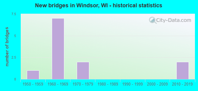
- New bridges - historical statistics
- 11950-1959
- 71960-1969
- 21970-1979
- 22010-2019
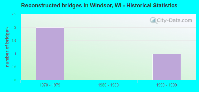
- Reconstructed bridges - Historical Statistics
- 21970-1979
- 01980-1989
- 11990-1999

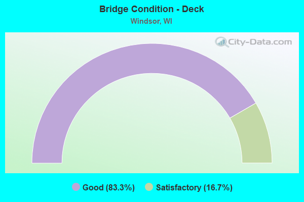
- Bridge Condition - Deck
- 83.3%Good
- 16.7%Satisfactory
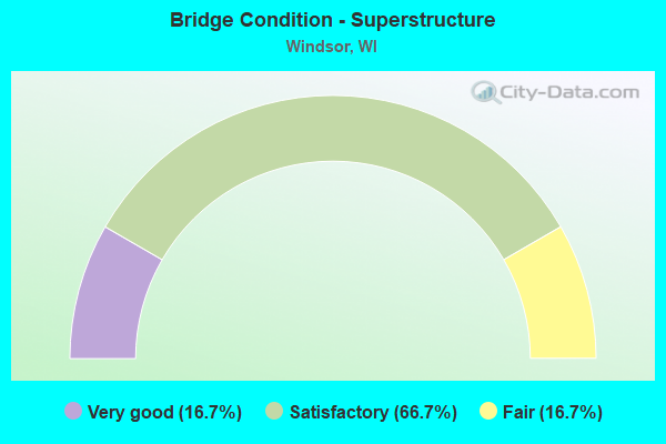
- Bridge Condition - Superstructure
- 16.7%Very good
- 66.7%Satisfactory
- 16.7%Fair
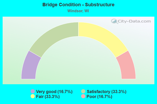
- Bridge Condition - Substructure
- 16.7%Very good
- 33.3%Satisfactory
- 33.3%Fair
- 16.7%Poor
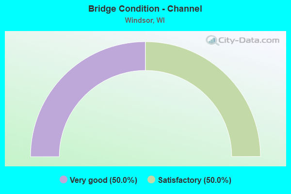
- Bridge Condition - Channel
- 50.0%Very good
- 50.0%Satisfactory
Find on map >> Show street view
Structure Number: B130089, Location: 0.8M W JCT CTH CV (Lat: 43.215236, Lng: -89.361422), Route carried "on" structure: City street , Year Built: 1960, Status: Open, Structure Length: 7.07m (23.20ft), Average Daily Traffic: 2,500 (year 2019), Average Future Daily Traffic: 3,000 (year 2037), Design Load: H 15, Features Intersected: IH 90-IH 94, Facility Carried by Structure: LRD RIVER RD
Minimum Vertical Clearance: 30+ m (98+ ft), Kilometerpoint: 0.000, Lanes on structure: 2, Lanes under structure: 6, Owner: State Highway Agency, Approaching Roadway Width: 8.5m (27.9ft), Skew: 2 degrees, Material/Design: Prestressed concrete, Design/Construction: Stringer/Multi-beam, Number Of Spans In Main Unit: 4, Length of Maximum Span: 22.9m (75.1ft), Curb-To-Curb Width: 7.3m (24.0ft), Out-to-Out Width: 8.5m (27.9ft)
Condition: Deck: Good, Superstructure: Satisfactory, Substructure: Satisfactory, Operating Rating: 37.6 metric tons, Method Used To Determine Operating Rating: Load Factor (LF), Inventory Rating: 32.4 metric tons, Method Used To Determine Inventory Rating: Load Factor (LF), Structural Evaluation: Equal to present minimum criteria, Deck Geometry: High priority of replacement, Underclear: Meets minimum limits, Approach Roadway Alignment: Equal to present minimum criteria, Length Of Structure Improvement: 7.53m (24.70ft), Designated Inspection Frequency: Every 24 months, Inspection Date: October 2021, Bridge Improvement Cost: $800,000, Roadway Improvement Cost: $80,000, Total Project Cost: $1,200,000 ( Estimate for 2021), Deck Structure Type: Concrete Cast-file-Place, Wearing Surface/Protective System: Wearing Surface: Low Slump Concrete
Find on map >> Show street view
Structure Number: B130091, Location: 4M S JCT CTH I (Lat: 43.194753, Lng: -89.345342), Route carried "on" structure: Interstate 39, Year Built: 1960, Year Reconstructed: 1984, Status: Open, Structure Length: 6.21m (20.37ft), Average Daily Traffic: 33,300 (year 2018), Truck Traffic: 13%, Average Future Daily Traffic: 42,150 (year 2040), Design Load: HS 20, Features Intersected: STH 19
Minimum Vertical Clearance: 30+ m (98+ ft), Kilometerpoint: 0.000, Lanes on structure: 3, Lanes under structure: 6, Base Highway Network: Yes, Owner: State Highway Agency, Approaching Roadway Width: 17.1m (56.1ft), Skew: 3 degrees, Material/Design: Steel continuous, Design/Construction: Stringer/Multi-beam, Number Of Spans In Main Unit: 4, Length of Maximum Span: 17.2m (56.4ft), Curb-To-Curb Width: 17.1m (56.1ft), Out-to-Out Width: 17.8m (58.4ft)
Condition: Deck: Good, Superstructure: Satisfactory, Substructure: Satisfactory, Operating Rating: 47.4 metric tons, Method Used To Determine Operating Rating: Load Factor (LF), Inventory Rating: 27.5 metric tons, Method Used To Determine Inventory Rating: Load Factor (LF), Structural Evaluation: Equal to present minimum criteria, Deck Geometry: Equal to present minimum criteria, Underclear: Meets minimum limits, Approach Roadway Alignment: Equal to present desirable criteria, Designated Inspection Frequency: Every 24 months, Inspection Date: August 2021, Deck Structure Type: Concrete Cast-file-Place, Wearing Surface/Protective System: Wearing Surface: Epoxy Overlay, Deck Protection: Epoxy Coated Reinforcing
Find on map >> Show street view
Structure Number: B130092, Location: 1M N JCT USH 51 (Lat: 43.194297, Lng: -89.344333), Route carried "on" structure: Interstate 39, Year Built: 1960, Year Reconstructed: 1984, Status: Open, Structure Length: 6.21m (20.37ft), Average Daily Traffic: 33,300 (year 2018), Truck Traffic: 13%, Average Future Daily Traffic: 42,150 (year 2036), Design Load: HS 20, Features Intersected: STH 19
Minimum Vertical Clearance: 30+ m (98+ ft), Kilometerpoint: 0.000, Lanes on structure: 3, Lanes under structure: 6, Base Highway Network: Yes, Owner: State Highway Agency, Approaching Roadway Width: 17.1m (56.1ft), Skew: 3 degrees, Material/Design: Steel continuous, Design/Construction: Stringer/Multi-beam, Number Of Spans In Main Unit: 4, Length of Maximum Span: 17.2m (56.4ft), Curb-To-Curb Width: 17.1m (56.1ft), Out-to-Out Width: 17.8m (58.4ft)
Condition: Deck: Good, Superstructure: Satisfactory, Substructure: Fair, Operating Rating: 45.7 metric tons, Method Used To Determine Operating Rating: Load Factor (LF), Inventory Rating: 27.5 metric tons, Method Used To Determine Inventory Rating: Load Factor (LF), Structural Evaluation: Somewhat better than minimum adequacy, Deck Geometry: Equal to present minimum criteria, Underclear: Meets minimum limits, Approach Roadway Alignment: Equal to present desirable criteria, Designated Inspection Frequency: Every 24 months, Inspection Date: July 2020, Deck Structure Type: Concrete Cast-file-Place, Wearing Surface/Protective System: Wearing Surface: Epoxy Overlay, Deck Protection: Epoxy Coated Reinforcing
Find on map >> Show street view
Structure Number: B130119, Location: 2.98 MI.S OF CTH V (Lat: 43.209858, Lng: -89.358956), Route carried "on" structure: Interstate 90, Year Built: 1959, Status: Open, Structure Length: 0.81m (2.66ft), Average Daily Traffic: 56,400 (year 2019), Truck Traffic: 17%, Average Future Daily Traffic: 56,500 (year 2040), Design Load: HS 20+Mod, Features Intersected: BR YAHARA RIVER
Minimum Vertical Clearance: 30+ m (98+ ft), Kilometerpoint: 0.000, Lanes on structure: 6, Base Highway Network: Yes, Owner: State Highway Agency, Approaching Roadway Width: 24.4m (80.1ft), Material/Design: Concrete continuous, Design/Construction: Culvert, Number Of Spans In Main Unit: 2, Length of Maximum Span: 3.7m (12.1ft)
Condition: Channel: Satisfactory, Culverts: Good, Operating Rating: 53.9 metric tons, Method Used To Determine Operating Rating: Field evaluation and documented engineering judgment, Inventory Rating: 32.4 metric tons, Method Used To Determine Inventory Rating: Field evaluation and documented engineering judgment, Structural Evaluation: Better than present minimum criteria, Waterway Adequacy: Equal to present desirable criteria, Approach Roadway Alignment: Equal to present desirable criteria, Designated Inspection Frequency: Every 24 months, Inspection Date: August 2021, Deck Structure Type: Concrete Cast-file-Place, Wearing Surface/Protective System: Wearing Surface: Monolithic Concrete
Find on map >> Show street view
Structure Number: B130234, Location: 0.5M W JCT CTH CV (Lat: 43.216306, Lng: -89.349639), Route carried "on" structure: City street , Year Built: 1964, Status: Posted for load, Structure Length: 1.16m (3.81ft), Average Daily Traffic: 822 (year 2019), Average Future Daily Traffic: 904 (year 2040), Design Load: H 15, Features Intersected: YAHARA RIVER, Facility Carried by Structure: LRD WINDSOR RD
Minimum Vertical Clearance: 30+ m (98+ ft), Kilometerpoint: 0.000, Lanes on structure: 2, Owner: Town or Township Highway Agency, Approaching Roadway Width: 9.8m (32.2ft), Material/Design: Steel, Design/Construction: Stringer/Multi-beam, Number Of Spans In Main Unit: 1, Length of Maximum Span: 11.1m (36.4ft), Curb-To-Curb Width: 8.6m (28.2ft), Out-to-Out Width: 9.3m (30.5ft)
Condition: Deck: Satisfactory, Superstructure: Fair, Substructure: Poor, Channel: Very good, Operating Rating: 18.0 metric tons, Method Used To Determine Operating Rating: Field evaluation and documented engineering judgment, Inventory Rating: 11.3 metric tons, Method Used To Determine Inventory Rating: Field evaluation and documented engineering judgment, Structural Evaluation: High priority of replacement, Deck Geometry: Somewhat better than minimum adequacy, Waterway Adequacy: Equal to present desirable criteria, Approach Roadway Alignment: Equal to present desirable criteria, Bridge Posting: Required (Relationship of Operating Rating to Maximum Legal Load: 0.1 - 9.9% below), Length Of Structure Improvement: 1.62m (5.31ft), Designated Inspection Frequency: Every 12 months, Inspection Date: October 2021, Bridge Improvement Cost: $171,000, Roadway Improvement Cost: $17,000, Total Project Cost: $257,000 ( Estimate for 2021), Deck Structure Type: Concrete Cast-file-Place, Wearing Surface/Protective System: Wearing Surface: Bituminous
Find on map >> Show street view
Structure Number: B130292, Location: 4.0M S JCT CTH V TO W (Lat: 43.195050, Lng: -89.324903), Route carried "on" structure: US 51, Year Built: 1971, Year Reconstructed: 2004, Status: Open, Structure Length: 6.17m (20.24ft), Average Daily Traffic: 6,355 (year 2019), Truck Traffic: 10%, Average Future Daily Traffic: 22,150 (year 2039), Design Load: HS 20, Features Intersected: STH 19
Minimum Vertical Clearance: 30+ m (98+ ft), Kilometerpoint: 0.000, Lanes on structure: 2, Lanes under structure: 6, Base Highway Network: Yes, Owner: State Highway Agency, Approaching Roadway Width: 12.8m (42.0ft), Material/Design: Prestressed concrete continuous, Design/Construction: Stringer/Multi-beam, Number Of Spans In Main Unit: 2, Length of Maximum Span: 31.5m (103.3ft), Curb-To-Curb Width: 12.2m (40.0ft), Out-to-Out Width: 13.0m (42.7ft)
Condition: Deck: Good, Superstructure: Satisfactory, Substructure: Fair, Operating Rating: 70.2 metric tons, Method Used To Determine Operating Rating: Load Factor (LF), Inventory Rating: 30.8 metric tons, Method Used To Determine Inventory Rating: Load Factor (LF), Structural Evaluation: Somewhat better than minimum adequacy, Deck Geometry: Better than present minimum criteria, Underclear: Equal to present minimum criteria, Approach Roadway Alignment: Equal to present desirable criteria, Designated Inspection Frequency: Every 24 months, Inspection Date: October 2020, Deck Structure Type: Concrete Cast-file-Place, Wearing Surface/Protective System: Wearing Surface: Monolithic Concrete, Deck Protection: Epoxy Coated Reinforcing
Find on map >> Show street view
Structure Number: B130595, Location: 2.5 MI. S OF CTH V TO W (Lat: 43.216611, Lng: -89.323167), Route carried "on" structure: US 51, Year Built: 2013, Status: Open, Structure Length: 4.93m (16.17ft), Average Daily Traffic: 28,800 (year 2019), Average Future Daily Traffic: 28,800 (year 2040), Design Load: HL 93, Features Intersected: LRD WINDSOR ROAD
Minimum Vertical Clearance: 30+ m (98+ ft), Kilometerpoint: 0.000, Lanes on structure: 2, Lanes under structure: 4, Base Highway Network: Yes, Owner: State Highway Agency, Approaching Roadway Width: 12.2m (40.0ft), Material/Design: Prestressed concrete continuous, Design/Construction: Stringer/Multi-beam, Number Of Spans In Main Unit: 2, Length of Maximum Span: 24.1m (79.1ft), Curb-To-Curb Width: 12.2m (40.0ft), Out-to-Out Width: 13.3m (43.6ft)
Condition: Deck: Good, Superstructure: Very good, Substructure: Very good, Operating Rating: 44.7 metric tons, Method Used To Determine Operating Rating: Load and Resistance Factor Rating (LRFR) rating reported by rating factor(RF) method using HL-93 loadings, Inventory Rating: 34.3 metric tons, Method Used To Determine Inventory Rating: Load and Resistance Factor Rating (LRFR) rating reported by rating factor(RF) method using HL-93 loadings, Structural Evaluation: Equal to present desirable criteria, Deck Geometry: Better than present minimum criteria, Underclear: Equal to present minimum criteria, Approach Roadway Alignment: Equal to present desirable criteria, Designated Inspection Frequency: Every 48 months, Inspection Date: November 2021, Deck Structure Type: Concrete Cast-file-Place, Wearing Surface/Protective System: Wearing Surface: Monolithic Concrete, Deck Protection: Epoxy Coated Reinforcing
Find on map >> Show street view
Structure Number: B130089, Location: 2.7M E JCT CTH V TO E (Lat: 43.215236, Lng: -89.361422), Route carried "under" structure: Interstate 90, Year Built: 1960, Structure Length: 0. m, Average Daily Traffic: 56,900 (year 2019), Truck Traffic: 16%, Features Intersected: IH 90-IH 94, Facility Carried by Structure: LRD RIVER RD
Minimum Vertical Clearance: 4.91m (16.11ft), Kilometerpoint: 0.000, Lanes on structure: 2, Lanes under structure: 6, Material/Design: Prestressed concrete, Design/Construction: Stringer/Multi-beam, Length of Maximum Span: 22.9m (75.1ft)
Find on map >> Show street view
Structure Number: B130091, Location: 3.6M E JCT CTH I (Lat: 43.194753, Lng: -89.345342), Route carried "under" structure: State highway 19, Year Built: 1960, Structure Length: 0. m, Average Daily Traffic: 15,800 (year 2020), Truck Traffic: 5%, Features Intersected: STH 19, Facility Carried by Structure: IH 39 SB / IH 90/9
Minimum Vertical Clearance: 4.85m (15.91ft), Kilometerpoint: 0.000, Lanes on structure: 3, Lanes under structure: 6, Material/Design: Steel continuous, Design/Construction: Stringer/Multi-beam, Length of Maximum Span: 17.2m (56.4ft)
Find on map >> Show street view
Structure Number: B130092, Location: 3.6M E JCT CTH I (Lat: 43.194297, Lng: -89.344333), Route carried "under" structure: State highway 19, Year Built: 1960, Structure Length: 0. m, Average Daily Traffic: 15,800 (year 2020), Truck Traffic: 5%, Features Intersected: STH 19, Facility Carried by Structure: IH 39 NB / IH 90/9
Minimum Vertical Clearance: 4.60m (15.09ft), Kilometerpoint: 0.000, Lanes on structure: 3, Lanes under structure: 6, Material/Design: Steel continuous, Design/Construction: Stringer/Multi-beam, Length of Maximum Span: 17.2m (56.4ft)
Find on map >> Show street view
Structure Number: B130292, Location: 1.0M E JCT IH 90 TO W (Lat: 43.195050, Lng: -89.324903), Route carried "under" structure: State highway 19, Year Built: 1971, Structure Length: 0. m, Average Daily Traffic: 13,800 (year 2019), Truck Traffic: 5%, Features Intersected: STH 19, Facility Carried by Structure: USH 51 SB
Minimum Vertical Clearance: 4.65m (15.26ft), Kilometerpoint: 0.000, Lanes on structure: 2, Lanes under structure: 6, Material/Design: Prestressed concrete continuous, Design/Construction: Stringer/Multi-beam, Length of Maximum Span: 31.5m (103.3ft)
Find on map >> Show street view
Structure Number: B130595, Location: AT 51 (Lat: 43.216611, Lng: -89.323167), Route carried "under" structure: City street , Year Built: 2013, Structure Length: 0. m, Average Daily Traffic: 13,381 (year 2019), Features Intersected: LRD WINDSOR ROAD, Facility Carried by Structure: USH 51 SB
Minimum Vertical Clearance: 4.57m (14.99ft), Kilometerpoint: 0.000, Lanes on structure: 2, Lanes under structure: 4, Material/Design: Prestressed concrete continuous, Design/Construction: Stringer/Multi-beam, Length of Maximum Span: 24.1m (79.1ft)