Bridge Statistics for Woodbury Heights, New Jersey (NJ)
Condition, Traffic, Stress, Structural Evaluation, Project Costs
- National Bridge Inventory (NBI) Statistics
- 12Number of bridges
- 167ft / 50.7mTotal length
- $9,344,000Total costs
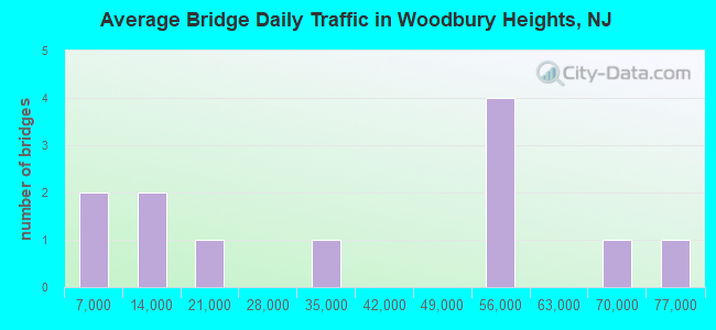
- 433,542Total average daily traffic
- 25,551Total average daily truck traffic
- National Bridge Inventory (NBI) Registered Bridges for Woodbury Heights
- No street view available for this location
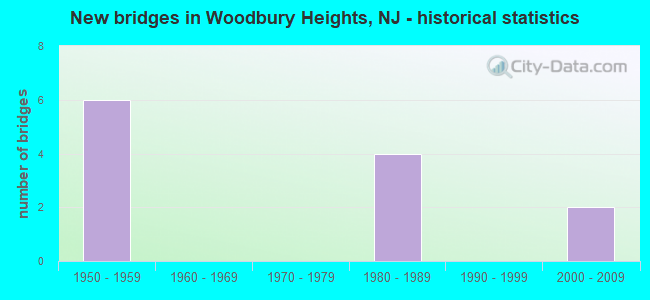
- New bridges - historical statistics
- 61950-1959
- 41980-1989
- 22000-2009
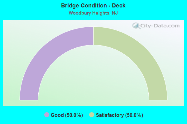
- Bridge Condition - Deck
- 50.0%Good
- 50.0%Satisfactory
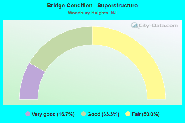
- Bridge Condition - Superstructure
- 16.7%Very good
- 33.3%Good
- 50.0%Fair
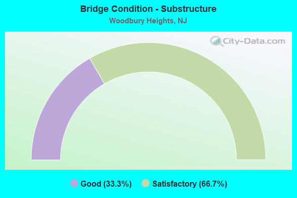
- Bridge Condition - Substructure
- 33.3%Good
- 66.7%Satisfactory
Find on map >> Show street view
Structure Number: 832162, Location: .26 miles SE. of CR 647 (Lat: 39.794811, Lng: -75.114961), Route carried "on" structure: State highway 47, Year Built: 1985, Status: Open, Structure Length: 11.31m (37.11ft), Average Daily Traffic: 12,618 (year 2021), Truck Traffic: 4%, Average Future Daily Traffic: 17,815 (year 2041), Design Load: HS 20+Mod, Features Intersected: NJ 55
Minimum Vertical Clearance: 30+ m (98+ ft), Kilometerpoint: 111.640, Lanes on structure: 4, Lanes under structure: 6, Owner: State Highway Agency, Approaching Roadway Width: 22.6m (74.1ft), Skew: 2 degrees, Material/Design: Steel continuous, Design/Construction: Stringer/Multi-beam, Number Of Spans In Main Unit: 3, Length of Maximum Span: 44.2m (145.0ft), Curb or Sidewalk Widths: Left: 1.8m (5.9ft), Right: 1.8m (5.9ft), Curb-To-Curb Width: 22.6m (74.1ft), Out-to-Out Width: 26.8m (87.9ft)
Condition: Deck: Good, Superstructure: Good, Substructure: Good, Inventory Rating: 58.1 metric tons, Method Used To Determine Inventory Rating: Load Factor (LF), Structural Evaluation: Better than present minimum criteria, Deck Geometry: Superior to present desirable criteria, Underclear: Better than present minimum criteria, Approach Roadway Alignment: Equal to present desirable criteria, Designated Inspection Frequency: Every 24 months, Inspection Date: June 2021, Deck Structure Type: Concrete Cast-file-Place, Wearing Surface/Protective System: Wearing Surface: Monolithic Concrete, Deck Protection: Epoxy Coated Reinforcing
Find on map >> Show street view
Structure Number: 832164, Location: 1.5 MILES N OF NJ 47 (Lat: 39.813161, Lng: -75.105581), Route carried "on" structure: County highway 534, Year Built: 1984, Status: Open, Structure Length: 11.22m (36.81ft), Average Daily Traffic: 7,765 (year 2021), Truck Traffic: 3%, Average Future Daily Traffic: 9,320 (year 2041), Design Load: HS 20+Mod, Features Intersected: NJ 55
Minimum Vertical Clearance: 30+ m (98+ ft), Kilometerpoint: 3.331, Lanes on structure: 2, Lanes under structure: 4, Owner: State Highway Agency, Approaching Roadway Width: 12.2m (40.0ft), Skew: 3 degrees, Material/Design: Steel continuous, Design/Construction: Stringer/Multi-beam, Number Of Spans In Main Unit: 3, Length of Maximum Span: 44.2m (145.0ft), Curb or Sidewalk Widths: Left: 1.8m (5.9ft), Right: 1.8m (5.9ft), Curb-To-Curb Width: 12.2m (40.0ft), Out-to-Out Width: 16.5m (54.1ft)
Condition: Deck: Good, Superstructure: Very good, Substructure: Satisfactory, Inventory Rating: 71.7 metric tons, Method Used To Determine Inventory Rating: Load Factor (LF), Structural Evaluation: Equal to present minimum criteria, Deck Geometry: Somewhat better than minimum adequacy, Underclear: Equal to present minimum criteria, Approach Roadway Alignment: Equal to present minimum criteria, Designated Inspection Frequency: Every 24 months, Inspection Date: September 2021, Deck Structure Type: Concrete Cast-file-Place, Wearing Surface/Protective System: Wearing Surface: Latex Concrete, Deck Protection: Epoxy Coated Reinforcing
Find on map >> Show street view
Structure Number: M02023R, Location: 7 MI NORTH OF EXIT 2 (Lat: 39.815828, Lng: -75.164094), Route carried "on" structure: State highway 45, Year Built: 2007, Status: Open, Structure Length: 7.62m (25.00ft), Average Daily Traffic: 29,733 (year 2020), Truck Traffic: 5%, Average Future Daily Traffic: 35,679 (year 2040), Design Load: HS 20, Features Intersected: NJ TURNPIKE
Minimum Vertical Clearance: 30+ m (98+ ft), Kilometerpoint: 39.027, Lanes on structure: 4, Lanes under structure: 4, Base Highway Network: Yes, Owner: State Toll Authority, Approaching Roadway Width: 27.1m (88.9ft), Skew: 34 degrees, Material/Design: Steel continuous, Design/Construction: Stringer/Multi-beam, Number Of Spans In Main Unit: 2, Length of Maximum Span: 37.2m (122.0ft), Curb or Sidewalk Widths: Left: 1.8m (5.9ft), Right: 1.8m (5.9ft), Curb-To-Curb Width: 26.0m (85.3ft), Out-to-Out Width: 31.1m (102.0ft)
Condition: Deck: Good, Superstructure: Good, Substructure: Good, Operating Rating: 40.5 metric tons, Method Used To Determine Operating Rating: Load and Resistance Factor Rating (LRFR) rating reported by rating factor(RF) method using HL-93 loadings, Inventory Rating: 31.1 metric tons, Method Used To Determine Inventory Rating: Load and Resistance Factor Rating (LRFR) rating reported by rating factor(RF) method using HL-93 loadings, Structural Evaluation: Better than present minimum criteria, Deck Geometry: Superior to present desirable criteria, Underclear: High priority of corrective action, Approach Roadway Alignment: Equal to present desirable criteria, Length Of Structure Improvement: 7.62m (25.00ft), Designated Inspection Frequency: Every 24 months, Inspection Date: March 2020, Bridge Improvement Cost: $212,000, Roadway Improvement Cost: $106,000, Total Project Cost: $318,000 ( Estimate for 2016), Deck Structure Type: Concrete Cast-file-Place, Wearing Surface/Protective System: Wearing Surface: Monolithic Concrete, Deck Protection: Epoxy Coated Reinforcing
Find on map >> Show street view
Structure Number: M02047, Location: 6 MI SOUTH OF EXIT 3 (Lat: 39.817511, Lng: -75.160044), Route carried "on" structure: County highway 652, Year Built: 1951, Status: Open, Structure Length: 7.68m (25.20ft), Average Daily Traffic: 5,310 (year 2020), Truck Traffic: 4%, Average Future Daily Traffic: 6,371 (year 2040), Design Load: H 20, Features Intersected: NJ TURNPIKE, Facility Carried by Structure: ELM AVE
Minimum Vertical Clearance: 30+ m (98+ ft), Kilometerpoint: 0.257, Lanes on structure: 2, Lanes under structure: 4, Owner: State Toll Authority, Approaching Roadway Width: 10.4m (34.1ft), Skew: 4 degrees, Material/Design: Steel continuous, Design/Construction: Stringer/Multi-beam, Number Of Spans In Main Unit: 4, Length of Maximum Span: 23.5m (77.1ft), Curb or Sidewalk Widths: Left: 1.2m (3.9ft), Right: 1.2m (3.9ft), Curb-To-Curb Width: 10.4m (34.1ft), Out-to-Out Width: 13.4m (44.0ft)
Condition: Deck: Satisfactory, Superstructure: Fair, Substructure: Satisfactory, Operating Rating: 40.8 metric tons, Method Used To Determine Operating Rating: Load Factor (LF), Inventory Rating: 24.1 metric tons, Method Used To Determine Inventory Rating: Load Factor (LF), Structural Evaluation: Somewhat better than minimum adequacy, Deck Geometry: Meets minimum limits, Underclear: High priority of corrective action, Approach Roadway Alignment: Equal to present desirable criteria, Length Of Structure Improvement: 7.68m (25.20ft), Designated Inspection Frequency: Every 24 months, Inspection Date: March 2020, Bridge Improvement Cost: $5,406,000, Roadway Improvement Cost: $1,136,000, Total Project Cost: $9,026,000 ( Estimate for 2018), Deck Structure Type: Concrete Cast-file-Place, Wearing Surface/Protective System: Wearing Surface: Monolithic Concrete
Find on map >> Show street view
Structure Number: M02096, Location: 5.2 MI SOUTH OF EXIT 3 (Lat: 39.820881, Lng: -75.152633), Route carried "on" structure: Other road NJTPK, Year Built: 1950, Status: Open, Structure Length: 8.20m (26.90ft), Average Daily Traffic: 54,953 (year 2020), Truck Traffic: 11%, Average Future Daily Traffic: 67,053 (year 2040), Design Load: HS 20, Features Intersected: WEST JERSEY AVE & PRSL, Facility Carried by Structure: NJ TURNPIKE
Minimum Vertical Clearance: 30+ m (98+ ft), Kilometerpoint: 34.070, Lanes on structure: 4, Lanes under structure: 4, Base Highway Network: Yes, Toll: On toll road, Owner: State Toll Authority, Approaching Roadway Width: 29.3m (96.1ft), Skew: 32 degrees, Material/Design: Steel continuous, Design/Construction: Stringer/Multi-beam, Number Of Spans In Main Unit: 5, Length of Maximum Span: 21.9m (71.9ft), Curb or Sidewalk Widths: Left: 0.6m (2.0ft), Right: 0.0m, Curb-To-Curb Width: 27.8m (91.2ft), Out-to-Out Width: 30.5m (100.1ft)
Condition: Deck: Satisfactory, Superstructure: Fair, Substructure: Satisfactory, Operating Rating: 22.4 metric tons, Method Used To Determine Operating Rating: Load and Resistance Factor Rating (LRFR) rating reported by rating factor(RF) method using HL-93 loadings, Inventory Rating: 17.2 metric tons, Method Used To Determine Inventory Rating: Load and Resistance Factor Rating (LRFR) rating reported by rating factor(RF) method using HL-93 loadings, Structural Evaluation: Meets minimum limits, Deck Geometry: Superior to present desirable criteria, Underclear: Meets minimum limits, Approach Roadway Alignment: Equal to present desirable criteria, Designated Inspection Frequency: Every 24 months, Inspection Date: March 2020, Deck Structure Type: Concrete Cast-file-Place, Wearing Surface/Protective System: Wearing Surface: Bituminous, Membrane: Preformed Fabric
Find on map >> Show street view
Structure Number: M02108, Location: 5 MI SOUTH OF EXIT 3 (Lat: 39.821861, Lng: -75.150539), Route carried "on" structure: Other road NJTPK, Year Built: 1951, Status: Open, Structure Length: 4.69m (15.39ft), Average Daily Traffic: 54,952 (year 2020), Truck Traffic: 5%, Average Future Daily Traffic: 67,052 (year 2040), Design Load: HS 20, Features Intersected: N. GLASSBORO RD, Facility Carried by Structure: NJ TURNPIKE
Minimum Vertical Clearance: 30+ m (98+ ft), Kilometerpoint: 34.279, Lanes on structure: 4, Lanes under structure: 2, Base Highway Network: Yes, Toll: On toll road, Owner: State Toll Authority, Approaching Roadway Width: 29.3m (96.1ft), Skew: 31 degrees, Material/Design: Steel continuous, Design/Construction: Stringer/Multi-beam, Number Of Spans In Main Unit: 3, Length of Maximum Span: 18.9m (62.0ft), Curb or Sidewalk Widths: Left: 0.6m (2.0ft), Right: 0.6m (2.0ft), Curb-To-Curb Width: 27.7m (90.9ft), Out-to-Out Width: 30.5m (100.1ft)
Condition: Deck: Satisfactory, Superstructure: Fair, Substructure: Satisfactory, Operating Rating: 37.9 metric tons, Method Used To Determine Operating Rating: Load and Resistance Factor Rating (LRFR) rating reported by rating factor(RF) method using HL-93 loadings, Inventory Rating: 29.2 metric tons, Method Used To Determine Inventory Rating: Load and Resistance Factor Rating (LRFR) rating reported by rating factor(RF) method using HL-93 loadings, Structural Evaluation: Somewhat better than minimum adequacy, Deck Geometry: Superior to present desirable criteria, Underclear: Equal to present minimum criteria, Approach Roadway Alignment: Equal to present desirable criteria, Designated Inspection Frequency: Every 24 months, Inspection Date: March 2020, Deck Structure Type: Concrete Cast-file-Place, Wearing Surface/Protective System: Wearing Surface: Bituminous, Membrane: Epoxy
Find on map >> Show street view
Structure Number: 832162, Location: .26 miles SE. of CR 647 (Lat: 39.794811, Lng: -75.114961), Route carried "under" structure: State highway 55, Year Built: 1985, Structure Length: 0. m, Average Daily Traffic: 74,482 (year 2021), Truck Traffic: 5%, Features Intersected: NJ 55, Facility Carried by Structure: NJ 47
Minimum Vertical Clearance: 5.46m (17.91ft), Kilometerpoint: 90.719, Lanes on structure: 4, Lanes under structure: 6, Material/Design: Steel continuous, Design/Construction: Stringer/Multi-beam, Length of Maximum Span: 44.2m (145.0ft)
Find on map >> Show street view
Structure Number: 832164, Location: 1.5 MILES N OF NJ 47 (Lat: 39.813161, Lng: -75.105581), Route carried "under" structure: State highway 55, Year Built: 1984, Structure Length: 0. m, Average Daily Traffic: 67,715 (year 2021), Truck Traffic: 5%, Features Intersected: NJ 55, Facility Carried by Structure: GOOD INTENT RD-534
Minimum Vertical Clearance: 5.36m (17.59ft), Kilometerpoint: 93.117, Lanes on structure: 2, Lanes under structure: 4, Material/Design: Steel continuous, Design/Construction: Stringer/Multi-beam, Length of Maximum Span: 44.2m (145.0ft)
Find on map >> Show street view
Structure Number: M02023R, Location: 7 MI NORTH OF EXIT 2 (Lat: 39.815828, Lng: -75.164094), Route carried "under" structure: Other road NJTPK, Year Built: 2007, Structure Length: 0. m, Average Daily Traffic: 54,953 (year 2020), Truck Traffic: 5%, Features Intersected: NJ TURNPIKE, Facility Carried by Structure: NJ 45 (MANTUA PIK)
Minimum Vertical Clearance: 4.57m (14.99ft), Kilometerpoint: 32.895, Lanes on structure: 4, Lanes under structure: 4, Toll: On toll road, Material/Design: Steel continuous, Design/Construction: Stringer/Multi-beam, Length of Maximum Span: 37.2m (122.0ft)
Find on map >> Show street view
Structure Number: M02047, Location: 6 MI SOUTH OF EXIT 3 (Lat: 39.817511, Lng: -75.160044), Route carried "under" structure: Other road NJTPK, Year Built: 1951, Structure Length: 0. m, Average Daily Traffic: 54,954 (year 2020), Truck Traffic: 7%, Features Intersected: NJ TURNPIKE, Facility Carried by Structure: ELM AVE
Minimum Vertical Clearance: 4.90m (16.08ft), Kilometerpoint: 33.281, Lanes on structure: 2, Lanes under structure: 4, Toll: On toll road, Material/Design: Steel continuous, Design/Construction: Stringer/Multi-beam, Length of Maximum Span: 23.5m (77.1ft)
Find on map >> Show street view
Structure Number: M02096, Location: 5.2 MI SOUTH OF EXIT 3 (Lat: 39.820881, Lng: -75.152633), Route carried "under" structure: Alternate City street , Year Built: 1950, Structure Length: 0. m, Average Daily Traffic: 656 (year 2020), Truck Traffic: 1%, Features Intersected: WEST JERSEY AVE & PRSL, Facility Carried by Structure: NJ TURNPIKE
Minimum Vertical Clearance: 7.32m (24.02ft), Kilometerpoint: 0.000, Lanes on structure: 4, Lanes under structure: 2, Material/Design: Steel continuous, Design/Construction: Stringer/Multi-beam, Length of Maximum Span: 21.9m (71.9ft)
Find on map >> Show street view
Structure Number: M02108, Location: 5 MI SOUTH OF EXIT 3 (Lat: 39.821861, Lng: -75.150539), Route carried "under" structure: County highway 553, Year Built: 1951, Structure Length: 0. m, Average Daily Traffic: 15,451 (year 2020), Truck Traffic: 4%, Features Intersected: N. GLASSBORO RD, Facility Carried by Structure: NJ TURNPIKE
Minimum Vertical Clearance: 6.65m (21.82ft), Kilometerpoint: 78.729, Lanes on structure: 4, Lanes under structure: 2, Material/Design: Steel continuous, Design/Construction: Stringer/Multi-beam, Length of Maximum Span: 18.9m (62.0ft)