Bridge Statistics for Woodbury, Minnesota (MN)
Condition, Traffic, Stress, Structural Evaluation, Project Costs
- National Bridge Inventory (NBI) Statistics
- 30Number of bridges
- 341ft / 104mTotal length
- $859,000Total costs
- 1,284,994Total average daily traffic
- 95,477Total average daily truck traffic
- National Bridge Inventory (NBI) Registered Bridges for Woodbury
- No street view available for this location
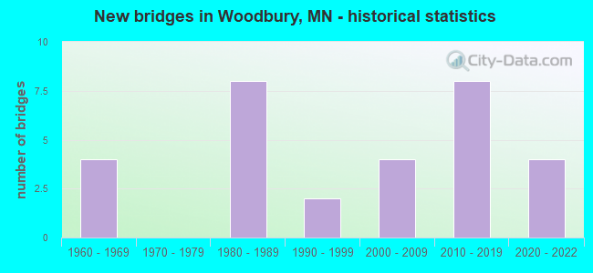
- New bridges - historical statistics
- 41960-1969
- 81980-1989
- 21990-1999
- 42000-2009
- 82010-2019
- 42020-2022
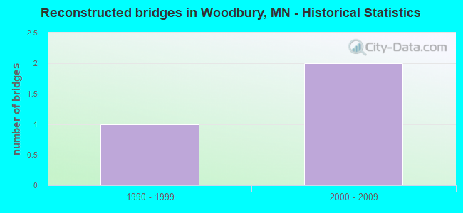
- Reconstructed bridges - Historical Statistics
- 11990-1999
- 22000-2009
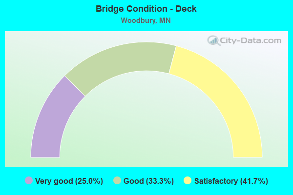
- Bridge Condition - Deck
- 25.0%Very good
- 33.3%Good
- 41.7%Satisfactory
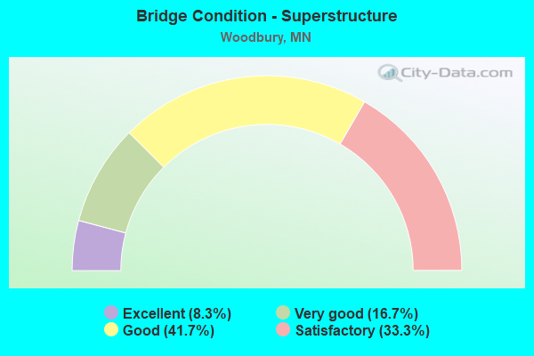
- Bridge Condition - Superstructure
- 8.3%Excellent
- 16.7%Very good
- 41.7%Good
- 33.3%Satisfactory
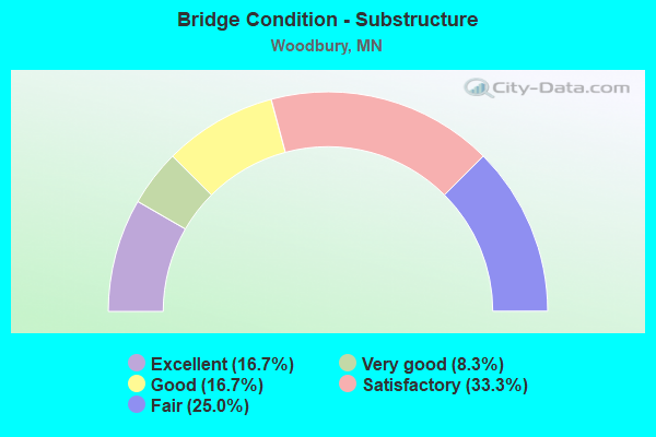
- Bridge Condition - Substructure
- 16.7%Excellent
- 8.3%Very good
- 16.7%Good
- 33.3%Satisfactory
- 25.0%Fair
Find on map >> Show street view
Structure Number: 82016, Location: 1.7 MI S OF JCT TH 94 (Lat: 44.925739, Lng: -92.968794), Route carried "on" structure: County highway 16, Year Built: 2006, Status: Open, Structure Length: 7.52m (24.67ft), Average Daily Traffic: 20,400 (year 2015), Average Future Daily Traffic: 20,400 (year 2039), Design Load: HL 93, Features Intersected: I 494
Minimum Vertical Clearance: 30+ m (98+ ft), Kilometerpoint: 0.000, Lanes on structure: 5, Lanes under structure: 4, Owner: State Highway Agency, Approaching Roadway Width: 24.4m (80.1ft), Skew: 22 degrees, Material/Design: Prestressed concrete, Design/Construction: Stringer/Multi-beam, Number Of Spans In Main Unit: 2, Length of Maximum Span: 36.7m (120.4ft), Curb or Sidewalk Widths: Left: 3.0m (9.8ft), Right: 3.0m (9.8ft), Curb-To-Curb Width: 32.9m (107.9ft), Out-to-Out Width: 40.3m (132.2ft)
Condition: Deck: Good, Superstructure: Good, Substructure: Fair, Operating Rating: 77.5 metric tons, Method Used To Determine Operating Rating: Load Factor (LF), Inventory Rating: 37.9 metric tons, Method Used To Determine Inventory Rating: Load Factor (LF), Structural Evaluation: Somewhat better than minimum adequacy, Deck Geometry: Superior to present desirable criteria, Underclear: Somewhat better than minimum adequacy, Approach Roadway Alignment: Equal to present desirable criteria, Designated Inspection Frequency: Every 24 months, Inspection Date: September 2021, Deck Structure Type: Concrete Cast-file-Place, Wearing Surface/Protective System: Wearing Surface: Monolithic Concrete, Deck Protection: Epoxy Coated Reinforcing
Find on map >> Show street view
Structure Number: 82511, Location: 0.9 MI SW OF JCT TH 120 (Lat: 44.916211, Lng: -92.979500), Route carried "on" structure: City street 108, Year Built: 1994, Status: Open, Structure Length: 8.77m (28.77ft), Average Daily Traffic: 9,400 (year 2015), Average Future Daily Traffic: 9,400 (year 2039), Design Load: HS 25 or greater, Features Intersected: I 494
Minimum Vertical Clearance: 30+ m (98+ ft), Kilometerpoint: 0.000, Lanes on structure: 4, Lanes under structure: 6, Owner: State Highway Agency, Approaching Roadway Width: 22.6m (74.1ft), Skew: 20 degrees, Material/Design: Prestressed concrete, Design/Construction: Stringer/Multi-beam, Number Of Spans In Main Unit: 2, Length of Maximum Span: 45.0m (147.6ft), Curb or Sidewalk Widths: Left: 3.0m (9.8ft), Right: 0.0m, Curb-To-Curb Width: 17.7m (58.1ft), Out-to-Out Width: 27.1m (88.9ft)
Condition: Deck: Satisfactory, Superstructure: Good, Substructure: Fair, Operating Rating: 81.8 metric tons, Method Used To Determine Operating Rating: Load Factor (LF), Inventory Rating: 53.2 metric tons, Method Used To Determine Inventory Rating: Load Factor (LF), Structural Evaluation: Somewhat better than minimum adequacy, Deck Geometry: Somewhat better than minimum adequacy, Underclear: Somewhat better than minimum adequacy, Approach Roadway Alignment: Equal to present desirable criteria, Designated Inspection Frequency: Every 24 months, Inspection Date: August 2021, Deck Structure Type: Concrete Cast-file-Place, Wearing Surface/Protective System: Wearing Surface: Low Slump Concrete, Deck Protection: Epoxy Coated Reinforcing
Find on map >> Show street view
Structure Number: 82518, Location: 0.9 MI S OF JCT 94; 494 (Lat: 44.936506, Lng: -92.960608), Route carried "on" structure: City street 102, Year Built: 2003, Status: Open, Structure Length: 17.94m (58.86ft), Average Daily Traffic: 22,000 (year 2015), Average Future Daily Traffic: 22,000 (year 2039), Design Load: HS 25 or greater, Features Intersected: I 494
Minimum Vertical Clearance: 30+ m (98+ ft), Kilometerpoint: 0.000, Lanes on structure: 4, Lanes under structure: 6, Owner: State Highway Agency, Approaching Roadway Width: 21.9m (71.9ft), Skew: 21 degrees, Material/Design: Prestressed concrete, Design/Construction: Stringer/Multi-beam, Number Of Spans In Main Unit: 5, Length of Maximum Span: 35.7m (117.1ft), Curb or Sidewalk Widths: Left: 0.0m, Right: 3.7m (12.1ft), Curb-To-Curb Width: 21.9m (71.9ft), Out-to-Out Width: 31.3m (102.7ft)
Condition: Deck: Good, Superstructure: Satisfactory, Substructure: Satisfactory, Operating Rating: 59.6 metric tons, Method Used To Determine Operating Rating: Load and Resistance Factor Rating (LRFR) rating reported by rating factor(RF) method using HL-93 loadings, Inventory Rating: 42.4 metric tons, Method Used To Determine Inventory Rating: Load and Resistance Factor Rating (LRFR) rating reported by rating factor(RF) method using HL-93 loadings, Structural Evaluation: Equal to present minimum criteria, Deck Geometry: Superior to present desirable criteria, Underclear: Better than present minimum criteria, Approach Roadway Alignment: Equal to present desirable criteria, Designated Inspection Frequency: Every 24 months, Inspection Date: August 2021, Deck Structure Type: Concrete Cast-file-Place, Wearing Surface/Protective System: Wearing Surface: Low Slump Concrete, Deck Protection: Epoxy Coated Reinforcing
Find on map >> Show street view
Structure Number: 82843, Location: 1.2 MI E OF JCT TH 494 (Lat: 44.948628, Lng: -92.934517), Route carried "on" structure: County highway 13, Year Built: 1983, Status: Open, Structure Length: 7.94m (26.05ft), Average Daily Traffic: 18,000 (year 2017), Average Future Daily Traffic: 18,000 (year 2039), Design Load: HS 20, Features Intersected: I 94
Minimum Vertical Clearance: 30+ m (98+ ft), Kilometerpoint: 0.000, Lanes on structure: 2, Lanes under structure: 6, Owner: State Highway Agency, Approaching Roadway Width: 11.6m (38.1ft), Skew: 1 degrees, Material/Design: Prestressed concrete, Design/Construction: Stringer/Multi-beam, Number Of Spans In Main Unit: 2, Length of Maximum Span: 39.0m (128.0ft), Curb or Sidewalk Widths: Left: 0.0m, Right: 1.9m (6.2ft), Curb-To-Curb Width: 12.1m (39.7ft), Out-to-Out Width: 15.1m (49.5ft)
Condition: Deck: Good, Superstructure: Good, Substructure: Satisfactory, Operating Rating: 79.6 metric tons, Method Used To Determine Operating Rating: Load Factor (LF), Inventory Rating: 43.7 metric tons, Method Used To Determine Inventory Rating: Load Factor (LF), Structural Evaluation: Equal to present minimum criteria, Deck Geometry: Better than present minimum criteria, Underclear: Somewhat better than minimum adequacy, Approach Roadway Alignment: Equal to present desirable criteria, Designated Inspection Frequency: Every 24 months, Inspection Date: August 2021, Deck Structure Type: Concrete Cast-file-Place, Wearing Surface/Protective System: Wearing Surface: Low Slump Concrete, Deck Protection: Epoxy Coated Reinforcing
Find on map >> Show street view
Structure Number: 82844, Location: 2.7 MI E OF JCT TH 494 (Lat: 44.948594, Lng: -92.903167), Route carried "on" structure: County highway 19, Year Built: 1983, Year Reconstructed: 2007, Status: Open, Structure Length: 8.37m (27.46ft), Average Daily Traffic: 33,500 (year 2017), Average Future Daily Traffic: 33,500 (year 2039), Design Load: HS 20, Features Intersected: I 94
Minimum Vertical Clearance: 30+ m (98+ ft), Kilometerpoint: 0.000, Lanes on structure: 4, Lanes under structure: 6, Owner: State Highway Agency, Approaching Roadway Width: 54.6m (179.1ft), Skew: 20 degrees, Material/Design: Steel continuous, Design/Construction: Stringer/Multi-beam, Number Of Spans In Main Unit: 2, Length of Maximum Span: 41.1m (134.8ft), Curb or Sidewalk Widths: Left: 0.0m, Right: 2.6m (8.5ft), Curb-To-Curb Width: 30.2m (99.1ft), Out-to-Out Width: 37.4m (122.7ft)
Condition: Deck: Satisfactory, Superstructure: Satisfactory, Substructure: Good, Operating Rating: 77.1 metric tons, Method Used To Determine Operating Rating: Load Factor (LF), Inventory Rating: 46.1 metric tons, Method Used To Determine Inventory Rating: Load Factor (LF), Structural Evaluation: Equal to present minimum criteria, Deck Geometry: Superior to present desirable criteria, Underclear: Equal to present minimum criteria, Approach Roadway Alignment: Equal to present desirable criteria, Designated Inspection Frequency: Every 24 months, Inspection Date: August 2021, Deck Structure Type: Concrete Cast-file-Place, Wearing Surface/Protective System: Wearing Surface: Low Slump Concrete, Deck Protection: Epoxy Coated Reinforcing
Find on map >> Show street view
Structure Number: 82845, Location: 3.7 MI E OF JCT TH 494 (Lat: 44.948631, Lng: -92.883094), Route carried "on" structure: City street 127, Year Built: 1983, Status: Open, Structure Length: 10.03m (32.91ft), Average Daily Traffic: 2,500 (year 2015), Average Future Daily Traffic: 2,500 (year 2039), Design Load: HS 20, Features Intersected: I 94
Minimum Vertical Clearance: 30+ m (98+ ft), Kilometerpoint: 0.000, Lanes on structure: 2, Lanes under structure: 6, Owner: State Highway Agency, Approaching Roadway Width: 14.0m (45.9ft), Material/Design: Steel continuous, Design/Construction: Stringer/Multi-beam, Number Of Spans In Main Unit: 2, Length of Maximum Span: 38.7m (127.0ft), Curb-To-Curb Width: 14.3m (46.9ft), Out-to-Out Width: 15.3m (50.2ft)
Condition: Deck: Satisfactory, Superstructure: Satisfactory, Substructure: Fair, Operating Rating: 90.4 metric tons, Method Used To Determine Operating Rating: Load Factor (LF), Inventory Rating: 54.2 metric tons, Method Used To Determine Inventory Rating: Load Factor (LF), Structural Evaluation: Somewhat better than minimum adequacy, Deck Geometry: Superior to present desirable criteria, Underclear: Equal to present desirable criteria, Approach Roadway Alignment: Equal to present desirable criteria, Designated Inspection Frequency: Every 24 months, Inspection Date: August 2021, Deck Structure Type: Concrete Cast-file-Place, Wearing Surface/Protective System: Wearing Surface: Low Slump Concrete, Deck Protection: Epoxy Coated Reinforcing
Find on map >> Show street view
Structure Number: 82852, Location: 1.2 MI E OF JCT TH 494 (Lat: 44.948581, Lng: -92.934289), Route carried "on" structure: County highway 13, Year Built: 1983, Status: Open, Structure Length: 7.94m (26.05ft), Average Daily Traffic: 18,000 (year 2017), Average Future Daily Traffic: 18,000 (year 2039), Design Load: HS 20, Features Intersected: I 94
Minimum Vertical Clearance: 30+ m (98+ ft), Kilometerpoint: 0.000, Lanes on structure: 2, Lanes under structure: 6, Owner: State Highway Agency, Approaching Roadway Width: 11.6m (38.1ft), Skew: 1 degrees, Material/Design: Prestressed concrete, Design/Construction: Stringer/Multi-beam, Number Of Spans In Main Unit: 2, Length of Maximum Span: 39.0m (128.0ft), Curb or Sidewalk Widths: Left: 0.0m, Right: 1.9m (6.2ft), Curb-To-Curb Width: 12.1m (39.7ft), Out-to-Out Width: 15.1m (49.5ft)
Condition: Deck: Satisfactory, Superstructure: Good, Substructure: Satisfactory, Operating Rating: 99.6 metric tons, Method Used To Determine Operating Rating: Load Factor (LF), Inventory Rating: 76.6 metric tons, Method Used To Determine Inventory Rating: Load Factor (LF), Structural Evaluation: Equal to present minimum criteria, Deck Geometry: Better than present minimum criteria, Underclear: Equal to present minimum criteria, Approach Roadway Alignment: Equal to present desirable criteria, Designated Inspection Frequency: Every 24 months, Inspection Date: August 2021, Deck Structure Type: Concrete Cast-file-Place, Wearing Surface/Protective System: Wearing Surface: Low Slump Concrete, Deck Protection: Epoxy Coated Reinforcing
Find on map >> Show street view
Structure Number: 82872, Location: 1.2 MI E OF JCT TH 494 (Lat: 44.947006, Lng: -92.934775), Route carried "on" structure: , Year Built: 2019, Status: Open, Structure Length: 8.86m (29.07ft), Features Intersected: I 94, Facility Carried by Structure: PEDESTRIAN
Lanes under structure: 9, Owner: County Highway Agency, Material/Design: Prestressed concrete, Design/Construction: Stringer/Multi-beam, Number Of Spans In Main Unit: 2, Length of Maximum Span: 43.6m (143.0ft), Out-to-Out Width: 4.6m (15.1ft)
Condition: Deck: Very good, Superstructure: Excellent, Substructure: Excellent, Underclear: Equal to present minimum criteria, Bridge Posting: Required (Relationship of Operating Rating to Maximum Legal Load: > 39.9% below), Designated Inspection Frequency: Every 24 months, Inspection Date: September 2021, Deck Structure Type: Concrete Cast-file-Place, Wearing Surface/Protective System: Wearing Surface: Monolithic Concrete, Deck Protection: Epoxy Coated Reinforcing
Find on map >> Show street view
Structure Number: 82873, Location: 1.3 MI E OF JCT 94;120 (Lat: 44.948703, Lng: -92.959100), Route carried "on" structure: Interstate 694, Year Built: 2019, Status: Open, Structure Length: 7.28m (23.88ft), Average Daily Traffic: 47,417 (year 2019), Truck Traffic: 10%, Average Future Daily Traffic: 45,534 (year 2039), Design Load: HL 93, Features Intersected: I 94; COLLECTOR ROADS
Minimum Vertical Clearance: 30+ m (98+ ft), Kilometerpoint: 0.000, Lanes on structure: 4, Lanes under structure: 10, Base Highway Network: Yes, Owner: State Highway Agency, Approaching Roadway Width: 17.1m (56.1ft), Material/Design: Prestressed concrete, Design/Construction: Stringer/Multi-beam, Number Of Spans In Main Unit: 2, Length of Maximum Span: 36.4m (119.4ft), Curb-To-Curb Width: 18.0m (59.1ft), Out-to-Out Width: 18.9m (62.0ft)
Condition: Deck: Very good, Superstructure: Very good, Substructure: Excellent, Operating Rating: 56.4 metric tons, Method Used To Determine Operating Rating: Load and Resistance Factor Rating (LRFR) rating reported by rating factor(RF) method using HL-93 loadings, Inventory Rating: 40.5 metric tons, Method Used To Determine Inventory Rating: Load and Resistance Factor Rating (LRFR) rating reported by rating factor(RF) method using HL-93 loadings, Structural Evaluation: Equal to present desirable criteria, Deck Geometry: Meets minimum limits, Underclear: Meets minimum limits, Approach Roadway Alignment: Equal to present desirable criteria, Designated Inspection Frequency: Every 24 months, Inspection Date: August 2021, Deck Structure Type: Concrete Precast Panels, Wearing Surface/Protective System: Wearing Surface: Monolithic Concrete, Deck Protection: Other
Find on map >> Show street view
Structure Number: 82874, Location: 1.3 MI E OF JCT I94;TH120 (Lat: 44.948700, Lng: -92.958731), Route carried "on" structure: Interstate 694, Year Built: 2020, Status: Open, Structure Length: 7.28m (23.88ft), Average Daily Traffic: 45,534 (year 2018), Truck Traffic: 5%, Average Future Daily Traffic: 45,534 (year 2038), Design Load: HL 93, Features Intersected: I 94; COLLECTOR ROADS
Minimum Vertical Clearance: 30+ m (98+ ft), Kilometerpoint: 0.000, Lanes on structure: 4, Lanes under structure: 10, Base Highway Network: Yes, Owner: State Highway Agency, Approaching Roadway Width: 15.2m (49.9ft), Material/Design: Prestressed concrete, Design/Construction: Stringer/Multi-beam, Number Of Spans In Main Unit: 2, Length of Maximum Span: 36.4m (119.4ft), Curb-To-Curb Width: 18.0m (59.1ft), Out-to-Out Width: 18.9m (62.0ft)
Condition: Deck: Very good, Superstructure: Very good, Substructure: Very good, Operating Rating: 56.4 metric tons, Method Used To Determine Operating Rating: Load and Resistance Factor Rating (LRFR) rating reported by rating factor(RF) method using HL-93 loadings, Inventory Rating: 40.5 metric tons, Method Used To Determine Inventory Rating: Load and Resistance Factor Rating (LRFR) rating reported by rating factor(RF) method using HL-93 loadings, Structural Evaluation: Equal to present desirable criteria, Deck Geometry: Meets minimum limits, Underclear: High priority of corrective action, Approach Roadway Alignment: Equal to present desirable criteria, Designated Inspection Frequency: Every 24 months, Inspection Date: November 2020, Deck Structure Type: Concrete Precast Panels, Wearing Surface/Protective System: Wearing Surface: Monolithic Concrete, Deck Protection: Epoxy Coated Reinforcing
Find on map >> Show street view
Structure Number: 9775, Location: 2.0 MI NE OF JCT TH 61 (Lat: 44.911800, Lng: -92.984383), Route carried "on" structure: Interstate 494, Year Built: 1960, Year Reconstructed: 2009, Status: Open, Structure Length: 6.21m (20.37ft), Average Daily Traffic: 42,000 (year 2019), Truck Traffic: 8%, Average Future Daily Traffic: 45,500 (year 2039), Design Load: HS 20, Features Intersected: CSAH 25 (CENTURY AVE)
Minimum Vertical Clearance: 30+ m (98+ ft), Kilometerpoint: 0.000, Lanes on structure: 3, Lanes under structure: 2, Base Highway Network: Yes, Owner: State Highway Agency, Approaching Roadway Width: 13.7m (44.9ft), Skew: 5 degrees, Material/Design: Steel continuous, Design/Construction: Stringer/Multi-beam, Number Of Spans In Main Unit: 3, Length of Maximum Span: 23.6m (77.4ft), Curb-To-Curb Width: 14.0m (45.9ft), Out-to-Out Width: 21.4m (70.2ft)
Condition: Deck: Good, Superstructure: Satisfactory, Substructure: Satisfactory, Operating Rating: 54.5 metric tons, Method Used To Determine Operating Rating: Load Factor (LF), Inventory Rating: 32.7 metric tons, Method Used To Determine Inventory Rating: Load Factor (LF), Structural Evaluation: Equal to present minimum criteria, Deck Geometry: Meets minimum limits, Underclear: Equal to present minimum criteria, Approach Roadway Alignment: Equal to present desirable criteria, Length Of Structure Improvement: 6.22m (20.41ft), Designated Inspection Frequency: Every 24 months, Inspection Date: August 2021, Bridge Improvement Cost: $859,000, Total Project Cost: $859,000, Deck Structure Type: Concrete Cast-file-Place, Wearing Surface/Protective System: Wearing Surface: Low Slump Concrete, Deck Protection: Epoxy Coated Reinforcing
Find on map >> Show street view
Structure Number: 9776, Location: 2.0 MI NE OF JCT TH 61 (Lat: 44.911250, Lng: -92.984383), Route carried "on" structure: Interstate 494, Year Built: 1960, Year Reconstructed: 2003, Status: Open, Structure Length: 6.07m (19.91ft), Average Daily Traffic: 45,500 (year 2017), Truck Traffic: 7%, Average Future Daily Traffic: 45,500 (year 2039), Design Load: HS 20+Mod, Features Intersected: CSAH 25 (CENTURY AVE)
Minimum Vertical Clearance: 30+ m (98+ ft), Kilometerpoint: 0.000, Lanes on structure: 2, Lanes under structure: 2, Base Highway Network: Yes, Owner: State Highway Agency, Approaching Roadway Width: 18.3m (60.0ft), Skew: 5 degrees, Material/Design: Steel continuous, Design/Construction: Stringer/Multi-beam, Number Of Spans In Main Unit: 3, Length of Maximum Span: 23.6m (77.4ft), Curb-To-Curb Width: 21.7m (71.2ft), Out-to-Out Width: 27.2m (89.2ft)
Condition: Deck: Satisfactory, Superstructure: Good, Substructure: Good, Operating Rating: 54.1 metric tons, Method Used To Determine Operating Rating: Load Factor (LF), Inventory Rating: 32.3 metric tons, Method Used To Determine Inventory Rating: Load Factor (LF), Structural Evaluation: Better than present minimum criteria, Deck Geometry: Superior to present desirable criteria, Underclear: Equal to present minimum criteria, Approach Roadway Alignment: Equal to present desirable criteria, Designated Inspection Frequency: Every 24 months, Inspection Date: August 2021, Deck Structure Type: Concrete Cast-file-Place, Wearing Surface/Protective System: Wearing Surface: Low Slump Concrete, Deck Protection: Epoxy Coated Reinforcing
Find on map >> Show street view
Structure Number: 82016, Location: 1.7 MI S OF JCT TH 94 (Lat: 44.925739, Lng: -92.968794), Route carried "under" structure: Interstate 494, Year Built: 2006, Structure Length: 0. m, Average Daily Traffic: 83,000 (year 2019), Truck Traffic: 8%, Features Intersected: I 494, Facility Carried by Structure: CSAH 16
Minimum Vertical Clearance: 4.85m (15.91ft), Kilometerpoint: 0.000, Lanes on structure: 5, Lanes under structure: 4, Material/Design: Prestressed concrete, Design/Construction: Stringer/Multi-beam, Length of Maximum Span: 36.7m (120.4ft)
Find on map >> Show street view
Structure Number: 82511, Location: 0.9 MI SW OF JCT TH 120 (Lat: 44.916211, Lng: -92.979500), Route carried "under" structure: Interstate 494, Year Built: 1994, Structure Length: 0. m, Average Daily Traffic: 83,000 (year 2019), Truck Traffic: 8%, Features Intersected: I 494, Facility Carried by Structure: MSAS 108
Minimum Vertical Clearance: 6.61m (21.69ft), Kilometerpoint: 0.000, Lanes on structure: 4, Lanes under structure: 6, Material/Design: Prestressed concrete, Design/Construction: Stringer/Multi-beam, Length of Maximum Span: 45.0m (147.6ft)
Find on map >> Show street view
Structure Number: 82518, Location: 0.9 MI S OF JCT 94; 494 (Lat: 44.936506, Lng: -92.960608), Route carried "under" structure: Interstate 494, Year Built: 2003, Structure Length: 0. m, Average Daily Traffic: 86,000 (year 2019), Truck Traffic: 8%, Features Intersected: I 494, Facility Carried by Structure: MSAS 102
Minimum Vertical Clearance: 5.36m (17.59ft), Kilometerpoint: 0.000, Lanes on structure: 4, Lanes under structure: 6, Material/Design: Prestressed concrete, Design/Construction: Stringer/Multi-beam, Length of Maximum Span: 35.7m (117.1ft)
Find on map >> Show street view
Structure Number: 82843, Location: 1.2 MI E OF JCT TH 494 (Lat: 44.948628, Lng: -92.934517), Route carried "under" structure: Interstate 94, Year Built: 1983, Structure Length: 0. m, Average Daily Traffic: 115,000 (year 2019), Truck Traffic: 10%, Features Intersected: I 94, Facility Carried by Structure: CSAH 13
Minimum Vertical Clearance: 5.00m (16.40ft), Kilometerpoint: 0.000, Lanes on structure: 2, Lanes under structure: 6, Material/Design: Prestressed concrete, Design/Construction: Stringer/Multi-beam, Length of Maximum Span: 39.0m (128.0ft)
Find on map >> Show street view
Structure Number: 82844, Location: 2.7 MI E OF JCT TH 494 (Lat: 44.948594, Lng: -92.903167), Route carried "under" structure: Interstate 94, Year Built: 1983, Structure Length: 0. m, Average Daily Traffic: 102,000 (year 2019), Truck Traffic: 11%, Features Intersected: I 94, Facility Carried by Structure: CSAH 19
Minimum Vertical Clearance: 5.12m (16.80ft), Kilometerpoint: 0.000, Lanes on structure: 4, Lanes under structure: 6, Material/Design: Steel continuous, Design/Construction: Stringer/Multi-beam, Length of Maximum Span: 41.1m (134.8ft)
Find on map >> Show street view
Structure Number: 82845, Location: 3.7 MI E OF JCT TH 494 (Lat: 44.948631, Lng: -92.883094), Route carried "under" structure: Interstate 94, Year Built: 1983, Structure Length: 0. m, Average Daily Traffic: 89,000 (year 2019), Truck Traffic: 12%, Features Intersected: I 94, Facility Carried by Structure: MSAS 127
Minimum Vertical Clearance: 5.18m (16.99ft), Kilometerpoint: 0.000, Lanes on structure: 2, Lanes under structure: 6, Material/Design: Steel continuous, Design/Construction: Stringer/Multi-beam, Length of Maximum Span: 38.7m (127.0ft)
Find on map >> Show street view
Structure Number: 82852, Location: 1.2 MI E OF JCT TH 494 (Lat: 44.948581, Lng: -92.934289), Route carried "under" structure: Interstate 94, Year Built: 1983, Structure Length: 0. m, Average Daily Traffic: 115,000 (year 2019), Truck Traffic: 10%, Features Intersected: I 94, Facility Carried by Structure: CSAH 13
Minimum Vertical Clearance: 5.36m (17.59ft), Kilometerpoint: 0.000, Lanes on structure: 2, Lanes under structure: 6, Material/Design: Prestressed concrete, Design/Construction: Stringer/Multi-beam, Length of Maximum Span: 39.0m (128.0ft)
Find on map >> Show street view
Structure Number: 82872, Location: 1.2 MI E OF JCT TH 494 (Lat: 44.947006, Lng: -92.934775), Route carried "under" structure: Interstate 94, Year Built: 2019, Structure Length: 0. m, Average Daily Traffic: 115,000 (year 2019), Truck Traffic: 10%, Features Intersected: I 94, Facility Carried by Structure: PEDESTRIAN
Minimum Vertical Clearance: 5.85m (19.19ft), Kilometerpoint: 0.000, Lanes under structure: 7, Material/Design: Prestressed concrete, Design/Construction: Stringer/Multi-beam, Length of Maximum Span: 43.6m (143.0ft)
Find on map >> Show street view
Structure Number: 82872, Location: 1.2 MI E OF JCT TH 494 (Lat: 44.947006, Lng: -92.934775), Route carried "under" structure: Ramp Interstate 2289, Year Built: 2019, Structure Length: 0. m, Average Daily Traffic: 1 (year 2019), Features Intersected: I 94, Facility Carried by Structure: PEDESTRIAN
Minimum Vertical Clearance: 5.85m (19.19ft), Kilometerpoint: 0.000, Lanes under structure: 1, Material/Design: Prestressed concrete, Design/Construction: Stringer/Multi-beam, Length of Maximum Span: 43.6m (143.0ft)
Find on map >> Show street view
Structure Number: 82872, Location: 1.2 MI E OF JCT TH 494 (Lat: 44.947006, Lng: -92.934775), Route carried "under" structure: Ramp Interstate 2289, Year Built: 2019, Structure Length: 0. m, Average Daily Traffic: 1 (year 2019), Features Intersected: I 94, Facility Carried by Structure: PEDESTRIAN
Minimum Vertical Clearance: 5.52m (18.11ft), Kilometerpoint: 0.000, Lanes under structure: 1, Material/Design: Prestressed concrete, Design/Construction: Stringer/Multi-beam, Length of Maximum Span: 43.6m (143.0ft)
Find on map >> Show street view
Structure Number: 82873, Location: 1.3 MI E OF JCT 94;120 (Lat: 44.948703, Lng: -92.959100), Route carried "under" structure: Interstate 94, Year Built: 2019, Structure Length: 0. m, Average Daily Traffic: 82,000 (year 2019), Truck Traffic: 3%, Features Intersected: I 94; COLLECTOR ROADS
Minimum Vertical Clearance: 5.64m (18.50ft), Kilometerpoint: 0.000, Lanes under structure: 6, Material/Design: Prestressed concrete, Design/Construction: Stringer/Multi-beam, Length of Maximum Span: 36.4m (119.4ft)
Find on map >> Show street view
Structure Number: 82873, Location: 1.3 MI E OF JCT 94;120 (Lat: 44.948703, Lng: -92.959100), Route carried "under" structure: Ramp Interstate 6036, Year Built: 2019, Structure Length: 0. m, Average Daily Traffic: 8,700 (year 1996), Features Intersected: I 94; COLLECTOR ROADS, Facility Carried by Structure: I 694
Minimum Vertical Clearance: 5.61m (18.41ft), Kilometerpoint: 0.000, Lanes under structure: 2, Material/Design: Prestressed concrete, Design/Construction: Stringer/Multi-beam, Length of Maximum Span: 36.4m (119.4ft)
Find on map >> Show street view
Structure Number: 82873, Location: 1.3 MI E OF JCT 94;120 (Lat: 44.948703, Lng: -92.959100), Route carried "under" structure: Ramp Interstate 6035, Year Built: 2019, Structure Length: 0. m, Average Daily Traffic: 9,600 (year 1996), Features Intersected: I 94; COLLECTOR ROADS, Facility Carried by Structure: I 694
Minimum Vertical Clearance: 5.82m (19.09ft), Kilometerpoint: 0.000, Lanes under structure: 2, Material/Design: Prestressed concrete, Design/Construction: Stringer/Multi-beam, Length of Maximum Span: 36.4m (119.4ft)
Find on map >> Show street view
Structure Number: 82874, Location: 1.3 MI E OF JCT I94;TH120 (Lat: 44.948700, Lng: -92.958731), Route carried "under" structure: Interstate 94, Year Built: 2020, Structure Length: 0. m, Average Daily Traffic: 82,000 (year 2019), Truck Traffic: 3%, Features Intersected: I 94; COLLECTOR ROADS
Minimum Vertical Clearance: 5.49m (18.01ft), Kilometerpoint: 0.000, Lanes under structure: 6, Material/Design: Prestressed concrete, Design/Construction: Stringer/Multi-beam, Length of Maximum Span: 36.4m (119.4ft)
Find on map >> Show street view
Structure Number: 82874, Location: 1.3 MI E OF JCT I94;TH120 (Lat: 44.948700, Lng: -92.958731), Route carried "under" structure: Ramp Interstate 6036, Year Built: 2020, Structure Length: 0. m, Average Daily Traffic: 8,700 (year 1996), Truck Traffic: 5%, Features Intersected: I 94; COLLECTOR ROADS, Facility Carried by Structure: I 694
Minimum Vertical Clearance: 5.46m (17.91ft), Kilometerpoint: 0.000, Lanes under structure: 2, Material/Design: Prestressed concrete, Design/Construction: Stringer/Multi-beam, Length of Maximum Span: 36.4m (119.4ft)
Find on map >> Show street view
Structure Number: 82874, Location: 1.3 MI E OF JCT I94;TH120 (Lat: 44.948700, Lng: -92.958731), Route carried "under" structure: Ramp Interstate 6035, Year Built: 2020, Structure Length: 0. m, Average Daily Traffic: 1 (year 2009), Truck Traffic: 5%, Features Intersected: I 94; COLLECTOR ROADS, Facility Carried by Structure: I 694
Minimum Vertical Clearance: 5.67m (18.60ft), Kilometerpoint: 0.000, Lanes under structure: 2, Material/Design: Prestressed concrete, Design/Construction: Stringer/Multi-beam, Length of Maximum Span: 36.4m (119.4ft)
Find on map >> Show street view
Structure Number: 9775, Location: 2.0 MI NE OF JCT TH 61 (Lat: 44.911800, Lng: -92.984383), Route carried "under" structure: County highway 25, Year Built: 1960, Structure Length: 0. m, Average Daily Traffic: 870 (year 2005), Features Intersected: CSAH 25 (CENTURY AVE), Facility Carried by Structure: I 494
Minimum Vertical Clearance: 4.51m (14.80ft), Kilometerpoint: 0.000, Lanes on structure: 3, Lanes under structure: 2, Material/Design: Steel continuous, Design/Construction: Stringer/Multi-beam, Length of Maximum Span: 23.6m (77.4ft)
Find on map >> Show street view
Structure Number: 9776, Location: 2.0 MI NE OF JCT TH 61 (Lat: 44.911250, Lng: -92.984383), Route carried "under" structure: County highway 25, Year Built: 1960, Structure Length: 0. m, Average Daily Traffic: 870 (year 2005), Features Intersected: CSAH 25 (CENTURY AVE), Facility Carried by Structure: I 494
Minimum Vertical Clearance: 4.54m (14.90ft), Kilometerpoint: 0.000, Lanes on structure: 2, Lanes under structure: 2, Material/Design: Steel continuous, Design/Construction: Stringer/Multi-beam, Length of Maximum Span: 23.6m (77.4ft)