Bridge Statistics for Woodstock, Alabama (AL)
Condition, Traffic, Stress, Structural Evaluation, Project Costs
- National Bridge Inventory (NBI) Statistics
- 23Number of bridges
- 207ft / 62.8mTotal length
- $24,731,000Total costs
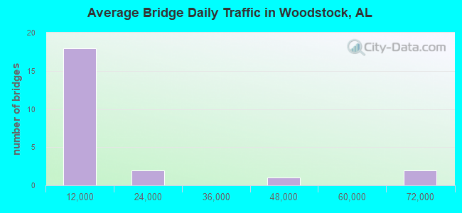
- 260,288Total average daily traffic
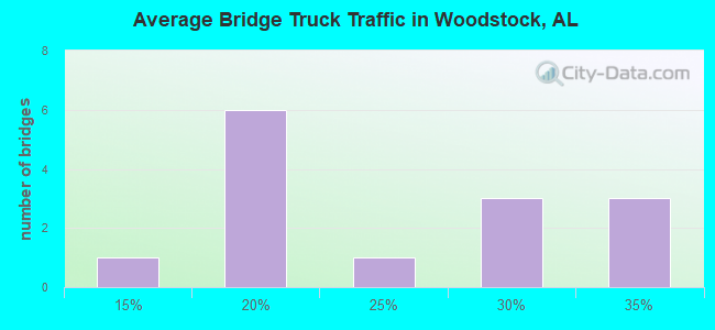
- 70,180Total average daily truck traffic
- National Bridge Inventory (NBI) Registered Bridges for Woodstock
- No street view available for this location
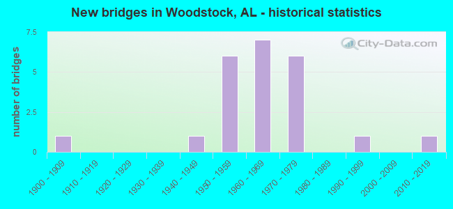
- New bridges - historical statistics
- 11900-1909
- 11940-1949
- 61950-1959
- 71960-1969
- 61970-1979
- 11990-1999
- 12010-2019
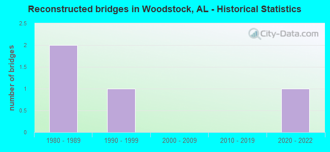
- Reconstructed bridges - Historical Statistics
- 21980-1989
- 11990-1999
- 02000-2009
- 02010-2019
- 12020-2022
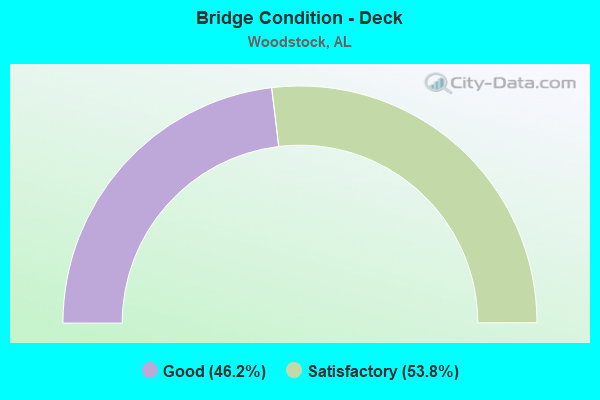
- Bridge Condition - Deck
- 46.2%Good
- 53.8%Satisfactory
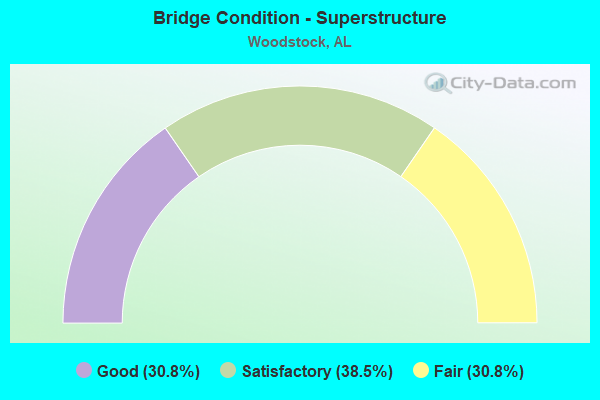
- Bridge Condition - Superstructure
- 30.8%Good
- 38.5%Satisfactory
- 30.8%Fair
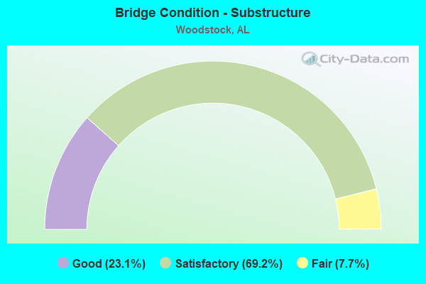
- Bridge Condition - Substructure
- 23.1%Good
- 69.2%Satisfactory
- 7.7%Fair
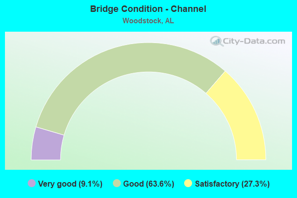
- Bridge Condition - Channel
- 9.1%Very good
- 63.6%Good
- 27.3%Satisfactory
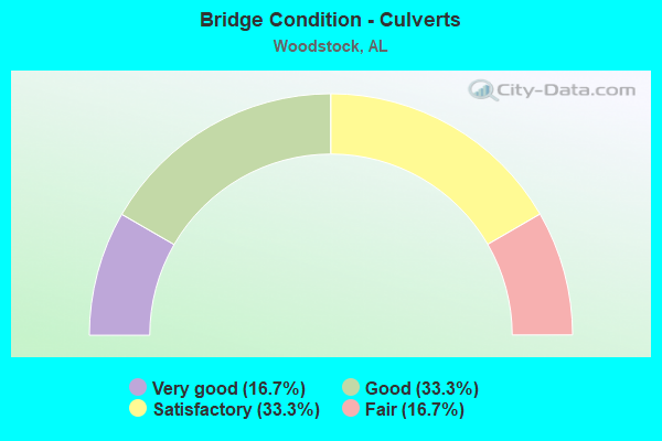
- Bridge Condition - Culverts
- 16.7%Very good
- 33.3%Good
- 33.3%Satisfactory
- 16.7%Fair
Find on map >> Show street view
Structure Number: 2199, Location: 0.9 MI NE OF JCT US NO 11 (Lat: 33.237647, Lng: -87.146697), Route carried "on" structure: County highway , Year Built: 1940, Status: Open, Structure Length: 1.86m (6.10ft), Average Daily Traffic: 20 (year 1997), Average Future Daily Traffic: 50 (year 2035), Design Load: H 15, Features Intersected: L*N SPUR LINE(ABANDONED), Facility Carried by Structure: GILES ROAD
Minimum Vertical Clearance: 30+ m (98+ ft), Kilometerpoint: 0.010, Lanes on structure: 2, Owner: County Highway Agency, Approaching Roadway Width: 7.3m (24.0ft), Material/Design: Concrete, Design/Construction: Tee Beam, Number Of Spans In Main Unit: 2, Length of Maximum Span: 10.1m (33.1ft), Curb-To-Curb Width: 6.1m (20.0ft), Out-to-Out Width: 6.7m (22.0ft)
Condition: Deck: Satisfactory, Superstructure: Good, Substructure: Satisfactory, Operating Rating: 60.4 metric tons, Method Used To Determine Operating Rating: Load Factor (LF), Inventory Rating: 36.2 metric tons, Method Used To Determine Inventory Rating: Load Factor (LF), Structural Evaluation: Equal to present minimum criteria, Deck Geometry: Somewhat better than minimum adequacy, Approach Roadway Alignment: Equal to present minimum criteria, Length Of Structure Improvement: 2.58m (8.46ft), Designated Inspection Frequency: Every 24 months, Inspection Date: August 2021, Bridge Improvement Cost: $389,000, Roadway Improvement Cost: $39,000, Total Project Cost: $428,000 ( Estimate for 2022), Deck Structure Type: Concrete Cast-file-Place, Wearing Surface/Protective System: Wearing Surface: Bituminous
Find on map >> Show street view
Structure Number: 3622, Location: TANNEHILL STATE PARK (Lat: 33.257222, Lng: -87.062500), Route carried "on" structure: State lands road , Year Built: 1902, Status: Posted for load, Structure Length: 4.30m (14.11ft), Average Daily Traffic: 70 (year 2021), Average Future Daily Traffic: 150 (year 2041), Design Load: H 10, Features Intersected: HALLS CREEK, Facility Carried by Structure: PARKS ROAD
Minimum Vertical Clearance: 4.44m (14.57ft), Kilometerpoint: 10.902, Lanes on structure: 1, Owner: State Park, Forest, or Reservation Agency, Maintenance Responsibility: State Highway Agency, Approaching Roadway Width: 4.3m (14.1ft), Material/Design: Steel, Design/Construction: Truss - Thru, Number Of Spans In Main Unit: 1, Number Of Approach Spans: 2, Length of Maximum Span: 24.4m (80.1ft), Curb-To-Curb Width: 4.0m (13.1ft), Out-to-Out Width: 4.9m (16.1ft)
Condition: Deck: Satisfactory, Superstructure: Fair, Substructure: Satisfactory, Channel: Good, Operating Rating: 9.2 metric tons, Method Used To Determine Operating Rating: Load Factor (LF), Inventory Rating: 5.5 metric tons, Method Used To Determine Inventory Rating: Load Factor (LF), Structural Evaluation: High priority of replacement, Deck Geometry: Somewhat better than minimum adequacy, Waterway Adequacy: Equal to present minimum criteria, Approach Roadway Alignment: Somewhat better than minimum adequacy, Bridge Posting: Required (Relationship of Operating Rating to Maximum Legal Load: > 39.9% below), Length Of Structure Improvement: 5.27m (17.29ft), Designated Inspection Frequency: Every 24 months, Critical Feature Inspection Frequency: Every 12 months, Other Special Inspection Frequency: Every 12 months, Inspection Date: November 2020, Critical Feature Inspection Date: November 2021, Other Special Inspection Date: November 2021, Bridge Improvement Cost: $579,000, Roadway Improvement Cost: $58,000, Total Project Cost: $637,000 ( Estimate for 2022), Deck Structure Type: Wood or Timber, Wearing Surface/Protective System: Wearing Surface: Wood or Timber
Find on map >> Show street view
Structure Number: 501, Location: 2.2 MI N CAFFEE JCT (Lat: 33.270050, Lng: -87.107131), Route carried "on" structure: Interstate 59, Year Built: 1955, Year Reconstructed: 2002, Status: Open, Structure Length: 0.91m (2.99ft), Average Daily Traffic: 62,647 (year 2020), Truck Traffic: 30%, Average Future Daily Traffic: 102,654 (year 2040), Design Load: H 20, Features Intersected: MUD CREEK
Minimum Vertical Clearance: 30+ m (98+ ft), Kilometerpoint: 159.887, Lanes on structure: 6, Base Highway Network: Yes, Owner: State Highway Agency, Approaching Roadway Width: 23.2m (76.1ft), Skew: 34 degrees, Material/Design: Concrete, Design/Construction: Culvert, Number Of Spans In Main Unit: 2, Length of Maximum Span: 4.3m (14.1ft)
Condition: Channel: Good, Culverts: Fair, Operating Rating: 58.3 metric tons, Method Used To Determine Operating Rating: Load Factor (LF), Inventory Rating: 34.9 metric tons, Method Used To Determine Inventory Rating: Load Factor (LF), Structural Evaluation: Somewhat better than minimum adequacy, Waterway Adequacy: Equal to present minimum criteria, Approach Roadway Alignment: Equal to present desirable criteria, Length Of Structure Improvement: 1.59m (5.22ft), Designated Inspection Frequency: Every 24 months, Inspection Date: June 2021, Bridge Improvement Cost: $2,747,000, Roadway Improvement Cost: $275,000, Total Project Cost: $3,022,000 ( Estimate for 2022)
Find on map >> Show street view
Structure Number: 5795, Location: 3.0 MI S OF WOODSTOCK (Lat: 33.163083, Lng: -87.152933), Route carried "on" structure: State highway 5, Year Built: 1957, Status: Open, Structure Length: 1.92m (6.30ft), Average Daily Traffic: 7,505 (year 2016), Truck Traffic: 16%, Average Future Daily Traffic: 9,396 (year 2042), Design Load: HS 20, Features Intersected: JOHNSONS BROOK
Minimum Vertical Clearance: 30+ m (98+ ft), Kilometerpoint: 163.635, Lanes on structure: 2, Base Highway Network: Yes, Owner: State Highway Agency, Approaching Roadway Width: 10.4m (34.1ft), Material/Design: Concrete, Design/Construction: Culvert, Number Of Spans In Main Unit: 5, Length of Maximum Span: 3.7m (12.1ft)
Condition: Channel: Good, Culverts: Satisfactory, Operating Rating: 64.0 metric tons, Method Used To Determine Operating Rating: Load Factor (LF), Inventory Rating: 38.3 metric tons, Method Used To Determine Inventory Rating: Load Factor (LF), Structural Evaluation: Equal to present minimum criteria, Waterway Adequacy: Equal to present minimum criteria, Approach Roadway Alignment: Equal to present desirable criteria, Length Of Structure Improvement: 2.65m (8.69ft), Designated Inspection Frequency: Every 24 months, Inspection Date: January 2022, Bridge Improvement Cost: $1,317,000, Roadway Improvement Cost: $132,000, Total Project Cost: $1,449,000 ( Estimate for 2022)
Find on map >> Show street view
Structure Number: 5796, Location: WOODSTOCK (Lat: 33.204300, Lng: -87.156217), Route carried "on" structure: State highway 5, Year Built: 1957, Status: Open, Structure Length: 6.34m (20.80ft), Average Daily Traffic: 7,400 (year 2013), Truck Traffic: 18%, Average Future Daily Traffic: 9,265 (year 2033), Design Load: H 20, Features Intersected: NORFOLK & SO RR Active
Minimum Vertical Clearance: 30+ m (98+ ft), Kilometerpoint: 168.304, Lanes on structure: 2, Base Highway Network: Yes, Owner: State Highway Agency, Approaching Roadway Width: 12.8m (42.0ft), Material/Design: Steel, Design/Construction: Stringer/Multi-beam, Number Of Spans In Main Unit: 1, Number Of Approach Spans: 4, Length of Maximum Span: 24.4m (80.1ft), Curb or Sidewalk Widths: Left: 0.2m (0.7ft), Right: 0.2m (0.7ft), Curb-To-Curb Width: 8.5m (27.9ft), Out-to-Out Width: 10.1m (33.1ft)
Condition: Deck: Satisfactory, Superstructure: Satisfactory, Substructure: Satisfactory, Operating Rating: 45.9 metric tons, Method Used To Determine Operating Rating: Load Factor (LF), Inventory Rating: 27.6 metric tons, Method Used To Determine Inventory Rating: Load Factor (LF), Structural Evaluation: Equal to present minimum criteria, Deck Geometry: Meets minimum limits, Underclear: Meets minimum limits, Approach Roadway Alignment: Equal to present desirable criteria, Length Of Structure Improvement: 7.38m (24.21ft), Designated Inspection Frequency: Every 24 months, Inspection Date: June 2020, Bridge Improvement Cost: $1,670,000, Roadway Improvement Cost: $167,000, Total Project Cost: $1,837,000 ( Estimate for 2022), Deck Structure Type: Concrete Cast-file-Place
Find on map >> Show street view
Structure Number: 5799, Location: CAFFEE JCT (Lat: 33.243300, Lng: -87.139300), Route carried "on" structure: Bypass US 11, Year Built: 1957, Status: Open, Structure Length: 5.85m (19.19ft), Average Daily Traffic: 5,250 (year 2013), Truck Traffic: 16%, Average Future Daily Traffic: 6,573 (year 2033), Design Load: HS 20, Features Intersected: L&N RR (ABANDONED)
Minimum Vertical Clearance: 30+ m (98+ ft), Kilometerpoint: 173.965, Lanes on structure: 2, Base Highway Network: Yes, Owner: State Highway Agency, Approaching Roadway Width: 8.4m (27.6ft), Skew: 13 degrees, Material/Design: Concrete, Design/Construction: Tee Beam, Number Of Spans In Main Unit: 5, Length of Maximum Span: 12.2m (40.0ft), Curb or Sidewalk Widths: Left: 1.2m (3.9ft), Right: 0.5m (1.6ft), Curb-To-Curb Width: 8.4m (27.6ft), Out-to-Out Width: 10.9m (35.8ft)
Condition: Deck: Satisfactory, Superstructure: Satisfactory, Substructure: Satisfactory, Operating Rating: 65.4 metric tons, Method Used To Determine Operating Rating: Load Factor (LF), Inventory Rating: 39.3 metric tons, Method Used To Determine Inventory Rating: Load Factor (LF), Structural Evaluation: Equal to present minimum criteria, Deck Geometry: High priority of corrective action, Approach Roadway Alignment: Equal to present desirable criteria, Length Of Structure Improvement: 6.89m (22.60ft), Designated Inspection Frequency: Every 24 months, Inspection Date: May 2020, Bridge Improvement Cost: $1,654,000, Roadway Improvement Cost: $165,000, Total Project Cost: $1,819,000 ( Estimate for 2022), Deck Structure Type: Concrete Cast-file-Place
Find on map >> Show street view
Structure Number: 58, Location: CAFFEE JCT (Lat: 33.243300, Lng: -87.139100), Route carried "on" structure: US 11, Year Built: 1957, Status: Open, Structure Length: 5.85m (19.19ft), Average Daily Traffic: 5,250 (year 2013), Truck Traffic: 16%, Average Future Daily Traffic: 6,573 (year 2033), Design Load: HS 20, Features Intersected: L&N RR (ABANDONED)
Minimum Vertical Clearance: 30+ m (98+ ft), Kilometerpoint: 173.965, Lanes on structure: 2, Base Highway Network: Yes, Owner: State Highway Agency, Approaching Roadway Width: 10.4m (34.1ft), Skew: 13 degrees, Material/Design: Concrete, Design/Construction: Tee Beam, Number Of Spans In Main Unit: 5, Length of Maximum Span: 12.2m (40.0ft), Curb or Sidewalk Widths: Left: 0.5m (1.6ft), Right: 1.2m (3.9ft), Curb-To-Curb Width: 8.4m (27.6ft), Out-to-Out Width: 10.9m (35.8ft)
Condition: Deck: Satisfactory, Superstructure: Satisfactory, Substructure: Satisfactory, Operating Rating: 65.4 metric tons, Method Used To Determine Operating Rating: Load Factor (LF), Inventory Rating: 39.3 metric tons, Method Used To Determine Inventory Rating: Load Factor (LF), Structural Evaluation: Equal to present minimum criteria, Deck Geometry: High priority of corrective action, Approach Roadway Alignment: Equal to present desirable criteria, Length Of Structure Improvement: 6.89m (22.60ft), Designated Inspection Frequency: Every 24 months, Inspection Date: May 2020, Bridge Improvement Cost: $1,654,000, Roadway Improvement Cost: $165,000, Total Project Cost: $1,819,000 ( Estimate for 2022), Deck Structure Type: Concrete Cast-file-Place
Find on map >> Show street view
Structure Number: 8161, Location: 2.0 MI S CAFFEE JCT (Lat: 33.233828, Lng: -87.162775), Route carried "on" structure: Interstate 59, Year Built: 1964, Year Reconstructed: 1993, Status: Open, Structure Length: 4.63m (15.19ft), Average Daily Traffic: 23,785 (year 2013), Truck Traffic: 32%, Average Future Daily Traffic: 29,427 (year 2033), Design Load: HS 20, Features Intersected: COUNTY ROAD, Facility Carried by Structure: I-20
Minimum Vertical Clearance: 30+ m (98+ ft), Kilometerpoint: 153.156, Lanes on structure: 2, Lanes under structure: 2, Base Highway Network: Yes, Owner: State Highway Agency, Approaching Roadway Width: 18.9m (62.0ft), Skew: 14 degrees, Material/Design: Concrete, Design/Construction: Tee Beam, Number Of Spans In Main Unit: 3, Length of Maximum Span: 15.2m (49.9ft), Curb-To-Curb Width: 18.3m (60.0ft), Out-to-Out Width: 19.2m (63.0ft)
Condition: Deck: Good, Superstructure: Good, Substructure: Good, Operating Rating: 37.8 metric tons, Method Used To Determine Operating Rating: Load Factor (LF), Inventory Rating: 22.8 metric tons, Method Used To Determine Inventory Rating: Load Factor (LF), Structural Evaluation: Somewhat better than minimum adequacy, Deck Geometry: Superior to present desirable criteria, Underclear: Somewhat better than minimum adequacy, Approach Roadway Alignment: Equal to present desirable criteria, Length Of Structure Improvement: 5.63m (18.47ft), Designated Inspection Frequency: Every 24 months, Inspection Date: October 2021, Bridge Improvement Cost: $2,433,000, Roadway Improvement Cost: $243,000, Total Project Cost: $2,676,000 ( Estimate for 2022), Deck Structure Type: Concrete Cast-file-Place, Wearing Surface/Protective System: Wearing Surface: Epoxy Overlay
Find on map >> Show street view
Structure Number: 8162, Location: 2.0 MI S CAFFEE JCT (Lat: 33.233989, Lng: -87.162825), Route carried "on" structure: Interstate 59, Year Built: 1964, Year Reconstructed: 1993, Status: Open, Structure Length: 4.63m (15.19ft), Average Daily Traffic: 23,785 (year 2013), Truck Traffic: 32%, Average Future Daily Traffic: 29,427 (year 2033), Design Load: HS 20, Features Intersected: COUNTY ROAD, Facility Carried by Structure: I-20
Minimum Vertical Clearance: 30+ m (98+ ft), Kilometerpoint: 153.156, Lanes on structure: 2, Lanes under structure: 2, Base Highway Network: Yes, Owner: State Highway Agency, Approaching Roadway Width: 18.9m (62.0ft), Skew: 14 degrees, Material/Design: Concrete, Design/Construction: Tee Beam, Number Of Spans In Main Unit: 3, Length of Maximum Span: 15.2m (49.9ft), Curb-To-Curb Width: 18.3m (60.0ft), Out-to-Out Width: 19.2m (63.0ft)
Condition: Deck: Good, Superstructure: Good, Substructure: Satisfactory, Operating Rating: 37.8 metric tons, Method Used To Determine Operating Rating: Load Factor (LF), Inventory Rating: 22.8 metric tons, Method Used To Determine Inventory Rating: Load Factor (LF), Structural Evaluation: Somewhat better than minimum adequacy, Deck Geometry: Superior to present desirable criteria, Underclear: Somewhat better than minimum adequacy, Approach Roadway Alignment: Equal to present desirable criteria, Length Of Structure Improvement: 5.63m (18.47ft), Designated Inspection Frequency: Every 24 months, Inspection Date: October 2021, Bridge Improvement Cost: $2,433,000, Roadway Improvement Cost: $243,000, Total Project Cost: $2,676,000 ( Estimate for 2022), Deck Structure Type: Concrete Cast-file-Place, Wearing Surface/Protective System: Wearing Surface: Epoxy Overlay
Find on map >> Show street view
Structure Number: 8669, Location: CAFFEE JUNCTION (Lat: 33.249600, Lng: -87.134850), Route carried "on" structure: US 11, Year Built: 1965, Status: Open, Structure Length: 10.67m (35.01ft), Average Daily Traffic: 11,230 (year 2013), Truck Traffic: 14%, Average Future Daily Traffic: 14,060 (year 2033), Design Load: HS 20, Features Intersected: I-59,I-20
Minimum Vertical Clearance: 30+ m (98+ ft), Kilometerpoint: 174.744, Lanes on structure: 2, Lanes under structure: 4, Base Highway Network: Yes, Owner: State Highway Agency, Approaching Roadway Width: 12.8m (42.0ft), Skew: 4 degrees, Material/Design: Concrete continuous, Design/Construction: Tee Beam, Number Of Spans In Main Unit: 4, Length of Maximum Span: 29.3m (96.1ft), Curb or Sidewalk Widths: Left: 0.4m (1.3ft), Right: 0.4m (1.3ft), Curb-To-Curb Width: 8.6m (28.2ft), Out-to-Out Width: 10.1m (33.1ft)
Condition: Deck: Good, Superstructure: Satisfactory, Substructure: Good, Operating Rating: 48.5 metric tons, Method Used To Determine Operating Rating: Load Factor (LF), Inventory Rating: 29.2 metric tons, Method Used To Determine Inventory Rating: Load Factor (LF), Structural Evaluation: Equal to present minimum criteria, Deck Geometry: Meets minimum limits, Underclear: Equal to present minimum criteria, Approach Roadway Alignment: Equal to present desirable criteria, Length Of Structure Improvement: 11.57m (37.96ft), Designated Inspection Frequency: Every 24 months, Inspection Date: August 2020, Bridge Improvement Cost: $2,618,000, Roadway Improvement Cost: $262,000, Total Project Cost: $2,880,000 ( Estimate for 2022), Deck Structure Type: Concrete Cast-file-Place
Find on map >> Show street view
Structure Number: 10258, Location: TANNEHIL STATE PARK (Lat: 33.257306, Lng: -87.062672), Route carried "on" structure: State lands road , Year Built: 1970, Status: Open, Structure Length: 0.91m (2.99ft), Average Daily Traffic: 90 (year 2021), Average Future Daily Traffic: 150 (year 2041), Design Load: H 15, Features Intersected: HALLS CREEK, Facility Carried by Structure: PARK ROAD
Minimum Vertical Clearance: 7.56m (24.80ft), Kilometerpoint: 10.900, Lanes on structure: 1, Owner: State Highway Agency, Approaching Roadway Width: 4.9m (16.1ft), Skew: 2 degrees, Material/Design: Concrete, Design/Construction: Culvert, Number Of Spans In Main Unit: 11, Length of Maximum Span: 0.6m (2.0ft), Curb-To-Curb Width: 4.6m (15.1ft), Out-to-Out Width: 4.9m (16.1ft)
Condition: Channel: Good, Culverts: Good, Operating Rating: 43.5 metric tons, Method Used To Determine Operating Rating: Field evaluation and documented engineering judgment, Inventory Rating: 32.7 metric tons, Method Used To Determine Inventory Rating: Field evaluation and documented engineering judgment, Structural Evaluation: Better than present minimum criteria, Deck Geometry: Better than present minimum criteria, Waterway Adequacy: Equal to present desirable criteria, Approach Roadway Alignment: Equal to present desirable criteria, Length Of Structure Improvement: 1.59m (5.22ft), Designated Inspection Frequency: Every 24 months, Inspection Date: January 2021, Bridge Improvement Cost: $146,000, Roadway Improvement Cost: $15,000, Total Project Cost: $161,000 ( Estimate for 2022), Deck Structure Type: Concrete Cast-file-Place
Find on map >> Show street view
Structure Number: 10267, Location: TANNEHILL STATE PARK (Lat: 33.251400, Lng: -87.067333), Route carried "on" structure: State lands road 2796, Year Built: 1970, Year Reconstructed: 2020, Status: Posted for load, Structure Length: 2.32m (7.61ft), Average Daily Traffic: 40 (year 2015), Average Future Daily Traffic: 60 (year 2039), Features Intersected: MILL CREEK
Minimum Vertical Clearance: 30+ m (98+ ft), Kilometerpoint: 0.079, Lanes on structure: 1, Owner: State Park, Forest, or Reservation Agency, Approaching Roadway Width: 3.4m (11.2ft), Material/Design: Steel, Design/Construction: Stringer/Multi-beam, Number Of Spans In Main Unit: 1, Length of Maximum Span: 23.2m (76.1ft), Curb or Sidewalk Widths: Left: 0.2m (0.7ft), Right: 0.2m (0.7ft), Curb-To-Curb Width: 4.6m (15.1ft), Out-to-Out Width: 4.9m (16.1ft)
Condition: Deck: Good, Superstructure: Fair, Substructure: Satisfactory, Channel: Good, Operating Rating: 9.9 metric tons, Method Used To Determine Operating Rating: Load Factor (LF), Inventory Rating: 6.5 metric tons, Method Used To Determine Inventory Rating: Load Factor (LF), Structural Evaluation: High priority of replacement, Deck Geometry: Better than present minimum criteria, Waterway Adequacy: Better than present minimum criteria, Approach Roadway Alignment: Equal to present desirable criteria, Bridge Posting: Required (Relationship of Operating Rating to Maximum Legal Load: > 39.9% below), Length Of Structure Improvement: 3.15m (10.33ft), Designated Inspection Frequency: Every 24 months, Other Special Inspection Frequency: Every 12 months, Inspection Date: Febuary 2022, Other Special Inspection Date: Febuary 2022, Bridge Improvement Cost: $346,000, Roadway Improvement Cost: $35,000, Total Project Cost: $381,000 ( Estimate for 2022), Deck Structure Type: Wood or Timber, Wearing Surface/Protective System: Wearing Surface: Wood or Timber
Find on map >> Show street view
Structure Number: 10439, Location: 1.8 MI SE OF JCT ALA 216 (Lat: 33.256650, Lng: -87.078697), Route carried "on" structure: County highway 390, Year Built: 1970, Status: Open, Structure Length: 1.28m (4.20ft), Average Daily Traffic: 800 (year 2002), Average Future Daily Traffic: 1,000 (year 2035), Design Load: HS 20, Features Intersected: MUD CREEK, Facility Carried by Structure: EASTERN VALLEY RD.
Minimum Vertical Clearance: 30+ m (98+ ft), Kilometerpoint: 0.010, Lanes on structure: 2, Owner: County Highway Agency, Approaching Roadway Width: 8.5m (27.9ft), Material/Design: Concrete, Design/Construction: Culvert, Number Of Spans In Main Unit: 4, Length of Maximum Span: 3.0m (9.8ft), Out-to-Out Width: 21.3m (69.9ft)
Condition: Channel: Good, Culverts: Good, Operating Rating: 88.9 metric tons, Method Used To Determine Operating Rating: Load Factor (LF), Inventory Rating: 65.1 metric tons, Method Used To Determine Inventory Rating: Load Factor (LF), Structural Evaluation: Better than present minimum criteria, Waterway Adequacy: Better than present minimum criteria, Approach Roadway Alignment: Equal to present desirable criteria, Length Of Structure Improvement: 1.95m (6.40ft), Designated Inspection Frequency: Every 24 months, Inspection Date: June 2021, Bridge Improvement Cost: $756,000, Roadway Improvement Cost: $76,000, Total Project Cost: $832,000 ( Estimate for 2022), Wearing Surface/Protective System: Wearing Surface: Bituminous
Find on map >> Show street view
Structure Number: 11368, Location: .5 MI W OLD TUSC HWY (Lat: 33.283147, Lng: -87.086078), Route carried "on" structure: County highway , Year Built: 1975, Status: Open, Structure Length: 1.12m (3.67ft), Average Daily Traffic: 46 (year 2021), Average Future Daily Traffic: 65 (year 2041), Features Intersected: TINGLE CREEK, Facility Carried by Structure: TINGLE SPRINGS RD
Minimum Vertical Clearance: 30+ m (98+ ft), Kilometerpoint: 0.000, Lanes on structure: 1, Owner: County Highway Agency, Approaching Roadway Width: 3.6m (11.8ft), Material/Design: Steel, Design/Construction: Stringer/Multi-beam, Number Of Spans In Main Unit: 3, Length of Maximum Span: 3.1m (10.2ft), Curb-To-Curb Width: 4.9m (16.1ft), Out-to-Out Width: 5.2m (17.1ft)
Condition: Deck: Satisfactory, Superstructure: Fair, Substructure: Satisfactory, Channel: Satisfactory, Operating Rating: 37.2 metric tons, Method Used To Determine Operating Rating: Load Factor (LF), Inventory Rating: 22.2 metric tons, Method Used To Determine Inventory Rating: Load Factor (LF), Structural Evaluation: Somewhat better than minimum adequacy, Deck Geometry: High priority of corrective action, Waterway Adequacy: Equal to present minimum criteria, Approach Roadway Alignment: Somewhat better than minimum adequacy, Length Of Structure Improvement: 1.79m (5.87ft), Designated Inspection Frequency: Every 24 months, Underwater Inspection Frequency: Every 48 months, Inspection Date: August 2021, Underwater Inspection Date: July 2018, Bridge Improvement Cost: $209,000, Roadway Improvement Cost: $21,000, Total Project Cost: $230,000 ( Estimate for 2022), Deck Structure Type: Open Grating
Find on map >> Show street view
Structure Number: 11622, Location: GREENPOND (Lat: 33.225403, Lng: -87.127075), Route carried "on" structure: County highway 15, Year Built: 1976, Status: Open, Structure Length: 5.12m (16.80ft), Average Daily Traffic: 455 (year 1987), Truck Traffic: 20%, Average Future Daily Traffic: 685 (year 2030), Design Load: HS 20, Features Intersected: VIADUCT OVER SO RR
Minimum Vertical Clearance: 30+ m (98+ ft), Kilometerpoint: 0.010, Lanes on structure: 2, Owner: County Highway Agency, Approaching Roadway Width: 9.1m (29.9ft), Material/Design: Steel, Design/Construction: Stringer/Multi-beam, Number Of Spans In Main Unit: 2, Number Of Approach Spans: 2, Length of Maximum Span: 15.2m (49.9ft), Curb-To-Curb Width: 8.5m (27.9ft), Out-to-Out Width: 9.4m (30.8ft)
Condition: Deck: Good, Superstructure: Good, Substructure: Good, Operating Rating: 44.4 metric tons, Method Used To Determine Operating Rating: Load Factor (LF), Inventory Rating: 26.6 metric tons, Method Used To Determine Inventory Rating: Load Factor (LF), Structural Evaluation: Equal to present minimum criteria, Deck Geometry: Somewhat better than minimum adequacy, Underclear: Superior to present desirable criteria, Approach Roadway Alignment: Equal to present minimum criteria, Length Of Structure Improvement: 6.14m (20.14ft), Designated Inspection Frequency: Every 24 months, Inspection Date: November 2020, Bridge Improvement Cost: $1,264,000, Roadway Improvement Cost: $126,000, Total Project Cost: $1,390,000 ( Estimate for 2022), Deck Structure Type: Concrete Cast-file-Place
Find on map >> Show street view
Structure Number: 15787, Location: .12 MI S TINGLE SPRGS RD (Lat: 33.282167, Lng: -87.080381), Route carried "on" structure: County highway 447, Year Built: 1950, Status: Open, Structure Length: 0.95m (3.12ft), Average Daily Traffic: 3,855 (year 2018), Truck Traffic: 25%, Average Future Daily Traffic: 5,375 (year 2038), Design Load: HS 20, Features Intersected: COOLEY CREEK, Facility Carried by Structure: OLD TUSCALOOSA HWY
Minimum Vertical Clearance: 30+ m (98+ ft), Kilometerpoint: 0.000, Lanes on structure: 2, Owner: County Highway Agency, Approaching Roadway Width: 8.1m (26.6ft), Material/Design: Concrete continuous, Design/Construction: Culvert, Number Of Spans In Main Unit: 3, Length of Maximum Span: 3.0m (9.8ft)
Condition: Channel: Satisfactory, Culverts: Satisfactory, Operating Rating: 61.9 metric tons, Method Used To Determine Operating Rating: Load Factor (LF), Inventory Rating: 37.0 metric tons, Method Used To Determine Inventory Rating: Load Factor (LF), Structural Evaluation: Equal to present minimum criteria, Waterway Adequacy: Equal to present minimum criteria, Approach Roadway Alignment: Better than present minimum criteria, Length Of Structure Improvement: 1.63m (5.35ft), Designated Inspection Frequency: Every 24 months, Inspection Date: November 2020, Bridge Improvement Cost: $601,000, Roadway Improvement Cost: $60,000, Total Project Cost: $661,000 ( Estimate for 2022)
Find on map >> Show street view
Structure Number: 16233, Location: TANNEHILL STATE PARK (Lat: 33.251367, Lng: -87.069183), Route carried "on" structure: State lands road 6208, Year Built: 1995, Status: Open, Structure Length: 1.46m (4.79ft), Average Daily Traffic: 40 (year 2013), Average Future Daily Traffic: 60 (year 2039), Design Load: HS 20, Features Intersected: MUD CREEK
Minimum Vertical Clearance: 30+ m (98+ ft), Kilometerpoint: 0.039, Lanes on structure: 2, Owner: State Park, Forest, or Reservation Agency, Approaching Roadway Width: 7.9m (25.9ft), Material/Design: Concrete, Design/Construction: Channel Beam, Number Of Spans In Main Unit: 2, Length of Maximum Span: 7.3m (24.0ft), Curb or Sidewalk Widths: Left: 0.0m, Right: 1.8m (5.9ft), Curb-To-Curb Width: 7.6m (24.9ft), Out-to-Out Width: 10.4m (34.1ft)
Condition: Deck: Good, Superstructure: Satisfactory, Substructure: Satisfactory, Channel: Good, Operating Rating: 52.8 metric tons, Method Used To Determine Operating Rating: Load Factor (LF), Inventory Rating: 31.7 metric tons, Method Used To Determine Inventory Rating: Load Factor (LF), Structural Evaluation: Equal to present minimum criteria, Deck Geometry: Equal to present minimum criteria, Waterway Adequacy: Equal to present minimum criteria, Approach Roadway Alignment: Better than present minimum criteria, Length Of Structure Improvement: 2.14m (7.02ft), Designated Inspection Frequency: Every 24 months, Inspection Date: Febuary 2022, Bridge Improvement Cost: $499,000, Roadway Improvement Cost: $50,000, Total Project Cost: $549,000 ( Estimate for 2022), Deck Structure Type: Concrete Precast Panels
Find on map >> Show street view
Structure Number: 20346, Location: 2.7 MI NE OF JCT ALA 216 (Lat: 33.266842, Lng: -87.066392), Route carried "on" structure: County highway 390, Year Built: 2010, Status: Open, Structure Length: 1.40m (4.59ft), Average Daily Traffic: 800 (year 2010), Average Future Daily Traffic: 800 (year 2035), Design Load: HS 20, Features Intersected: COOLEY CREEK, Facility Carried by Structure: EASTERN VALLEY RD
Minimum Vertical Clearance: 30+ m (98+ ft), Kilometerpoint: 0.010, Lanes on structure: 2, Owner: County Highway Agency, Approaching Roadway Width: 12.2m (40.0ft), Material/Design: Concrete, Design/Construction: Culvert, Number Of Spans In Main Unit: 3, Length of Maximum Span: 4.3m (14.1ft)
Condition: Channel: Very good, Culverts: Very good, Operating Rating: 42.8 metric tons, Method Used To Determine Operating Rating: Load Factor (LF), Inventory Rating: 25.7 metric tons, Method Used To Determine Inventory Rating: Load Factor (LF), Structural Evaluation: Equal to present minimum criteria, Waterway Adequacy: Superior to present desirable criteria, Approach Roadway Alignment: Equal to present desirable criteria, Length Of Structure Improvement: 2.08m (6.82ft), Designated Inspection Frequency: Every 24 months, Inspection Date: May 2021, Bridge Improvement Cost: $840,000, Roadway Improvement Cost: $84,000, Total Project Cost: $924,000 ( Estimate for 2022)
Find on map >> Show street view
Structure Number: 20751, Location: TANNEHILL STATE PARK (Lat: 33.258672, Lng: -87.059172), Route carried "on" structure: State lands road , Year Built: 1975, Status: Closed, Structure Length: 1.23m (4.04ft), Average Daily Traffic: 70 (year 2021), Average Future Daily Traffic: 150 (year 2041), Features Intersected: HALLS CREEK, Facility Carried by Structure: PARKS ROAD
Minimum Vertical Clearance: 30+ m (98+ ft), Kilometerpoint: 0.000, Lanes on structure: 2, Owner: State Park, Forest, or Reservation Agency, Maintenance Responsibility: State Highway Agency, Approaching Roadway Width: 7.3m (24.0ft), Material/Design: Steel, Design/Construction: Stringer/Multi-beam, Number Of Spans In Main Unit: 1, Length of Maximum Span: 12.3m (40.4ft), Curb-To-Curb Width: 7.3m (24.0ft), Out-to-Out Width: 7.6m (24.9ft)
Condition: Deck: Satisfactory, Superstructure: Fair, Substructure: Fair, Channel: Satisfactory, Operating Rating: 10.6 metric tons, Method Used To Determine Operating Rating: Load Factor (LF), Inventory Rating: 6.4 metric tons, Method Used To Determine Inventory Rating: Load Factor (LF), Deck Geometry: Equal to present minimum criteria, Waterway Adequacy: Better than present minimum criteria, Approach Roadway Alignment: Better than present minimum criteria, Bridge Posting: Required (Relationship of Operating Rating to Maximum Legal Load: > 39.9% below), Length Of Structure Improvement: 1.91m (6.27ft), Designated Inspection Frequency: Every 24 months, Other Special Inspection Frequency: Every 12 months, Inspection Date: July 2019, Other Special Inspection Date: July 2021, Bridge Improvement Cost: $327,000, Roadway Improvement Cost: $33,000, Total Project Cost: $360,000 ( Estimate for 2022), Deck Structure Type: Wood or Timber, Wearing Surface/Protective System: Wearing Surface: Wood or Timber
Find on map >> Show street view
Structure Number: 8161, Location: 2.0 MI S CAFFEE JCT (Lat: 33.233828, Lng: -87.162775), Route carried "under" structure: County highway , Year Built: 1964, Structure Length: 0. m, Average Daily Traffic: 265 (year 2006), Truck Traffic: 15%, Features Intersected: COUNTY ROAD, Facility Carried by Structure: I-20
Minimum Vertical Clearance: 5.00m (16.40ft), Kilometerpoint: 0.000, Lanes on structure: 2, Lanes under structure: 2, Material/Design: Concrete, Design/Construction: Tee Beam, Length of Maximum Span: 15.2m (49.9ft)
Find on map >> Show street view
Structure Number: 8162, Location: 2.0 MI S CAFFEE JCT (Lat: 33.233989, Lng: -87.162825), Route carried "under" structure: County highway , Year Built: 1964, Structure Length: 0. m, Average Daily Traffic: 265 (year 2005), Truck Traffic: 15%, Features Intersected: COUNTY ROAD, Facility Carried by Structure: I-20
Minimum Vertical Clearance: 5.00m (16.40ft), Kilometerpoint: 0.000, Lanes on structure: 2, Lanes under structure: 2, Material/Design: Concrete, Design/Construction: Tee Beam, Length of Maximum Span: 15.2m (49.9ft)
Find on map >> Show street view
Structure Number: 8669, Location: CAFFEE JUNCTION (Lat: 33.249600, Lng: -87.134850), Route carried "under" structure: Interstate 20, Year Built: 1965, Structure Length: 0. m, Average Daily Traffic: 46,130 (year 2013), Truck Traffic: 28%, Features Intersected: I-59,I-20, Facility Carried by Structure: US 11
Minimum Vertical Clearance: 5.40m (17.72ft), Kilometerpoint: 156.324, Lanes on structure: 2, Lanes under structure: 4, Material/Design: Concrete continuous, Design/Construction: Tee Beam, Length of Maximum Span: 29.3m (96.1ft)
Find on map >> Show street view
Structure Number: 8904, Location: OVER I59 3.2 MI E US11 (Lat: 33.279533, Lng: -87.095467), Route carried "under" structure: Interstate 20, Year Built: 1965, Structure Length: 0. m, Average Daily Traffic: 60,490 (year 2013), Truck Traffic: 27%, Features Intersected: I-59,I-20,US-11,SR-5, Facility Carried by Structure: SR 216
Minimum Vertical Clearance: 5.30m (17.39ft), Kilometerpoint: 161.395, Lanes on structure: 2, Lanes under structure: 4, Material/Design: Concrete continuous, Design/Construction: Tee Beam, Length of Maximum Span: 21.9m (71.9ft)