Bridge Statistics for Yorktown, New York (NY)
Condition, Traffic, Stress, Structural Evaluation, Project Costs
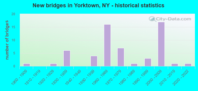
- New bridges - historical statistics
- 11900-1909
- 11920-1929
- 61930-1939
- 41950-1959
- 161960-1969
- 71970-1979
- 11980-1989
- 31990-1999
- 172000-2009
- 12010-2019
- 12020-2022
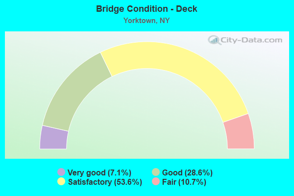
- Bridge Condition - Deck
- 7.1%Very good
- 28.6%Good
- 53.6%Satisfactory
- 10.7%Fair
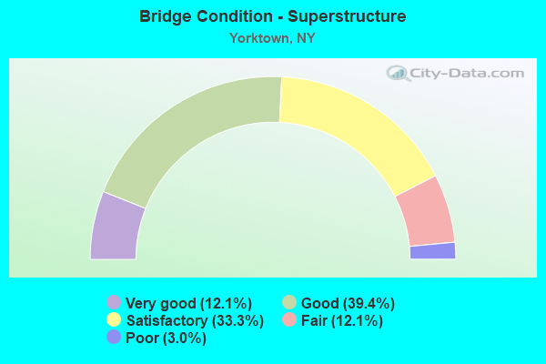
- Bridge Condition - Superstructure
- 12.1%Very good
- 39.4%Good
- 33.3%Satisfactory
- 12.1%Fair
- 3.0%Poor
- Bridge Condition - Substructure
- 6.1%Very good
- 39.4%Good
- 39.4%Satisfactory
- 12.1%Fair
- 3.0%Poor
- Bridge Condition - Channel
- 26.3%Very good
- 10.5%Good
- 47.4%Satisfactory
- 15.8%Fair
- Bridge Condition - Culverts
- 25.0%Excellent
- 25.0%Good
- 50.0%Satisfactory
Find on map >> Show street view
Structure Number: 100343, Location: 0.3 MI W JCT US 6 + TSP (Lat: 41.331492, Lng: -73.823453), Route carried "on" structure: US 6, Year Built: 1963, Status: Open, Structure Length: 1.52m (4.99ft), Average Daily Traffic: 17,488 (year 2015), Truck Traffic: 5%, Average Future Daily Traffic: 17,570 (year 2040), Design Load: H 20, Features Intersected: SHRUB OAK BROOK
Minimum Vertical Clearance: 30+ m (98+ ft), Kilometerpoint: 17.989, Lanes on structure: 4, Base Highway Network: Yes, Owner: State Highway Agency, Approaching Roadway Width: 25.0m (82.0ft), Skew: 30 degrees, Material/Design: Concrete continuous, Design/Construction: Culvert, Number Of Spans In Main Unit: 3, Length of Maximum Span: 4.5m (14.8ft)
Condition: Channel: Satisfactory, Culverts: Satisfactory, Operating Rating: 80.7 metric tons, Method Used To Determine Operating Rating: Load Factor (LF), Inventory Rating: 48.1 metric tons, Method Used To Determine Inventory Rating: Load Factor (LF), Structural Evaluation: Equal to present minimum criteria, Waterway Adequacy: Somewhat better than minimum adequacy, Approach Roadway Alignment: Equal to present desirable criteria, Length Of Structure Improvement: 1.52m (4.99ft), Designated Inspection Frequency: Every 24 months, Inspection Date: July 2020, Bridge Improvement Cost: $1,307,000, Roadway Improvement Cost: $766,000, Total Project Cost: $2,073,000 ( Estimate for 2021), Wearing Surface/Protective System: Wearing Surface: Bituminous
Find on map >> Show street view
Structure Number: 102339, Location: 0.8 MI W JCT RTE 202+TSP (Lat: 41.290786, Lng: -73.834683), Route carried "on" structure: State highway 35, Year Built: 2014, Status: Open, Structure Length: 0.76m (2.49ft), Average Daily Traffic: 19,125 (year 2016), Truck Traffic: 3%, Average Future Daily Traffic: 19,214 (year 2040), Design Load: HL 93, Features Intersected: HUNTER BROOK
Minimum Vertical Clearance: 30+ m (98+ ft), Kilometerpoint: 15.961, Lanes on structure: 4, Base Highway Network: Yes, Owner: State Highway Agency, Approaching Roadway Width: 18.3m (60.0ft), Skew: 21 degrees, Material/Design: Concrete, Design/Construction: Culvert, Number Of Spans In Main Unit: 1, Length of Maximum Span: 7.0m (23.0ft), Curb or Sidewalk Widths: Left: 0.0m, Right: 1.5m (4.9ft), Curb-To-Curb Width: 18.3m (60.0ft), Out-to-Out Width: 33.5m (109.9ft)
Condition: Channel: Satisfactory, Culverts: Good, Operating Rating: 88.1 metric tons, Method Used To Determine Operating Rating: Load and Resistance Factor Rating (LRFR) rating reported by rating factor(RF) method using HL-93 loadings, Inventory Rating: 68.0 metric tons, Method Used To Determine Inventory Rating: Load and Resistance Factor Rating (LRFR) rating reported by rating factor(RF) method using HL-93 loadings, Structural Evaluation: Better than present minimum criteria, Deck Geometry: Somewhat better than minimum adequacy, Waterway Adequacy: Meets minimum limits, Approach Roadway Alignment: Equal to present desirable criteria, Length Of Structure Improvement: 0.76m (2.49ft), Designated Inspection Frequency: Every 24 months, Inspection Date: April 2020, Bridge Improvement Cost: $720,000, Roadway Improvement Cost: $421,000, Total Project Cost: $1,141,000 ( Estimate for 2021), Wearing Surface/Protective System: Wearing Surface: Bituminous, Membrane: Other
Find on map >> Show street view
Structure Number: 103614, Location: .2 MI S.JCT RTS 100 & 118 (Lat: 41.227917, Lng: -73.765817), Route carried "on" structure: State highway 100, Year Built: 1989, Status: Open, Structure Length: 18.44m (60.50ft), Average Daily Traffic: 7,424 (year 2011), Truck Traffic: 4%, Average Future Daily Traffic: 9,018 (year 2040), Design Load: HS 20, Features Intersected: NEW CROTON RESVOR
Minimum Vertical Clearance: 30+ m (98+ ft), Kilometerpoint: 39.903, Lanes on structure: 2, Base Highway Network: Yes, Owner: State Highway Agency, Approaching Roadway Width: 15.8m (51.8ft), Skew: 20 degrees, Material/Design: Steel continuous, Design/Construction: Stringer/Multi-beam, Number Of Spans In Main Unit: 3, Length of Maximum Span: 70.1m (230.0ft), Curb-To-Curb Width: 15.8m (51.8ft), Out-to-Out Width: 16.5m (54.1ft)
Condition: Deck: Satisfactory, Superstructure: Good, Substructure: Good, Channel: Very good, Inventory Rating: 72.6 metric tons, Method Used To Determine Inventory Rating: Load Factor (LF), Structural Evaluation: Better than present minimum criteria, Deck Geometry: Superior to present desirable criteria, Waterway Adequacy: Equal to present minimum criteria, Approach Roadway Alignment: Equal to present desirable criteria, Length Of Structure Improvement: 18.44m (60.50ft), Designated Inspection Frequency: Every 24 months, Underwater Inspection Frequency: Every 60 months, Inspection Date: June 2021, Underwater Inspection Date: July 2020, Bridge Improvement Cost: $11,176,000, Roadway Improvement Cost: $6,544,000, Total Project Cost: $17,720,000 ( Estimate for 2021), Deck Structure Type: Concrete Cast-file-Place, Wearing Surface/Protective System: Wearing Surface: Integral Concrete, Deck Protection: Epoxy Coated Reinforcing
Find on map >> Show street view
Structure Number: 103758, Location: 2 MI W JCT SH100 & SH118 (Lat: 41.237683, Lng: -73.844294), Route carried "on" structure: State highway 129, Year Built: 1990, Status: Open, Structure Length: 26.27m (86.19ft), Average Daily Traffic: 6,627 (year 2015), Truck Traffic: 4%, Average Future Daily Traffic: 8,050 (year 2040), Design Load: HS 20, Features Intersected: CROTON LAKE RESER
Minimum Vertical Clearance: 30+ m (98+ ft), Kilometerpoint: 6.259, Lanes on structure: 2, Base Highway Network: Yes, Owner: State Highway Agency, Approaching Roadway Width: 11.0m (36.1ft), Material/Design: Steel continuous, Design/Construction: Stringer/Multi-beam, Number Of Spans In Main Unit: 4, Length of Maximum Span: 73.1m (239.8ft), Curb-To-Curb Width: 11.0m (36.1ft), Out-to-Out Width: 11.6m (38.1ft)
Condition: Deck: Satisfactory, Superstructure: Satisfactory, Substructure: Good, Channel: Very good, Inventory Rating: 77.1 metric tons, Method Used To Determine Inventory Rating: Load Factor (LF), Structural Evaluation: Equal to present minimum criteria, Deck Geometry: Meets minimum limits, Waterway Adequacy: Equal to present minimum criteria, Approach Roadway Alignment: Equal to present desirable criteria, Length Of Structure Improvement: 26.27m (86.19ft), Designated Inspection Frequency: Every 24 months, Underwater Inspection Frequency: Every 60 months, Inspection Date: June 2021, Underwater Inspection Date: November 2017, Bridge Improvement Cost: $11,269,000, Roadway Improvement Cost: $6,599,000, Total Project Cost: $17,869,000 ( Estimate for 2021), Deck Structure Type: Concrete Cast-file-Place, Wearing Surface/Protective System: Wearing Surface: Integral Concrete, Deck Protection: Epoxy Coated Reinforcing
Find on map >> Show street view
Structure Number: 103771, Location: 0.4 MI S JCT RTE 6+TSP (Lat: 41.327583, Lng: -73.819681), Route carried "on" structure: State highway 132, Year Built: 2007, Status: Open, Structure Length: 3.84m (12.60ft), Average Daily Traffic: 5,163 (year 2019), Truck Traffic: 6%, Average Future Daily Traffic: 6,272 (year 2040), Design Load: HS 25 or greater, Features Intersected: 987G987G87011163 SB, RTE
Minimum Vertical Clearance: 30+ m (98+ ft), Kilometerpoint: 3.958, Lanes on structure: 3, Lanes under structure: 6, Base Highway Network: Yes, Owner: State Highway Agency, Approaching Roadway Width: 14.9m (48.9ft), Skew: 2 degrees, Material/Design: Prestressed concrete, Design/Construction: Box Beam or Girders - Multiple, Number Of Spans In Main Unit: 2, Length of Maximum Span: 18.0m (59.1ft), Curb-To-Curb Width: 14.4m (47.2ft), Out-to-Out Width: 16.7m (54.8ft)
Condition: Deck: Satisfactory, Superstructure: Good, Substructure: Satisfactory, Operating Rating: 59.6 metric tons, Method Used To Determine Operating Rating: Load and Resistance Factor Rating (LRFR) rating reported by rating factor(RF) method using HL-93 loadings, Inventory Rating: 46.0 metric tons, Method Used To Determine Inventory Rating: Load and Resistance Factor Rating (LRFR) rating reported by rating factor(RF) method using HL-93 loadings, Structural Evaluation: Equal to present minimum criteria, Deck Geometry: Somewhat better than minimum adequacy, Underclear: Meets minimum limits, Approach Roadway Alignment: Equal to present desirable criteria, Length Of Structure Improvement: 3.84m (12.60ft), Designated Inspection Frequency: Every 24 months, Inspection Date: March 2021, Bridge Improvement Cost: $2,494,000, Roadway Improvement Cost: $1,461,000, Total Project Cost: $3,955,000 ( Estimate for 2021), Deck Structure Type: Concrete Cast-file-Place, Wearing Surface/Protective System: Wearing Surface: Integral Concrete, Deck Protection: Galvanized Reinforcing
Find on map >> Show street view
Structure Number: 103772, Location: 0.2MI W TSP+0.1MI S RTEG (Lat: 41.329603, Lng: -73.821014), Route carried "on" structure: State highway 132, Year Built: 1923, Status: Posted for load-capacity, Structure Length: 0.76m (2.49ft), Average Daily Traffic: 5,030 (year 2014), Truck Traffic: 4%, Average Future Daily Traffic: 6,110 (year 2040), Features Intersected: SHRUB OAK BROOK
Minimum Vertical Clearance: 30+ m (98+ ft), Kilometerpoint: 4.232, Lanes on structure: 2, Base Highway Network: Yes, Owner: State Highway Agency, Approaching Roadway Width: 6.7m (22.0ft), Skew: 1 degrees, Material/Design: Concrete, Design/Construction: Slab, Number Of Spans In Main Unit: 1, Length of Maximum Span: 7.3m (24.0ft), Curb-To-Curb Width: 8.0m (26.2ft), Out-to-Out Width: 8.6m (28.2ft)
Condition: Deck: Good, Superstructure: Good, Substructure: Satisfactory, Channel: Fair, Operating Rating: 22.0 metric tons, Method Used To Determine Operating Rating: Load and Resistance Factor Rating (LRFR) rating reported by rating factor(RF) method using HL-93 loadings, Inventory Rating: 16.8 metric tons, Method Used To Determine Inventory Rating: Load and Resistance Factor Rating (LRFR) rating reported by rating factor(RF) method using HL-93 loadings, Structural Evaluation: Meets minimum limits, Deck Geometry: High priority of replacement, Waterway Adequacy: Equal to present desirable criteria, Approach Roadway Alignment: Meets minimum limits, Length Of Structure Improvement: 0.76m (2.49ft), Designated Inspection Frequency: Every 24 months, Inspection Date: April 2020, Bridge Improvement Cost: $259,000, Roadway Improvement Cost: $152,000, Total Project Cost: $411,000 ( Estimate for 2021), Wearing Surface/Protective System: Wearing Surface: Bituminous
Find on map >> Show street view
Structure Number: 1037771, Location: JCT TSP & RTE 134 (Lat: 41.214411, Lng: -73.810522), Route carried "on" structure: Other road 987G, Year Built: 1968, Status: Open, Structure Length: 1.65m (5.41ft), Truck Traffic: 2%, Design Load: HS 20, Features Intersected: RTE 134
Minimum Vertical Clearance: 30+ m (98+ ft), Kilometerpoint: 17.747, Lanes on structure: 3, Lanes under structure: 2, Base Highway Network: Yes, Owner: State Highway Agency, Approaching Roadway Width: 18.0m (59.1ft), Skew: 2 degrees, Material/Design: Concrete, Design/Construction: Frame, Number Of Spans In Main Unit: 1, Length of Maximum Span: 16.1m (52.8ft), Curb-To-Curb Width: 12.8m (42.0ft), Out-to-Out Width: 14.9m (48.9ft)
Condition: Deck: Good, Superstructure: Good, Substructure: Satisfactory, Operating Rating: 84.1 metric tons, Method Used To Determine Operating Rating: Field evaluation and documented engineering judgment, Inventory Rating: 32.7 metric tons, Method Used To Determine Inventory Rating: Field evaluation and documented engineering judgment, Structural Evaluation: Equal to present minimum criteria, Deck Geometry: High priority of replacement, Underclear: Meets minimum limits, Approach Roadway Alignment: Equal to present desirable criteria, Length Of Structure Improvement: 1.64m (5.38ft), Designated Inspection Frequency: Every 24 months, Inspection Date: August 2020, Bridge Improvement Cost: $1,929,000, Roadway Improvement Cost: $1,129,000, Total Project Cost: $3,058,000 ( Estimate for 2021), Wearing Surface/Protective System: Wearing Surface: Bituminous, Membrane: Other
Find on map >> Show street view
Structure Number: 1037772, Location: JCT TSP & RTE 134 (Lat: 41.214644, Lng: -73.810136), Route carried "on" structure: Other road 987G, Year Built: 1930, Status: Open, Structure Length: 2.07m (6.79ft), Truck Traffic: 2%, Design Load: HS 20+Mod, Features Intersected: RTE 134
Minimum Vertical Clearance: 30+ m (98+ ft), Kilometerpoint: 17.747, Lanes on structure: 3, Lanes under structure: 2, Base Highway Network: Yes, Owner: State Highway Agency, Approaching Roadway Width: 11.0m (36.1ft), Skew: 3 degrees, Material/Design: Concrete, Design/Construction: Frame, Number Of Spans In Main Unit: 1, Length of Maximum Span: 15.8m (51.8ft), Curb-To-Curb Width: 13.9m (45.6ft), Out-to-Out Width: 16.7m (54.8ft)
Condition: Deck: Satisfactory, Superstructure: Satisfactory, Substructure: Satisfactory, Operating Rating: 83.8 metric tons, Method Used To Determine Operating Rating: Field evaluation and documented engineering judgment, Inventory Rating: 32.7 metric tons, Method Used To Determine Inventory Rating: Field evaluation and documented engineering judgment, Structural Evaluation: Equal to present minimum criteria, Deck Geometry: Meets minimum limits, Underclear: Meets minimum limits, Approach Roadway Alignment: Equal to present desirable criteria, Length Of Structure Improvement: 2.07m (6.79ft), Designated Inspection Frequency: Every 24 months, Inspection Date: August 2020, Bridge Improvement Cost: $2,359,000, Roadway Improvement Cost: $1,381,000, Total Project Cost: $3,740,000 ( Estimate for 2021), Wearing Surface/Protective System: Wearing Surface: Bituminous, Membrane: Other
Find on map >> Show street view
Structure Number: 1077691, Location: JCT TSP - US 202 & 35 (Lat: 41.292167, Lng: -73.821569), Route carried "on" structure: Other road 987G, Year Built: 2003, Status: Open, Structure Length: 2.93m (9.61ft), Average Daily Traffic: 23,231 (year 2014), Average Future Daily Traffic: 32,771 (year 2040), Design Load: HS 25 or greater, Features Intersected: RTE 35
Minimum Vertical Clearance: 30+ m (98+ ft), Kilometerpoint: 27.369, Lanes on structure: 3, Lanes under structure: 5, Base Highway Network: Yes, Owner: State Highway Agency, Approaching Roadway Width: 14.3m (46.9ft), Skew: 1 degrees, Material/Design: Concrete, Design/Construction: Frame, Number Of Spans In Main Unit: 1, Length of Maximum Span: 28.9m (94.8ft), Curb-To-Curb Width: 14.7m (48.2ft), Out-to-Out Width: 16.6m (54.5ft)
Condition: Deck: Satisfactory, Superstructure: Satisfactory, Substructure: Good, Operating Rating: 77.1 metric tons, Method Used To Determine Operating Rating: Load Factor (LF), Inventory Rating: 46.3 metric tons, Method Used To Determine Inventory Rating: Load Factor (LF), Structural Evaluation: Equal to present minimum criteria, Deck Geometry: Meets minimum limits, Underclear: High priority of corrective action, Approach Roadway Alignment: Equal to present desirable criteria, Length Of Structure Improvement: 2.92m (9.58ft), Designated Inspection Frequency: Every 24 months, Inspection Date: June 2021, Bridge Improvement Cost: $3,998,000, Roadway Improvement Cost: $2,341,000, Total Project Cost: $6,339,000 ( Estimate for 2021), Wearing Surface/Protective System: Wearing Surface: Integral Concrete
Find on map >> Show street view
Structure Number: 1077692, Location: JCT TSP-US 202 & 35 (Lat: 41.292250, Lng: -73.821389), Route carried "on" structure: Other road 987G, Year Built: 2003, Status: Open, Structure Length: 2.93m (9.61ft), Average Daily Traffic: 23,231 (year 2014), Average Future Daily Traffic: 32,771 (year 2040), Design Load: HS 25 or greater, Features Intersected: RTE 35
Minimum Vertical Clearance: 30+ m (98+ ft), Kilometerpoint: 27.369, Lanes on structure: 3, Lanes under structure: 5, Base Highway Network: Yes, Owner: State Highway Agency, Approaching Roadway Width: 14.3m (46.9ft), Skew: 1 degrees, Material/Design: Concrete, Design/Construction: Frame, Number Of Spans In Main Unit: 1, Length of Maximum Span: 28.9m (94.8ft), Curb-To-Curb Width: 14.7m (48.2ft), Out-to-Out Width: 16.3m (53.5ft)
Condition: Deck: Good, Superstructure: Good, Substructure: Good, Operating Rating: 78.9 metric tons, Method Used To Determine Operating Rating: Load Factor (LF), Inventory Rating: 47.2 metric tons, Method Used To Determine Inventory Rating: Load Factor (LF), Structural Evaluation: Better than present minimum criteria, Deck Geometry: Meets minimum limits, Underclear: High priority of corrective action, Approach Roadway Alignment: Equal to present desirable criteria, Length Of Structure Improvement: 2.92m (9.58ft), Designated Inspection Frequency: Every 24 months, Inspection Date: June 2021, Bridge Improvement Cost: $3,751,000, Roadway Improvement Cost: $2,197,000, Total Project Cost: $5,948,000 ( Estimate for 2021), Wearing Surface/Protective System: Wearing Surface: Integral Concrete
Find on map >> Show street view
Structure Number: 1077701, Location: .5 MI N JCT TSP & US 202 (Lat: 41.298911, Lng: -73.823017), Route carried "on" structure: Other road 987G, Year Built: 2003, Status: Open, Structure Length: 2.44m (8.01ft), Truck Traffic: 2%, Design Load: HS 25 or greater, Features Intersected: RAMP N TO BMP
Minimum Vertical Clearance: 30+ m (98+ ft), Kilometerpoint: 28.125, Lanes on structure: 3, Lanes under structure: 1, Base Highway Network: Yes, Owner: State Highway Agency, Approaching Roadway Width: 14.9m (48.9ft), Skew: 2 degrees, Material/Design: Concrete, Design/Construction: Frame, Number Of Spans In Main Unit: 1, Length of Maximum Span: 22.4m (73.5ft), Curb-To-Curb Width: 14.9m (48.9ft), Out-to-Out Width: 16.3m (53.5ft)
Condition: Deck: Satisfactory, Superstructure: Satisfactory, Substructure: Satisfactory, Operating Rating: 82.5 metric tons, Method Used To Determine Operating Rating: Load Factor (LF), Inventory Rating: 49.4 metric tons, Method Used To Determine Inventory Rating: Load Factor (LF), Structural Evaluation: Equal to present minimum criteria, Deck Geometry: Meets minimum limits, Underclear: Superior to present desirable criteria, Approach Roadway Alignment: Equal to present desirable criteria, Length Of Structure Improvement: 2.43m (7.97ft), Designated Inspection Frequency: Every 24 months, Inspection Date: October 2021, Bridge Improvement Cost: $2,721,000, Roadway Improvement Cost: $1,594,000, Total Project Cost: $4,315,000 ( Estimate for 2021)
Find on map >> Show street view
Structure Number: 1077702, Location: .5 MI N JCT TSP & US 202 (Lat: 41.298869, Lng: -73.822808), Route carried "on" structure: Other road 987G, Year Built: 2003, Status: Open, Structure Length: 2.44m (8.01ft), Truck Traffic: 2%, Design Load: HS 25 or greater, Features Intersected: RAMP N TO BMP
Minimum Vertical Clearance: 30+ m (98+ ft), Kilometerpoint: 28.125, Lanes on structure: 3, Lanes under structure: 1, Base Highway Network: Yes, Owner: State Highway Agency, Approaching Roadway Width: 14.9m (48.9ft), Skew: 2 degrees, Material/Design: Concrete, Design/Construction: Frame, Number Of Spans In Main Unit: 1, Length of Maximum Span: 22.4m (73.5ft), Curb-To-Curb Width: 14.9m (48.9ft), Out-to-Out Width: 16.3m (53.5ft)
Condition: Deck: Satisfactory, Superstructure: Satisfactory, Substructure: Satisfactory, Operating Rating: 82.5 metric tons, Method Used To Determine Operating Rating: Load Factor (LF), Inventory Rating: 49.4 metric tons, Method Used To Determine Inventory Rating: Load Factor (LF), Structural Evaluation: Equal to present minimum criteria, Deck Geometry: Meets minimum limits, Underclear: Superior to present desirable criteria, Approach Roadway Alignment: Equal to present desirable criteria, Length Of Structure Improvement: 2.43m (7.97ft), Designated Inspection Frequency: Every 24 months, Inspection Date: October 2021, Bridge Improvement Cost: $2,538,000, Roadway Improvement Cost: $1,486,000, Total Project Cost: $4,024,000 ( Estimate for 2021)
Find on map >> Show street view
Structure Number: 1077711, Location: 0.8 MI N JCT Rt.202 & TSP (Lat: 41.303031, Lng: -73.824075), Route carried "on" structure: State highway 987G, Year Built: 2006, Status: Open, Structure Length: 0.76m (2.49ft), Truck Traffic: 2%, Design Load: HS 25 or greater, Features Intersected: HUNTER BROOK
Minimum Vertical Clearance: 30+ m (98+ ft), Kilometerpoint: 28.608, Lanes on structure: 3, Base Highway Network: Yes, Owner: State Highway Agency, Approaching Roadway Width: 14.9m (48.9ft), Skew: 2 degrees, Material/Design: Concrete, Design/Construction: Frame, Number Of Spans In Main Unit: 1, Length of Maximum Span: 6.4m (21.0ft), Curb-To-Curb Width: 14.4m (47.2ft), Out-to-Out Width: 15.9m (52.2ft)
Condition: Superstructure: Very good, Substructure: Very good, Channel: Satisfactory, Operating Rating: 98.0 metric tons, Method Used To Determine Operating Rating: Load Factor (LF), Inventory Rating: 58.1 metric tons, Method Used To Determine Inventory Rating: Load Factor (LF), Structural Evaluation: Equal to present desirable criteria, Deck Geometry: Meets minimum limits, Waterway Adequacy: Meets minimum limits, Approach Roadway Alignment: Equal to present desirable criteria, Length Of Structure Improvement: 0.76m (2.49ft), Designated Inspection Frequency: Every 24 months, Inspection Date: May 2021, Bridge Improvement Cost: $516,000, Roadway Improvement Cost: $302,000, Total Project Cost: $818,000 ( Estimate for 2021)
Find on map >> Show street view
Structure Number: 1077712, Location: .8 MI N JCT Rt. 202 & TSP (Lat: 41.303081, Lng: -73.823981), Route carried "on" structure: State highway 987G, Year Built: 2006, Status: Open, Structure Length: 0.82m (2.69ft), Truck Traffic: 2%, Design Load: HS 25 or greater, Features Intersected: HUNTER BROOK
Minimum Vertical Clearance: 99.00m (324.80ft), Kilometerpoint: 28.608, Lanes on structure: 3, Base Highway Network: Yes, Owner: State Highway Agency, Approaching Roadway Width: 14.9m (48.9ft), Skew: 3 degrees, Material/Design: Concrete, Design/Construction: Frame, Number Of Spans In Main Unit: 1, Length of Maximum Span: 7.5m (24.6ft), Curb-To-Curb Width: 14.3m (46.9ft), Out-to-Out Width: 15.9m (52.2ft)
Condition: Superstructure: Very good, Substructure: Very good, Channel: Good, Operating Rating: 68.0 metric tons, Method Used To Determine Operating Rating: Load Factor (LF), Inventory Rating: 40.8 metric tons, Method Used To Determine Inventory Rating: Load Factor (LF), Structural Evaluation: Equal to present desirable criteria, Deck Geometry: Meets minimum limits, Waterway Adequacy: Equal to present minimum criteria, Approach Roadway Alignment: Equal to present desirable criteria, Length Of Structure Improvement: 0.82m (2.69ft), Designated Inspection Frequency: Every 24 months, Inspection Date: May 2021, Bridge Improvement Cost: $573,000, Roadway Improvement Cost: $336,000, Total Project Cost: $908,000 ( Estimate for 2021)
Find on map >> Show street view
Structure Number: 107773, Location: 0.3 MI S OF JCT US6 & TSP (Lat: 41.329961, Lng: -73.817786), Route carried "on" structure: Other road 987G, Year Built: 2005, Status: Open, Structure Length: 0.98m (3.22ft), Average Daily Traffic: 41,871 (year 2009), Truck Traffic: 2%, Average Future Daily Traffic: 59,067 (year 2040), Design Load: HS 25 or greater, Features Intersected: SHRUB OAK CREEK
Minimum Vertical Clearance: 30+ m (98+ ft), Kilometerpoint: 31.874, Lanes on structure: 8, Base Highway Network: Yes, Owner: State Highway Agency, Approaching Roadway Width: 44.2m (145.0ft), Skew: 27 degrees, Material/Design: Concrete, Design/Construction: Frame, Number Of Spans In Main Unit: 1, Length of Maximum Span: 8.5m (27.9ft), Curb or Sidewalk Widths: Left: 1.5m (4.9ft), Right: 0.0m, Curb-To-Curb Width: 44.1m (144.7ft), Out-to-Out Width: 52.4m (171.9ft)
Condition: Superstructure: Good, Substructure: Good, Channel: Satisfactory, Operating Rating: 82.6 metric tons, Method Used To Determine Operating Rating: Load Factor (LF), Inventory Rating: 49.0 metric tons, Method Used To Determine Inventory Rating: Load Factor (LF), Structural Evaluation: Better than present minimum criteria, Deck Geometry: Superior to present desirable criteria, Waterway Adequacy: Superior to present desirable criteria, Approach Roadway Alignment: Equal to present desirable criteria, Length Of Structure Improvement: 0.97m (3.18ft), Designated Inspection Frequency: Every 24 months, Inspection Date: November 2020, Bridge Improvement Cost: $1,440,000, Roadway Improvement Cost: $843,000, Total Project Cost: $2,283,000 ( Estimate for 2021)
Find on map >> Show street view
Structure Number: 107774, Location: JCT Rts. 6 & 987G(TSP) (Lat: 41.332383, Lng: -73.817350), Route carried "on" structure: State highway 987G, Year Built: 2006, Status: Open, Structure Length: 4.02m (13.19ft), Average Daily Traffic: 41,871 (year 2011), Truck Traffic: 2%, Average Future Daily Traffic: 59,067 (year 2040), Design Load: HS 25 or greater, Features Intersected: 6 687033047 WB, RTE 6
Minimum Vertical Clearance: 30+ m (98+ ft), Kilometerpoint: 32.148, Lanes on structure: 7, Lanes under structure: 6, Base Highway Network: Yes, Owner: State Highway Agency, Approaching Roadway Width: 33.8m (110.9ft), Skew: 20 degrees, Material/Design: Steel, Design/Construction: Stringer/Multi-beam, Number Of Spans In Main Unit: 1, Length of Maximum Span: 39.0m (128.0ft), Curb-To-Curb Width: 30.8m (101.0ft), Out-to-Out Width: 36.0m (118.1ft)
Condition: Deck: Very good, Superstructure: Very good, Substructure: Good, Operating Rating: 98.9 metric tons, Method Used To Determine Operating Rating: Load Factor (LF), Inventory Rating: 59.0 metric tons, Method Used To Determine Inventory Rating: Load Factor (LF), Structural Evaluation: Better than present minimum criteria, Deck Geometry: Equal to present minimum criteria, Underclear: Equal to present minimum criteria, Approach Roadway Alignment: Equal to present desirable criteria, Length Of Structure Improvement: 4.02m (13.19ft), Designated Inspection Frequency: Every 24 months, Inspection Date: April 2021, Bridge Improvement Cost: $8,784,000, Roadway Improvement Cost: $5,144,000, Total Project Cost: $13,928,000 ( Estimate for 2021), Deck Structure Type: Concrete Cast-file-Place, Wearing Surface/Protective System: Wearing Surface: Integral Concrete, Deck Protection: Galvanized Reinforcing
Find on map >> Show street view
Structure Number: 107863, Location: .3 MI N JCT US202 AND BMP (Lat: 41.295194, Lng: -73.829181), Route carried "on" structure: City street 987H, Year Built: 1931, Status: Open, Structure Length: 0.70m (2.30ft), Average Daily Traffic: 4,467 (year 2017), Truck Traffic: 1%, Average Future Daily Traffic: 4,487 (year 2040), Features Intersected: HUNTER BROOK
Minimum Vertical Clearance: 30+ m (98+ ft), Kilometerpoint: 9.895, Lanes on structure: 2, Base Highway Network: Yes, Owner: State Highway Agency, Approaching Roadway Width: 12.8m (42.0ft), Skew: 2 degrees, Material/Design: Steel, Design/Construction: Stringer/Multi-beam, Number Of Spans In Main Unit: 1, Length of Maximum Span: 6.3m (20.7ft), Curb-To-Curb Width: 13.3m (43.6ft), Out-to-Out Width: 14.4m (47.2ft)
Condition: Deck: Satisfactory, Superstructure: Satisfactory, Substructure: Satisfactory, Channel: Fair, Operating Rating: 60.8 metric tons, Method Used To Determine Operating Rating: Load Factor (LF), Inventory Rating: 36.3 metric tons, Method Used To Determine Inventory Rating: Load Factor (LF), Structural Evaluation: Equal to present minimum criteria, Deck Geometry: Equal to present minimum criteria, Waterway Adequacy: Meets minimum limits, Approach Roadway Alignment: Equal to present desirable criteria, Length Of Structure Improvement: 0.70m (2.30ft), Designated Inspection Frequency: Every 24 months, Inspection Date: April 2020, Bridge Improvement Cost: $346,000, Roadway Improvement Cost: $203,000, Total Project Cost: $549,000 ( Estimate for 2021), Deck Structure Type: Concrete Cast-file-Place, Wearing Surface/Protective System: Wearing Surface: Bituminous, Membrane: Other
Find on map >> Show street view
Structure Number: 109144, Location: JCT RTE 129+TSP NB (Lat: 41.239769, Lng: -73.812906), Route carried "on" structure: State highway 129, Year Built: 1968, Status: Open, Structure Length: 1.95m (6.40ft), Average Daily Traffic: 3,534 (year 2015), Truck Traffic: 5%, Average Future Daily Traffic: 4,293 (year 2040), Design Load: HS 20, Features Intersected: RTE 987G
Minimum Vertical Clearance: 30+ m (98+ ft), Kilometerpoint: 9.992, Lanes on structure: 2, Lanes under structure: 3, Base Highway Network: Yes, Owner: State Highway Agency, Approaching Roadway Width: 9.8m (32.2ft), Skew: 2 degrees, Material/Design: Concrete, Design/Construction: Frame, Number Of Spans In Main Unit: 1, Length of Maximum Span: 16.5m (54.1ft), Curb-To-Curb Width: 8.5m (27.9ft), Out-to-Out Width: 11.2m (36.7ft)
Condition: Deck: Satisfactory, Superstructure: Good, Substructure: Good, Operating Rating: 84.3 metric tons, Method Used To Determine Operating Rating: Field evaluation and documented engineering judgment, Inventory Rating: 32.7 metric tons, Method Used To Determine Inventory Rating: Field evaluation and documented engineering judgment, Structural Evaluation: Better than present minimum criteria, Deck Geometry: Meets minimum limits, Underclear: High priority of corrective action, Approach Roadway Alignment: Equal to present desirable criteria, Length Of Structure Improvement: 1.95m (6.40ft), Designated Inspection Frequency: Every 24 months, Inspection Date: June 2020, Bridge Improvement Cost: $1,476,000, Roadway Improvement Cost: $864,000, Total Project Cost: $2,341,000 ( Estimate for 2021), Wearing Surface/Protective System: Wearing Surface: Bituminous
Find on map >> Show street view
Structure Number: 226207, Location: 4.6 MI NE CROTON ON HUDS. (Lat: 41.233528, Lng: -73.802442), Route carried "on" structure: Other road , Year Built: 1904, Status: Posted for load, Structure Length: 16.31m (53.51ft), Truck Traffic: 3%, Features Intersected: NEW CROTON RESV., Facility Carried by Structure: Route 129/Arcady R
Minimum Vertical Clearance: 3.75m (12.30ft), Kilometerpoint: 0.016, Lanes on structure: 2, Owner: Local Agency, Approaching Roadway Width: 6.4m (21.0ft), Material/Design: Steel, Design/Construction: Truss - Thru, Number Of Spans In Main Unit: 1, Number Of Approach Spans: 1, Length of Maximum Span: 120.7m (396.0ft), Curb-To-Curb Width: 6.2m (20.3ft), Out-to-Out Width: 6.8m (22.3ft)
Condition: Deck: Fair, Superstructure: Poor, Substructure: Satisfactory, Channel: Very good, Operating Rating: 28.1 metric tons, Method Used To Determine Operating Rating: Load Factor (LF), Inventory Rating: 17.2 metric tons, Method Used To Determine Inventory Rating: Load Factor (LF), Structural Evaluation: Meets minimum limits, Deck Geometry: High priority of corrective action, Waterway Adequacy: Equal to present minimum criteria, Approach Roadway Alignment: Meets minimum limits, Bridge Posting: Required (Relationship of Operating Rating to Maximum Legal Load: > 39.9% below), Length Of Structure Improvement: 16.30m (53.48ft), Designated Inspection Frequency: Every 12 months, Critical Feature Inspection Frequency: Every 12 months, Underwater Inspection Frequency: Every 60 months, Inspection Date: October 2021, Critical Feature Inspection Date: October 2021, Underwater Inspection Date: October 2018, Bridge Improvement Cost: $9,563,000, Roadway Improvement Cost: $5,600,000, Total Project Cost: $15,163,000 ( Estimate for 2021), Deck Structure Type: Open Grating, Wearing Surface/Protective System: Wearing Surface: Other
Find on map >> Show street view
Structure Number: 226243, Location: 4.5 MI SE OF PEEKSKILL (Lat: 41.259306, Lng: -73.841906), Route carried "on" structure: Other road , Year Built: 1950, Status: Open, Structure Length: 2.13m (6.99ft), Average Daily Traffic: 395 (year 2017), Truck Traffic: 4%, Average Future Daily Traffic: 553 (year 2037), Features Intersected: NEW CROTON RESVOR, Facility Carried by Structure: BAPTIST CHURCH RD
Minimum Vertical Clearance: 30+ m (98+ ft), Kilometerpoint: 2.880, Lanes on structure: 2, Owner: Local Agency, Maintenance Responsibility: Town or Township Highway Agency, Approaching Roadway Width: 5.8m (19.0ft), Material/Design: Concrete, Design/Construction: Arch - Deck, Number Of Spans In Main Unit: 1, Length of Maximum Span: 14.0m (45.9ft), Curb-To-Curb Width: 6.0m (19.7ft), Out-to-Out Width: 7.6m (24.9ft)
Condition: Superstructure: Fair, Substructure: Fair, Channel: Good, Operating Rating: 81.6 metric tons, Method Used To Determine Operating Rating: Allowable Stress (AS), Inventory Rating: 68.0 metric tons, Method Used To Determine Inventory Rating: Allowable Stress (AS), Structural Evaluation: Somewhat better than minimum adequacy, Deck Geometry: High priority of corrective action, Waterway Adequacy: Somewhat better than minimum adequacy, Approach Roadway Alignment: Somewhat better than minimum adequacy, Length Of Structure Improvement: 2.13m (6.99ft), Designated Inspection Frequency: Every 24 months, Underwater Inspection Frequency: Every 60 months, Inspection Date: September 2021, Underwater Inspection Date: August 2019, Bridge Improvement Cost: $1,524,000, Roadway Improvement Cost: $893,000, Total Project Cost: $2,417,000 ( Estimate for 2021), Wearing Surface/Protective System: Wearing Surface: Bituminous
Find on map >> Show street view
Structure Number: 226245, Location: 5.1 MI NE OF PEEKSKILL (Lat: 41.333925, Lng: -73.842775), Route carried "on" structure: Other road , Year Built: 1975, Status: Open, Structure Length: 1.16m (3.81ft), Average Daily Traffic: 4,146 (year 2016), Truck Traffic: 3%, Average Future Daily Traffic: 5,129 (year 2040), Features Intersected: SHRUB OAK BROOK, Facility Carried by Structure: MILL STREET
Minimum Vertical Clearance: 30+ m (98+ ft), Kilometerpoint: 0.563, Lanes on structure: 2, Owner: Town or Township Highway Agency, Approaching Roadway Width: 7.6m (24.9ft), Skew: 3 degrees, Material/Design: Concrete, Design/Construction: Tee Beam, Number Of Spans In Main Unit: 1, Length of Maximum Span: 10.6m (34.8ft), Curb-To-Curb Width: 8.2m (26.9ft), Out-to-Out Width: 9.4m (30.8ft)
Condition: Deck: Good, Superstructure: Satisfactory, Substructure: Satisfactory, Channel: Fair, Operating Rating: 59.9 metric tons, Method Used To Determine Operating Rating: Load and Resistance Factor Rating (LRFR) rating reported by rating factor(RF) method using HL-93 loadings, Inventory Rating: 46.0 metric tons, Method Used To Determine Inventory Rating: Load and Resistance Factor Rating (LRFR) rating reported by rating factor(RF) method using HL-93 loadings, Structural Evaluation: Equal to present minimum criteria, Deck Geometry: High priority of corrective action, Waterway Adequacy: Meets minimum limits, Approach Roadway Alignment: Better than present minimum criteria, Length Of Structure Improvement: 1.15m (3.77ft), Designated Inspection Frequency: Every 24 months, Inspection Date: April 2021, Bridge Improvement Cost: $436,000, Roadway Improvement Cost: $256,000, Total Project Cost: $692,000 ( Estimate for 2021), Deck Structure Type: Concrete Cast-file-Place, Wearing Surface/Protective System: Wearing Surface: Bituminous
Find on map >> Show street view
Structure Number: 226246, Location: 1 MILE NE OF MOHEGAN LAKE (Lat: 41.334725, Lng: -73.842614), Route carried "on" structure: Other road , Year Built: 1994, Status: Open, Structure Length: 1.37m (4.49ft), Average Daily Traffic: 4,146 (year 2016), Truck Traffic: 3%, Average Future Daily Traffic: 5,129 (year 2040), Design Load: HS 20, Features Intersected: SHRUB OAK BROOK, Facility Carried by Structure: MILL STREET
Minimum Vertical Clearance: 32.69m (107.25ft), Kilometerpoint: 0.692, Lanes on structure: 2, Owner: Town or Township Highway Agency, Approaching Roadway Width: 9.1m (29.9ft), Skew: 2 degrees, Material/Design: Prestressed concrete, Design/Construction: Box Beam or Girders - Multiple, Number Of Spans In Main Unit: 1, Length of Maximum Span: 12.1m (39.7ft), Curb-To-Curb Width: 9.1m (29.9ft), Out-to-Out Width: 10.1m (33.1ft)
Condition: Deck: Satisfactory, Superstructure: Satisfactory, Substructure: Good, Channel: Satisfactory, Operating Rating: 87.5 metric tons, Method Used To Determine Operating Rating: Load and Resistance Factor Rating (LRFR) rating reported by rating factor(RF) method using HL-93 loadings, Inventory Rating: 67.4 metric tons, Method Used To Determine Inventory Rating: Load and Resistance Factor Rating (LRFR) rating reported by rating factor(RF) method using HL-93 loadings, Structural Evaluation: Equal to present minimum criteria, Deck Geometry: Meets minimum limits, Waterway Adequacy: Meets minimum limits, Approach Roadway Alignment: Equal to present desirable criteria, Length Of Structure Improvement: 1.37m (4.49ft), Designated Inspection Frequency: Every 24 months, Inspection Date: March 2021, Bridge Improvement Cost: $591,000, Roadway Improvement Cost: $346,000, Total Project Cost: $937,000 ( Estimate for 2021), Deck Structure Type: Concrete Cast-file-Place, Wearing Surface/Protective System: Wearing Surface: Monolithic Concrete, Deck Protection: Epoxy Coated Reinforcing
Find on map >> Show street view
Structure Number: 226247, Location: 5.2 MI NE OF PEEKSKILL (Lat: 41.331108, Lng: -73.839553), Route carried "on" structure: Other road , Year Built: 1950, Status: Posted for load, Structure Length: 0.82m (2.69ft), Average Daily Traffic: 30 (year 2017), Truck Traffic: 4%, Average Future Daily Traffic: 42 (year 2037), Features Intersected: SHRUB OAK LAKE, Facility Carried by Structure: NORTH RIDGE ROAD
Minimum Vertical Clearance: 30+ m (98+ ft), Kilometerpoint: 0.032, Lanes on structure: 2, Owner: Town or Township Highway Agency, Approaching Roadway Width: 5.8m (19.0ft), Material/Design: Steel, Design/Construction: Stringer/Multi-beam, Number Of Spans In Main Unit: 1, Length of Maximum Span: 7.9m (25.9ft), Curb-To-Curb Width: 5.8m (19.0ft), Out-to-Out Width: 6.2m (20.3ft)
Condition: Deck: Satisfactory, Superstructure: Fair, Substructure: Poor, Channel: Satisfactory, Operating Rating: 33.0 metric tons, Method Used To Determine Operating Rating: Load and Resistance Factor Rating (LRFR) rating reported by rating factor(RF) method using HL-93 loadings, Inventory Rating: 25.6 metric tons, Method Used To Determine Inventory Rating: Load and Resistance Factor Rating (LRFR) rating reported by rating factor(RF) method using HL-93 loadings, Structural Evaluation: Meets minimum limits, Deck Geometry: Meets minimum limits, Waterway Adequacy: Equal to present desirable criteria, Approach Roadway Alignment: Better than present minimum criteria, Bridge Posting: Required (Relationship of Operating Rating to Maximum Legal Load: > 39.9% below), Length Of Structure Improvement: 0.82m (2.69ft), Designated Inspection Frequency: Every 12 months, Inspection Date: April 2021, Bridge Improvement Cost: $916,000, Roadway Improvement Cost: $536,000, Total Project Cost: $1,452,000 ( Estimate for 2021), Deck Structure Type: Concrete Cast-file-Place, Wearing Surface/Protective System: Wearing Surface: Bituminous
Find on map >> Show street view
Structure Number: 2265539, Location: 7.0 MI NE OF PEEKSKILL (Lat: 41.328644, Lng: -73.801847), Route carried "on" structure: Other road , Year Built: 2021, Status: Open, Structure Length: 2.29m (7.51ft), Average Daily Traffic: 5,171 (year 2016), Truck Traffic: 4%, Average Future Daily Traffic: 7,239 (year 2036), Features Intersected: TRIB BARGER BROOK, Facility Carried by Structure: HILL BOULEVARD
Minimum Vertical Clearance: 32.69m (107.25ft), Kilometerpoint: 0.531, Lanes on structure: 4, Owner: Town or Township Highway Agency, Approaching Roadway Width: 12.5m (41.0ft), Skew: 30 degrees, Material/Design: Concrete, Design/Construction: Culvert, Number Of Spans In Main Unit: 1, Length of Maximum Span: 10.1m (33.1ft), Curb or Sidewalk Widths: Left: 1.2m (3.9ft), Right: 1.8m (5.9ft)
Condition: Channel: Satisfactory, Culverts: Excellent, Operating Rating: 84.6 metric tons, Method Used To Determine Operating Rating: Load and Resistance Factor Rating (LRFR) rating reported by rating factor(RF) method using HL-93 loadings, Inventory Rating: 65.1 metric tons, Method Used To Determine Inventory Rating: Load and Resistance Factor Rating (LRFR) rating reported by rating factor(RF) method using HL-93 loadings, Structural Evaluation: Superior to present desirable criteria, Waterway Adequacy: Better than present minimum criteria, Approach Roadway Alignment: Equal to present desirable criteria, Designated Inspection Frequency: Every 24 months, Inspection Date: October 2021
Find on map >> Show street view
Structure Number: 226574, Location: IN AMAWALK (Lat: 41.284394, Lng: -73.774119), Route carried "on" structure: City street , Year Built: 1960, Year Reconstructed: 2021, Status: Open, Structure Length: 0.61m (2.00ft), Average Daily Traffic: 2,300 (year 2016), Truck Traffic: 2%, Average Future Daily Traffic: 3,220 (year 2036), Features Intersected: HALLOCKS MILL BRK, Facility Carried by Structure: GREENWOOD STREET
Minimum Vertical Clearance: 30+ m (98+ ft), Kilometerpoint: 0.949, Lanes on structure: 2, Owner: Town or Township Highway Agency, Approaching Roadway Width: 9.8m (32.2ft), Material/Design: Steel, Design/Construction: Culvert, Number Of Spans In Main Unit: 2, Length of Maximum Span: 2.7m (8.9ft)
Condition: Channel: Satisfactory, Culverts: Satisfactory, Operating Rating: 74.3 metric tons, Method Used To Determine Operating Rating: Field evaluation and documented engineering judgment, Inventory Rating: 29.4 metric tons, Method Used To Determine Inventory Rating: Field evaluation and documented engineering judgment, Structural Evaluation: Equal to present minimum criteria, Waterway Adequacy: Meets minimum limits, Approach Roadway Alignment: Equal to present minimum criteria, Length Of Structure Improvement: 0.60m (1.97ft), Designated Inspection Frequency: Every 24 months, Inspection Date: April 2021, Bridge Improvement Cost: $173,000, Roadway Improvement Cost: $101,000, Total Project Cost: $274,000 ( Estimate for 2021)
Find on map >> Show street view
Structure Number: 336785, Location: IN YORKTOWN (Lat: 41.330250, Lng: -73.822872), Route carried "on" structure: Other road , Year Built: 1999, Status: Open, Structure Length: 1.01m (3.31ft), Average Daily Traffic: 6,347 (year 2015), Truck Traffic: 3%, Average Future Daily Traffic: 7,710 (year 2040), Features Intersected: SHRUB OAK BROOK, Facility Carried by Structure: EAST MAIN STREET
Minimum Vertical Clearance: 30+ m (98+ ft), Kilometerpoint: 2.607, Lanes on structure: 2, Owner: Town or Township Highway Agency, Approaching Roadway Width: 7.6m (24.9ft), Skew: 2 degrees, Material/Design: Concrete, Design/Construction: Frame, Number Of Spans In Main Unit: 1, Length of Maximum Span: 9.1m (29.9ft), Curb or Sidewalk Widths: Left: 3.0m (9.8ft), Right: 2.7m (8.9ft), Curb-To-Curb Width: 7.7m (25.3ft), Out-to-Out Width: 13.4m (44.0ft)
Condition: Deck: Very good, Superstructure: Very good, Substructure: Good, Channel: Satisfactory, Operating Rating: 79.1 metric tons, Method Used To Determine Operating Rating: Field evaluation and documented engineering judgment, Inventory Rating: 40.8 metric tons, Method Used To Determine Inventory Rating: Field evaluation and documented engineering judgment, Structural Evaluation: Better than present minimum criteria, Deck Geometry: High priority of replacement, Waterway Adequacy: Equal to present minimum criteria, Approach Roadway Alignment: High priority of corrective action, Length Of Structure Improvement: 1.00m (3.28ft), Designated Inspection Frequency: Every 24 months, Inspection Date: July 2020, Bridge Improvement Cost: $785,000, Roadway Improvement Cost: $460,000, Total Project Cost: $1,245,000 ( Estimate for 2021), Wearing Surface/Protective System: Wearing Surface: Bituminous
Find on map >> Show street view
Structure Number: 550216, Location: 0.5 MI N JCT RTS TSP+134 (Lat: 41.221178, Lng: -73.812703), Route carried "on" structure: State highway 987G, Year Built: 1972, Status: Open, Structure Length: 6.49m (21.29ft), Truck Traffic: 2%, Design Load: HS 20, Features Intersected: ILLINGTON ROAD
Minimum Vertical Clearance: 30+ m (98+ ft), Kilometerpoint: 18.487, Lanes on structure: 3, Lanes under structure: 2, Base Highway Network: Yes, Owner: State Highway Agency, Approaching Roadway Width: 11.9m (39.0ft), Skew: 1 degrees, Material/Design: Steel, Design/Construction: Stringer/Multi-beam, Number Of Spans In Main Unit: 3, Length of Maximum Span: 21.9m (71.9ft), Curb-To-Curb Width: 12.2m (40.0ft), Out-to-Out Width: 13.8m (45.3ft)
Condition: Deck: Satisfactory, Superstructure: Fair, Substructure: Fair, Operating Rating: 99.8 metric tons, Method Used To Determine Operating Rating: Load Factor (LF), Inventory Rating: 59.0 metric tons, Method Used To Determine Inventory Rating: Load Factor (LF), Structural Evaluation: Somewhat better than minimum adequacy, Deck Geometry: High priority of corrective action, Underclear: Equal to present minimum criteria, Approach Roadway Alignment: Equal to present desirable criteria, Length Of Structure Improvement: 6.49m (21.29ft), Designated Inspection Frequency: Every 24 months, Inspection Date: October 2021, Bridge Improvement Cost: $4,161,000, Roadway Improvement Cost: $2,437,000, Total Project Cost: $6,598,000 ( Estimate for 2021), Deck Structure Type: Concrete Cast-file-Place, Wearing Surface/Protective System: Wearing Surface: Latex Concrete
Find on map >> Show street view
Structure Number: 550217, Location: 0.8 MI N JCT RTS TSP+134 (Lat: 41.227694, Lng: -73.807258), Route carried "on" structure: Other road , Year Built: 1967, Status: Open, Structure Length: 3.32m (10.89ft), Truck Traffic: 3%, Design Load: HS 20, Features Intersected: RTE 987G, Facility Carried by Structure: ILLINGTON ROAD
Minimum Vertical Clearance: 30+ m (98+ ft), Kilometerpoint: 0.048, Lanes on structure: 2, Lanes under structure: 3, Owner: State Highway Agency, Approaching Roadway Width: 7.9m (25.9ft), Material/Design: Steel, Design/Construction: Stringer/Multi-beam, Number Of Spans In Main Unit: 1, Length of Maximum Span: 31.6m (103.7ft), Curb or Sidewalk Widths: Left: 0.6m (2.0ft), Right: 0.0m, Curb-To-Curb Width: 8.5m (27.9ft), Out-to-Out Width: 10.7m (35.1ft)
Condition: Deck: Fair, Superstructure: Satisfactory, Substructure: Good, Operating Rating: 62.9 metric tons, Method Used To Determine Operating Rating: Load and Resistance Factor Rating (LRFR) rating reported by rating factor(RF) method using HL-93 loadings, Inventory Rating: 48.3 metric tons, Method Used To Determine Inventory Rating: Load and Resistance Factor Rating (LRFR) rating reported by rating factor(RF) method using HL-93 loadings, Structural Evaluation: Equal to present minimum criteria, Deck Geometry: Better than present minimum criteria, Underclear: Meets minimum limits, Approach Roadway Alignment: Better than present minimum criteria, Length Of Structure Improvement: 3.32m (10.89ft), Designated Inspection Frequency: Every 24 months, Inspection Date: July 2020, Bridge Improvement Cost: $1,663,000, Roadway Improvement Cost: $974,000, Total Project Cost: $2,637,000 ( Estimate for 2021), Deck Structure Type: Concrete Cast-file-Place, Wearing Surface/Protective System: Wearing Surface: Integral Concrete
Find on map >> Show street view
Structure Number: 550218, Location: TSP(NB)S OF NEW CROT RES (Lat: 41.236331, Lng: -73.812828), Route carried "on" structure: Other road 987G, Year Built: 1930, Status: Open, Structure Length: 1.74m (5.71ft), Truck Traffic: 2%, Features Intersected: CROTON DAM ROAD
Minimum Vertical Clearance: 30+ m (98+ ft), Kilometerpoint: 20.386, Lanes on structure: 3, Lanes under structure: 2, Base Highway Network: Yes, Owner: State Highway Agency, Approaching Roadway Width: 12.5m (41.0ft), Material/Design: Concrete, Design/Construction: Frame, Number Of Spans In Main Unit: 1, Length of Maximum Span: 15.8m (51.8ft), Curb or Sidewalk Widths: Left: 1.9m (6.2ft), Right: 1.9m (6.2ft), Curb-To-Curb Width: 12.2m (40.0ft), Out-to-Out Width: 16.8m (55.1ft)
Condition: Superstructure: Satisfactory, Substructure: Satisfactory, Operating Rating: 56.3 metric tons, Method Used To Determine Operating Rating: Field evaluation and documented engineering judgment, Inventory Rating: 22.9 metric tons, Method Used To Determine Inventory Rating: Field evaluation and documented engineering judgment, Structural Evaluation: Somewhat better than minimum adequacy, Deck Geometry: High priority of replacement, Underclear: Better than present minimum criteria, Approach Roadway Alignment: Equal to present desirable criteria, Length Of Structure Improvement: 1.73m (5.68ft), Designated Inspection Frequency: Every 24 months, Inspection Date: August 2020, Bridge Improvement Cost: $2,115,000, Roadway Improvement Cost: $1,238,000, Total Project Cost: $3,353,000 ( Estimate for 2021), Wearing Surface/Protective System: Wearing Surface: Integral Concrete
Find on map >> Show street view
Structure Number: 550219, Location: TSP(NB) AT NEW CROTON RES (Lat: 41.236664, Lng: -73.812833), Route carried "on" structure: Other road 987G, Year Built: 1931, Year Reconstructed: 2012, Status: Open, Structure Length: 24.20m (79.40ft), Truck Traffic: 2%, Design Load: HS 20, Features Intersected: NEW CROTON RESRVR
Minimum Vertical Clearance: 5.00m (16.40ft), Kilometerpoint: 20.402, Lanes on structure: 3, Base Highway Network: Yes, Owner: State Highway Agency, Approaching Roadway Width: 12.5m (41.0ft), Material/Design: Steel, Design/Construction: Arch - Thru, Number Of Spans In Main Unit: 1, Number Of Approach Spans: 2, Length of Maximum Span: 228.6m (750.0ft), Curb-To-Curb Width: 12.2m (40.0ft), Out-to-Out Width: 13.2m (43.3ft)
Condition: Deck: Good, Superstructure: Good, Substructure: Satisfactory, Channel: Very good, Operating Rating: 77.3 metric tons, Method Used To Determine Operating Rating: Field evaluation and documented engineering judgment, Inventory Rating: 32.7 metric tons, Method Used To Determine Inventory Rating: Field evaluation and documented engineering judgment, Structural Evaluation: Equal to present minimum criteria, Deck Geometry: High priority of corrective action, Waterway Adequacy: Equal to present minimum criteria, Approach Roadway Alignment: Better than present minimum criteria, Length Of Structure Improvement: 24.20m (79.40ft), Designated Inspection Frequency: Every 24 months, Critical Feature Inspection Frequency: Every 24 months, Inspection Date: November 2020, Critical Feature Inspection Date: November 2020, Bridge Improvement Cost: $25,837,000, Roadway Improvement Cost: $15,130,000, Total Project Cost: $40,967,000 ( Estimate for 2021), Wearing Surface/Protective System: Wearing Surface: Monolithic Concrete
Find on map >> Show street view
Structure Number: 55022, Location: TSP(SB) AT NEW CROTON RES (Lat: 41.237408, Lng: -73.818067), Route carried "on" structure: Other road 987G, Year Built: 1972, Status: Open, Structure Length: 41.54m (136.29ft), Truck Traffic: 2%, Design Load: HS 20, Features Intersected: CROTON DAM ROAD, NEW CRO
Minimum Vertical Clearance: 30+ m (98+ ft), Kilometerpoint: 20.402, Lanes on structure: 3, Lanes under structure: 2, Base Highway Network: Yes, Owner: State Highway Agency, Approaching Roadway Width: 13.1m (43.0ft), Material/Design: Steel, Design/Construction: Truss - Deck, Number Of Spans In Main Unit: 5, Length of Maximum Span: 121.9m (399.9ft), Curb-To-Curb Width: 12.3m (40.4ft), Out-to-Out Width: 13.8m (45.3ft)
Condition: Deck: Satisfactory, Superstructure: Satisfactory, Substructure: Satisfactory, Channel: Very good, Operating Rating: 45.0 metric tons, Method Used To Determine Operating Rating: Load and Resistance Factor Rating (LRFR) rating reported by rating factor(RF) method using HL-93 loadings, Inventory Rating: 34.7 metric tons, Method Used To Determine Inventory Rating: Load and Resistance Factor Rating (LRFR) rating reported by rating factor(RF) method using HL-93 loadings, Structural Evaluation: Equal to present minimum criteria, Deck Geometry: Meets minimum limits, Underclear: Somewhat better than minimum adequacy, Waterway Adequacy: Equal to present minimum criteria, Approach Roadway Alignment: Equal to present desirable criteria, Length Of Structure Improvement: 41.54m (136.29ft), Designated Inspection Frequency: Every 24 months, Critical Feature Inspection Frequency: Every 24 months, Underwater Inspection Frequency: Every 60 months, Inspection Date: December 2020, Critical Feature Inspection Date: December 2020, Underwater Inspection Date: September 2019, Bridge Improvement Cost: $38,612,000, Roadway Improvement Cost: $22,611,000, Total Project Cost: $61,224,000 ( Estimate for 2021), Deck Structure Type: Concrete Cast-file-Place, Wearing Surface/Protective System: Wearing Surface: Latex Concrete
Find on map >> Show street view
Structure Number: 550222, Location: JCT TSP&RTE 129 (Lat: 41.240956, Lng: -73.817206), Route carried "on" structure: Other road 987G, Year Built: 1964, Status: Open, Structure Length: 5.39m (17.68ft), Truck Traffic: 2%, Design Load: HS 20, Features Intersected: RTE 129
Minimum Vertical Clearance: 30+ m (98+ ft), Kilometerpoint: 20.901, Lanes on structure: 3, Lanes under structure: 2, Base Highway Network: Yes, Owner: State Highway Agency, Approaching Roadway Width: 12.2m (40.0ft), Skew: 4 degrees, Material/Design: Steel, Design/Construction: Stringer/Multi-beam, Number Of Spans In Main Unit: 3, Length of Maximum Span: 20.7m (67.9ft), Curb-To-Curb Width: 12.2m (40.0ft), Out-to-Out Width: 13.9m (45.6ft)
Condition: Deck: Satisfactory, Superstructure: Good, Substructure: Fair, Operating Rating: 83.6 metric tons, Method Used To Determine Operating Rating: Load and Resistance Factor Rating (LRFR) rating reported by rating factor(RF) method using HL-93 loadings, Inventory Rating: 64.2 metric tons, Method Used To Determine Inventory Rating: Load and Resistance Factor Rating (LRFR) rating reported by rating factor(RF) method using HL-93 loadings, Structural Evaluation: Somewhat better than minimum adequacy, Deck Geometry: High priority of replacement, Underclear: Meets minimum limits, Approach Roadway Alignment: Equal to present desirable criteria, Length Of Structure Improvement: 5.39m (17.68ft), Designated Inspection Frequency: Every 24 months, Inspection Date: May 2021, Bridge Improvement Cost: $2,722,000, Roadway Improvement Cost: $1,594,000, Total Project Cost: $4,316,000 ( Estimate for 2021), Deck Structure Type: Concrete Cast-file-Place, Wearing Surface/Protective System: Wearing Surface: Latex Concrete
Find on map >> Show street view
Structure Number: 550223, Location: 3.1 MI S JCT RTS TSP+202 (Lat: 41.254019, Lng: -73.807775), Route carried "on" structure: Other road 987G, Year Built: 1972, Status: Open, Structure Length: 1.62m (5.31ft), Truck Traffic: 2%, Design Load: HS 20, Features Intersected: UNDERHILL AVENUE
Minimum Vertical Clearance: 30+ m (98+ ft), Kilometerpoint: 22.478, Lanes on structure: 3, Lanes under structure: 2, Base Highway Network: Yes, Owner: State Highway Agency, Approaching Roadway Width: 13.4m (44.0ft), Skew: 2 degrees, Material/Design: Concrete, Design/Construction: Frame, Number Of Spans In Main Unit: 1, Length of Maximum Span: 14.3m (46.9ft), Curb-To-Curb Width: 13.0m (42.7ft), Out-to-Out Width: 14.8m (48.6ft)
Condition: Deck: Good, Superstructure: Good, Substructure: Good, Operating Rating: 82.7 metric tons, Method Used To Determine Operating Rating: Field evaluation and documented engineering judgment, Inventory Rating: 32.7 metric tons, Method Used To Determine Inventory Rating: Field evaluation and documented engineering judgment, Structural Evaluation: Better than present minimum criteria, Deck Geometry: High priority of replacement, Underclear: High priority of corrective action, Approach Roadway Alignment: Equal to present desirable criteria, Length Of Structure Improvement: 1.61m (5.28ft), Designated Inspection Frequency: Every 24 months, Inspection Date: September 2020, Bridge Improvement Cost: $1,645,000, Roadway Improvement Cost: $963,000, Total Project Cost: $2,608,000 ( Estimate for 2021), Wearing Surface/Protective System: Wearing Surface: Bituminous
Find on map >> Show street view
Structure Number: 550224, Location: 3.1 MI S JCT TSP & US 202 (Lat: 41.253747, Lng: -73.808828), Route carried "on" structure: County highway , Year Built: 1951, Status: Open, Structure Length: 2.87m (9.42ft), Average Daily Traffic: 7,734 (year 2015), Truck Traffic: 2%, Average Future Daily Traffic: 9,395 (year 2040), Design Load: HS 20, Features Intersected: RTE 987G, Facility Carried by Structure: UNDERHILL AVENUE
Minimum Vertical Clearance: 30+ m (98+ ft), Kilometerpoint: 1.142, Lanes on structure: 2, Lanes under structure: 3, Owner: State Highway Agency, Approaching Roadway Width: 8.5m (27.9ft), Skew: 4 degrees, Material/Design: Concrete, Design/Construction: Frame, Number Of Spans In Main Unit: 1, Length of Maximum Span: 26.2m (86.0ft), Curb or Sidewalk Widths: Left: 0.9m (3.0ft), Right: 0.9m (3.0ft), Curb-To-Curb Width: 8.5m (27.9ft), Out-to-Out Width: 11.3m (37.1ft)
Condition: Deck: Fair, Superstructure: Fair, Substructure: Fair, Operating Rating: 89.4 metric tons, Method Used To Determine Operating Rating: Field evaluation and documented engineering judgment, Inventory Rating: 29.4 metric tons, Method Used To Determine Inventory Rating: Field evaluation and documented engineering judgment, Structural Evaluation: Somewhat better than minimum adequacy, Deck Geometry: High priority of replacement, Underclear: High priority of corrective action, Approach Roadway Alignment: Equal to present minimum criteria, Length Of Structure Improvement: 2.86m (9.38ft), Designated Inspection Frequency: Every 24 months, Inspection Date: April 2020, Bridge Improvement Cost: $2,685,000, Roadway Improvement Cost: $1,572,000, Total Project Cost: $4,257,000 ( Estimate for 2021)
Find on map >> Show street view
Structure Number: 550225, Location: 2.1 MI S JCT TSP & US 202 (Lat: 41.268181, Lng: -73.807414), Route carried "on" structure: Other road , Year Built: 1965, Status: Open, Structure Length: 4.36m (14.30ft), Average Daily Traffic: 2,537 (year 2016), Truck Traffic: 2%, Average Future Daily Traffic: 3,139 (year 2040), Design Load: HS 20, Features Intersected: 987G987G87011150 SB, RTE, Facility Carried by Structure: BALDWIN ROAD
Minimum Vertical Clearance: 30+ m (98+ ft), Kilometerpoint: 2.092, Lanes on structure: 2, Lanes under structure: 6, Owner: State Highway Agency, Approaching Roadway Width: 8.5m (27.9ft), Skew: 2 degrees, Material/Design: Concrete, Design/Construction: Frame, Number Of Spans In Main Unit: 2, Length of Maximum Span: 20.7m (67.9ft), Curb or Sidewalk Widths: Left: 0.8m (2.6ft), Right: 0.8m (2.6ft), Curb-To-Curb Width: 8.6m (28.2ft), Out-to-Out Width: 10.8m (35.4ft)
Condition: Deck: Good, Superstructure: Good, Substructure: Satisfactory, Operating Rating: 84.7 metric tons, Method Used To Determine Operating Rating: Field evaluation and documented engineering judgment, Inventory Rating: 32.7 metric tons, Method Used To Determine Inventory Rating: Field evaluation and documented engineering judgment, Structural Evaluation: Equal to present minimum criteria, Deck Geometry: Meets minimum limits, Underclear: High priority of corrective action, Approach Roadway Alignment: Equal to present desirable criteria, Length Of Structure Improvement: 4.35m (14.27ft), Designated Inspection Frequency: Every 24 months, Inspection Date: July 2020, Bridge Improvement Cost: $2,664,000, Roadway Improvement Cost: $1,560,000, Total Project Cost: $4,224,000 ( Estimate for 2021), Wearing Surface/Protective System: Wearing Surface: Bituminous
Find on map >> Show street view
Structure Number: 5502261, Location: 0.6 MI S JCT RTS TSP+202 (Lat: 41.283664, Lng: -73.820150), Route carried "on" structure: Other road 987G, Year Built: 1965, Status: Open, Structure Length: 1.37m (4.49ft), Average Daily Traffic: 2,237 (year 2017), Average Future Daily Traffic: 3,155 (year 2040), Design Load: HS 20, Features Intersected: FDR PARK RAMP
Minimum Vertical Clearance: 30+ m (98+ ft), Kilometerpoint: 0.000, Lanes on structure: 3, Lanes under structure: 2, Owner: State Highway Agency, Approaching Roadway Width: 11.0m (36.1ft), Skew: 1 degrees, Material/Design: Concrete, Design/Construction: Frame, Number Of Spans In Main Unit: 1, Length of Maximum Span: 12.8m (42.0ft), Curb-To-Curb Width: 12.8m (42.0ft), Out-to-Out Width: 14.6m (47.9ft)
Condition: Deck: Satisfactory, Superstructure: Good, Substructure: Good, Operating Rating: 80.7 metric tons, Method Used To Determine Operating Rating: Field evaluation and documented engineering judgment, Inventory Rating: 29.4 metric tons, Method Used To Determine Inventory Rating: Field evaluation and documented engineering judgment, Structural Evaluation: Better than present minimum criteria, Deck Geometry: High priority of replacement, Underclear: High priority of corrective action, Approach Roadway Alignment: Equal to present desirable criteria, Length Of Structure Improvement: 1.37m (4.49ft), Designated Inspection Frequency: Every 24 months, Inspection Date: April 2020, Bridge Improvement Cost: $1,739,000, Roadway Improvement Cost: $1,018,000, Total Project Cost: $2,757,000 ( Estimate for 2021), Wearing Surface/Protective System: Wearing Surface: Bituminous, Membrane: Other
Find on map >> Show street view
Structure Number: 5502262, Location: 0.6 MI S JCT RTS TSP<202 (Lat: 41.283669, Lng: -73.819850), Route carried "on" structure: Other road 987G, Year Built: 1965, Status: Open, Structure Length: 1.37m (4.49ft), Truck Traffic: 2%, Design Load: HS 20, Features Intersected: FDR PARK RAMP
Minimum Vertical Clearance: 30+ m (98+ ft), Kilometerpoint: 26.388, Lanes on structure: 3, Lanes under structure: 2, Base Highway Network: Yes, Owner: State Highway Agency, Approaching Roadway Width: 11.0m (36.1ft), Skew: 1 degrees, Material/Design: Concrete, Design/Construction: Frame, Number Of Spans In Main Unit: 1, Length of Maximum Span: 12.8m (42.0ft), Curb-To-Curb Width: 12.8m (42.0ft), Out-to-Out Width: 14.6m (47.9ft)
Condition: Deck: Good, Superstructure: Good, Substructure: Good, Operating Rating: 81.6 metric tons, Method Used To Determine Operating Rating: Field evaluation and documented engineering judgment, Inventory Rating: 32.7 metric tons, Method Used To Determine Inventory Rating: Field evaluation and documented engineering judgment, Structural Evaluation: Better than present minimum criteria, Deck Geometry: High priority of replacement, Underclear: Meets minimum limits, Approach Roadway Alignment: Equal to present desirable criteria, Length Of Structure Improvement: 1.37m (4.49ft), Designated Inspection Frequency: Every 24 months, Inspection Date: April 2020, Bridge Improvement Cost: $1,670,000, Roadway Improvement Cost: $978,000, Total Project Cost: $2,647,000 ( Estimate for 2021), Wearing Surface/Protective System: Wearing Surface: Bituminous, Membrane: Other
Find on map >> Show street view
Structure Number: 103771, Location: 0.4 MI S JCT RTE 6+TSP (Lat: 41.327583, Lng: -73.819681), Route carried "under" structure: Other road 987G, Year Built: 2007, Structure Length: 0. m, Average Daily Traffic: 6,600 (year 1978), Features Intersected: 987G987G87011163 SB, RTE, Facility Carried by Structure: RTE 132
Minimum Vertical Clearance: 5.23m (17.16ft), Kilometerpoint: 31.697, Lanes on structure: 3, Lanes under structure: 3, Material/Design: Prestressed concrete, Design/Construction: Box Beam or Girders - Multiple, Length of Maximum Span: 18.0m (59.1ft)
Find on map >> Show street view
Structure Number: 1037771, Location: JCT TSP & RTE 134 (Lat: 41.214411, Lng: -73.810522), Route carried "under" structure: State highway 134, Year Built: 1968, Structure Length: 0. m, Average Daily Traffic: 7,115 (year 2002), Features Intersected: RTE 134, Facility Carried by Structure: RTE 987G
Minimum Vertical Clearance: 4.62m (15.16ft), Kilometerpoint: 5.664, Lanes on structure: 3, Lanes under structure: 2, Material/Design: Concrete, Design/Construction: Frame, Length of Maximum Span: 16.1m (52.8ft)
Find on map >> Show street view
Structure Number: 1037772, Location: JCT TSP & RTE 134 (Lat: 41.214644, Lng: -73.810136), Route carried "under" structure: State highway 134, Year Built: 1930, Structure Length: 0. m, Average Daily Traffic: 7,115 (year 2002), Features Intersected: RTE 134, Facility Carried by Structure: RTE 987G
Minimum Vertical Clearance: 4.62m (15.16ft), Kilometerpoint: 5.664, Lanes on structure: 3, Lanes under structure: 2, Material/Design: Concrete, Design/Construction: Frame, Length of Maximum Span: 15.8m (51.8ft)
Find on map >> Show street view
Structure Number: 1077691, Location: JCT TSP - US 202 & 35 (Lat: 41.292167, Lng: -73.821569), Route carried "under" structure: State highway 35, Year Built: 2003, Structure Length: 0. m, Average Daily Traffic: 27,300 (year 2000), Features Intersected: RTE 35, Facility Carried by Structure: RTE 987G
Minimum Vertical Clearance: 8.56m (28.08ft), Kilometerpoint: 6.500, Lanes on structure: 3, Lanes under structure: 5, Material/Design: Concrete, Design/Construction: Frame, Length of Maximum Span: 28.9m (94.8ft)