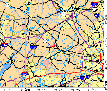
Acton, Massachusetts

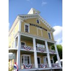
Acton: Historical Society
Acton: Old Town Hall
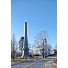
Acton: Acton Center - Isaac Davis Monument & Town Hall

Acton: Acton Memorial Library, Town Center
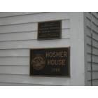
Acton: Hosmer House, Acton MA
- add
your
Submit your own pictures of this town and show them to the world
- OSM Map
- General Map
- Google Map
- MSN Map
Population change since 2000: +7.8%
 |
| Males: 10,754 | |
| Females: 11,170 |
| Median resident age: | 41.9 years |
| Massachusetts median age: | 39.2 years |
Zip codes: 01720.
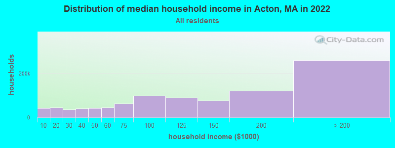
| Acton: | $178,967 |
| MA: | $94,488 |
Estimated per capita income in 2022: $86,994 (it was $41,901 in 2000)
Acton town income, earnings, and wages data
Estimated median house or condo value in 2022: $898,266 (it was $317,800 in 2000)
| Acton: | $898,266 |
| MA: | $534,700 |
Mean prices in 2022: all housing units: $796,617; detached houses: $834,667; townhouses or other attached units: $772,440; in 2-unit structures: $786,250; in 3-to-4-unit structures: $655,835; in 5-or-more-unit structures: $590,321; mobile homes: $144,935
Detailed information about poverty and poor residents in Acton, MA


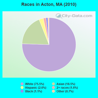
- 16,55575.5%White alone
- 4,06218.5%Asian alone
- 5602.6%Hispanic
- 3401.6%Two or more races
- 2321.1%Black alone
- 1590.7%Other race alone
- 130.06%American Indian alone
- 30.01%Native Hawaiian and Other
Pacific Islander alone
Races in Acton detailed stats: ancestries, foreign born residents, place of birth
According to our research of Massachusetts and other state lists, there was 1 registered sex offender living in Acton, Massachusetts as of April 25, 2024.
The ratio of all residents to sex offenders in Acton is 21,924 to 1.
The ratio of registered sex offenders to all residents in this city is much lower than the state average.
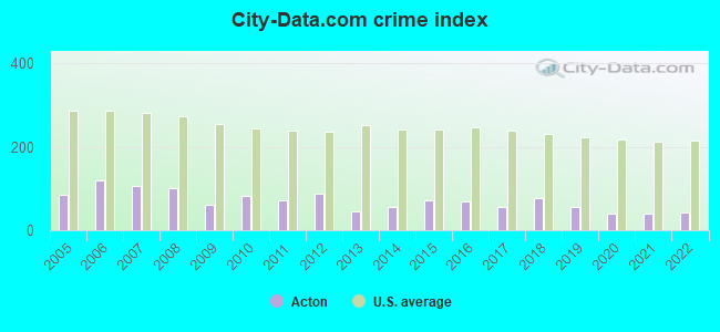
Type |
2009 |
2010 |
2011 |
2012 |
2013 |
2014 |
2015 |
2016 |
2017 |
2018 |
2019 |
2020 |
2021 |
2022 |
|---|---|---|---|---|---|---|---|---|---|---|---|---|---|---|
| Murders (per 100,000) | 0 (0.0) | 1 (4.6) | 0 (0.0) | 0 (0.0) | 0 (0.0) | 0 (0.0) | 0 (0.0) | 1 (4.2) | 0 (0.0) | 1 (4.2) | 0 (0.0) | 0 (0.0) | 0 (0.0) | 0 (0.0) |
| Rapes (per 100,000) | 3 (14.2) | 2 (9.1) | 0 (0.0) | 5 (22.4) | 1 (4.4) | 2 (8.6) | 2 (8.5) | 3 (12.6) | 1 (4.2) | 7 (29.1) | 6 (25.2) | 1 (4.2) | 4 (16.8) | 2 (8.4) |
| Robberies (per 100,000) | 1 (4.7) | 1 (4.6) | 2 (9.1) | 1 (4.5) | 2 (8.7) | 0 (0.0) | 1 (4.2) | 0 (0.0) | 1 (4.2) | 2 (8.3) | 2 (8.4) | 1 (4.2) | 0 (0.0) | 1 (4.2) |
| Assaults (per 100,000) | 11 (52.1) | 20 (91.2) | 31 (140.5) | 19 (85.0) | 5 (21.9) | 15 (64.7) | 20 (84.8) | 20 (84.1) | 21 (87.7) | 15 (62.4) | 24 (100.9) | 14 (59.0) | 4 (16.8) | 12 (50.4) |
| Burglaries (per 100,000) | 32 (151.6) | 43 (196.1) | 24 (108.8) | 40 (179.0) | 31 (135.5) | 28 (120.7) | 61 (258.8) | 23 (96.8) | 33 (137.9) | 27 (112.3) | 14 (58.9) | 16 (67.4) | 16 (67.1) | 14 (58.7) |
| Thefts (per 100,000) | 135 (639.7) | 170 (775.4) | 178 (807.0) | 218 (975.4) | 144 (629.6) | 148 (638.1) | 159 (674.5) | 142 (597.4) | 135 (564.0) | 125 (520.0) | 52 (218.7) | 110 (463.6) | 97 (406.7) | 109 (457.3) |
| Auto thefts (per 100,000) | 5 (23.7) | 7 (31.9) | 5 (22.7) | 2 (8.9) | 3 (13.1) | 5 (21.6) | 7 (29.7) | 5 (21.0) | 3 (12.5) | 4 (16.6) | 3 (12.6) | 4 (16.9) | 6 (25.2) | 4 (16.8) |
| Arson (per 100,000) | 0 (0.0) | 0 (0.0) | 0 (0.0) | 0 (0.0) | 0 (0.0) | 0 (0.0) | 0 (0.0) | 0 (0.0) | 1 (4.2) | 0 (0.0) | 2 (8.4) | 2 (8.4) | 1 (4.2) | 0 (0.0) |
| City-Data.com crime index | 61.3 | 83.3 | 72.5 | 88.5 | 46.2 | 55.5 | 72.5 | 67.7 | 55.4 | 76.6 | 56.8 | 41.0 | 39.7 | 41.8 |
The City-Data.com crime index weighs serious crimes and violent crimes more heavily. Higher means more crime, U.S. average is 246.1. It adjusts for the number of visitors and daily workers commuting into cities.
Crime rate in Acton detailed stats: murders, rapes, robberies, assaults, burglaries, thefts, arson
Full-time law enforcement employees in 2021, including police officers: 51 (40 officers - 36 male; 4 female).
| Officers per 1,000 residents here: | 1.68 |
| Massachusetts average: | 2.53 |
 Recent articles from our blog. Our writers, many of them Ph.D. graduates or candidates, create easy-to-read articles on a wide variety of topics.

 | Acton or…? (77 replies) |
| Searching for Progressive Town, Good Schools, Laid Back... Acton Shrewsbury Hopkinton Stow Ashland Northboro Westboro (37 replies) |
| Local shops around Acton (20 replies) |
| House right next to a small wetland in Acton? (25 replies) |
| Best Donuts, outside of Dunkin, in Acton (17 replies) |
| Commute times from Acton/Maynard to Medford/Sommerville (Tufts) (3 replies) |
Latest news from Acton, MA collected exclusively by city-data.com from local newspapers, TV, and radio stations
Acton, MA City Guides:
Ancestries: Irish (20.5%), English (15.8%), Italian (13.2%), German (11.1%), French (5.7%), Polish (5.4%).
Current Local Time: EST time zone
Incorporated in 1735
Elevation: 260 feet
Land area: 20.0 square miles.
Population density: 1,098 people per square mile (low).
2,915 residents are foreign born (7.6% Asia, 4.0% Europe, 1.6% Latin America).
| This town: | 14.3% |
| Massachusetts: | 12.2% |
| Acton town: | 1.5% ($4,856) |
| Massachusetts: | 1.3% ($2,336) |
Nearest city with pop. 50,000+: Framingham, MA  (12.3 miles , pop. 66,910).
Nearest city with pop. 200,000+: Boston, MA (21.0 miles , pop. 589,141).
Nearest city with pop. 1,000,000+: Bronx, NY (168.8 miles , pop. 1,332,650).
Nearest cities:
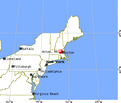
), ), ), Latitude: 42.48 N, Longitude: 71.44 W
Area code: 978

Acton tourist attractions:
Acton, Massachusetts accommodation & food services, waste management - Economy and Business Data
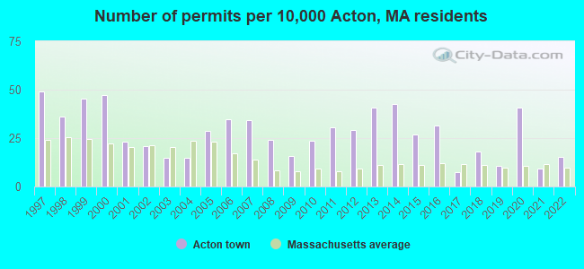
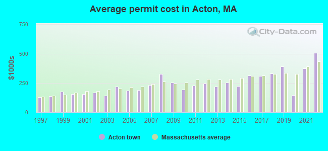
Single-family new house construction building permits:
- 2022: 31 buildings, average cost: $507,900
- 2021: 19 buildings, average cost: $372,500
- 2020: 83 buildings, average cost: $146,800
- 2019: 22 buildings, average cost: $389,100
- 2018: 37 buildings, average cost: $331,200
- 2017: 15 buildings, average cost: $311,000
- 2016: 64 buildings, average cost: $312,900
- 2015: 55 buildings, average cost: $221,500
- 2014: 87 buildings, average cost: $253,700
- 2013: 83 buildings, average cost: $218,200
- 2012: 59 buildings, average cost: $245,800
- 2011: 62 buildings, average cost: $226,400
- 2010: 48 buildings, average cost: $194,500
- 2009: 32 buildings, average cost: $254,500
- 2008: 49 buildings, average cost: $328,000
- 2007: 70 buildings, average cost: $230,900
- 2006: 71 buildings, average cost: $186,700
- 2005: 58 buildings, average cost: $183,800
- 2004: 30 buildings, average cost: $219,900
- 2003: 30 buildings, average cost: $140,800
- 2002: 42 buildings, average cost: $168,000
- 2001: 47 buildings, average cost: $156,400
- 2000: 96 buildings, average cost: $152,700
- 1999: 92 buildings, average cost: $176,800
- 1998: 73 buildings, average cost: $138,000
- 1997: 100 buildings, average cost: $130,700
| Here: | 3.0% |
| Massachusetts: | 3.5% |
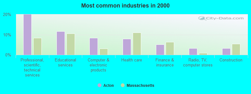
- Professional, scientific, technical services (20.0%)
- Educational services (11.7%)
- Computer & electronic products (8.4%)
- Health care (7.9%)
- Finance & insurance (5.1%)
- Radio, TV, computer stores (3.2%)
- Construction (3.2%)
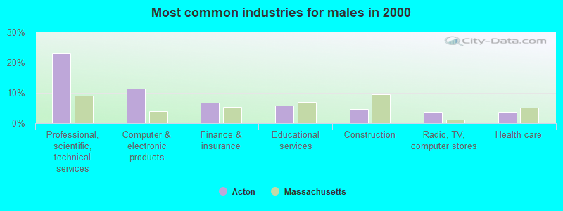
- Professional, scientific, technical services (23.1%)
- Computer & electronic products (11.5%)
- Finance & insurance (6.7%)
- Educational services (5.9%)
- Construction (4.8%)
- Radio, TV, computer stores (3.8%)
- Health care (3.8%)
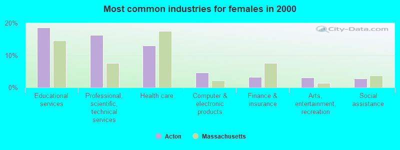
- Educational services (18.7%)
- Professional, scientific, technical services (16.3%)
- Health care (13.0%)
- Computer & electronic products (4.6%)
- Finance & insurance (3.2%)
- Arts, entertainment, recreation (3.2%)
- Social assistance (2.8%)
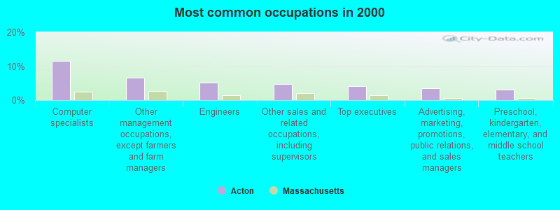
- Computer specialists (11.5%)
- Other management occupations, except farmers and farm managers (6.7%)
- Engineers (5.1%)
- Other sales and related occupations, including supervisors (4.7%)
- Top executives (4.1%)
- Advertising, marketing, promotions, public relations, and sales managers (3.5%)
- Preschool, kindergarten, elementary, and middle school teachers (3.1%)
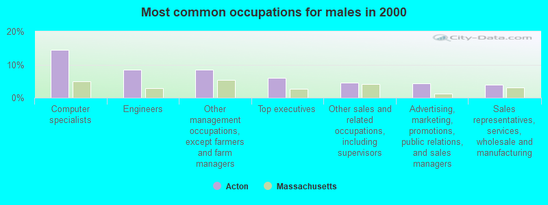
- Computer specialists (14.4%)
- Engineers (8.5%)
- Other management occupations, except farmers and farm managers (8.4%)
- Top executives (6.0%)
- Other sales and related occupations, including supervisors (4.5%)
- Advertising, marketing, promotions, public relations, and sales managers (4.4%)
- Sales representatives, services, wholesale and manufacturing (3.8%)

- Computer specialists (8.1%)
- Secretaries and administrative assistants (5.8%)
- Preschool, kindergarten, elementary, and middle school teachers (5.6%)
- Other office and administrative support workers, including supervisors (5.1%)
- Other sales and related occupations, including supervisors (5.0%)
- Other management occupations, except farmers and farm managers (4.6%)
- Other teachers, instructors, education, training, and library occupations (4.2%)
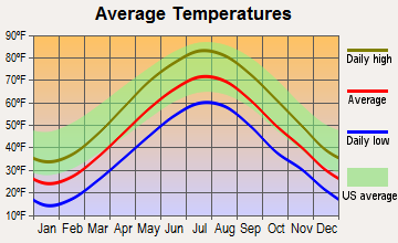
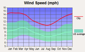
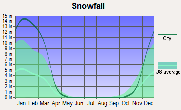
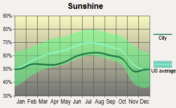
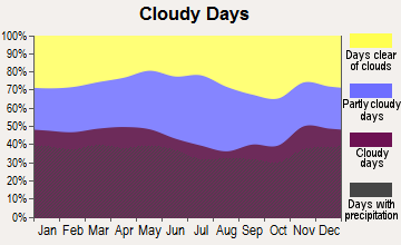
Average climate in Acton, Massachusetts
Based on data reported by over 4,000 weather stations

(lower is better)
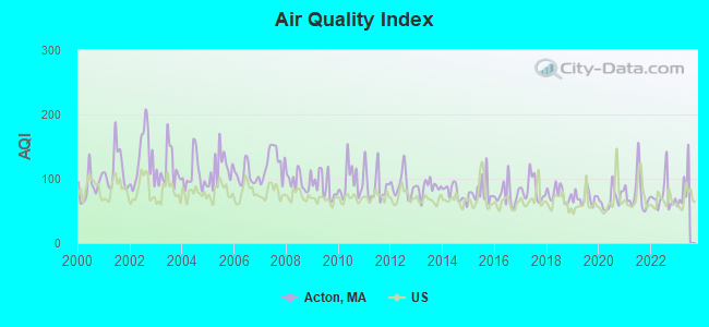
Air Quality Index (AQI) level in 2022 was 73.1. This is about average.
| City: | 73.1 |
| U.S.: | 72.6 |
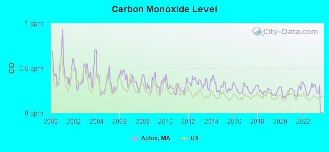
Carbon Monoxide (CO) [ppm] level in 2022 was 0.267. This is about average. Closest monitor was 12.7 miles away from the city center.
| City: | 0.267 |
| U.S.: | 0.251 |

Nitrogen Dioxide (NO2) [ppb] level in 2022 was 9.80. This is significantly worse than average. Closest monitor was 4.5 miles away from the city center.
| City: | 9.80 |
| U.S.: | 5.11 |
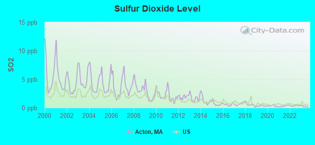
Sulfur Dioxide (SO2) [ppb] level in 2022 was 0.364. This is significantly better than average. Closest monitor was 4.5 miles away from the city center.
| City: | 0.364 |
| U.S.: | 1.515 |
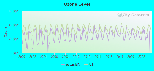
Ozone [ppb] level in 2022 was 26.3. This is better than average. Closest monitor was 9.5 miles away from the city center.
| City: | 26.3 |
| U.S.: | 33.3 |
Particulate Matter (PM2.5) [µg/m3] level in 2022 was 6.75. This is better than average. Closest monitor was 4.9 miles away from the city center.
| City: | 6.75 |
| U.S.: | 8.11 |
Tornado activity:
Acton-area historical tornado activity is slightly above Massachusetts state average. It is 30% smaller than the overall U.S. average.
On 6/9/1953, a category F4 (max. wind speeds 207-260 mph) tornado 12.9 miles away from the Acton town center killed 90 people and injured 1228 people and caused between $50,000,000 and $500,000,000 in damages.
On 10/3/1970, a category F3 (max. wind speeds 158-206 mph) tornado 7.5 miles away from the town center killed one person and caused between $50,000 and $500,000 in damages.
Earthquake activity:
Acton-area historical earthquake activity is significantly above Massachusetts state average. It is 72% smaller than the overall U.S. average.On 10/7/1983 at 10:18:46, a magnitude 5.3 (5.1 MB, 5.3 LG, 5.1 ML, Class: Moderate, Intensity: VI - VII) earthquake occurred 178.3 miles away from the city center
On 4/20/2002 at 10:50:47, a magnitude 5.3 (5.3 ML, Depth: 3.0 mi) earthquake occurred 180.6 miles away from Acton center
On 1/19/1982 at 00:14:42, a magnitude 4.7 (4.5 MB, 4.7 MD, 4.5 LG, Class: Light, Intensity: IV - V) earthquake occurred 71.2 miles away from the city center
On 4/20/2002 at 10:50:47, a magnitude 5.2 (5.2 MB, 4.2 MS, 5.2 MW, 5.0 MW) earthquake occurred 179.9 miles away from the city center
On 10/16/2012 at 23:12:25, a magnitude 4.7 (4.7 ML, Depth: 10.0 mi) earthquake occurred 87.1 miles away from Acton center
On 8/22/1992 at 12:20:32, a magnitude 4.8 (4.8 MB, 3.8 MS, 4.7 LG, Depth: 6.2 mi) earthquake occurred 240.5 miles away from the city center
Magnitude types: regional Lg-wave magnitude (LG), body-wave magnitude (MB), duration magnitude (MD), local magnitude (ML), surface-wave magnitude (MS), moment magnitude (MW)
Natural disasters:
The number of natural disasters in Middlesex County (31) is a lot greater than the US average (15).Major Disasters (Presidential) Declared: 17
Emergencies Declared: 14
Causes of natural disasters: Floods: 12, Storms: 9, Hurricanes: 6, Snowstorms: 6, Winter Storms: 5, Blizzards: 2, Snows: 2, Explosion: 1, Heavy Rain: 1, Snowfall: 1, Water Main Break: 1, Wind: 1 (Note: some incidents may be assigned to more than one category).

Main business address for: PSYCHEMEDICS CORP (SERVICES-MEDICAL LABORATORIES), KADANT INC (SPECIAL INDUSTRY MACHINERY (NO METALWORKING MACHINERY)).
Hospitals and medical centers in Acton:
Colleges/universities with over 2000 students nearest to Acton:
- Middlesex Community College (about 10 miles; Bedford, MA; Full-time enrollment: 6,040)
- Brandeis University (about 13 miles; Waltham, MA; FT enrollment: 6,966)
- Framingham State University (about 13 miles; Framingham, MA; FT enrollment: 5,743)
- Bentley University (about 13 miles; Waltham, MA; FT enrollment: 5,229)
- University of Massachusetts-Lowell (about 14 miles; Lowell, MA; FT enrollment: 12,341)
- Wellesley College (about 15 miles; Wellesley, MA; FT enrollment: 2,658)
- Massachusetts Bay Community College (about 15 miles; Wellesley Hills, MA; FT enrollment: 3,636)
Public high school in Acton:
- ACTON-BOXBOROUGH REGIONAL HIGH (Students: 1,886, Location: 36 CHARTER RD, Grades: 9-12)
Private high school in Acton:
Public elementary/middle schools in Acton:
- RAYMOND J GREY JUNIOR HIGH (Students: 990, Location: 16 CHARTER RD, Grades: 7-8)
- MERRIAM SCHOOL (Students: 597, Location: 11 CHARTER ROAD, Grades: PK-6)
- C.T. DOUGLAS ELEMENTARY SCHOOL (Students: 498, Location: 21 ELM STREET, Grades: KG-6)
- MCCARTHY-TOWNE SCHOOL (Students: 490, Location: 11 CHARTER ROAD, Grades: KG-6)
- LUTHER CONANT SCHOOL (Students: 489, Location: 80 TAYLOR ROAD, Grades: KG-6)
- PAUL P GATES ELEMENTARY SCHOOL (Location: 75 SPRUCE STREET, Grades: KG-6)
Libraries in Acton:
- ACTON MEMORIAL LIBRARY (Operating income: $964,540; Location: 486 MAIN ST.; 129,579 books; 10,463 audio materials; 5,923 video materials; 9 local licensed databases; 31 state licensed databases; 3 other licensed databases; 216 print serial subscriptions)
- W. ACTON CITIZENS' LIBRARY (Operating income: $33,506; Location: 21 WINDSOR AVE.; 12,335 books; 350 audio materials; 150 video materials; 31 state licensed databases; 25 print serial subscriptions)
Points of interest:
Notable locations in Acton: South Acton Station (A), Nashoba Club (B), Acton Plaza (C), Victory Plaza (D), Assabet Plaza (E), Concord-Acton Industrial Park (F), Acton Fire Department Station 1 (G), West Acton Fire Station (H), South Acton Fire Station (I), Acton Memorial Library (J), Acton Town Hall (K), Conant School Library (L), Citizens Library Association of West Acton (M), Discovery Museum (N), Faulkner House (O), Hosmer House Museum (P). Display/hide their locations on the map
Shopping Centers: Acton Shopping Center (1), Acton Mall (2), Acton Shopping Center (3), Acton Mall Shopping Center (4), Acton Plaza Shopping Center (5), Baybank Plaza Shopping Center (6), First National Shopping Center (7). Display/hide their locations on the map
Main business address in Acton include: PSYCHEMEDICS CORP (A), KADANT INC (B). Display/hide their locations on the map
Churches in Acton include: West Acton Baptist Church (A), South Acton Congregational Church (B), Saint Matthews Church (C), Saint Elizabeth of Hungary Church (D), Good Shepherd Church (E), Faith Evangelical Free Church (F), Acton Korean Church (G), Acton Congregational Church (H), Acton Christian Church (I). Display/hide their locations on the map
Cemeteries: Forest Cemetery (1), Woodlawn Cemetery (2), Mount Hope Cemetery (3). Display/hide their locations on the map
Lakes, reservoirs, and swamps: Grassy Pond (A), Barkers Pond (B), Ice House Pond (C), Assabet River Reservoir (D), Nashoba Brook Reservoir (E), Fort Pond Brook Reservoir (F), South Acton Swamp (G). Display/hide their locations on the map
Streams, rivers, and creeks: Butter Brook (A), Nagog Brook (B), Guggins Brook (C), Inch Brook (D), Heath Hen Meadow Brook (E). Display/hide their locations on the map
Parks in Acton include: Stonymeade Conservation Land (1), Jones Field (2), Acton Arboretum (3), Nagog Hill Conservation Area (4), Community Gardens (5), Elm Street Playground (6), Gardner Field (7), Goward Field (8), Grassy Pond Conservation Area (9). Display/hide their locations on the map
Birthplace of: Frederick Heyliger - Soilder, Jamie Eldridge - Politician, Lee Brooks - Film score composer, Bob Brooke - Ice hockey player, Fred Robinson (baseball) - Baseball player, Jeff Norton - Ice hockey player.
Drinking water stations with addresses in Acton and their reported violations in the past:
ACTON WATER SUPPLY DISTRICT (Population served: 21,349, Groundwater under infl of surface water):Past health violations:PINE HILL CONDOMINIUM (Address: 271 GREAT ROAD #29 , Population served: 95, Groundwater):Past monitoring violations:
- MCL, Monthly (TCR) - In JUL-2014, Contaminant: Coliform. Follow-up actions: St AO (w/o penalty) issued (SEP-05-2014), St Compliance achieved (SEP-05-2014)
- MCL, Monthly (TCR) - In NOV-2013, Contaminant: Coliform. Follow-up actions: St AO (w/o penalty) issued (DEC-13-2013), St Compliance achieved (DEC-13-2013)
- MCL, Monthly (TCR) - In SEP-2012, Contaminant: Coliform. Follow-up actions: St AO (w/o penalty) issued (OCT-16-2012), St Compliance achieved (OCT-16-2012)
- MCL, Monthly (TCR) - In AUG-2011, Contaminant: Coliform. Follow-up actions: St AO (w/o penalty) issued (OCT-27-2011), St Compliance achieved (OCT-27-2011)
- MCL, Monthly (TCR) - In JUN-2011, Contaminant: Coliform. Follow-up actions: St AO (w/o penalty) issued (SEP-14-2011), St Compliance achieved (SEP-14-2011)
- MCL, Monthly (TCR) - In OCT-2010, Contaminant: Coliform. Follow-up actions: St AO (w/o penalty) issued (NOV-16-2010), St Compliance achieved (NOV-16-2010)
- 5 other older health violations
- One minor monitoring violation
- 25 regular monitoring violations
Past health violations:STRAWBERRY HILL APARTMENTS (Population served: 80, Groundwater):Past monitoring violations:
- MCL, Monthly (TCR) - In SEP-2012, Contaminant: Coliform. Follow-up actions: St AO (w/o penalty) issued (OCT-26-2012)
- MCL, Monthly (TCR) - In AUG-2012, Contaminant: Coliform. Follow-up actions: St AO (w/o penalty) issued (OCT-26-2012)
- MCL, Monthly (TCR) - In JUL-2011, Contaminant: Coliform. Follow-up actions: St AO (w/o penalty) issued (OCT-27-2011), St Compliance achieved (OCT-27-2011)
- MCL, Monthly (TCR) - In MAR-2007, Contaminant: Coliform. Follow-up actions: St AO (w/o penalty) issued (APR-30-2007), St Compliance achieved (FEB-20-2008)
- MCL, Monthly (TCR) - In FEB-2007, Contaminant: Coliform. Follow-up actions: St AO (w/o penalty) issued (MAR-13-2007), St Compliance achieved (FEB-20-2008)
- MCL, Monthly (TCR) - In DEC-2006, Contaminant: Coliform. Follow-up actions: St Compliance achieved (FEB-12-2007), St AO (w/o penalty) issued (FEB-12-2007), St Compliance achieved (FEB-20-2008)
- MCL, Monthly (TCR) - In NOV-2006, Contaminant: Coliform. Follow-up actions: St Compliance achieved (FEB-12-2007), St AO (w/o penalty) issued (FEB-12-2007), St Compliance achieved (FEB-20-2008)
- Follow-up Or Routine LCR Tap M/R - In OCT-01-2006, Contaminant: Lead and Copper Rule. Follow-up actions: St AO (w/o penalty) issued (DEC-12-2006), St Compliance achieved (FEB-05-2007)
- 3 minor monitoring violations
Past health violations:LIBERTY HOUSE CONDOMINIUM (Population served: 80, Groundwater):Past monitoring violations:
- MCL, Average - Between JAN-2012 and MAR-2012, Contaminant: Combined Radium (-226 and -228). Follow-up actions: St AO (w/o penalty) issued (MAY-29-2012)
- MCL, Monthly (TCR) - In JUL-2008, Contaminant: Coliform. Follow-up actions: St AO (w/o penalty) issued (JUL-22-2008)
- MCL, Monthly (TCR) - In JUN-2006, Contaminant: Coliform. Follow-up actions: St AO (w/o penalty) issued (2 times from AUG-08-2006 to MAR-30-2007), St Compliance achieved (JUN-30-2009)
- Monitoring and Reporting (DBP) - Between JAN-2013 and MAR-2013, Contaminant: Chlorine. Follow-up actions: St AO (w/o penalty) issued (JUN-12-2013)
- Monitoring and Reporting (DBP) - Between OCT-2012 and DEC-2012, Contaminant: Chlorine. Follow-up actions: St AO (w/o penalty) issued (FEB-27-2013), St Compliance achieved (JUN-13-2013)
- Monitoring and Reporting (DBP) - Between JUL-2012 and SEP-2012, Contaminant: Chlorine. Follow-up actions: St AO (w/o penalty) issued (DEC-05-2012), St Compliance achieved (JUN-13-2013)
- Monitoring and Reporting (DBP) - Between APR-2012 and JUN-2012, Contaminant: Chlorine. Follow-up actions: St AO (w/o penalty) issued (SEP-05-2012), St Compliance achieved (JUN-13-2013)
- Monitoring, Repeat Major (TCR) - In SEP-2007, Contaminant: Coliform (TCR). Follow-up actions: St AO (w/o penalty) issued (OCT-31-2007)
- 10 minor monitoring violations
- 34 regular monitoring violations
- 3 other older monitoring violations
Past health violations:Past monitoring violations:
- MCL, Monthly (TCR) - In JAN-2014, Contaminant: Coliform. Follow-up actions: St AO (w/o penalty) issued (MAR-03-2014), St Compliance achieved (MAR-03-2014)
- Follow-up Or Routine LCR Tap M/R - In JUL-01-2008, Contaminant: Lead and Copper Rule. Follow-up actions: St AO (w/o penalty) issued (DEC-05-2008), St Compliance achieved (SEP-28-2010)
- 3 routine major monitoring violations
- 6 regular monitoring violations
| This town: | 2.7 people |
| Massachusetts: | 2.5 people |
| This town: | 72.8% |
| Whole state: | 63.0% |
| This town: | 4.0% |
| Whole state: | 7.0% |
Likely homosexual households (counted as self-reported same-sex unmarried-partner households)
- Lesbian couples: 0.4% of all households
- Gay men: 0.2% of all households
| This town: | 2.9% |
| Whole state: | 9.3% |
| This town: | 1.1% |
| Whole state: | 4.4% |
People in group quarters in Acton in 2010:
- 111 people in nursing facilities/skilled-nursing facilities
- 21 people in group homes intended for adults
- 4 people in workers' group living quarters and job corps centers
People in group quarters in Acton in 2000:
- 129 people in nursing homes
- 10 people in homes for the mentally ill
- 3 people in religious group quarters
Banks with branches in Acton (2011 data):
- Middlesex Savings Bank: Acton Branch at 577 Massachusetts Avenue, branch established on 1982/05/21; Shopping Center Branch at 291 Main Street, branch established on 1960/02/01. Info updated 2009/07/16: Bank assets: $4,034.8 mil, Deposits: $3,490.0 mil, headquarters in Natick, MA, positive income, Mortgage Lending Specialization, 33 total offices, Holding Company: Middlesex Bancorp Mhc
- Cambridge Savings Bank: Acton Branch at 145 Great Road, branch established on 2003/01/13. Info updated 2007/01/05: Bank assets: $2,316.4 mil, Deposits: $1,902.8 mil, headquarters in Cambridge, MA, positive income, Commercial Lending Specialization, 18 total offices, Holding Company: Cambridge Financial Group, Inc.
- Northern Bank & Trust Company: Acton Branch at 414 Massachusetts Avenue, branch established on 1892/01/01. Info updated 2012/02/08: Bank assets: $734.7 mil, Deposits: $586.1 mil, headquarters in Woburn, MA, positive income, Commercial Lending Specialization, 11 total offices, Holding Company: Northern Bancorp, Inc.
- Sovereign Bank, National Association: Acton Branch at 409 Massachusetts Ave, branch established on 1961/07/01. Info updated 2012/01/31: Bank assets: $78,146.9 mil, Deposits: $48,042.9 mil, headquarters in Wilmington, DE, positive income, Commercial Lending Specialization, 718 total offices, Holding Company: Banco Santander, S.A.
- RBS Citizens, National Association: Acton Branch at 270 Great Road, branch established on 1972/09/18. Info updated 2007/09/19: Bank assets: $106,940.6 mil, Deposits: $75,690.2 mil, headquarters in Providence, RI, positive income, 1135 total offices, Holding Company: Uk Financial Investments Limited
- Bank of America, National Association: Acton Branch at 271 Great Road, branch established on 1982/01/04. Info updated 2009/11/18: Bank assets: $1,451,969.3 mil, Deposits: $1,077,176.8 mil, headquarters in Charlotte, NC, positive income, 5782 total offices, Holding Company: Bank Of America Corporation
- Enterprise Bank and Trust Company: Acton Branch at 340 Great Road, branch established on 2009/01/12. Info updated 2006/11/03: Bank assets: $1,488.4 mil, Deposits: $1,333.6 mil, headquarters in Lowell, MA, positive income, Commercial Lending Specialization, 20 total offices, Holding Company: Enterprise Bancorp, Inc.
For population 15 years and over in Acton:
- Never married: 21.4%
- Now married: 67.4%
- Separated: 0.9%
- Widowed: 3.7%
- Divorced: 6.5%
For population 25 years and over in Acton:
- High school or higher: 97.8%
- Bachelor's degree or higher: 69.3%
- Graduate or professional degree: 33.9%
- Unemployed: 2.0%
- Mean travel time to work (commute): 31.0 minutes
| Here: | 9.0 |
| Massachusetts average: | 13.1 |


Graphs represent county-level data. Detailed 2008 Election Results
Religion statistics for Acton, MA (based on Middlesex County data)


| Religion | Adherents | Congregations |
|---|---|---|
| Catholic | 718,209 | 107 |
| Mainline Protestant | 70,053 | 269 |
| Other | 68,480 | 199 |
| Evangelical Protestant | 41,270 | 304 |
| Orthodox | 23,641 | 28 |
| Black Protestant | 2,276 | 8 |
| None | 579,156 | - |
Food Environment Statistics:
| Middlesex County: | 1.71 / 10,000 pop. |
| Massachusetts: | 1.98 / 10,000 pop. |
| This county: | 0.03 / 10,000 pop. |
| State: | 0.05 / 10,000 pop. |
| Middlesex County: | 2.14 / 10,000 pop. |
| Massachusetts: | 2.22 / 10,000 pop. |
| Middlesex County: | 1.38 / 10,000 pop. |
| State: | 1.77 / 10,000 pop. |
| Here: | 7.84 / 10,000 pop. |
| State: | 8.76 / 10,000 pop. |
| This county: | 7.8% |
| Massachusetts: | 8.1% |
| Middlesex County: | 21.5% |
| Massachusetts: | 22.5% |
| This county: | 18.0% |
| State: | 16.5% |
6.91% of this county's 2021 resident taxpayers lived in other counties in 2020 ($102,955 average adjusted gross income)
| Here: | 6.91% |
| Massachusetts average: | 6.35% |
0.01% of residents moved from foreign countries ($137 average AGI)
Middlesex County: 0.01% Massachusetts average: 0.01%
Top counties from which taxpayers relocated into this county between 2020 and 2021:
| from Suffolk County, MA | |
| from Essex County, MA | |
| from Norfolk County, MA |
8.22% of this county's 2020 resident taxpayers moved to other counties in 2021 ($123,369 average adjusted gross income)
| Here: | 8.22% |
| Massachusetts average: | 7.18% |
0.01% of residents moved to foreign countries ($124 average AGI)
Middlesex County: 0.01% Massachusetts average: 0.02%
Top counties to which taxpayers relocated from this county between 2020 and 2021:
| to Suffolk County, MA | |
| to Essex County, MA | |
| to Worcester County, MA |
| Businesses in Acton, MA | ||||
| Name | Count | Name | Count | |
|---|---|---|---|---|
| AT&T | 1 | McDonald's | 1 | |
| Ace Hardware | 1 | New Balance | 3 | |
| Ann Taylor | 1 | Nike | 2 | |
| CVS | 2 | Pier 1 Imports | 1 | |
| Chevrolet | 1 | RadioShack | 1 | |
| Chico's | 1 | Rite Aid | 1 | |
| Decora Cabinetry | 2 | SAS Shoes | 1 | |
| Domino's Pizza | 1 | Staples | 1 | |
| Dunkin Donuts | 5 | Starbucks | 1 | |
| FedEx | 8 | Stop & Shop | 1 | |
| Ford | 1 | Subaru | 1 | |
| GNC | 1 | Subway | 1 | |
| Gymboree | 1 | T-Mobile | 1 | |
| H&R Block | 1 | T.J.Maxx | 1 | |
| J. Jill | 1 | Talbots | 1 | |
| JoS. A. Bank | 1 | Trader Joe's | 1 | |
| Kmart | 1 | U-Haul | 2 | |
| MasterBrand Cabinets | 3 | UPS | 6 | |
Strongest AM radio stations in Acton:
- WBNW (1120 AM; 5 kW; CONCORD, MA; Owner: MONEY MATTERS RADIO, INC.)
- WRKO (680 AM; 50 kW; BOSTON, MA; Owner: ENTERCOM BOSTON LICENSE, LLC)
- WKOX (1200 AM; 50 kW; FRAMINGHAM, MA; Owner: CAPSTAR TX LIMITED PARTNERSHIP)
- WBIX (1060 AM; 40 kW; NATICK, MA; Owner: LANGER BROADCASTING CORPORATION)
- WEEI (850 AM; 50 kW; BOSTON, MA; Owner: ENTERCOM BOSTON LICENSE, LLC)
- WWZN (1510 AM; 50 kW; BOSTON, MA; Owner: ROSE CITY RADIO CORPORATION)
- WRCA (1330 AM; 25 kW; WALTHAM, MA; Owner: WRCA LICENSE, LLC)
- WAMG (890 AM; 25 kW; DEDHAM, MA; Owner: MEGA COMMUNICATIONS OF DEDHAM LICENSEE, LLC)
- WCRN (830 AM; 50 kW; WORCESTER, MA; Owner: CARTER BROADCASTING CORPORATION)
- WAZN (1470 AM; 7 kW; MARLBOROUGH, MA; Owner: MULTICULTURAL RADIO BROADCASTING, INC.)
- WBZ (1030 AM; 50 kW; BOSTON, MA; Owner: INFINITY BROADCASTING OPERATIONS, INC.)
- WUNR (1600 AM; 20 kW; BROOKLINE, MA; Owner: CHAMPION BROADCASTING SYSTEMS, INC.)
- WNTN (1550 AM; 10 kW; NEWTON, MA; Owner: COLT COMMUNICATIONS, LLC)
Strongest FM radio stations in Acton:
- WHAB (89.1 FM; ACTON, MA; Owner: ACTON-BOXBOROUGH REGIONAL SCH. DIST.)
- WBMX (98.5 FM; BOSTON, MA; Owner: INFINITY RADIO OPERATIONS INC.)
- WJMN (94.5 FM; BOSTON, MA; Owner: AMFM RADIO LICENSES, L.L.C.)
- WCRB (102.5 FM; WALTHAM, MA; Owner: CHARLES RIVER BROADCASTING WCRB LICE)
- WTKK (96.9 FM; BOSTON, MA; Owner: GREATER BOSTON RADIO, INC.)
- WROR-FM (105.7 FM; FRAMINGHAM, MA; Owner: GREATER BOSTON RADIO, INC.)
- WBOS (92.9 FM; BROOKLINE, MA; Owner: GREATER BOSTON RADIO, INC.)
- WGBH (89.7 FM; BOSTON, MA; Owner: WGBH EDUCATIONAL FOUNDATION)
- WBUR-FM (90.9 FM; BOSTON, MA; Owner: TRUSTEES OF BOSTON UNIVERSITY)
- WODS (103.3 FM; BOSTON, MA; Owner: INFINITY BROADCASTING OPERATIONS, INC.)
- WXKS-FM (107.9 FM; MEDFORD, MA; Owner: AMFM RADIO LICENSES, L.L.C.)
- WMJX (106.7 FM; BOSTON, MA; Owner: GREATER BOSTON RADIO, INC.)
- WYAJ (97.7 FM; SUDBURY, MA; Owner: SUDBURY VALLEY B'CASTING FOUNDATION)
- WKLB-FM (99.5 FM; LOWELL, MA; Owner: GREATER BOSTON RADIO, INC.)
- WAAF (107.3 FM; WORCESTER, MA; Owner: ENTERCOM BOSTON LICENSE, LLC)
- WBCN (104.1 FM; BOSTON, MA; Owner: HEMISPHERE BROADCASTING CORPORATION)
- WZLX (100.7 FM; BOSTON, MA; Owner: INFINITY BROADCASTING CORPORATION OF BOSTON)
- W267AI (101.3 FM; BOSTON, MA; Owner: MCC BROADCASTING COMPANY, INC.)
- W227AM (93.3 FM; ANDOVER, MA; Owner: GREATER BOSTON RADIO, INC.)
- WERS (88.9 FM; BOSTON, MA; Owner: EMERSON COLLEGE)
TV broadcast stations around Acton:
- WUTF (Channel 66; MARLBOROUGH, MA; Owner: TELEFUTURA BOSTON LLC)
- WCVB-TV (Channel 5; BOSTON, MA; Owner: WCVB HEARST-ARGYLE TV, INC.)
- WGBH-TV (Channel 2; BOSTON, MA; Owner: WGBH EDUCATIONAL FOUNDATION)
- WHDH-TV (Channel 7; BOSTON, MA; Owner: WHDH-TV)
- WBZ-TV (Channel 4; BOSTON, MA; Owner: VIACOM INC.)
- WGBX-TV (Channel 44; BOSTON, MA; Owner: WGBH EDUCATIONAL FOUNDATION)
- WMFP (Channel 62; LAWRENCE, MA; Owner: WSAH LICENSE, INC.)
- WSBK-TV (Channel 38; BOSTON, MA; Owner: VIACOM INC.)
- WLVI-TV (Channel 56; CAMBRIDGE, MA; Owner: WLVI, INC.)
- WUNI (Channel 27; WORCESTER, MA; Owner: ENTRAVISION HOLDINGS, LLC)
- WFXT (Channel 25; BOSTON, MA; Owner: FOX TELEVISION STATIONS INC.)
- W40BO (Channel 40; BOSTON, MA; Owner: PAXSON COMMUNICATIONS LPTV, INC.)
- WBPX (Channel 68; BOSTON, MA; Owner: PAXSON BOSTON-68 LICENSE, INC.)
- WTMU-LP (Channel 32; BOSTON, MA; Owner: ZGS BOSTON, INC.)
- WCEA-LP (Channel 58; BOSTON, MA; Owner: CHANNEL 19 TV CORPORATION)
- WFXZ-CA (Channel 24; BOSTON, MA; Owner: BOSTON BROADCASTING CORP.)
- WNDS (Channel 50; DERRY, NH; Owner: CTV OF DERRY, INC)
- WWDP (Channel 46; NORWELL, MA; Owner: NORWELL TELEVISION, LLC)
- WYDN (Channel 48; WORCESTER, MA; Owner: EDUCATIONAL PUBLIC TV CORPORATION)
- WNAC-TV (Channel 64; PROVIDENCE, RI; Owner: WNAC, LLC)
- WPRI-TV (Channel 12; PROVIDENCE, RI; Owner: TVL BROADCASTING OF RHODE ISLAND, LLC)
- WLNE-TV (Channel 6; NEW BEDFORD, MA; Owner: FREEDOM BROADCASTING OF SOUTHERN NEW ENGLAND, INC.)
- National Bridge Inventory (NBI) Statistics
- 26Number of bridges
- 95ft / 28.9mTotal length
- $20,832,000Total costs
- 392,003Total average daily traffic
- 10,280Total average daily truck traffic
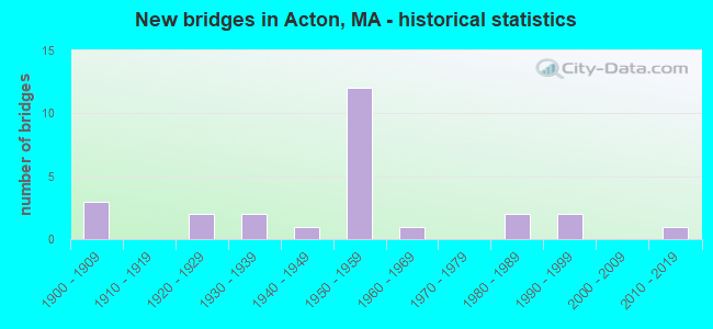
- New bridges - historical statistics
- 31900-1909
- 21920-1929
- 21930-1939
- 11940-1949
- 121950-1959
- 11960-1969
- 21980-1989
- 21990-1999
- 12010-2019
FCC Registered Antenna Towers:
32 (See the full list of FCC Registered Antenna Towers in Acton)FCC Registered Private Land Mobile Towers:
1 (See the full list of FCC Registered Private Land Mobile Towers in Acton, MA)FCC Registered Broadcast Land Mobile Towers:
9 (See the full list of FCC Registered Broadcast Land Mobile Towers)FCC Registered Microwave Towers:
2- ACTON, 211 Main St (Lat: 42.468306 Lon: -71.454306), Type: Pole, Structure height: 46.6 m, Overall height: 51.8 m, Call Sign: WMQ511,
Assigned Frequencies: 6417.14 MHz, 11647.5 MHz, Grant Date: 02/23/2011, Expiration Date: 02/01/2021, Cancellation Date: 05/04/2017, Certifier: Carol L Tacker, Registrant: At&t Mobility LLC, 3300 E. Renner Road, B3132, Richardson, TX 75082, Phone: (855) 699-7073, Fax: (972) 907-1131, Email:
- BOS0633, 221 Main Street (Lat: 42.468306 Lon: -71.454333), Type: Tower, Structure height: 53.3 m, Call Sign: WQDU810, Licensee ID: L01728370,
Assigned Frequencies: 10875.0 MHz, 10567.5 MHz, Grant Date: 11/03/2005, Expiration Date: 11/03/2015, Cancellation Date: 09/09/2013, Certifier: Joseph M Sandri Jr., Registrant: Fibertower Network Services, Corp., Debtor-In-Possession, 1875 Eye Street, Nw, 5th Floor, Room 505, Washington, DC 20006, Phone: (202) 223-1028, Email:
FCC Registered Amateur Radio Licenses:
204 (See the full list of FCC Registered Amateur Radio Licenses in Acton)FAA Registered Aircraft:
16 (See the full list of FAA Registered Aircraft in Acton)2003 - 2018 National Fire Incident Reporting System (NFIRS) incidents
- Fire incident types reported to NFIRS in Acton, MA
- 41555.2%Structure Fires
- 25533.9%Outside Fires
- 456.0%Mobile Property/Vehicle Fires
- 374.9%Other
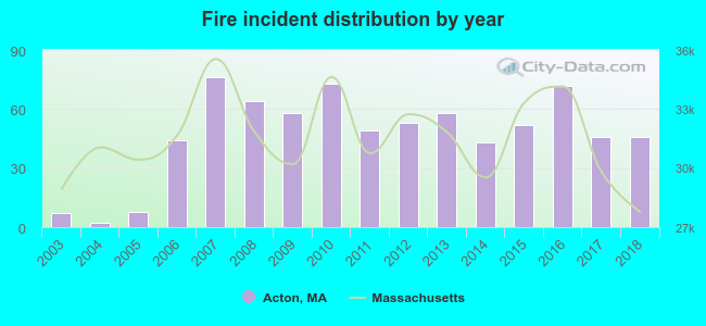 Based on the data from the years 2003 - 2018 the average number of fires per year is 47. The highest number of fire incidents - 76 took place in 2007, and the least - 2 in 2004. The data has a growing trend.
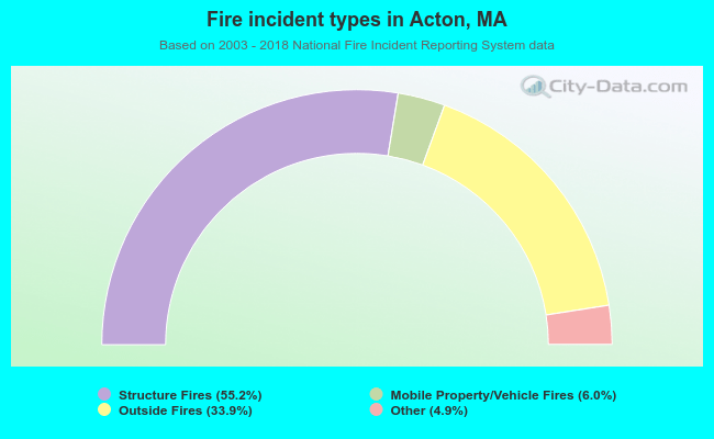 When looking into fire subcategories, the most reports belonged to: Structure Fires (55.2%), and Outside Fires (33.9%).
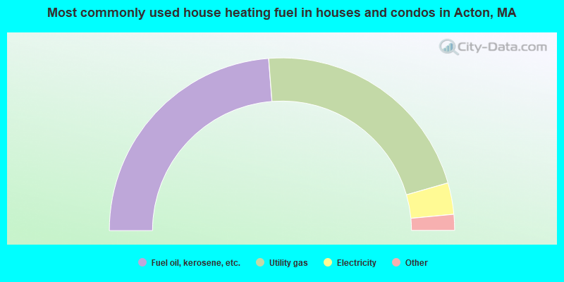
- 47.6%Fuel oil, kerosene, etc.
- 43.6%Utility gas
- 5.9%Electricity
- 2.2%Bottled, tank, or LP gas
- 0.6%Wood
- 0.1%Solar energy
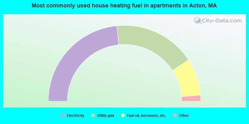
- 46.8%Electricity
- 34.9%Utility gas
- 15.7%Fuel oil, kerosene, etc.
- 1.9%Bottled, tank, or LP gas
- 0.7%No fuel used
Acton compared to Massachusetts state average:
- Median household income above state average.
- Median house value above state average.
- Unemployed percentage significantly below state average.
- Black race population percentage significantly below state average.
- Hispanic race population percentage significantly below state average.
- Renting percentage below state average.
- Length of stay since moving in significantly above state average.
- Number of rooms per house significantly below state average.
- House age significantly below state average.
- Number of college students below state average.
- Percentage of population with a bachelor's degree or higher above state average.
Acton on our top lists:
- #1 on the list of "Top 101 cities with largest percentage of females in occupations: computer specialists (population 5,000+)"
- #2 on the list of "Top 101 cities with largest percentage of males in industries: radio, tv, and computer stores (population 5,000+)"
- #5 on the list of "Top 101 cities with largest percentage of males in occupations: computer specialists (population 5,000+)"
- #5 on the list of "Top 101 cities with largest percentage of males in industries: data processing, libraries, and other information services (population 5,000+)"
- #8 on the list of "Top 101 cities with largest percentage of females in industries: radio, tv, and computer stores (population 5,000+)"
- #16 on the list of "Top 101 cities with largest percentage of females in occupations: librarians, curators, and archivists (population 5,000+)"
- #17 on the list of "Top 101 cities with largest percentage of males in occupations: advertising, marketing, promotions, public relations, and sales managers (population 5,000+)"
- #22 on the list of "Top 101 cities with largest percentage of males in occupations: engineers (population 5,000+)"
- #27 on the list of "Top 101 cities with largest percentage of females in occupations: operations specialties managers except financial managers (population 5,000+)"
- #27 on the list of "Top 101 cities with largest percentage of males in industries: computer and electronic products (population 5,000+)"
- #41 on the list of "Top 101 cities with largest percentage of females in industries: data processing, libraries, and other information services (population 5,000+)"
- #49 on the list of "Top 101 cities with largest percentage of males in industries: professional and commercial equipment and supplies merchant wholesalers (population 5,000+)"
- #68 on the list of "Top 101 cities with largest percentage of females in industries: computer and electronic products (population 5,000+)"
- #80 on the list of "Top 101 cities with largest percentage of females in industries: sporting goods, camera, and hobby and toy stores (population 5,000+)"
- #82 on the list of "Top 101 cities with largest percentage of males in industries: publishing, and motion picture and sound recording industries (population 5,000+)"
- #87 on the list of "Top 101 cities with largest percentage of females in industries: apparel, fabrics, and notions merchant wholesalers (population 5,000+)"
- #4 on the list of "Top 101 counties with the most Orthodox adherents"
- #7 on the list of "Top 101 counties with the most Catholic adherents"
- #7 on the list of "Top 101 counties with the most Mainline Protestant congregations"
- #7 on the list of "Top 101 counties with the most Orthodox congregations"
- #8 on the list of "Top 101 counties with the lowest percentage of residents that keep firearms around their homes"

|
|
Total of 3750 patent applications in 2008-2024.