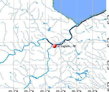
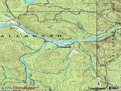
Allagash, Maine
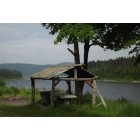
Allagash: Walker Brook Campsite, Allagash Maine
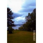
Allagash: looking up the St. John River a short ways before the school
- add
your
Submit your own pictures of this town and show them to the world
- OSM Map
- General Map
- Google Map
- MSN Map
Population change since 2000: -13.7%
 |
| Males: 117 | |
| Females: 122 |
| Median resident age: | 57.8 years |
| Maine median age: | 43.0 years |
Zip codes: 04774.
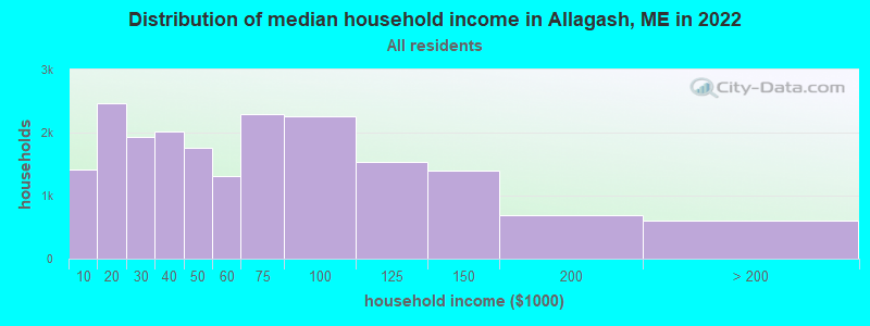
| Allagash: | $32,303 |
| ME: | $69,543 |
Estimated per capita income in 2022: $24,699 (it was $11,968 in 2000)
Allagash town income, earnings, and wages data
Estimated median house or condo value in 2022: $113,798 (it was $47,000 in 2000)
| Allagash: | $113,798 |
| ME: | $290,600 |
Mean prices in 2022: all housing units: $179,108; detached houses: $185,023; townhouses or other attached units: $218,327; in 2-unit structures: $262,505; in 3-to-4-unit structures: $121,406; in 5-or-more-unit structures: $185,084; mobile homes: $117,009; occupied boats, rvs, vans, etc.: $12,682
Detailed information about poverty and poor residents in Allagash, ME


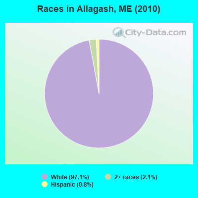
- 23297.1%White alone
- 52.1%Two or more races
- 20.8%Hispanic
Races in Allagash detailed stats: ancestries, foreign born residents, place of birth
 Recent articles from our blog. Our writers, many of them Ph.D. graduates or candidates, create easy-to-read articles on a wide variety of topics.

 | Bangor Daily News Article About The Allagash. (9 replies) |
| Maine weather thread (3207 replies) |
| Canoe Trip Advice Sought (26 replies) |
| Moving from Austin to Allagash (190 replies) |
| Maine for a week - what else to do? (58 replies) |
| Maine and IPAs --- Or, is there life beyond Pale Ale? (11 replies) |
Latest news from Allagash, ME collected exclusively by city-data.com from local newspapers, TV, and radio stations
Ancestries: Irish (46.6%), French (27.4%), United States (11.9%), English (9.4%), Scotch-Irish (9.0%), Scottish (2.5%).
Current Local Time: EST time zone
Incorporated on 09/28/1885
Elevation: 624 feet
Land area: 128.5 square miles.
Population density: 1.9 people per square mile (very low).
| Allagash town: | 0.8% ($380) |
| Maine: | 1.5% ($1,417) |
Nearest city with pop. 50,000+: Portland, ME  (244.3 miles , pop. 64,249).
Nearest city with pop. 200,000+: Boston, MA (344.8 miles , pop. 589,141).
Nearest city with pop. 1,000,000+: Bronx, NY (493.8 miles , pop. 1,332,650).
Nearest cities:
), ), ), ), Latitude: 47.09 N, Longitude: 69.06 W
Area code commonly used in this area: 207

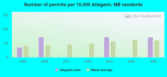
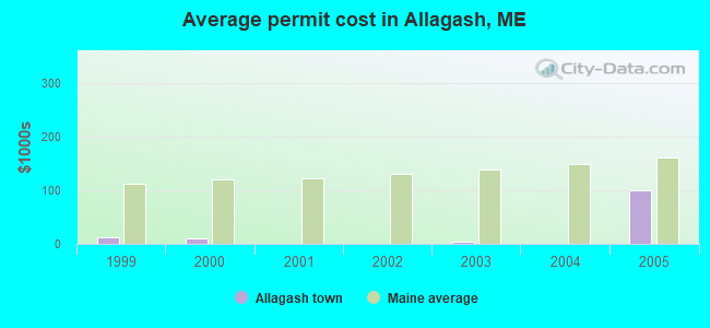
Single-family new house construction building permits:
- 2005: 2 buildings, average cost: $100,000
- 2003: 2 buildings, average cost: $4,500
- 2000: 2 buildings, average cost: $11,000
- 1999: 1 building, cost: $12,000
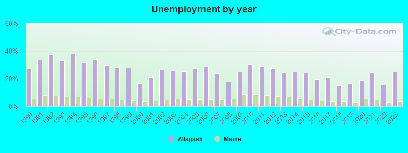
| Here: | 25.0% |
| Maine: | 3.4% |
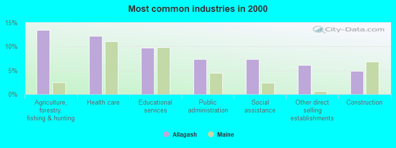
- Agriculture, forestry, fishing & hunting (13.4%)
- Health care (12.2%)
- Educational services (9.8%)
- Public administration (7.3%)
- Social assistance (7.3%)
- Other direct selling establishments (6.1%)
- Construction (4.9%)
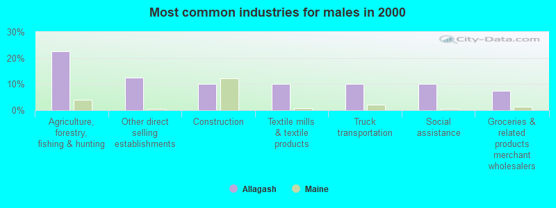
- Agriculture, forestry, fishing & hunting (22.5%)
- Other direct selling establishments (12.5%)
- Construction (10.0%)
- Textile mills & textile products (10.0%)
- Truck transportation (10.0%)
- Social assistance (10.0%)
- Groceries & related products merchant wholesalers (7.5%)

- Health care (23.8%)
- Educational services (19.0%)
- Public administration (14.3%)
- Religious, grantmaking, civic, professional, similar organizations (9.5%)
- Wood products (7.1%)
- Agriculture, forestry, fishing & hunting (4.8%)
- Apparel (4.8%)
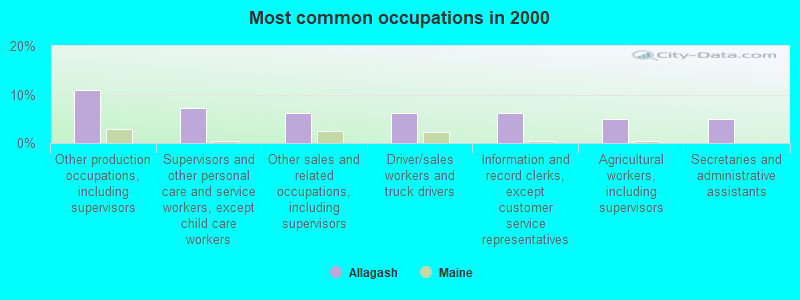
- Other production occupations, including supervisors (11.0%)
- Supervisors and other personal care and service workers, except child care workers (7.3%)
- Other sales and related occupations, including supervisors (6.1%)
- Driver/sales workers and truck drivers (6.1%)
- Information and record clerks, except customer service representatives (6.1%)
- Agricultural workers, including supervisors (4.9%)
- Secretaries and administrative assistants (4.9%)

- Other production occupations, including supervisors (17.5%)
- Other sales and related occupations, including supervisors (12.5%)
- Driver/sales workers and truck drivers (12.5%)
- Supervisors and other personal care and service workers, except child care workers (10.0%)
- Agricultural workers, including supervisors (10.0%)
- Textile, apparel, and furnishings workers (10.0%)
- Fishing, hunting, and forestry occupations (7.5%)
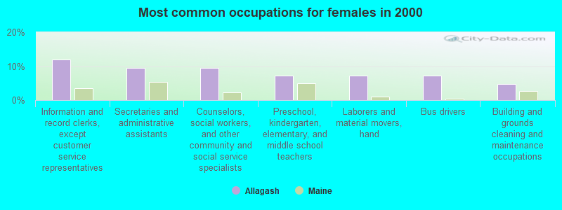
- Information and record clerks, except customer service representatives (11.9%)
- Secretaries and administrative assistants (9.5%)
- Counselors, social workers, and other community and social service specialists (9.5%)
- Preschool, kindergarten, elementary, and middle school teachers (7.1%)
- Laborers and material movers, hand (7.1%)
- Bus drivers (7.1%)
- Building and grounds cleaning and maintenance occupations (4.8%)
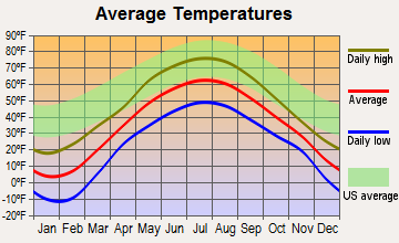
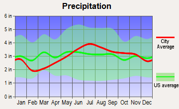
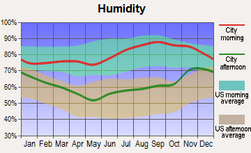
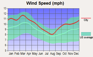
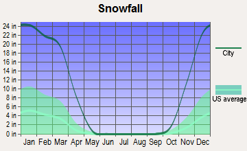
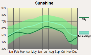
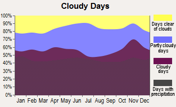
Average climate in Allagash, Maine
Based on data reported by over 4,000 weather stations
Earthquake activity:
Allagash-area historical earthquake activity is above Maine state average. It is 87% smaller than the overall U.S. average.On 4/20/2002 at 10:50:47, a magnitude 5.3 (5.3 ML, Depth: 3.0 mi, Class: Moderate, Intensity: VI - VII) earthquake occurred 286.1 miles away from the city center
On 7/14/2006 at 09:34:48, a magnitude 3.9 (3.9 MD, Depth: 8.6 mi, Class: Light, Intensity: II - III) earthquake occurred 23.1 miles away from Allagash center
On 4/20/2002 at 10:50:47, a magnitude 5.2 (5.2 MB, 4.2 MS, 5.2 MW, 5.0 MW) earthquake occurred 288.0 miles away from the city center
On 10/7/1983 at 10:18:46, a magnitude 5.3 (5.1 MB, 5.3 LG, 5.1 ML) earthquake occurred 335.6 miles away from the city center
On 10/16/2012 at 23:12:25, a magnitude 4.7 (4.7 ML, Depth: 10.0 mi, Class: Light, Intensity: IV - V) earthquake occurred 253.9 miles away from Allagash center
On 1/19/1982 at 00:14:42, a magnitude 4.7 (4.5 MB, 4.7 MD, 4.5 LG) earthquake occurred 277.6 miles away from the city center
Magnitude types: regional Lg-wave magnitude (LG), body-wave magnitude (MB), duration magnitude (MD), local magnitude (ML), surface-wave magnitude (MS), moment magnitude (MW)
Natural disasters:
The number of natural disasters in Aroostook County (22) is greater than the US average (15).Major Disasters (Presidential) Declared: 13
Emergencies Declared: 9
Causes of natural disasters: Floods: 10, Storms: 8, Snows: 7, Heavy Rains: 2, Blizzard: 1, Hurricane: 1, Ice Storm: 1, Snowfall: 1, Snowstorm: 1, Wind: 1, Winter Storm: 1, Other: 2 (Note: some incidents may be assigned to more than one category).
Colleges/universities with over 2000 students nearest to Allagash:
- University of Maine (about 154 miles; Orono, ME; Full-time enrollment: 8,931)
- Husson University (about 158 miles; Bangor, ME; FT enrollment: 2,421)
- University of Maine at Farmington (about 176 miles; Farmington, ME; FT enrollment: 2,036)
- University of Maine at Augusta (about 194 miles; Augusta, ME; FT enrollment: 3,204)
- Saint Joseph's College of Maine (about 237 miles; Standish, ME; FT enrollment: 2,010)
- University of Southern Maine (about 245 miles; Portland, ME; FT enrollment: 6,647)
- Southern Maine Community College (about 246 miles; South Portland, ME; FT enrollment: 4,666)
Points of interest:
Notable locations in Allagash: Allagash Inn (A), Allagash Fire Department (B). Display/hide their locations on the map
Cemeteries: Bolton Cemetery (1), Saint Paul Cemetery (2). Display/hide their locations on the map
Lake: Little Falls Pond (A). Display/hide its location on the map
Streams, rivers, and creeks: Aegan Brook (A), Allagash River (B), Thoroughfare Brook (C), Little Black River (D), Walker Brook (E), West Twin Brook (F), White Brook (G), Kelly Brook (H), Bass Brook (I). Display/hide their locations on the map
Birthplace of: Cathie Pelletier - Novelist.
| This town: | 1.9 people |
| Maine: | 2.3 people |
| This town: | 61.3% |
| Whole state: | 62.9% |
| This town: | 6.5% |
| Whole state: | 9.4% |
Likely homosexual households (counted as self-reported same-sex unmarried-partner households)
- Lesbian couples: 0.0% of all households
- Gay men: 0.8% of all households
| This town: | 18.8% |
| Whole state: | 10.9% |
| This town: | 6.3% |
| Whole state: | 4.1% |
For population 15 years and over in Allagash:
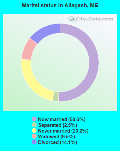
- Never married: 23.2%
- Now married: 50.6%
- Separated: 2.5%
- Widowed: 9.5%
- Divorced: 14.1%
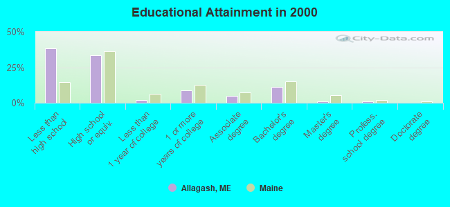
For population 25 years and over in Allagash:
- High school or higher: 61.4%
- Bachelor's degree or higher: 12.9%
- Graduate or professional degree: 1.9%
- Unemployed: 9.9%
- Mean travel time to work (commute): 44.6 minutes
| Here: | 16.8 |
| Maine average: | 11.2 |


Graphs represent county-level data. Detailed 2008 Election Results
Religion statistics for Allagash, ME (based on Aroostook County data)


| Religion | Adherents | Congregations |
|---|---|---|
| Catholic | 22,200 | 27 |
| Mainline Protestant | 5,845 | 40 |
| Evangelical Protestant | 4,411 | 51 |
| Other | 957 | 7 |
| Orthodox | 10 | 1 |
| None | 38,447 | - |
Food Environment Statistics:
| Aroostook County: | 4.03 / 10,000 pop. |
| Maine: | 2.80 / 10,000 pop. |
| This county: | 0.14 / 10,000 pop. |
| State: | 0.14 / 10,000 pop. |
| Aroostook County: | 2.22 / 10,000 pop. |
| Maine: | 2.20 / 10,000 pop. |
| Aroostook County: | 7.78 / 10,000 pop. |
| State: | 5.75 / 10,000 pop. |
| Here: | 9.17 / 10,000 pop. |
| State: | 11.02 / 10,000 pop. |
| This county: | 11.7% |
| Maine: | 8.2% |
| Aroostook County: | 27.6% |
| Maine: | 25.0% |
Strongest AM radio stations in Allagash:
- WFST (600 AM; 5 kW; CARIBOU, ME; Owner: NORTHERN BROADCAST MINISTRIES, INC.)
- WEGP (1390 AM; 5 kW; PRESQUE ISLE, ME; Owner: DECELLES/SMITH MEDIA, INC.)
- WREM (710 AM; daytime; 5 kW; MONTICELLO, ME; Owner: ALLAN H WEINER)
- WCHP (760 AM; 35 kW; CHAMPLAIN, NY; Owner: CHAMPLAIN RADIO, INC.)
- WRKO (680 AM; 50 kW; BOSTON, MA; Owner: ENTERCOM BOSTON LICENSE, LLC)
- WNNZ (640 AM; 50 kW; WESTFIELD, MA; Owner: CLEAR CHANNEL BROADCASTING LICENSES, INC.)
- WEEI (850 AM; 50 kW; BOSTON, MA; Owner: ENTERCOM BOSTON LICENSE, LLC)
- WCRN (830 AM; 50 kW; WORCESTER, MA; Owner: CARTER BROADCASTING CORPORATION)
- WICY (1490 AM; 50 kW; MALONE, NY; Owner: CARTIER COMMUNICATIONS INC.)
- WGY (810 AM; 50 kW; SCHENECTADY, NY; Owner: CLEAR CHANNEL BROADCASTING LICENSES, INC.)
- WBZ (1030 AM; 50 kW; BOSTON, MA; Owner: INFINITY BROADCASTING OPERATIONS, INC.)
- WALE (990 AM; 50 kW; GREENVILLE, RI; Owner: NORTH AMERICAN BROADCASTING CO., INC.)
- WKOX (1200 AM; 50 kW; FRAMINGHAM, MA; Owner: CAPSTAR TX LIMITED PARTNERSHIP)
TV broadcast stations around Allagash:
- W04BH (Channel 4; ALLAGASH, ME; Owner: MAINE PUBLIC BROADCASTING CORP.)
- National Bridge Inventory (NBI) Statistics
- 14Number of bridges
- 230ft / 69.6mTotal length
- 35,444Total average daily traffic
- 1,765Total average daily truck traffic
- 50,861Total future (year 2036) average daily traffic
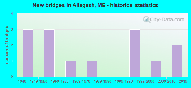
- New bridges - historical statistics
- 31940-1949
- 31950-1959
- 11960-1969
- 11970-1979
- 31990-1999
- 12000-2009
- 22010-2019
FCC Registered Antenna Towers:
5- Robert Parsloe, Us Route 161 (Lat: 47.100528 Lon: -68.967444), Type: 59.7, Structure height: 23003 m, Overall height: 57.9 m, Registrant: Rising Tide Towers LLC, Rparsloe@wireless-Partnersllc.Com, , Portl-and, Phone: (207) 808-5000
- Robert Parsloe, Us Route 161 (Lat: 47.100528 Lon: -68.967444), Type: 59.7, Structure height: 23003 m, Overall height: 57.9 m, Registrant: Rising Tide Towers LLC, Rparsloe@wireless-Partnersllc.Com, , Portl-and, Phone: (207) 808-5000
- Robert Parsloe, Us Route 161 (Lat: 47.100528 Lon: -68.967444), Type: 59.7, Structure height: 23003 m, Overall height: 57.9 m, Registrant: Rising Tide Towers LLC, Rparsloe@wireless-Partnersllc.Com, , Portl-and, Phone: (207) 808-5000
- Robert Parsloe, Us Route 161 (Lat: 47.100528 Lon: -68.967444), Type: 59.7, Structure height: 23003 m, Overall height: 57.9 m, Registrant: Rising Tide Towers LLC, Rparsloe@wireless-Partnersllc.Com, , Portl-and, Phone: (207) 808-5000
- Edward G Roach, Us Route 161 (Lat: 47.100528 Lon: -68.967444), Type: 59.7, Structure height: 23003 m, Overall height: 57.9 m, Registrant: Sba Towers Xi, LLC, Eroach@sbasite.Com, , Boca -Raton, Phone: (561) 995-7670
FCC Registered Amateur Radio Licenses:
3- Call Sign: AC1JE, Previous Call Sign: AC1IA, Licensee ID: L02163922, Grant Date: 04/17/2018, Expiration Date: 04/17/2028, Cancellation Date: 08/25/2020, Certifier: Jeremy J Mcbreairty, Registrant: Jeremy J Mcbreairty, 912 Allagash Rd Apt 4, Allagash, ME 04774
- Call Sign: AC1LZ, Previous Call Sign: AC1JZ, Licensee ID: L02163922, Grant Date: 04/17/2018, Expiration Date: 04/17/2028, Cancellation Date: 05/17/2023, Certifier: Jeremy J Mcbreairty, Registrant: Jeremy J Mcbreairty, 912 Allagash Rd Unit A1, Allagash, ME 04774
- Call Sign: AC1PG, Previous Call Sign: AC1LZ, Licensee ID: L02163922, Grant Date: 04/17/2018, Expiration Date: 04/17/2028, Certifier: Jeremy J Mcbreairty, Registrant: Jeremy J Mcbreairty, 912 Allagash Rd Unit A1, Allagash, ME 04774
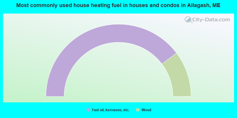
- 79.5%Fuel oil, kerosene, etc.
- 20.5%Wood
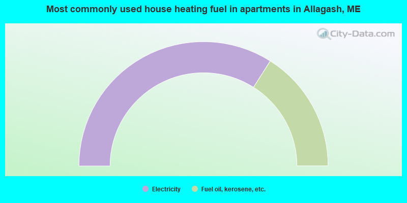
- 68.0%Electricity
- 32.0%Fuel oil, kerosene, etc.
Allagash compared to Maine state average:
- Median household income below state average.
- Median house value significantly below state average.
- Black race population percentage significantly below state average.
- Hispanic race population percentage below state average.
- Median age significantly above state average.
- Foreign-born population percentage significantly below state average.
- Length of stay since moving in significantly above state average.
- Number of rooms per house significantly below state average.
- House age significantly below state average.
- Percentage of population with a bachelor's degree or higher below state average.