Altamaha River, Georgia
Submit your own pictures of this place and show them to the world
- OSM Map
- General Map
- Google Map
- MSN Map

| Males: 1,483 | |
| Females: 1,481 |
| Median resident age: | 35.9 years |
| Georgia median age: | 33.4 years |
Zip code: 31513
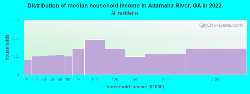
| Altamaha River: | $43,999 |
| GA: | $72,837 |
Estimated per capita income in 2022: $24,041 (it was $14,894 in 2000)
Altamaha River CCD income, earnings, and wages data
Estimated median house or condo value in 2022: $106,618 (it was $51,100 in 2000)
| Altamaha River: | $106,618 |
| GA: | $297,400 |
Mean prices in 2022: all housing units: $145,540; detached houses: $168,749; townhouses or other attached units: $199,563; mobile homes: $91,533
Altamaha River, GA residents, houses, and apartments details
Detailed information about poverty and poor residents in Altamaha River, GA


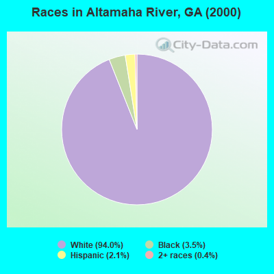
- 2,70894.0%White alone
- 1013.5%Black alone
- 602.1%Hispanic
- 110.4%Two or more races
- 10.03%American Indian alone
- 10.03%Other race alone
Races in Altamaha River detailed stats: ancestries, foreign born residents, place of birth
 Recent articles from our blog. Our writers, many of them Ph.D. graduates or candidates, create easy-to-read articles on a wide variety of topics.
Current Local Time: EST time zone
Land area: 125.3 square miles.
Population density: 24 people per square mile (very low).

| Altamaha River CCD: | 0.8% ($391) |
| Georgia: | 0.9% ($919) |
Nearest city with pop. 50,000+: Savannah, GA  (69.2 miles , pop. 131,510).
Nearest city with pop. 200,000+: Jacksonville, FL (113.2 miles , pop. 735,617).
Nearest city with pop. 1,000,000+: Philadelphia, PA (688.6 miles , pop. 1,517,550).
Nearest cities:
), ), )Latitude: 31.87 N, Longitude: 82.26 W
Area code commonly used in this area: 912

| Here: | 3.0% |
| Georgia: | 2.9% |
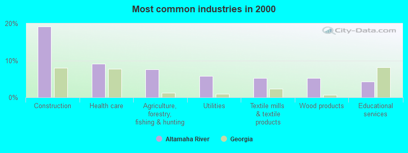
- Construction (19.2%)
- Health care (9.1%)
- Agriculture, forestry, fishing & hunting (7.6%)
- Utilities (5.9%)
- Textile mills & textile products (5.2%)
- Wood products (5.2%)
- Educational services (4.3%)
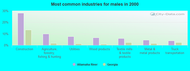
- Construction (28.2%)
- Agriculture, forestry, fishing & hunting (9.9%)
- Utilities (7.7%)
- Wood products (6.7%)
- Textile mills & textile products (5.9%)
- Metal & metal products (4.6%)
- Truck transportation (4.0%)
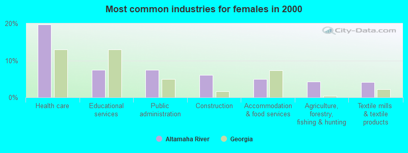
- Health care (19.7%)
- Educational services (7.4%)
- Public administration (7.4%)
- Construction (6.1%)
- Accommodation & food services (5.0%)
- Agriculture, forestry, fishing & hunting (4.3%)
- Textile mills & textile products (4.1%)
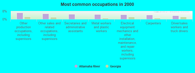
- Other production occupations, including supervisors (6.6%)
- Other sales and related occupations, including supervisors (5.5%)
- Secretaries and administrative assistants (5.1%)
- Metal workers and plastic workers (4.9%)
- Electrical equipment mechanics and other installation, maintenance, and repair workers, including supervisors (4.6%)
- Carpenters (4.3%)
- Driver/sales workers and truck drivers (3.7%)
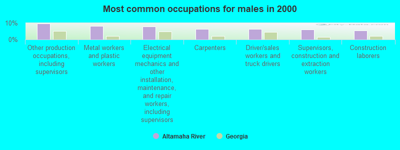
- Other production occupations, including supervisors (9.8%)
- Metal workers and plastic workers (8.2%)
- Electrical equipment mechanics and other installation, maintenance, and repair workers, including supervisors (7.9%)
- Carpenters (6.4%)
- Driver/sales workers and truck drivers (6.3%)
- Supervisors, construction and extraction workers (5.9%)
- Construction laborers (5.5%)

- Secretaries and administrative assistants (11.3%)
- Other sales and related occupations, including supervisors (6.7%)
- Registered nurses (5.0%)
- Financial clerks, except bookkeeping, accounting and auditing clerks (5.0%)
- Information and record clerks, except customer service representatives (4.8%)
- Laborers and material movers, hand (4.8%)
- Other management occupations, except farmers and farm managers (3.3%)
Average climate in Altamaha River, Georgia
Based on data reported by over 4,000 weather stations


Tornado activity:
Altamaha River-area historical tornado activity is below Georgia state average. It is 13% smaller than the overall U.S. average.
On 5/11/2008, a category F3 (max. wind speeds 158-206 mph) tornado 28.2 miles away from the Altamaha River place center injured 2 people and caused $1 million in damages.
On 4/8/1957, a category F3 tornado 33.2 miles away from the place center killed one person and injured 3 people and caused between $5000 and $50,000 in damages.
Earthquake activity:
Altamaha River-area historical earthquake activity is significantly above Georgia state average. It is 36% smaller than the overall U.S. average.On 8/2/1974 at 08:52:09, a magnitude 4.9 (4.3 MB, 4.9 LG, Class: Light, Intensity: IV - V) earthquake occurred 138.9 miles away from the city center
On 11/22/1974 at 05:25:55, a magnitude 4.7 (4.7 MB) earthquake occurred 142.8 miles away from Altamaha River center
On 8/21/1992 at 16:31:55, a magnitude 4.4 (4.1 MB, 4.1 LG, 4.4 LG, Depth: 6.2 mi) earthquake occurred 149.5 miles away from the city center
On 4/29/2003 at 08:59:39, a magnitude 4.9 (4.4 MB, 4.6 MW, 4.9 LG) earthquake occurred 266.1 miles away from the city center
On 7/13/2003 at 20:15:16, a magnitude 3.6 (3.6 MB, Depth: 3.1 mi, Class: Light, Intensity: II - III) earthquake occurred 32.8 miles away from Altamaha River center
On 2/15/2014 at 03:23:38, a magnitude 4.1 (4.1 MW, Depth: 3.2 mi) earthquake occurred 134.9 miles away from the city center
Magnitude types: regional Lg-wave magnitude (LG), body-wave magnitude (MB), moment magnitude (MW)
Natural disasters:
The number of natural disasters in Appling County (11) is smaller than the US average (15).Major Disasters (Presidential) Declared: 5
Emergencies Declared: 4
Causes of natural disasters: Storms: 4, Floods: 3, Hurricanes: 3, Tornadoes: 3, Winds: 2, Drought: 1, Snowfall: 1, Tropical Storm: 1, Winter Storm: 1, Other: 1 (Note: some incidents may be assigned to more than one category).
Hospitals and medical centers near Altamaha River:
- ALTAMAHA HOMECARE, INC (Home Health Center, about 9 miles away; BAXLEY, GA)
- BAXLEY DIALYSIS (Dialysis Facility, about 9 miles away; BAXLEY, GA)
- APPLING HOSPITAL Acute Care Hospitals (about 9 miles away; BAXLEY, GA)
- APPLING NURSING AND REHABILITATION PAVILION (Nursing Home, about 9 miles away; BAXLEY, GA)
Operable nuclear power plants near Altamaha River:
- 9 miles: Edwin I. Hatch 1 and 2 in Baxley, GA.
Colleges/universities with over 2000 students nearest to Altamaha River:
- South Georgia State College (about 44 miles; Douglas, GA; Full-time enrollment: 2,507)
- Georgia Southern University (about 48 miles; Statesboro, GA; FT enrollment: 18,824)
- East Georgia State College (about 51 miles; Swainsboro, GA; FT enrollment: 2,345)
- Armstrong Atlantic State University (about 66 miles; Savannah, GA; FT enrollment: 6,399)
- Savannah Technical College (about 69 miles; Savannah, GA; FT enrollment: 3,677)
- College of Coastal Georgia (about 69 miles; Brunswick, GA; FT enrollment: 2,447)
- South University–Savannah Online (about 69 miles; Savannah, GA; FT enrollment: 13,512)
Points of interest:
Notable locations in Altamaha River: Hatch Nuclear Power Plant (A), Deens Landing (B), Carters Bight Landing (C), Davis Landing (D), Lower Sister Bluff Landing (E), Appling County Fire Department Altamaha Station (F), Appling County Fire Department Ten Mile Station (G), Appling County Fire Department Highway 144 Station (H), Georgia Power Plant Hatch (I), Highway 144 Fire Substation (J). Display/hide their locations on the map
Churches in Altamaha River include: Altamaha Church (A), Bethel United Methodist Church (B), Riverside Missionary Baptist Church (C), Spring Branch Baptist Church (D), Blantons Chapel (E), Zion Missionary Baptist Church (F), Oak Grove Church of God (G), Meltons Chapel United Methodist Church (H), Midway Missionary Baptist Church (I). Display/hide their locations on the map
Cemeteries: Appling Memorial Cemetery (1), Bell Cemetery (2), Benton Cemetery (3), Mann Cemetery (4), Sellers Cemetery (5), Carter Cemetery (6), Moody Cemetery (7). Display/hide their locations on the map
Reservoirs and swamps: Eason Lake (A), Lewis Lake (B), Big Pond (C). Display/hide their locations on the map
Creeks: Tenmile Creek (A), Roaring Creek (B), Bay Creek (C). Display/hide their locations on the map
| This place: | 2.5 people |
| Georgia: | 2.6 people |
| This place: | 71.7% |
| Whole state: | 68.5% |
| This place: | 4.8% |
| Whole state: | 5.9% |
Likely homosexual households (counted as self-reported same-sex unmarried-partner households)
- Lesbian couples: 0.3% of all households
- Gay men: 0.2% of all households
| This place: | 12.4% |
| Whole state: | 13.0% |
| This place: | 2.9% |
| Whole state: | 6.1% |
People in group quarters in Altamaha River in 2000:
- 12 people in short-term care, detention or diagnostic centers for delinquent children
- 9 people in training schools for juvenile delinquents
- 6 people in nursing homes
For population 15 years and over in Altamaha River:
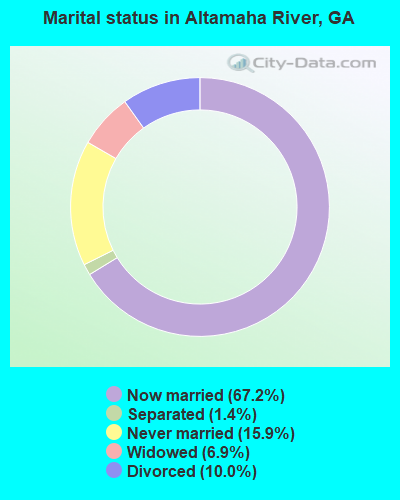
- Never married: 15.9%
- Now married: 67.2%
- Separated: 1.4%
- Widowed: 6.9%
- Divorced: 10.0%
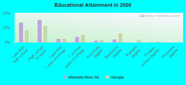
For population 25 years and over in Altamaha River:
- High school or higher: 65.3%
- Bachelor's degree or higher: 7.2%
- Graduate or professional degree: 2.0%
- Unemployed: 3.5%
- Mean travel time to work (commute): 26.7 minutes
| Here: | 11.7 |
| Georgia average: | 13.3 |
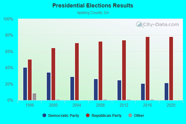


Graphs represent county-level data. Detailed 2008 Election Results
Religion statistics for Altamaha River, GA (based on Appling County data)
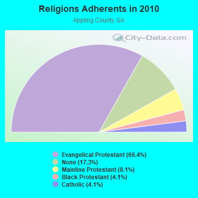
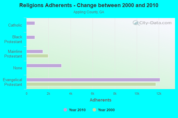
| Religion | Adherents | Congregations |
|---|---|---|
| Evangelical Protestant | 12,109 | 46 |
| Mainline Protestant | 1,472 | 10 |
| Black Protestant | 751 | 5 |
| Catholic | 742 | 1 |
| Other | 1 | 1 |
| None | 3,161 | - |
Food Environment Statistics:
| Appling County: | 1.12 / 10,000 pop. |
| Georgia: | 1.91 / 10,000 pop. |
| This county: | 0.56 / 10,000 pop. |
| State: | 0.15 / 10,000 pop. |
| Appling County: | 1.12 / 10,000 pop. |
| Georgia: | 0.86 / 10,000 pop. |
| Appling County: | 7.26 / 10,000 pop. |
| State: | 5.12 / 10,000 pop. |
| Here: | 8.38 / 10,000 pop. |
| State: | 7.41 / 10,000 pop. |
| This county: | 10.9% |
| Georgia: | 10.4% |
| Appling County: | 30.2% |
| Georgia: | 27.8% |
| This county: | 11.2% |
| State: | 14.6% |
Strongest AM radio stations in Altamaha River:
- WUFE (1260 AM; daytime; 5 kW; BAXLEY, GA; Owner: SOUTH GEORGIA BROADCASTERS, INC.)
- WVOP (970 AM; 5 kW; VIDALIA, GA; Owner: VIDALIA COMMUNICATIONS CORPORATION)
- WOKV (690 AM; 50 kW; JACKSONVILLE, FL; Owner: COX RADIO, INC.)
- WLOP (1370 AM; 5 kW; JESUP, GA; Owner: JESUP BROADCASTING CORP.)
- WMAC (940 AM; 50 kW; MACON, GA; Owner: CUMULUS LICENSING CORP.)
- WFVR (910 AM; 50 kW; VALDOSTA, GA; Owner: RAMA COMMUNICATIONS, INC.)
- WDMG (860 AM; 5 kW; DOUGLAS, GA; Owner: RTG RADIO, LLC)
- WOBS (1530 AM; daytime; 50 kW; JACKSONVILLE, FL; Owner: WORD BROADCASTING NETWORK, INC.)
- WGSR (1570 AM; 50 kW; FERNANDINA BEACH, FL; Owner: RJM COMMUNICATIONS, INC)
- WGST (640 AM; 50 kW; ATLANTA, GA; Owner: CITICASTERS LICENSES, L.P.)
- WCGA (1100 AM; daytime; 10 kW; WOODBINE, GA; Owner: COX BROADCAST GROUP, INC.)
- WCNN (680 AM; 50 kW; NORTH ATLANTA, GA; Owner: DICKEY BROADCASTING COMPANY)
- WSB (750 AM; 50 kW; ATLANTA, GA; Owner: CXR HOLDINGS, INC.)
Strongest FM radio stations in Altamaha River:
- WBYZ (94.5 FM; BAXLEY, GA; Owner: SOUTH GEORGIA BROADCASTERS, INC.)
- WLPT (88.3 FM; JESUP, GA; Owner: AUGUSTA RADIO FELLOWSHIP INSTITUTE, INC.)
- WRBX (104.1 FM; REIDSVILLE, GA; Owner: WRBX / WTNL, INC.)
- WOKA-FM (106.7 FM; DOUGLAS, GA; Owner: COFFEE COUNTY BROADCASTERS, INC.)
- WWSN (103.3 FM; WAYCROSS, GA; Owner: QANTUM OF BRUNSWICK LICENSE COMPANY, LLC)
- WVOH-FM (93.5 FM; HAZLEHURST, GA; Owner: JEFF DAVIS BROADCASTERS, INC.)
- WLYU (100.9 FM; LYONS, GA; Owner: T.C.B. BROADCASTING INC)
- WGPH (91.5 FM; VIDALIA, GA; Owner: AUGUSTA RADIO FELLOWSHIP INSTITUTE,)
- WCGN (106.3 FM; GLENNVILLE, GA; Owner: BULLIE BROADCASTING CORPORATION)
- WYUM (101.7 FM; MOUNT VERNON, GA; Owner: VIDALIA COMMUNICATIONS CORPORATION)
- WAJQ-FM (104.3 FM; ALMA, GA; Owner: BLUEBERRY BROADCASTING COMPANY, INC.)
- WTCQ (97.7 FM; VIDALIA, GA; Owner: VIDALIA COMMUNICATIONS CORPORATION)
TV broadcast stations around Altamaha River:
- WGSA (Channel 34; BAXLEY, GA; Owner: SOUTHERN TV CORPORATION)
- WPXC-TV (Channel 21; BRUNSWICK, GA; Owner: PAXSON JAX LICENSE, INC.)
- WVAN-TV (Channel 9; SAVANNAH, GA; Owner: GEORGIA PUBLIC TELECOMMUNICATIONS COMMISSION)
- WPHJ-CA (Channel 46; VIDALIA, GA; Owner: BARINOWSKI INVESTMENT COMPANY, L.P.)
- W56DU (Channel 56; HAZLEHURST, GA; Owner: JEFF DAVIS BROADCASTERS, INC.)
- W39BV (Channel 39; HINESVILLE-RICHMOND, GA; Owner: SOUTHERN TV CORPORATION)
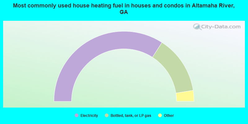
- 68.3%Electricity
- 26.8%Bottled, tank, or LP gas
- 3.5%Wood
- 1.0%Utility gas
- 0.4%Fuel oil, kerosene, etc.
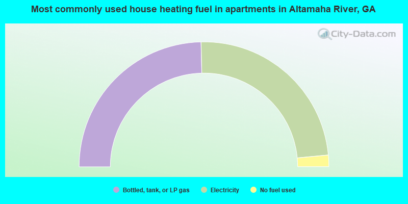
- 49.3%Bottled, tank, or LP gas
- 47.8%Electricity
- 3.0%No fuel used
Altamaha River compared to Georgia state average:
- Median household income below state average.
- Median house value significantly below state average.
- Unemployed percentage significantly below state average.
- Black race population percentage significantly below state average.
- Hispanic race population percentage significantly below state average.
- Foreign-born population percentage significantly below state average.
- Renting percentage below state average.
- Length of stay since moving in significantly above state average.
- Number of rooms per house significantly below state average.
- House age significantly below state average.
- Number of college students below state average.
- Percentage of population with a bachelor's degree or higher significantly below state average.
Altamaha River on our top lists:
- #64 on the list of "Top 101 cities with the largest percentage of people in short-term care, detention or diagnostic centers for delinquent children (population 1,000+)"