Anderson, Wisconsin
Submit your own pictures of this town and show them to the world
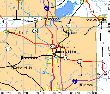
- OSM Map
- General Map
- Google Map
- MSN Map
Population change since 2000: +7.0%
 |
| Males: 213 | |
| Females: 185 |
| Median resident age: | 44.5 years |
| Wisconsin median age: | 42.6 years |
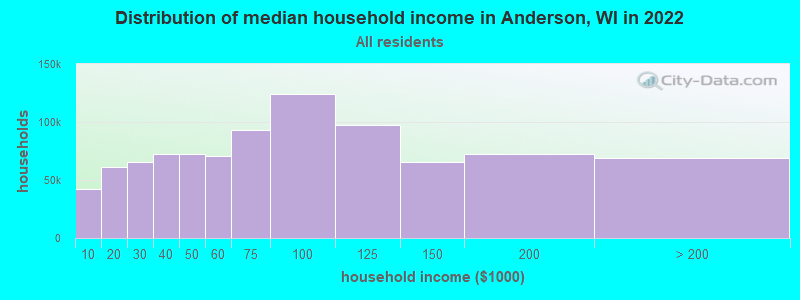
| Anderson: | $55,091 |
| WI: | $70,996 |
Estimated per capita income in 2022: $34,939 (it was $17,013 in 2000)
Anderson town income, earnings, and wages data
Estimated median house or condo value in 2022: $166,597 (it was $64,400 in 2000)
| Anderson: | $166,597 |
| WI: | $252,800 |
Detailed information about poverty and poor residents in Anderson, WI


- 39298.5%White alone
- 41.0%Two or more races
- 10.3%Black alone
- 10.3%Hispanic
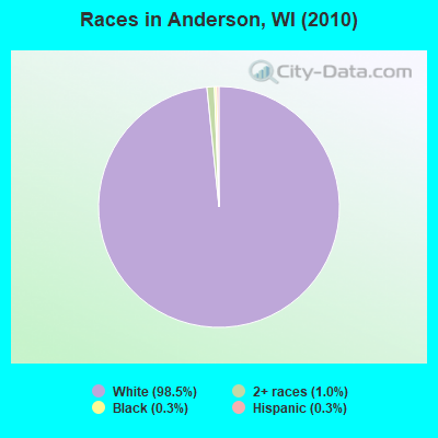
Races in Anderson detailed stats: ancestries, foreign born residents, place of birth
 Recent articles from our blog. Our writers, many of them Ph.D. graduates or candidates, create easy-to-read articles on a wide variety of topics.

 | No "loss leaders" in WI = HIGHER FOOD PRICES (39 replies) |
| Brown Deer Road (29 replies) |
| Where to live in the Green Bay area? (3 replies) |
| is the Mayfair Mall incident a warning for the future? (273 replies) |
| Possible job opportunity in Great Lakes, IL - living in Wisconsin (17 replies) |
| Where is the good place to live, KY/OH or WI/MN? (16 replies) |
Latest news from Anderson, WI collected exclusively by city-data.com from local newspapers, TV, and radio stations
Ancestries: German (48.4%), Swedish (28.5%), Norwegian (23.9%), Irish (11.6%), Polish (8.6%), English (5.6%).
Current Local Time: CST time zone
Elevation: 870 feet
Land area: 62.8 square miles.
Population density: 6.3 people per square mile (very low).
4 residents are foreign born
| This town: | 1.1% |
| Wisconsin: | 3.6% |
| Anderson town: | 1.0% ($660) |
| Wisconsin: | 2.0% ($2,245) |
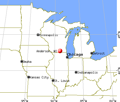
Nearest city with pop. 50,000+: Coon Rapids, MN  (44.6 miles , pop. 61,607).
Nearest city with pop. 200,000+: St. Paul, MN (53.3 miles , pop. 287,151).
Nearest city with pop. 1,000,000+: Chicago, IL (366.7 miles , pop. 2,896,016).
Nearest cities:
), ), ), ), )Latitude: 45.68 N, Longitude: 92.74 W
Area code commonly used in this area: 715

| Here: | 4.6% |
| Wisconsin: | 2.7% |
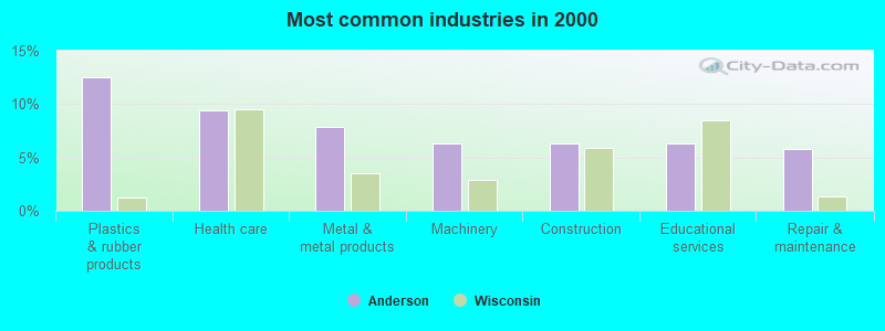
- Plastics & rubber products (12.6%)
- Health care (9.4%)
- Metal & metal products (7.9%)
- Machinery (6.3%)
- Construction (6.3%)
- Educational services (6.3%)
- Repair & maintenance (5.8%)
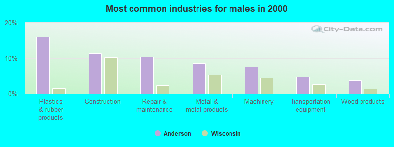
- Plastics & rubber products (16.0%)
- Construction (11.3%)
- Repair & maintenance (10.4%)
- Metal & metal products (8.5%)
- Machinery (7.5%)
- Transportation equipment (4.7%)
- Wood products (3.8%)
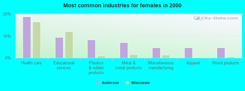
- Health care (18.8%)
- Educational services (9.4%)
- Plastics & rubber products (8.2%)
- Metal & metal products (7.1%)
- Miscellaneous manufacturing (4.7%)
- Apparel (4.7%)
- Wood products (4.7%)
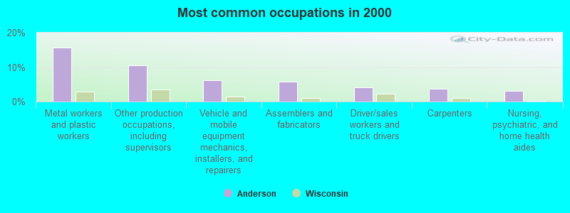
- Metal workers and plastic workers (15.7%)
- Other production occupations, including supervisors (10.5%)
- Vehicle and mobile equipment mechanics, installers, and repairers (6.3%)
- Assemblers and fabricators (5.8%)
- Driver/sales workers and truck drivers (4.2%)
- Carpenters (3.7%)
- Nursing, psychiatric, and home health aides (3.1%)
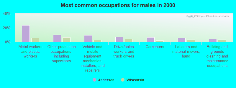
- Metal workers and plastic workers (23.6%)
- Other production occupations, including supervisors (10.4%)
- Vehicle and mobile equipment mechanics, installers, and repairers (9.4%)
- Driver/sales workers and truck drivers (7.5%)
- Carpenters (6.6%)
- Laborers and material movers, hand (5.7%)
- Building and grounds cleaning and maintenance occupations (4.7%)
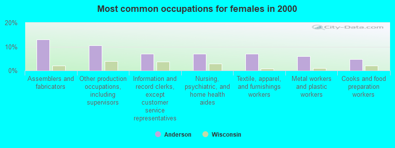
- Assemblers and fabricators (12.9%)
- Other production occupations, including supervisors (10.6%)
- Information and record clerks, except customer service representatives (7.1%)
- Nursing, psychiatric, and home health aides (7.1%)
- Textile, apparel, and furnishings workers (7.1%)
- Metal workers and plastic workers (5.9%)
- Cooks and food preparation workers (4.7%)
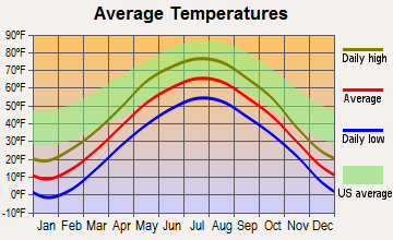
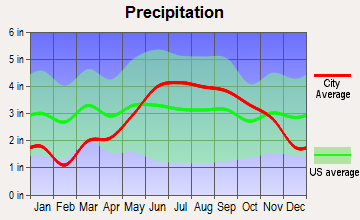
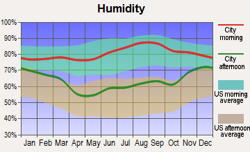
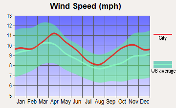
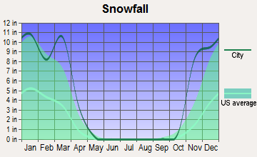
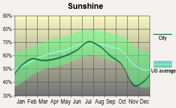
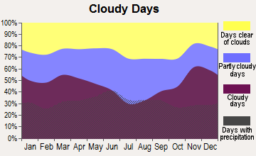
Average climate in Anderson, Wisconsin
Based on data reported by over 4,000 weather stations
(lower is better)
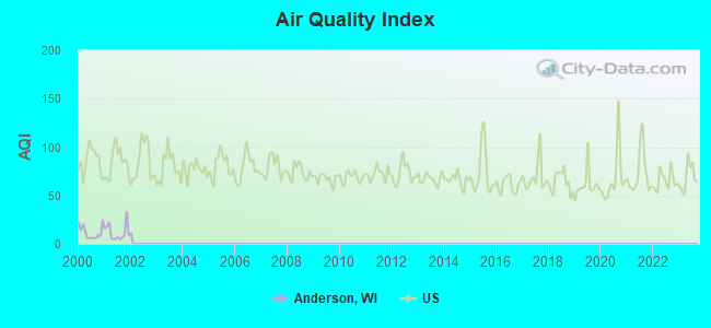
Air Quality Index (AQI) level in 2001 was 11.9. This is significantly better than average.
| City: | 11.9 |
| U.S.: | 72.6 |
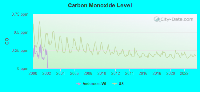
Carbon Monoxide (CO) [ppm] level in 2001 was 0.194. This is better than average. Closest monitor was 19.9 miles away from the city center.
| City: | 0.194 |
| U.S.: | 0.251 |
Tornado activity:
Anderson-area historical tornado activity is slightly below Wisconsin state average. It is 9% smaller than the overall U.S. average.
On 5/21/1957, a category F4 (max. wind speeds 207-260 mph) tornado 6.7 miles away from the Anderson town center injured 2 people and caused between $5000 and $50,000 in damages.
On 6/18/2001, a category F3 (max. wind speeds 158-206 mph) tornado 8.3 miles away from the town center killed 2 people and injured 16 people and caused $10 million in damages.
Earthquake activity:
Anderson-area historical earthquake activity is significantly above Wisconsin state average. It is 60% smaller than the overall U.S. average.On 7/9/1975 at 14:54:15, a magnitude 4.6 (4.6 MB, Class: Light, Intensity: IV - V) earthquake occurred 159.3 miles away from the city center
On 6/5/1993 at 01:24:53, a magnitude 4.1 (4.1 LG, Depth: 6.2 mi) earthquake occurred 171.5 miles away from the city center
On 3/4/1983 at 06:32:18, a magnitude 4.6 (4.4 MB, 4.6 LG, 4.4 ML) earthquake occurred 341.5 miles away from Anderson center
On 2/7/2020 at 18:30:28, a magnitude 3.3 (3.3 ML, Class: Light, Intensity: II - III) earthquake occurred 124.4 miles away from Anderson center
On 10/20/1995 at 15:57:18, a magnitude 3.7 (3.7 LG, Depth: 3.1 mi) earthquake occurred 199.0 miles away from the city center
On 1/9/2020 at 18:16:48, a magnitude 3.3 (3.3 MB) earthquake occurred 129.2 miles away from Anderson center
Magnitude types: regional Lg-wave magnitude (LG), body-wave magnitude (MB), local magnitude (ML)
Natural disasters:
The number of natural disasters in Burnett County (9) is smaller than the US average (15).Major Disasters (Presidential) Declared: 6
Emergencies Declared: 3
Causes of natural disasters: Floods: 5, Storms: 4, Tornadoes: 2, Winds: 2, Drought: 1, Hurricane: 1, Other: 1 (Note: some incidents may be assigned to more than one category).
Hospitals and medical centers near Anderson:
- GOLDEN LIVINGCENTER - RUSH CITY (Nursing Home, about 11 miles away; RUSH CITY, MN)
- HILLCREST HEALTH CARE CENTER (Nursing Home, about 11 miles away; RUSH CITY, MN)
- RUSH CITY HOSPITAL (Hospital, about 12 miles away; RUSH CITY, MN)
- FREDERIC NUR REHAB COM (Nursing Home, about 14 miles away; FREDERIC, WI)
- PINE CITY DIALYSIS OF DAVITA (Dialysis Facility, about 15 miles away; PINE CITY, MN)
- LAKESIDE MEDICAL CENTER (Nursing Home, about 16 miles away; PINE CITY, MN)
- CHISAGO CO PUBLIC HEALTH DEPT (Home Health Center, about 16 miles away; NORTH BRANCH, MN)
Colleges/universities with over 2000 students nearest to Anderson:
- Wisconsin Indianhead Technical College (about 41 miles; Shell Lake, WI; Full-time enrollment: 2,414)
- Century College (about 46 miles; White Bear Lake, MN; FT enrollment: 7,393)
- Anoka-Ramsey Community College (about 46 miles; Coon Rapids, MN; FT enrollment: 5,918)
- Bethel University (about 48 miles; Saint Paul, MN; FT enrollment: 4,061)
- University of Northwestern-St Paul (about 50 miles; Saint Paul, MN; FT enrollment: 2,680)
- North Hennepin Community College (about 51 miles; Brooklyn Park, MN; FT enrollment: 4,943)
- Hennepin Technical College (about 52 miles; Brooklyn Park, MN; FT enrollment: 4,515)
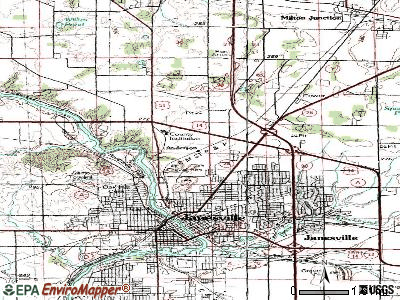
Points of interest:
Notable location: Anderson Townhall (A). Display/hide its location on the map
Churches in Anderson include: Pleasant Prairie Church (A), Bethany Church (B). Display/hide their locations on the map
Cemeteries: Logging Creek Cemetery (1), Saint Olaf Cemetery (2). Display/hide their locations on the map
Lakes and reservoirs: Little Holmes Lake (A), Canute Creek Flowage (B), County Trunk O Flowage (C), Logging Creek Flowage 6 (D), Daniels Flowage (E), Dueholm Flowage (F). Display/hide their locations on the map
River: North Fork Trade River (A). Display/hide its location on the map
Parks in Anderson include: Fish Lake Meadow State Natural Area (1), Fish Lake Pines State Natural Area (2), Saint Croix Seeps State Natural Area (3), Fish Lake State Wildlife Area (4). Display/hide their locations on the map
| This town: | 2.4 people |
| Wisconsin: | 2.4 people |
| This town: | 68.5% |
| Whole state: | 64.4% |
| This town: | 12.1% |
| Whole state: | 7.3% |
Likely homosexual households (counted as self-reported same-sex unmarried-partner households)
- Lesbian couples: 0.0% of all households
- Gay men: 1.2% of all households
| This town: | 7.7% |
| Whole state: | 8.7% |
| This town: | 3.4% |
| Whole state: | 3.7% |
For population 15 years and over in Anderson:
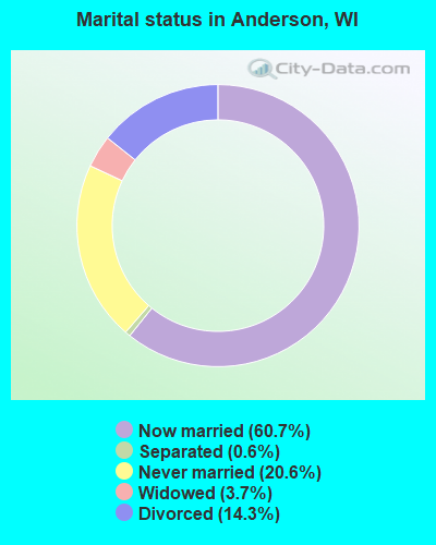
- Never married: 20.6%
- Now married: 60.7%
- Separated: 0.6%
- Widowed: 3.7%
- Divorced: 14.3%
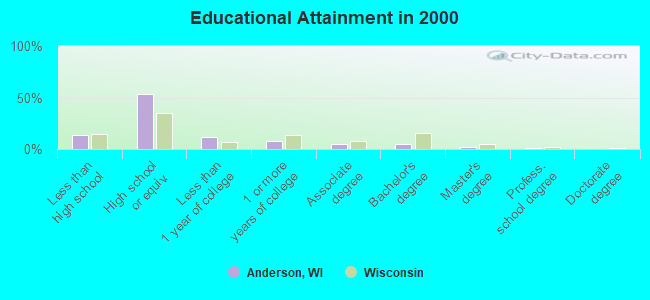
For population 25 years and over in Anderson:
- High school or higher: 86.3%
- Bachelor's degree or higher: 8.3%
- Graduate or professional degree: 3.3%
- Unemployed: 7.7%
- Mean travel time to work (commute): 36.0 minutes
| Here: | 7.8 |
| Wisconsin average: | 11.0 |
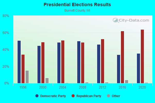
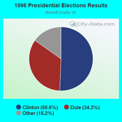
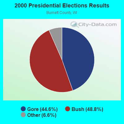
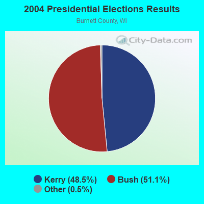
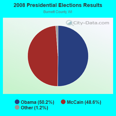
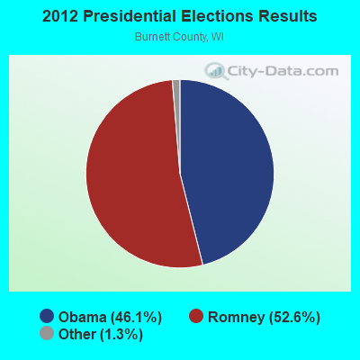
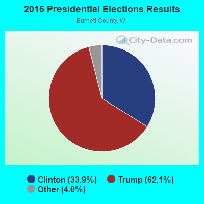
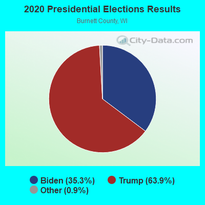
Graphs represent county-level data. Detailed 2008 Election Results
Religion statistics for Anderson, WI (based on Burnett County data)
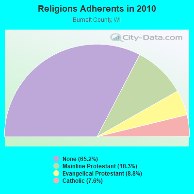
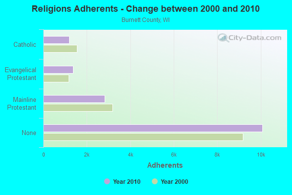
| Religion | Adherents | Congregations |
|---|---|---|
| Mainline Protestant | 2,829 | 13 |
| Evangelical Protestant | 1,361 | 14 |
| Catholic | 1,181 | 4 |
| Other | 1 | 1 |
| None | 10,085 | - |
Food Environment Statistics:
| Burnett County: | 3.68 / 10,000 pop. |
| Wisconsin: | 1.86 / 10,000 pop. |
| Here: | 0.61 / 10,000 pop. |
| State: | 0.38 / 10,000 pop. |
| This county: | 4.91 / 10,000 pop. |
| State: | 4.12 / 10,000 pop. |
| Here: | 16.58 / 10,000 pop. |
| Wisconsin: | 8.64 / 10,000 pop. |
| Burnett County: | 9.8% |
| State: | 7.6% |
| Here: | 28.3% |
| Wisconsin: | 27.5% |
| Burnett County: | 14.0% |
| Wisconsin: | 13.0% |
Strongest AM radio stations in Anderson:
- WCCO (830 AM; 50 kW; MINNEAPOLIS, MN; Owner: INFINITY MEDIA CORPORATION)
- KSTP (1500 AM; 50 kW; ST. PAUL, MN; Owner: KSTP-AM, LLC (DELAWARE))
- WCTS (1030 AM; 50 kW; MAPLEWOOD, MN; Owner: CNTL. BAPT. THEO/AL SEMI MINNEAPOLIS)
- WEBC (560 AM; 50 kW; DULUTH, MN)
- KTIS (900 AM; 25 kW; MINNEAPOLIS, MN; Owner: NORTHWESTERN COLLEGE)
- KFAN (1130 AM; 50 kW; MINNEAPOLIS, MN; Owner: AMFM RADIO LICENSES, L.L.C.)
- WDGY (630 AM; 8 kW; HUDSON, WI; Owner: 630 RADIO, INCORPORATED)
- WXCE (1260 AM; 5 kW; AMERY, WI; Owner: LAKE COUNTRY BROADCASTING CORPORATION)
- WBHR (660 AM; 10 kW; SAUK RAPIDS, MN; Owner: HERBERT M. HOPPE)
- WCMP (1350 AM; 1 kW; PINE CITY, MN; Owner: QUEST BROADCASTING, INC.)
- WDSM (710 AM; 10 kW; SUPERIOR, WI; Owner: MIDWEST COMMUNICATIONS, INC.)
- KUOM (770 AM; daytime; 5 kW; MINNEAPOLIS, MN)
- WWJC (850 AM; daytime; 10 kW; DULUTH, MN; Owner: WWJC, INC.)
Strongest FM radio stations in Anderson:
- WXPT (104.1 FM; ST. LOUIS PARK, MN; Owner: THE AUDIO HOUSE, INC.)
- KNOW-FM (91.1 FM; MINNEAPOLIS-ST. PAUL, MN; Owner: MINNESOTA PUBLIC RADIO)
- KJZI (100.3 FM; MINNEAPOLIS, MN; Owner: AMFM RADIO LICENSES, L.L.C.)
- WLTE (102.9 FM; MINNEAPOLIS, MN; Owner: INFINITY MEDIA CORPORATION)
- KSTP-FM (94.5 FM; ST. PAUL, MN; Owner: KSTP-FM, LLC, A DELAWARE LLC)
- WXCX (105.7 FM; SIREN, WI; Owner: QUARNSTROM MEDIA GROUP, LLC)
- KQQL (107.9 FM; ANOKA, MN; Owner: AMFM RADIO LICENSES, L.L.C.)
- KMKL (90.3 FM; NORTH BRANCH, MN; Owner: EDUCATIONAL MEDIA FOUNDATION)
- WGVY (105.3 FM; CAMBRIDGE, MN; Owner: KQRS, INC.)
- WCMP-FM (100.9 FM; PINE CITY, MN; Owner: QUARNSTROM MEDIA GROUP, LLC)
TV broadcast stations around Anderson:
- KMSP-TV (Channel 9; MINNEAPOLIS, MN; Owner: FOX TELEVISION STATIONS, INC.)
- KARE (Channel 11; MINNEAPOLIS, MN; Owner: MULTIMEDIA HOLDINGS CORPORATION)
- KSTP-TV (Channel 5; ST. PAUL, MN; Owner: HUBBARD BROADCASTING, INC.)
- KTCA-TV (Channel 2; ST. PAUL, MN; Owner: TWIN CITIES PUBLIC TELEVISION, INC.)
- W24CL (Channel 24; GRANTSBURG, WI; Owner: STATE OF WISCONSIN - EDUCATIONAL COMMUNICATIONS BOARD)
- WCCO-TV (Channel 4; MINNEAPOLIS, MN; Owner: CBS BROADCASTING INC.)
- KTCI-TV (Channel 17; ST. PAUL, MN; Owner: TWIN CITIES PUBLIC TELEVISION, INC.)
- KPXM (Channel 41; ST. CLOUD, MN; Owner: PAXSON MINNEAPOLIS LICENSE, INC.)
- KSTC-TV (Channel 45; MINNEAPOLIS, MN; Owner: HUBBARD BROADCASTING, INC.)
- KMWB (Channel 23; MINNEAPOLIS, MN; Owner: KLGT LICENSEE, LLC)
- WFTC (Channel 29; MINNEAPOLIS, MN; Owner: FOX TELEVISION STATIONS, INC.)
- National Bridge Inventory (NBI) Statistics
- 6Number of bridges
- 36ft / 11.5mTotal length
- 4,218Total average daily traffic
- 387Total average daily truck traffic
- 5,422Total future (year 2039) average daily traffic
FCC Registered Antenna Towers:
2- JULIE HEFFERNAN, County Line Rd Wi-5592 (Lat: 45.644028 Lon: -92.676917), Type: 86.8, Structure height: 55013 m, Overall height: 83.8 m, Registrant: Vertical Bridge Reit LLC, Fcc-Faa@verticalbridge.Com, Suite 200, 2796348 Boca -Raton, Phone: (561) 406-4015
- Matthew Bonfante, County Line Rd Wi-5592 (Lat: 45.644028 Lon: -92.676917), Type: 86.8, Structure height: 55013 m, Overall height: 83.8 m, Registrant: Vertical Bridge Reit LLC, Fcc-Faa@verticalbridge.Com, , Boca -Raton, Phone: (561) 406-4015
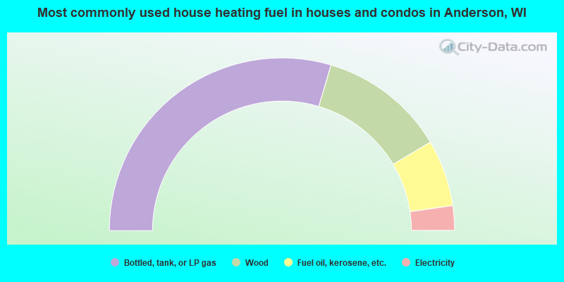
- 59.2%Bottled, tank, or LP gas
- 23.7%Wood
- 12.5%Fuel oil, kerosene, etc.
- 4.6%Electricity
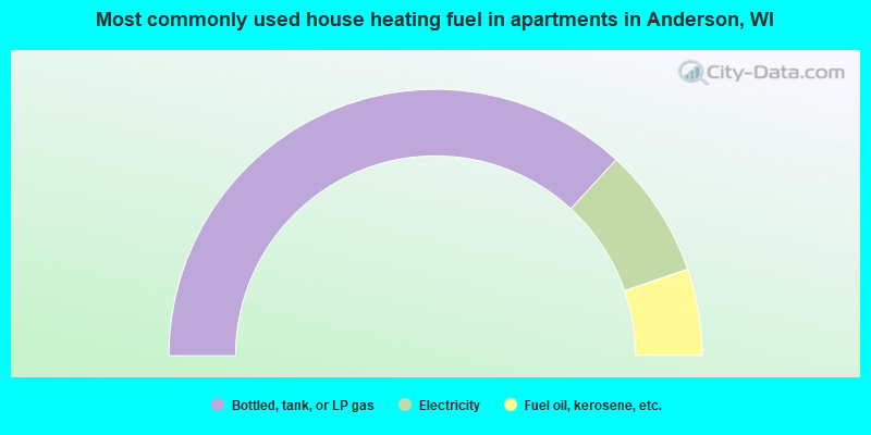
- 73.7%Bottled, tank, or LP gas
- 15.8%Electricity
- 10.5%Fuel oil, kerosene, etc.
Anderson compared to Wisconsin state average:
- Median house value below state average.
- Black race population percentage significantly below state average.
- Hispanic race population percentage significantly below state average.
- Foreign-born population percentage significantly below state average.
- Renting percentage significantly below state average.
- Length of stay since moving in significantly above state average.
- Number of rooms per house significantly below state average.
- House age significantly below state average.
- Number of college students significantly below state average.
- Percentage of population with a bachelor's degree or higher significantly below state average.