Ashers Fork, Kentucky
Submit your own pictures of this place and show them to the world
- OSM Map
- General Map
- Google Map
- MSN Map

| Males: 796 | |
| Females: 776 |
| Median resident age: | 33.4 years |
| Kentucky median age: | 35.9 years |
Zip code: 40962
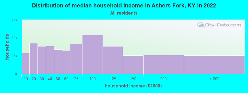
| Ashers Fork: | $36,247 |
| KY: | $59,341 |
Estimated per capita income in 2022: $15,237 (it was $7,458 in 2000)
Ashers Fork CCD income, earnings, and wages data
Estimated median house or condo value in 2022: $42,293 (it was $17,900 in 2000)
| Ashers Fork: | $42,293 |
| KY: | $196,300 |
Detailed information about poverty and poor residents in Ashers Fork, KY
Compare current foreclosures near Ashers Fork, KY:
| Photo | Address | Area | Beds / Baths | Price | Details |
|---|---|---|---|---|---|

|
#1
John Bailey Rd
Arjay, KY 40902
|
- sq. feet
|
- baths - beds |
$17,900
|
show details |

|
#2
Us-421
Manchester, KY 40962
|
1,424 sq. feet
|
1 baths 3 beds |
show details | |

|
#3
E Laurel Rd
London, KY 40741
|
2,290 sq. feet
|
2 baths 3 beds |
show details | |

|
#4
Peppermint Dr
Hyden, KY 41749
|
608 sq. feet
|
1 baths 1 beds |
show details | |

|
#5
Pawpaw Rd
Manchester, KY 40962
|
1,080 sq. feet
|
1 baths 3 beds |
show details | |

|
#6
Echo Ln
Thousandsticks, KY 41766
|
1,232 sq. feet
|
1 baths 3 beds |
show details | |

|
#7
S Highway 11
Manchester, KY 40962
|
1,416 sq. feet
|
1 baths 3 beds |
show details | |

|
#8
Highway 406
Stinnett, KY 40868
|
960 sq. feet
|
1 baths 3 beds |
show details | |

|
#9
Heavenly Dr
Wendover, KY 41775
|
2,520 sq. feet
|
3 baths 3 beds |
show details | |

|
#10
Highway 1524
Manchester, KY 40962
|
1,188 sq. feet
|
1 baths 3 beds |
show details |
| Photo | Address | Area | Beds / Baths | Price | Details |
|---|---|---|---|---|---|

|
#11
Crawfish Rd
Manchester, KY 40962
|
1,248 sq. feet
|
1 baths 3 beds |
show details | |

|
#12
Burly Hollow Rd
Manchester, KY 40962
|
1,248 sq. feet
|
- baths - beds |
show details | |

|
#13
Azelia Rd
Manchester, KY 40962
|
1,280 sq. feet
|
- baths - beds |
show details | |

|
#14
Ky 1304
Hinkle, KY 40953
|
- sq. feet
|
- baths - beds |
show details | |

|
#15
Merida Hollow Rd
Sizerock, KY 41762
|
- sq. feet
|
- baths - beds |
show details | |

|
#16
Jarve Hollow Rd
Manchester, KY 40962
|
- sq. feet
|
- baths - beds |
show details | |

|
#17
Mill Creek Rd
Kettle Island, KY 40958
|
- sq. feet
|
- baths - beds |
show details | |

|
#18
Black Gold Ln
Hyden, KY 41749
|
- sq. feet
|
- baths - beds |
show details | |

|
#19
Gregory Himes Ln
Barbourville, KY 40906
|
- sq. feet
|
- baths - beds |
show details | |

|
#20
W Highway 221
Bledsoe, KY 40810
|
- sq. feet
|
- baths - beds |
show details |
| Photo | Address | Area | Beds / Baths | Price | Details |
|---|---|---|---|---|---|

|
#21
Progress Rd
Bimble, KY 40915
|
- sq. feet
|
- baths - beds |
show details | |

|
#22
Fairview Trl
Bimble, KY 40915
|
- sq. feet
|
- baths - beds |
show details | |

|
#23
S Ky 3438
Cannon, KY 40923
|
- sq. feet
|
- baths - beds |
show details | |

|
#24
Bull Creek Rd
Hyden, KY 41749
|
- sq. feet
|
- baths - beds |
show details | |

|
#25
Westown Dr # 8
Manchester, KY 40962
|
- sq. feet
|
- baths - beds |
show details | |

|
#26
Bull Skin Road
Hyden, KY 41749
|
- sq. feet
|
- baths - beds |
show details | |

|
#27
Serenity Drive
Thousandsticks, KY 41766
|
- sq. feet
|
- baths - beds |
show details | |

|
#28
Fox Hollow Rd
Manchester, KY 40962
|
1,960 sq. feet
|
- baths - beds |
show details | |

|
#29
Little Creek Rd
Big Creek, KY 40914
|
980 sq. feet
|
- baths - beds |
show details | |

|
#30
S Highway 66
Big Creek, KY 40914
|
- sq. feet
|
- baths - beds |
show details |
| Photo | Address | Area | Beds / Baths | Price | Details |
|---|---|---|---|---|---|

|
#31
Catfish Hollow Rd
Manchester, KY 40962
|
- sq. feet
|
- baths - beds |
show details | |

|
#32
Dora Clark Branch Rd
Flat Lick, KY 40935
|
- sq. feet
|
- baths - beds |
show details | |

|
#33
Ham Hollow Rd
Manchester, KY 40962
|
- sq. feet
|
- baths - beds |
show details | |

|
#34
S Highway 11
Manchester, KY 40962
|
- sq. feet
|
- baths - beds |
show details | |

|
#35
Bar Creek Rd
Oneida, KY 40972
|
- sq. feet
|
- baths - beds |
show details | |

|
#36
Dewitt Goins Rd
Manchester, KY 40962
|
- sq. feet
|
- baths - beds |
show details | |

|
#37
N Highway 11, #
Manchester, KY 40962
|
- sq. feet
|
- baths - beds |
show details | |

|
#38
Highway 149
Manchester, KY 40962
|
896 sq. feet
|
- baths - beds |
show details | |

|
#39
Highway 472
Manchester, KY 40962
|
910 sq. feet
|
- baths - beds |
show details | |

|
#40
Ky 718
Flat Lick, KY 40935
|
- sq. feet
|
- baths - beds |
show details |
| Photo | Address | Area | Beds / Baths | Price | Details |
|---|---|---|---|---|---|

|
#41
Bowling St Apt 4
Manchester, KY 40962
|
- sq. feet
|
- baths - beds |
show details | |

|
#42
Paynes Creek Rd
Hinkle, KY 40953
|
- sq. feet
|
- baths - beds |
show details | |

|
#43
G And A Ln
Hinkle, KY 40953
|
- sq. feet
|
- baths - beds |
show details | |

|
#44
Davidson Fork Rd
Thousandsticks, KY 41766
|
980 sq. feet
|
- baths - beds |
show details | |

|
#45
Post Office Rd
Kettle Island, KY 40958
|
- sq. feet
|
- baths - beds |
show details | |

|
#46
Ky 223
Flat Lick, KY 40935
|
- sq. feet
|
- baths - beds |
show details | |

|
#47
N Highway 421
Manchester, KY 40962
|
- sq. feet
|
- baths - beds |
show details | |

|
#48
Whitehead Ln
Harlan, KY 40831
|
- sq. feet
|
- baths - beds |
show details | |

|
#49
Hammons Fork Rd
Barbourville, KY 40906
|
- sq. feet
|
- baths - beds |
show details | |

|
Check over 1 million property listings on Foreclosure.com!
|
browse all offers | |||

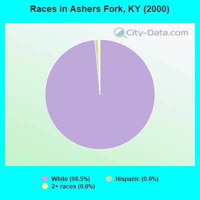
- 1,60298.5%White alone
- 140.9%Hispanic
- 100.6%Two or more races
- 10.06%Black alone
Races in Ashers Fork detailed stats: ancestries, foreign born residents, place of birth
 Recent articles from our blog. Our writers, many of them Ph.D. graduates or candidates, create easy-to-read articles on a wide variety of topics.
Current Local Time: EST time zone
Elevation: 1400 feet
Land area: 84.2 square miles.
Population density: 19 people per square mile (very low).

| Ashers Fork CCD: | 1.1% ($199) |
| Kentucky: | 0.8% ($610) |
Nearest city with pop. 50,000+: Knoxville, TN  (75.7 miles , pop. 173,890).
Nearest city with pop. 200,000+: Fayette, KY (84.3 miles , pop. 260,512).
Nearest city with pop. 1,000,000+: Chicago, IL (397.2 miles , pop. 2,896,016).
Nearest cities:
), ), ), ), )Latitude: 37.03 N, Longitude: 83.61 W
Area code commonly used in this area: 606

| Here: | 6.1% |
| Kentucky: | 3.8% |
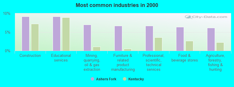
- Construction (9.2%)
- Educational services (9.2%)
- Mining, quarrying, oil & gas extraction (6.9%)
- Furniture & related product manufacturing (6.7%)
- Professional, scientific, technical services (6.7%)
- Food & beverage stores (6.4%)
- Agriculture, forestry, fishing & hunting (6.1%)
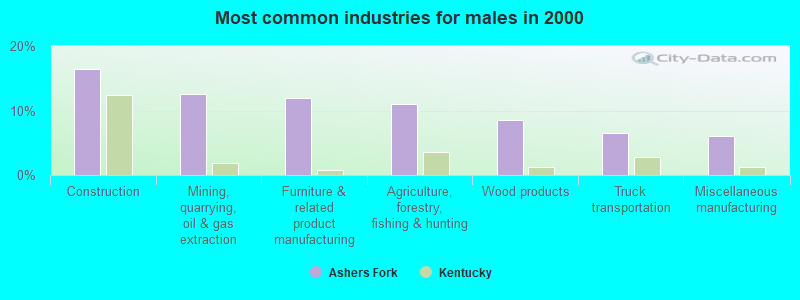
- Construction (16.5%)
- Mining, quarrying, oil & gas extraction (12.5%)
- Furniture & related product manufacturing (12.0%)
- Agriculture, forestry, fishing & hunting (11.0%)
- Wood products (8.5%)
- Truck transportation (6.5%)
- Miscellaneous manufacturing (6.0%)
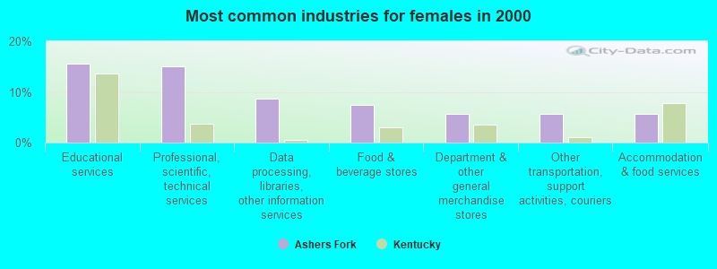
- Educational services (15.6%)
- Professional, scientific, technical services (15.0%)
- Data processing, libraries, other information services (8.8%)
- Food & beverage stores (7.5%)
- Department & other general merchandise stores (5.6%)
- Other transportation, support activities, couriers (5.6%)
- Accommodation & food services (5.6%)
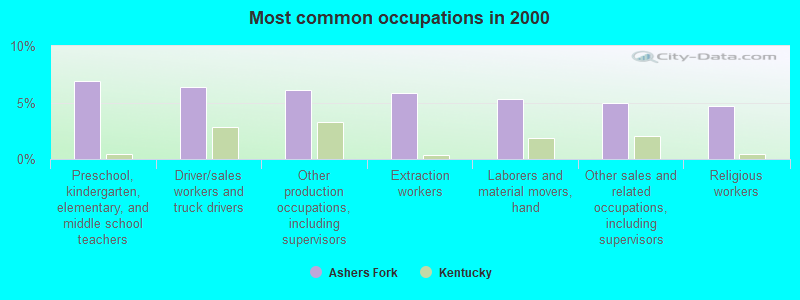
- Preschool, kindergarten, elementary, and middle school teachers (6.9%)
- Driver/sales workers and truck drivers (6.4%)
- Other production occupations, including supervisors (6.1%)
- Extraction workers (5.8%)
- Laborers and material movers, hand (5.3%)
- Other sales and related occupations, including supervisors (5.0%)
- Religious workers (4.7%)
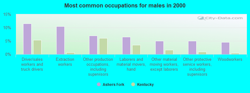
- Driver/sales workers and truck drivers (11.5%)
- Extraction workers (10.5%)
- Other production occupations, including supervisors (7.0%)
- Laborers and material movers, hand (6.5%)
- Other material moving workers, except laborers (5.0%)
- Other protective service workers, including supervisors (5.0%)
- Woodworkers (4.5%)
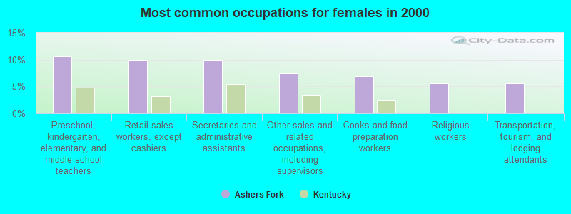
- Preschool, kindergarten, elementary, and middle school teachers (10.6%)
- Retail sales workers, except cashiers (10.0%)
- Secretaries and administrative assistants (10.0%)
- Other sales and related occupations, including supervisors (7.5%)
- Cooks and food preparation workers (6.9%)
- Religious workers (5.6%)
- Transportation, tourism, and lodging attendants (5.6%)
Average climate in Ashers Fork, Kentucky
Based on data reported by over 4,000 weather stations


Tornado activity:
Ashers Fork-area historical tornado activity is significantly below Kentucky state average. It is 43% smaller than the overall U.S. average.
On 6/29/1973, a category F3 (max. wind speeds 158-206 mph) tornado 26.9 miles away from the Ashers Fork place center injured 2 people and caused between $50,000 and $500,000 in damages.
On 5/9/1988, a category F3 tornado 30.1 miles away from the place center killed one person and injured 15 people and caused between $5,000,000 and $50,000,000 in damages.
Earthquake activity:
Ashers Fork-area historical earthquake activity is significantly above Kentucky state average. It is 58% greater than the overall U.S. average.On 7/27/1980 at 18:52:21, a magnitude 5.2 (5.1 MB, 4.7 MS, 5.0 UK, 5.2 UK, Class: Moderate, Intensity: VI - VII) earthquake occurred 83.1 miles away from the city center
On 8/9/2020 at 12:07:37, a magnitude 5.1 (5.1 MW, Depth: 4.7 mi) earthquake occurred 144.6 miles away from Ashers Fork center
On 11/30/1973 at 07:48:41, a magnitude 4.7 (4.7 MB, 4.6 ML, Class: Light, Intensity: IV - V) earthquake occurred 87.6 miles away from the city center
On 9/7/1988 at 02:28:09, a magnitude 4.6 (4.5 MB, 4.6 LG) earthquake occurred 78.2 miles away from the city center
On 8/23/2011 at 17:51:04, a magnitude 5.8 (5.8 MW, Depth: 3.7 mi) earthquake occurred 317.2 miles away from Ashers Fork center
On 4/18/2008 at 09:36:59, a magnitude 5.4 (5.1 MB, 4.8 MS, 5.4 MW, 5.2 MW) earthquake occurred 253.7 miles away from the city center
Magnitude types: regional Lg-wave magnitude (LG), body-wave magnitude (MB), local magnitude (ML), surface-wave magnitude (MS), moment magnitude (MW)
Natural disasters:
The number of natural disasters in Clay County (31) is a lot greater than the US average (15).Major Disasters (Presidential) Declared: 23
Emergencies Declared: 3
Causes of natural disasters: Floods: 21, Storms: 18, Mudslides: 9, Tornadoes: 9, Winter Storms: 6, Landslides: 5, Winds: 3, Fires: 2, Snows: 2, Blizzard: 1, Freeze: 1, Hurricane: 1, Snowfall: 1, Snowstorm: 1, Other: 1 (Note: some incidents may be assigned to more than one category).
Hospitals and medical centers near Ashers Fork:
- CUMBERLAND VAL DIST HLTH DEPT (Hospital, about 12 miles away; MANCHESTER, KY)
- MEMORIAL HOSPITAL HOME HEALTH CARE (Home Health Center, about 13 miles away; MANCHESTER, KY)
- MARY BRECKINRIDGE HOME HEALTH AGENCY (Home Health Center, about 16 miles away; HYDEN, KY)
- MARY BRECKINRIDGE ARH HOSPITAL Critical Access Hospitals (about 16 miles away; HYDEN, KY)
Colleges/universities with over 2000 students nearest to Ashers Fork:
- Hazard Community and Technical College (about 28 miles; Hazard, KY; Full-time enrollment: 2,087)
- Lincoln Memorial University (about 32 miles; Harrogate, TN; FT enrollment: 3,706)
- Southeast Kentucky Community and Technical College (about 35 miles; Cumberland, KY; FT enrollment: 2,196)
- University of the Cumberlands (about 37 miles; Williamsburg, KY; FT enrollment: 3,585)
- Somerset Community College (about 56 miles; Somerset, KY; FT enrollment: 4,698)
- Walters State Community College (about 60 miles; Morristown, TN; FT enrollment: 4,359)
- Eastern Kentucky University (about 62 miles; Richmond, KY; FT enrollment: 13,525)
Points of interest:
Notable locations in Ashers Fork: Sandy Fork Coal Preparation Plant (A), Bright Shade Fire Department (B), Red Bird Volunteer Fire and Rescue (C). Display/hide their locations on the map
Churches in Ashers Fork include: Mill Creek Church (A), Missionary Church (B), Flat Creek Church (C), Phillips Fork Church (D), Bear Creek Church (E), Mud Lick Church (F), Hubbards Fork Church (G), Flat Creek Mission Church (H). Display/hide their locations on the map
Streams, rivers, and creeks: Carpenter Branch (A), Cave Branch (B), Darbs Branch (C), Drum Branch (D), Flat Creek (E), Grubb Branch (F), Holly Bottom Branch (G), Hubbards Fork (H), Hurricane Branch (I). Display/hide their locations on the map
| This place: | 2.6 people |
| Kentucky: | 2.5 people |
| This place: | 74.7% |
| Whole state: | 66.9% |
| This place: | 4.7% |
| Whole state: | 6.4% |
Likely homosexual households (counted as self-reported same-sex unmarried-partner households)
- Lesbian couples: 0.6% of all households
- Gay men: 0.2% of all households
| This place: | 42.5% |
| Whole state: | 15.8% |
| This place: | 17.1% |
| Whole state: | 6.6% |
4 people in other nonhousehold living situations in 2000
For population 15 years and over in Ashers Fork:
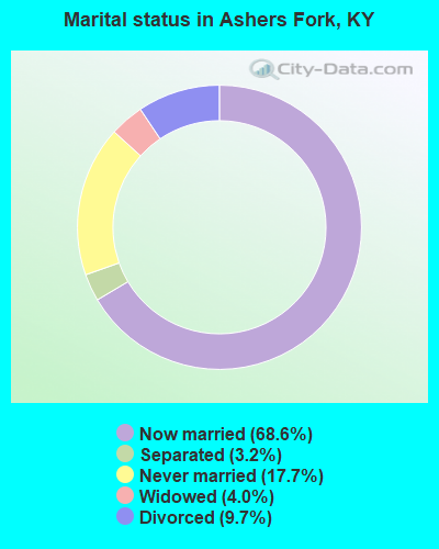
- Never married: 17.7%
- Now married: 68.6%
- Separated: 3.2%
- Widowed: 4.0%
- Divorced: 9.7%
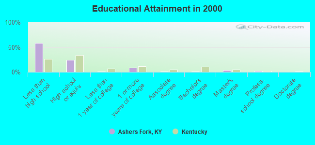
For population 25 years and over in Ashers Fork:
- High school or higher: 41.5%
- Bachelor's degree or higher: 6.5%
- Graduate or professional degree: 5.6%
- Unemployed: 13.0%
- Mean travel time to work (commute): 35.9 minutes
| Here: | 22.1 |
| Kentucky average: | 13.8 |
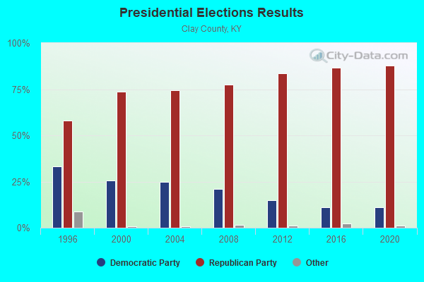
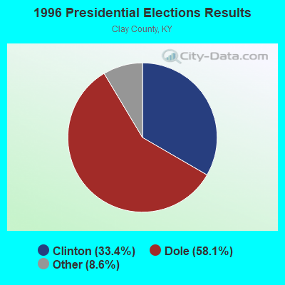
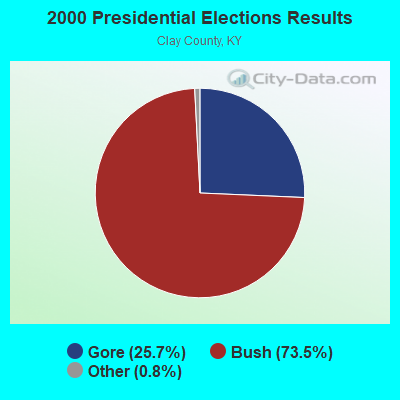

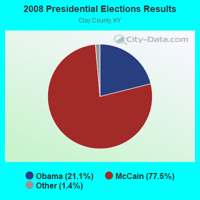
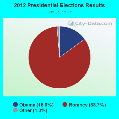
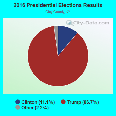
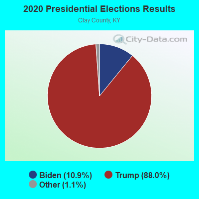
Graphs represent county-level data. Detailed 2008 Election Results
Religion statistics for Ashers Fork, KY (based on Clay County data)
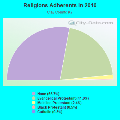
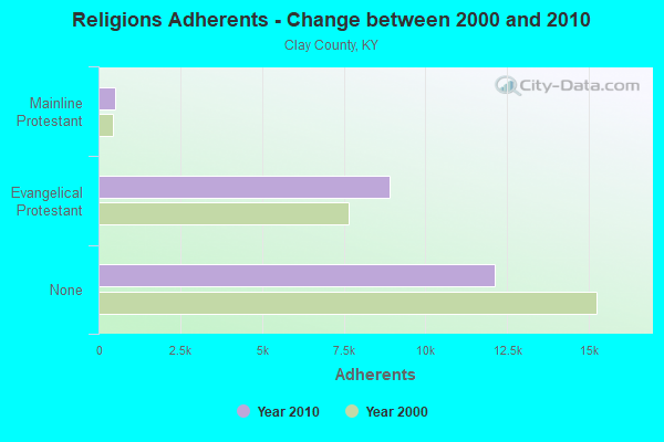
| Religion | Adherents | Congregations |
|---|---|---|
| Evangelical Protestant | 8,920 | 39 |
| Mainline Protestant | 516 | 8 |
| Black Protestant | 119 | 1 |
| Catholic | 69 | 1 |
| Other | - | 1 |
| None | 12,106 | - |
Food Environment Statistics:
| Clay County: | 1.68 / 10,000 pop. |
| Kentucky: | 2.19 / 10,000 pop. |
| Clay County: | 0.84 / 10,000 pop. |
| Kentucky: | 0.74 / 10,000 pop. |
| Clay County: | 5.89 / 10,000 pop. |
| State: | 4.36 / 10,000 pop. |
| Here: | 1.26 / 10,000 pop. |
| State: | 5.74 / 10,000 pop. |
| This county: | 11.4% |
| Kentucky: | 11.0% |
| Clay County: | 31.0% |
| Kentucky: | 30.0% |
| This county: | 22.1% |
| State: | 15.9% |
Strongest AM radio stations in Ashers Fork:
- WKLB (1290 AM; 5 kW; MANCHESTER, KY; Owner: BARKER BROADCASTING COMPANY, INC.)
- WFSR (970 AM; 5 kW; HARLAN, KY; Owner: EASTERN BROADCASTING COMPAY)
- WHLN (1410 AM; 5 kW; HARLAN, KY)
- WKVL (850 AM; daytime; 50 kW; KNOXVILLE, TN; Owner: HORNE RADIO, LLC)
- WKIC (1390 AM; 5 kW; HAZARD, KY)
- WKDP (1330 AM; 5 kW; CORBIN, KY; Owner: EUBANKS BROADCASTING, INC.)
- WWXL (1450 AM; 1 kW; MANCHESTER, KY; Owner: THE PROMISE PARTNERSHIP)
- WMIK (560 AM; 2 kW; MIDDLESBORO, KY; Owner: GATEWAY BROADCASTING, INC.)
- WEKC (710 AM; daytime; 4 kW; WILLIAMSBURG, KY; Owner: GERALD PARKS)
- WMTC (730 AM; 5 kW; VANCLEVE, KY; Owner: THE KENTUCKY MOUNTAIN HOLINESS ASSN.)
- WEKG (810 AM; daytime; 5 kW; JACKSON, KY; Owner: INTERMOUNTAIN B/CING CO., INC.)
- WHAS (840 AM; 50 kW; LOUISVILLE, KY; Owner: CLEAR CHANNEL BROADCASTING LICENSES, INC.)
- WFGW (1010 AM; 50 kW; BLACK MOUNTAIN, NC; Owner: BLUE RIDGE BROADCASTING CORP.)
Strongest FM radio stations in Ashers Fork:
- WTUK (105.1 FM; HARLAN, KY; Owner: EASTERN BROADCASTING COMPANY)
- WWLT (103.1 FM; MANCHESTER, KY; Owner: VERNON R. BALDWIN, INC.)
- WSGS (101.1 FM; HAZARD, KY; Owner: MOUNTAIN BROADCASTING SERVICE, INC.)
- WSEH (102.7 FM; CUMBERLAND, KY; Owner: CUMBERLAND CITY BROADCASTING, INC.)
- WRIL (106.3 FM; PINEVILLE, KY; Owner: PINE HILLS BROADCASTING, INC.)
- WTBK (105.7 FM; MANCHESTER, KY; Owner: MANCHESTER COMMUNICATIONS, INC.)
- WMIK-FM (92.7 FM; MIDDLESBORO, KY; Owner: GATEWAY BROADCASTING, INC.)
- WZQQ (97.9 FM; HYDEN, KY; Owner: LESLIE COUNTY BROADCASTING, INC.)
- WEKH (90.9 FM; HAZARD, KY; Owner: EASTERN KENTUCKY UNIVERSITY)
- WJMD (104.7 FM; HAZARD, KY; Owner: HAZARD BROADCASTING SERVICES)
- WAXM (93.5 FM; BIG STONE GAP, VA; Owner: VALLEY BROADCASTING, INC.)
- WKDP-FM (99.5 FM; CORBIN, KY; Owner: EUBANKS BROADCASTING, INC.)
- WIFX-FM (94.3 FM; JENKINS, KY; Owner: LETCHER COUNTY BROADCASTING, INC)
- WXKQ-FM (103.9 FM; WHITESBURG, KY; Owner: T.C.W. BROADCASTING , INC.)
- WMMT (88.7 FM; WHITESBURG, KY; Owner: APPALSHOP, INCORPORATED)
- WTFM (98.5 FM; KINGSPORT, TN; Owner: HOLSTON VALLEY BROADCASTING CORP.)
- W223AA (92.5 FM; BIG STONE GAP, VA; Owner: VALLEY BROADCASTING, INC.)
- WCTU (105.9 FM; TAZEWELL, TN; Owner: STAIR COMPANY, INC)
- WYGE (92.3 FM; LONDON, KY; Owner: ETHEL HUFF BROADCASTING, LLC)
- WJDT (106.5 FM; ROGERSVILLE, TN; Owner: C & S BROADCASTING)
TV broadcast stations around Ashers Fork:
- WYMT-TV (Channel 57; HAZARD, KY; Owner: WYMT LICENSEE CORP.)
- W26BK (Channel 26; TALBERT, KY; Owner: MS COMMUNICATIONS, LLC)
- W24BT (Channel 24; TALBERT, KY; Owner: MS COMMUNICATIONS, LLC)
- W16BI (Channel 16; TALBERT, KY; Owner: MS COMMUNICATIONS, LLC)
- WAGV (Channel 44; HARLAN, KY; Owner: LIVING FAITH MINISTRIES, INC.)
- WKHA (Channel 35; HAZARD, KY; Owner: KENTUCKY AUTHORITY FOR EDUCATIONAL TV)
- WLJC-TV (Channel 65; BEATTYVILLE, KY; Owner: HOUR OF HARVEST, INC.)
- W31BU (Channel 31; TALBERT, KY; Owner: MS COMMUNICATIONS, LLC)
- W53BQ (Channel 53; TALBERT, KY; Owner: MS COMMUNICATIONS, LLC)
- W69ED (Channel 69; TALBERT, KY; Owner: MS COMMUNICATIONS, LLC)
FCC Registered Broadcast Land Mobile Towers:
1- Lookout Tower Rd & Ky 1524 2 Mi S (Lat: 36.995083 Lon: -83.594917), Call Sign: KDV603,
Assigned Frequencies: 453.300 MHz, 453.300 MHz, 453.600 MHz, 453.600 MHz, 453.900 MHz, 453.900 MHz, Grant Date: 11/04/2021, Expiration Date: 12/05/2031, Registrant: Kentucky State Police, 1301 Louisville Rd, Frankfort, KY 40601, Phone: (502) 782-2067, Fax: (502) 227-8788, Email:
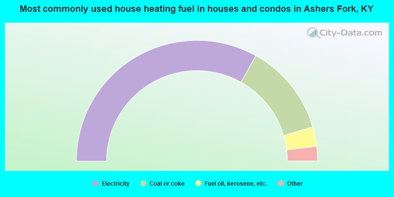
- 66.3%Electricity
- 24.7%Coal or coke
- 5.2%Fuel oil, kerosene, etc.
- 2.6%Wood
- 1.3%Bottled, tank, or LP gas
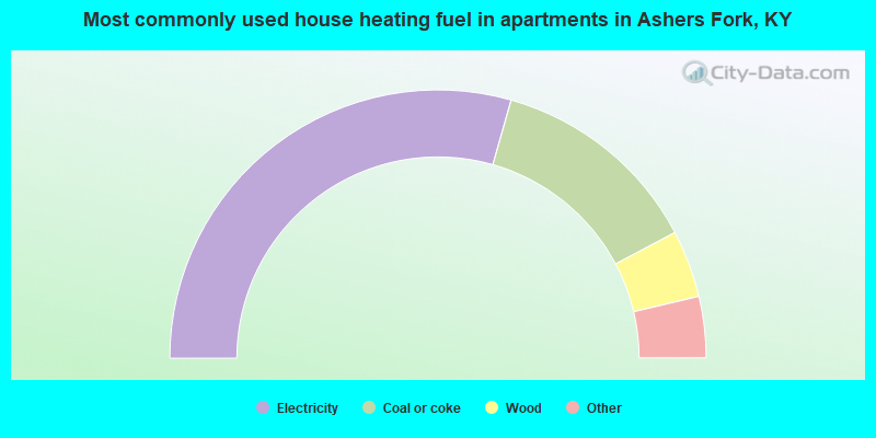
- 58.8%Electricity
- 25.7%Coal or coke
- 8.1%Wood
- 3.7%Bottled, tank, or LP gas
- 3.7%Fuel oil, kerosene, etc.
Ashers Fork compared to Kentucky state average:
- Median household income below state average.
- Median house value significantly below state average.
- Black race population percentage significantly below state average.
- Hispanic race population percentage significantly below state average.
- Median age below state average.
- Foreign-born population percentage significantly below state average.
- Length of stay since moving in significantly above state average.
- Number of rooms per house significantly below state average.
- House age significantly below state average.
- Number of college students significantly below state average.
- Percentage of population with a bachelor's degree or higher significantly below state average.