Benton, New Hampshire
Submit your own pictures of this town and show them to the world
- OSM Map
- General Map
- Google Map
- MSN Map
Population change since 2000: +15.9%
 |
| Males: 184 | |
| Females: 180 |
| Median resident age: | 52.8 years |
| New Hampshire median age: | 43.9 years |
Zip codes: 03785.
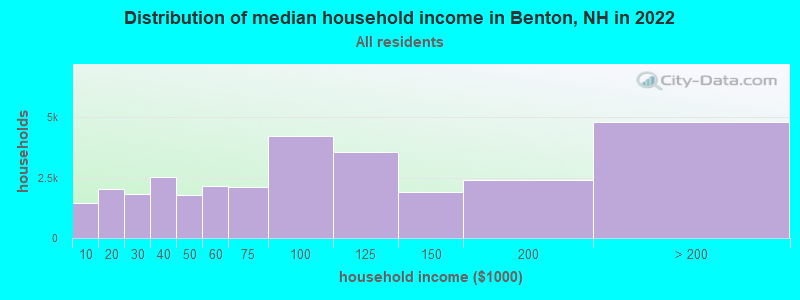
| Benton: | $66,804 |
| NH: | $89,992 |
Estimated per capita income in 2022: $30,062 (it was $13,220 in 2000)
Benton town income, earnings, and wages data
Estimated median house or condo value in 2022: $245,790 (it was $76,900 in 2000)
| Benton: | $245,790 |
| NH: | $384,700 |
Mean prices in 2022: all housing units: $486,096; detached houses: $533,852; townhouses or other attached units: $375,744; in 2-unit structures: $230,260; in 3-to-4-unit structures: $242,363; in 5-or-more-unit structures: $588,257; mobile homes: $127,035
Detailed information about poverty and poor residents in Benton, NH


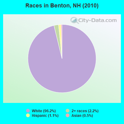
- 35096.2%White alone
- 82.2%Two or more races
- 41.1%Hispanic
- 20.5%Asian alone
Races in Benton detailed stats: ancestries, foreign born residents, place of birth
 Recent articles from our blog. Our writers, many of them Ph.D. graduates or candidates, create easy-to-read articles on a wide variety of topics.

 | Picture Thread for NH (1997 replies) |
| Hillary won New Hampshire ? (34 replies) |
| Vacation Home in White Mountains/Benton, NH? (9 replies) |
| Auto mechanic-Lincoln/Woodstock/Plymouth (6 replies) |
| Best town in NH for a chest-thumping Libertarian? (30 replies) |
| What town in New Hampshire most closely represents or reminds you of small town America? (857 replies) |
Latest news from Benton, NH collected exclusively by city-data.com from local newspapers, TV, and radio stations
Ancestries: English (25.2%), French (22.9%), Irish (20.4%), German (9.2%), United States (7.6%), Scottish (7.0%).
Current Local Time: EST time zone
Incorporated in 1764
Elevation: 1272 feet
Land area: 48.1 square miles.
Population density: 7.6 people per square mile (very low).
5 residents are foreign born
| This town: | 1.6% |
| New Hampshire: | 4.4% |
| Benton town: | 0.7% ($535) |
| New Hampshire: | 2.3% ($2,946) |
Nearest city with pop. 50,000+: Manchester, NH  (75.8 miles , pop. 107,006).
Nearest city with pop. 200,000+: Boston, MA (125.2 miles , pop. 589,141).
Nearest city with pop. 1,000,000+: Bronx, NY (241.5 miles , pop. 1,332,650).
Nearest cities:
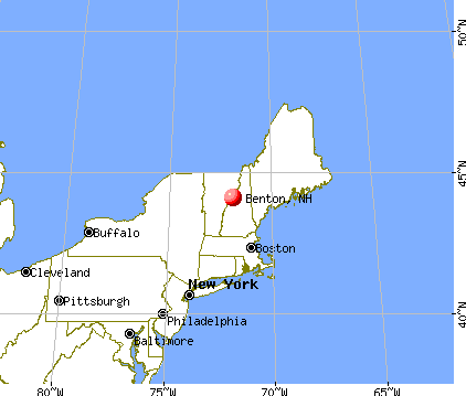
), ), Latitude: 44.03 N, Longitude: 71.92 W
Area code commonly used in this area: 603

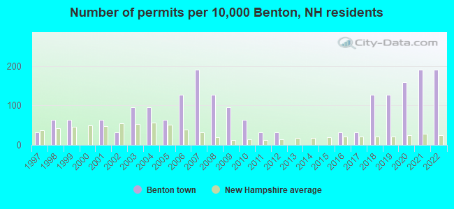
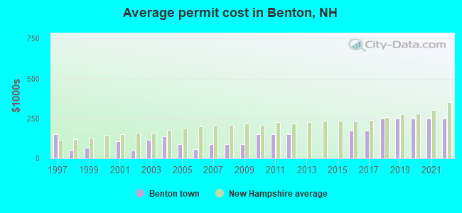
Single-family new house construction building permits:
- 2022: 6 buildings, average cost: $249,800
- 2021: 6 buildings, average cost: $249,800
- 2020: 5 buildings, average cost: $249,800
- 2019: 4 buildings, average cost: $249,800
- 2018: 4 buildings, average cost: $249,800
- 2017: 1 building, cost: $175,000
- 2016: 1 building, cost: $175,000
- 2012: 1 building, cost: $150,000
- 2011: 1 building, cost: $150,000
- 2010: 2 buildings, average cost: $150,000
- 2009: 3 buildings, average cost: $88,300
- 2008: 4 buildings, average cost: $88,300
- 2007: 6 buildings, average cost: $88,300
- 2006: 4 buildings, average cost: $56,300
- 2005: 2 buildings, average cost: $90,000
- 2004: 3 buildings, average cost: $140,000
- 2003: 3 buildings, average cost: $116,700
- 2002: 1 building, cost: $50,000
- 2001: 2 buildings, average cost: $105,000
- 1999: 2 buildings, average cost: $65,000
- 1998: 2 buildings, average cost: $50,000
- 1997: 1 building, cost: $150,000
| Here: | 2.8% |
| New Hampshire: | 2.5% |
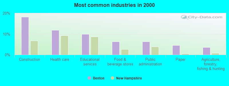
- Construction (18.2%)
- Health care (11.8%)
- Educational services (10.0%)
- Food & beverage stores (6.4%)
- Public administration (6.4%)
- Paper (4.5%)
- Agriculture, forestry, fishing & hunting (3.6%)
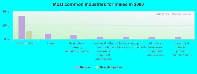
- Construction (33.9%)
- Paper (8.5%)
- Agriculture, forestry, fishing & hunting (6.8%)
- Lumber & other construction materials merchant wholesalers (3.4%)
- Electrical equipment, appliances, components (3.4%)
- Alcoholic beverages merchant wholesalers (3.4%)
- Furniture & related product manufacturing (3.4%)
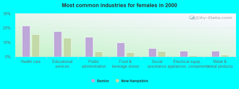
- Health care (21.6%)
- Educational services (17.6%)
- Public administration (13.7%)
- Food & beverage stores (9.8%)
- Social assistance (5.9%)
- Electrical equipment, appliances, components (3.9%)
- Metal & metal products (3.9%)
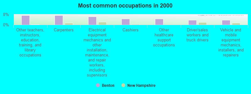
- Other teachers, instructors, education, training, and library occupations (7.3%)
- Carpenters (7.3%)
- Electrical equipment mechanics and other installation, maintenance, and repair workers, including supervisors (6.4%)
- Cashiers (4.5%)
- Other healthcare support occupations (4.5%)
- Driver/sales workers and truck drivers (3.6%)
- Vehicle and mobile equipment mechanics, installers, and repairers (3.6%)
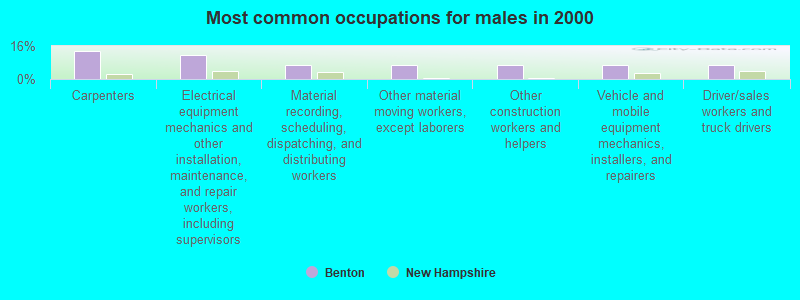
- Carpenters (13.6%)
- Electrical equipment mechanics and other installation, maintenance, and repair workers, including supervisors (11.9%)
- Material recording, scheduling, dispatching, and distributing workers (6.8%)
- Other material moving workers, except laborers (6.8%)
- Other construction workers and helpers (6.8%)
- Vehicle and mobile equipment mechanics, installers, and repairers (6.8%)
- Driver/sales workers and truck drivers (6.8%)
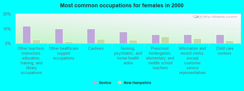
- Other teachers, instructors, education, training, and library occupations (11.8%)
- Other healthcare support occupations (9.8%)
- Cashiers (9.8%)
- Nursing, psychiatric, and home health aides (7.8%)
- Preschool, kindergarten, elementary, and middle school teachers (5.9%)
- Information and record clerks, except customer service representatives (5.9%)
- Child care workers (5.9%)
Average climate in Benton, New Hampshire
Based on data reported by over 4,000 weather stations


(lower is better)
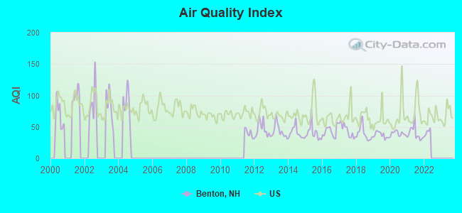
Air Quality Index (AQI) level in 2021 was 39.8. This is significantly better than average.
| City: | 39.8 |
| U.S.: | 72.6 |
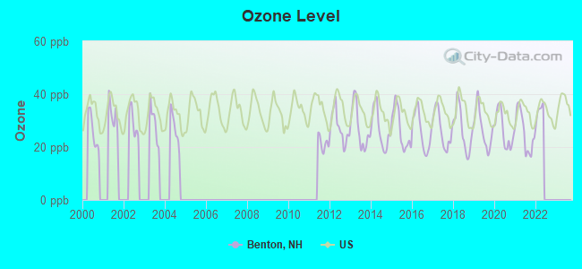
Ozone [ppb] level in 2021 was 25.7. This is better than average. Closest monitor was 5.9 miles away from the city center.
| City: | 25.7 |
| U.S.: | 33.3 |
Tornado activity:
Benton-area historical tornado activity is significantly below New Hampshire state average. It is 78% smaller than the overall U.S. average.
On 8/11/1966, a category F2 (max. wind speeds 113-157 mph) tornado 2.9 miles away from the Benton town center caused between $50,000 and $500,000 in damages.
On 5/11/1973, a category F2 tornado 31.7 miles away from the town center .
Earthquake activity:
Benton-area historical earthquake activity is significantly above New Hampshire state average. It is 72% smaller than the overall U.S. average.On 4/20/2002 at 10:50:47, a magnitude 5.3 (5.3 ML, Depth: 3.0 mi, Class: Moderate, Intensity: VI - VII) earthquake occurred 94.2 miles away from the city center
On 4/20/2002 at 10:50:47, a magnitude 5.2 (5.2 MB, 4.2 MS, 5.2 MW, 5.0 MW) earthquake occurred 94.5 miles away from Benton center
On 10/7/1983 at 10:18:46, a magnitude 5.3 (5.1 MB, 5.3 LG, 5.1 ML) earthquake occurred 120.6 miles away from the city center
On 1/19/1982 at 00:14:42, a magnitude 4.7 (4.5 MB, 4.7 MD, 4.5 LG, Class: Light, Intensity: IV - V) earthquake occurred 39.9 miles away from the city center
On 10/16/2012 at 23:12:25, a magnitude 4.7 (4.7 ML, Depth: 10.0 mi) earthquake occurred 69.8 miles away from Benton center
On 6/16/1995 at 12:13:11, a magnitude 3.8 (3.8 LG, Depth: 3.1 mi, Class: Light, Intensity: II - III) earthquake occurred 17.9 miles away from the city center
Magnitude types: regional Lg-wave magnitude (LG), body-wave magnitude (MB), duration magnitude (MD), local magnitude (ML), surface-wave magnitude (MS), moment magnitude (MW)
Natural disasters:
The number of natural disasters in Grafton County (32) is a lot greater than the US average (15).Major Disasters (Presidential) Declared: 20
Emergencies Declared: 9
Causes of natural disasters: Floods: 16, Storms: 16, Hurricanes: 3, Snows: 3, Winter Storms: 3, Tropical Storms: 2, Blizzard: 1, Heavy Rain: 1, Ice Storm: 1, Landslide: 1, Snowfall: 1, Snowstorm: 1, Wind: 1, Other: 1 (Note: some incidents may be assigned to more than one category).
Colleges/universities with over 2000 students nearest to Benton:
- Plymouth State University (about 22 miles; Plymouth, NH; Full-time enrollment: 4,838)
- Dartmouth College (about 30 miles; Hanover, NH; FT enrollment: 6,030)
- Norwich University (about 38 miles; Northfield, VT; FT enrollment: 4,221)
- NHTI-Concord's Community College (about 59 miles; Concord, NH; FT enrollment: 2,865)
- Middlebury College (about 63 miles; Middlebury, VT; FT enrollment: 3,077)
- Castleton State College (about 70 miles; Castleton, VT; FT enrollment: 2,079)
- Saint Michael's College (about 70 miles; Colchester, VT; FT enrollment: 2,336)
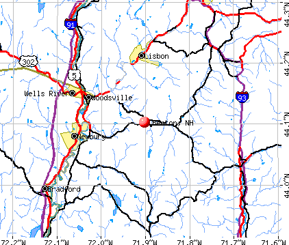
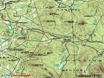
Points of interest:
Notable locations in Benton: Long Pond Picnic Ground (A), Long Pond Picnic Area (B). Display/hide their locations on the map
Cemeteries: Benton Cemetery (1), East Cemetery (2). Display/hide their locations on the map
Lakes and reservoirs: Mud Pond (A), Long Pond (B), Oliverian Pond (C). Display/hide their locations on the map
Streams, rivers, and creeks: Howe Hill (A), Blueberry Mountain Brook (B), Little Tunnel Brook (C), Slide Brook (D), Spillman Brook (E), Still Brook (F), Jeffers Brook (G). Display/hide their locations on the map
| This town: | 2.4 people |
| New Hampshire: | 2.5 people |
| This town: | 69.8% |
| Whole state: | 66.3% |
| This town: | 4.7% |
| Whole state: | 8.3% |
No gay or lesbian households reported
| This town: | 8.8% |
| Whole state: | 6.5% |
| This town: | 6.0% |
| Whole state: | 2.8% |
89 people in nursing homes in 2000
4 people in other nonhousehold living situations in 2000
For population 15 years and over in Benton:
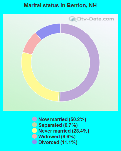
- Never married: 28.4%
- Now married: 50.2%
- Separated: 0.7%
- Widowed: 9.6%
- Divorced: 11.1%
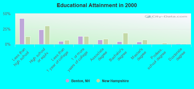
For population 25 years and over in Benton:
- High school or higher: 57.7%
- Bachelor's degree or higher: 8.8%
- Graduate or professional degree: 4.6%
- Unemployed: 1.8%
- Mean travel time to work (commute): 27.1 minutes
| Here: | 16.3 |
| New Hampshire average: | 10.9 |


Graphs represent county-level data. Detailed 2008 Election Results
Religion statistics for Benton, NH (based on Grafton County data)


| Religion | Adherents | Congregations |
|---|---|---|
| Catholic | 9,503 | 12 |
| Mainline Protestant | 7,832 | 57 |
| Evangelical Protestant | 1,494 | 29 |
| Other | 1,320 | 11 |
| None | 68,969 | - |
Food Environment Statistics:
| Grafton County: | 3.87 / 10,000 pop. |
| New Hampshire: | 2.14 / 10,000 pop. |
| This county: | 0.23 / 10,000 pop. |
| State: | 0.15 / 10,000 pop. |
| Grafton County: | 1.29 / 10,000 pop. |
| New Hampshire: | 1.78 / 10,000 pop. |
| Grafton County: | 6.45 / 10,000 pop. |
| State: | 4.02 / 10,000 pop. |
| Here: | 14.41 / 10,000 pop. |
| State: | 9.70 / 10,000 pop. |
| This county: | 7.2% |
| New Hampshire: | 7.6% |
| Grafton County: | 22.9% |
| New Hampshire: | 24.4% |
| This county: | 15.9% |
| State: | 15.9% |
Strongest AM radio stations in Benton:
- WTWN (1100 AM; daytime; 5 kW; WELLS RIVER, VT; Owner: PUFFER BROADCASTING, INC.)
- WPNH (1300 AM; 5 kW; PLYMOUTH, NH; Owner: NORTHEAST COMMUNICATIONS CORPORATION)
- WRKO (680 AM; 50 kW; BOSTON, MA; Owner: ENTERCOM BOSTON LICENSE, LLC)
- WCHP (760 AM; 35 kW; CHAMPLAIN, NY; Owner: CHAMPLAIN RADIO, INC.)
- WNTK (1020 AM; 10 kW; NEWPORT, NH; Owner: KOOR COMMUNICATIONS, INC.)
- WNNZ (640 AM; 50 kW; WESTFIELD, MA; Owner: CLEAR CHANNEL BROADCASTING LICENSES, INC.)
- WCRN (830 AM; 50 kW; WORCESTER, MA; Owner: CARTER BROADCASTING CORPORATION)
- WDEV (550 AM; 5 kW; WATERBURY, VT; Owner: RADIO VERMONT, INC.)
- WEEI (850 AM; 50 kW; BOSTON, MA; Owner: ENTERCOM BOSTON LICENSE, LLC)
- WGY (810 AM; 50 kW; SCHENECTADY, NY; Owner: CLEAR CHANNEL BROADCASTING LICENSES, INC.)
- WKOX (1200 AM; 50 kW; FRAMINGHAM, MA; Owner: CAPSTAR TX LIMITED PARTNERSHIP)
- WBZ (1030 AM; 50 kW; BOSTON, MA; Owner: INFINITY BROADCASTING OPERATIONS, INC.)
- WBIX (1060 AM; 40 kW; NATICK, MA; Owner: LANGER BROADCASTING CORPORATION)
Strongest FM radio stations in Benton:
- WVFM (105.7 FM; CAMPTON, NH; Owner: DEVON BROADCASTING COMPANY, INC.)
- WPKQ (103.7 FM; NORTH CONWAY, NH; Owner: CITADEL BROADCASTING COMPANY)
- WHOM (94.9 FM; MT. WASHINGTON, NH; Owner: CITADEL BROADCASTING COMPANY)
- WYKR-FM (101.3 FM; HAVERHILL, NH; Owner: PUFFER BROADCASTING, INC.)
- WPNH-FM (100.1 FM; PLYMOUTH, NH; Owner: NORTHEAST COMMUNICATIONS CORPORATION)
- WLTN-FM (96.7 FM; LISBON, NH; Owner: PROFILE BROADCASTING CO., INC.)
- WSCY (106.9 FM; MOULTONBOROUGH, NH; Owner: NORTHEAST COMMUNICATIONS CORPORATION)
- WMTK (106.3 FM; LITTLETON, NH; Owner: VERMONT BROADCAST ASSOCIATES, INC.)
- WGMT (97.7 FM; LYNDON, VT; Owner: VERMONT BROADCAST ASSOCIATES, INC.)
- WEVH (91.3 FM; HANOVER, NH; Owner: NEW HAMPSHIRE PUBLIC RADIO INC)
- WDOT (95.7 FM; DANVILLE, VT; Owner: MONTPELIER BROADCASTING INC)
- WCVT (101.7 FM; STOWE, VT; Owner: RADIO VERMONT CLASSICS, L.L.C.)
- WHDQ (106.1 FM; CLAREMONT, NH; Owner: GREAT NORTHERN RADIO, L.L.C.)
- WEBK (105.3 FM; KILLINGTON, VT; Owner: 6 JOHNSON ROAD LICENSES, INC.)
- WJJR (98.1 FM; RUTLAND, VT; Owner: 6 JOHNSON ROAD LICENSES, INC.)
- WZRT (97.1 FM; RUTLAND, VT; Owner: CAPSTAR TX LIMITED PARTNERSHIP)
- WLKC (103.3 FM; WATERBURY, VT; Owner: RADIO BROADCASTING SERVICES, INC.)
- WVPS (107.9 FM; BURLINGTON, VT; Owner: VERMONT PUBLIC RADIO)
- WEZF (92.9 FM; BURLINGTON, VT; Owner: CAPSTAR TX LIMITED PARTNERSHIP)
- WDEV-FM (96.1 FM; WARREN, VT; Owner: RADIO VERMONT, INC.)
TV broadcast stations around Benton:
- WLED-TV (Channel 49; LITTLETON, NH; Owner: UNIVERSITY OF NEW HAMPSHIRE)
- W15BK (Channel 15; HANOVER, NH; Owner: UNIVERSITY OF NEW HAMPSHIRE)
Benton fatal accident list:
Sep 3, 2000 02:45 PM, Long Pond Road, Vehicles: 1, Persons: 3, Fatalities: 1
- National Bridge Inventory (NBI) Statistics
- 3Number of bridges
- 16ft / 4.8mTotal length
- $9,426,000Total costs
- 2,327Total average daily traffic
- 101Total average daily truck traffic
- 3,442Total future (year 2042) average daily traffic
FCC Registered Amateur Radio Licenses:
1- Call Sign: N1YBX, Licensee ID: L00682744, Grant Date: 10/31/2016, Expiration Date: 11/04/2026, Certifier: Francesco M Pesce Jr, Registrant: Francesco M Pesce Jr, 527 Coventry Rd, Benton, NH 03785
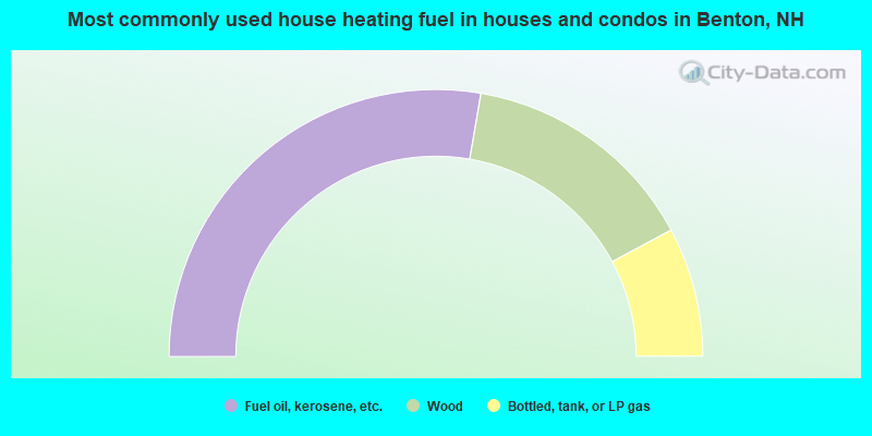
- 55.4%Fuel oil, kerosene, etc.
- 28.9%Wood
- 15.7%Bottled, tank, or LP gas
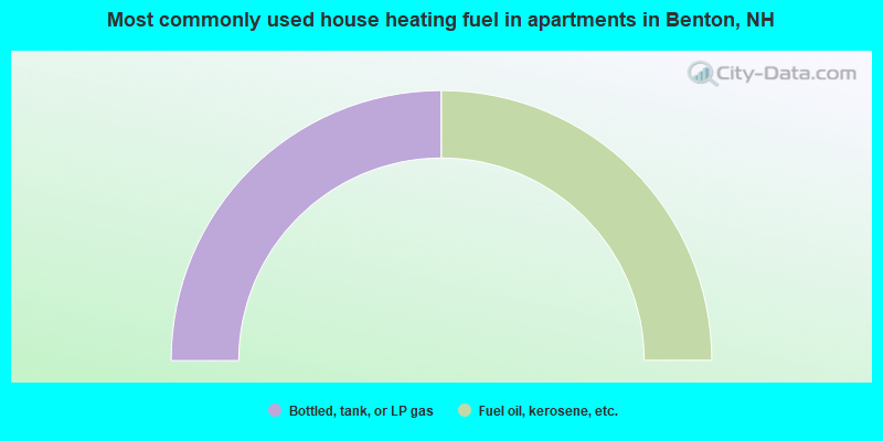
- 50.0%Bottled, tank, or LP gas
- 50.0%Fuel oil, kerosene, etc.
Benton compared to New Hampshire state average:
- Median house value below state average.
- Unemployed percentage significantly below state average.
- Black race population percentage significantly below state average.
- Hispanic race population percentage significantly below state average.
- Median age significantly above state average.
- Foreign-born population percentage significantly below state average.
- Renting percentage below state average.
- Length of stay since moving in significantly above state average.
- Number of rooms per house significantly below state average.
- House age significantly below state average.
- Institutionalized population percentage significantly above state average.
- Number of college students below state average.
- Percentage of population with a bachelor's degree or higher significantly below state average.