Boylston, Massachusetts
Submit your own pictures of this town and show them to the world
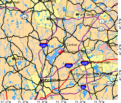
- OSM Map
- General Map
- Google Map
- MSN Map
Population change since 2000: +8.7%
 |
| Males: 2,091 | |
| Females: 2,264 |
| Median resident age: | 44.5 years |
| Massachusetts median age: | 39.2 years |
Zip codes: 01505.
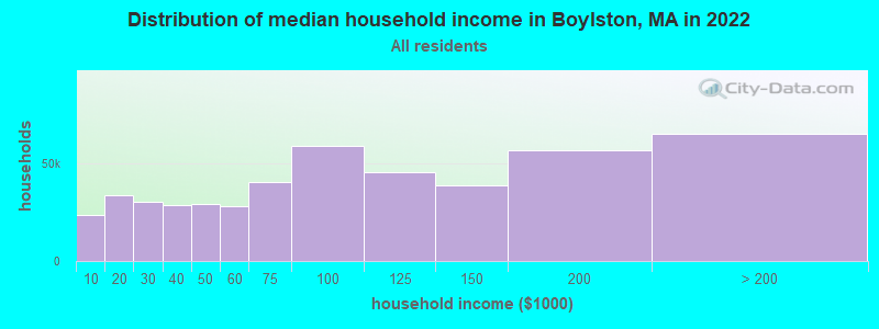
| Boylston: | $121,985 |
| MA: | $94,488 |
Estimated per capita income in 2022: $62,927 (it was $32,274 in 2000)
Boylston town income, earnings, and wages data
Estimated median house or condo value in 2022: $485,208 (it was $175,700 in 2000)
| Boylston: | $485,208 |
| MA: | $534,700 |
Mean prices in 2022: all housing units: $419,164; detached houses: $447,621; townhouses or other attached units: $343,592; in 2-unit structures: $323,295; in 3-to-4-unit structures: $332,295; in 5-or-more-unit structures: $232,758; mobile homes: $113,885
Detailed information about poverty and poor residents in Boylston, MA


- 4,02192.3%White alone
- 1593.7%Asian alone
- 641.5%Hispanic
- 631.4%Two or more races
- 290.7%Black alone
- 90.2%American Indian alone
- 100.2%Other race alone
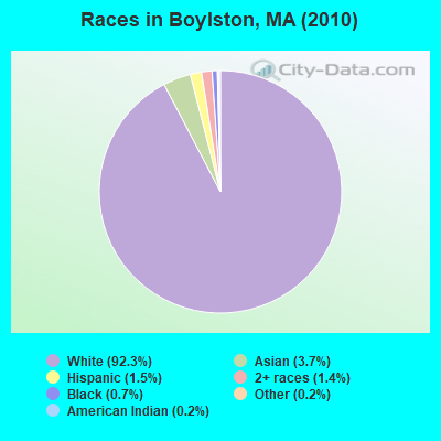
Races in Boylston detailed stats: ancestries, foreign born residents, place of birth
According to our research of Massachusetts and other state lists, there was 1 registered sex offender living in Boylston, Massachusetts as of April 16, 2024.
The ratio of all residents to sex offenders in Boylston is 4,355 to 1.
The ratio of registered sex offenders to all residents in this city is much lower than the state average.
Type |
2009 |
2010 |
2011 |
2012 |
2013 |
2014 |
2015 |
2016 |
2017 |
2018 |
2019 |
2021 |
2022 |
|---|---|---|---|---|---|---|---|---|---|---|---|---|---|
| Murders (per 100,000) | 0 (0.0) | 0 (0.0) | 0 (0.0) | 0 (0.0) | 0 (0.0) | 0 (0.0) | 0 (0.0) | 0 (0.0) | 0 (0.0) | 0 (0.0) | 0 (0.0) | 0 (0.0) | 0 (0.0) |
| Rapes (per 100,000) | 0 (0.0) | 0 (0.0) | 0 (0.0) | 0 (0.0) | 0 (0.0) | 0 (0.0) | 0 (0.0) | 0 (0.0) | 0 (0.0) | 1 (21.4) | 0 (0.0) | 0 (0.0) | 0 (0.0) |
| Robberies (per 100,000) | 0 (0.0) | 0 (0.0) | 0 (0.0) | 0 (0.0) | 0 (0.0) | 0 (0.0) | 0 (0.0) | 0 (0.0) | 0 (0.0) | 0 (0.0) | 0 (0.0) | 0 (0.0) | 0 (0.0) |
| Assaults (per 100,000) | 0 (0.0) | 2 (45.9) | 2 (45.6) | 2 (45.4) | 3 (67.9) | 7 (156.8) | 4 (88.8) | 6 (131.8) | 2 (43.4) | 2 (42.8) | 4 (85.2) | 1 (20.8) | 5 (101.3) |
| Burglaries (per 100,000) | 7 (161.7) | 10 (229.6) | 19 (433.6) | 16 (362.8) | 20 (452.8) | 25 (560.2) | 17 (377.2) | 14 (307.6) | 1 (21.7) | 7 (149.8) | 0 (0.0) | 5 (104.0) | 1 (20.3) |
| Thefts (per 100,000) | 22 (508.1) | 117 (2,687) | 31 (707.4) | 15 (340.1) | 12 (271.7) | 14 (313.7) | 13 (288.4) | 7 (153.8) | 14 (303.7) | 5 (107.0) | 2 (42.6) | 14 (291.3) | 6 (121.6) |
| Auto thefts (per 100,000) | 1 (23.1) | 7 (160.7) | 0 (0.0) | 2 (45.4) | 1 (22.6) | 1 (22.4) | 1 (22.2) | 0 (0.0) | 1 (21.7) | 1 (21.4) | 0 (0.0) | 0 (0.0) | 2 (40.5) |
| Arson (per 100,000) | 0 (0.0) | 0 (0.0) | 0 (0.0) | 0 (0.0) | 0 (0.0) | 0 (0.0) | 0 (0.0) | 0 (0.0) | 0 (0.0) | 0 (0.0) | 0 (0.0) | 0 (0.0) | 0 (0.0) |
| City-Data.com crime index | 33.5 | 145.6 | 67.8 | 51.7 | 58.0 | 84.9 | 57.5 | 54.1 | 24.1 | 42.1 | 18.7 | 23.1 | 29.8 |
The City-Data.com crime index weighs serious crimes and violent crimes more heavily. Higher means more crime, U.S. average is 246.1. It adjusts for the number of visitors and daily workers commuting into cities.
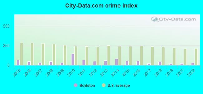
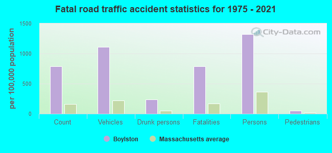
Crime rate in Boylston detailed stats: murders, rapes, robberies, assaults, burglaries, thefts, arson
Full-time law enforcement employees in 2021, including police officers: 15 (11 officers - 11 male; 0 female).
| Officers per 1,000 residents here: | 2.29 |
| Massachusetts average: | 2.53 |
 Recent articles from our blog. Our writers, many of them Ph.D. graduates or candidates, create easy-to-read articles on a wide variety of topics.

 | Any signs yet of the propsed Trader Joe's at 500 Boylston in Copley? (1 reply) |
| The demise of Boylston Street (September 2020) (109 replies) |
| Yep, two more banks coming to Boylston Syteet in the Back Bay (March 2022) (22 replies) |
| November 2022...closed restaurants, bars and shops (201 replies) |
| MBTA in a state of disrepair. (1013 replies) |
| "All-Inclusive Boston" campaiagn (582 replies) |
Latest news from Boylston, MA collected exclusively by city-data.com from local newspapers, TV, and radio stations
Boylston, MA City Guides:
Ancestries: Irish (26.5%), English (18.0%), Italian (13.8%), German (9.6%), French (8.8%), French Canadian (8.1%).
Current Local Time: EST time zone
Incorporated in 1785
Elevation: 443 feet
Land area: 16.0 square miles.
Population density: 272 people per square mile (very low).
208 residents are foreign born (1.7% Europe, 1.6% Asia, 1.3% North America).
| This town: | 5.2% |
| Massachusetts: | 12.2% |
| Boylston town: | 1.5% ($2,621) |
| Massachusetts: | 1.3% ($2,336) |
Nearest city with pop. 50,000+: Worcester, MA  (6.1 miles , pop. 172,648).
Nearest city with pop. 200,000+: Boston, MA (32.8 miles , pop. 589,141).
Nearest city with pop. 1,000,000+: Bronx, NY (151.4 miles , pop. 1,332,650).
Nearest cities:
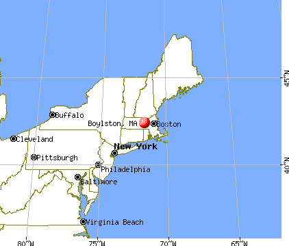
Latitude: 42.34 N, Longitude: 71.73 W
Area codes: 508, 774

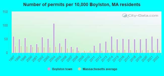
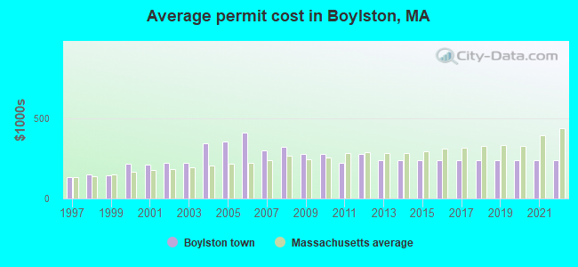
Single-family new house construction building permits:
- 2022: 21 buildings, average cost: $239,100
- 2021: 24 buildings, average cost: $239,100
- 2020: 21 buildings, average cost: $239,100
- 2019: 20 buildings, average cost: $239,100
- 2018: 20 buildings, average cost: $239,100
- 2017: 20 buildings, average cost: $239,100
- 2016: 21 buildings, average cost: $239,100
- 2015: 20 buildings, average cost: $239,100
- 2014: 24 buildings, average cost: $239,100
- 2013: 17 buildings, average cost: $239,100
- 2012: 14 buildings, average cost: $275,800
- 2011: 11 buildings, average cost: $220,300
- 2010: 1 building, cost: $275,000
- 2009: 1 building, cost: $275,000
- 2008: 8 buildings, average cost: $323,300
- 2007: 9 buildings, average cost: $297,100
- 2006: 21 buildings, average cost: $407,200
- 2005: 14 buildings, average cost: $355,000
- 2004: 43 buildings, average cost: $341,100
- 2003: 21 buildings, average cost: $221,100
- 2002: 23 buildings, average cost: $223,000
- 2001: 13 buildings, average cost: $208,400
- 2000: 12 buildings, average cost: $217,700
- 1999: 22 buildings, average cost: $145,100
- 1998: 20 buildings, average cost: $150,800
- 1997: 24 buildings, average cost: $130,000
| Here: | 3.5% |
| Massachusetts: | 3.5% |
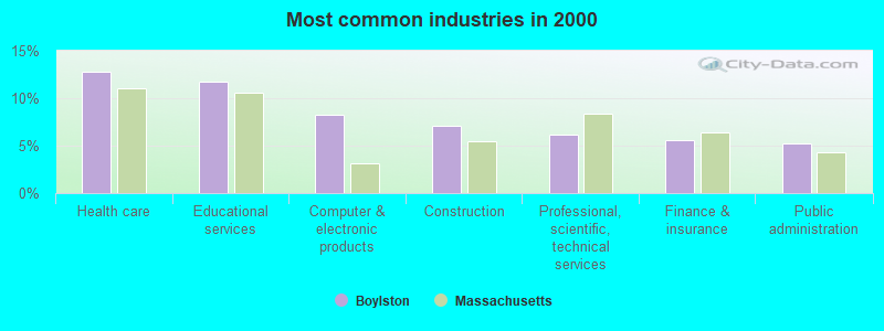
- Health care (12.8%)
- Educational services (11.7%)
- Computer & electronic products (8.2%)
- Construction (7.0%)
- Professional, scientific, technical services (6.1%)
- Finance & insurance (5.6%)
- Public administration (5.2%)
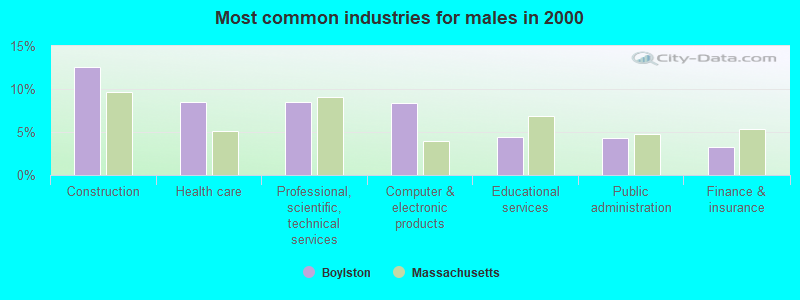
- Construction (12.5%)
- Health care (8.5%)
- Professional, scientific, technical services (8.5%)
- Computer & electronic products (8.4%)
- Educational services (4.4%)
- Public administration (4.3%)
- Finance & insurance (3.2%)
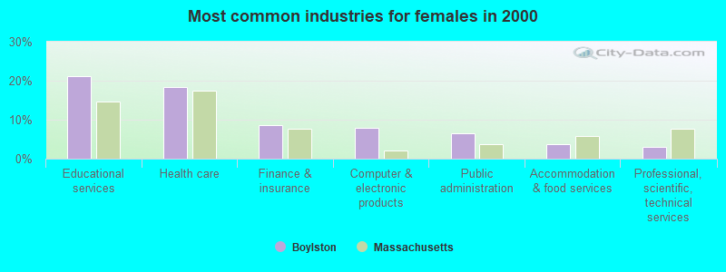
- Educational services (21.1%)
- Health care (18.4%)
- Finance & insurance (8.7%)
- Computer & electronic products (8.0%)
- Public administration (6.5%)
- Accommodation & food services (3.6%)
- Professional, scientific, technical services (3.1%)
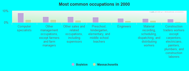
- Computer specialists (8.4%)
- Other management occupations, except farmers and farm managers (5.2%)
- Other sales and related occupations, including supervisors (5.0%)
- Preschool, kindergarten, elementary, and middle school teachers (4.7%)
- Engineers (3.7%)
- Material recording, scheduling, dispatching, and distributing workers (3.4%)
- Construction traders workers except carpenters, electricians, painters, plumbers, and construction laborers (3.1%)
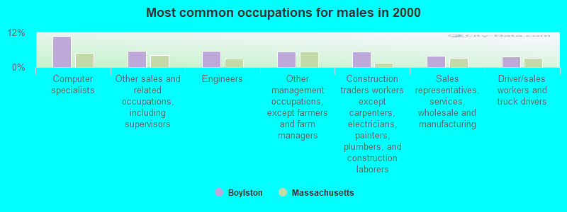
- Computer specialists (10.9%)
- Other sales and related occupations, including supervisors (5.7%)
- Engineers (5.5%)
- Other management occupations, except farmers and farm managers (5.4%)
- Construction traders workers except carpenters, electricians, painters, plumbers, and construction laborers (5.4%)
- Sales representatives, services, wholesale and manufacturing (4.0%)
- Driver/sales workers and truck drivers (3.7%)
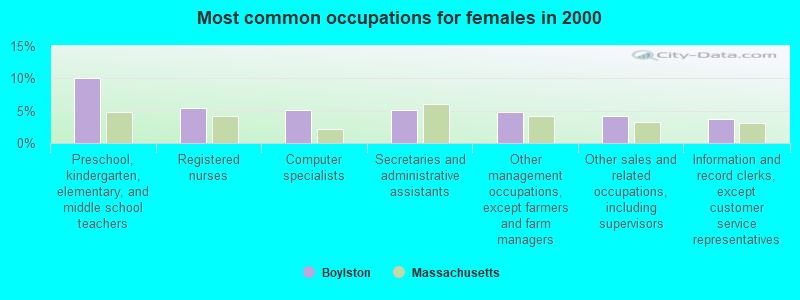
- Preschool, kindergarten, elementary, and middle school teachers (10.1%)
- Registered nurses (5.5%)
- Computer specialists (5.2%)
- Secretaries and administrative assistants (5.2%)
- Other management occupations, except farmers and farm managers (4.8%)
- Other sales and related occupations, including supervisors (4.2%)
- Information and record clerks, except customer service representatives (3.7%)
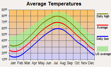
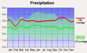
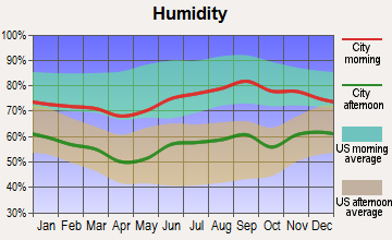
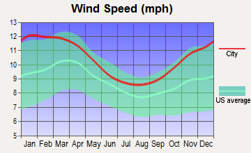
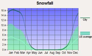
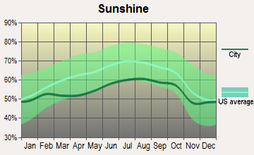
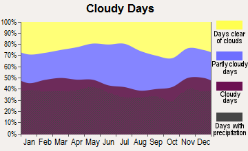
Average climate in Boylston, Massachusetts
Based on data reported by over 4,000 weather stations
(lower is better)
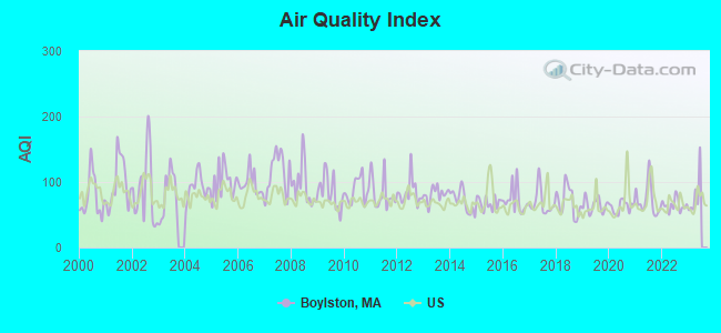
Air Quality Index (AQI) level in 2022 was 64.6. This is about average.
| City: | 64.6 |
| U.S.: | 72.6 |
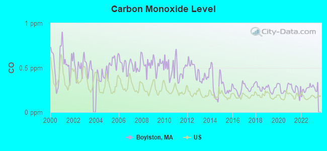
Carbon Monoxide (CO) [ppm] level in 2022 was 0.259. This is about average. Closest monitor was 6.0 miles away from the city center.
| City: | 0.259 |
| U.S.: | 0.251 |
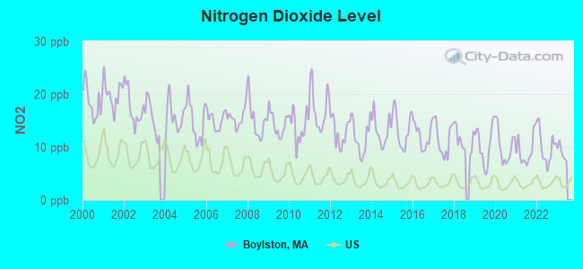
Nitrogen Dioxide (NO2) [ppb] level in 2022 was 10.1. This is significantly worse than average. Closest monitor was 4.6 miles away from the city center.
| City: | 10.1 |
| U.S.: | 5.1 |
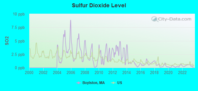
Sulfur Dioxide (SO2) [ppb] level in 2022 was 0.370. This is significantly better than average. Closest monitor was 4.6 miles away from the city center.
| City: | 0.370 |
| U.S.: | 1.515 |
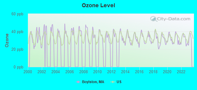
Ozone [ppb] level in 2022 was 31.4. This is about average. Closest monitor was 4.6 miles away from the city center.
| City: | 31.4 |
| U.S.: | 33.3 |
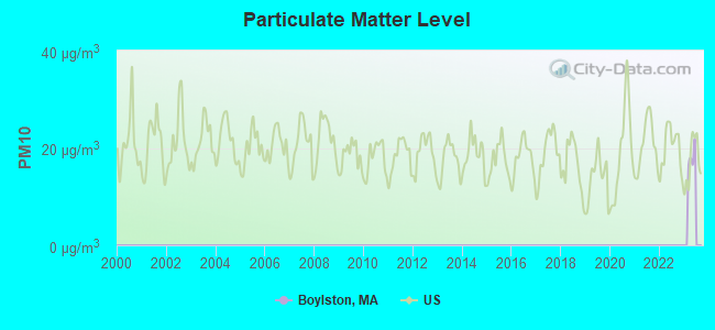
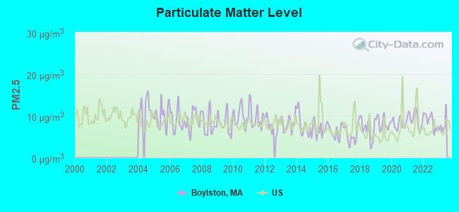
Particulate Matter (PM2.5) [µg/m3] level in 2022 was 8.71. This is about average. Closest monitor was 6.1 miles away from the city center.
| City: | 8.71 |
| U.S.: | 8.11 |
Tornado activity:
Boylston-area historical tornado activity is slightly above Massachusetts state average. It is 21% smaller than the overall U.S. average.
On 6/9/1953, a category F4 (max. wind speeds 207-260 mph) tornado 11.1 miles away from the Boylston town center killed 90 people and injured 1228 people and caused between $50,000,000 and $500,000,000 in damages.
On 6/9/1953, a category F3 (max. wind speeds 158-206 mph) tornado 11.8 miles away from the town center injured 17 people and caused between $500,000 and $5,000,000 in damages.
Earthquake activity:
Boylston-area historical earthquake activity is significantly above Massachusetts state average. It is 72% smaller than the overall U.S. average.On 10/7/1983 at 10:18:46, a magnitude 5.3 (5.1 MB, 5.3 LG, 5.1 ML, Class: Moderate, Intensity: VI - VII) earthquake occurred 172.7 miles away from the city center
On 4/20/2002 at 10:50:47, a magnitude 5.3 (5.3 ML, Depth: 3.0 mi) earthquake occurred 179.9 miles away from the city center
On 4/20/2002 at 10:50:47, a magnitude 5.2 (5.2 MB, 4.2 MS, 5.2 MW, 5.0 MW) earthquake occurred 179.0 miles away from Boylston center
On 1/19/1982 at 00:14:42, a magnitude 4.7 (4.5 MB, 4.7 MD, 4.5 LG, Class: Light, Intensity: IV - V) earthquake occurred 80.6 miles away from Boylston center
On 10/16/2012 at 23:12:25, a magnitude 4.7 (4.7 ML, Depth: 10.0 mi) earthquake occurred 102.7 miles away from Boylston center
On 8/22/1992 at 12:20:32, a magnitude 4.8 (4.8 MB, 3.8 MS, 4.7 LG, Depth: 6.2 mi) earthquake occurred 235.5 miles away from Boylston center
Magnitude types: regional Lg-wave magnitude (LG), body-wave magnitude (MB), duration magnitude (MD), local magnitude (ML), surface-wave magnitude (MS), moment magnitude (MW)
Natural disasters:
The number of natural disasters in Worcester County (27) is a lot greater than the US average (15).Major Disasters (Presidential) Declared: 15
Emergencies Declared: 12
Causes of natural disasters: Floods: 9, Storms: 8, Hurricanes: 6, Snowstorms: 5, Winter Storms: 4, Blizzards: 2, Snows: 2, Fire: 1, Heavy Rain: 1, Snowfall: 1, Tornado: 1, Wind: 1 (Note: some incidents may be assigned to more than one category).

Hospitals and medical centers in Boylston:
Other hospitals and medical centers near Boylston:
- KNOLLWOOD NURSING CENTER (Nursing Home, about 3 miles away; WORCESTER, MA)
- UMASS MEMORIAL HOME HEALTH (Home Health Center, about 4 miles away; WORCESTER, MA)
- UMASS MEMORIAL HOSPICE (Hospital, about 4 miles away; WORCESTER, MA)
- AUTUMN VILLAGE, LLC (Nursing Home, about 4 miles away; WORCESTER, MA)
- SALISBURY N H (Nursing Home, about 4 miles away; WORCESTER, MA)
- SHREWSBURY NURSING AND REHABILITATION CENTER (Nursing Home, about 4 miles away; SHREWSBURY, MA)
- MEDI STAFF CORP (Home Health Center, about 4 miles away; WORCESTER, MA)
Amtrak stations near Boylston:
- 7 miles: WORCESTER (WORCHESTER, 45 SHREWSBURY ST.) . Services: ticket office, fully wheelchair accessible, enclosed waiting area, public restrooms, public payphones, vending machines, free short-term parking, free long-term parking, call for taxi service, public transit connection.
- 17 miles: FRAMINGHAM (443 WAVERLY ST.) . Services: public payphones, snack bar, paid short-term parking, taxi stand, public transit connection.
Colleges/universities with over 2000 students nearest to Boylston:
- Quinsigamond Community College (about 4 miles; Worcester, MA; Full-time enrollment: 5,877)
- Assumption College (about 6 miles; Worcester, MA; FT enrollment: 2,580)
- Worcester Polytechnic Institute (about 6 miles; Worcester, MA; FT enrollment: 3,930)
- Worcester State University (about 8 miles; Worcester, MA; FT enrollment: 5,426)
- Clark University (about 8 miles; Worcester, MA; FT enrollment: 3,687)
- College of the Holy Cross (about 8 miles; Worcester, MA; FT enrollment: 3,125)
- Framingham State University (about 16 miles; Framingham, MA; FT enrollment: 5,743)
Public high school in Boylston:
- TAHANTO REGIONAL HIGH (Students: 488, Location: 1001 MAIN STREET, Grades: 6-12)
Public elementary/middle school in Boylston:
- BOYLSTON ELEMENTARY (Students: 377, Location: 200 SEWALL STREET, Grades: PK-5)
Points of interest:
Notable locations in Boylston: Mount Pleasant Country Club (A), Boylston Fire Department (B), Worcester County House of Correction and Jail Library (C), Tower Hill Botanic Garden Library (D), Boylston Town Offices (E). Display/hide their locations on the map
Cemetery: Pine Grove Cemetery (1). Display/hide its location on the map
Lakes and swamps: Pout Pond (A), Rocky Pond (B), Sewall Pond (C), Spruce Pond (D), Cushing Swamp (E), Pine Swamp (F), Scotland Swamp (G), Straw Hollow (H). Display/hide their locations on the map
Streams, rivers, and creeks: French Brook (A), Malagasco Brook (B), Potash Brook (C), Rawson Hill Brook (D), Wekepeke Brook (E), Lamson Brook (F). Display/hide their locations on the map
Birthplace of: Jeff Fuller (racing driver) - Racing driver, David Lee Child - Abolitionist, Eliakim H. Moore - Politician, Marcus Child - Politician, William N. Davenport - Politician.
Drinking water stations with addresses in Boylston and their reported violations in the past:
BOYLSTON WATER DISTRICT (Population served: 3,040, Groundwater):Past health violations:MEADOWBROOK VILLAGE CONDOMINIUMS (Address: 120 SHREWSBURY STREET , Population served: 150, Groundwater):Past monitoring violations:
- MCL, Monthly (TCR) - In JUN-2014, Contaminant: Coliform. Follow-up actions: St AO (w/o penalty) issued (SEP-09-2014)
- MCL, Monthly (TCR) - In MAY-2014, Contaminant: Coliform. Follow-up actions: St AO (w/o penalty) issued (SEP-09-2014)
- MCL, Monthly (TCR) - In DEC-2013, Contaminant: Coliform. Follow-up actions: St AO (w/o penalty) issued (FEB-21-2014), St Compliance achieved (JUL-23-2014)
- MCL, Monthly (TCR) - In OCT-2013, Contaminant: Coliform. Follow-up actions: St AO (w/o penalty) issued (DEC-20-2013), St Compliance achieved (JUL-23-2014)
- MCL, Monthly (TCR) - In SEP-2013, Contaminant: Coliform. Follow-up actions: St AO (w/o penalty) issued (OCT-25-2013), St Compliance achieved (OCT-25-2013)
- MCL, Monthly (TCR) - In JUL-2013, Contaminant: Coliform. Follow-up actions: St AO (w/o penalty) issued (SEP-09-2013)
- 3 other older health violations
- Follow-up Or Routine LCR Tap M/R - In JUL-01-2013, Contaminant: Lead and Copper Rule. Follow-up actions: St AO (w/o penalty) issued (NOV-26-2013)
- 3 minor monitoring violations
- One regular monitoring violation
Past monitoring violations:PINEWOOD ON THE GREEN CONDOS (Address: 120 SHREWSBURY STREET , Population served: 50, Groundwater):
- Follow-up Or Routine LCR Tap M/R - In JUL-01-2009, Contaminant: Lead and Copper Rule. Follow-up actions: St AO (w/o penalty) issued (DEC-14-2009), St Compliance achieved (DEC-09-2010)
- 52 regular monitoring violations
Past health violations:Past monitoring violations:
- MCL, Average - Between JAN-2007 and MAR-2007, Contaminant: Arsenic. Follow-up actions: St AO (w/o penalty) issued (AUG-09-2007), St Compliance achieved (AUG-09-2007)
- MCL, Average - Between OCT-2006 and DEC-2006, Contaminant: Arsenic. Follow-up actions: St AO (w/o penalty) issued (FEB-06-2007)
- MCL, Average - Between JUL-2006 and SEP-2006, Contaminant: Arsenic. Follow-up actions: St AO (w/o penalty) issued (NOV-14-2006)
- Monitoring and Reporting (DBP) - Between JUL-2013 and SEP-2013, Contaminant: Chlorine. Follow-up actions: St AO (w/o penalty) issued (NOV-26-2013), St Compliance achieved (NOV-26-2013)
- One minor monitoring violation
| This town: | 2.6 people |
| Massachusetts: | 2.5 people |
| This town: | 72.5% |
| Whole state: | 63.0% |
| This town: | 4.9% |
| Whole state: | 7.0% |
Likely homosexual households (counted as self-reported same-sex unmarried-partner households)
- Lesbian couples: 0.5% of all households
- Gay men: 0.3% of all households
| This town: | 2.8% |
| Whole state: | 9.3% |
| This town: | 1.5% |
| Whole state: | 4.4% |
4 people in workers' group living quarters and job corps centers in 2010
Banks with branches in Boylston (2011 data):
- Clinton Savings Bank: Boylston Branch at 81 D Shrewsbury Street, branch established on 2005/10/18. Info updated 2012/04/03: Bank assets: $479.5 mil, Deposits: $362.7 mil, headquarters in Clinton, MA, positive income, Mortgage Lending Specialization, 7 total offices, Holding Company: Clinton Financial Services, Mhc
For population 15 years and over in Boylston:
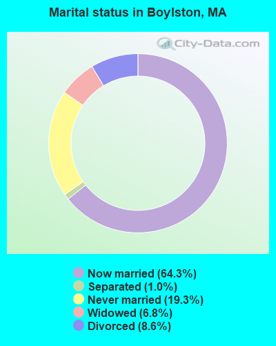
- Never married: 19.3%
- Now married: 64.3%
- Separated: 1.0%
- Widowed: 6.8%
- Divorced: 8.6%
For population 25 years and over in Boylston:
- High school or higher: 93.0%
- Bachelor's degree or higher: 37.7%
- Graduate or professional degree: 15.4%
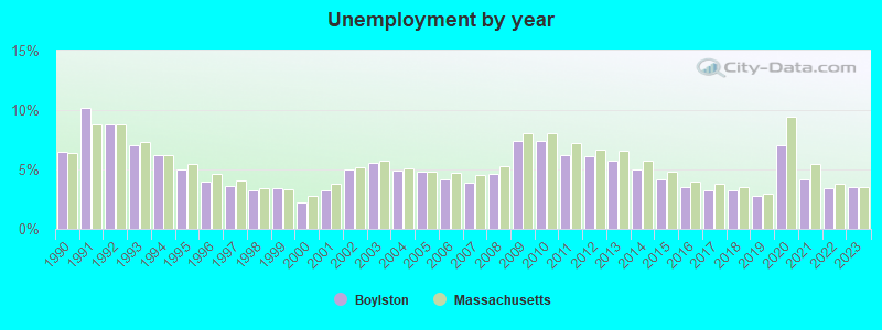
- Unemployed: 0.9%
- Mean travel time to work (commute): 25.8 minutes
| Here: | 10.2 |
| Massachusetts average: | 13.1 |


Graphs represent county-level data. Detailed 2008 Election Results
Religion statistics for Boylston, MA (based on Worcester County data)


| Religion | Adherents | Congregations |
|---|---|---|
| Catholic | 306,925 | 118 |
| Mainline Protestant | 43,326 | 171 |
| Evangelical Protestant | 37,511 | 203 |
| Other | 18,931 | 69 |
| Orthodox | 7,935 | 15 |
| Black Protestant | 497 | 6 |
| None | 383,427 | - |
Food Environment Statistics:
| Worcester County: | 1.73 / 10,000 pop. |
| State: | 1.98 / 10,000 pop. |
| Here: | 0.05 / 10,000 pop. |
| Massachusetts: | 0.05 / 10,000 pop. |
| This county: | 1.79 / 10,000 pop. |
| Massachusetts: | 2.22 / 10,000 pop. |
| This county: | 2.22 / 10,000 pop. |
| Massachusetts: | 1.77 / 10,000 pop. |
| Worcester County: | 7.27 / 10,000 pop. |
| Massachusetts: | 8.76 / 10,000 pop. |
| Worcester County: | 8.0% |
| Massachusetts: | 8.1% |
| Worcester County: | 24.0% |
| Massachusetts: | 22.5% |
| Here: | 16.6% |
| State: | 16.5% |
4.71% of this county's 2021 resident taxpayers lived in other counties in 2020 ($76,229 average adjusted gross income)
| Here: | 4.71% |
| Massachusetts average: | 6.35% |
0.02% of residents moved from foreign countries ($100 average AGI)
Worcester County: 0.02% Massachusetts average: 0.01%
Top counties from which taxpayers relocated into this county between 2020 and 2021:
| from Middlesex County, MA | |
| from Norfolk County, MA | |
| from Suffolk County, MA |
4.84% of this county's 2020 resident taxpayers moved to other counties in 2021 ($87,252 average adjusted gross income)
| Here: | 4.84% |
| Massachusetts average: | 7.18% |
0.03% of residents moved to foreign countries ($199 average AGI)
Worcester County: 0.03% Massachusetts average: 0.02%
Top counties to which taxpayers relocated from this county between 2020 and 2021:
| to Middlesex County, MA | |
| to Norfolk County, MA | |
| to Suffolk County, MA |
Businesses in Boylston, MA
- Dunkin Donuts: 1
Strongest AM radio stations in Boylston:
- WCRN (830 AM; 50 kW; WORCESTER, MA; Owner: CARTER BROADCASTING CORPORATION)
- WTAG (580 AM; 5 kW; WORCESTER, MA; Owner: CAPSTAR TX LIMITED PARTNERSHIP)
- WKOX (1200 AM; 50 kW; FRAMINGHAM, MA; Owner: CAPSTAR TX LIMITED PARTNERSHIP)
- WBIX (1060 AM; 40 kW; NATICK, MA; Owner: LANGER BROADCASTING CORPORATION)
- WEEI (850 AM; 50 kW; BOSTON, MA; Owner: ENTERCOM BOSTON LICENSE, LLC)
- WAMG (890 AM; 25 kW; DEDHAM, MA; Owner: MEGA COMMUNICATIONS OF DEDHAM LICENSEE, LLC)
- WVNE (760 AM; daytime; 25 kW; LEICESTER, MA; Owner: BLOUNT MASSCOM, INC.)
- WRKO (680 AM; 50 kW; BOSTON, MA; Owner: ENTERCOM BOSTON LICENSE, LLC)
- WVEI (1440 AM; 5 kW; WORCESTER, MA; Owner: ENTERCOM BOSTON LICENSE, LLC)
- WAZN (1470 AM; 7 kW; MARLBOROUGH, MA; Owner: MULTICULTURAL RADIO BROADCASTING, INC.)
- WALE (990 AM; 50 kW; GREENVILLE, RI; Owner: NORTH AMERICAN BROADCASTING CO., INC.)
- WORC (1310 AM; 5 kW; WORCESTER, MA; Owner: CHOWDER BROADCAST GROUP LLC)
- WWZN (1510 AM; 50 kW; BOSTON, MA; Owner: ROSE CITY RADIO CORPORATION)
Strongest FM radio stations in Boylston:
- WAAF (107.3 FM; WORCESTER, MA; Owner: ENTERCOM BOSTON LICENSE, LLC)
- WSRS (96.1 FM; WORCESTER, MA; Owner: CAPSTAR TX LIMITED PARTNERSHIP)
- WICN (90.5 FM; WORCESTER, MA; Owner: WICN PUBLIC RADIO, INC)
- WXLO (104.5 FM; FITCHBURG, MA; Owner: CITADEL BROADCASTING COMPANY)
- WBMX (98.5 FM; BOSTON, MA; Owner: INFINITY RADIO OPERATIONS INC.)
- WJMN (94.5 FM; BOSTON, MA; Owner: AMFM RADIO LICENSES, L.L.C.)
- WCRB (102.5 FM; WALTHAM, MA; Owner: CHARLES RIVER BROADCASTING WCRB LICE)
- WTKK (96.9 FM; BOSTON, MA; Owner: GREATER BOSTON RADIO, INC.)
- WROR-FM (105.7 FM; FRAMINGHAM, MA; Owner: GREATER BOSTON RADIO, INC.)
- WBOS (92.9 FM; BROOKLINE, MA; Owner: GREATER BOSTON RADIO, INC.)
- WGBH (89.7 FM; BOSTON, MA; Owner: WGBH EDUCATIONAL FOUNDATION)
- WBUR-FM (90.9 FM; BOSTON, MA; Owner: TRUSTEES OF BOSTON UNIVERSITY)
- WCUW (91.3 FM; WORCESTER, MA; Owner: WUW, INC.)
- WODS (103.3 FM; BOSTON, MA; Owner: INFINITY BROADCASTING OPERATIONS, INC.)
- WFEX (92.1 FM; PETERBOROUGH, NH; Owner: FNX BROADCASTING OF NEW HAMPSHIRE LLC)
- WXKS-FM (107.9 FM; MEDFORD, MA; Owner: AMFM RADIO LICENSES, L.L.C.)
- WMJX (106.7 FM; BOSTON, MA; Owner: GREATER BOSTON RADIO, INC.)
- WBPR (91.9 FM; WORCESTER, MA; Owner: UNIVERSITY OF MASSACHUSETTS)
- WFCR (88.5 FM; AMHERST, MA; Owner: UNIVERSITY OF MASSACHUSETTS)
- WYCM (90.1 FM; CHARLTON, MA; Owner: BAY PATH VOCATIONAL HIGH SCHOOL)
TV broadcast stations around Boylston:
- WUNI (Channel 27; WORCESTER, MA; Owner: ENTRAVISION HOLDINGS, LLC)
- WUTF (Channel 66; MARLBOROUGH, MA; Owner: TELEFUTURA BOSTON LLC)
- WCVB-TV (Channel 5; BOSTON, MA; Owner: WCVB HEARST-ARGYLE TV, INC.)
- WGBH-TV (Channel 2; BOSTON, MA; Owner: WGBH EDUCATIONAL FOUNDATION)
- WMFP (Channel 62; LAWRENCE, MA; Owner: WSAH LICENSE, INC.)
- WHDH-TV (Channel 7; BOSTON, MA; Owner: WHDH-TV)
- WBZ-TV (Channel 4; BOSTON, MA; Owner: VIACOM INC.)
- WGBX-TV (Channel 44; BOSTON, MA; Owner: WGBH EDUCATIONAL FOUNDATION)
- WSBK-TV (Channel 38; BOSTON, MA; Owner: VIACOM INC.)
- WLVI-TV (Channel 56; CAMBRIDGE, MA; Owner: WLVI, INC.)
- WFXT (Channel 25; BOSTON, MA; Owner: FOX TELEVISION STATIONS INC.)
- WYDN (Channel 48; WORCESTER, MA; Owner: EDUCATIONAL PUBLIC TV CORPORATION)
- WCRN-LP (Channel 34; LEICESTER, MA; Owner: CARTER BROADCASTING CORPORATION)
- W40BO (Channel 40; BOSTON, MA; Owner: PAXSON COMMUNICATIONS LPTV, INC.)
- WBPX (Channel 68; BOSTON, MA; Owner: PAXSON BOSTON-68 LICENSE, INC.)
- WTMU-LP (Channel 32; BOSTON, MA; Owner: ZGS BOSTON, INC.)
- WPXQ (Channel 69; BLOCK ISLAND, RI; Owner: OCEAN STATE TELEVISION, L.L.C.)
- WCEA-LP (Channel 58; BOSTON, MA; Owner: CHANNEL 19 TV CORPORATION)
- WNAC-TV (Channel 64; PROVIDENCE, RI; Owner: WNAC, LLC)
- WWDP (Channel 46; NORWELL, MA; Owner: NORWELL TELEVISION, LLC)
- WPRI-TV (Channel 12; PROVIDENCE, RI; Owner: TVL BROADCASTING OF RHODE ISLAND, LLC)
- WLNE-TV (Channel 6; NEW BEDFORD, MA; Owner: FREEDOM BROADCASTING OF SOUTHERN NEW ENGLAND, INC.)
- WFXZ-CA (Channel 24; BOSTON, MA; Owner: BOSTON BROADCASTING CORP.)
- WJAR (Channel 10; PROVIDENCE, RI; Owner: OUTLET BROADCASTING, INC.)
- National Bridge Inventory (NBI) Statistics
- 4Number of bridges
- 23ft / 6.8mTotal length
- $5,704,000Total costs
- 78,547Total average daily traffic
- 3,663Total average daily truck traffic
FCC Registered Commercial Land Mobile Towers: 1 (See the full list of FCC Registered Commercial Land Mobile Towers in Boylston, MA)
FCC Registered Private Land Mobile Towers: 1 (See the full list of FCC Registered Private Land Mobile Towers)
FCC Registered Broadcast Land Mobile Towers: 10 (See the full list of FCC Registered Broadcast Land Mobile Towers)
FCC Registered Microwave Towers: 5 (See the full list of FCC Registered Microwave Towers in this town)
FCC Registered Paging Towers: 3 (See the full list of FCC Registered Paging Towers)
FCC Registered Amateur Radio Licenses: 32 (See the full list of FCC Registered Amateur Radio Licenses in Boylston)
FAA Registered Aircraft: 9 (See the full list of FAA Registered Aircraft in Boylston)
2002 - 2018 National Fire Incident Reporting System (NFIRS) incidents
- Fire incident types reported to NFIRS in Boylston, MA
- 9448.7%Structure Fires
- 6232.1%Outside Fires
- 2613.5%Mobile Property/Vehicle Fires
- 115.7%Other
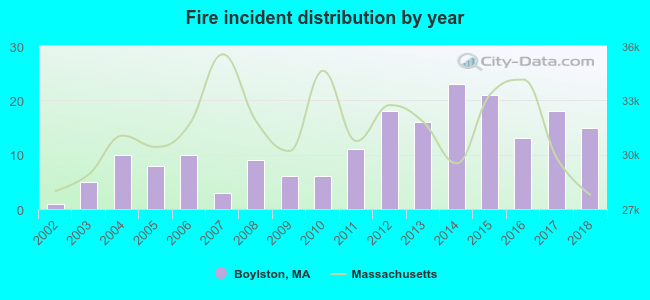 According to the data from the years 2002 - 2018 the average number of fire incidents per year is 11. The highest number of reported fires - 23 took place in 2014, and the least - 1 in 2002. The data has a rising trend.
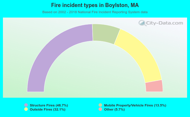 When looking into fire subcategories, the most reports belonged to: Structure Fires (48.7%), and Outside Fires (32.1%).
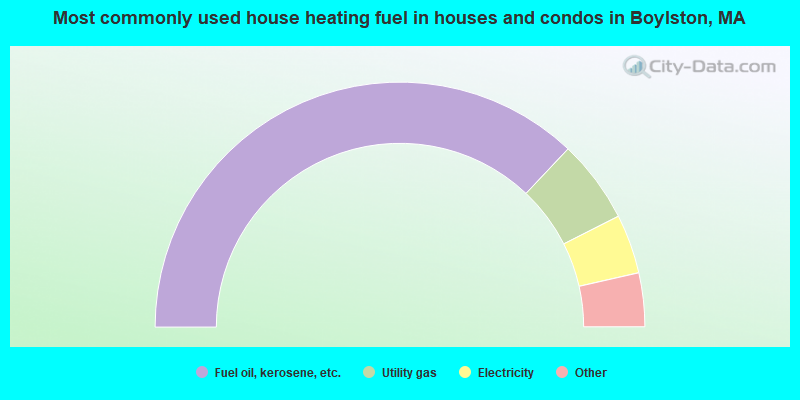
- 74.0%Fuel oil, kerosene, etc.
- 11.0%Utility gas
- 7.8%Electricity
- 3.9%Wood
- 2.7%Bottled, tank, or LP gas
- 0.5%Coal or coke
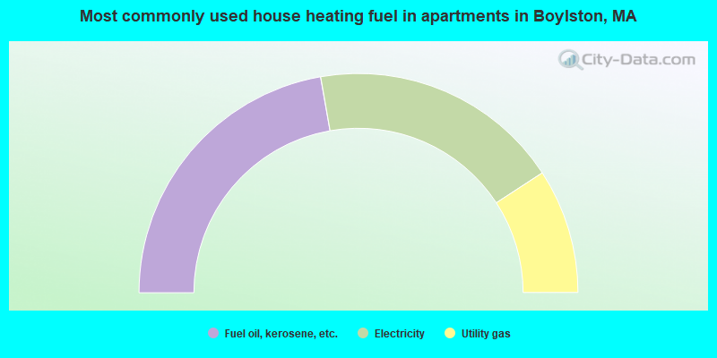
- 44.5%Fuel oil, kerosene, etc.
- 37.1%Electricity
- 18.4%Utility gas
Boylston compared to Massachusetts state average:
- Unemployed percentage significantly below state average.
- Black race population percentage significantly below state average.
- Hispanic race population percentage significantly below state average.
- Median age above state average.
- Foreign-born population percentage significantly below state average.
- Renting percentage significantly below state average.
- Length of stay since moving in significantly above state average.
- Number of rooms per house significantly below state average.
- House age significantly below state average.

|
|
Total of 201 patent applications in 2008-2024.