Bridger Valley, Wyoming
Submit your own pictures of this place and show them to the world
- OSM Map
- General Map
- Google Map
- MSN Map

| Males: 3,150 | |
| Females: 2,938 |
| Median resident age: | 32.5 years |
| Wyoming median age: | 36.2 years |
Zip code: 82937
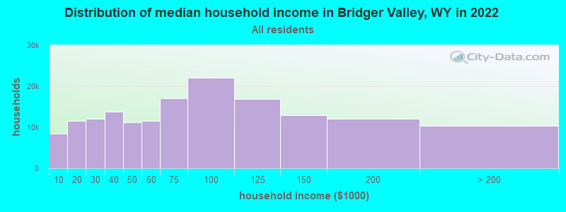
| Bridger Valley: | $84,907 |
| WY: | $70,042 |
Estimated per capita income in 2022: $33,198 (it was $17,763 in 2000)
Bridger Valley CCD income, earnings, and wages data
Estimated median house or condo value in 2022: $244,620 (it was $84,100 in 2000)
| Bridger Valley: | $244,620 |
| WY: | $292,300 |
Bridger Valley, WY residents, houses, and apartments details
Detailed information about poverty and poor residents in Bridger Valley, WY


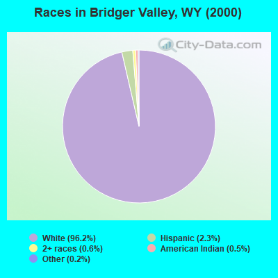
- 5,73996.2%White alone
- 1402.3%Hispanic
- 380.6%Two or more races
- 270.5%American Indian alone
- 100.2%Other race alone
- 50.08%Asian alone
- 30.05%Black alone
- 20.03%Native Hawaiian and Other
Pacific Islander alone
Races in Bridger Valley detailed stats: ancestries, foreign born residents, place of birth
 Recent articles from our blog. Our writers, many of them Ph.D. graduates or candidates, create easy-to-read articles on a wide variety of topics.
Current Local Time: MST time zone
Land area: 1140.3 square miles.
Population density: 5.3 people per square mile (very low).

| Bridger Valley CCD: | 0.7% ($598) |
| Wyoming: | 0.7% ($627) |
Nearest city with pop. 50,000+: Ogden, UT  (83.9 miles , pop. 77,226).
Nearest city with pop. 200,000+: Northeast Jefferson, CO (296.2 miles , pop. 450,166).
Nearest city with pop. 1,000,000+: Phoenix, AZ (546.8 miles , pop. 1,321,045).
Nearest cities:
), ), ), Latitude: 41.31 N, Longitude: 110.35 W
Area code commonly used in this area: 307

| Here: | 2.8% |
| Wyoming: | 2.5% |
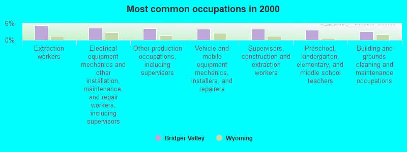
- Extraction workers (5.3%)
- Electrical equipment mechanics and other installation, maintenance, and repair workers, including supervisors (4.4%)
- Other production occupations, including supervisors (4.2%)
- Vehicle and mobile equipment mechanics, installers, and repairers (4.1%)
- Supervisors, construction and extraction workers (4.0%)
- Preschool, kindergarten, elementary, and middle school teachers (3.7%)
- Building and grounds cleaning and maintenance occupations (3.2%)
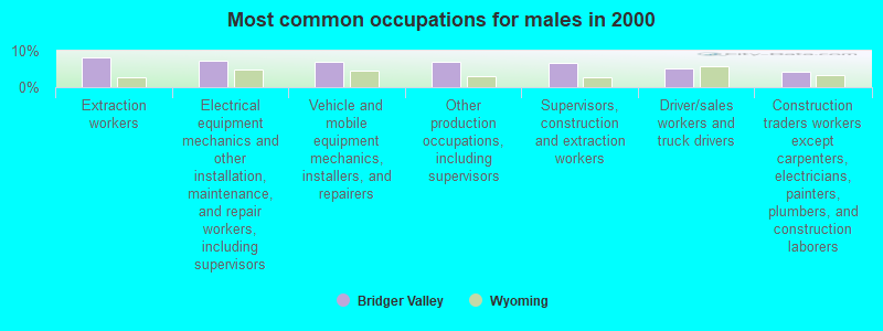
- Extraction workers (8.2%)
- Electrical equipment mechanics and other installation, maintenance, and repair workers, including supervisors (7.3%)
- Vehicle and mobile equipment mechanics, installers, and repairers (6.9%)
- Other production occupations, including supervisors (6.9%)
- Supervisors, construction and extraction workers (6.7%)
- Driver/sales workers and truck drivers (5.0%)
- Construction traders workers except carpenters, electricians, painters, plumbers, and construction laborers (4.2%)
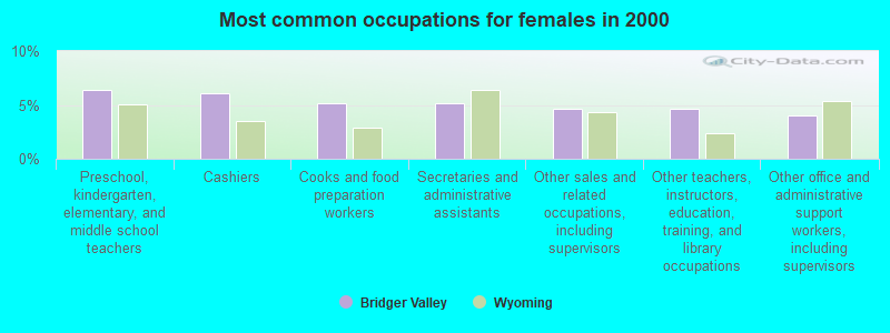
- Preschool, kindergarten, elementary, and middle school teachers (6.4%)
- Cashiers (6.1%)
- Cooks and food preparation workers (5.2%)
- Secretaries and administrative assistants (5.2%)
- Other sales and related occupations, including supervisors (4.6%)
- Other teachers, instructors, education, training, and library occupations (4.6%)
- Other office and administrative support workers, including supervisors (4.0%)
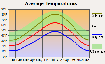
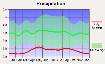
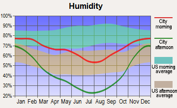
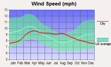
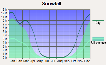
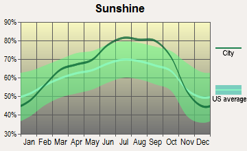
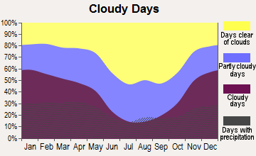
Average climate in Bridger Valley, Wyoming
Based on data reported by over 4,000 weather stations
Earthquake activity:
Bridger Valley-area historical earthquake activity is significantly above Wyoming state average. It is 1682% greater than the overall U.S. average.On 8/18/1959 at 06:37:13, a magnitude 7.7 (7.7 UK, Class: Major, Intensity: VIII - XII) earthquake occurred 225.4 miles away from the city center, causing $26,000,000 total damage
On 10/28/1983 at 14:06:06, a magnitude 7.3 (6.2 MB, 7.3 MS, 7.0 MW) earthquake occurred 259.3 miles away from Bridger Valley center, causing 2 deaths (2 shaking deaths) and 3 injuries, causing $15,000,000 total damage
On 10/3/1915 at 06:52:48, a magnitude 7.6 (7.6 UK) earthquake occurred 377.8 miles away from Bridger Valley center
On 3/28/1975 at 02:31:05, a magnitude 6.2 (6.1 MB, 6.0 MS, 6.2 ML, Class: Strong, Intensity: VII - IX) earthquake occurred 119.8 miles away from the city center
On 2/3/1994 at 09:05:04, a magnitude 5.8 (5.4 MB, 5.5 MS, 5.8 MW, 5.8 ML, Depth: 4.9 mi, Class: Moderate, Intensity: VI - VII) earthquake occurred 106.0 miles away from the city center
On 3/18/2020 at 13:09:31, a magnitude 5.7 (5.7 MW, Depth: 7.4 mi) earthquake occurred 98.1 miles away from Bridger Valley center
Magnitude types: body-wave magnitude (MB), local magnitude (ML), surface-wave magnitude (MS), moment magnitude (MW)
Natural disasters:
The number of natural disasters in Uinta County (3) is a lot smaller than the US average (15).Major Disasters (Presidential) Declared: 1
Emergencies Declared: 1
Causes of natural disasters: Drought: 1, Flood: 1, Landslide: 1, Storm: 1, Other: 1 (Note: some incidents may be assigned to more than one category).
Colleges/universities with over 2000 students nearest to Bridger Valley:
- Western Wyoming Community College (about 61 miles; Rock Springs, WY; Full-time enrollment: 2,086)
- Utah State University (about 82 miles; Logan, UT; FT enrollment: 21,131)
- Weber State University (about 84 miles; Ogden, UT; FT enrollment: 17,655)
- University of Utah (about 87 miles; Salt Lake City, UT; FT enrollment: 28,454)
- Westminster College (about 89 miles; Salt Lake City, UT; FT enrollment: 2,870)
- Latter-day Saints Business College (about 90 miles; Salt Lake City, UT; FT enrollment: 2,059)
- Western Governors University (about 91 miles; Salt Lake City, UT; FT enrollment: 31,481)
Points of interest:
Notable locations in Bridger Valley: Moss Agate Cut (A), Scullys Gap (B), Slagowski Ranch (C), Hickey Ranch (D), Meeks Cabin Campground (E), Uinta County Youth Camp (F), Deadhorse State Hospital Camp (G), Ragan (H), The Boilers (I), Smith Ranch (J), Church Butte Camp (K), Church Buttes Siding (L), Eakin Pumping Station (M), Perry Ranch (N), Mountain View Fire Department (O), Uinta County Fire Protection Fort Bridger (P), Uinta County Fire Protection Lyman (Q), Uinta County Emergency Medical Services Lyman (R). Display/hide their locations on the map
Cemeteries: Johnson Cemetery (1), Lonetree Cemetery (2), Millburne Cemetery (3), Fort Bridger Cemetery (4). Display/hide their locations on the map
Lakes and reservoirs: Archie Pond (A), Tipperary Reservoir (B), Graham Reservoir (C), Clifford F Graham Reservoir (D), Powers Stock Reservoir (E), Beaver Lake (F), Byrne Reservoir (G), Church Buttes Reservoir (H). Display/hide their locations on the map
Streams, rivers, and creeks: Poison Creek (A), Albert Creek (B), Little Blacks Fork (C), Lamb Creek (D), Honey Creek (E), Jones Creek (F), Groshon Creek (G), Leavitt Creek (H), Little Dry Creek (I). Display/hide their locations on the map
Parks in Bridger Valley include: Deadhorse Park (1), Cowboy Cabin Park (2), Slab Park (3), Jacks Park (4). Display/hide their locations on the map
| This place: | 2.8 people |
| Wyoming: | 2.4 people |
| This place: | 77.4% |
| Whole state: | 64.6% |
| This place: | 5.0% |
| Whole state: | 7.1% |
Likely homosexual households (counted as self-reported same-sex unmarried-partner households)
- Lesbian couples: 0.2% of all households
- Gay men: 0.2% of all households
| This place: | 6.9% |
| Whole state: | 11.4% |
| This place: | 2.3% |
| Whole state: | 4.5% |
For population 15 years and over in Bridger Valley:
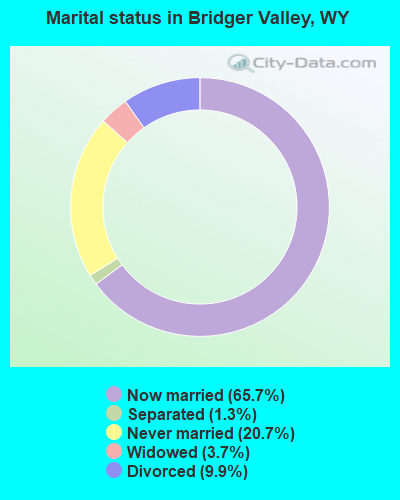
- Never married: 20.7%
- Now married: 65.7%
- Separated: 1.3%
- Widowed: 3.7%
- Divorced: 9.9%
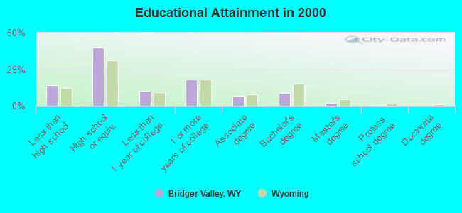
For population 25 years and over in Bridger Valley:
- High school or higher: 85.8%
- Bachelor's degree or higher: 11.3%
- Graduate or professional degree: 2.5%
- Unemployed: 5.6%
- Mean travel time to work (commute): 27.6 minutes
| Here: | 7.9 |
| Wyoming average: | 10.0 |
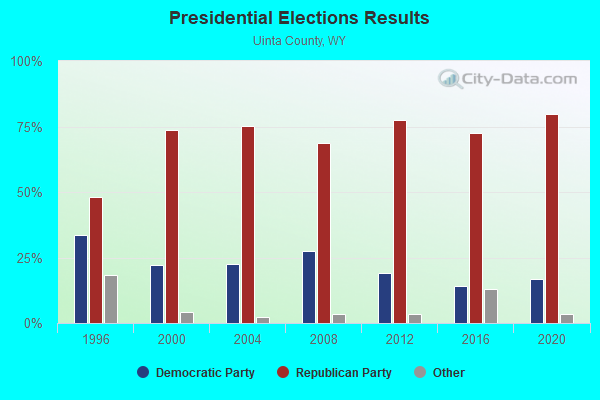
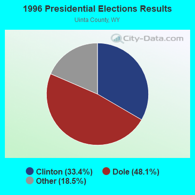
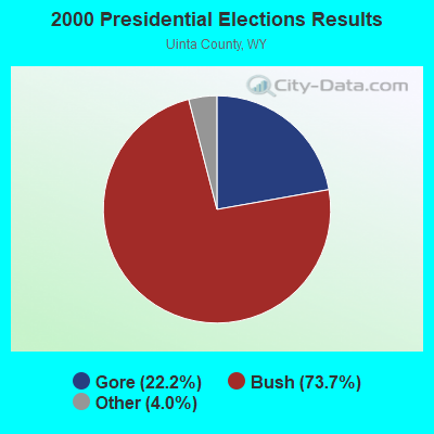
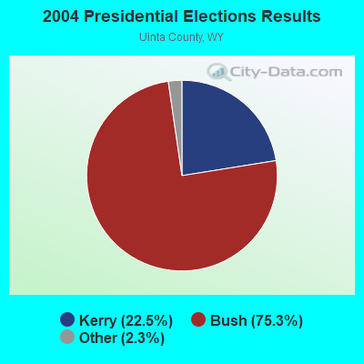
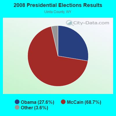
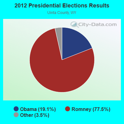
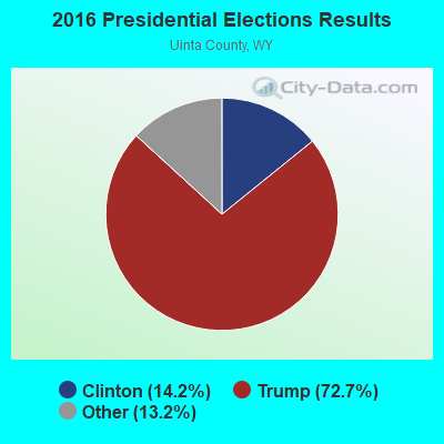
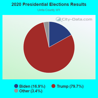
Graphs represent county-level data. Detailed 2008 Election Results
Religion statistics for Bridger Valley, WY (based on Uinta County data)
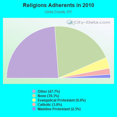
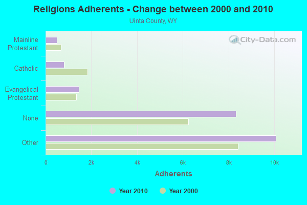
| Religion | Adherents | Congregations |
|---|---|---|
| Other | 10,066 | 23 |
| Evangelical Protestant | 1,450 | 16 |
| Catholic | 803 | 2 |
| Mainline Protestant | 496 | 6 |
| None | 8,303 | - |
Food Environment Statistics:
| Here: | 1.49 / 10,000 pop. |
| Wyoming: | 2.10 / 10,000 pop. |
| Uinta County: | 0.50 / 10,000 pop. |
| Wyoming: | 0.27 / 10,000 pop. |
| Uinta County: | 0.99 / 10,000 pop. |
| Wyoming: | 0.65 / 10,000 pop. |
| This county: | 7.44 / 10,000 pop. |
| State: | 5.36 / 10,000 pop. |
| Uinta County: | 8.43 / 10,000 pop. |
| Wyoming: | 10.08 / 10,000 pop. |
| Uinta County: | 6.4% |
| Wyoming: | 7.1% |
| Here: | 29.6% |
| Wyoming: | 24.4% |
Strongest AM radio stations in Bridger Valley:
- KALL (700 AM; 50 kW; NORTH SALT LAKE CITY, UT; Owner: CITICASTERS LICENSES, L.P.)
- KIQN (1010 AM; 50 kW; TOOELE, UT)
- KSL (1160 AM; 50 kW; SALT LAKE CITY, UT; Owner: BONNEVILLE HOLDING COMPANY)
- KMER (950 AM; 5 kW; KEMMERER, WY; Owner: CHAPARRAL BROADCASTING, INC.)
- KTKK (630 AM; 10 kW; SANDY, UT; Owner: UNITED BROADCASTING COMPANY)
- KSOS (800 AM; 10 kW; BRIGHAM CITY, UT; Owner: SIMMONS-SLC, LS, LLC)
- KBEE (860 AM; 10 kW; SALT LAKE CITY, UT; Owner: CITADEL BROADCASTING COMPANY)
- KNZZ (1100 AM; 50 kW; GRAND JUNCTION, CO; Owner: M B C GRAND BROADCASTING, INC.)
- KANN (1120 AM; 10 kW; ROY, UT; Owner: FAITH COMMUNICATIONS CORPORATION)
- KVEL (920 AM; 5 kW; VERNAL, UT; Owner: ASHLEY COMMUNICATIONS, INC.)
- KVNU (610 AM; 5 kW; LOGAN, UT; Owner: SUN VALLEY RADIO,INC.)
- KNRS (570 AM; 5 kW; SALT LAKE CITY, UT; Owner: CITICASTERS LICENSES, L.P.)
- KZNS (1280 AM; 10 kW; SALT LAKE CITY, UT; Owner: SIMMONS-SLC, LS, LLC)
Strongest FM radio stations in Bridger Valley:
- K224CI (92.7 FM; LYMAN, WY; Owner: WESTERN INSPIRATIONAL BROADCASTERS)
- KOTB (106.1 FM; EVANSTON, WY; Owner: ROCKY MOUNTAIN RADIO NETWORK, INC.)
- KNYN (99.1 FM; FORT BRIDGER, WY; Owner: M. KENT FRANDSEN)
- K209DC (89.7 FM; EVANSTON, WY; Owner: CALVARY CHAPEL OF TWIN FALLS, INC.)
- K240CP (95.9 FM; EVANSTON, WY; Owner: WESTERN INSPIRATIONAL BROADCASTERS, INC)
- KWKD (102.3 FM; RANDOLPH, UT; Owner: MILLCREEK BROADCASTING, L.L.C.)
- KCUA (92.5 FM; COALVILLE, UT; Owner: COMMUNITY WIRELESS OF PARK CITY, INC)
- KDWY (105.3 FM; DIAMONDVILLE, WY; Owner: JERROLD T. LUNDQUIST)
- KBZN-FM1 (97.9 FM; PARK CITY, UT; Owner: CAPITOL BROADCASTING INC.)
- K201AE (88.1 FM; COALVILLE, ETC., UT; Owner: COMMUNITY WIRELESS OF PARK CITY, INC)
- KZHT-FM1 (94.9 FM; PARK CITY, UT; Owner: CITICASTERS LICENSES, L.P.)
- KAOX (107.3 FM; KEMMERER, WY; Owner: JERROLD T. LUNDQUIST)
- K203BX (88.5 FM; LYMAN, WY; Owner: FAITH COMMUNICATIONS CORPORATION)
TV broadcast stations around Bridger Valley:
- K25EE (Channel 25; MOUNTAIN VIEW, ETC., UT; Owner: DAGGETT COUNTY TELEVISION DEPT.)
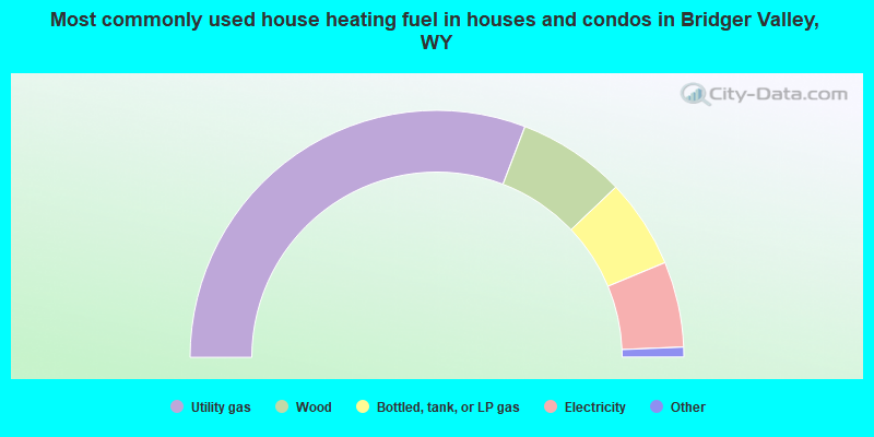
- 61.6%Utility gas
- 14.2%Wood
- 11.7%Bottled, tank, or LP gas
- 11.2%Electricity
- 0.7%Coal or coke
- 0.6%Other fuel
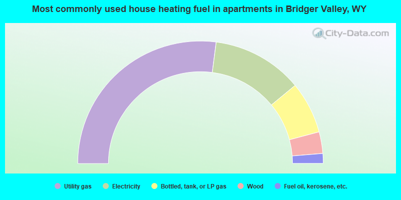
- 54.1%Utility gas
- 23.9%Electricity
- 13.7%Bottled, tank, or LP gas
- 5.7%Wood
- 2.6%Fuel oil, kerosene, etc.
Bridger Valley compared to Wyoming state average:
- Unemployed percentage below state average.
- Black race population percentage significantly below state average.
- Hispanic race population percentage significantly below state average.
- Median age significantly below state average.
- Foreign-born population percentage significantly below state average.
- Renting percentage below state average.
- Length of stay since moving in significantly above state average.
- Number of rooms per house significantly below state average.
- House age significantly below state average.
- Number of college students below state average.
- Percentage of population with a bachelor's degree or higher below state average.
Bridger Valley on our top lists:
- #1 on the list of "Top 101 cities with largest percentage of males in occupations: plant and system operators (population 5,000+)"
- #1 on the list of "Top 101 cities with largest percentage of females in occupations: extraction workers (population 5,000+)"
- #3 on the list of "Top 101 cities with largest percentage of males in occupations: supervisors of construction and extraction workers (population 5,000+)"
- #4 on the list of "Top 101 cities with largest percentage of females in industries: food and beverage stores (population 5,000+)"
- #4 on the list of "Top 101 cities with largest percentage of males in occupations: extraction workers (population 5,000+)"
- #5 on the list of "Top 101 cities with largest percentage of females in industries: gasoline stations (population 5,000+)"
- #7 on the list of "Top 101 cities with largest percentage of males in industries: gasoline stations (population 5,000+)"
- #7 on the list of "Top 101 cities with largest percentage of males in industries: chemicals (population 5,000+)"
- #11 on the list of "Top 101 cities with largest percentage of females in industries: broadcasting and telecommunications (population 5,000+)"
- #12 on the list of "Top 101 cities with largest percentage of females in occupations: communications equipment operators (population 5,000+)"
- #14 on the list of "Top 101 cities with largest percentage of females in occupations: other transportation workers (population 5,000+)"
- #16 on the list of "Top 101 cities with largest percentage of females in industries: repair and maintenance (population 5,000+)"
- #19 on the list of "Top 101 cities with largest percentage of males in industries: mining, quarrying, and oil and gas extraction (population 5,000+)"
- #33 on the list of "Top 101 cities with largest percentage of females in industries: personal and laundry services (population 5,000+)"
- #41 on the list of "Top 100 cities with largest land areas (pop. 5,000+)"
- #48 on the list of "Top 101 cities with largest percentage of females in industries: rail transportation (population 5,000+)"
- #54 on the list of "Top 100 low-educated but high-earning cities (pop. 5,000+)"
- #61 on the list of "Top 101 cities with largest percentage of females in industries: petroleum and coal products (population 5,000+)"
- #66 on the list of "Top 101 cities with the most cars per house, population 5,000+"
- #97 on the list of "Top 101 cities with largest percentage of males in industries: petroleum and coal products (population 5,000+)"
- #1 on the list of "Top 101 counties with the lowest Nitrogen Dioxide air pollution readings in 2012 (ppm)"
- #22 on the list of "Top 101 counties with the highest Ozone (1-hour) air pollution readings in 2012 (ppm)"
- #47 on the list of "Top 101 counties with the lowest Particulate Matter (PM10) Annual air pollution readings in 2012 (µg/m3)"