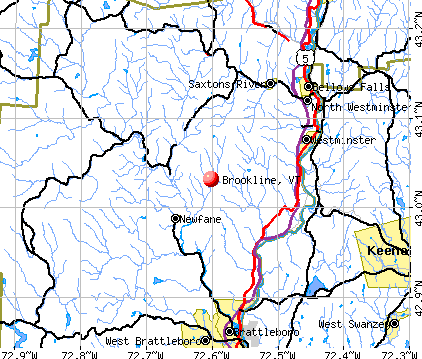
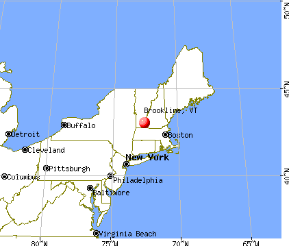
Brookline, Vermont
Submit your own pictures of this town and show them to the world
- OSM Map
- General Map
- Google Map
- MSN Map
Population change since 2000: +13.5%
 |
| Males: 276 | |
| Females: 254 |
| Median resident age: | 40.5 years |
| Vermont median age: | 45.8 years |
Zip codes: 05345.
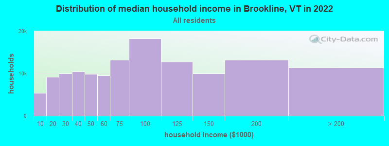
| Brookline: | $67,031 |
| VT: | $73,991 |
Estimated per capita income in 2022: $35,961 (it was $18,082 in 2000)
Brookline town income, earnings, and wages data
Estimated median house or condo value in 2022: $262,726 (it was $105,600 in 2000)
| Brookline: | $262,726 |
| VT: | $304,700 |
Mean prices in 2022: all housing units: $298,935; detached houses: $317,292; townhouses or other attached units: $299,018; in 2-unit structures: $292,940; in 3-to-4-unit structures: $427,770; in 5-or-more-unit structures: $214,034; mobile homes: $65,502
Detailed information about poverty and poor residents in Brookline, VT


- 51997.9%White alone
- 40.8%Asian alone
- 40.8%Two or more races
- 20.4%American Indian alone
- 10.2%Hispanic

Races in Brookline detailed stats: ancestries, foreign born residents, place of birth
According to our research of Vermont and other state lists, there was 1 registered sex offender living in Brookline, Vermont as of April 19, 2024.
The ratio of all residents to sex offenders in Brookline is 530 to 1.
The ratio of registered sex offenders to all residents in this city is near the state average.
 Recent articles from our blog. Our writers, many of them Ph.D. graduates or candidates, create easy-to-read articles on a wide variety of topics.

 | Another 'Where Should I Live in Vermont' Post (11 replies) |
| Southern Vermont Campgrounds near Brattlboro? (11 replies) |
| Best Southern VT Town for Raising Kids (7 replies) |
| We're moving to burlington? Vermont? (30 replies) |
| Southern moving to NE, needing guidance (18 replies) |
| The state of our education system (13 replies) |
Latest news from Brookline, VT collected exclusively by city-data.com from local newspapers, TV, and radio stations
Ancestries: English (20.6%), German (15.6%), French (12.6%), Irish (12.6%), Italian (7.5%), French Canadian (7.3%).
Current Local Time: EST time zone
Elevation: 612 feet
Land area: 12.9 square miles.
Population density: 41 people per square mile (very low).
4 residents are foreign born
| This town: | 0.9% |
| Vermont: | 3.8% |
| Brookline town: | 1.8% ($1,947) |
| Vermont: | 2.0% ($2,196) |
Nearest city with pop. 50,000+: Manchester, NH  (58.4 miles , pop. 107,006).
Nearest city with pop. 200,000+: Boston, MA (91.1 miles , pop. 589,141).
Nearest city with pop. 1,000,000+: Bronx, NY (164.1 miles , pop. 1,332,650).
Nearest cities:
), ), )Latitude: 43.02 N, Longitude: 72.61 W
Area code commonly used in this area: 802

| Here: | 1.9% |
| Vermont: | 2.0% |
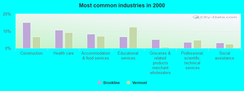
- Construction (15.0%)
- Health care (10.7%)
- Accommodation & food services (8.3%)
- Educational services (6.7%)
- Groceries & related products merchant wholesalers (5.1%)
- Professional, scientific, technical services (3.6%)
- Social assistance (3.2%)
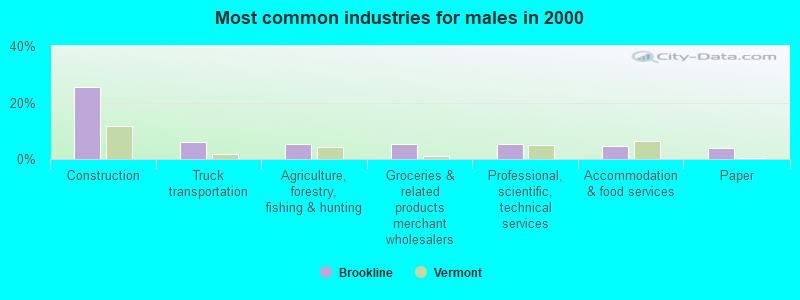
- Construction (25.4%)
- Truck transportation (6.2%)
- Agriculture, forestry, fishing & hunting (5.4%)
- Groceries & related products merchant wholesalers (5.4%)
- Professional, scientific, technical services (5.4%)
- Accommodation & food services (4.6%)
- Paper (3.8%)
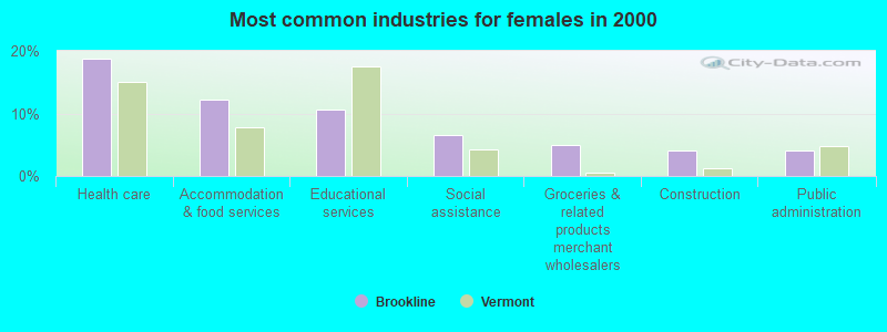
- Health care (18.7%)
- Accommodation & food services (12.2%)
- Educational services (10.6%)
- Social assistance (6.5%)
- Groceries & related products merchant wholesalers (4.9%)
- Construction (4.1%)
- Public administration (4.1%)
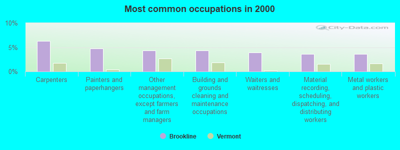
- Carpenters (6.3%)
- Painters and paperhangers (4.7%)
- Other management occupations, except farmers and farm managers (4.3%)
- Building and grounds cleaning and maintenance occupations (4.3%)
- Waiters and waitresses (4.0%)
- Material recording, scheduling, dispatching, and distributing workers (3.6%)
- Metal workers and plastic workers (3.6%)
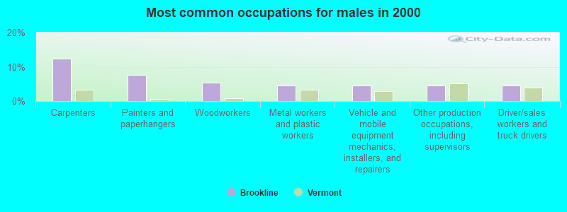
- Carpenters (12.3%)
- Painters and paperhangers (7.7%)
- Woodworkers (5.4%)
- Metal workers and plastic workers (4.6%)
- Vehicle and mobile equipment mechanics, installers, and repairers (4.6%)
- Other production occupations, including supervisors (4.6%)
- Driver/sales workers and truck drivers (4.6%)
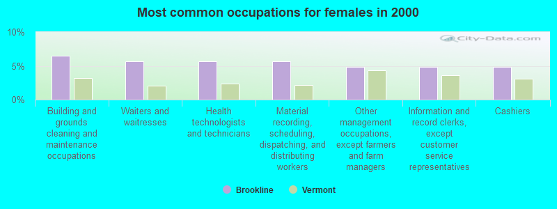
- Building and grounds cleaning and maintenance occupations (6.5%)
- Waiters and waitresses (5.7%)
- Health technologists and technicians (5.7%)
- Material recording, scheduling, dispatching, and distributing workers (5.7%)
- Other management occupations, except farmers and farm managers (4.9%)
- Information and record clerks, except customer service representatives (4.9%)
- Cashiers (4.9%)
Average climate in Brookline, Vermont
Based on data reported by over 4,000 weather stations


(lower is better)
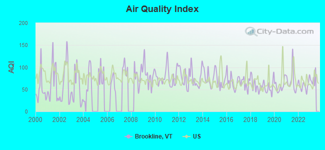
Air Quality Index (AQI) level in 2022 was 59.0. This is better than average.
| City: | 59.0 |
| U.S.: | 72.6 |
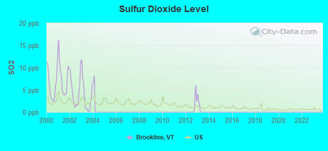
Sulfur Dioxide (SO2) [ppb] level in 2003 was 3.66. This is significantly worse than average. Closest monitor was 16.2 miles away from the city center.
| City: | 3.66 |
| U.S.: | 1.51 |
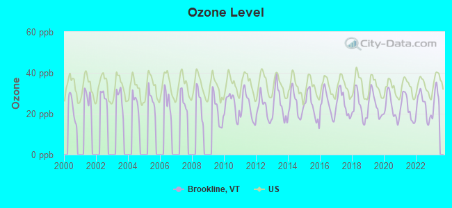
Ozone [ppb] level in 2022 was 23.7. This is significantly better than average. Closest monitor was 11.3 miles away from the city center.
| City: | 23.7 |
| U.S.: | 33.3 |

Particulate Matter (PM2.5) [µg/m3] level in 2022 was 5.97. This is better than average. Closest monitor was 18.0 miles away from the city center.
| City: | 5.97 |
| U.S.: | 8.11 |
Tornado activity:
Brookline-area historical tornado activity is significantly above Vermont state average. It is 34% smaller than the overall U.S. average.
On 8/20/1968, a category F3 (max. wind speeds 158-206 mph) tornado 11.2 miles away from the Brookline town center injured one person and caused between $5000 and $50,000 in damages.
On 6/9/1953, a category F4 (max. wind speeds 207-260 mph) tornado 44.2 miles away from the town center killed 90 people and injured 1228 people and caused between $50,000,000 and $500,000,000 in damages.
Earthquake activity:
Brookline-area historical earthquake activity is significantly above Vermont state average. It is 69% smaller than the overall U.S. average.On 10/7/1983 at 10:18:46, a magnitude 5.3 (5.1 MB, 5.3 LG, 5.1 ML, Class: Moderate, Intensity: VI - VII) earthquake occurred 108.3 miles away from the city center
On 4/20/2002 at 10:50:47, a magnitude 5.3 (5.3 ML, Depth: 3.0 mi) earthquake occurred 116.5 miles away from Brookline center
On 4/20/2002 at 10:50:47, a magnitude 5.2 (5.2 MB, 4.2 MS, 5.2 MW, 5.0 MW) earthquake occurred 115.5 miles away from Brookline center
On 1/19/1982 at 00:14:42, a magnitude 4.7 (4.5 MB, 4.7 MD, 4.5 LG, Class: Light, Intensity: IV - V) earthquake occurred 60.4 miles away from the city center
On 10/16/2012 at 23:12:25, a magnitude 4.7 (4.7 ML, Depth: 10.0 mi) earthquake occurred 105.8 miles away from the city center
On 6/17/1991 at 08:53:16, a magnitude 4.1 (4.0 MB, 4.0 LG, Depth: 3.1 mi) earthquake occurred 108.6 miles away from Brookline center
Magnitude types: regional Lg-wave magnitude (LG), body-wave magnitude (MB), duration magnitude (MD), local magnitude (ML), surface-wave magnitude (MS), moment magnitude (MW)
Natural disasters:
The number of natural disasters in Windham County (16) is near the US average (15).Major Disasters (Presidential) Declared: 13
Emergencies Declared: 2
Causes of natural disasters: Floods: 11, Storms: 10, Tropical Storms: 2, Hurricane: 1, Landslide: 1, Snowstorm: 1, Wind: 1, Winter Storm: 1 (Note: some incidents may be assigned to more than one category).

Hospitals and medical centers near Brookline:
- CHESHIRE COUNTY HOME (Nursing Home, about 8 miles away; WESTMORELAND, NH)
- MCGIRR NURSING HOME (Nursing Home, about 11 miles away; BELLOWS FALLS, VT)
- LINDEN LODGE NURSING HOME (Nursing Home, about 12 miles away; BRATTLEBORO, VT)
- SOUTHERN VERMONT HOME HEALTH (Home Health Center, about 13 miles away; BRATTLEBORO, VT)
- THOMPSON HOUSE NURSING HOME (Nursing Home, about 13 miles away; BRATTLEBORO, VT)
- BRATTLEBORO MEMORIAL HOSPITAL Acute Care Hospitals (about 13 miles away; BRATTLEBORO, VT)
- PINE HEIGHTS AT BRATTLEBORO CENTER FOR NURSING AND R (Nursing Home, about 13 miles away; BRATTLEBORO, VT)
Heliports located in Brookline:
Amtrak stations near Brookline:
- 12 miles: BELLOWS FALLS (DEPOT ST.) . Services: enclosed waiting area, public restrooms, public payphones, free short-term parking, free long-term parking, call for taxi service.
- 14 miles: BRATTLEBORO (VERNON RD.) . Services: enclosed waiting area, public restrooms, call for car rental service, call for taxi service.
Operable nuclear power plant near Brookline:
- 19 miles: Vermont Yankee in Vernon, VT.
Colleges/universities with over 2000 students nearest to Brookline:
- Keene State College (about 18 miles; Keene, NH; Full-time enrollment: 5,098)
- Franklin Pierce University (about 33 miles; Rindge, NH; FT enrollment: 2,139)
- Williams College (about 38 miles; Williamstown, MA; FT enrollment: 2,141)
- Mount Wachusett Community College (about 44 miles; Gardner, MA; FT enrollment: 3,143)
- University of Massachusetts-Amherst (about 45 miles; Amherst, MA; FT enrollment: 26,583)
- Smith College (about 49 miles; Northampton, MA; FT enrollment: 3,549)
- Dartmouth College (about 50 miles; Hanover, NH; FT enrollment: 6,030)
Points of interest:
Cemeteries: Ezequelle Cemetery (1), Cole-Brown Cemetery (2), Riverside Cemetery (3). Display/hide their locations on the map
Drinking water stations with addresses in Brookline and their reported violations in the past:
HARMONYVILLE STORE (Address: 27 SUNNY LANE , Population served: 50, Groundwater):Past health violations:Past monitoring violations:
- MCL, Monthly (TCR) - In JUN-2011, Contaminant: Coliform. Follow-up actions: St Tech Assistance Visit (JUN-24-2011), St Formal NOV issued (JUN-24-2011), St Public Notif requested (JUN-24-2011), St Boil Water Order (JUN-24-2011), St Compliance achieved (FEB-01-2012)
- 2 routine major monitoring violations
| This town: | 2.6 people |
| Vermont: | 2.3 people |
| This town: | 71.4% |
| Whole state: | 62.5% |
| This town: | 9.7% |
| Whole state: | 9.2% |
Likely homosexual households (counted as self-reported same-sex unmarried-partner households)
- Lesbian couples: 0.0% of all households
- Gay men: 1.0% of all households
| This town: | 8.5% |
| Whole state: | 9.4% |
| This town: | 2.7% |
| Whole state: | 3.6% |
For population 15 years and over in Brookline:
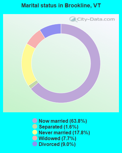
- Never married: 17.8%
- Now married: 63.8%
- Separated: 1.6%
- Widowed: 7.7%
- Divorced: 9.0%
For population 25 years and over in Brookline:
- High school or higher: 88.5%
- Bachelor's degree or higher: 23.0%
- Graduate or professional degree: 10.6%
- Mean travel time to work (commute): 25.3 minutes
| Here: | 10.5 |
| Vermont average: | 11.7 |
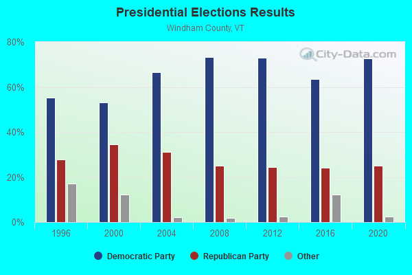
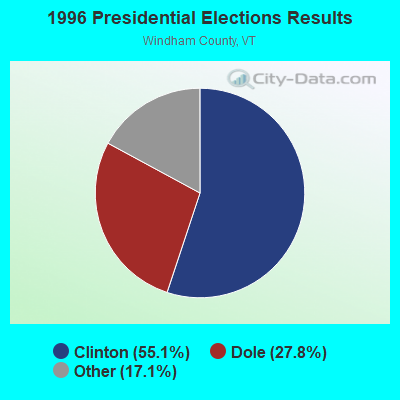
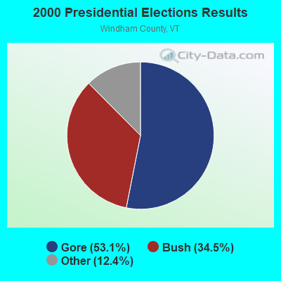
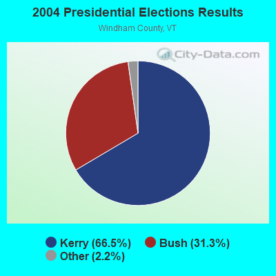
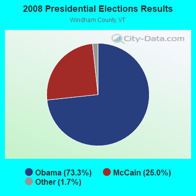

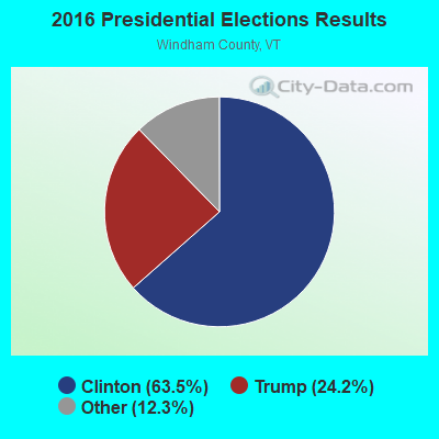
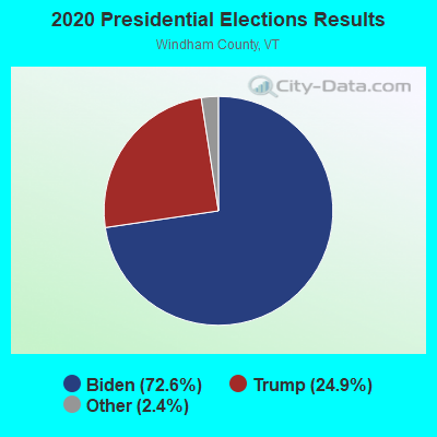
Graphs represent county-level data. Detailed 2008 Election Results
Religion statistics for Brookline, VT (based on Windham County data)
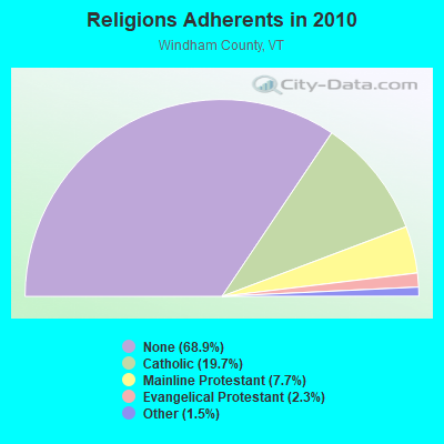
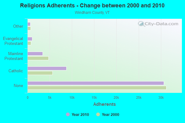
| Religion | Adherents | Congregations |
|---|---|---|
| Catholic | 8,753 | 8 |
| Mainline Protestant | 3,412 | 38 |
| Evangelical Protestant | 1,026 | 13 |
| Other | 647 | 12 |
| None | 30,675 | - |
Food Environment Statistics:
| Windham County: | 4.14 / 10,000 pop. |
| Vermont: | 3.84 / 10,000 pop. |
| Windham County: | 1.38 / 10,000 pop. |
| Vermont: | 1.95 / 10,000 pop. |
| Here: | 7.37 / 10,000 pop. |
| Vermont: | 6.40 / 10,000 pop. |
| Windham County: | 18.87 / 10,000 pop. |
| Vermont: | 11.52 / 10,000 pop. |
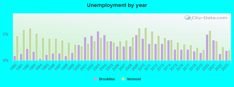
| Here: | 6.7% |
| Vermont: | 6.8% |
| This county: | 22.6% |
| State: | 22.3% |
| This county: | 12.5% |
| State: | 13.3% |
Strongest AM radio stations in Brookline:
- WNNZ (640 AM; 50 kW; WESTFIELD, MA; Owner: CLEAR CHANNEL BROADCASTING LICENSES, INC.)
- WKBK (1290 AM; 5 kW; KEENE, NH; Owner: SAGA COMMUNICATIONS OF NEW ENGLAND, LLC)
- WCRN (830 AM; 50 kW; WORCESTER, MA; Owner: CARTER BROADCASTING CORPORATION)
- WGY (810 AM; 50 kW; SCHENECTADY, NY; Owner: CLEAR CHANNEL BROADCASTING LICENSES, INC.)
- WRKO (680 AM; 50 kW; BOSTON, MA; Owner: ENTERCOM BOSTON LICENSE, LLC)
- WNBX (1480 AM; 5 kW; SPRINGFIELD, VT)
- WNTK (1020 AM; 10 kW; NEWPORT, NH; Owner: KOOR COMMUNICATIONS, INC.)
- WVNE (760 AM; daytime; 25 kW; LEICESTER, MA; Owner: BLOUNT MASSCOM, INC.)
- WIZZ (1520 AM; daytime; 10 kW; GREENFIELD, MA; Owner: P. & M. RADIO, LLC)
- WEEI (850 AM; 50 kW; BOSTON, MA; Owner: ENTERCOM BOSTON LICENSE, LLC)
- WPTR (1540 AM; 50 kW; ALBANY, NY; Owner: KIMTRON, INC.)
- WKOX (1200 AM; 50 kW; FRAMINGHAM, MA; Owner: CAPSTAR TX LIMITED PARTNERSHIP)
- WALE (990 AM; 50 kW; GREENVILLE, RI; Owner: NORTH AMERICAN BROADCASTING CO., INC.)
Strongest FM radio stations in Brookline:
- WCMK (91.9 FM; PUTNEY, VT; Owner: CHRISTIAN MINISTRIES INC)
- WKNE (103.7 FM; KEENE, NH; Owner: SAGA COMMUNICATIONS OF NEW ENGLAND, LLC)
- WVAY (100.7 FM; WILMINGTON, VT; Owner: GREAT NORTHERN RADIO, L.L.C.)
- WEVN (90.7 FM; KEENE, NH; Owner: NEW HAMPSHIRE PUBLIC RADIO, INC.)
- WCFR-FM (96.3 FM; WALPOLE, NH; Owner: GREAT NORTHERN RADIO, LLC)
- WKVT-FM (92.7 FM; BRATTLEBORO, VT; Owner: SAGA COMMUNICATIONS OF NEW ENGLAND, LLC)
- WEQX (102.7 FM; MANCHESTER, VT; Owner: NORTHSHIRE COMMUNICATIONS, INC.)
- WJAN (95.1 FM; SUNDERLAND, VT; Owner: 6 JOHNSON ROAD LICENSES, INC.)
- WRSY (101.5 FM; MARLBORO, VT; Owner: GREAT NORTHERN RADIO, L.L.C.)
- WHDQ (106.1 FM; CLAREMONT, NH; Owner: GREAT NORTHERN RADIO, L.L.C.)
- WVPR (89.5 FM; WINDSOR, VT; Owner: VERMONT PUBLIC RADIO)
- WJJR (98.1 FM; RUTLAND, VT; Owner: 6 JOHNSON ROAD LICENSES, INC.)
- WZRT (97.1 FM; RUTLAND, VT; Owner: CAPSTAR TX LIMITED PARTNERSHIP)
- WEBK (105.3 FM; KILLINGTON, VT; Owner: 6 JOHNSON ROAD LICENSES, INC.)
- WAMC-FM (90.3 FM; ALBANY, NY; Owner: WAMC)
- WGLV (91.7 FM; WOODSTOCK, VT; Owner: CHRISTIAN MINISTRIES INC)
- WHDQ-FM1 (106.1 FM; RUTLAND, VT; Owner: GREAT NORTHERN RADIO, L.L.C.)
- W293AB (106.5 FM; KEENE, NH; Owner: GREAT NORTHERN RADIO, L.L.C.)
- WOQL (98.7 FM; WINCHESTER, NH; Owner: SAGA COMMUNICATIONS OF NEW HAMPSHIRE, LLC)
- WYRY (104.9 FM; HINSDALE, NH; Owner: TRI-VALLEY BROADCASTING CORPORATION)
TV broadcast stations around Brookline:
- WEKW-TV (Channel 52; KEENE, NH; Owner: UNIVERSITY OF NEW HAMPSHIRE)
- National Bridge Inventory (NBI) Statistics
- 2Number of bridges
- 16ft / 4.6mTotal length
- $607,000Total costs
- 850Total average daily traffic
- 25Total average daily truck traffic
- 893Total future (year 2029) average daily traffic
FCC Registered Amateur Radio Licenses:
1- Call Sign: N1SAY, Licensee ID: L00726309, Grant Date: 04/22/2014, Expiration Date: 06/14/2024, Registrant: Jason R Butterfield, 301 Grassy Brook Road, Brookline, VT 05345
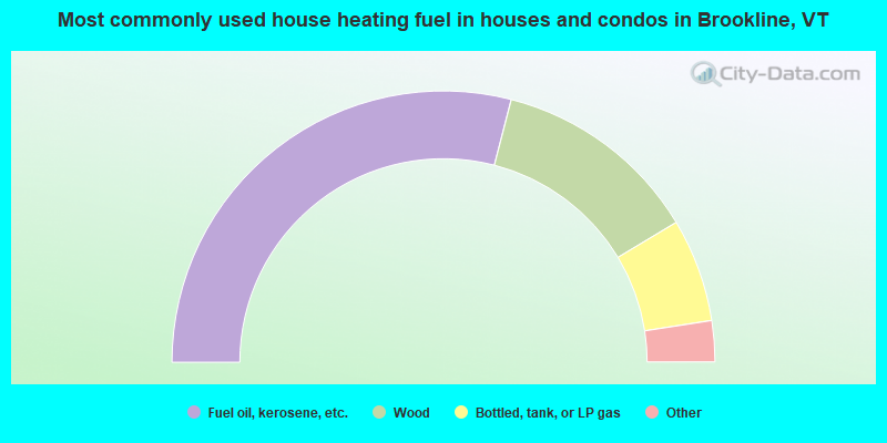
- 58.0%Fuel oil, kerosene, etc.
- 24.7%Wood
- 12.3%Bottled, tank, or LP gas
- 2.5%Coal or coke
- 2.5%Other fuel
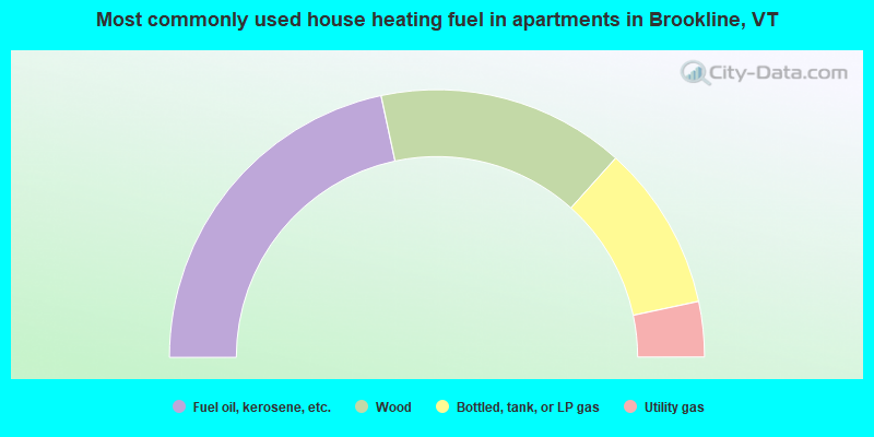
- 43.3%Fuel oil, kerosene, etc.
- 30.0%Wood
- 20.0%Bottled, tank, or LP gas
- 6.7%Utility gas
Brookline compared to Vermont state average:
- Unemployed percentage significantly below state average.
- Black race population percentage significantly below state average.
- Hispanic race population percentage significantly below state average.
- Median age below state average.
- Foreign-born population percentage significantly below state average.
- Renting percentage below state average.
- Length of stay since moving in significantly above state average.
- Number of rooms per house significantly below state average.
- House age significantly below state average.
- Number of college students below state average.