Buckland, Massachusetts

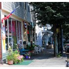
Buckland: View of the Bridge of Flowers from Buckland, MA
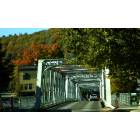
Buckland: Buckland-Shelburne Bridge
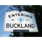
Buckland: Entering Buckland, MA
Buckland: Buckland, MA
- add
your
Submit your own pictures of this town and show them to the world
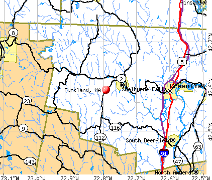
- OSM Map
- General Map
- Google Map
- MSN Map
Population change since 2000: -4.5%
 |
| Males: 910 | |
| Females: 992 |
| Median resident age: | 46.7 years |
| Massachusetts median age: | 39.2 years |
Zip codes: 01370.
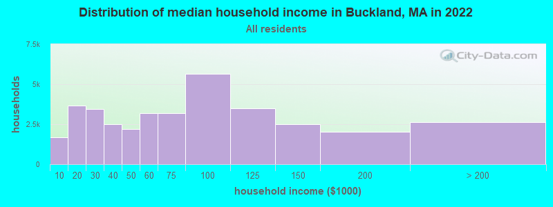
| Buckland: | $79,041 |
| MA: | $94,488 |
Estimated per capita income in 2022: $36,499 (it was $20,033 in 2000)
Buckland town income, earnings, and wages data
Estimated median house or condo value in 2022: $300,209 (it was $120,800 in 2000)
| Buckland: | $300,209 |
| MA: | $534,700 |
Mean prices in 2022: all housing units: $313,377; detached houses: $324,224; townhouses or other attached units: $284,225; in 2-unit structures: $287,978; in 3-to-4-unit structures: $183,938; in 5-or-more-unit structures: $249,762; mobile homes: $62,200
Detailed information about poverty and poor residents in Buckland, MA


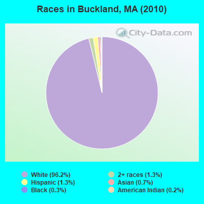
- 1,82996.2%White alone
- 251.3%Two or more races
- 251.3%Hispanic
- 130.7%Asian alone
- 50.3%Black alone
- 40.2%American Indian alone
- 10.05%Other race alone
Races in Buckland detailed stats: ancestries, foreign born residents, place of birth
According to our research of Massachusetts and other state lists, there was 1 registered sex offender living in Buckland, Massachusetts as of April 25, 2024.
The ratio of all residents to sex offenders in Buckland is 1,902 to 1.
The ratio of registered sex offenders to all residents in this city is lower than the state average.
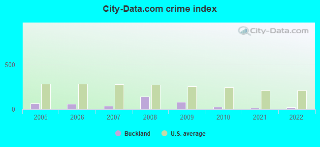
Type |
2009 |
2010 |
2021 |
2022 |
|---|---|---|---|---|
| Murders (per 100,000) | 0 (0.0) | 0 (0.0) | 0 (0.0) | 0 (0.0) |
| Rapes (per 100,000) | 0 (0.0) | 0 (0.0) | 0 (0.0) | 0 (0.0) |
| Robberies (per 100,000) | 0 (0.0) | 0 (0.0) | 0 (0.0) | 0 (0.0) |
| Assaults (per 100,000) | 1 (49.7) | 0 (0.0) | 1 (54.1) | 2 (110.2) |
| Burglaries (per 100,000) | 2 (99.5) | 2 (105.2) | 0 (0.0) | 0 (0.0) |
| Thefts (per 100,000) | 30 (1,492) | 10 (525.8) | 3 (162.4) | 0 (0.0) |
| Auto thefts (per 100,000) | 1 (49.7) | 0 (0.0) | 0 (0.0) | 0 (0.0) |
| Arson (per 100,000) | 0 (0.0) | 0 (0.0) | 0 (0.0) | 0 (0.0) |
| City-Data.com crime index | 80.6 | 28.4 | 17.3 | 22.0 |
The City-Data.com crime index weighs serious crimes and violent crimes more heavily. Higher means more crime, U.S. average is 246.1. It adjusts for the number of visitors and daily workers commuting into cities.
Crime rate in Buckland detailed stats: murders, rapes, robberies, assaults, burglaries, thefts, arson
Full-time law enforcement employees in 2021, including police officers: 1 (1 officers - 1 male; 0 female).
| Officers per 1,000 residents here: | 0.54 |
| Massachusetts average: | 2.53 |
 Recent articles from our blog. Our writers, many of them Ph.D. graduates or candidates, create easy-to-read articles on a wide variety of topics.

 | MA 2022 Question 1 (258 replies) |
| Is it possible to escape hunters, ATVs and noise in a rural area? (278 replies) |
| Opinions on Northfield, Shelburne Falls (14 replies) |
| Which Franklin county town for young family? (12 replies) |
| How Much Massachusetts Households Make Per Year: Census Data (37 replies) |
| Touring Western Mass - Need to be convinced to live there (16 replies) |
Latest news from Buckland, MA collected exclusively by city-data.com from local newspapers, TV, and radio stations
Ancestries: English (29.6%), Irish (17.2%), French (12.3%), German (11.2%), Italian (8.0%), Polish (5.8%).
Current Local Time: EST time zone
Incorporated in 1779
Elevation: 690 feet
Land area: 19.6 square miles.
Population density: 97 people per square mile (very low).
34 residents are foreign born
| This town: | 1.7% |
| Massachusetts: | 12.2% |
| Buckland town: | 1.5% ($1,830) |
| Massachusetts: | 1.3% ($2,336) |
Nearest city with pop. 50,000+: Chicopee, MA  (31.1 miles , pop. 54,653).
Nearest city with pop. 200,000+: Boston, MA (88.0 miles , pop. 589,141).
Nearest city with pop. 1,000,000+: Bronx, NY (133.8 miles , pop. 1,332,650).
Nearest cities:
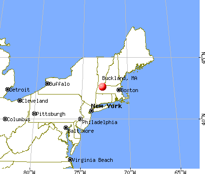
), ), )Latitude: 42.60 N, Longitude: 72.77 W
Area code commonly used in this area: 413

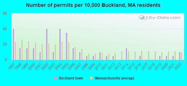
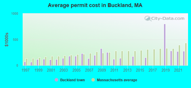
Single-family new house construction building permits:
- 2022: 2 buildings, average cost: $275,000
- 2021: 1 building, cost: $270,400
- 2020: 1 building, cost: $280,000
- 2019: 1 building, cost: $805,000
- 2016: 1 building, cost: $150,000
- 2014: 3 buildings, average cost: $173,300
- 2012: 1 building, cost: $140,000
- 2011: 1 building, cost: $127,200
- 2010: 2 buildings, average cost: $256,600
- 2009: 1 building, cost: $327,400
- 2008: 1 building, cost: $197,500
- 2007: 2 buildings, average cost: $132,900
- 2006: 3 buildings, average cost: $233,600
- 2005: 7 buildings, average cost: $181,100
- 2004: 8 buildings, average cost: $179,200
- 2003: 2 buildings, average cost: $138,700
- 2002: 8 buildings, average cost: $121,200
- 2001: 2 buildings, average cost: $110,700
- 2000: 3 buildings, average cost: $126,700
- 1999: 3 buildings, average cost: $115,900
- 1998: 3 buildings, average cost: $66,300
- 1997: 8 buildings, average cost: $72,600
| Here: | 2.2% |
| Massachusetts: | 3.5% |
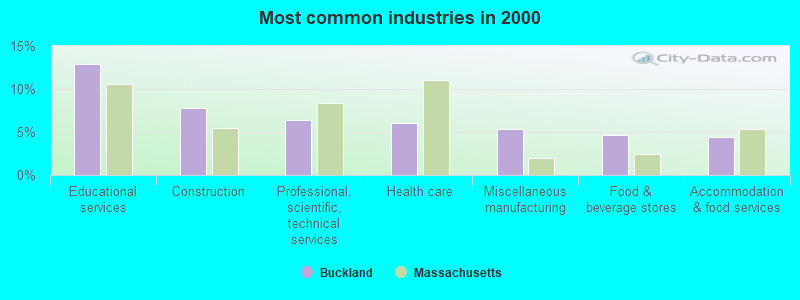
- Educational services (12.9%)
- Construction (7.8%)
- Professional, scientific, technical services (6.4%)
- Health care (6.0%)
- Miscellaneous manufacturing (5.3%)
- Food & beverage stores (4.7%)
- Accommodation & food services (4.4%)
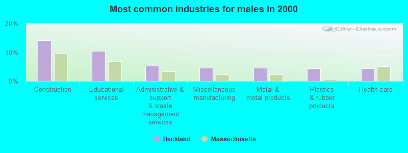
- Construction (14.1%)
- Educational services (10.4%)
- Administrative & support & waste management services (5.3%)
- Miscellaneous manufacturing (4.6%)
- Metal & metal products (4.6%)
- Plastics & rubber products (4.4%)
- Health care (4.4%)
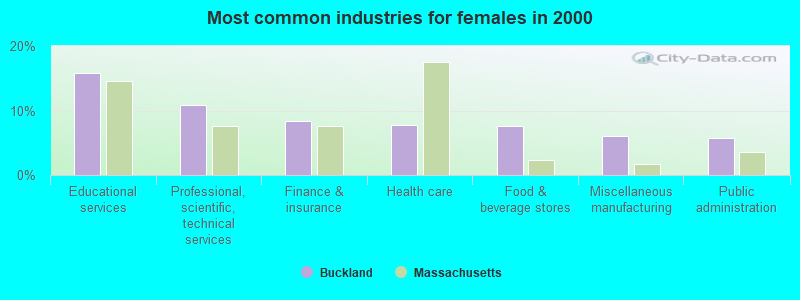
- Educational services (15.8%)
- Professional, scientific, technical services (10.9%)
- Finance & insurance (8.4%)
- Health care (7.8%)
- Food & beverage stores (7.6%)
- Miscellaneous manufacturing (6.1%)
- Public administration (5.7%)
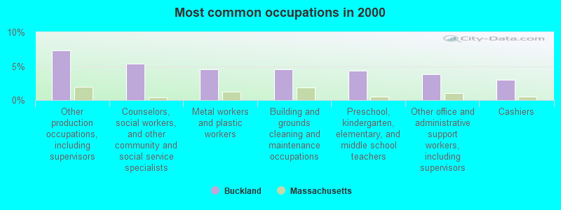
- Other production occupations, including supervisors (7.4%)
- Counselors, social workers, and other community and social service specialists (5.4%)
- Metal workers and plastic workers (4.6%)
- Building and grounds cleaning and maintenance occupations (4.5%)
- Preschool, kindergarten, elementary, and middle school teachers (4.3%)
- Other office and administrative support workers, including supervisors (3.9%)
- Cashiers (3.0%)
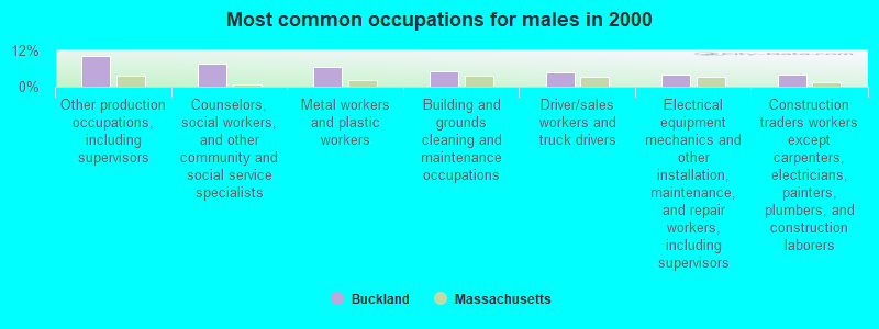
- Other production occupations, including supervisors (10.4%)
- Counselors, social workers, and other community and social service specialists (7.6%)
- Metal workers and plastic workers (6.6%)
- Building and grounds cleaning and maintenance occupations (4.9%)
- Driver/sales workers and truck drivers (4.8%)
- Electrical equipment mechanics and other installation, maintenance, and repair workers, including supervisors (4.1%)
- Construction traders workers except carpenters, electricians, painters, plumbers, and construction laborers (3.9%)
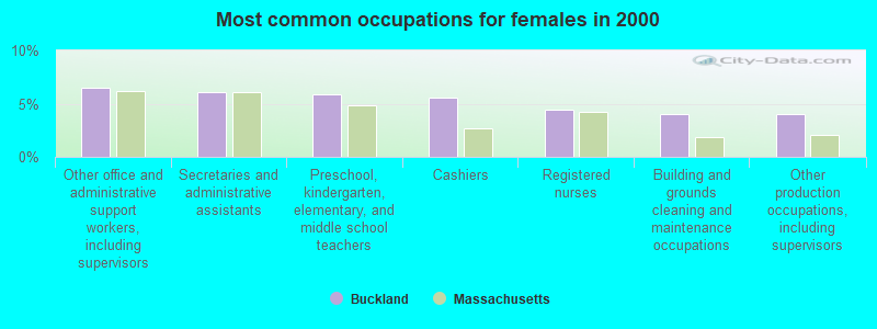
- Other office and administrative support workers, including supervisors (6.5%)
- Secretaries and administrative assistants (6.1%)
- Preschool, kindergarten, elementary, and middle school teachers (5.9%)
- Cashiers (5.5%)
- Registered nurses (4.4%)
- Building and grounds cleaning and maintenance occupations (4.0%)
- Other production occupations, including supervisors (4.0%)
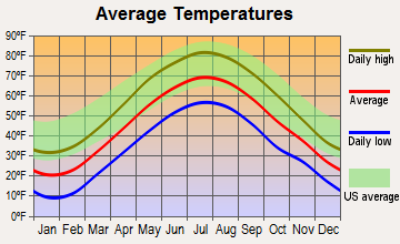
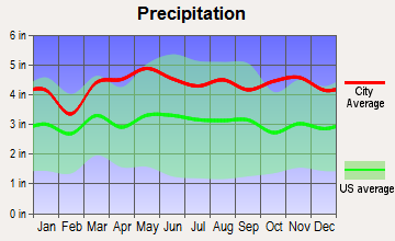
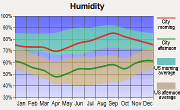
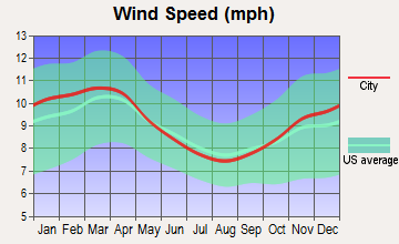
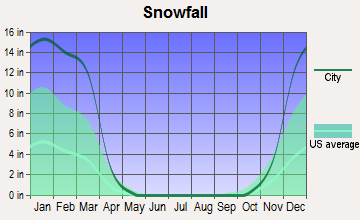
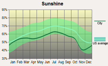
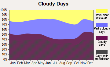
Average climate in Buckland, Massachusetts
Based on data reported by over 4,000 weather stations
(lower is better)
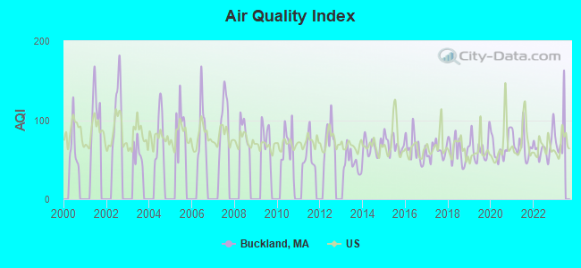
Air Quality Index (AQI) level in 2022 was 65.9. This is about average.
| City: | 65.9 |
| U.S.: | 72.6 |
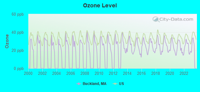
Ozone [ppb] level in 2022 was 23.8. This is better than average. Closest monitor was 9.0 miles away from the city center.
| City: | 23.8 |
| U.S.: | 33.3 |
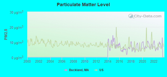
Particulate Matter (PM2.5) [µg/m3] level in 2022 was 7.03. This is about average. Closest monitor was 9.0 miles away from the city center.
| City: | 7.03 |
| U.S.: | 8.11 |
Tornado activity:
Buckland-area historical tornado activity is slightly above Massachusetts state average. It is 16% smaller than the overall U.S. average.
On 6/9/1953, a category F4 (max. wind speeds 207-260 mph) tornado 32.0 miles away from the Buckland town center killed 90 people and injured 1228 people and caused between $50,000,000 and $500,000,000 in damages.
On 8/28/1973, a category F4 tornado 35.2 miles away from the town center killed 4 people and injured 36 people and caused between $5,000,000 and $50,000,000 in damages.
Earthquake activity:
Buckland-area historical earthquake activity is significantly above Massachusetts state average. It is 69% smaller than the overall U.S. average.On 10/7/1983 at 10:18:46, a magnitude 5.3 (5.1 MB, 5.3 LG, 5.1 ML, Class: Moderate, Intensity: VI - VII) earthquake occurred 122.6 miles away from Buckland center
On 4/20/2002 at 10:50:47, a magnitude 5.3 (5.3 ML, Depth: 3.0 mi) earthquake occurred 140.2 miles away from Buckland center
On 4/20/2002 at 10:50:47, a magnitude 5.2 (5.2 MB, 4.2 MS, 5.2 MW, 5.0 MW) earthquake occurred 139.0 miles away from Buckland center
On 1/19/1982 at 00:14:42, a magnitude 4.7 (4.5 MB, 4.7 MD, 4.5 LG, Class: Light, Intensity: IV - V) earthquake occurred 86.0 miles away from the city center
On 10/16/2012 at 23:12:25, a magnitude 4.7 (4.7 ML, Depth: 10.0 mi) earthquake occurred 127.3 miles away from the city center
On 6/17/1991 at 08:53:16, a magnitude 4.1 (4.0 MB, 4.0 LG, Depth: 3.1 mi) earthquake occurred 97.0 miles away from the city center
Magnitude types: regional Lg-wave magnitude (LG), body-wave magnitude (MB), duration magnitude (MD), local magnitude (ML), surface-wave magnitude (MS), moment magnitude (MW)
Natural disasters:
The number of natural disasters in Franklin County (20) is greater than the US average (15).Major Disasters (Presidential) Declared: 9
Emergencies Declared: 10
Causes of natural disasters: Floods: 5, Storms: 5, Hurricanes: 4, Snowstorms: 4, Winter Storms: 3, Blizzards: 2, Snows: 2, Snowfall: 1, Tropical Storm: 1, Wind: 1, Other: 1 (Note: some incidents may be assigned to more than one category).
Hospitals and medical centers near Buckland:
- ANCHORAGE NURSING HOME (Nursing Home, about 5 miles away; SHELBURNE, MA)
- CHARLENE MANOR EXTENDED CARE FACILITY (Nursing Home, about 8 miles away; GREENFIELD, MA)
- BUCKLEY-GREENFIELD HEALTHCARE CENTER (Nursing Home, about 9 miles away; GREENFIELD, MA)
- HOSPICE OF FRANKLIN COUNTY, INC (Hospital, about 9 miles away; GREENFIELD, MA)
- FRANKLIN CENTER (Nursing Home, about 9 miles away; GREENFIELD, MA)
- GENTIVA HEALTH SERVICES (Home Health Center, about 9 miles away; GREENFIELD, MA)
- HOME CARE PRN INC (Home Health Center, about 9 miles away; GREENFIELD, MA)
Operable nuclear power plant near Buckland:
- 18 miles: Vermont Yankee in Vernon, VT.
Colleges/universities with over 2000 students nearest to Buckland:
- University of Massachusetts-Amherst (about 20 miles; Amherst, MA; Full-time enrollment: 26,583)
- Smith College (about 21 miles; Northampton, MA; FT enrollment: 3,549)
- Williams College (about 24 miles; Williamstown, MA; FT enrollment: 2,141)
- Mount Holyoke College (about 26 miles; South Hadley, MA; FT enrollment: 2,573)
- Holyoke Community College (about 29 miles; Holyoke, MA; FT enrollment: 4,911)
- Westfield State University (about 33 miles; Westfield, MA; FT enrollment: 5,548)
- Keene State College (about 34 miles; Keene, NH; FT enrollment: 5,098)
Points of interest:
Notable locations in Buckland: Buckland Fire District (A), Shelburne Falls Fire District (B). Display/hide their locations on the map
Church in Buckland: Mary Lyon Church (A). Display/hide its location on the map
Reservoirs: Hillman Ice Pond (A), Gardner Falls Station Canal Reservoir (B), Deerfield River Reservoir (C). Display/hide their locations on the map
Streams, rivers, and creeks: First Brook (A), Cooley Brook (B), Clesson Brook (C), Clark Brook (D), Smith Brook (E), Taylor Brook (F), Shepherd Brook (G), Second Brook (H), Ruddock Brook (I). Display/hide their locations on the map
Park in Buckland: Shelburne Falls Historic District (1). Display/hide its location on the map
| This town: | 2.3 people |
| Massachusetts: | 2.5 people |
| This town: | 62.6% |
| Whole state: | 63.0% |
| This town: | 11.4% |
| Whole state: | 7.0% |
Likely homosexual households (counted as self-reported same-sex unmarried-partner households)
- Lesbian couples: 1.3% of all households
- Gay men: 0.7% of all households
| This town: | 6.9% |
| Whole state: | 9.3% |
| This town: | 3.8% |
| Whole state: | 4.4% |
5 people in homes or halfway houses for drug/alcohol abuse in 2000
For population 15 years and over in Buckland:
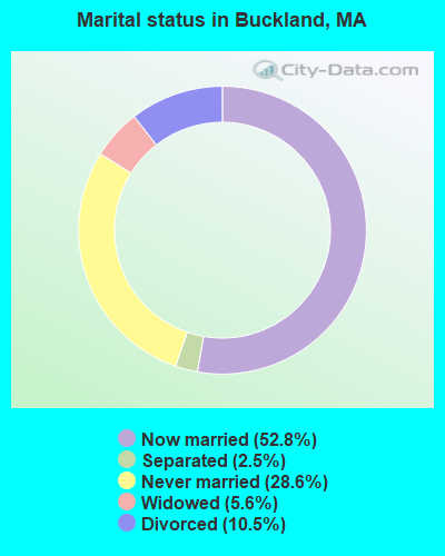
- Never married: 28.6%
- Now married: 52.8%
- Separated: 2.5%
- Widowed: 5.6%
- Divorced: 10.5%
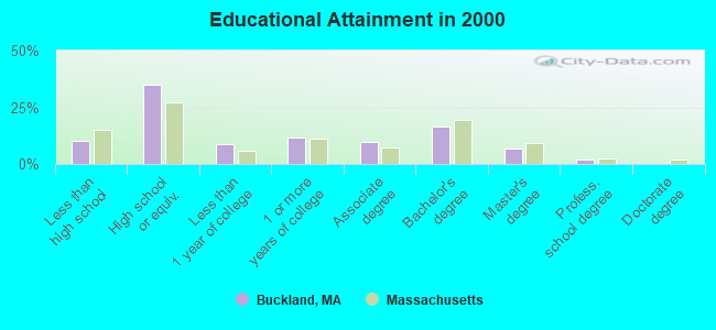
For population 25 years and over in Buckland:
- High school or higher: 89.8%
- Bachelor's degree or higher: 25.2%
- Graduate or professional degree: 8.7%
- Unemployed: 4.2%
- Mean travel time to work (commute): 23.0 minutes
| Here: | 10.0 |
| Massachusetts average: | 13.1 |


Graphs represent county-level data. Detailed 2008 Election Results
Religion statistics for Buckland, MA (based on Franklin County data)


| Religion | Adherents | Congregations |
|---|---|---|
| Catholic | 16,509 | 15 |
| Mainline Protestant | 4,617 | 38 |
| Evangelical Protestant | 2,079 | 20 |
| Other | 1,580 | 21 |
| None | 46,587 | - |
Food Environment Statistics:
| This county: | 3.63 / 10,000 pop. |
| State: | 1.98 / 10,000 pop. |
| This county: | 0.14 / 10,000 pop. |
| Massachusetts: | 0.05 / 10,000 pop. |
| Franklin County: | 1.67 / 10,000 pop. |
| State: | 2.22 / 10,000 pop. |
| This county: | 3.21 / 10,000 pop. |
| State: | 1.77 / 10,000 pop. |
| This county: | 8.10 / 10,000 pop. |
| State: | 8.76 / 10,000 pop. |
| This county: | 7.5% |
| State: | 8.1% |
| This county: | 22.2% |
| Massachusetts: | 22.5% |
| Here: | 15.1% |
| Massachusetts: | 16.5% |
Strongest AM radio stations in Buckland:
- WIZZ (1520 AM; daytime; 10 kW; GREENFIELD, MA; Owner: P. & M. RADIO, LLC)
- WNNZ (640 AM; 50 kW; WESTFIELD, MA; Owner: CLEAR CHANNEL BROADCASTING LICENSES, INC.)
- WCRN (830 AM; 50 kW; WORCESTER, MA; Owner: CARTER BROADCASTING CORPORATION)
- WVNE (760 AM; daytime; 25 kW; LEICESTER, MA; Owner: BLOUNT MASSCOM, INC.)
- WGY (810 AM; 50 kW; SCHENECTADY, NY; Owner: CLEAR CHANNEL BROADCASTING LICENSES, INC.)
- WTIC (1080 AM; 50 kW; HARTFORD, CT; Owner: INFINITY RADIO OPERATIONS INC.)
- WHMQ (1240 AM; 1 kW; GREENFIELD, MA; Owner: SAGA COMMUNICATIONS OF NEW ENGLAND, LLC)
- WRKO (680 AM; 50 kW; BOSTON, MA; Owner: ENTERCOM BOSTON LICENSE, LLC)
- WPTR (1540 AM; 50 kW; ALBANY, NY; Owner: KIMTRON, INC.)
- WHYN (560 AM; 5 kW; SPRINGFIELD, MA; Owner: CLEAR CHANNEL BROADCASTING LICENSES, INC.)
- WEEI (850 AM; 50 kW; BOSTON, MA; Owner: ENTERCOM BOSTON LICENSE, LLC)
- WALE (990 AM; 50 kW; GREENVILLE, RI; Owner: NORTH AMERICAN BROADCASTING CO., INC.)
- WKOX (1200 AM; 50 kW; FRAMINGHAM, MA; Owner: CAPSTAR TX LIMITED PARTNERSHIP)
Strongest FM radio stations in Buckland:
- WAMC-FM (90.3 FM; ALBANY, NY; Owner: WAMC)
- WPVQ (95.3 FM; GREENFIELD, MA; Owner: GREAT NORTHERN RADIO, L.L.C.)
- WRSI (93.9 FM; TURNERS FALLS, MA; Owner: GREAT NORTHERN RADIO, LLC)
- WHAI (98.3 FM; GREENFIELD, MA; Owner: SAGA COMMUNICATIONS OF NEW ENGLAND, LLC)
- WVAY (100.7 FM; WILMINGTON, VT; Owner: GREAT NORTHERN RADIO, L.L.C.)
- WEQX (102.7 FM; MANCHESTER, VT; Owner: NORTHSHIRE COMMUNICATIONS, INC.)
- WRSY (101.5 FM; MARLBORO, VT; Owner: GREAT NORTHERN RADIO, L.L.C.)
- WJAN (95.1 FM; SUNDERLAND, VT; Owner: 6 JOHNSON ROAD LICENSES, INC.)
- WGAJ (91.7 FM; DEERFIELD, MA; Owner: TRUATEES OF DEERFIELD ACADEMY)
- WFCR (88.5 FM; AMHERST, MA; Owner: UNIVERSITY OF MASSACHUSETTS)
- WHYN-FM (93.1 FM; SPRINGFIELD, MA; Owner: CLEAR CHANNEL BROADCASTING LICENSES, INC.)
- WMNB (100.1 FM; NORTH ADAMS, MA; Owner: BERKSHIRE BROADCASTING CO., INC.)
- WYRY (104.9 FM; HINSDALE, NH; Owner: TRI-VALLEY BROADCASTING CORPORATION)
- WRNX (100.9 FM; AMHERST, MA; Owner: WESTERN MASSACHUSETTS RADIO COMPANY)
- WZEC (97.5 FM; HOOSICK FALLS, NY; Owner: GREAT NORTHERN RADIO, LLC)
- WKVT-FM (92.7 FM; BRATTLEBORO, VT; Owner: SAGA COMMUNICATIONS OF NEW ENGLAND, LLC)
- WAMH (89.3 FM; AMHERST, MA; Owner: TRUSTEES OF AMHERST COLLEGE)
- WLZX (99.3 FM; NORTHAMPTON, MA; Owner: SAGA COMMUNICATIONS OF NEW ENGLAND, LLC)
- WHDQ (106.1 FM; CLAREMONT, NH; Owner: GREAT NORTHERN RADIO, L.L.C.)
- WCMK (91.9 FM; PUTNEY, VT; Owner: CHRISTIAN MINISTRIES INC)
TV broadcast stations around Buckland:
- W35BK (Channel 35; PLAINFIELD, MA; Owner: LYDIA SYLVANE STOCKWELL)
- WYDN (Channel 48; WORCESTER, MA; Owner: EDUCATIONAL PUBLIC TV CORPORATION)
- WCDC-TV (Channel 19; ADAMS, MA; Owner: YOUNG BROADCASTING OF ALBANY, INC.)
- Buckland, Massachusetts
- Fatal accident count9
- Vehicles involved in fatal accidents11
- Fatal accidents involving drunk persons:4
- Fatalities9
- Persons involved in fatal accidents16
- Pedestrians involved in fatal accidents0
- Massachusetts average
- Fatal accident count4441
- Vehicles involved in fatal accidents6267
- Fatal accidents involving drunk persons1634
- Fatalities4797
- Persons involved in fatal accidents10286
- Pedestrians involved in fatal accidents412
- National Bridge Inventory (NBI) Statistics
- 18Number of bridges
- 233ft / 71.4mTotal length
- $40,616,000Total costs
- 52,853Total average daily traffic
- 4,221Total average daily truck traffic
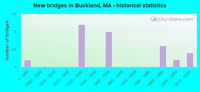
- New bridges - historical statistics
- 1Before 1900
- 61930-1939
- 51950-1959
- 31990-1999
- 12000-2009
- 22010-2019
FCC Registered Broadcast Land Mobile Towers:
4- Hogden Rd (Lat: 42.567861 Lon: -72.801194), Call Sign: KNCL523,
Assigned Frequencies: 33.4800 MHz, 33.5400 MHz, Grant Date: 11/27/1996, Expiration Date: 01/08/2002, Cancellation Date: 05/05/2002, Registrant: Buckland Fire District, Box 81, Buckland, MA 01338, Phone: (413) 772-2479
- Hogden Road (Lat: 42.567861 Lon: -72.801194), Type: Bant, Structure height: 6 m, Overall height: 18 m, Call Sign: WNUG355,
Assigned Frequencies: 33.4800 MHz, 33.5400 MHz, Grant Date: 08/24/2005, Expiration Date: 09/11/2015, Cancellation Date: 11/14/2015, Registrant: Western Mass Communications, Inc., 22 South St, Bernardston, MA 01337, Phone: (413) 648-9382, Fax: (413) 648-9036, Email:
- 45 Conway St (Lat: 42.599528 Lon: -72.735083), Call Sign: WNDF841,
Assigned Frequencies: 45.5200 MHz, Grant Date: 06/10/2015, Expiration Date: 07/23/2025, Registrant: State Of Vermont, 45 State Drive, Watterbury, VT 05671, Phone: (802) 229-0882, Email:
- South St Gardeners Falls (Lat: 42.599528 Lon: -72.733694), Call Sign: WNLF743, Licensee ID: L00007153,
Assigned Frequencies: 37.6000 MHz, Grant Date: 11/24/1998, Expiration Date: 11/24/2003, Cancellation Date: 07/12/2002, Registrant: Northeast Utilities Service Company, Hartford, CT 06141-0270, Phone: (203) 634-5745
2002 - 2018 National Fire Incident Reporting System (NFIRS) incidents
- Fire incident types reported to NFIRS in Buckland, MA
- 4947.1%Outside Fires
- 4644.2%Structure Fires
- 76.7%Other
- 21.9%Mobile Property/Vehicle Fires
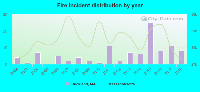 According to the data from the years 2002 - 2018 the average number of fire incidents per year is 6. The highest number of reported fire incidents - 25 took place in 2015, and the least - 0 in 2005. The data has a growing trend.
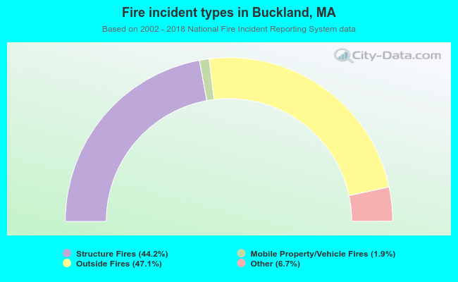 When looking into fire subcategories, the most reports belonged to: Outside Fires (47.1%), and Structure Fires (44.2%).
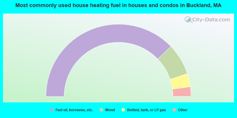
- 75.6%Fuel oil, kerosene, etc.
- 14.1%Wood
- 5.9%Bottled, tank, or LP gas
- 3.7%Electricity
- 0.6%Utility gas
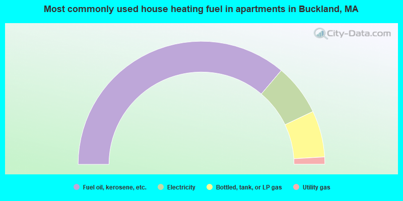
- 72.4%Fuel oil, kerosene, etc.
- 13.5%Electricity
- 12.2%Bottled, tank, or LP gas
- 1.9%Utility gas
Buckland compared to Massachusetts state average:
- Median house value below state average.
- Unemployed percentage significantly below state average.
- Black race population percentage significantly below state average.
- Hispanic race population percentage significantly below state average.
- Median age above state average.
- Foreign-born population percentage significantly below state average.
- Renting percentage below state average.
- Length of stay since moving in significantly above state average.
- Number of rooms per house significantly below state average.
- House age significantly below state average.