Burnside, Wisconsin
Submit your own pictures of this town and show them to the world
- OSM Map
- Google Map
- MSN Map
Population change since 2000: -3.4%
 |
| Males: 272 | |
| Females: 239 |
| Median resident age: | 40.3 years |
| Wisconsin median age: | 42.6 years |
Zip codes: 54747.
| Burnside: | $72,798 |
| WI: | $70,996 |
Estimated per capita income in 2022: $36,574 (it was $18,612 in 2000)
Burnside town income, earnings, and wages data
Estimated median house or condo value in 2022: $192,329 (it was $73,800 in 2000)
| Burnside: | $192,329 |
| WI: | $252,800 |
Mean prices in 2022: all housing units: $241,910; detached houses: $254,740; townhouses or other attached units: $281,807; in 2-unit structures: $204,128; in 5-or-more-unit structures: $86,444; mobile homes: $66,827
Detailed information about poverty and poor residents in Burnside, WI


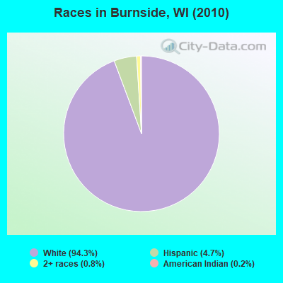
- 48294.3%White alone
- 244.7%Hispanic
- 40.8%Two or more races
- 10.2%American Indian alone
Races in Burnside detailed stats: ancestries, foreign born residents, place of birth
 Recent articles from our blog. Our writers, many of them Ph.D. graduates or candidates, create easy-to-read articles on a wide variety of topics.
Ancestries: Polish (62.9%), German (34.0%), Norwegian (10.2%), Irish (4.3%), English (4.2%), Swiss (3.4%).
Current Local Time: CST time zone
Land area: 35.0 square miles.
Population density: 15 people per square mile (very low).
24 residents are foreign born (3.4% Latin America, 1.1% Europe).
| This town: | 4.5% |
| Wisconsin: | 3.6% |
| Burnside town: | 1.3% ($983) |
| Wisconsin: | 2.0% ($2,245) |
Nearest city with pop. 50,000+: Eau Claire, WI  (30.1 miles , pop. 61,704).
Nearest city with pop. 200,000+: St. Paul, MN (91.2 miles , pop. 287,151).
Nearest city with pop. 1,000,000+: Chicago, IL (258.9 miles , pop. 2,896,016).
Nearest cities:
), ), ), ), ), ), )Latitude: 44.38 N, Longitude: 91.45 W
Area code commonly used in this area: 715
| Here: | 3.3% |
| Wisconsin: | 2.7% |
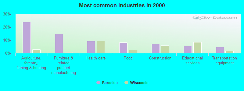
- Agriculture, forestry, fishing & hunting (23.8%)
- Furniture & related product manufacturing (14.9%)
- Health care (9.3%)
- Food (8.2%)
- Construction (7.1%)
- Educational services (5.7%)
- Transportation equipment (4.6%)
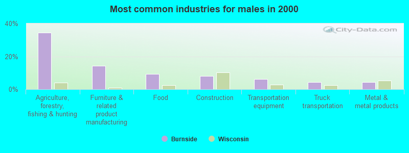
- Agriculture, forestry, fishing & hunting (34.4%)
- Furniture & related product manufacturing (14.1%)
- Food (9.2%)
- Construction (8.0%)
- Transportation equipment (6.1%)
- Truck transportation (4.3%)
- Metal & metal products (4.3%)
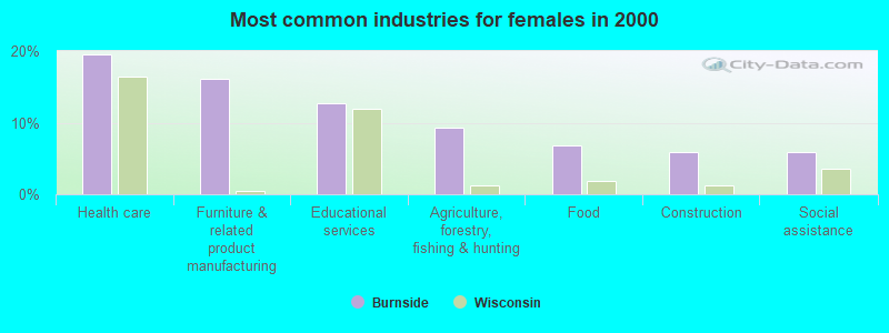
- Health care (19.5%)
- Furniture & related product manufacturing (16.1%)
- Educational services (12.7%)
- Agriculture, forestry, fishing & hunting (9.3%)
- Food (6.8%)
- Construction (5.9%)
- Social assistance (5.9%)
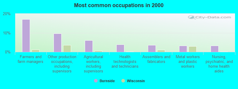
- Farmers and farm managers (17.1%)
- Other production occupations, including supervisors (9.6%)
- Agricultural workers, including supervisors (6.0%)
- Health technologists and technicians (3.9%)
- Assemblers and fabricators (3.6%)
- Metal workers and plastic workers (3.2%)
- Nursing, psychiatric, and home health aides (3.2%)
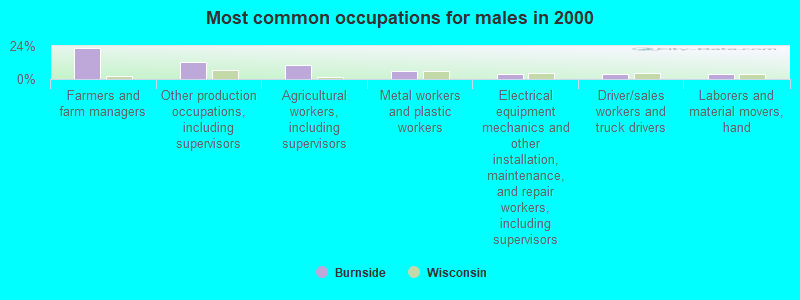
- Farmers and farm managers (22.7%)
- Other production occupations, including supervisors (12.3%)
- Agricultural workers, including supervisors (10.4%)
- Metal workers and plastic workers (5.5%)
- Electrical equipment mechanics and other installation, maintenance, and repair workers, including supervisors (3.7%)
- Driver/sales workers and truck drivers (3.7%)
- Laborers and material movers, hand (3.7%)
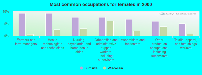
- Farmers and farm managers (9.3%)
- Health technologists and technicians (9.3%)
- Nursing, psychiatric, and home health aides (7.6%)
- Other office and administrative support workers, including supervisors (7.6%)
- Assemblers and fabricators (6.8%)
- Other production occupations, including supervisors (5.9%)
- Textile, apparel, and furnishings workers (5.1%)
Average climate in Burnside, Wisconsin
Based on data reported by over 4,000 weather stations


(lower is better)
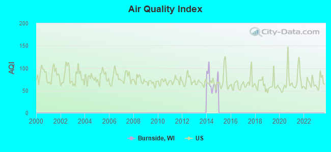
Air Quality Index (AQI) level in 2014 was 70.2. This is about average.
| City: | 70.2 |
| U.S.: | 72.6 |
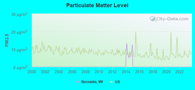
Particulate Matter (PM2.5) [µg/m3] level in 2014 was 8.28. This is about average. Closest monitor was 24.7 miles away from the city center.
| City: | 8.28 |
| U.S.: | 8.11 |
Tornado activity:
Burnside-area historical tornado activity is near Wisconsin state average. It is 9% greater than the overall U.S. average.
On 6/4/1958, a category F4 (max. wind speeds 207-260 mph) tornado 28.3 miles away from the Burnside town center killed 4 people and injured 3 people and caused between $500,000 and $5,000,000 in damages.
On 6/4/1958, a category F5 (max. wind speeds 261-318 mph) tornado 47.6 miles away from the town center killed 21 people and injured 74 people and caused between $5,000,000 and $50,000,000 in damages.
Earthquake activity:
Burnside-area historical earthquake activity is significantly above Wisconsin state average. It is 34% greater than the overall U.S. average.On 7/9/1975 at 14:54:15, a magnitude 4.6 (4.6 MB, Class: Light, Intensity: IV - V) earthquake occurred 241.6 miles away from Burnside center
On 6/28/2004 at 06:10:52, a magnitude 4.2 (4.2 MW, Depth: 6.2 mi) earthquake occurred 239.6 miles away from Burnside center
On 4/18/2008 at 09:36:59, a magnitude 5.4 (5.1 MB, 4.8 MS, 5.4 MW, 5.2 MW, Class: Moderate, Intensity: VI - VII) earthquake occurred 449.6 miles away from the city center
On 6/5/1993 at 01:24:53, a magnitude 4.1 (4.1 LG, Depth: 6.2 mi) earthquake occurred 253.2 miles away from the city center
On 6/10/1987 at 23:48:54, a magnitude 5.1 (4.9 MB, 4.4 MS, 4.6 MS, 5.1 LG) earthquake occurred 426.3 miles away from Burnside center
On 4/18/2008 at 09:36:59, a magnitude 5.2 (5.2 MW, Depth: 8.9 mi) earthquake occurred 449.6 miles away from Burnside center
Magnitude types: regional Lg-wave magnitude (LG), body-wave magnitude (MB), surface-wave magnitude (MS), moment magnitude (MW)
Natural disasters:
The number of natural disasters in Trempealeau County (14) is near the US average (15).Major Disasters (Presidential) Declared: 11
Emergencies Declared: 2
Causes of natural disasters: Floods: 10, Storms: 8, Tornadoes: 5, Heavy Rains: 2, Winds: 2, Drought: 1, Flash Flood: 1, Hurricane: 1, Landslide: 1, Other: 1 (Note: some incidents may be assigned to more than one category).
Hospitals and medical centers near Burnside:
Colleges/universities with over 2000 students nearest to Burnside:
- Winona State University (about 26 miles; Winona, MN; Full-time enrollment: 8,397)
- Saint Mary's University of Minnesota (about 27 miles; Winona, MN; FT enrollment: 4,022)
- Chippewa Valley Technical College (about 29 miles; Eau Claire, WI; FT enrollment: 4,038)
- University of Wisconsin-Eau Claire (about 30 miles; Eau Claire, WI; FT enrollment: 10,143)
- Western Technical College (about 41 miles; La Crosse, WI; FT enrollment: 3,377)
- University of Wisconsin-La Crosse (about 41 miles; La Crosse, WI; FT enrollment: 9,837)
- Viterbo University (about 42 miles; La Crosse, WI; FT enrollment: 2,848)
Points of interest:
Cemetery: Cripps Cemetery (1). Display/hide its location on the map
Creeks: Sport Valley Creek (A), Traverse Valley Creek (B), Borst Valley Creek (C). Display/hide their locations on the map
| This town: | 2.6 people |
| Wisconsin: | 2.4 people |
| This town: | 75.8% |
| Whole state: | 64.4% |
| This town: | 7.2% |
| Whole state: | 7.3% |
No gay or lesbian households reported
| This town: | 6.5% |
| Whole state: | 8.7% |
| This town: | 2.4% |
| Whole state: | 3.7% |
For population 15 years and over in Burnside:
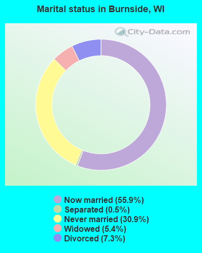
- Never married: 30.9%
- Now married: 55.9%
- Separated: 0.5%
- Widowed: 5.4%
- Divorced: 7.3%
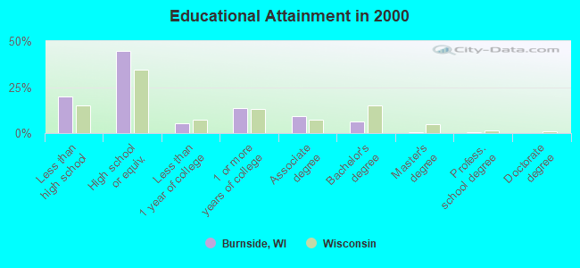
For population 25 years and over in Burnside:
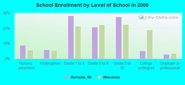
- High school or higher: 80.3%
- Bachelor's degree or higher: 7.2%
- Graduate or professional degree: 0.8%
- Unemployed: 3.4%
- Mean travel time to work (commute): 19.6 minutes
| Here: | 11.3 |
| Wisconsin average: | 11.0 |
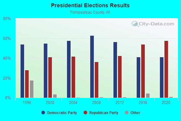
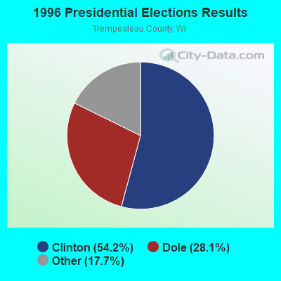
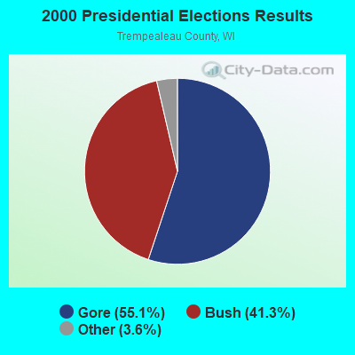
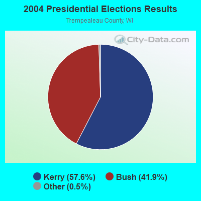
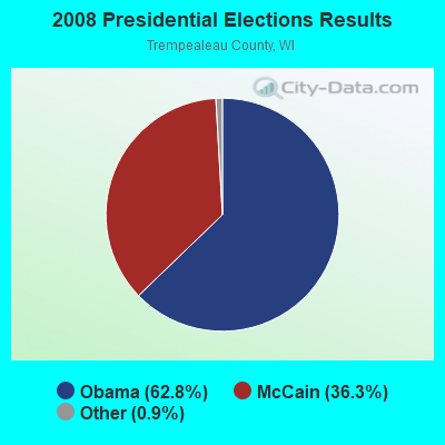
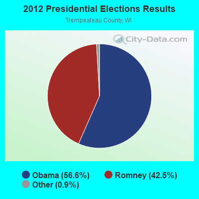
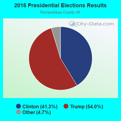
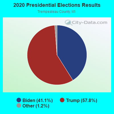
Graphs represent county-level data. Detailed 2008 Election Results
Religion statistics for Burnside, WI (based on Trempealeau County data)
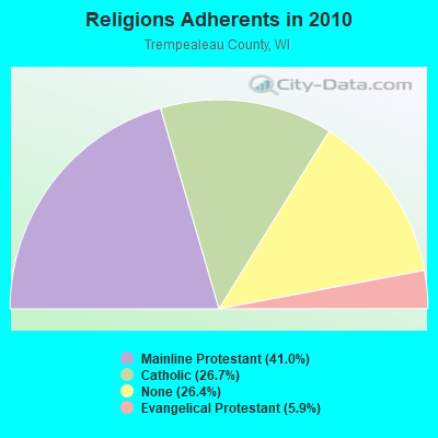
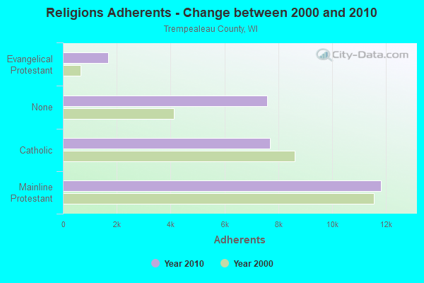
| Religion | Adherents | Congregations |
|---|---|---|
| Mainline Protestant | 11,821 | 28 |
| Catholic | 7,700 | 8 |
| Evangelical Protestant | 1,688 | 15 |
| Other | 10 | 2 |
| None | 7,597 | - |
Food Environment Statistics:
| Trempealeau County: | 2.16 / 10,000 pop. |
| Wisconsin: | 1.86 / 10,000 pop. |
| Trempealeau County: | 1.08 / 10,000 pop. |
| Wisconsin: | 0.38 / 10,000 pop. |
| Trempealeau County: | 5.04 / 10,000 pop. |
| Wisconsin: | 4.12 / 10,000 pop. |
| Here: | 8.64 / 10,000 pop. |
| Wisconsin: | 8.64 / 10,000 pop. |
| Trempealeau County: | 8.4% |
| Wisconsin: | 7.6% |
| Trempealeau County: | 28.4% |
| Wisconsin: | 27.5% |
| This county: | 15.2% |
| Wisconsin: | 13.0% |
Strongest AM radio stations in Burnside:
- WMEQ (880 AM; 10 kW; MENOMONIE, WI; Owner: CAPSTAR TX LIMITED PARTNERSHIP)
- WCTS (1030 AM; 50 kW; MAPLEWOOD, MN; Owner: CNTL. BAPT. THEO/AL SEMI MINNEAPOLIS)
- WAYY (790 AM; 5 kW; EAU CLAIRE, WI; Owner: MAVERICK MEDIA OF EAU CLAIRE LICENSE LLC)
- WSPT (1010 AM; 50 kW; STEVENS POINT, WI)
- WCCO (830 AM; 50 kW; MINNEAPOLIS, MN; Owner: INFINITY MEDIA CORPORATION)
- KFAN (1130 AM; 50 kW; MINNEAPOLIS, MN; Owner: AMFM RADIO LICENSES, L.L.C.)
- KAGE (1380 AM; 4 kW; WINONA, MN; Owner: KAGE, INC.)
- KSTP (1500 AM; 50 kW; ST. PAUL, MN; Owner: KSTP-AM, LLC (DELAWARE))
- WKTY (580 AM; 5 kW; LA CROSSE, WI; Owner: FAMILY RADIO, INC.)
- KTIS (900 AM; 25 kW; MINNEAPOLIS, MN; Owner: NORTHWESTERN COLLEGE)
- WEAQ (1150 AM; 5 kW; CHIPPEWA FALLS, WI; Owner: MAVERICK MEDIA OF EAU CLAIRE LICENSE LLC)
- WSAU (550 AM; 20 kW; WAUSAU, WI; Owner: WRIG, INC.)
- WEBC (560 AM; 50 kW; DULUTH, MN)
Strongest FM radio stations in Burnside:
- WHTL-FM (102.3 FM; WHITEHALL, WI; Owner: THE WHTL GROUP, L.L.C.)
- WAXX (104.5 FM; EAU CLAIRE, WI; Owner: MAVERICK MEDIA OF EAU CLAIRE LICENSE LLC)
- KHME (101.1 FM; WINONA, MN; Owner: KAGE, INC.)
- KQAL (89.5 FM; WINONA, MN; Owner: WINONA STATE UNIVERSITY)
- WHLA (90.3 FM; LA CROSSE, WI; Owner: STATE OF WISCONSIN - EDUCATIONAL COMMUNICATIONS BOARD)
- WIZM-FM (93.3 FM; LA CROSSE, WI; Owner: FAMILY RADIO, INC.)
- WUEC (89.7 FM; EAU CLAIRE, WI; Owner: BOARD OF REGENTS, UNIVERSITY OF WISCONSIN SYSTEM)
- WLSU (88.9 FM; LA CROSSE, WI; Owner: BD.OF REGENTS, UNIV.OF WISCONSIN SYSTEM)
- KAGE-FM (95.3 FM; WINONA, MN; Owner: KAGE, INC.)
- KXLC (91.1 FM; LA CRESCENT, MN; Owner: MINNESOTA PUBLIC RADIO)
- WDMO (95.9 FM; DURAND, WI; Owner: ZOE COMMUNICATIONS, INC.)
- WFBZ (105.5 FM; TREMPEALEAU, WI; Owner: S & S BROADCASTING)
- WBIZ-FM (100.7 FM; EAU CLAIRE, WI; Owner: CAPSTAR TX LIMITED PARTNERSHIP)
- KMFX-FM (102.5 FM; LAKE CITY, MN; Owner: CLEAR CHANNEL BROADCASTING LICENSES, INC.)
- K203BR (88.5 FM; WINONA, MN; Owner: FAITH SOUND, INC.)
- WWIS-FM (99.7 FM; BLACK RIVER FALLS, WI; Owner: WWIS RADIO, INC.)
- K280EI (103.9 FM; WINONA, MN; Owner: MARATHON MEDIA GROUP, L.L.C.)
TV broadcast stations around Burnside:
- WKBT (Channel 8; LA CROSSE, WI; Owner: QUEENB TELEVISION, LLC)
- WEAU-TV (Channel 13; EAU CLAIRE, WI; Owner: WEAU LICENSEE CORP.)
- WQOW-TV (Channel 18; EAU CLAIRE, WI; Owner: WXOW-WQOW TELEVISION, INC.)
- WDLS-LP (Channel 35; TOMAH, WI; Owner: MAGNUM RADIO, INC.)
- WXOW-TV (Channel 19; LA CROSSE, WI; Owner: WXOW-WQOW TELEVISION, INC.)
- WLAX (Channel 25; LA CROSSE, WI; Owner: GRANT MEDIA, INC.)
- WHLA-TV (Channel 31; LA CROSSE, WI; Owner: WISCONSIN EDUCATIONAL COMMUNICATIONS BOARD)
- K38CL (Channel 38; WINONA, MN; Owner: FOX TELEVISION STATIONS, INC.)
- K62EV (Channel 62; WINONA, MN; Owner: KTTC TELEVISION, INC.)
- National Bridge Inventory (NBI) Statistics
- 20Number of bridges
- 108ft / 33.0mTotal length
- $632,000Total costs
- 14,988Total average daily traffic
- 1,016Total average daily truck traffic
- 17,942Total future (year 2038) average daily traffic
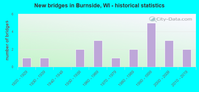
- New bridges - historical statistics
- 11920-1929
- 11930-1939
- 21950-1959
- 31960-1969
- 11970-1979
- 21980-1989
- 51990-1999
- 32000-2009
- 22010-2019
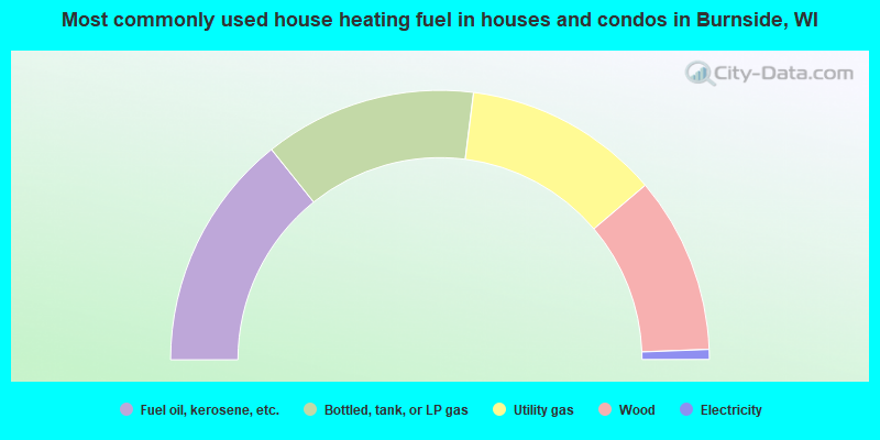
- 28.5%Fuel oil, kerosene, etc.
- 25.5%Bottled, tank, or LP gas
- 23.6%Utility gas
- 21.2%Wood
- 1.2%Electricity
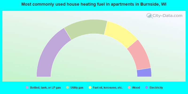
- 32.5%Bottled, tank, or LP gas
- 25.0%Utility gas
- 20.0%Fuel oil, kerosene, etc.
- 17.5%Wood
- 5.0%Electricity
Burnside compared to Wisconsin state average:
- Unemployed percentage significantly below state average.
- Black race population percentage significantly below state average.
- Renting percentage below state average.
- Length of stay since moving in significantly above state average.
- Number of rooms per house significantly below state average.
- House age significantly below state average.
- Number of college students below state average.
- Percentage of population with a bachelor's degree or higher significantly below state average.