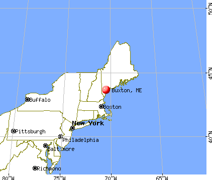
Buxton, Maine

Submit your own pictures of this town and show them to the world
- OSM Map
- General Map
- Google Map
- MSN Map
Population change since 2000: +7.8%
 |
| Males: 4,050 | |
| Females: 3,984 |
| Median resident age: | 41.5 years |
| Maine median age: | 43.0 years |
Zip codes: 04093.
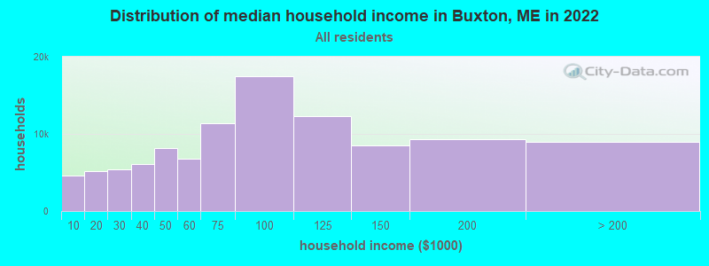
| Buxton: | $91,933 |
| ME: | $69,543 |
Estimated per capita income in 2022: $41,052 (it was $20,179 in 2000)
Buxton town income, earnings, and wages data
Estimated median house or condo value in 2022: $355,508 (it was $111,300 in 2000)
| Buxton: | $355,508 |
| ME: | $290,600 |
Mean prices in 2022: all housing units: $451,552; detached houses: $470,451; townhouses or other attached units: $577,335; in 2-unit structures: $383,179; in 3-to-4-unit structures: $310,696; in 5-or-more-unit structures: $252,113; mobile homes: $105,501
Detailed information about poverty and poor residents in Buxton, ME
Compare current foreclosures near Buxton, ME:
| Photo | Address | Area | Beds / Baths | Price | Details |
|---|---|---|---|---|---|

|
#1
Webster Rd
Buxton, ME 04093
|
- sq. feet
|
- baths - beds |
show details | |

|
#2
Narragansett Trl
Buxton, ME 04093
|
- sq. feet
|
- baths - beds |
show details | |

|
#3
Line Rd
Gorham, ME 04038
|
1,086 sq. feet
|
1 baths 3 beds |
show details | |

|
#4
Cram Rd
East Baldwin, ME 04024
|
982 sq. feet
|
1 baths 2 beds |
show details | |

|
#5
Motorcycle Dr
Windham, ME 04062
|
2,772 sq. feet
|
2 baths 3 beds |
show details | |

|
#6
High St
Windham, ME 04062
|
933 sq. feet
|
1 baths 2 beds |
show details | |

|
#7
Bridge St
Westbrook, ME 04092
|
1,268 sq. feet
|
1 baths 2 beds |
show details | |

|
#8
Fletcher St
Kennebunk, ME 04043
|
1,638 sq. feet
|
1 baths 3 beds |
show details | |

|
#9
Running Brook Rd
Windham, ME 04062
|
1,749 sq. feet
|
2 baths 3 beds |
show details | |

|
#10
Emerson Dr
Windham, ME 04062
|
1,080 sq. feet
|
1 baths 3 beds |
show details |
| Photo | Address | Area | Beds / Baths | Price | Details |
|---|---|---|---|---|---|

|
#11
Cottage Rd
Windham, ME 04062
|
1,404 sq. feet
|
1 baths 2 beds |
show details | |

|
#12
Windham Center Rd
Windham, ME 04062
|
1,576 sq. feet
|
1 baths 3 beds |
show details | |

|
#13
Scammon St
Saco, ME 04072
|
1,340 sq. feet
|
2 baths 4 beds |
show details | |

|
#14
Haskell St
Westbrook, ME 04092
|
1,573 sq. feet
|
1 baths 3 beds |
show details | |

|
#15
Coach Rd
South Portland, ME 04106
|
1,300 sq. feet
|
2 baths 3 beds |
show details | |

|
#16
Goldie Ln
Standish, ME 04084
|
2,273 sq. feet
|
1 baths 3 beds |
show details | |

|
#17
Jennifer Way
Gorham, ME 04038
|
1,414 sq. feet
|
1 baths 3 beds |
show details | |

|
#18
Church St
Westbrook, ME 04092
|
1,529 sq. feet
|
1 baths 3 beds |
show details | |

|
#19
Dollys Way
Scarborough, ME 04074
|
1,821 sq. feet
|
2 baths 3 beds |
show details | |

|
#20
Charles Rd
Saco, ME 04072
|
768 sq. feet
|
1 baths 1 beds |
show details |
| Photo | Address | Area | Beds / Baths | Price | Details |
|---|---|---|---|---|---|

|
#21
Saco St Unit 2
Westbrook, ME 04092
|
1,725 sq. feet
|
2 baths 4 beds |
show details | |

|
#22
Gray Rd
Cumberland Center, ME 04021
|
- sq. feet
|
- baths - beds |
show details | |

|
#23
Congress St # 2
Portland, ME 04102
|
- sq. feet
|
- baths - beds |
show details | |

|
#24
N Kelsey St Apt 2
South Portland, ME 04106
|
- sq. feet
|
- baths - beds |
show details | |

|
#25
Scarborough Downs Rd
Scarborough, ME 04074
|
- sq. feet
|
- baths - beds |
show details | |

|
#26
Lambert St # C2
Portland, ME 04103
|
- sq. feet
|
- baths - beds |
show details | |

|
#27
Biddeford Rd
Alfred, ME 04002
|
- sq. feet
|
- baths - beds |
show details | |

|
#28
Congress St Unit 307
Portland, ME 04101
|
- sq. feet
|
- baths - beds |
show details | |

|
#29
Cumberland Ave # 302
Portland, ME 04101
|
- sq. feet
|
- baths - beds |
show details | |

|
#30
Ocean Ave
Portland, ME 04103
|
- sq. feet
|
- baths - beds |
show details |
| Photo | Address | Area | Beds / Baths | Price | Details |
|---|---|---|---|---|---|

|
#31
Liberty Way
Portland, ME 04103
|
- sq. feet
|
- baths - beds |
show details | |

|
#32
Congress St
Portland, ME 04101
|
- sq. feet
|
- baths - beds |
show details | |

|
#33
India St # 1
Portland, ME 04101
|
- sq. feet
|
- baths - beds |
show details | |

|
#34
Ocean Ave
Portland, ME 04103
|
- sq. feet
|
- baths - beds |
show details | |

|
#35
Lincoln Rd
Saco, ME 04072
|
- sq. feet
|
- baths - beds |
show details | |

|
#36
Cape Woods Dr
Cape Elizabeth, ME 04107
|
- sq. feet
|
- baths - beds |
show details | |

|
#37
Ross Corner Rd
Shapleigh, ME 04076
|
- sq. feet
|
- baths - beds |
show details | |

|
#38
Emma Ln
Gorham, ME 04038
|
- sq. feet
|
- baths - beds |
show details | |

|
#39
Pleasant Ave
Portland, ME 04103
|
- sq. feet
|
- baths - beds |
show details | |

|
#40
Park Ave Apt 2
Portland, ME 04101
|
- sq. feet
|
- baths - beds |
show details |
| Photo | Address | Area | Beds / Baths | Price | Details |
|---|---|---|---|---|---|

|
#41
Wainwright Cir W
South Portland, ME 04106
|
- sq. feet
|
- baths - beds |
show details | |

|
#42
Main St Apt 2
Biddeford, ME 04005
|
- sq. feet
|
- baths - beds |
show details | |

|
#43
Liza Harmon Dr Apt 128
Westbrook, ME 04092
|
- sq. feet
|
- baths - beds |
show details | |

|
#44
Stagecoach Dr
Old Orchard Beach, ME 04064
|
- sq. feet
|
- baths - beds |
show details | |

|
#45
Cape Rd
Limington, ME 04049
|
- sq. feet
|
- baths - beds |
show details | |

|
#46
Ballantyne Dr
Scarborough, ME 04074
|
- sq. feet
|
- baths - beds |
show details | |

|
#47
Forest St
Saco, ME 04072
|
- sq. feet
|
- baths - beds |
show details | |

|
#48
Devereaux Cir
South Portland, ME 04106
|
- sq. feet
|
- baths - beds |
show details | |

|
#49
Us Route 1, Apt 11
Scarborough, ME 04074
|
- sq. feet
|
- baths - beds |
show details | |

|
Check over 1 million property listings on Foreclosure.com!
|
browse all offers | |||

- 7,72996.2%White alone
- 1191.5%Two or more races
- 720.9%Asian alone
- 540.7%Hispanic
- 430.5%Black alone
- 140.2%American Indian alone
- 30.04%Other race alone
Races in Buxton detailed stats: ancestries, foreign born residents, place of birth
According to our research of Maine and other state lists, there were 14 registered sex offenders living in Buxton, Maine as of April 23, 2024.
The ratio of all residents to sex offenders in Buxton is 574 to 1.
The ratio of registered sex offenders to all residents in this city is near the state average.
Type |
2009 |
2010 |
2011 |
2012 |
2013 |
2014 |
2015 |
2016 |
2017 |
2018 |
2019 |
2020 |
2021 |
2022 |
|---|---|---|---|---|---|---|---|---|---|---|---|---|---|---|
| Murders (per 100,000) | 0 (0.0) | 0 (0.0) | 0 (0.0) | 0 (0.0) | 0 (0.0) | 0 (0.0) | 0 (0.0) | 0 (0.0) | 0 (0.0) | 0 (0.0) | 0 (0.0) | 0 (0.0) | 0 (0.0) | 0 (0.0) |
| Rapes (per 100,000) | 0 (0.0) | 2 (24.9) | 1 (12.4) | 1 (12.4) | 1 (12.3) | 2 (24.7) | 3 (36.7) | 0 (0.0) | 2 (24.3) | 1 (12.1) | 3 (35.9) | 0 (0.0) | 2 (23.8) | 4 (46.9) |
| Robberies (per 100,000) | 0 (0.0) | 3 (37.3) | 3 (37.3) | 0 (0.0) | 0 (0.0) | 3 (37.1) | 2 (24.5) | 0 (0.0) | 1 (12.2) | 1 (12.1) | 0 (0.0) | 4 (47.8) | 0 (0.0) | 0 (0.0) |
| Assaults (per 100,000) | 2 (24.6) | 2 (24.9) | 0 (0.0) | 2 (24.7) | 10 (123.4) | 4 (49.4) | 6 (73.4) | 9 (110.1) | 13 (158.1) | 7 (84.5) | 9 (107.8) | 11 (131.6) | 8 (95.2) | 4 (46.9) |
| Burglaries (per 100,000) | 14 (172.0) | 22 (273.8) | 37 (460.6) | 32 (395.9) | 25 (308.5) | 27 (333.5) | 19 (232.6) | 23 (281.5) | 13 (158.1) | 9 (108.6) | 4 (47.9) | 8 (95.7) | 13 (154.7) | 11 (129.0) |
| Thefts (per 100,000) | 46 (565.2) | 67 (834.0) | 59 (734.5) | 70 (866.0) | 68 (839.2) | 85 (1,050) | 64 (783.4) | 49 (599.7) | 54 (656.8) | 51 (615.6) | 34 (407.4) | 49 (586.1) | 58 (690.3) | 59 (691.8) |
| Auto thefts (per 100,000) | 3 (36.9) | 8 (99.6) | 1 (12.4) | 2 (24.7) | 5 (61.7) | 9 (111.2) | 7 (85.7) | 1 (12.2) | 3 (36.5) | 4 (48.3) | 2 (24.0) | 5 (59.8) | 4 (47.6) | 4 (46.9) |
| Arson (per 100,000) | 0 (0.0) | 0 (0.0) | 0 (0.0) | 0 (0.0) | 1 (12.3) | 0 (0.0) | 1 (12.2) | 0 (0.0) | 0 (0.0) | 0 (0.0) | 0 (0.0) | 1 (12.0) | 0 (0.0) | 1 (11.7) |
| City-Data.com crime index | 42.5 | 96.6 | 83.8 | 79.2 | 94.7 | 115.0 | 105.9 | 66.7 | 95.0 | 66.3 | 71.9 | 75.6 | 80.3 | 87.4 |
The City-Data.com crime index weighs serious crimes and violent crimes more heavily. Higher means more crime, U.S. average is 246.1. It adjusts for the number of visitors and daily workers commuting into cities.
Crime rate in Buxton detailed stats: murders, rapes, robberies, assaults, burglaries, thefts, arson
Full-time law enforcement employees in 2021, including police officers: 14 (8 officers - 6 male; 2 female).
| Officers per 1,000 residents here: | 0.95 |
| Maine average: | 1.71 |
 Recent articles from our blog. Our writers, many of them Ph.D. graduates or candidates, create easy-to-read articles on a wide variety of topics.

 | Maine weather thread (3207 replies) |
| Moving to ME from Hawaii (10 replies) |
| Will Portland home prices keep going up? (46 replies) |
| Public school question (5 replies) |
| Buxton Schools (2 replies) |
| Moving to Maine in October...Safe & Affordable near Portland (10 replies) |
Latest news from Buxton, ME collected exclusively by city-data.com from local newspapers, TV, and radio stations
Ancestries: English (20.6%), Irish (16.5%), French (14.3%), United States (11.0%), French Canadian (7.7%), Italian (7.6%).
Current Local Time: EST time zone
Incorporated on 07/14/1762
Elevation: 186 feet
Land area: 40.5 square miles.
Population density: 198 people per square mile (very low).
163 residents are foreign born (0.9% Europe, 0.7% North America, 0.5% Asia).
| This town: | 2.2% |
| Maine: | 2.9% |
| Buxton town: | 1.2% ($1,325) |
| Maine: | 1.5% ($1,417) |
Nearest city with pop. 50,000+: Portland, ME  (13.7 miles , pop. 64,249).
Nearest city with pop. 200,000+: Boston, MA (95.0 miles , pop. 589,141).
Nearest city with pop. 1,000,000+: Bronx, NY (257.5 miles , pop. 1,332,650).
Nearest cities:
), ), ), ), )Latitude: 43.64 N, Longitude: 70.54 W
Area code commonly used in this area: 207

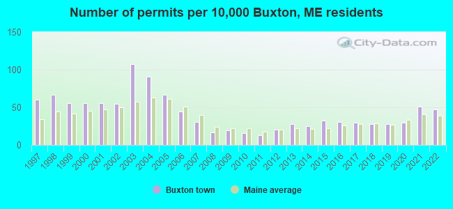
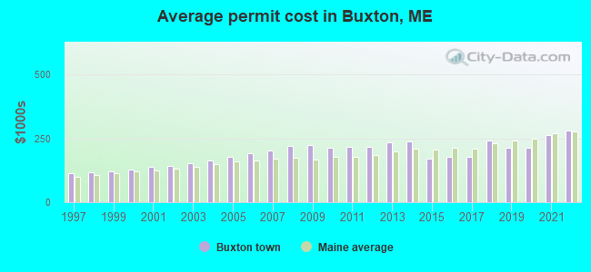
Single-family new house construction building permits:
- 2022: 35 buildings, average cost: $279,400
- 2021: 38 buildings, average cost: $262,500
- 2020: 22 buildings, average cost: $214,300
- 2019: 21 buildings, average cost: $214,300
- 2018: 21 buildings, average cost: $240,000
- 2017: 22 buildings, average cost: $178,300
- 2016: 23 buildings, average cost: $178,300
- 2015: 24 buildings, average cost: $170,000
- 2014: 19 buildings, average cost: $239,400
- 2013: 21 buildings, average cost: $232,900
- 2012: 15 buildings, average cost: $218,100
- 2011: 10 buildings, average cost: $217,800
- 2010: 12 buildings, average cost: $213,000
- 2009: 14 buildings, average cost: $224,200
- 2008: 13 buildings, average cost: $219,000
- 2007: 23 buildings, average cost: $201,500
- 2006: 33 buildings, average cost: $189,600
- 2005: 50 buildings, average cost: $175,800
- 2004: 68 buildings, average cost: $161,900
- 2003: 80 buildings, average cost: $152,100
- 2002: 41 buildings, average cost: $141,800
- 2001: 42 buildings, average cost: $139,300
- 2000: 42 buildings, average cost: $128,800
- 1999: 42 buildings, average cost: $121,900
- 1998: 50 buildings, average cost: $116,500
- 1997: 45 buildings, average cost: $112,100
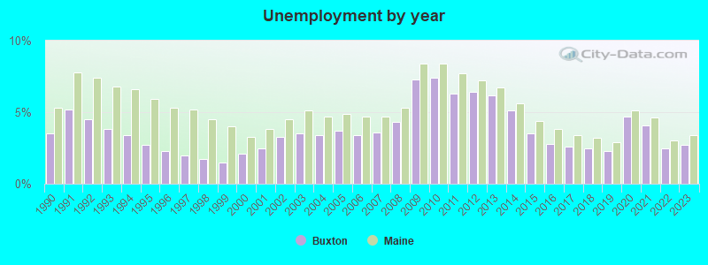
| Here: | 2.7% |
| Maine: | 3.4% |
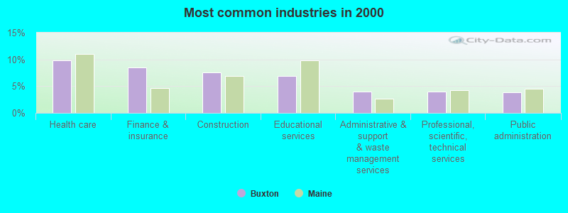
- Health care (9.8%)
- Finance & insurance (8.5%)
- Construction (7.6%)
- Educational services (7.0%)
- Administrative & support & waste management services (4.0%)
- Professional, scientific, technical services (4.0%)
- Public administration (3.8%)
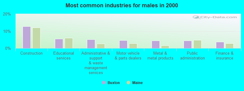
- Construction (12.8%)
- Educational services (5.5%)
- Administrative & support & waste management services (5.1%)
- Motor vehicle & parts dealers (4.6%)
- Metal & metal products (4.4%)
- Public administration (4.3%)
- Finance & insurance (3.6%)
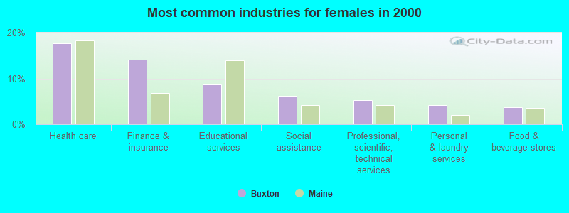
- Health care (17.7%)
- Finance & insurance (14.1%)
- Educational services (8.6%)
- Social assistance (6.2%)
- Professional, scientific, technical services (5.3%)
- Personal & laundry services (4.1%)
- Food & beverage stores (3.7%)
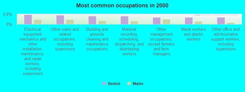
- Electrical equipment mechanics and other installation, maintenance, and repair workers, including supervisors (4.6%)
- Other sales and related occupations, including supervisors (4.4%)
- Building and grounds cleaning and maintenance occupations (4.0%)
- Material recording, scheduling, dispatching, and distributing workers (3.9%)
- Other management occupations, except farmers and farm managers (3.4%)
- Metal workers and plastic workers (3.3%)
- Other office and administrative support workers, including supervisors (3.3%)
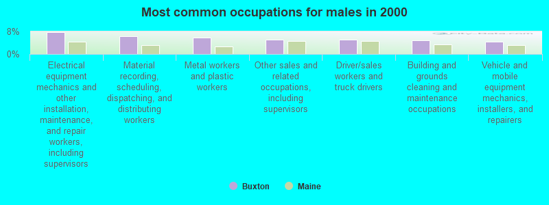
- Electrical equipment mechanics and other installation, maintenance, and repair workers, including supervisors (7.8%)
- Material recording, scheduling, dispatching, and distributing workers (6.4%)
- Metal workers and plastic workers (5.7%)
- Other sales and related occupations, including supervisors (5.2%)
- Driver/sales workers and truck drivers (5.1%)
- Building and grounds cleaning and maintenance occupations (4.7%)
- Vehicle and mobile equipment mechanics, installers, and repairers (4.3%)

- Information and record clerks, except customer service representatives (6.6%)
- Other office and administrative support workers, including supervisors (5.3%)
- Secretaries and administrative assistants (5.0%)
- Preschool, kindergarten, elementary, and middle school teachers (4.8%)
- Counselors, social workers, and other community and social service specialists (4.4%)
- Bookkeeping, accounting, and auditing clerks (3.9%)
- Registered nurses (3.8%)
Average climate in Buxton, Maine
Based on data reported by over 4,000 weather stations


(lower is better)
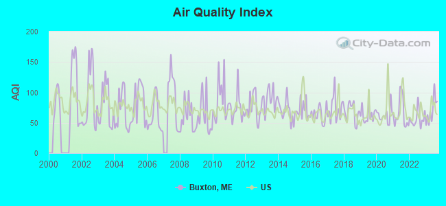
Air Quality Index (AQI) level in 2023 was 70.4. This is about average.
| City: | 70.4 |
| U.S.: | 72.6 |
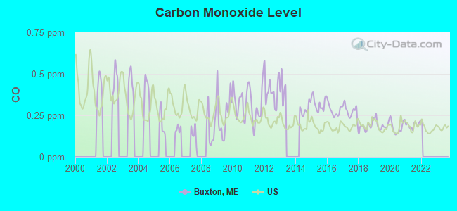
Carbon Monoxide (CO) [ppm] level in 2021 was 0.192. This is better than average. Closest monitor was 13.6 miles away from the city center.
| City: | 0.192 |
| U.S.: | 0.251 |
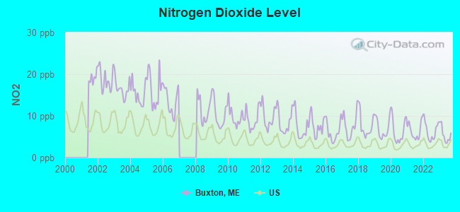
Nitrogen Dioxide (NO2) [ppb] level in 2023 was 5.47. This is about average. Closest monitor was 13.6 miles away from the city center.
| City: | 5.47 |
| U.S.: | 5.11 |
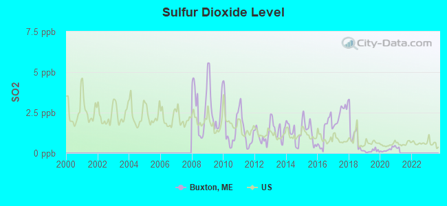
Sulfur Dioxide (SO2) [ppb] level in 2020 was 0.222. This is significantly better than average. Closest monitor was 9.1 miles away from the city center.
| City: | 0.222 |
| U.S.: | 1.515 |
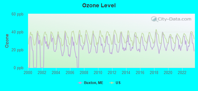
Ozone [ppb] level in 2023 was 29.7. This is about average. Closest monitor was 4.7 miles away from the city center.
| City: | 29.7 |
| U.S.: | 33.3 |
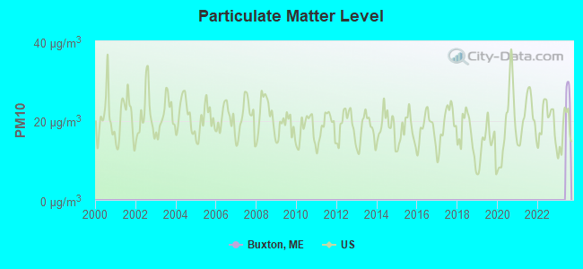
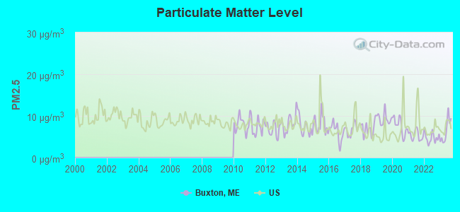
Particulate Matter (PM2.5) [µg/m3] level in 2023 was 6.46. This is better than average. Closest monitor was 9.0 miles away from the city center.
| City: | 6.46 |
| U.S.: | 8.11 |
Tornado activity:
Buxton-area historical tornado activity is above Maine state average. It is 73% smaller than the overall U.S. average.
On 10/10/1966, a category F2 (max. wind speeds 113-157 mph) tornado 18.6 miles away from the Buxton town center caused between $5000 and $50,000 in damages.
On 6/9/1953, a category F3 (max. wind speeds 158-206 mph) tornado 50.9 miles away from the town center injured 5 people and caused between $5000 and $50,000 in damages.
Earthquake activity:
Buxton-area historical earthquake activity is significantly above Maine state average. It is 74% smaller than the overall U.S. average.On 10/16/2012 at 23:12:25, a magnitude 4.7 (4.7 ML, Depth: 10.0 mi, Class: Light, Intensity: IV - V) earthquake occurred 6.4 miles away from the city center
On 4/20/2002 at 10:50:47, a magnitude 5.3 (5.3 ML, Depth: 3.0 mi, Class: Moderate, Intensity: VI - VII) earthquake occurred 168.2 miles away from the city center
On 1/19/1982 at 00:14:42, a magnitude 4.7 (4.5 MB, 4.7 MD, 4.5 LG) earthquake occurred 54.0 miles away from Buxton center
On 4/20/2002 at 10:50:47, a magnitude 5.2 (5.2 MB, 4.2 MS, 5.2 MW, 5.0 MW) earthquake occurred 168.6 miles away from Buxton center
On 10/7/1983 at 10:18:46, a magnitude 5.3 (5.1 MB, 5.3 LG, 5.1 ML) earthquake occurred 191.1 miles away from the city center
On 8/21/1996 at 07:54:14, a magnitude 3.8 (3.8 LG, 3.6 LG, Depth: 6.2 mi, Class: Light, Intensity: II - III) earthquake occurred 55.5 miles away from Buxton center
Magnitude types: regional Lg-wave magnitude (LG), body-wave magnitude (MB), duration magnitude (MD), local magnitude (ML), surface-wave magnitude (MS), moment magnitude (MW)
Natural disasters:
The number of natural disasters in York County (31) is a lot greater than the US average (15).Major Disasters (Presidential) Declared: 23
Emergencies Declared: 8
Causes of natural disasters: Floods: 21, Storms: 16, Winter Storms: 6, Snows: 5, Winds: 3, Heavy Rains: 2, Hurricanes: 2, Blizzard: 1, Ice Storm: 1, Mudslide: 1, Snowfall: 1, Snowstorm: 1, Tornado: 1, Tropical Storm: 1 (Note: some incidents may be assigned to more than one category).
Hospitals and medical centers near Buxton:
- GORHAM HEALTH CENTER (Nursing Home, about 6 miles away; GORHAM, ME)
- GORHAM HOUSE (Nursing Home, about 7 miles away; GORHAM, ME)
- HOME HEALTH-VISITING NURSES OF SOUTHERN MAINE (Home Health Center, about 10 miles away; SACO, ME)
- SPRINGBROOK CENTER (Nursing Home, about 10 miles away; WESTBROOK, ME)
- EVERGREEN MANOR (Nursing Home, about 10 miles away; SACO, ME)
- PINE POINT CENTER (Nursing Home, about 10 miles away; SCARBOROUGH, ME)
- WESTBROOK COMMUNITY HOSPITAL (Hospital, about 10 miles away; WESTBROOK, ME)
Amtrak stations near Buxton:
Colleges/universities with over 2000 students nearest to Buxton:
- University of Southern Maine (about 14 miles; Portland, ME; Full-time enrollment: 6,647)
- Saint Joseph's College of Maine (about 14 miles; Standish, ME; FT enrollment: 2,010)
- University of New England (about 15 miles; Biddeford, ME; FT enrollment: 4,539)
- Southern Maine Community College (about 16 miles; South Portland, ME; FT enrollment: 4,666)
- University of New Hampshire-Main Campus (about 40 miles; Durham, NH; FT enrollment: 15,243)
- NHTI-Concord's Community College (about 58 miles; Concord, NH; FT enrollment: 2,865)
- Plymouth State University (about 59 miles; Plymouth, NH; FT enrollment: 4,838)
Private high schools in Buxton:
Public elementary/middle schools in Buxton:
- BONNY EAGLE MIDDLE SCHOOL (Students: 941, Location: 92 SOKOKIS TRAIL, Grades: 6-8)
- BUXTON CENTER ELEMENTARY SCHOOL (Location: 912 LONG PLAINS ROAD, Grades: KG-5)
Points of interest:
Notable locations in Buxton: Buxton Fire and Rescue Chicopee Station 3 (A), Buxton Fire Department Station 1 (B), Buxton Fire Department Station 2 (C), West Buxton Public Library (D). Display/hide their locations on the map
Churches in Buxton include: Living Waters Christian Church (A), North Church (B), East Buxton Church (C), Tory Hill Meeting House (D), Buxton Center Baptist Church (E), First Congregational Church (F). Display/hide their locations on the map
Cemeteries: Highland Cemetery (1), Flanders Cemetery (2). Display/hide their locations on the map
Lakes and reservoirs: Duck Pond (A), Saco River Reservoir (B). Display/hide their locations on the map
Park in Buxton: Salmon Falls East Historic District (1). Display/hide its location on the map
Drinking water stations with addresses in Buxton and their reported violations in the past:
MSAD 06 BONNY EAGLE HIGH SCHOOL (Population served: 1,349, Groundwater):Past monitoring violations:MSAD 06 BONNY EAGLE MIDDLE SCH (Population served: 1,030, Groundwater):
- 3 minor monitoring violations
Past health violations:MSAD 06 HOLLIS CONSOLIDATED SCHOOL (Population served: 400, Groundwater):Past monitoring violations:
- MCL, Monthly (TCR) - In AUG-2005, Contaminant: Coliform. Follow-up actions: St Public Notif requested (AUG-05-2005), St Violation/Reminder Notice (AUG-05-2005), St Compliance achieved (APR-12-2006), St Intentional no-action (JUL-22-2011)
- MCL, Monthly (TCR) - In JUL-2005, Contaminant: Coliform. Follow-up actions: St Public Notif requested (JUL-21-2005), St Violation/Reminder Notice (JUL-21-2005), St Public Notif received (2 times from AUG-03-2005 to AUG-03-2005), St Compliance achieved (APR-12-2006)
- Water Quality Parameter M/R - Between JAN-2006 and JUN-2006, Contaminant: Lead and Copper Rule. Follow-up actions: St Public Notif requested (JUL-19-2006), St Violation/Reminder Notice (JUL-19-2006), St Public Notif received (AUG-16-2006), St Compliance achieved (DEC-29-2006)
- 3 minor monitoring violations
Past health violations:SKIPS TAVERN (Population served: 260, Groundwater):Past monitoring violations:
- MCL, Monthly (TCR) - In NOV-2006, Contaminant: Coliform. Follow-up actions: St Public Notif requested (NOV-13-2006), St Violation/Reminder Notice (NOV-13-2006), St Public Notif received (NOV-20-2006), St Compliance achieved (OCT-01-2007)
- MCL, Monthly (TCR) - In OCT-2006, Contaminant: Coliform. Follow-up actions: St Public Notif requested (OCT-25-2006), St Violation/Reminder Notice (OCT-25-2006), St Public Notif received (NOV-08-2006), St Compliance achieved (OCT-01-2007)
- MCL, Monthly (TCR) - In JUL-2005, Contaminant: Coliform. Follow-up actions: St Public Notif requested (JUL-20-2005), St Violation/Reminder Notice (JUL-20-2005), St Public Notif received (2 times from AUG-03-2005 to AUG-03-2005), St Compliance achieved (APR-12-2006)
- One routine major monitoring violation
Past monitoring violations:MSAD 06 JACK MEMORIAL SCHOOL (Population served: 73, Groundwater):
- 22 routine major monitoring violations
- One regular monitoring violation
Past monitoring violations:LIVING WATERS CHRISTIAN SCHOOL (Population served: 70, Groundwater):
- Follow-up Or Routine LCR Tap M/R - In JUL-11-2003, Contaminant: Lead and Copper Rule. Follow-up actions: St Public Notif requested (JUL-06-2005), St Violation/Reminder Notice (JUL-06-2005), St Public Notif received (AUG-10-2005), St Compliance achieved (JAN-09-2006)
Past health violations:P W PLUMMER SHOPPING CENTER (Population served: 65, Groundwater):Past monitoring violations:
- MCL, Acute (TCR) - In JUN-2014, Contaminant: Coliform. Follow-up actions: St Formal NOV issued (JUN-11-2014), St Compliance Meeting conducted (JUN-11-2014), St Public Notif requested (JUN-11-2014), St Tech Assistance Visit (JUN-11-2014), St Boil Water Order (JUN-11-2014), St Public Notif received (JUN-16-2014)
- MCL, Monthly (TCR) - In AUG-2013, Contaminant: Coliform. Follow-up actions: St Public Notif requested (AUG-26-2013), St Formal NOV issued (AUG-26-2013), St Compliance achieved (SEP-12-2013), St Public Notif received (JUN-05-2014)
- MCL, Monthly (TCR) - In NOV-2012, Contaminant: Coliform. Follow-up actions: St Public Notif requested (DEC-03-2012), St Formal NOV issued (DEC-03-2012), St AO (w/o penalty) issued (JUL-30-2013), St Public Notif received (AUG-09-2013), St Compliance achieved (AUG-12-2013)
- MCL, Monthly (TCR) - In AUG-2012, Contaminant: Coliform. Follow-up actions: St Formal NOV issued (AUG-28-2012), St Public Notif requested (AUG-28-2012), St Public Notif received (SEP-24-2012), St AO (w/o penalty) issued (JUL-30-2013), St Compliance achieved (AUG-12-2013)
- MCL, Monthly (TCR) - In JUL-2012, Contaminant: Coliform. Follow-up actions: St Public Notif requested (JUL-20-2012), St Formal NOV issued (JUL-20-2012), St Public Notif received (SEP-24-2012), St AO (w/o penalty) issued (JUL-30-2013), St Compliance achieved (AUG-12-2013)
- MCL, Monthly (TCR) - In JUN-2012, Contaminant: Coliform. Follow-up actions: St Public Notif requested (JUL-20-2012), St Formal NOV issued (JUL-20-2012), St Public Notif received (JUL-26-2012), St AO (w/o penalty) issued (JUL-30-2013), St Compliance achieved (AUG-12-2013)
- Initial Tap Sampling for Pb and Cu - In JUL-01-2013, Contaminant: Lead and Copper Rule. Follow-up actions: St Compliance achieved (FEB-27-2013), St Public Notif requested (JUL-29-2013), St Formal NOV issued (JUL-29-2013), St AO (w/o penalty) issued (JUL-30-2013), St Public Notif received (AUG-09-2013)
- 11 routine major monitoring violations
- 8 regular monitoring violations
Past health violations:TEM INC (Population served: 40, Groundwater):Past monitoring violations:
- MCL, Monthly (TCR) - In JUN-2012, Contaminant: Coliform. Follow-up actions: St Public Notif requested (JUN-26-2012), St Formal NOV issued (JUN-26-2012), St Public Notif received (JUL-06-2012)
- MCL, Average - Between APR-2009 and JUN-2009, Contaminant: Arsenic. Follow-up actions: St Public Notif requested (AUG-04-2009), St Formal NOV issued (AUG-04-2009), St Compliance achieved (NOV-17-2009), St Intentional no-action (SEP-15-2011)
- MCL, Average - Between JAN-2009 and MAR-2009, Contaminant: Arsenic. Follow-up actions: St Public Notif requested (APR-27-2009), St Formal NOV issued (APR-27-2009), St Public Notif received (MAY-13-2009), St Compliance achieved (NOV-17-2009)
- MCL, Average - Between OCT-2008 and DEC-2008, Contaminant: Arsenic. Follow-up actions: St Public Notif requested (APR-21-2009), St Formal NOV issued (APR-21-2009), St Public Notif received (MAY-13-2009), St Compliance achieved (NOV-17-2009)
- MCL, Average - Between JUL-2008 and SEP-2008, Contaminant: Arsenic. Follow-up actions: St Public Notif requested (OCT-29-2008), St Formal NOV issued (OCT-29-2008), St Public Notif received (NOV-22-2008), St Compliance achieved (NOV-17-2009)
- MCL, Average - Between APR-2008 and JUN-2008, Contaminant: Arsenic. Follow-up actions: St Public Notif requested (JUL-31-2008), St Formal NOV issued (JUL-31-2008), St Public Notif received (AUG-05-2008), St Compliance achieved (NOV-17-2009)
- 10 other older health violations
- Follow-up Or Routine LCR Tap M/R - In JUL-01-2008, Contaminant: Lead and Copper Rule. Follow-up actions: St Public Notif requested (NOV-13-2008), St Formal NOV issued (NOV-13-2008), St Public Notif received (DEC-24-2008), St Compliance achieved (JUN-22-2009)
- Water Quality Parameter M/R - Between JAN-2006 and JUN-2006, Contaminant: Lead and Copper Rule. Follow-up actions: St Public Notif requested (AUG-14-2006), St Violation/Reminder Notice (AUG-14-2006), St Compliance achieved (MAY-29-2007), St Intentional no-action (SEP-15-2011)
- Monitoring, Repeat Major (TCR) - In NOV-2005, Contaminant: Coliform (TCR). Follow-up actions: St Public Notif requested (DEC-20-2005), St Violation/Reminder Notice (DEC-20-2005), St Compliance achieved (APR-12-2006), St Intentional no-action (AUG-24-2011)
- 11 routine major monitoring violations
- 2 regular monitoring violations
Past health violations:Past monitoring violations:
- MCL, Average - Between JUL-2009 and SEP-2009, Contaminant: Arsenic. Follow-up actions: St Public Notif requested (NOV-17-2009), St Formal NOV issued (NOV-17-2009), St AO (w/o penalty) issued (NOV-19-2010), St Public Notif received (DEC-09-2010), St Compliance achieved (JUN-03-2011)
- Follow-up Or Routine LCR Tap M/R - In OCT-01-2011, Contaminant: Lead and Copper Rule. Follow-up actions: St Public Notif requested (DEC-09-2011), St Formal NOV issued (DEC-09-2011), St Compliance achieved (AUG-09-2012), St Public Notif received (FEB-03-2013)
- 9 routine major monitoring violations
- 7 regular monitoring violations
Drinking water stations with addresses in Buxton that have no violations reported:
- MSAD 06 BUXTON CENTER ELEMENTARY SCHOOL (Population served: 950, Primary Water Source Type: Groundwater)
- MSAD 06 H B EMERY JR MEM SCH (Population served: 259, Primary Water Source Type: Groundwater)
- MSAD 06 TRANSPORTATION CENTER (Population served: 65, Primary Water Source Type: Groundwater)
- MSAD 06 FRANK JEWETT SCHOOL (Population served: 60, Primary Water Source Type: Groundwater)
| This town: | 2.6 people |
| Maine: | 2.3 people |
| This town: | 72.5% |
| Whole state: | 62.9% |
| This town: | 9.7% |
| Whole state: | 9.4% |
Likely homosexual households (counted as self-reported same-sex unmarried-partner households)
- Lesbian couples: 0.5% of all households
- Gay men: 0.6% of all households
| This town: | 6.0% |
| Whole state: | 10.9% |
| This town: | 1.6% |
| Whole state: | 4.1% |
7 people in group homes intended for adults in 2010
8 people in homes for the mentally retarded in 2000
6 people in other group homes in 2000
Banks with branches in Buxton (2011 data):
- Sanford Institution for Savings: Buxton Branch at 254 Long Plains Road, branch established on 1933/12/11. Info updated 2010/01/06: Bank assets: $433.1 mil, Deposits: $320.0 mil, headquarters in Sanford, ME, positive income, Commercial Lending Specialization, 8 total offices, Holding Company: Sis Bancorp, Mhc
For population 15 years and over in Buxton:
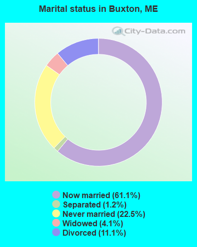
- Never married: 22.5%
- Now married: 61.1%
- Separated: 1.2%
- Widowed: 4.1%
- Divorced: 11.1%
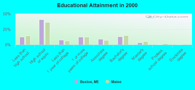
For population 25 years and over in Buxton:
- High school or higher: 87.2%
- Bachelor's degree or higher: 17.3%
- Graduate or professional degree: 4.2%
- Unemployed: 2.0%
- Mean travel time to work (commute): 29.7 minutes
| Here: | 9.3 |
| Maine average: | 11.2 |


Graphs represent county-level data. Detailed 2008 Election Results
Religion statistics for Buxton, ME (based on York County data)
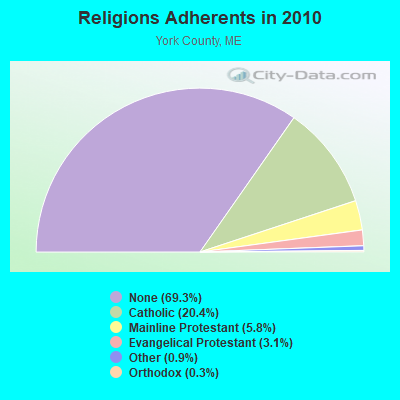

| Religion | Adherents | Congregations |
|---|---|---|
| Catholic | 40,283 | 16 |
| Mainline Protestant | 11,480 | 64 |
| Evangelical Protestant | 6,086 | 51 |
| Other | 1,847 | 18 |
| Orthodox | 625 | 3 |
| Black Protestant | 119 | 1 |
| None | 136,691 | - |
Food Environment Statistics:
| York County: | 2.24 / 10,000 pop. |
| State: | 2.80 / 10,000 pop. |
| Here: | 0.05 / 10,000 pop. |
| Maine: | 0.14 / 10,000 pop. |
| Here: | 2.09 / 10,000 pop. |
| Maine: | 2.20 / 10,000 pop. |
| York County: | 4.23 / 10,000 pop. |
| State: | 5.75 / 10,000 pop. |
| Here: | 12.53 / 10,000 pop. |
| Maine: | 11.02 / 10,000 pop. |
| York County: | 7.7% |
| Maine: | 8.2% |
| This county: | 24.0% |
| Maine: | 25.0% |
Businesses in Buxton, ME
- GNC: 1
- Rite Aid: 1
- U-Haul: 1
Strongest AM radio stations in Buxton:
- WMTW (870 AM; 10 kW; GORHAM, ME; Owner: RADIO PARTNERS OF MAINE, L.P.)
- WGAN (560 AM; 5 kW; PORTLAND, ME; Owner: SAGA COMMUNICATIONS OF NEW ENGLAND, LLC)
- WJAE (1440 AM; 5 kW; WESTBROOK, ME; Owner: ALTANTIC COAST RADIO, LLC)
- WZAN (970 AM; 5 kW; PORTLAND, ME; Owner: SAGA COMMUNICATIONS OF NEW ENGLAND, LLC)
- WLOB (1310 AM; 5 kW; PORTLAND, ME; Owner: ATLANTIC COAST RADIO, LLC)
- WGIN (930 AM; 10 kW; ROCHESTER, NH; Owner: CAPSTAR TX LIMITED PARTNERSHIP)
- WRKO (680 AM; 50 kW; BOSTON, MA; Owner: ENTERCOM BOSTON LICENSE, LLC)
- WIDE (1400 AM; 1 kW; BIDDEFORD, ME; Owner: SACO BAY COMMUNICATIONS GROUP INC)
- WEEI (850 AM; 50 kW; BOSTON, MA; Owner: ENTERCOM BOSTON LICENSE, LLC)
- WBZ (1030 AM; 50 kW; BOSTON, MA; Owner: INFINITY BROADCASTING OPERATIONS, INC.)
- WCRN (830 AM; 50 kW; WORCESTER, MA; Owner: CARTER BROADCASTING CORPORATION)
- WWZN (1510 AM; 50 kW; BOSTON, MA; Owner: ROSE CITY RADIO CORPORATION)
- WKOX (1200 AM; 50 kW; FRAMINGHAM, MA; Owner: CAPSTAR TX LIMITED PARTNERSHIP)
Strongest FM radio stations in Buxton:
- WMEA (90.1 FM; PORTLAND, ME; Owner: MAINE PUBLIC BROADCASTING CORPORATION)
- WBLM (102.9 FM; PORTLAND, ME; Owner: CITADEL BROADCASTING COMPANY)
- WCYY (94.3 FM; BIDDEFORD, ME; Owner: CITADEL BROADCASTING COMPANY)
- WMPG (90.9 FM; GORHAM, ME; Owner: UNIVERSITY OF MAINE SYSTEM)
- WRED (95.9 FM; SACO, ME; Owner: ATLANTIC COAST RADIO, LLC)
- WJBQ (97.9 FM; PORTLAND, ME; Owner: CITADEL BROADCASTING COMPANY)
- WPOR (101.9 FM; PORTLAND, ME; Owner: SAGA COMMUNICATIONS OF NEW ENGLAND, LLC)
- WPKQ (103.7 FM; NORTH CONWAY, NH; Owner: CITADEL BROADCASTING COMPANY)
- WHOM (94.9 FM; MT. WASHINGTON, NH; Owner: CITADEL BROADCASTING COMPANY)
- WBQW (106.3 FM; SCARBOROUGH, ME; Owner: MARINER BROADCASTING LIMITED PARTNER)
- WSCY (106.9 FM; MOULTONBOROUGH, NH; Owner: NORTHEAST COMMUNICATIONS CORPORATION)
- WMSJ (89.3 FM; FREEPORT, ME; Owner: DOWNEAST CHRISTIAN COMMUNICATIONS)
- WMTW-FM (106.7 FM; NORTH WINDHAM, ME; Owner: RADIO PARTNERS OF MAINE, L.P.)
- WTHT (107.5 FM; LEWISTON, ME; Owner: RADIO PARTNERS OF MAINE, L.P.)
- WMGX (93.1 FM; PORTLAND, ME; Owner: SAGA COMMUNICATIONS OF NEW ENGLAND, LLC)
- WPHX-FM (92.1 FM; SANFORD, ME; Owner: FNX BROADCASTING LLC)
- WSEW (88.5 FM; SANFORD, ME; Owner: WORD RADIO EDUCATIONAL FOUNDATION)
- WVFM (105.7 FM; CAMPTON, NH; Owner: DEVON BROADCASTING COMPANY, INC.)
- WMEK-FM (99.9 FM; AUBURN, ME; Owner: RADIO PARTNERS OF MAINE, L.P.)
- WQEZ (104.7 FM; KENNEBUNKPORT, ME; Owner: MARINER BROADCASTING L.P.)
TV broadcast stations around Buxton:
- WMTW-TV (Channel 8; POLAND SPRING, ME; Owner: WMTW BROADCAST GROUP, LLC)
- WMEA-TV (Channel 26; BIDDEFORD, ME; Owner: MAINE PUBLIC BROADCASTING CORP.)
- WCSH (Channel 6; PORTLAND, ME; Owner: PACIFIC AND SOUTHERN COMPANY, INC.)
- WGME-TV (Channel 13; PORTLAND, ME; Owner: WGME LICENSEE, LLC)
- WPXT (Channel 51; PORTLAND, ME; Owner: HMW, INC.)
- WPME (Channel 35; LEWISTON, ME; Owner: KB PRIME MEDIA LLC)
- W32CA (Channel 32; PORTLAND, ME; Owner: NATIONAL MINORITY T.V., INC.)
- W58CM (Channel 58; BANGOR, ME; Owner: MS COMMUNICATIONS, LLC)
- WLLB-LP (Channel 15; PORTLAND, ME; Owner: CARTER BROADCASTING CORPORATION)
- W57AP (Channel 57; FALMOUTH, ME; Owner: SHERWOOD H. CRAIG)
- National Bridge Inventory (NBI) Statistics
- 1Number of bridges
- 59ft / 18.5mTotal length
- 4,526Total average daily traffic
- 135Total average daily truck traffic
- 3,738Total future (year 2036) average daily traffic
FCC Registered Cell Phone Towers:
1 (See the full list of FCC Registered Cell Phone Towers in Buxton)FCC Registered Antenna Towers:
8 (See the full list of FCC Registered Antenna Towers)FCC Registered Broadcast Land Mobile Towers:
3- 9 Gillette Rd (Lat: 43.700778 Lon: -70.552611), Type: Bant, Structure height: 10.6 m, Overall height: 15 m, Call Sign: WQKQ284,
Assigned Frequencies: 153.170 MHz, Grant Date: 07/11/2019, Expiration Date: 08/10/2029, Certifier: David Piche, Registrant: Radio Communications Management, 158 Rand Rd, Portland, ME 04102, Phone: (207) 797-7503, Email:
- 94 Portland St (Lat: 43.613389 Lon: -70.543000), Type: Bant, Structure height: 6.1 m, Overall height: 9.1 m, Call Sign: WSAI284,
Assigned Frequencies: 153.845 MHz, Grant Date: 01/18/2024, Expiration Date: 01/18/2034, Certifier: Kevin Collins, Registrant: Radio Communications Management, 158 Rand Rd, Portland, ME 04103, Phone: (207) 797-7503, Fax: (949) 348-8514, Email:
- 94 Portland St (Lat: 43.613389 Lon: -70.543000), Type: Bant, Structure height: 6.1 m, Overall height: 9.1 m, Call Sign: WSCB705,
Assigned Frequencies: 154.235 MHz, Grant Date: 03/26/2024, Expiration Date: 03/26/2034, Certifier: Kevin Collins, Registrant: Radio Communications Management, 158 Rand Rd, Portland, ME 04103, Phone: (207) 797-7503, Fax: (949) 348-8514, Email:
FCC Registered Microwave Towers:
2- BUXTON, 64 Deering Rd (Lat: 43.630500 Lon: -70.478417), Type: Mtower, Structure height: 57.9 m, Overall height: 60.4 m, Call Sign: WQSY577,
Assigned Frequencies: 17915.0 MHz, 17965.0 MHz, 17965.0 MHz, Grant Date: 11/07/2023, Expiration Date: 12/10/2033, Certifier: John E Monday, Registrant: At&t Services, Inc., 208 S Akard St, 20f, Dallas, TX 75202, Phone: (855) 699-7073, Email:
- STATION, Along Skip Rd 1.2 Miles Nw Of (Lat: 43.662833 Lon: -70.553639), Structure height: 30.5 m, Overall height: 79.2 m, Call Sign: WCE327,
Assigned Frequencies: 1905.00 MHz, Grant Date: 05/06/1998, Expiration Date: 07/30/2008, Cancellation Date: 11/04/2004, Phone: (202) 331-9495
FCC Registered Amateur Radio Licenses:
50 (See the full list of FCC Registered Amateur Radio Licenses in Buxton)FAA Registered Aircraft:
6- Aircraft: AERONCA 7DC (Category: Land, Seats: 2, Weight: Up to 12,499 Pounds, Speed: 90 mph), Engine: CONT MOTOR C85 SERIES (85 HP) (Reciprocating)
N-Number: 2052E, N2052E, N-2052E, Serial Number: 7AC-5622, Airworthiness Date: 01/15/1957, Certificate Issue Date: 10/15/2015
Registrant (Individual): David S Harmon, 90 Back Nippen Rd, Buxton, ME 04093 - Aircraft: CESSNA 172H (Category: Land, Seats: 4, Weight: Up to 12,499 Pounds, Speed: 105 mph), Engine: CONT MOTOR 0-300 SER (145 HP) (Reciprocating)
N-Number: 3298L, N3298L, N-3298L, Serial Number: 17256198, Year manufactured: 1967, Airworthiness Date: 05/17/1967, Certificate Issue Date: 12/03/1998
Registrant (Individual): Edward E Thompson, 30 Ferncroft Rd, Buxton, ME 04093 - Aircraft: BELLANCA 7GCBC (Category: Land, Seats: 2, Weight: Up to 12,499 Pounds, Speed: 90 mph), Engine: LYCOMING 0-320 SERIES (180 HP) (Reciprocating)
N-Number: 4135Y, N4135Y, N-4135Y, Serial Number: 953-76, Year manufactured: 1976, Airworthiness Date: 10/21/1976, Certificate Issue Date: 12/05/2019
Registrant (Individual): Jack L Chase, 452 Webster Rd, Buxton, ME 04093 - Aircraft: MACGOWN RICHARD HAROLD KITFOX MODEL 1 (Category: Land, Seats: 2, Weight: Up to 12,499 Pounds), Engine: BOMBARDIER ROTAX (ALL) (Reciprocating)
N-Number: 89KF, N89KF, N-89KF, Serial Number: 124, Airworthiness Date: 07/15/1993, Certificate Issue Date: 09/18/2019
Registrant (Individual): Daniel E Desvergnes, 273 River Rd, Buxton, ME 04093 - Aircraft: TAYLORCRAFT BC12-D (Category: Land, Seats: 2, Weight: Up to 12,499 Pounds, Speed: 78 mph), Engine: CONT MOTOR A&C65 SERIES (65 HP) (Reciprocating)
N-Number: 95176, N95176, N-95176, Serial Number: 9576, Year manufactured: 1946, Airworthiness Date: 06/08/1956, Certificate Issue Date: 01/24/2013
Registrant (Individual): Barry S Brewster, 106 Callahan Rd, Buxton, ME 04093 - Aircraft: THOMPSON EDWARD LM-5X-W (Category: Land, Seats: 2, Weight: Up to 12,499 Pounds), Engine: VOLKSWAGEN 2276CC (180 HP) (Reciprocating)
N-Number: 970CE, N970CE, N-970CE, Serial Number: 1001, Year manufactured: 2019, Airworthiness Date: 10/17/2019, Certificate Issue Date: 03/14/2017
Registrant (Individual): Edward Thompson, 30 Ferncroft Rd, Buxton, ME 04093
2003 - 2018 National Fire Incident Reporting System (NFIRS) incidents
- Fire incident types reported to NFIRS in Buxton, ME
- 13042.3%Structure Fires
- 11236.5%Outside Fires
- 3511.4%Mobile Property/Vehicle Fires
- 309.8%Other
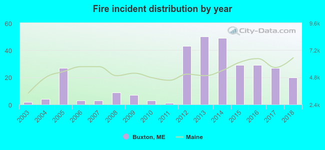 According to the data from the years 2003 - 2018 the average number of fire incidents per year is 19. The highest number of fires - 50 took place in 2013, and the least - 1 in 2011. The data has an increasing trend.
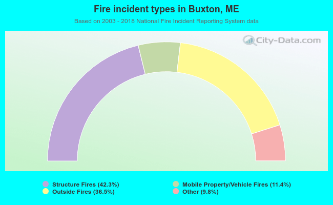 When looking into fire subcategories, the most reports belonged to: Structure Fires (42.3%), and Outside Fires (36.5%).
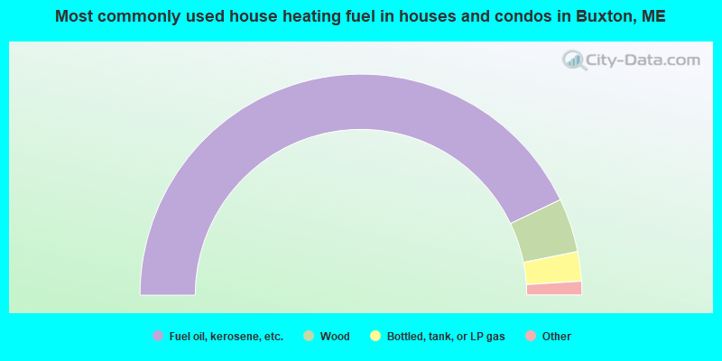
- 85.8%Fuel oil, kerosene, etc.
- 7.9%Wood
- 4.3%Bottled, tank, or LP gas
- 1.6%Electricity
- 0.3%Other fuel
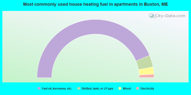
- 87.5%Fuel oil, kerosene, etc.
- 6.6%Bottled, tank, or LP gas
- 4.0%Wood
- 1.9%Electricity
Buxton compared to Maine state average:
- Unemployed percentage significantly below state average.
- Black race population percentage below state average.
- Hispanic race population percentage below state average.
- Foreign-born population percentage below state average.
- Renting percentage below state average.
- Length of stay since moving in significantly above state average.
- Number of rooms per house significantly below state average.
- House age significantly below state average.
- Percentage of population with a bachelor's degree or higher below state average.
Buxton on our top lists:
- #10 on the list of "Top 101 cities with largest percentage of males in industries: alcoholic beverages merchant wholesalers (population 5,000+)"
- #14 on the list of "Top 101 cities with largest percentage of males in industries: hardware, plumbing and heating equipment, and supplies merchant wholesalers (population 5,000+)"
- #18 on the list of "Top 101 cities with largest percentage of females in occupations: counselors, social workers, and other community and social service specialists (population 5,000+)"
- #20 on the list of "Top 101 cities with largest percentage of males in occupations: pipelayers, plumbers, pipefitters, and steamfitters (population 5,000+)"
- #22 on the list of "Top 101 cities with largest percentage of males in occupations: material recording, scheduling, dispatching, and distributing workers (population 5,000+)"
- #25 on the list of "Top 101 cities with largest percentage of males in industries: petroleum and petroleum products merchant wholesalers (population 5,000+)"
- #26 on the list of "Top 101 cities with largest percentage of females in industries: wood products (population 5,000+)"
- #27 on the list of "Top 101 cities with largest percentage of males in industries: fuel dealers (population 5,000+)"
- #30 on the list of "Top 101 cities with largest percentage of females in industries: leather and allied products (population 5,000+)"
- #35 on the list of "Top 101 cities with largest percentage of females in occupations: construction trades workers except carpenters, electricians, painters, plumbers, and construction laborers (population 5,000+)"
- #41 on the list of "Top 101 cities with largest percentage of females in industries: other direct selling establishments (population 5,000+)"
- #43 on the list of "Top 101 cities with largest percentage of males in industries: motor vehicle and parts dealers (population 5,000+)"
- #45 on the list of "Top 101 cities with largest percentage of males in industries: water transportation (population 5,000+)"
- #46 on the list of "Top 101 cities with largest percentage of females in occupations: information and record clerks except customer service representatives (population 5,000+)"
- #47 on the list of "Top 101 cities with largest percentage of males in occupations: other healthcare support occupations (population 5,000+)"
- #47 on the list of "Top 101 cities with largest percentage of females in industries: personal and laundry services (population 5,000+)"
- #60 on the list of "Top 101 cities with largest percentage of males in industries: leather and allied products (population 5,000+)"
- #66 on the list of "Top 101 cities with largest percentage of males in industries: groceries and related products merchant wholesalers (population 5,000+)"
- #68 on the list of "Top 101 cities with largest percentage of males in industries: building material and garden equipment and supplies dealers (population 5,000+)"
- #69 on the list of "Top 101 cities with largest percentage of males in industries: recyclable material merchant wholesalers (population 5,000+)"
- #21 on the list of "Top 101 counties with the highest percentage of residents that smoked 100+ cigarettes in their lives"
- #35 on the list of "Top 101 counties with the lowest number of births per 1000 residents 2007-2013"
- #70 on the list of "Top 101 counties with the highest percentage of residents that keep firearms around their homes"
- #77 on the list of "Top 101 counties with the best general health status score of residents (1-5), 3 years of data"

|
|
Total of 10 patent applications in 2008-2024.