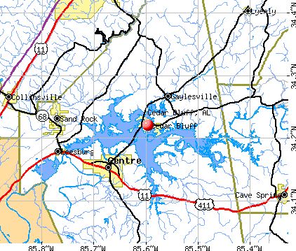
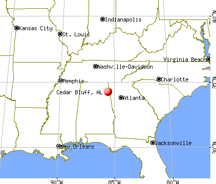
Cedar Bluff, Alabama
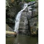
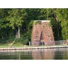
Cedar Bluff: Yellow Creek Falls which drops 100 feet into Lake Weiss, Alabama

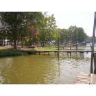
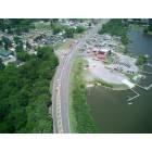
Cedar Bluff: Sunrise over the bridge that connects Cedar Bluff to Centre, Alabama at Lake Weiss
Cedar Bluff: Riverside Campground & Motel
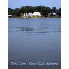
Cedar Bluff: Beautiful Weiss Lake from the banks of Cedar Bluff, Alabama
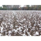
Cedar Bluff: cotton pickin' time in 'bama
Cedar Bluff
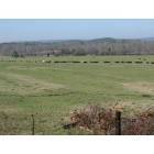
Cedar Bluff: Feeding Cows close to Gaylesville Alabama
Cedar Bluff
Cedar Bluff
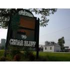
Cedar Bluff: Welcome to Cedar Bluff, Alabama
Cedar Bluff: Weiss Mart Marina & Weiss Lake Motel-256-779-3474
Cedar Bluff: Cedar Bluff Merchandise Outlet
- add
your
Submit your own pictures of this town and show them to the world
- OSM Map
- General Map
- Google Map
- MSN Map
Population change since 2000: +27.7%
| Males: 899 | |
| Females: 975 |
| Median resident age: | 45.6 years |
| Alabama median age: | 39.6 years |
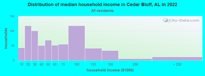
| Cedar Bluff: | $45,911 |
| AL: | $59,674 |
Estimated per capita income in 2022: $24,650 (it was $16,864 in 2000)
Cedar Bluff town income, earnings, and wages data
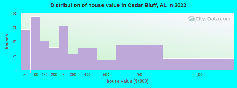
Estimated median house or condo value in 2022: $177,831 (it was $62,400 in 2000)
| Cedar Bluff: | $177,831 |
| AL: | $200,900 |
Mean prices in 2022: all housing units: $219,473; detached houses: $259,612; in 5-or-more-unit structures: $274,690; mobile homes: $81,134
Median gross rent in 2022: $548.
(28.2% for White Non-Hispanic residents, 55.4% for Black residents, 55.6% for Hispanic or Latino residents, 100.0% for American Indian residents, 8.1% for two or more races residents)
Detailed information about poverty and poor residents in Cedar Bluff, AL

Compare current foreclosures near Cedar Bluff, AL:
| Photo | Address | Area | Beds / Baths | Price | Details |
|---|---|---|---|---|---|

|
#1
Oak Tree Ln
Cedar Bluff, AL 35959
|
2,556 sq. feet
|
- baths - beds |
show details | |

|
#2
Oak Tree Ln
Cedar Bluff, AL 35959
|
- sq. feet
|
- baths - beds |
show details | |

|
#3
County Road 75
Cedar Bluff, AL 35959
|
- sq. feet
|
- baths - beds |
show details | |

|
#4
Al Highway 9 N
Cedar Bluff, AL 35959
|
1,860 sq. feet
|
- baths - beds |
show details | |

|
#5
Cherokee Dr
Cedar Bluff, AL 35959
|
3,169 sq. feet
|
- baths - beds |
show details | |

|
#6
Summer Place Rd
Cedar Bluff, AL 35959
|
1,425 sq. feet
|
- baths - beds |
show details | |

|
#7
Sewell Ferry Rd
Cedar Bluff, AL 35959
|
1,680 sq. feet
|
- baths - beds |
show details | |

|
#8
Cornwall Dr
Cedar Bluff, AL 35959
|
1,612 sq. feet
|
- baths - beds |
show details | |

|
#9
County Road 48
Cedar Bluff, AL 35959
|
- sq. feet
|
- baths - beds |
show details | |

|
#10
County Road 48
Cedar Bluff, AL 35959
|
1,806 sq. feet
|
- baths - beds |
show details |
| Photo | Address | Area | Beds / Baths | Price | Details |
|---|---|---|---|---|---|

|
#11
Al Hwy 9 S
Piedmont, AL 36272
|
3,200 sq. feet
|
- baths 4 beds |
$329,900
|
show details |

|
#12
Appleton St
Centre, AL 35960
|
2,075 sq. feet
|
2 baths 3 beds |
show details | |

|
#13
Black Creek Rd
Collinsville, AL 35961
|
2,329 sq. feet
|
3 baths 3 beds |
show details | |

|
#14
Turner Ave SE
Fort Payne, AL 35967
|
1,027 sq. feet
|
1 baths 2 beds |
show details | |

|
#15
County Road 69
Centre, AL 35960
|
1,805 sq. feet
|
2 baths 3 beds |
show details | |

|
#16
Terrace Ave
Collinsville, AL 35961
|
1,140 sq. feet
|
1 baths - beds |
show details | |

|
#17
Big Texas Valley Rd NW
Rome, GA 30165
|
1,458 sq. feet
|
2 baths - beds |
show details | |

|
#18
Beeson Gap Rd NE
Fort Payne, AL 35967
|
1,424 sq. feet
|
1 baths - beds |
show details | |

|
#19
Worsham Rd
Lyerly, GA 30730
|
2,938 sq. feet
|
1 baths - beds |
show details | |

|
#20
Williams St
Lyerly, GA 30730
|
1,640 sq. feet
|
1 baths - beds |
show details |
| Photo | Address | Area | Beds / Baths | Price | Details |
|---|---|---|---|---|---|

|
#21
County Road 79
Centre, AL 35960
|
1,680 sq. feet
|
- baths - beds |
show details | |

|
#22
County Road 657
Gaylesville, AL 35973
|
1,728 sq. feet
|
- baths - beds |
show details | |

|
#23
Pineview Ct
Centre, AL 35960
|
1,456 sq. feet
|
- baths - beds |
show details | |

|
#24
County Road 31
Piedmont, AL 36272
|
- sq. feet
|
- baths - beds |
show details | |

|
#25
Gault Ave S
Fort Payne, AL 35967
|
- sq. feet
|
- baths - beds |
show details | |

|
#26
County Road 4
Piedmont, AL 36272
|
- sq. feet
|
- baths - beds |
show details | |

|
#27
Gregory Dr
Collinsville, AL 35961
|
- sq. feet
|
- baths - beds |
show details | |

|
#28
County Road 414
Centre, AL 35960
|
1,841 sq. feet
|
- baths - beds |
show details | |

|
#29
Plains Ave SW
Fort Payne, AL 35967
|
- sq. feet
|
- baths - beds |
show details | |

|
#30
County Road 31
Piedmont, AL 36272
|
2,368 sq. feet
|
- baths - beds |
show details |
| Photo | Address | Area | Beds / Baths | Price | Details |
|---|---|---|---|---|---|

|
#31
Oreburg Rd NW
Rome, GA 30165
|
- sq. feet
|
1 baths - beds |
show details | |

|
#32
County Road 69
Centre, AL 35960
|
- sq. feet
|
- baths - beds |
show details | |

|
#33
Gilley Rd
Gadsden, AL 35903
|
- sq. feet
|
- baths - beds |
show details | |

|
#34
County Road 470
Centre, AL 35960
|
- sq. feet
|
- baths - beds |
show details | |

|
#35
Project Ln
Collinsville, AL 35961
|
- sq. feet
|
- baths - beds |
show details | |

|
#36
Spout Springs Rd SW
Rome, GA 30161
|
- sq. feet
|
1 baths - beds |
show details | |

|
#37
Fosters Mill Rd SW
Cave Spring, GA 30124
|
- sq. feet
|
- baths - beds |
show details | |

|
#38
Fosters Mill Rd SW
Rome, GA 30161
|
- sq. feet
|
1 baths - beds |
show details | |

|
#39
Collins Rd
Gadsden, AL 35903
|
- sq. feet
|
- baths - beds |
show details | |

|
#40
Pineview Ct
Centre, AL 35960
|
- sq. feet
|
- baths - beds |
show details |
| Photo | Address | Area | Beds / Baths | Price | Details |
|---|---|---|---|---|---|

|
#41
Jordan Dr
Centre, AL 35960
|
3,453 sq. feet
|
- baths - beds |
show details | |

|
#42
Lake Park Dr NW
Rome, GA 30165
|
- sq. feet
|
1 baths - beds |
show details | |

|
#43
Wallace Ave NE
Fort Payne, AL 35967
|
- sq. feet
|
- baths - beds |
show details | |

|
#44
County Road 8
Piedmont, AL 36272
|
- sq. feet
|
- baths - beds |
show details | |

|
#45
County Road 64
Gaylesville, AL 35973
|
- sq. feet
|
- baths - beds |
show details | |

|
#46
5th St NE
Fort Payne, AL 35967
|
- sq. feet
|
- baths - beds |
show details | |

|
#47
Fouche Gap Rd NW
Rome, GA 30165
|
- sq. feet
|
1 baths - beds |
show details | |

|
#48
Alabama Hwy NW Apt C4
Rome, GA 30165
|
- sq. feet
|
- baths - beds |
show details | |

|
#49
Starling Mill Rd
Lyerly, GA 30730
|
- sq. feet
|
- baths - beds |
show details | |

|
Check over 1 million property listings on Foreclosure.com!
|
browse all offers | |||


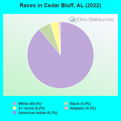
- 1,50289.0%White alone
- 995.9%Black alone
- 714.2%Two or more races
- 90.5%Hispanic
- 50.3%American Indian alone
According to our research of Alabama and other state lists, there were 19 registered sex offenders living in Cedar Bluff, Alabama as of April 25, 2024.
The ratio of all residents to sex offenders in Cedar Bluff is 105 to 1.
Type |
2009 |
2010 |
2011 |
2012 |
2013 |
2014 |
2015 |
2016 |
2017 |
2018 |
2019 |
2020 |
2021 |
2022 |
|---|---|---|---|---|---|---|---|---|---|---|---|---|---|---|
| Murders (per 100,000) | 0 (0.0) | 0 (0.0) | 1 (54.7) | 0 (0.0) | 0 (0.0) | 0 (0.0) | 0 (0.0) | 1 (55.6) | 0 (0.0) | 0 (0.0) | 0 (0.0) | 0 (0.0) | 0 (0.0) | 0 (0.0) |
| Rapes (per 100,000) | 1 (59.8) | 0 (0.0) | 0 (0.0) | 1 (54.6) | 1 (55.1) | 0 (0.0) | 1 (55.1) | 1 (55.6) | 0 (0.0) | 0 (0.0) | 0 (0.0) | 0 (0.0) | 0 (0.0) | 0 (0.0) |
| Robberies (per 100,000) | 0 (0.0) | 1 (54.9) | 2 (109.3) | 0 (0.0) | 1 (55.1) | 0 (0.0) | 0 (0.0) | 0 (0.0) | 0 (0.0) | 0 (0.0) | 0 (0.0) | 0 (0.0) | 0 (0.0) | 0 (0.0) |
| Assaults (per 100,000) | 21 (1,256) | 10 (549.5) | 23 (1,258) | 21 (1,146) | 18 (992.3) | 12 (654.0) | 9 (496.1) | 1 (55.6) | 2 (112.0) | 1 (55.7) | 1 (55.0) | 4 (219.4) | 3 (163.9) | 5 (266.1) |
| Burglaries (per 100,000) | 23 (1,376) | 21 (1,154) | 89 (4,866) | 64 (3,493) | 63 (3,473) | 30 (1,635) | 4 (220.5) | 4 (222.5) | 13 (728.3) | 3 (167.2) | 2 (110.1) | 7 (384.0) | 7 (382.5) | 6 (319.3) |
| Thefts (per 100,000) | 45 (2,691) | 93 (5,110) | 150 (8,201) | 110 (6,004) | 122 (6,725) | 97 (5,286) | 46 (2,536) | 16 (889.9) | 27 (1,513) | 16 (891.9) | 6 (330.2) | 26 (1,426) | 31 (1,694) | 29 (1,543) |
| Auto thefts (per 100,000) | 2 (119.6) | 21 (1,154) | 15 (820.1) | 11 (600.4) | 6 (330.8) | 8 (436.0) | 3 (165.4) | 3 (166.9) | 5 (280.1) | 1 (55.7) | 2 (110.1) | 3 (164.6) | 6 (327.9) | 6 (319.3) |
| Arson (per 100,000) | 0 (0.0) | 0 (0.0) | 0 (0.0) | 1 (54.6) | 1 (55.1) | 3 (163.5) | 2 (110.3) | 3 (166.9) | 0 (0.0) | 2 (111.5) | 0 (0.0) | 0 (0.0) | 0 (0.0) | 0 (0.0) |
| City-Data.com crime index | 512.6 | 503.8 | 1127.9 | 805.7 | 797.7 | 491.6 | 273.4 | 231.4 | 156.3 | 63.0 | 40.7 | 141.0 | 153.6 | 162.9 |
The City-Data.com crime index weighs serious crimes and violent crimes more heavily. Higher means more crime, U.S. average is 246.1. It adjusts for the number of visitors and daily workers commuting into cities.
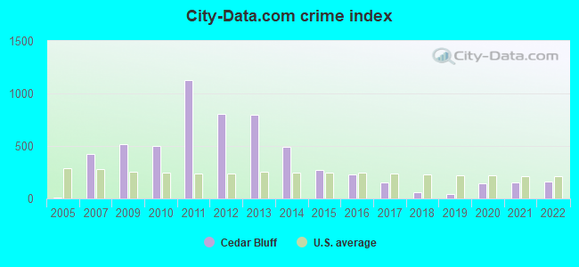
Crime rate in Cedar Bluff detailed stats: murders, rapes, robberies, assaults, burglaries, thefts, arson
Full-time law enforcement employees in 2021, including police officers: 5 (5 officers - 5 male; 0 female).
| Officers per 1,000 residents here: | 2.73 |
| Alabama average: | 2.40 |
 Recent articles from our blog. Our writers, many of them Ph.D. graduates or candidates, create easy-to-read articles on a wide variety of topics.

 | Why doesn't Huntsville meet any interstate highway directly? (53 replies) |
| looking for a long term rental (0 replies) |
| Thinking of NE Ala to retire (52 replies) |
| Cherokee County - Weiss Lake - Nearest Catholic Church (1 reply) |
| Possibly Retiring to Scottsboro - Advice Please (6 replies) |
| Retire to which north Alabama city? (6 replies) |
Latest news from Cedar Bluff, AL collected exclusively by city-data.com from local newspapers, TV, and radio stations
Ancestries: Irish (19.2%), American (16.2%), English (15.1%), German (3.0%), Austrian (2.5%), Dutch (1.4%).
Current Local Time: CST time zone
Elevation: 602 feet
Land area: 3.97 square miles.
Population density: 472 people per square mile (low).
14 residents are foreign born
| This town: | 0.8% |
| Alabama: | 3.5% |
Median real estate property taxes paid for housing units with mortgages in 2022: $1,093 (0.4%)
Median real estate property taxes paid for housing units with no mortgage in 2022: $498 (0.4%)
Nearest city with pop. 50,000+: Chattanooga, TN  (60.0 miles , pop. 155,554).
Nearest city with pop. 200,000+: Atlanta, GA (75.5 miles , pop. 416,474).
Nearest city with pop. 1,000,000+: Chicago, IL (539.1 miles , pop. 2,896,016).
Nearest cities:
), ), )Latitude: 34.22 N, Longitude: 85.60 W
Area code: 256
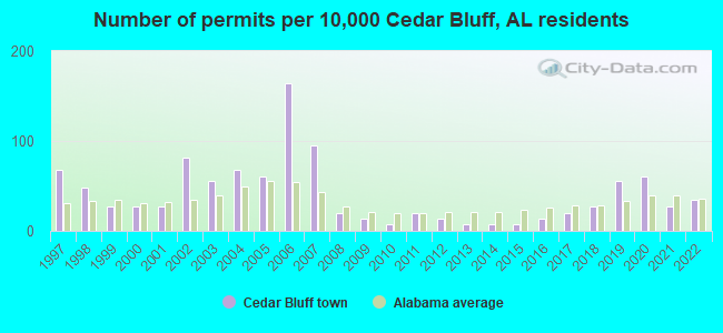
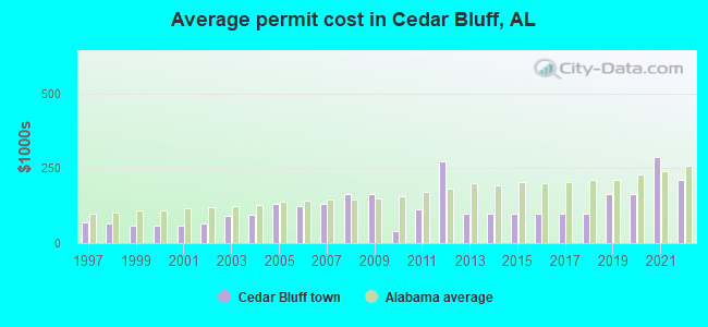
Single-family new house construction building permits:
- 2022: 5 buildings, average cost: $212,300
- 2021: 4 buildings, average cost: $287,000
- 2020: 9 buildings, average cost: $162,500
- 2019: 8 buildings, average cost: $162,500
- 2018: 4 buildings, average cost: $100,000
- 2017: 3 buildings, average cost: $100,000
- 2016: 2 buildings, average cost: $100,000
- 2015: 1 building, cost: $100,000
- 2014: 1 building, cost: $100,000
- 2013: 1 building, cost: $100,000
- 2012: 2 buildings, average cost: $275,000
- 2011: 3 buildings, average cost: $112,900
- 2010: 1 building, cost: $40,000
- 2009: 2 buildings, average cost: $165,000
- 2008: 3 buildings, average cost: $165,000
- 2007: 14 buildings, average cost: $132,000
- 2006: 24 buildings, average cost: $123,200
- 2005: 9 buildings, average cost: $130,200
- 2004: 10 buildings, average cost: $95,500
- 2003: 8 buildings, average cost: $89,600
- 2002: 12 buildings, average cost: $66,400
- 2001: 4 buildings, average cost: $58,300
- 2000: 4 buildings, average cost: $58,300
- 1999: 4 buildings, average cost: $58,300
- 1998: 7 buildings, average cost: $64,300
- 1997: 10 buildings, average cost: $68,700
| Here: | 2.6% |
| Alabama: | 2.6% |
- Educational services (9.1%)
- Construction (8.7%)
- Health care (7.6%)
- Textile mills & textile products (7.4%)
- Apparel (6.9%)
- Food (4.5%)
- Accommodation & food services (4.2%)
- Construction (14.2%)
- Textile mills & textile products (9.4%)
- Metal & metal products (5.7%)
- Administrative & support & waste management services (5.3%)
- Paper (5.3%)
- Educational services (5.0%)
- Utilities (4.4%)
- Educational services (13.7%)
- Health care (13.7%)
- Apparel (13.4%)
- Accommodation & food services (8.3%)
- Finance & insurance (7.2%)
- Food (6.9%)
- Textile mills & textile products (5.1%)
- Other production occupations, including supervisors (10.1%)
- Textile, apparel, and furnishings workers (8.1%)
- Building and grounds cleaning and maintenance occupations (5.9%)
- Metal workers and plastic workers (5.0%)
- Laborers and material movers, hand (5.0%)
- Preschool, kindergarten, elementary, and middle school teachers (4.9%)
- Other office and administrative support workers, including supervisors (4.5%)
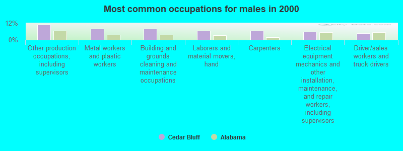
- Other production occupations, including supervisors (11.0%)
- Metal workers and plastic workers (8.2%)
- Building and grounds cleaning and maintenance occupations (7.9%)
- Laborers and material movers, hand (6.6%)
- Carpenters (6.6%)
- Electrical equipment mechanics and other installation, maintenance, and repair workers, including supervisors (5.7%)
- Driver/sales workers and truck drivers (4.7%)
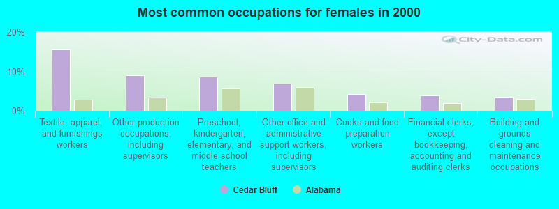
- Textile, apparel, and furnishings workers (15.5%)
- Other production occupations, including supervisors (9.0%)
- Preschool, kindergarten, elementary, and middle school teachers (8.7%)
- Other office and administrative support workers, including supervisors (6.9%)
- Cooks and food preparation workers (4.3%)
- Financial clerks, except bookkeeping, accounting and auditing clerks (4.0%)
- Building and grounds cleaning and maintenance occupations (3.6%)
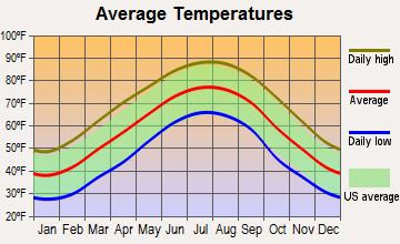
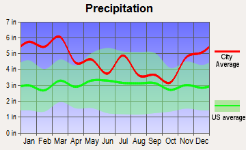
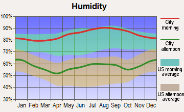
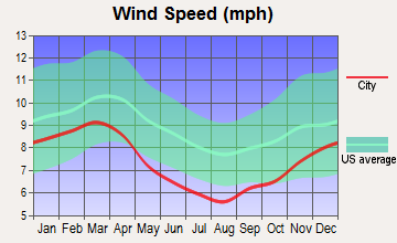
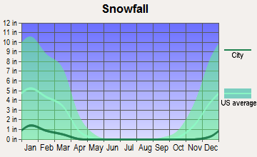
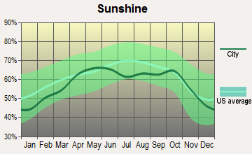
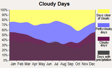
Average climate in Cedar Bluff, Alabama
Based on data reported by over 4,000 weather stations
|
|


(lower is better)
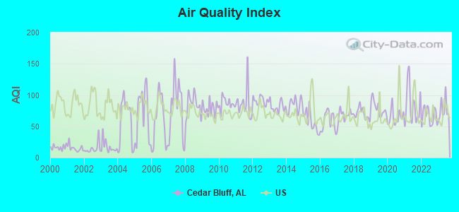
Air Quality Index (AQI) level in 2023 was 76.9. This is about average.
| City: | 76.9 |
| U.S.: | 72.6 |
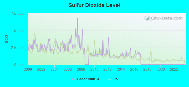
Sulfur Dioxide (SO2) [ppb] level in 2016 was 1.61. This is about average. Closest monitor was 15.8 miles away from the city center.
| City: | 1.61 |
| U.S.: | 1.51 |
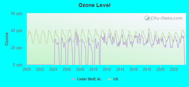
Ozone [ppb] level in 2023 was 30.7. This is about average. Closest monitor was 20.6 miles away from the city center.
| City: | 30.7 |
| U.S.: | 33.3 |
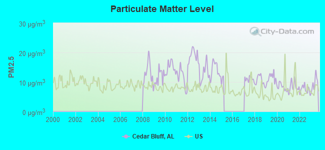
Particulate Matter (PM2.5) [µg/m3] level in 2023 was 9.52. This is about average. Closest monitor was 15.8 miles away from the city center.
| City: | 9.52 |
| U.S.: | 8.11 |
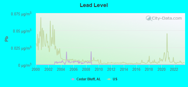
Lead (Pb) [µg/m3] level in 2008 was 0.00488. This is significantly better than average. Closest monitor was 24.0 miles away from the city center.
| City: | 0.00488 |
| U.S.: | 0.00931 |
Tornado activity:
Cedar Bluff-area historical tornado activity is slightly above Alabama state average. It is 120% greater than the overall U.S. average.
On 3/27/1994, a category F4 (max. wind speeds 207-260 mph) tornado 17.1 miles away from the Cedar Bluff town center killed 22 people and injured 150 people and caused between $5,000,000 and $50,000,000 in damages.
On 5/19/1973, a category F4 tornado 19.4 miles away from the town center injured 19 people and caused between $500,000 and $5,000,000 in damages.
Earthquake activity:
Cedar Bluff-area historical earthquake activity is significantly above Alabama state average. It is 107% greater than the overall U.S. average.On 4/29/2003 at 08:59:39, a magnitude 4.9 (4.4 MB, 4.6 MW, 4.9 LG, Class: Light, Intensity: IV - V) earthquake occurred 19.0 miles away from Cedar Bluff center
On 4/29/2003 at 08:59:39, a magnitude 4.6 (4.6 MW, Depth: 12.3 mi) earthquake occurred 19.0 miles away from the city center
On 1/18/1999 at 07:00:53, a magnitude 4.8 (4.8 MB, 4.0 LG, Depth: 0.6 mi) earthquake occurred 110.8 miles away from Cedar Bluff center
On 8/2/1974 at 08:52:09, a magnitude 4.9 (4.3 MB, 4.9 LG) earthquake occurred 179.7 miles away from the city center
On 11/30/1973 at 07:48:41, a magnitude 4.7 (4.7 MB, 4.6 ML) earthquake occurred 143.1 miles away from the city center
On 12/12/2018 at 09:14:43, a magnitude 4.4 (4.4 MW, Depth: 4.9 mi) earthquake occurred 108.0 miles away from Cedar Bluff center
Magnitude types: regional Lg-wave magnitude (LG), body-wave magnitude (MB), local magnitude (ML), moment magnitude (MW)
Natural disasters:
The number of natural disasters in Cherokee County (21) is greater than the US average (15).Major Disasters (Presidential) Declared: 12
Emergencies Declared: 5
Causes of natural disasters: Tornadoes: 11, Storms: 9, Floods: 6, Hurricanes: 5, Winds: 4, Winter Storms: 2, Drought: 1, Fire: 1, Snowfall: 1, Other: 1 (Note: some incidents may be assigned to more than one category).
Hospitals and medical centers near Cedar Bluff:
- CHEROKEE COMMUNITY HOSPICE (Hospital, about 6 miles away; CENTRE, AL)
- CHEROKEE MEDICAL CENTER Acute Care Hospitals (about 6 miles away; CENTRE, AL)
- CHEROKEE COUNTY HEALTH AND REHABILITATION CENTER (Nursing Home, about 6 miles away; CENTRE, AL)
- CHEROKEE HOME HEALTH (Home Health Center, about 8 miles away; CENTRE, AL)
- COLLINSVILLE HEALTHCARE AND REHAB (Nursing Home, about 16 miles away; COLLINSVILLE, AL)
Airports located in Cedar Bluff:
- Flying M Ranch Airport (AL32) (Runways: 1)
Colleges/universities with over 2000 students nearest to Cedar Bluff:
- Georgia Highlands College (about 23 miles; Rome, GA; Full-time enrollment: 4,071)
- Berry College (about 24 miles; Mount Berry, GA; FT enrollment: 2,102)
- Georgia Northwestern Technical College (about 25 miles; Rome, GA; FT enrollment: 4,629)
- Gadsden State Community College (about 28 miles; Gadsden, AL; FT enrollment: 4,650)
- Northeast Alabama Community College (about 29 miles; Rainsville, AL; FT enrollment: 2,409)
- Jacksonville State University (about 30 miles; Jacksonville, AL; FT enrollment: 7,566)
- Snead State Community College (about 33 miles; Boaz, AL; FT enrollment: 2,023)
Public high school in Cedar Bluff:
- CEDAR BLUFF HIGH SCH (Students: 597, Location: 3655 OLD HIGHWAY 9, Grades: KG-12)
Points of interest:
Notable location: Cedar Bluff Volunteer Fire Department (A). Display/hide its location on the map
Church in Cedar Bluff: Enon Grove Baptist Church (A). Display/hide its location on the map
Cemetery: Cedar Bluff Cemetery (1). Display/hide its location on the map
Park in Cedar Bluff: Cedar Bluff Park (1). Display/hide its location on the map
Hotels: Cedar Bluff Motel (3775 Al Highway 9), J R'S Marina & Motel (1780 County Road 102), Weiss Lake Motel (3500 Al Highway 9), Riverside Motel & RV Park (1210 County Road 131).
Drinking water stations with addresses in Cedar Bluff and their reported violations in the past:
CEDAR BLUFF UTILITIES BOARD (Population served: 3,858, Purch surface water):Past monitoring violations:
- Follow-up Or Routine LCR Tap M/R - In OCT-11-2005, Contaminant: Lead and Copper Rule. Follow-up actions: St Compliance achieved (JAN-03-2008)
| This town: | 2.4 people |
| Alabama: | 2.5 people |
| This town: | 68.0% |
| Whole state: | 67.8% |
| This town: | 6.0% |
| Whole state: | 4.7% |
Likely homosexual households (counted as self-reported same-sex unmarried-partner households)
- Lesbian couples: 0.3% of all households
- Gay men: 0.1% of all households
Banks with branches in Cedar Bluff (2011 data):
- Union State Bank: Cedar Bluff Main Branch at Highway 68 And Pine Street, branch established on 1982/11/04. Info updated 2011/02/24: Bank assets: $274.5 mil, Deposits: $250.5 mil, headquarters in Pell City, AL, negative income in the last year, Commercial Lending Specialization, 15 total offices, Holding Company: Union Bancshares, Inc.
- Generations Bank: Cedar Bluff Branch at 4971 Hwy 68, branch established on 2008/10/06. Info updated 2011/02/24: Bank assets: $64.1 mil, Deposits: $56.4 mil, headquarters in Centre, AL, positive income, Commercial Lending Specialization, 3 total offices, Holding Company: Altrust Financial Services, Inc.
For population 15 years and over in Cedar Bluff:
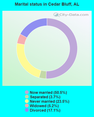
- Never married: 23.5%
- Now married: 50.5%
- Separated: 3.7%
- Widowed: 5.2%
- Divorced: 17.1%
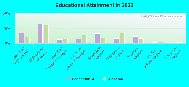
For population 25 years and over in Cedar Bluff:
- High school or higher: 80.8%
- Bachelor's degree or higher: 19.8%
- Graduate or professional degree: 12.3%
- Unemployed: 7.2%
- Mean travel time to work (commute): 34.6 minutes
| Here: | 12.9 |
| Alabama average: | 11.5 |
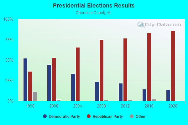
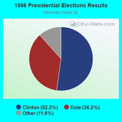

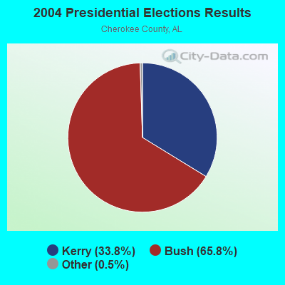
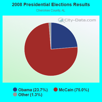
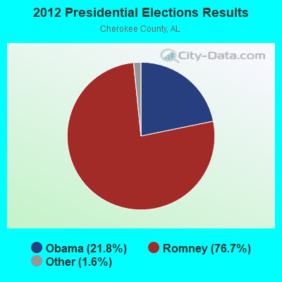
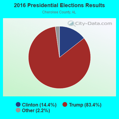

Graphs represent county-level data. Detailed 2008 Election Results
Religion statistics for Cedar Bluff, AL (based on Cherokee County data)
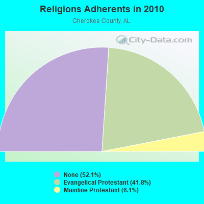
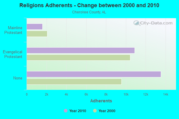
| Religion | Adherents | Congregations |
|---|---|---|
| Evangelical Protestant | 10,865 | 62 |
| Mainline Protestant | 1,590 | 16 |
| Other | - | 1 |
| None | 13,534 | - |
Food Environment Statistics:
| Here: | 1.63 / 10,000 pop. |
| Alabama: | 1.89 / 10,000 pop. |
| This county: | 0.41 / 10,000 pop. |
| Alabama: | 0.20 / 10,000 pop. |
| This county: | 5.71 / 10,000 pop. |
| Alabama: | 6.32 / 10,000 pop. |
| Cherokee County: | 5.71 / 10,000 pop. |
| Alabama: | 5.75 / 10,000 pop. |
| Cherokee County: | 13.3% |
| State: | 11.8% |
| Cherokee County: | 30.7% |
| State: | 31.7% |
| This county: | 14.3% |
| Alabama: | 13.5% |
Health and Nutrition:
| Cedar Bluff: | 46.9% |
| Alabama: | 49.0% |
| This city: | 43.5% |
| Alabama: | 45.7% |
| Here: | 29.7 |
| State: | 28.9 |
| This city: | 17.9% |
| Alabama: | 20.7% |
| This city: | 14.3% |
| Alabama: | 11.0% |
| This city: | 6.7 |
| Alabama: | 6.8 |
| This city: | 34.1% |
| Alabama: | 34.4% |
| Cedar Bluff: | 52.3% |
| Alabama: | 55.2% |
| Cedar Bluff: | 83.2% |
| Alabama: | 79.3% |
More about Health and Nutrition of Cedar Bluff, AL Residents
| Local government employment and payroll (March 2022) | |||||
| Function | Full-time employees | Monthly full-time payroll | Average yearly full-time wage | Part-time employees | Monthly part-time payroll |
|---|---|---|---|---|---|
| Police Protection - Officers | 5 | $25,230 | $60,552 | 0 | $0 |
| Streets and Highways | 2 | $5,438 | $32,628 | 0 | $0 |
| Solid Waste Management | 1 | $992 | $11,904 | 0 | $0 |
| Judicial and Legal | 0 | $0 | 2 | $3,724 | |
| Other Government Administration | 0 | $0 | 1 | $1,009 | |
| Totals for Government | 8 | $31,660 | $47,490 | 3 | $4,733 |
Cedar Bluff government finances - Expenditure in 2017 (per resident):
- Current Operations - Police Protection: $341,000 ($181.96)
Solid Waste Management: $90,000 ($48.03)
Local Fire Protection: $79,000 ($42.16)
Central Staff Services: $77,000 ($41.09)
Regular Highways: $72,000 ($38.42)
General - Other: $55,000 ($29.35)
Parks and Recreation: $36,000 ($19.21)
Elementary and Secondary Education: $28,000 ($14.94)
- General - Interest on Debt: $14,000 ($7.47)
- Other Capital Outlay - Local Fire Protection: $174,000 ($92.85)
Solid Waste Management: $35,000 ($18.68)
Police Protection: $11,000 ($5.87)
- Total Salaries and Wages: $226,000 ($120.60)
Cedar Bluff government finances - Revenue in 2017 (per resident):
- Charges - Solid Waste Management: $140,000 ($74.71)
- Local Intergovernmental - General Local Government Support: $70,000 ($37.35)
- Miscellaneous - Fines and Forfeits: $6,000 ($3.20)
Interest Earnings: $3,000 ($1.60)
Donations From Private Sources: $1,000 ($0.53)
- Tax - General Sales and Gross Receipts: $245,000 ($130.74)
Public Utilities Sales: $147,000 ($78.44)
Alcoholic Beverage Sales: $135,000 ($72.04)
Property: $117,000 ($62.43)
Occupation and Business License - Other: $86,000 ($45.89)
Tobacco Products Sales: $17,000 ($9.07)
Motor Fuels Sales: $16,000 ($8.54)
Other License: $8,000 ($4.27)
Motor Vehicle License: $5,000 ($2.67)
Alcoholic Beverage License: $5,000 ($2.67)
Cedar Bluff government finances - Debt in 2017 (per resident):
- Long Term Debt - Beginning Outstanding - Unspecified Public Purpose: $347,000 ($185.17)
Outstanding Unspecified Public Purpose: $241,000 ($128.60)
Retired Unspecified Public Purpose: $106,000 ($56.56)
Cedar Bluff government finances - Cash and Securities in 2017 (per resident):
- Other Funds - Cash and Securities: $565,000 ($301.49)
Businesses in Cedar Bluff, AL
- Subway: 1
- U-Haul: 1
Strongest AM radio stations in Cedar Bluff:
- WNSI (810 AM; 50 kW; JACKSONVILLE, AL; Owner: UNITED BROADCASTING NETWORK, INC.)
- WKNG (1060 AM; daytime; 50 kW; TALLAPOOSA, GA; Owner: WKNG, INC.)
- WEIS (990 AM; 1 kW; CENTRE, AL; Owner: BAKER ENTERPRISES, INC.)
- WQRX (870 AM; daytime; 10 kW; VALLEY HEAD, AL; Owner: BARINOWSKI INVESTMENT COMPANY)
- WWAM (820 AM; daytime; 50 kW; JASPER, TN; Owner: SHELTON BROADCASTING SYSTEM)
- WFTD (1080 AM; daytime; 50 kW; MARIETTA, GA; Owner: PRIETO ENTERPRISES, INC.)
- WGST (640 AM; 50 kW; ATLANTA, GA; Owner: CITICASTERS LICENSES, L.P.)
- WZTQ (1560 AM; daytime; 1 kW; CENTRE, AL; Owner: RADIO CENTRE, INC.)
- WFLI (1070 AM; 50 kW; LOOKOUT MOUNTAIN, TN; Owner: WFLI, INC.)
- WZOB (1250 AM; 5 kW; FORT PAYNE, AL; Owner: CENTRAL BROADCASTING COMPANY, INC.)
- WCNN (680 AM; 50 kW; NORTH ATLANTA, GA; Owner: DICKEY BROADCASTING COMPANY)
- WMLB (1160 AM; 50 kW; EAST POINT, GA; Owner: ATLANTA AREA BROADCASTING, INC.)
- WGTA (950 AM; 5 kW; SUMMERVILLE, GA; Owner: AZTECA COMMUNICATIONS, INC.)
Strongest FM radio stations in Cedar Bluff:
- WRHY (105.9 FM; CENTRE, AL; Owner: WILLIAMS COMMUNICATIONS, INC.)
- WJCK (88.3 FM; PIEDMONT, AL; Owner: IMMANUEL BROADCASTING NETWORK, INC.)
- W215BA (90.9 FM; ROME, GA; Owner: PENSACOLA CHRISTIAN COLLEGE, INC.)
- WKCX (97.7 FM; ROME, GA; Owner: BRIAR CREEK BROADCASTING CORP.)
- WQSB (105.1 FM; ALBERTVILLE, AL; Owner: SAND MOUNTAIN BROADCASTING SERVICE, INC.)
- WQTU (102.3 FM; ROME, GA; Owner: MCDOUGALD BROADCASTING CORPORATION)
- W212AR (90.3 FM; LINDALE, GA; Owner: WAY-FM MEDIA GROUP, INC.)
- WLJS-FM (91.9 FM; JACKSONVILLE, AL; Owner: BD. OF TRUSTEES/JACKSONVILLE STATE UNIVERSITY)
- WATG (95.7 FM; TRION, GA; Owner: TTA BROADCASTING, INC)
- WTBJ (91.3 FM; OXFORD, AL; Owner: TRINITY CHRISTIAN ACADEMY)
- WGMZ (93.1 FM; GLENCOE, AL; Owner: CAPSTAR TX LIMITED PARTNERSHIP)
- WBDX (102.7 FM; TRENTON, GA; Owner: PARTNERS FOR CHRISTIAN RADIO, INC.)
- WMBW (88.9 FM; CHATTANOOGA, TN; Owner: THE MOODY BIBLE INSTITUTE OF CHICAGO)
- WTBB (89.9 FM; GADSDEN, AL; Owner: TRINITY CHRISTIAN ACADEMY)
- WVOK-FM (97.9 FM; OXFORD, AL; Owner: WOODARD BROADCASTING CO. INC.)
- WSGN (91.5 FM; GADSDEN, AL; Owner: GADSDEN STATE COMMUNITY COLLEGE)
- WKEA-FM (98.3 FM; SCOTTSBORO, AL; Owner: KEA RADIO, INC.)
- WCKS (102.7 FM; FRUITHURST, AL; Owner: WCKS, INC.)
TV broadcast stations around Cedar Bluff:
- WPXH (Channel 44; GADSDEN, AL; Owner: PAXSON COMMUNICATIONS LICENSE COMPANY, LLC)
- W64BJ (Channel 64; SCOTTSBORO, AL; Owner: TRINITY BROADCASTING NETWORK)
- Cedar Bluff, Alabama
- Fatal accident count15
- Vehicles involved in fatal accidents22
- Fatal accidents involving drunk persons:3
- Fatalities16
- Persons involved in fatal accidents41
- Pedestrians involved in fatal accidents1
- Alabama average
- Fatal accident count10267
- Vehicles involved in fatal accidents15382
- Fatal accidents involving drunk persons3126
- Fatalities11378
- Persons involved in fatal accidents24409
- Pedestrians involved in fatal accidents921
- National Bridge Inventory (NBI) Statistics
- 12Number of bridges
- 243ft / 74.1mTotal length
- $18,918,000Total costs
- 33,279Total average daily traffic
- 3,957Total average daily truck traffic
- 46,266Total future (year 2036) average daily traffic
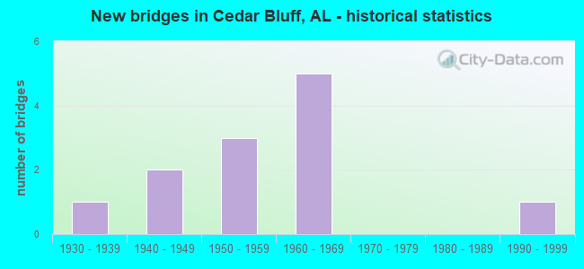
- New bridges - historical statistics
- 11930-1939
- 21940-1949
- 31950-1959
- 51960-1969
- 11990-1999
FCC Registered Antenna Towers:
55 (See the full list of FCC Registered Antenna Towers in Cedar Bluff)FCC Registered Microwave Towers:
15 (See the full list of FCC Registered Microwave Towers in this town)FCC Registered Amateur Radio Licenses:
36 (See the full list of FCC Registered Amateur Radio Licenses in Cedar Bluff)FAA Registered Aircraft:
6- Aircraft: CESSNA 172G (Category: Land, Seats: 4, Weight: Up to 12,499 Pounds, Speed: 105 mph), Engine: CONT MOTOR 0-300 SER (145 HP) (Reciprocating)
N-Number: 1128F, N1128F, N-1128F, Serial Number: 17254723, Year manufactured: 1966, Airworthiness Date: 06/10/1966, Certificate Issue Date: 06/03/2003
Registrant (Individual): Jamie R Hightower, 1750 County Road 43, Cedar Bluff, AL 35959 - Aircraft: FOSTER JAMES J B-80V (Category: Land, Weight: Up to 12,499 Pounds), Engine: Reciprocating
N-Number: 1388A, N1388A, N-1388A, Serial Number: F87011, Certificate Issue Date: 03/03/2020
Registrant (Individual): Ronald W Iaconis, 1130 County Road 49, Cedar Bluff, AL 35959 - Aircraft: CESSNA 182T (Category: Land, Seats: 4, Weight: Up to 12,499 Pounds), Engine: LYCOMING IO-540-AB1A5 (230 HP) (Reciprocating)
N-Number: 2014S, N2014S, N-2014S, Serial Number: 18281772, Year manufactured: 2006, Airworthiness Date: 03/20/2006, Certificate Issue Date: 03/26/2019
Registrant (Individual): Taylen Vaughn, 3610 W Chattooga Dr, Cedar Bluff, AL 35959 - Aircraft: KEUTHAN AIRCRAFT CORP BUCCANEER II (Category: Amphibian, Seats: 2, Weight: Up to 12,499 Pounds), Engine: ROTAX 582SER (65 HP) (2 Cycle)
N-Number: 43310, N43310, N-43310, Serial Number: B11R, Year manufactured: 1994, Airworthiness Date: 01/11/2008, Certificate Issue Date: 09/16/2020
Registrant (Individual): Johnny L Nelson, 938 County Road 624, Cedar Bluff, AL 35959 - Aircraft: H E DAWSON DAVAN 1 (Category: Land, Seats: 4, Weight: Up to 12,499 Pounds), Engine: 4 Cycle
N-Number: 44DV, N44DV, N-44DV, Serial Number: 41105, Certificate Issue Date: 02/24/2020
Registrant (Individual): Harry E Dawson, Po Box 62, Cedar Bluff, AL 35959 - Aircraft: AMERICAN AA-5 (Category: Land, Seats: 4, Weight: Up to 12,499 Pounds, Speed: 67 mph), Engine: Reciprocating
N-Number: 6812T, N6812T, N-6812T, Serial Number: AA5-0127, Year manufactured: 1972, Airworthiness Date: 07/11/1973, Certificate Issue Date: 12/27/2013
Registrant (Individual): Frank M Chambless, 1950 County Road 121, Cedar Bluff, AL 35959
Deregistered: Cancel Date: 04/20/2004
2004 - 2018 National Fire Incident Reporting System (NFIRS) incidents
- Fire incident types reported to NFIRS in Cedar Bluff, AL
- 25049.9%Structure Fires
- 19138.1%Outside Fires
- 377.4%Mobile Property/Vehicle Fires
- 234.6%Other
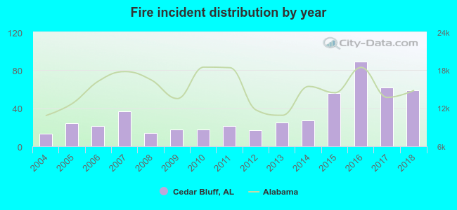 According to the data from the years 2004 - 2018 the average number of fires per year is 33. The highest number of reported fire incidents - 89 took place in 2016, and the least - 13 in 2004. The data has an increasing trend.
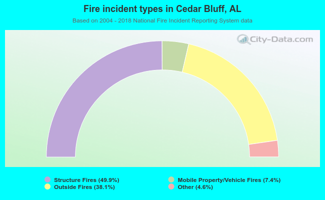 When looking into fire subcategories, the most reports belonged to: Structure Fires (49.9%), and Outside Fires (38.1%).
| Most common first names in Cedar Bluff, AL among deceased individuals | ||
| Name | Count | Lived (average) |
|---|---|---|
| James | 41 | 70.7 years |
| John | 30 | 70.5 years |
| William | 30 | 73.7 years |
| Robert | 26 | 67.9 years |
| Mary | 18 | 70.9 years |
| Charles | 15 | 70.7 years |
| Leonard | 12 | 72.7 years |
| Henry | 11 | 77.1 years |
| Mildred | 11 | 80.0 years |
| Frances | 11 | 78.8 years |
| Most common last names in Cedar Bluff, AL among deceased individuals | ||
| Last name | Count | Lived (average) |
|---|---|---|
| Crane | 22 | 70.1 years |
| Wood | 18 | 74.8 years |
| Daniel | 18 | 69.1 years |
| Smith | 18 | 78.4 years |
| Bishop | 17 | 73.5 years |
| Johnson | 15 | 75.7 years |
| Davis | 14 | 75.0 years |
| Webb | 11 | 69.2 years |
| Cobia | 11 | 82.8 years |
| Wilson | 11 | 69.6 years |
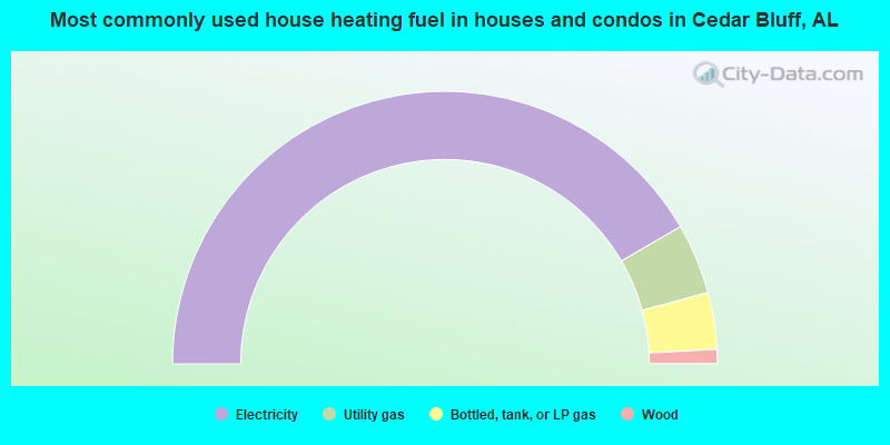
- 83.3%Electricity
- 8.4%Utility gas
- 6.7%Bottled, tank, or LP gas
- 1.7%Wood
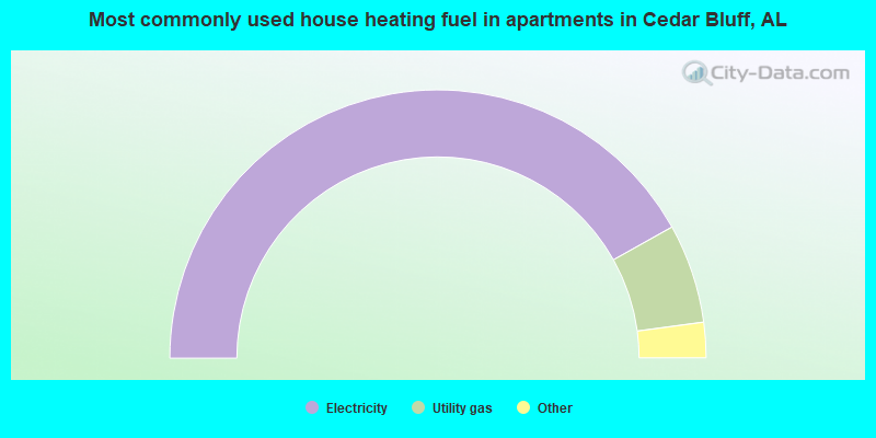
- 84.2%Electricity
- 12.0%Utility gas
- 1.4%Bottled, tank, or LP gas
- 1.4%Fuel oil, kerosene, etc.
- 1.0%No fuel used
Cedar Bluff compared to Alabama state average:
- Unemployed percentage below state average.
- Black race population percentage significantly below state average.
- Hispanic race population percentage significantly below state average.
- Foreign-born population percentage significantly below state average.
- Number of college students significantly below state average.

|
Total of 5 patent applications in 2008-2024.