Chapman, Alabama
Submit your own pictures of this place and show them to the world
- OSM Map
- General Map
- Google Map
- MSN Map

| Males: 907 | |
| Females: 956 |
| Median resident age: | 39.8 years |
| Alabama median age: | 35.8 years |
Zip code: 36456
| Chapman: | $56,449 |
| AL: | $59,674 |
Estimated per capita income in 2022: $29,922 (it was $17,627 in 2000)
Chapman CCD income, earnings, and wages data
Estimated median house or condo value in 2022: $100,700 (it was $46,100 in 2000)
| Chapman: | $100,700 |
| AL: | $200,900 |
Detailed information about poverty and poor residents in Chapman, AL
Compare current foreclosures near Chapman, AL:
| Photo | Address | Area | Beds / Baths | Price | Details |
|---|---|---|---|---|---|

|
#1
South St
Greenville, AL 36037
|
2,804 sq. feet
|
2 baths 4 beds |
$105,395
|
show details |

|
#2
Oak St
Greenville, AL 36037
|
1,675 sq. feet
|
1 baths - beds |
show details | |

|
#3
Pineapple Hwy
Greenville, AL 36037
|
1,624 sq. feet
|
1 baths - beds |
show details | |

|
#4
Withers Rd
Georgiana, AL 36033
|
2,128 sq. feet
|
1 baths - beds |
show details | |

|
#5
W Perdue St
Greenville, AL 36037
|
950 sq. feet
|
1 baths - beds |
show details | |

|
#6
Gregory St
Greenville, AL 36037
|
1,440 sq. feet
|
1 baths - beds |
show details | |

|
#7
Lucille St
Greenville, AL 36037
|
1,332 sq. feet
|
1 baths - beds |
show details | |

|
#8
Harrison St
Greenville, AL 36037
|
1,510 sq. feet
|
1 baths - beds |
show details | |

|
#9
Mckenzie St
Greenville, AL 36037
|
2,616 sq. feet
|
1 baths - beds |
show details | |

|
#10
S Park St
Greenville, AL 36037
|
2,456 sq. feet
|
1 baths - beds |
show details |
| Photo | Address | Area | Beds / Baths | Price | Details |
|---|---|---|---|---|---|

|
#11
South St
Greenville, AL 36037
|
1,997 sq. feet
|
1 baths - beds |
show details | |

|
#12
Bell St
Greenville, AL 36037
|
1,349 sq. feet
|
1 baths - beds |
show details | |

|
#13
E State Highway 106
Georgiana, AL 36033
|
1,588 sq. feet
|
1 baths - beds |
show details | |

|
#14
Halso Mill Rd
Greenville, AL 36037
|
2,227 sq. feet
|
1 baths - beds |
show details | |

|
#15
Hickory St
Greenville, AL 36037
|
1,904 sq. feet
|
1 baths - beds |
show details | |

|
#16
Fort Dale Rd
Greenville, AL 36037
|
1,805 sq. feet
|
1 baths - beds |
show details | |

|
#17
Fort Dale Rd
Greenville, AL 36037
|
3,881 sq. feet
|
1 baths - beds |
show details | |

|
#18
N Pine St
Greenville, AL 36037
|
1,248 sq. feet
|
1 baths - beds |
show details | |

|
#19
Pinedale St
Greenville, AL 36037
|
1,405 sq. feet
|
1 baths - beds |
show details | |

|
#20
Halso Mill Rd
Greenville, AL 36037
|
1,991 sq. feet
|
1 baths - beds |
show details |
| Photo | Address | Area | Beds / Baths | Price | Details |
|---|---|---|---|---|---|

|
#21
Halso Mill Rd
Greenville, AL 36037
|
2,508 sq. feet
|
2 baths - beds |
show details | |

|
#22
Airport Rd
Greenville, AL 36037
|
1,950 sq. feet
|
1 baths - beds |
show details | |

|
#23
S Us Highway 31
Georgiana, AL 36033
|
1,876 sq. feet
|
1 baths - beds |
show details | |

|
#24
Stinson Rd
Georgiana, AL 36033
|
1,716 sq. feet
|
1 baths - beds |
show details | |

|
#25
Oakwood St
Georgiana, AL 36033
|
- sq. feet
|
- baths - beds |
show details | |

|
#26
Hardscramble Rd
Greenville, AL 36037
|
- sq. feet
|
- baths - beds |
show details | |

|
#27
Cunningham St
Greenville, AL 36037
|
1,064 sq. feet
|
- baths - beds |
show details | |

|
#28
Cunningham St
Greenville, AL 36037
|
- sq. feet
|
- baths - beds |
show details | |

|
#29
Thames St
Greenville, AL 36037
|
1,467 sq. feet
|
- baths - beds |
show details | |

|
#30
S Mt Zion Rd
Greenville, AL 36037
|
- sq. feet
|
- baths - beds |
show details |
| Photo | Address | Area | Beds / Baths | Price | Details |
|---|---|---|---|---|---|

|
#31
Doctor Hall Rd
Georgiana, AL 36033
|
1,075 sq. feet
|
- baths - beds |
show details | |

|
#32
Hardscramble Rd
Greenville, AL 36037
|
- sq. feet
|
- baths - beds |
show details | |

|
#33
Hardscramble Rd
Greenville, AL 36037
|
- sq. feet
|
- baths - beds |
show details | |

|
#34
Hartley St
Mc Kenzie, AL 36456
|
2,114 sq. feet
|
- baths - beds |
show details | |

|
#35
Flowers St
Greenville, AL 36037
|
- sq. feet
|
- baths - beds |
show details | |

|
#36
Davison St
Mc Kenzie, AL 36456
|
1,025 sq. feet
|
- baths - beds |
show details | |

|
#37
Hardscramble Rd
Greenville, AL 36037
|
- sq. feet
|
- baths - beds |
show details | |

|
#38
Flowers St
Greenville, AL 36037
|
- sq. feet
|
- baths - beds |
show details | |

|
#39
N Conecuh St
Greenville, AL 36037
|
- sq. feet
|
- baths - beds |
show details | |

|
#40
N Conecuh St
Greenville, AL 36037
|
- sq. feet
|
- baths - beds |
show details |
| Photo | Address | Area | Beds / Baths | Price | Details |
|---|---|---|---|---|---|

|
#41
Pecan Rd
Greenville, AL 36037
|
- sq. feet
|
- baths - beds |
show details | |

|
#42
Flowers St
Greenville, AL 36037
|
- sq. feet
|
- baths - beds |
show details | |

|
#43
Ivy St Apt B2
Mc Kenzie, AL 36456
|
- sq. feet
|
- baths - beds |
show details | |

|
#44
Wise Rd
Mc Kenzie, AL 36456
|
- sq. feet
|
- baths - beds |
show details | |

|
#45
Mckenzie Grade
Georgiana, AL 36033
|
- sq. feet
|
- baths - beds |
show details | |

|
#46
Meadowbrook Ln, Lot 15
Greenville, AL 36037
|
- sq. feet
|
- baths - beds |
show details | |

|
#47
Mccall Rd
Georgiana, AL 36033
|
- sq. feet
|
- baths - beds |
show details | |

|
#48
Boswell Blvd
Georgiana, AL 36033
|
1,300 sq. feet
|
- baths - beds |
show details | |

|
#49
Butler Est
Greenville, AL 36037
|
1,125 sq. feet
|
- baths - beds |
show details | |

|
Check over 1 million property listings on Foreclosure.com!
|
browse all offers | |||

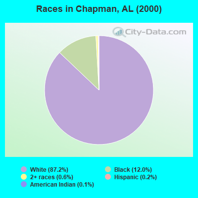
- 1,71187.2%White alone
- 23512.0%Black alone
- 110.6%Two or more races
- 30.2%Hispanic
- 20.1%American Indian alone
 Recent articles from our blog. Our writers, many of them Ph.D. graduates or candidates, create easy-to-read articles on a wide variety of topics.
Current Local Time: CST time zone
Elevation: 265 feet
Land area: 136.0 square miles.
Population density: 14 people per square mile (very low).

| Chapman CCD: | 0.4% ($199) |
| Alabama: | 0.4% ($289) |
Nearest city with pop. 50,000+: Montgomery, AL  (52.7 miles , pop. 201,568).
Nearest city with pop. 1,000,000+: Houston, TX (531.1 miles , pop. 1,953,631).
Nearest cities:
), ), ), ), ), Latitude: 31.71 N, Longitude: 86.74 W
Area code commonly used in this area: 334

| Here: | 2.9% |
| Alabama: | 2.6% |
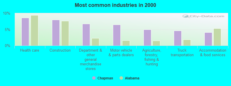
- Health care (8.6%)
- Construction (8.0%)
- Department & other general merchandise stores (6.7%)
- Motor vehicle & parts dealers (6.5%)
- Agriculture, forestry, fishing & hunting (4.9%)
- Truck transportation (4.6%)
- Accommodation & food services (4.1%)
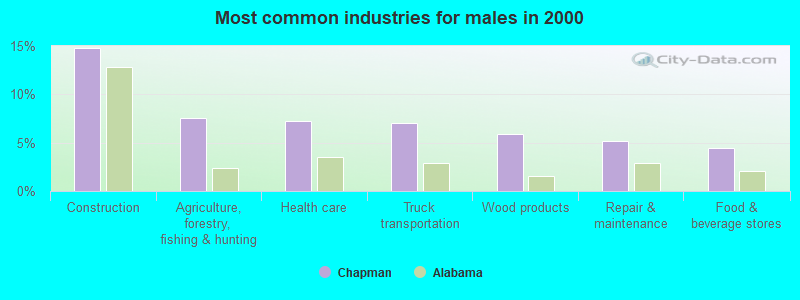
- Construction (14.8%)
- Agriculture, forestry, fishing & hunting (7.5%)
- Health care (7.3%)
- Truck transportation (7.0%)
- Wood products (5.9%)
- Repair & maintenance (5.2%)
- Food & beverage stores (4.5%)
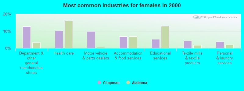
- Department & other general merchandise stores (12.7%)
- Health care (10.2%)
- Motor vehicle & parts dealers (9.9%)
- Accommodation & food services (6.9%)
- Educational services (5.2%)
- Textile mills & textile products (4.4%)
- Personal & laundry services (3.9%)
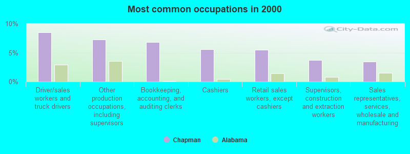
- Driver/sales workers and truck drivers (8.5%)
- Other production occupations, including supervisors (7.2%)
- Bookkeeping, accounting, and auditing clerks (6.8%)
- Cashiers (5.6%)
- Retail sales workers, except cashiers (5.4%)
- Supervisors, construction and extraction workers (3.7%)
- Sales representatives, services, wholesale and manufacturing (3.4%)

- Driver/sales workers and truck drivers (14.3%)
- Other production occupations, including supervisors (7.7%)
- Supervisors, construction and extraction workers (6.8%)
- Electrical equipment mechanics and other installation, maintenance, and repair workers, including supervisors (5.9%)
- Vehicle and mobile equipment mechanics, installers, and repairers (5.2%)
- Cashiers (4.5%)
- Metal workers and plastic workers (4.5%)
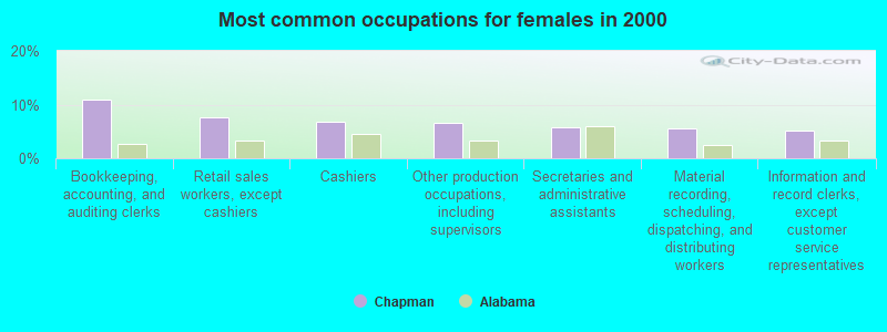
- Bookkeeping, accounting, and auditing clerks (11.0%)
- Retail sales workers, except cashiers (7.7%)
- Cashiers (6.9%)
- Other production occupations, including supervisors (6.6%)
- Secretaries and administrative assistants (5.8%)
- Material recording, scheduling, dispatching, and distributing workers (5.5%)
- Information and record clerks, except customer service representatives (5.2%)
Average climate in Chapman, Alabama
Based on data reported by over 4,000 weather stations


Tornado activity:
Chapman-area historical tornado activity is below Alabama state average. It is 33% greater than the overall U.S. average.
On 4/18/1969, a category F4 (max. wind speeds 207-260 mph) tornado 10.6 miles away from the Chapman place center killed 2 people and injured 14 people and caused between $50,000 and $500,000 in damages.
On 4/23/1971, a category F4 tornado 16.1 miles away from the place center caused between $5000 and $50,000 in damages.
Earthquake activity:
Chapman-area historical earthquake activity is significantly above Alabama state average. It is 55% greater than the overall U.S. average.On 10/24/1997 at 08:35:17, a magnitude 4.9 (4.8 MB, 4.2 MS, 4.9 LG, Depth: 6.2 mi, Class: Light, Intensity: IV - V) earthquake occurred 51.2 miles away from the city center
On 1/18/1999 at 07:00:53, a magnitude 4.8 (4.8 MB, 4.0 LG, Depth: 0.6 mi) earthquake occurred 121.3 miles away from the city center
On 4/29/2003 at 08:59:39, a magnitude 4.9 (4.4 MB, 4.6 MW, 4.9 LG) earthquake occurred 203.2 miles away from Chapman center
On 11/7/2004 at 11:20:21, a magnitude 4.3 (4.3 MW, Depth: 3.1 mi) earthquake occurred 95.7 miles away from the city center
On 6/24/1975 at 11:11:36, a magnitude 4.5 (4.5 MB) earthquake occurred 153.3 miles away from Chapman center
On 4/29/2003 at 08:59:39, a magnitude 4.6 (4.6 MW, Depth: 12.3 mi) earthquake occurred 203.2 miles away from Chapman center
Magnitude types: regional Lg-wave magnitude (LG), body-wave magnitude (MB), surface-wave magnitude (MS), moment magnitude (MW)
Natural disasters:
The number of natural disasters in Butler County (21) is greater than the US average (15).Major Disasters (Presidential) Declared: 11
Emergencies Declared: 6
Causes of natural disasters: Hurricanes: 9, Storms: 9, Floods: 7, Tornadoes: 6, Winds: 4, Drought: 1, Snowfall: 1, Winter Storm: 1, Other: 1 (Note: some incidents may be assigned to more than one category).
Hospitals and medical centers near Chapman:
- RELIABLE HOME HEALTH (Home Health Center, about 5 miles away; GEORGIANA, AL)
- GEORGIANA HEALTH AND REHABILITATION, L L C (Nursing Home, about 5 miles away; GEORGIANA, AL)
- L V STABLER HOME HEALTH AGENCY (Home Health Center, about 11 miles away; GREENVILLE, AL)
- SOUTHERNCARE GREENVILLE (Hospital, about 11 miles away; GREENVILLE, AL)
- COMFORT CARE HOSPICE OF GREENVILLE (Hospital, about 12 miles away; GREENVILLE, AL)
- CROWNE HEALTH CARE OF GREENVILLE (Nursing Home, about 12 miles away; GREENVILLE, AL)
Airports located in Chapman:
- Mc Gowin Field Airport (5AL1) (Runways: 1)
Colleges/universities with over 2000 students nearest to Chapman:
- Troy University (about 47 miles; Troy, AL; Full-time enrollment: 16,148)
- Alabama State University (about 53 miles; Montgomery, AL; FT enrollment: 5,457)
- Faulkner University (about 56 miles; Montgomery, AL; FT enrollment: 2,887)
- Auburn University at Montgomery (about 57 miles; Montgomery, AL; FT enrollment: 4,092)
- Enterprise State Community College (about 61 miles; Enterprise, AL; FT enrollment: 2,101)
- Tuskegee University (about 79 miles; Tuskegee, AL; FT enrollment: 2,810)
- George C Wallace State Community College-Dothan (about 80 miles; Dothan, AL; FT enrollment: 3,611)
Points of interest:
Notable locations in Chapman: Providence - Mount Pisgah Volunteer Fire Department (A), B S and W Volunteer Fire Department (B), Starlington Volunteer Fire Department (C). Display/hide their locations on the map
Churches in Chapman include: Morrow Church (A), Mount Pisgah Church (B), Mount Pleasant Church (C), Kenzie Chapel (D), Antioch West Church (E), Ebenezer Missionary Baptist Church (F), Wald Church (G), Shacklesville Church (H), Providence Church (I). Display/hide their locations on the map
Cemeteries: Old Bethel Cemetery (1), Mount Pisgah Cemetery (2), Hopewell Cemetery (3), Brushy Creek Cemetery (4), Antioch West Cemetery (5), Ebenezer Cemetery (6). Display/hide their locations on the map
Reservoirs: Tills Pond (A), Stallworth Pond (B), McGowin Lake (C), Lake Charold (D), Casey Pond (E). Display/hide their locations on the map
Streams, rivers, and creeks: Powell Branch (A), Oaklog Creek (B), Stallings Creek (C), Hawkins Creek (D), Deep Step Creek (E), Clear Creek (F), Beaver Creek (G), Sulphur Branch (H), Arnold Branch (I). Display/hide their locations on the map
Parks in Chapman include: Locomotive Roadside Park (1), Butler County State Wildlife Management Area (2). Display/hide their locations on the map
Birthplace of: Joe Taylor (baseball) - Baseball player.
| This place: | 2.4 people |
| Alabama: | 2.5 people |
| This place: | 73.0% |
| Whole state: | 67.8% |
| This place: | 2.6% |
| Whole state: | 4.7% |
Likely homosexual households (counted as self-reported same-sex unmarried-partner households)
- Lesbian couples: 0.1% of all households
- Gay men: 0.4% of all households
| This place: | 10.7% |
| Whole state: | 16.1% |
| This place: | 3.0% |
| Whole state: | 7.3% |
For population 15 years and over in Chapman:
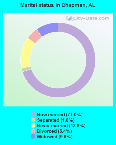
- Never married: 13.8%
- Now married: 71.0%
- Separated: 1.6%
- Widowed: 9.8%
- Divorced: 5.4%
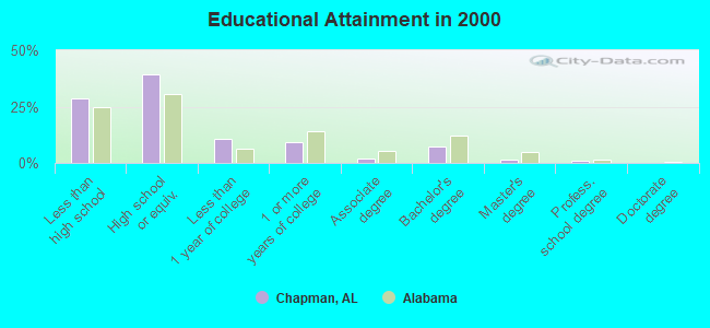
For population 25 years and over in Chapman:
- High school or higher: 71.2%
- Bachelor's degree or higher: 9.8%
- Graduate or professional degree: 2.2%
- Unemployed: 8.0%
- Mean travel time to work (commute): 31.5 minutes
| Here: | 13.6 |
| Alabama average: | 13.2 |
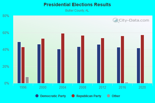
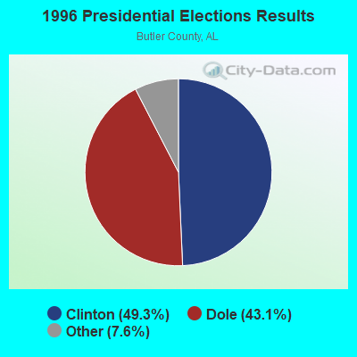
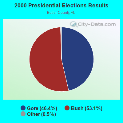
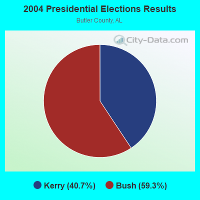
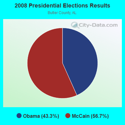
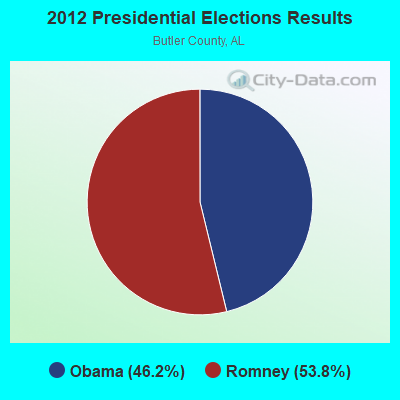

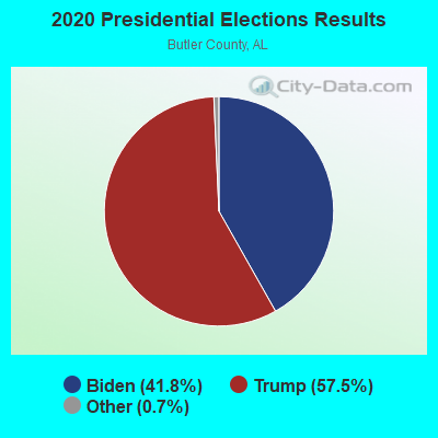
Graphs represent county-level data. Detailed 2008 Election Results
Religion statistics for Chapman, AL (based on Butler County data)
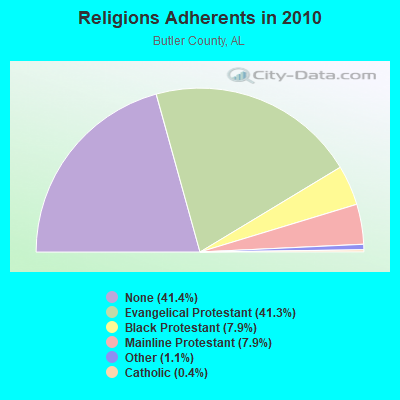
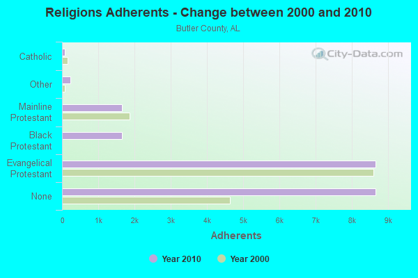
| Religion | Adherents | Congregations |
|---|---|---|
| Evangelical Protestant | 8,653 | 63 |
| Black Protestant | 1,657 | 8 |
| Mainline Protestant | 1,653 | 17 |
| Other | 238 | 3 |
| Catholic | 77 | 1 |
| None | 8,669 | - |
Food Environment Statistics:
| This county: | 1.49 / 10,000 pop. |
| Alabama: | 1.89 / 10,000 pop. |
| This county: | 1.98 / 10,000 pop. |
| Alabama: | 0.65 / 10,000 pop. |
| Butler County: | 9.42 / 10,000 pop. |
| Alabama: | 6.32 / 10,000 pop. |
| Butler County: | 8.43 / 10,000 pop. |
| Alabama: | 5.75 / 10,000 pop. |
| Butler County: | 14.2% |
| Alabama: | 11.8% |
| Butler County: | 35.5% |
| Alabama: | 31.7% |
| Butler County: | 7.7% |
| Alabama: | 13.5% |
Strongest AM radio stations in Chapman:
- WASG (550 AM; 25 kW; ATMORE, AL; Owner: 550 AM, INC)
- WGYV (1380 AM; daytime; 1 kW; GREENVILLE, AL; Owner: ROBERT JOHN WILLIAMSON)
- WJOX (690 AM; 50 kW; BIRMINGHAM, AL; Owner: CITADEL BROADCASTING COMPANY)
- WMSP (740 AM; 10 kW; MONTGOMERY, AL; Owner: CUMULUS LICENSING CORP.)
- WYNI (930 AM; 5 kW; MONROEVILLE, AL; Owner: MCKISSICK ENTERPRISES)
- WDJC (850 AM; 50 kW; BIRMINGHAM, AL; Owner: KIMTRON, INC.)
- WAPI (1070 AM; 50 kW; BIRMINGHAM, AL; Owner: CITADEL BROADCASTING COMPANY)
- WEBY (1330 AM; 25 kW; MILTON, FL; Owner: SPINNAKER LICENSE CORPORATION)
- WACV (1170 AM; 10 kW; MONTGOMERY, AL; Owner: MONTGOMERY BROADCAST PROPERTIES, LTD)
- WNSI (810 AM; 50 kW; JACKSONVILLE, AL; Owner: UNITED BROADCASTING NETWORK, INC.)
- WTBF (970 AM; 5 kW; TROY, AL; Owner: TROY BROADCASTING CORP.)
- WQLS (1200 AM; 10 kW; OZARK, AL; Owner: STYLES BROADCASTING OF DOTHAN, INC.)
- WSJC (810 AM; 50 kW; MAGEE, MS; Owner: FAMILY TALK RADIO)
Strongest FM radio stations in Chapman:
- WKXN (95.9 FM; GREENVILLE, AL; Owner: AUTAUGAVILLE RADIO, INC.)
- WPGG (93.3 FM; EVERGREEN, AL; Owner: GULF COAST BROADCASTING COMPANY, INC)
- WAPR (88.3 FM; SELMA, AL; Owner: UA-ASU-TSU EDUCATIONAL RADIO CORP.)
- WQLD (104.3 FM; LUVERNE, AL; Owner: CAPSTAR TX LIMITED PARTNERSHIP)
- WZHT (105.7 FM; TROY, AL; Owner: CAPSTAR TX LIMITED PARTNERSHIP)
- WFXX (107.7 FM; GEORGIANA, AL; Owner: JEFFREY K. HAYNES)
- WQZX (94.3 FM; GREENVILLE, AL; Owner: HAYNES BROADCASTING, INC.)
- WLWI-FM (92.3 FM; MONTGOMERY, AL; Owner: CUMULUS LICENSING CORP.)
- WSTF (91.5 FM; ANDALUSIA, AL; Owner: MONTGOMERY CHRISTIAN EDUC. RADIO,INC)
TV broadcast stations around Chapman:
- WDIQ (Channel 2; DOZIER, AL; Owner: ALABAMA EDUCATIONAL TELEVISION COMMISSION)
- WAKA (Channel 8; SELMA, AL; Owner: ALABAMA BROADCASTING PARTNERS)
- WRJM-TV (Channel 67; TROY, AL; Owner: JOSIE PARK BROADCASTING, INC.)
- WSFA (Channel 12; MONTGOMERY, AL; Owner: LIBCO, INC.)
- WCOV-TV (Channel 20; MONTGOMERY, AL; Owner: WOODS COMMUNICATIONS CORPORATION)
- WNCF (Channel 32; MONTGOMERY, AL; Owner: CHANNEL 32 MONTGOMERY LLC)
FCC Registered Antenna Towers:
12 (See the full list of FCC Registered Antenna Towers in Chapman)FCC Registered Broadcast Land Mobile Towers:
2- Mcgowin Forestry Lookout Tower (Lat: 31.696000 Lon: -86.684417), Call Sign: KIA739,
Assigned Frequencies: 159.420 MHz, Grant Date: 11/10/2022, Expiration Date: 02/04/2033, Registrant: Alabama Forestry Commission, 2201 Cong. Dickinson Dr., Montgomery, AL 36109, Phone: (334) 467-1339, Email:
- Lat: 31.674306 Lon: -86.711250, Call Sign: WRCL367,
Assigned Frequencies: 151.677 MHz, 151.685 MHz, Grant Date: 10/30/2018, Expiration Date: 10/30/2028, Certifier: Ryan Daniels, Registrant: Hunton Andrews Kurth LLP, 951 E Byrd St., Richmond, VA 23219, Phone: (804) 788-8756, Email:
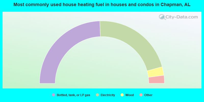
- 48.9%Bottled, tank, or LP gas
- 42.5%Electricity
- 4.5%Wood
- 2.8%Utility gas
- 1.3%No fuel used
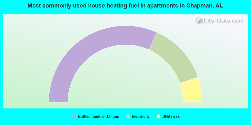
- 63.5%Bottled, tank, or LP gas
- 25.9%Electricity
- 10.6%Utility gas
Chapman compared to Alabama state average:
- Median house value below state average.
- Unemployed percentage below state average.
- Black race population percentage below state average.
- Hispanic race population percentage significantly below state average.
- Foreign-born population percentage significantly below state average.
- Renting percentage significantly below state average.
- Length of stay since moving in significantly above state average.
- Number of rooms per house significantly below state average.
- House age significantly below state average.
- Percentage of population with a bachelor's degree or higher below state average.