Clarence, Alabama
Submit your own pictures of this place and show them to the world
- OSM Map
- General Map
- Google Map
- MSN Map

| Males: 2,750 | |
| Females: 2,875 |
| Median resident age: | 36.1 years |
| Alabama median age: | 35.8 years |
Zip code: 35952
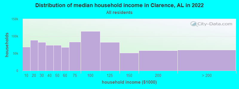
| Clarence: | $50,328 |
| AL: | $59,674 |
Estimated per capita income in 2022: $29,401 (it was $16,309 in 2000)
Clarence CCD income, earnings, and wages data
Estimated median house or condo value in 2022: $147,070 (it was $63,200 in 2000)
| Clarence: | $147,070 |
| AL: | $200,900 |
Mean prices in 2022: all housing units: $209,672; detached houses: $249,358; townhouses or other attached units: $218,248; mobile homes: $67,057; occupied boats, rvs, vans, etc.: $43,848
Detailed information about poverty and poor residents in Clarence, AL


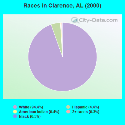
- 4,77994.4%White alone
- 2244.4%Hispanic
- 180.4%American Indian alone
- 150.3%Black alone
- 170.3%Two or more races
- 50.10%Asian alone
- 40.08%Native Hawaiian and Other
Pacific Islander alone - 10.02%Other race alone
 Recent articles from our blog. Our writers, many of them Ph.D. graduates or candidates, create easy-to-read articles on a wide variety of topics.
Current Local Time: CST time zone
Elevation: 787 feet
Land area: 73.4 square miles.
Population density: 77 people per square mile (very low).

| Clarence CCD: | 0.3% ($199) |
| Alabama: | 0.4% ($289) |
Nearest city with pop. 50,000+: Huntsville, AL  (45.1 miles , pop. 158,216).
Nearest city with pop. 200,000+: Birmingham, AL (45.4 miles , pop. 242,820).
Nearest city with pop. 1,000,000+: Chicago, IL (541.2 miles , pop. 2,896,016).
Nearest cities:
), ), ), )Latitude: 34.08 N, Longitude: 86.39 W
Area code commonly used in this area: 205

| Here: | 2.3% |
| Alabama: | 2.6% |
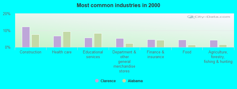
- Construction (12.3%)
- Health care (6.7%)
- Educational services (5.7%)
- Department & other general merchandise stores (5.4%)
- Finance & insurance (4.6%)
- Food (4.3%)
- Agriculture, forestry, fishing & hunting (4.2%)
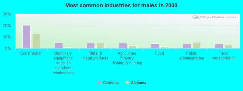
- Construction (20.1%)
- Machinery, equipment, supplies merchant wholesalers (4.7%)
- Metal & metal products (4.5%)
- Agriculture, forestry, fishing & hunting (4.4%)
- Food (4.4%)
- Public administration (3.7%)
- Truck transportation (3.6%)
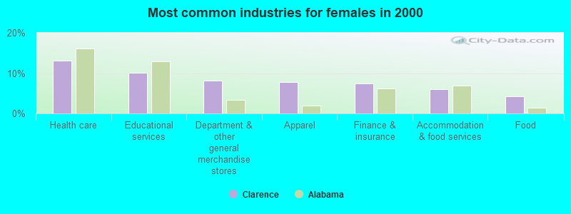
- Health care (13.0%)
- Educational services (10.2%)
- Department & other general merchandise stores (8.2%)
- Apparel (7.7%)
- Finance & insurance (7.5%)
- Accommodation & food services (6.1%)
- Food (4.3%)
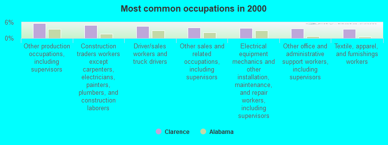
- Other production occupations, including supervisors (5.6%)
- Construction traders workers except carpenters, electricians, painters, plumbers, and construction laborers (4.8%)
- Driver/sales workers and truck drivers (4.6%)
- Other sales and related occupations, including supervisors (4.0%)
- Electrical equipment mechanics and other installation, maintenance, and repair workers, including supervisors (3.8%)
- Other office and administrative support workers, including supervisors (3.6%)
- Textile, apparel, and furnishings workers (3.4%)
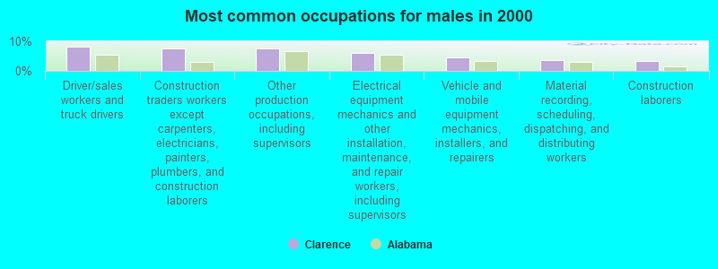
- Driver/sales workers and truck drivers (8.1%)
- Construction traders workers except carpenters, electricians, painters, plumbers, and construction laborers (7.6%)
- Other production occupations, including supervisors (7.5%)
- Electrical equipment mechanics and other installation, maintenance, and repair workers, including supervisors (6.1%)
- Vehicle and mobile equipment mechanics, installers, and repairers (4.7%)
- Material recording, scheduling, dispatching, and distributing workers (3.6%)
- Construction laborers (3.5%)
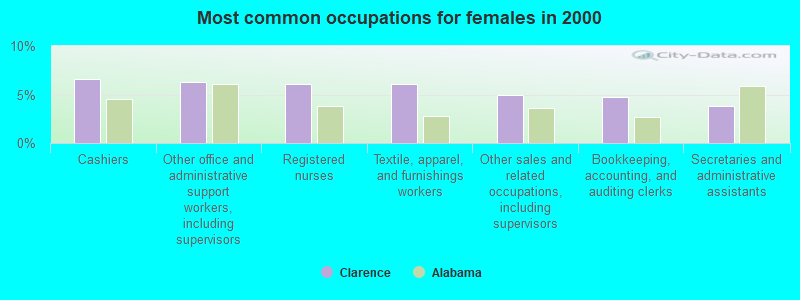
- Cashiers (6.6%)
- Other office and administrative support workers, including supervisors (6.3%)
- Registered nurses (6.1%)
- Textile, apparel, and furnishings workers (6.1%)
- Other sales and related occupations, including supervisors (4.9%)
- Bookkeeping, accounting, and auditing clerks (4.7%)
- Secretaries and administrative assistants (3.8%)
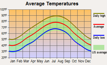
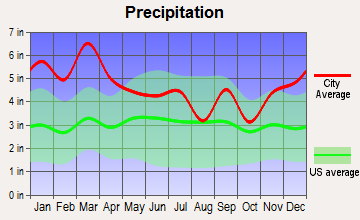
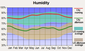
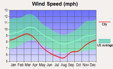
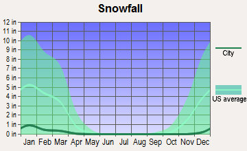
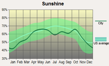
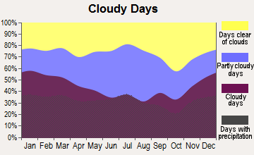
Average climate in Clarence, Alabama
Based on data reported by over 4,000 weather stations
(lower is better)

Air Quality Index (AQI) level in 2022 was 68.7. This is about average.
| City: | 68.7 |
| U.S.: | 72.6 |
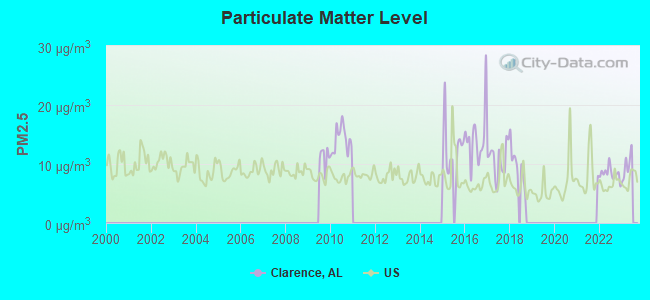
Particulate Matter (PM2.5) [µg/m3] level in 2022 was 8.35. This is about average. Closest monitor was 23.9 miles away from the city center.
| City: | 8.35 |
| U.S.: | 8.11 |
Tornado activity:
Clarence-area historical tornado activity is slightly above Alabama state average. It is 170% greater than the overall U.S. average.
On 11/24/2001, a category F4 (max. wind speeds 207-260 mph) tornado 6.5 miles away from the Clarence place center injured 22 people and caused $1 million in damages.
On 11/18/1957, a category F4 tornado 10.1 miles away from the place center killed 3 people and injured 12 people and caused between $50,000 and $500,000 in damages.
Earthquake activity:
Clarence-area historical earthquake activity is significantly above Alabama state average. It is 133% greater than the overall U.S. average.On 4/29/2003 at 08:59:39, a magnitude 4.9 (4.4 MB, 4.6 MW, 4.9 LG, Class: Light, Intensity: IV - V) earthquake occurred 52.2 miles away from Clarence center
On 1/18/1999 at 07:00:53, a magnitude 4.8 (4.8 MB, 4.0 LG, Depth: 0.6 mi) earthquake occurred 68.1 miles away from Clarence center
On 4/29/2003 at 08:59:39, a magnitude 4.6 (4.6 MW, Depth: 12.3 mi) earthquake occurred 52.1 miles away from the city center
On 6/24/1975 at 11:11:36, a magnitude 4.5 (4.5 MB) earthquake occurred 86.7 miles away from the city center
On 10/24/1997 at 08:35:17, a magnitude 4.9 (4.8 MB, 4.2 MS, 4.9 LG, Depth: 6.2 mi) earthquake occurred 211.0 miles away from the city center
On 4/18/2008 at 09:36:59, a magnitude 5.4 (5.1 MB, 4.8 MS, 5.4 MW, 5.2 MW, Class: Moderate, Intensity: VI - VII) earthquake occurred 313.5 miles away from Clarence center
Magnitude types: regional Lg-wave magnitude (LG), body-wave magnitude (MB), surface-wave magnitude (MS), moment magnitude (MW)
Natural disasters:
The number of natural disasters in Blount County (21) is greater than the US average (15).Major Disasters (Presidential) Declared: 12
Emergencies Declared: 5
Causes of natural disasters: Storms: 14, Floods: 10, Tornadoes: 10, Winds: 5, Hurricanes: 3, Drought: 1, Snowfall: 1, Winter Storm: 1, Other: 1 (Note: some incidents may be assigned to more than one category).
Hospitals and medical centers near Clarence:
- ALTOONA HEALTH AND REHAB (Nursing Home, about 6 miles away; ALTOONA, AL)
- TLC NURSING CENTER (Nursing Home, about 9 miles away; ONEONTA, AL)
- GOLDEN LIVING CENTER - ONEONTA (Nursing Home, about 11 miles away; ONEONTA, AL)
- AMEDISYS HOME HEALTH OF BLOUNTSVILLE (Home Health Center, about 11 miles away; ONEONTA, AL)
- CARE FIRST HOME HEALTH OF BLOUNT COUNTY (Home Health Center, about 11 miles away; ONEONTA, AL)
Colleges/universities with over 2000 students nearest to Clarence:
- Snead State Community College (about 16 miles; Boaz, AL; Full-time enrollment: 2,023)
- George C Wallace State Community College-Hanceville (about 23 miles; Hanceville, AL; FT enrollment: 4,486)
- Gadsden State Community College (about 24 miles; Gadsden, AL; FT enrollment: 4,650)
- Jefferson State Community College (about 35 miles; Birmingham, AL; FT enrollment: 6,041)
- Jacksonville State University (about 41 miles; Jacksonville, AL; FT enrollment: 7,566)
- Northeast Alabama Community College (about 43 miles; Rainsville, AL; FT enrollment: 2,409)
- University of Alabama in Huntsville (about 47 miles; Huntsville, AL; FT enrollment: 6,006)
Points of interest:
Notable locations in Clarence: Graveman Dairy Farm (A), Kneeves Poultry Farm (B), Slab Creek Golf Course (C), Maple Hill Golf Course (D), Snead Volunteer Fire Department (E), Susan Moore Volunteer Fire Department (F). Display/hide their locations on the map
Churches in Clarence include: Mount Carmel Church (A), Mount Moriah Church (B), Pleasant Grove Methodist Church (C), New Emmaus Church (D), New Home Church (E), Pine Grove Church (F), Mount Zion Church of God (G), Pleasant Hope Church (H), Pleasant Ridge Church (I). Display/hide their locations on the map
Cemeteries: Holland Cemetery (1), Painter Cemetery (2), Ellison Cemetery (3), Mount Moriah Cemetery (4), Lamb Cemetery (5), Bynum Cemetery (6), Lebanon Cemetery (7). Display/hide their locations on the map
Lakes and reservoirs: Hanna Pond (A), Snead Lake Two (B), Snead Lake One (C), Wrights Lake (D). Display/hide their locations on the map
Streams, rivers, and creeks: Tanyard Branch (A), Slab Creek (B), Rocky Branch (C), Pine Pole Branch (D), Parker Branch (E), Mining Pond Branch (F), Little Mud Creek (G), Kenchelow Creek (H), Handley Branch (I). Display/hide their locations on the map
| This place: | 2.6 people |
| Alabama: | 2.5 people |
| This place: | 73.0% |
| Whole state: | 67.8% |
| This place: | 3.8% |
| Whole state: | 4.7% |
Likely homosexual households (counted as self-reported same-sex unmarried-partner households)
- Lesbian couples: 0.3% of all households
- Gay men: 0.3% of all households
| This place: | 13.3% |
| Whole state: | 16.1% |
| This place: | 6.0% |
| Whole state: | 7.3% |
For population 15 years and over in Clarence:
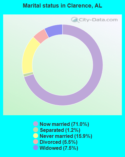
- Never married: 15.9%
- Now married: 71.0%
- Separated: 1.2%
- Widowed: 7.5%
- Divorced: 5.5%
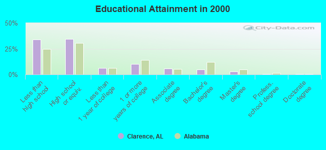
For population 25 years and over in Clarence:
- High school or higher: 65.9%
- Bachelor's degree or higher: 8.9%
- Graduate or professional degree: 3.9%
- Unemployed: 3.9%
- Mean travel time to work (commute): 35.2 minutes
| Here: | 14.9 |
| Alabama average: | 13.2 |
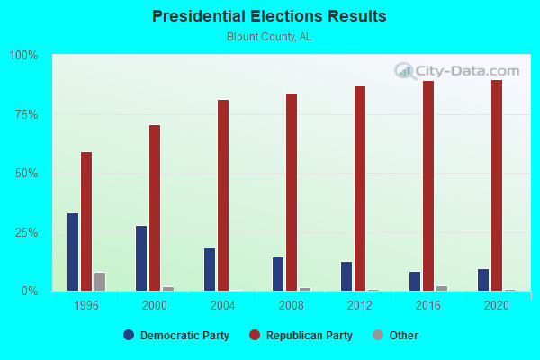
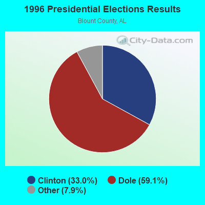
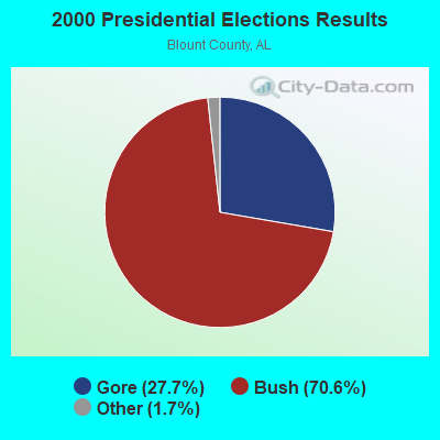
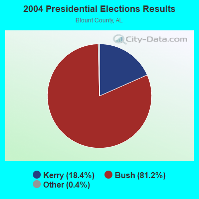
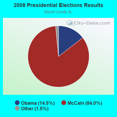
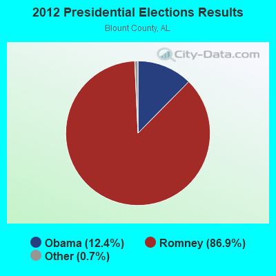
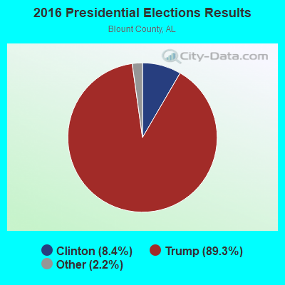
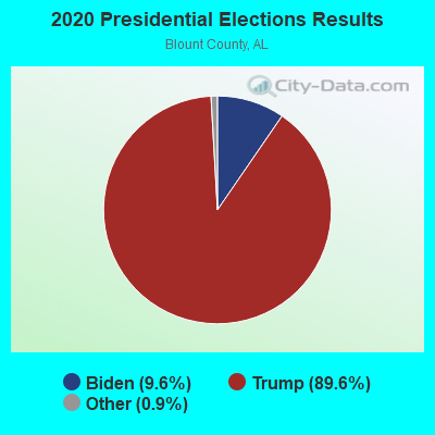
Graphs represent county-level data. Detailed 2008 Election Results
Religion statistics for Clarence, AL (based on Blount County data)
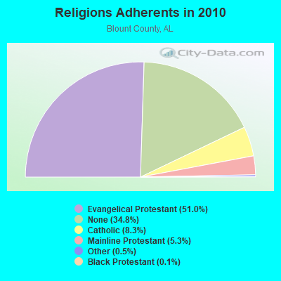
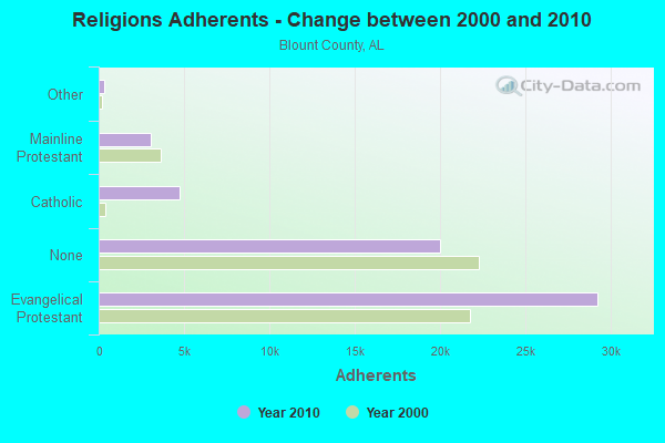
| Religion | Adherents | Congregations |
|---|---|---|
| Evangelical Protestant | 29,223 | 122 |
| Catholic | 4,744 | 1 |
| Mainline Protestant | 3,035 | 29 |
| Other | 292 | 2 |
| Black Protestant | 58 | 2 |
| None | 19,970 | - |
Food Environment Statistics:
| Here: | 1.06 / 10,000 pop. |
| State: | 1.89 / 10,000 pop. |
| Blount County: | 0.18 / 10,000 pop. |
| State: | 0.20 / 10,000 pop. |
| Blount County: | 0.18 / 10,000 pop. |
| Alabama: | 0.65 / 10,000 pop. |
| This county: | 5.13 / 10,000 pop. |
| State: | 6.32 / 10,000 pop. |
| Blount County: | 2.48 / 10,000 pop. |
| Alabama: | 5.75 / 10,000 pop. |
| This county: | 10.5% |
| Alabama: | 11.8% |
| Blount County: | 31.5% |
| Alabama: | 31.7% |
| Blount County: | 19.9% |
| Alabama: | 13.5% |
Strongest AM radio stations in Clarence:
- WDJC (850 AM; 50 kW; BIRMINGHAM, AL; Owner: KIMTRON, INC.)
- WNSI (810 AM; 50 kW; JACKSONVILLE, AL; Owner: UNITED BROADCASTING NETWORK, INC.)
- WJOX (690 AM; 50 kW; BIRMINGHAM, AL; Owner: CITADEL BROADCASTING COMPANY)
- WAPI (1070 AM; 50 kW; BIRMINGHAM, AL; Owner: CITADEL BROADCASTING COMPANY)
- WCRL (1570 AM; 2 kW; ONEONTA, AL; Owner: BLOUNT COUNTY BROADCASTING SERVICE, INC.)
- WAAX (570 AM; 5 kW; GADSDEN, AL; Owner: CAPSTAR TX LIMITED PARTNERSHIP)
- WLOR (1550 AM; 50 kW; HUNTSVILLE, AL; Owner: BCA RADIO, LLC)
- WJBY (930 AM; 5 kW; RAINBOW CITY, AL; Owner: GADSDEN BROADCASTING COMPANY, INC.)
- WGAD (1350 AM; 5 kW; GADSDEN, AL; Owner: DEKALB COUNTY COMMUNITY RADIO, INC.)
- WKNG (1060 AM; daytime; 50 kW; TALLAPOOSA, GA; Owner: WKNG, INC.)
- WWAM (820 AM; daytime; 50 kW; JASPER, TN; Owner: SHELTON BROADCASTING SYSTEM)
- WFLI (1070 AM; 50 kW; LOOKOUT MOUNTAIN, TN; Owner: WFLI, INC.)
- WGST (640 AM; 50 kW; ATLANTA, GA; Owner: CITICASTERS LICENSES, L.P.)
Strongest FM radio stations in Clarence:
- WKXX (102.9 FM; ATTALLA, AL; Owner: BROADCAST MEDIA LLC)
- WQSB (105.1 FM; ALBERTVILLE, AL; Owner: SAND MOUNTAIN BROADCASTING SERVICE, INC.)
- WYDE-FM (101.1 FM; CULLMAN, AL; Owner: KIMTRON, INC.)
- WRAX (107.7 FM; BIRMINGHAM, AL; Owner: CITADEL BROADCASTING COMPANY)
- WKLD (97.7 FM; ONEONTA, AL; Owner: BLOUNT COUNTY BROADCASTING SERVICE INC.)
- WAFN-FM (92.7 FM; ARAB, AL; Owner: FUN MEDIA GROUP, INC.)
- WRSA-FM (96.9 FM; DECATUR, AL; Owner: NCA, INC.)
- WRHY (105.9 FM; CENTRE, AL; Owner: WILLIAMS COMMUNICATIONS, INC.)
- WTWX-FM (95.9 FM; GUNTERSVILLE, AL; Owner: GUNTERSVILLE BROADCASTING CO., INC.)
- WTBJ (91.3 FM; OXFORD, AL; Owner: TRINITY CHRISTIAN ACADEMY)
- WSGN (91.5 FM; GADSDEN, AL; Owner: GADSDEN STATE COMMUNITY COLLEGE)
- WAHR (99.1 FM; HUNTSVILLE, AL; Owner: BCA RADIO, LLC)
- W289AC (105.7 FM; HUNTSVILLE, AL; Owner: WILLIAM PAXTON ROGERS)
- WTBB (89.9 FM; GADSDEN, AL; Owner: TRINITY CHRISTIAN ACADEMY)
- WBPT (106.9 FM; BIRMINGHAM, AL; Owner: CXR HOLDINGS, INC.)
- WBHK (98.7 FM; WARRIOR, AL; Owner: CXR HOLDINGS, INC.)
- WZZK-FM (104.7 FM; BIRMINGHAM, AL; Owner: CXR HOLDINGS, INC.)
- WFMH-FM (95.5 FM; HOLLY POND, AL; Owner: VOICE OF CULLMAN, L.L.C.)
- W298AF (107.5 FM; HADEN, AL; Owner: HADEN RADIO COMPANY)
- WVOK-FM (97.9 FM; OXFORD, AL; Owner: WOODARD BROADCASTING CO. INC.)
TV broadcast stations around Clarence:
- WPXH (Channel 44; GADSDEN, AL; Owner: PAXSON COMMUNICATIONS LICENSE COMPANY, LLC)
- WTJP (Channel 60; GADSDEN, AL; Owner: TRINITY BROADCASTING NETWORK)
- WZDX (Channel 54; HUNTSVILLE, AL; Owner: HUNTSVILLE TELEVISION ACQUISITION CORP.)
- W15AP (Channel 15; GADSDEN, AL; Owner: WBRC LICENSE, INC.)

- 51.8%Electricity
- 42.2%Bottled, tank, or LP gas
- 3.4%Utility gas
- 1.9%Wood
- 0.7%Fuel oil, kerosene, etc.
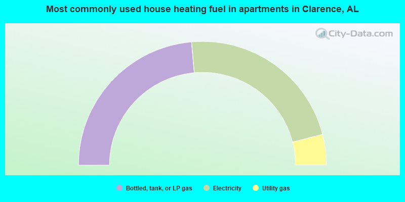
- 47.2%Bottled, tank, or LP gas
- 44.8%Electricity
- 8.0%Utility gas
Clarence compared to Alabama state average:
- Unemployed percentage significantly below state average.
- Black race population percentage significantly below state average.
- Median age below state average.
- Foreign-born population percentage significantly below state average.
- Renting percentage below state average.
- Length of stay since moving in significantly above state average.
- Number of rooms per house significantly below state average.
- House age significantly below state average.
- Number of college students below state average.
- Percentage of population with a bachelor's degree or higher below state average.
Clarence on our top lists:
- #2 on the list of "Top 101 cities with largest percentage of males in industries: machinery, equipment, and supplies merchant wholesalers (population 5,000+)"
- #4 on the list of "Top 101 cities with largest percentage of females in industries: apparel (population 5,000+)"
- #5 on the list of "Top 101 cities with largest percentage of females in occupations: construction trades workers except carpenters, electricians, painters, plumbers, and construction laborers (population 5,000+)"
- #5 on the list of "Top 101 cities with largest percentage of females in occupations: woodworkers (population 5,000+)"
- #5 on the list of "Top 101 cities with largest percentage of females in industries: rail transportation (population 5,000+)"
- #10 on the list of "Top 101 cities with largest percentage of females in industries: department and other general merchandise stores (population 5,000+)"
- #14 on the list of "Top 101 cities with largest percentage of females in industries: wood products (population 5,000+)"
- #16 on the list of "Top 101 cities with largest percentage of females in occupations: food processing workers (population 5,000+)"
- #17 on the list of "Top 101 cities with largest percentage of males in occupations: construction trades workers except carpenters, electricians, painters, plumbers, and construction laborers (population 5,000+)"
- #23 on the list of "Top 101 cities with largest percentage of females in industries: food (population 5,000+)"
- #23 on the list of "Top 101 cities with largest percentage of males in industries: apparel (population 5,000+)"
- #24 on the list of "Top 101 cities with largest percentage of males in occupations: religious workers (population 5,000+)"
- #25 on the list of "Top 101 cities with largest percentage of females in industries: recyclable material merchant wholesalers (population 5,000+)"
- #29 on the list of "Top 101 cities with largest percentage of females in occupations: art and design workers (population 5,000+)"
- #29 on the list of "Top 101 cities with largest percentage of males in industries: department and other general merchandise stores (population 5,000+)"
- #31 on the list of "Top 101 cities with largest percentage of females in industries: farm supplies merchant wholesalers (population 5,000+)"
- #34 on the list of "Top 101 cities with largest percentage of males in industries: food (population 5,000+)"
- #37 on the list of "Top 101 cities with largest percentage of males in industries: metals and minerals, except petroleum, merchant wholesalers (population 5,000+)"
- #38 on the list of "Top 101 cities with largest percentage of females in industries: nonmetallic mineral products (population 5,000+)"
- #41 on the list of "Top 101 cities with largest percentage of males in industries: motor vehicles, parts and supplies merchant wholesalers (population 5,000+)"
- #48 on the list of "Top 101 counties with highest percentage of residents voting for Romney (Republican) in the 2012 Presidential Election"