Colony, Kentucky
Submit your own pictures of this place and show them to the world
- OSM Map
- General Map
- Google Map
- MSN Map

| Males: 2,164 | |
| Females: 2,166 |
| Median resident age: | 34.9 years |
| Kentucky median age: | 35.9 years |
Zip code: 40741
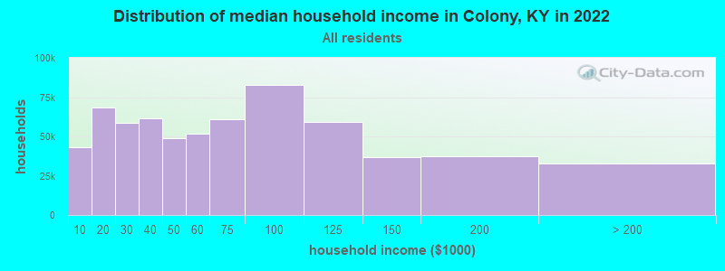
| Colony: | $51,539 |
| KY: | $59,341 |
Estimated per capita income in 2022: $25,068 (it was $13,054 in 2000)
Colony CCD income, earnings, and wages data
Estimated median house or condo value in 2022: $154,263 (it was $63,100 in 2000)
| Colony: | $154,263 |
| KY: | $196,300 |
Detailed information about poverty and poor residents in Colony, KY
Compare current foreclosures near Colony, KY:
| Photo | Address | Area | Beds / Baths | Price | Details |
|---|---|---|---|---|---|

|
#1
Oneal Rd
London, KY 40741
|
1,610 sq. feet
|
2 baths 3 beds |
show details | |

|
#2
E Highway 30
East Bernstadt, KY 40729
|
1,392 sq. feet
|
1 baths 3 beds |
show details | |

|
#3
Ky 2417
Corbin, KY 40701
|
1,467 sq. feet
|
1 baths 3 beds |
show details | |

|
#4
Riverside Loop
Lily, KY 40740
|
1,125 sq. feet
|
2 baths 3 beds |
show details | |

|
#5
Riverside Loop
Lily, KY 40740
|
1,120 sq. feet
|
1 baths 3 beds |
show details | |

|
#6
Hensley Rd
East Bernstadt, KY 40729
|
1,566 sq. feet
|
1 baths 4 beds |
show details | |

|
#7
Kirby Ln
London, KY 40741
|
1,296 sq. feet
|
1 baths 2 beds |
show details | |

|
#8
Pond Lick Rd
Annville, KY 40402
|
1,648 sq. feet
|
1 baths 3 beds |
show details | |

|
#9
Madison Cir
London, KY 40741
|
1,972 sq. feet
|
2 baths 3 beds |
show details | |

|
#10
Gordon Hill Pike
Corbin, KY 40701
|
2,304 sq. feet
|
2 baths 3 beds |
show details |
| Photo | Address | Area | Beds / Baths | Price | Details |
|---|---|---|---|---|---|

|
#11
Sweetbriar Cir
London, KY 40744
|
2,184 sq. feet
|
2 baths 4 beds |
show details | |

|
#12
Heavenly View Ln
Somerset, KY 42501
|
2,176 sq. feet
|
2 baths 3 beds |
show details | |

|
#13
Keeneland Trl
Corbin, KY 40701
|
1,408 sq. feet
|
1 baths 3 beds |
show details | |

|
#14
Goodwin St
Corbin, KY 40701
|
1,776 sq. feet
|
1 baths 3 beds |
show details | |

|
#15
W Main St
Mount Vernon, KY 40456
|
1,344 sq. feet
|
1 baths 4 beds |
show details | |

|
#16
Talon Trl
London, KY 40744
|
1,703 sq. feet
|
2 baths 3 beds |
show details | |

|
#17
Southard Rd
London, KY 40741
|
1,512 sq. feet
|
1 baths 4 beds |
show details | |

|
#18
Mcfadden Cir
Corbin, KY 40701
|
2,100 sq. feet
|
2 baths 3 beds |
show details | |

|
#19
Lewis St
Corbin, KY 40701
|
1,008 sq. feet
|
1 baths 3 beds |
show details | |

|
#20
Poindexter St
London, KY 40741
|
2,187 sq. feet
|
2 baths 3 beds |
show details |
| Photo | Address | Area | Beds / Baths | Price | Details |
|---|---|---|---|---|---|

|
#21
Highway 490
East Bernstadt, KY 40729
|
1,236 sq. feet
|
2 baths 4 beds |
show details | |

|
#22
Bill Ln
London, KY 40744
|
980 sq. feet
|
1 baths 3 beds |
show details | |

|
#23
Owens Ln
London, KY 40744
|
960 sq. feet
|
2 baths 3 beds |
show details | |

|
#24
Pleasant Grove Loop
Manchester, KY 40962
|
800 sq. feet
|
1 baths 3 beds |
show details | |

|
#25
W Gordon St
Corbin, KY 40701
|
3,519 sq. feet
|
2 baths 4 beds |
show details | |

|
#26
Southland Dr
London, KY 40744
|
1,676 sq. feet
|
1 baths 3 beds |
show details | |

|
#27
Highway 490
East Bernstadt, KY 40729
|
- sq. feet
|
2 baths 3 beds |
show details | |

|
#28
Caldwell St
Corbin, KY 40701
|
- sq. feet
|
2 baths 3 beds |
show details | |

|
#29
Hensley Dr
London, KY 40741
|
1,222 sq. feet
|
1 baths 3 beds |
show details | |

|
#30
Golden Eagle Dr
London, KY 40744
|
1,268 sq. feet
|
2 baths 3 beds |
show details |
| Photo | Address | Area | Beds / Baths | Price | Details |
|---|---|---|---|---|---|

|
#31
Hatcher Rd
London, KY 40741
|
1,050 sq. feet
|
1 baths 2 beds |
show details | |

|
#32
Powder Mill Rd
London, KY 40741
|
1,288 sq. feet
|
2 baths 3 beds |
show details | |

|
#33
Hopkins Cemetery Rd
Lily, KY 40740
|
1,236 sq. feet
|
2 baths 3 beds |
show details | |

|
#34
Helvetia Rd
London, KY 40741
|
1,678 sq. feet
|
2 baths 3 beds |
show details | |

|
#35
Powder Mill Rd
London, KY 40741
|
4,708 sq. feet
|
3 baths 4 beds |
show details | |

|
#36
Riva Ridge Trl
Corbin, KY 40701
|
2,424 sq. feet
|
2 baths 3 beds |
show details | |

|
#37
Pl Hubbard Rd
London, KY 40741
|
936 sq. feet
|
1 baths 2 beds |
show details | |

|
#38
17th St
Corbin, KY 40701
|
960 sq. feet
|
1 baths 2 beds |
show details | |

|
#39
Echo Valley Rd
Lily, KY 40740
|
2,325 sq. feet
|
2 baths 3 beds |
show details | |

|
#40
E Highway 30
East Bernstadt, KY 40729
|
576 sq. feet
|
1 baths 3 beds |
show details |
| Photo | Address | Area | Beds / Baths | Price | Details |
|---|---|---|---|---|---|

|
#41
Eagles Nest Rd
Corbin, KY 40701
|
1,924 sq. feet
|
2 baths 3 beds |
show details | |

|
#42
Abutment Rd
London, KY 40741
|
1,420 sq. feet
|
1 baths 3 beds |
show details | |

|
#43
Kirkwood Dr
London, KY 40744
|
1,904 sq. feet
|
2 baths 3 beds |
show details | |

|
#44
Holly Ln
Corbin, KY 40701
|
3,142 sq. feet
|
2 baths 4 beds |
show details | |

|
#45
Upper Calloway Loop
Mount Vernon, KY 40456
|
- sq. feet
|
- baths - beds |
show details | |

|
#46
Kevington Dr
London, KY 40744
|
3,375 sq. feet
|
2 baths - beds |
show details | |

|
#47
Bluegrass Rd
East Bernstadt, KY 40729
|
940 sq. feet
|
1 baths - beds |
show details | |

|
#48
Greenmount Bond Rd
London, KY 40741
|
1,300 sq. feet
|
1 baths - beds |
show details | |

|
#49
Big Cave Rd
Orlando, KY 40460
|
- sq. feet
|
- baths - beds |
show details | |

|
Check over 1 million property listings on Foreclosure.com!
|
browse all offers | |||

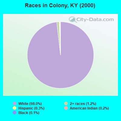
- 3,91998.0%White alone
- 501.2%Two or more races
- 140.3%Hispanic
- 100.2%American Indian alone
- 50.1%Black alone
- 20.05%Asian alone
- 10.02%Native Hawaiian and Other
Pacific Islander alone
Races in Colony detailed stats: ancestries, foreign born residents, place of birth
 Recent articles from our blog. Our writers, many of them Ph.D. graduates or candidates, create easy-to-read articles on a wide variety of topics.
Current Local Time: EST time zone
Elevation: 950 feet
Land area: 59.8 square miles.
Population density: 72 people per square mile (very low).

| Colony CCD: | 0.6% ($368) |
| Kentucky: | 0.8% ($610) |
Nearest city with pop. 50,000+: Fayette, KY  (62.6 miles , pop. 260,512).
Nearest city with pop. 1,000,000+: Chicago, IL (373.5 miles , pop. 2,896,016).
Nearest cities:
), ), ), ), Latitude: 37.16 N, Longitude: 84.19 W
Area code commonly used in this area: 606

| Here: | 4.1% |
| Kentucky: | 3.8% |
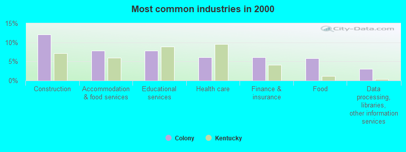
- Construction (12.0%)
- Accommodation & food services (7.8%)
- Educational services (7.8%)
- Health care (6.1%)
- Finance & insurance (6.1%)
- Food (5.8%)
- Data processing, libraries, other information services (3.1%)
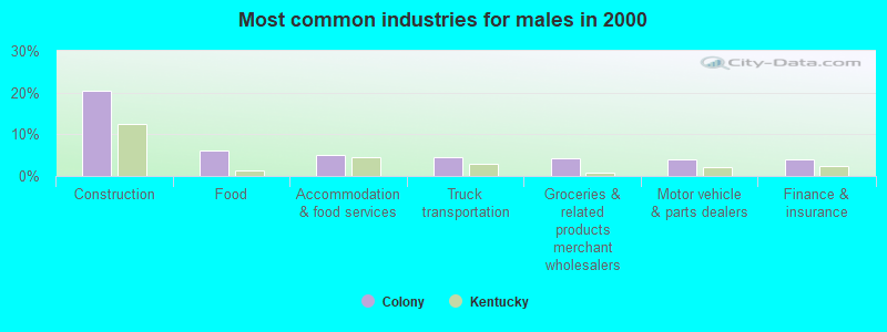
- Construction (20.3%)
- Food (6.2%)
- Accommodation & food services (5.1%)
- Truck transportation (4.5%)
- Groceries & related products merchant wholesalers (4.4%)
- Motor vehicle & parts dealers (4.0%)
- Finance & insurance (3.9%)
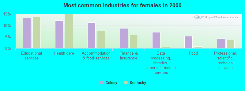
- Educational services (13.3%)
- Health care (12.2%)
- Accommodation & food services (11.3%)
- Finance & insurance (8.8%)
- Data processing, libraries, other information services (7.0%)
- Food (5.3%)
- Professional, scientific, technical services (4.2%)
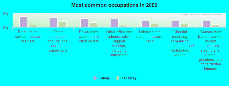
- Retail sales workers, except cashiers (6.2%)
- Other production occupations, including supervisors (5.5%)
- Driver/sales workers and truck drivers (5.0%)
- Other office and administrative support workers, including supervisors (4.9%)
- Laborers and material movers, hand (3.8%)
- Material recording, scheduling, dispatching, and distributing workers (3.6%)
- Construction traders workers except carpenters, electricians, painters, plumbers, and construction laborers (3.6%)
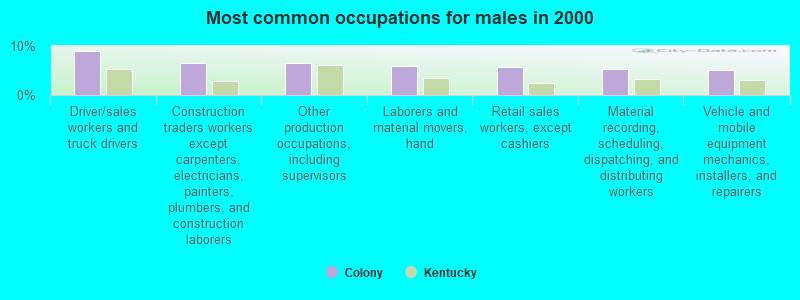
- Driver/sales workers and truck drivers (9.0%)
- Construction traders workers except carpenters, electricians, painters, plumbers, and construction laborers (6.4%)
- Other production occupations, including supervisors (6.4%)
- Laborers and material movers, hand (6.0%)
- Retail sales workers, except cashiers (5.8%)
- Material recording, scheduling, dispatching, and distributing workers (5.2%)
- Vehicle and mobile equipment mechanics, installers, and repairers (5.0%)

- Other office and administrative support workers, including supervisors (10.3%)
- Retail sales workers, except cashiers (6.7%)
- Information and record clerks, except customer service representatives (4.5%)
- Other production occupations, including supervisors (4.3%)
- Other teachers, instructors, education, training, and library occupations (4.3%)
- Preschool, kindergarten, elementary, and middle school teachers (4.2%)
- Cashiers (4.2%)
Average climate in Colony, Kentucky
Based on data reported by over 4,000 weather stations


(lower is better)
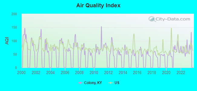
Air Quality Index (AQI) level in 2022 was 62.9. This is about average.
| City: | 62.9 |
| U.S.: | 72.6 |
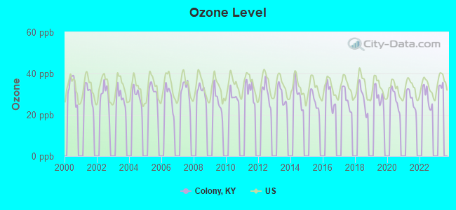
Ozone [ppb] level in 2022 was 28.6. This is about average. Closest monitor was 15.9 miles away from the city center.
| City: | 28.6 |
| U.S.: | 33.3 |
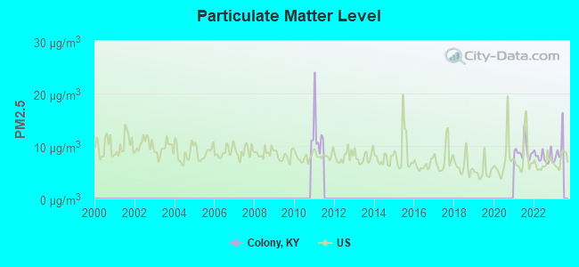
Particulate Matter (PM2.5) [µg/m3] level in 2022 was 7.87. This is about average. Closest monitor was 8.6 miles away from the city center.
| City: | 7.87 |
| U.S.: | 8.11 |
Tornado activity:
Colony-area historical tornado activity is slightly below Kentucky state average. It is 8% smaller than the overall U.S. average.
On 6/29/1973, a category F3 (max. wind speeds 158-206 mph) tornado 6.5 miles away from the Colony place center injured 2 people and caused between $50,000 and $500,000 in damages.
On 4/3/1974, a category F3 tornado 10.0 miles away from the place center killed 7 people and injured 40 people and caused between $500,000 and $5,000,000 in damages.
Earthquake activity:
Colony-area historical earthquake activity is significantly above Kentucky state average. It is 76% greater than the overall U.S. average.On 7/27/1980 at 18:52:21, a magnitude 5.2 (5.1 MB, 4.7 MS, 5.0 UK, 5.2 UK, Class: Moderate, Intensity: VI - VII) earthquake occurred 73.8 miles away from the city center
On 4/18/2008 at 09:36:59, a magnitude 5.4 (5.1 MB, 4.8 MS, 5.4 MW, 5.2 MW) earthquake occurred 220.8 miles away from the city center
On 9/7/1988 at 02:28:09, a magnitude 4.6 (4.5 MB, 4.6 LG, Class: Light, Intensity: IV - V) earthquake occurred 70.4 miles away from the city center
On 11/30/1973 at 07:48:41, a magnitude 4.7 (4.7 MB, 4.6 ML) earthquake occurred 94.8 miles away from the city center
On 8/9/2020 at 12:07:37, a magnitude 5.1 (5.1 MW, Depth: 4.7 mi) earthquake occurred 178.0 miles away from Colony center
On 4/18/2008 at 09:36:59, a magnitude 5.2 (5.2 MW, Depth: 8.9 mi) earthquake occurred 220.7 miles away from Colony center
Magnitude types: regional Lg-wave magnitude (LG), body-wave magnitude (MB), local magnitude (ML), surface-wave magnitude (MS), moment magnitude (MW)
Natural disasters:
The number of natural disasters in Laurel County (17) is near the US average (15).Major Disasters (Presidential) Declared: 11
Emergencies Declared: 2
Causes of natural disasters: Floods: 7, Storms: 7, Tornadoes: 6, Winds: 3, Fires: 2, Mudslides: 2, Snows: 2, Winter Storms: 2, Blizzard: 1, Freeze: 1, Hurricane: 1, Landslide: 1, Snowfall: 1, Other: 1 (Note: some incidents may be assigned to more than one category).
Hospitals and medical centers near Colony:
- LONDON DIALYSIS CLINIC (Dialysis Facility, about 5 miles away; LONDON, KY)
- PROFESSIONAL HOME HEALTH CARE, INC (Home Health Center, about 8 miles away; LONDON, KY)
- SETON HOME HEALTH SERVICES (Home Health Center, about 11 miles away; LONDON, KY)
- CHRISTIAN HEALTH CENTER (Nursing Home, about 16 miles away; CORBIN, KY)
- LIFELINE ROCKCASTLE HOME HEALTH (Home Health Center, about 16 miles away; MOUNT VERNON, KY)
Colleges/universities with over 2000 students nearest to Colony:
- Somerset Community College (about 25 miles; Somerset, KY; Full-time enrollment: 4,698)
- University of the Cumberlands (about 30 miles; Williamsburg, KY; FT enrollment: 3,585)
- Eastern Kentucky University (about 41 miles; Richmond, KY; FT enrollment: 13,525)
- Lincoln Memorial University (about 50 miles; Harrogate, TN; FT enrollment: 3,706)
- Hazard Community and Technical College (about 57 miles; Hazard, KY; FT enrollment: 2,087)
- Lindsey Wilson College (about 62 miles; Columbia, KY; FT enrollment: 2,552)
- Bluegrass Community and Technical College (about 63 miles; Lexington, KY; FT enrollment: 8,560)
Points of interest:
Notable locations in Colony: Daniel Boone Motocross Park (A), Swiss Colony Volunteer Fire Department (B). Display/hide their locations on the map
Churches in Colony include: London Community Church (A), White Oak Baptist Church (B), Warrens Grove Church (C), Upper Colony Church (D), Sinking Creek Baptist Church (E), Pine Top Church (F), Pine Creek Church (G), Mount Moriah Church (H), Liberty Baptist Church (I). Display/hide their locations on the map
Cemeteries: Nix Cemetery (1), Whitt Cemetery (2). Display/hide their locations on the map
Reservoir: Wood Creek Lake (A). Display/hide its location on the map
Streams, rivers, and creeks: Hawk Creek (A), Laurel Branch (B), Line Creek (C), Pine Creek (D), Poison Honey Fork (E), Powder Mill Creek (F), White Oak Creek (G), Big Branch (H), Big Dog Branch (I). Display/hide their locations on the map
| This place: | 2.6 people |
| Kentucky: | 2.5 people |
| This place: | 75.0% |
| Whole state: | 66.9% |
| This place: | 5.6% |
| Whole state: | 6.4% |
Likely homosexual households (counted as self-reported same-sex unmarried-partner households)
- Lesbian couples: 0.4% of all households
- Gay men: 0.4% of all households
| This place: | 22.8% |
| Whole state: | 15.8% |
| This place: | 6.2% |
| Whole state: | 6.6% |
10 people in other noninstitutional group quarters in 2000
For population 15 years and over in Colony:
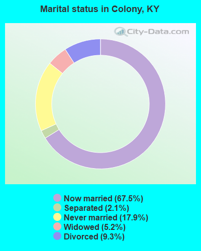
- Never married: 17.9%
- Now married: 67.5%
- Separated: 2.1%
- Widowed: 5.2%
- Divorced: 9.3%
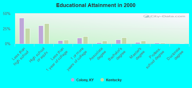
For population 25 years and over in Colony:
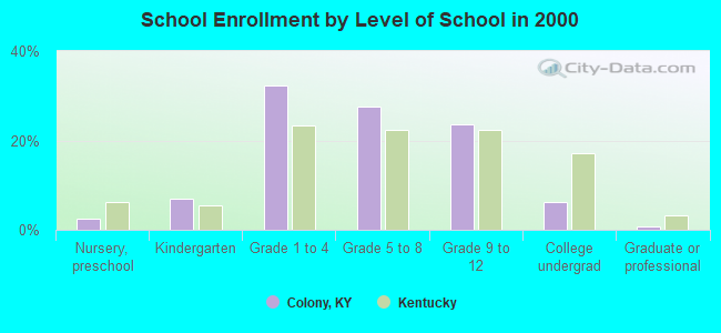
- High school or higher: 57.2%
- Bachelor's degree or higher: 10.4%
- Graduate or professional degree: 3.7%
- Unemployed: 5.6%
- Mean travel time to work (commute): 22.8 minutes
| Here: | 16.6 |
| Kentucky average: | 13.8 |
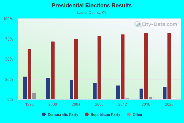
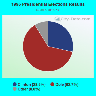
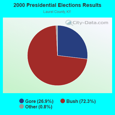
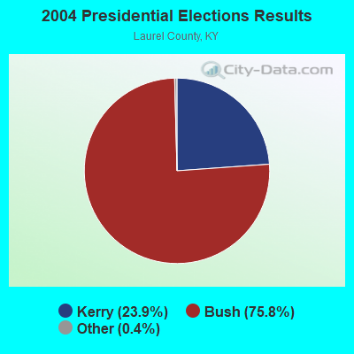
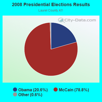
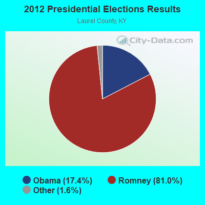

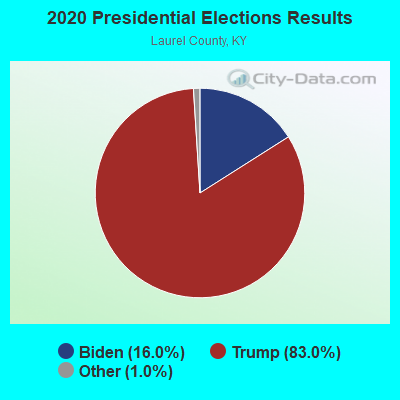
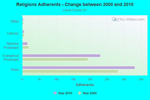
Graphs represent county-level data. Detailed 2008 Election Results
Religion statistics for Colony, KY (based on Laurel County data)
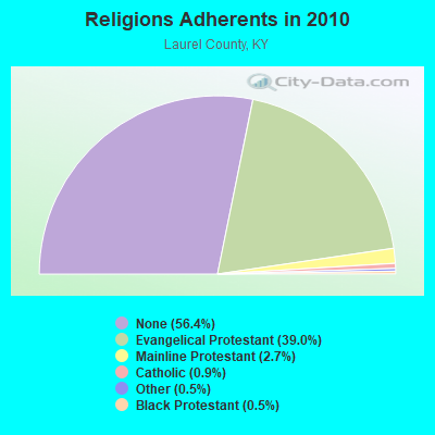
| Religion | Adherents | Congregations |
|---|---|---|
| Evangelical Protestant | 22,963 | 80 |
| Mainline Protestant | 1,579 | 8 |
| Catholic | 512 | 1 |
| Other | 309 | 2 |
| Black Protestant | 290 | 2 |
| None | 33,196 | - |
Food Environment Statistics:
| Here: | 2.79 / 10,000 pop. |
| State: | 2.19 / 10,000 pop. |
| Laurel County: | 0.35 / 10,000 pop. |
| Kentucky: | 0.25 / 10,000 pop. |
| Laurel County: | 0.17 / 10,000 pop. |
| Kentucky: | 0.74 / 10,000 pop. |
| Here: | 5.06 / 10,000 pop. |
| State: | 4.36 / 10,000 pop. |
| This county: | 5.23 / 10,000 pop. |
| Kentucky: | 5.74 / 10,000 pop. |
| Laurel County: | 13.0% |
| Kentucky: | 11.0% |
| Here: | 35.1% |
| Kentucky: | 30.0% |
| This county: | 18.5% |
| State: | 15.9% |
Strongest AM radio stations in Colony:
- WGWM (980 AM; 1 kW; LONDON, KY; Owner: WGWM BROADCASTING, INC.)
- WFTG (1400 AM; 1 kW; LONDON, KY; Owner: F.T.G. BROADCASTING, INC.)
- WKDP (1330 AM; 5 kW; CORBIN, KY; Owner: EUBANKS BROADCASTING, INC.)
- WKVL (850 AM; daytime; 50 kW; KNOXVILLE, TN; Owner: HORNE RADIO, LLC)
- WEKC (710 AM; daytime; 4 kW; WILLIAMSBURG, KY; Owner: GERALD PARKS)
- WKLB (1290 AM; 5 kW; MANCHESTER, KY; Owner: BARKER BROADCASTING COMPANY, INC.)
- WHAS (840 AM; 50 kW; LOUISVILLE, KY; Owner: CLEAR CHANNEL BROADCASTING LICENSES, INC.)
- WCTT (680 AM; 1 kW; CORBIN, KY; Owner: ENCORE COMMUNICATIONS, INC)
- WLW (700 AM; 50 kW; CINCINNATI, OH; Owner: JACOR BROADCASTING CORPORATION)
- WSM (650 AM; 50 kW; NASHVILLE, TN; Owner: GAYLORD ENTERTAINMENT COMPANY)
- WMTC (730 AM; 5 kW; VANCLEVE, KY; Owner: THE KENTUCKY MOUNTAIN HOLINESS ASSN.)
- WTVN (610 AM; 50 kW; COLUMBUS, OH; Owner: CITICASTERS LICENSES, L.P.)
- WFGW (1010 AM; 50 kW; BLACK MOUNTAIN, NC; Owner: BLUE RIDGE BROADCASTING CORP.)
Strongest FM radio stations in Colony:
- WYGE (92.3 FM; LONDON, KY; Owner: ETHEL HUFF BROADCASTING, LLC)
- WWEL (103.9 FM; LONDON, KY; Owner: F.T.G. BROADCASTING, INC.)
- WKDP-FM (99.5 FM; CORBIN, KY; Owner: EUBANKS BROADCASTING, INC.)
- WLLK (93.9 FM; BURNSIDE, KY; Owner: CAPSTAR TX LIMITED PARTNERSHIP)
- WVCT (91.5 FM; KEAVY, KY; Owner: VICTORY TRAINING SCHOOL CORP.)
- WTBK (105.7 FM; MANCHESTER, KY; Owner: MANCHESTER COMMUNICATIONS, INC.)
- WTHL (90.5 FM; SOMERSET, KY; Owner: SOMERSET EDUCATIONAL BROADCASTING FOUNDATION)
- WCTT-FM (107.3 FM; CORBIN, KY; Owner: ENCORE COMMUNICATIONS, INC.)
- WSEK (97.1 FM; SOMERSET, KY; Owner: CAPSTAR TX LIMITED PARTNERSHIP)
- WEKX (102.7 FM; JELLICO, TN; Owner: WHITLEY BROADCASTING CO., INC.)
- WMIK-FM (92.7 FM; MIDDLESBORO, KY; Owner: GATEWAY BROADCASTING, INC.)
- WWLT (103.1 FM; MANCHESTER, KY; Owner: VERNON R. BALDWIN, INC.)
- WLFX (106.7 FM; BEREA, KY; Owner: WALLINGFORD COMMUNICATIONS, LLC)
- WEZJ-FM (104.3 FM; WILLIAMSBURG, KY; Owner: WHITLEY BROADCASTING CO., INC.)
- WRIL (106.3 FM; PINEVILLE, KY; Owner: PINE HILLS BROADCASTING, INC.)
- WWAG (107.9 FM; MCKEE, KY; Owner: DANDY BROADCASTING, INC.)
- WCYO (100.7 FM; IRVINE, KY; Owner: KENTUCKY RIVER BROADCASTING CO.)
- W277AA (103.3 FM; SOMERSET, KY; Owner: WESTERN KENTUCKY UNIVERSITY)
TV broadcast stations around Colony:
- WOBZ-LP (Channel 9; EAST BERNSTADT, ETC., KY; Owner: ANDREA JOY KESLER)
- WVTN-LP (Channel 48; CORBIN, KY; Owner: VICTORY TRAINING SCHOOL CORP.)
- WKSO-TV (Channel 29; SOMERSET, KY; Owner: KENTUCKY AUTHORITY FOR EDUCATIONAL TV)
- W39CK (Channel 20; CORBIN, KY; Owner: DEREK RAY EUBANKS)
- WLJC-TV (Channel 65; BEATTYVILLE, KY; Owner: HOUR OF HARVEST, INC.)
- WBLU-LP (Channel 62; LEXINGTON, KY; Owner: SANDRA B. POWLEY)
- W33BK (Channel 33; CORBIN, KY; Owner: TRINITY BROADCASTING NETWORK)
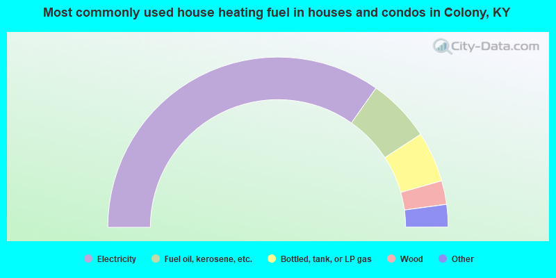
- 69.6%Electricity
- 12.1%Fuel oil, kerosene, etc.
- 9.6%Bottled, tank, or LP gas
- 4.5%Wood
- 2.0%Utility gas
- 1.5%Coal or coke
- 0.7%No fuel used
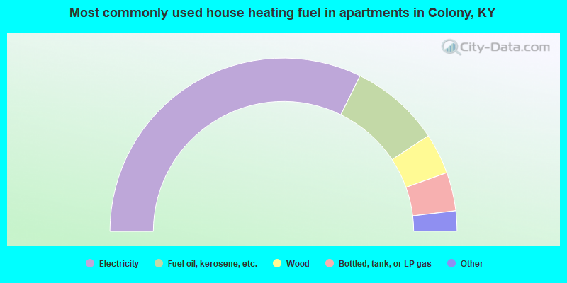
- 64.6%Electricity
- 16.9%Fuel oil, kerosene, etc.
- 7.6%Wood
- 7.2%Bottled, tank, or LP gas
- 2.1%Coal or coke
- 1.7%No fuel used
Colony compared to Kentucky state average:
- Unemployed percentage below state average.
- Black race population percentage significantly below state average.
- Hispanic race population percentage significantly below state average.
- Median age below state average.
- Foreign-born population percentage significantly below state average.
- Length of stay since moving in significantly above state average.
- Number of rooms per house significantly below state average.
- House age significantly below state average.
- Number of college students below state average.
- Percentage of population with a bachelor's degree or higher below state average.