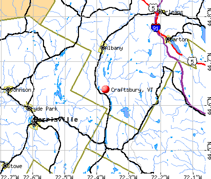
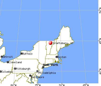
Craftsbury, Vermont
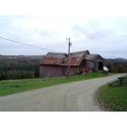
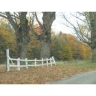
Craftsbury: Barn near Craftsbury
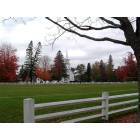
Craftsbury: Craftsbury Common
Craftsbury: Craftsbury Common
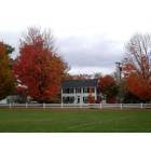
Craftsbury: Craftsbury, VT
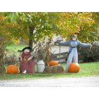
Craftsbury: Craftsbury, VT
- add
your
Submit your own pictures of this town and show them to the world
- OSM Map
- General Map
- Google Map
- MSN Map
Population change since 2000: +6.2%
 |
| Males: 594 | |
| Females: 612 |
| Median resident age: | 44.1 years |
| Vermont median age: | 45.8 years |
Zip codes: 05827.
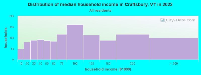
| Craftsbury: | $70,893 |
| VT: | $73,991 |
Estimated per capita income in 2022: $36,242 (it was $17,185 in 2000)
Craftsbury town income, earnings, and wages data
Estimated median house or condo value in 2022: $238,448 (it was $89,300 in 2000)
| Craftsbury: | $238,448 |
| VT: | $304,700 |
Mean prices in 2022: all housing units: $271,502; detached houses: $290,446; townhouses or other attached units: $299,602; in 2-unit structures: $159,589; in 3-to-4-unit structures: $395,771; in 5-or-more-unit structures: $253,965; mobile homes: $74,912
Detailed information about poverty and poor residents in Craftsbury, VT


- 1,15896.0%White alone
- 242.0%Hispanic
- 110.9%Two or more races
- 50.4%Asian alone
- 40.3%Other race alone
- 30.2%Black alone
- 10.08%Native Hawaiian and Other
Pacific Islander alone
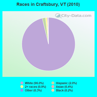
Races in Craftsbury detailed stats: ancestries, foreign born residents, place of birth
 Recent articles from our blog. Our writers, many of them Ph.D. graduates or candidates, create easy-to-read articles on a wide variety of topics.

 | Craftsbury, VT (0 replies) |
| Communities or not? (43 replies) |
| Snow In Vermont (17 replies) |
| What is up with St Johnsbury? (17 replies) |
| Considering Moving to Vermont From Arizona (40 replies) |
| VT just blew my away! (36 replies) |
Latest news from Craftsbury, VT collected exclusively by city-data.com from local newspapers, TV, and radio stations
Ancestries: English (31.4%), French (15.9%), Irish (15.0%), Scottish (11.1%), French Canadian (9.4%), German (8.0%).
Current Local Time: EST time zone
Elevation: 931 feet
Land area: 39.3 square miles.
Population density: 31 people per square mile (very low).
48 residents are foreign born (2.3% North America, 1.1% Asia, 0.6% Europe).
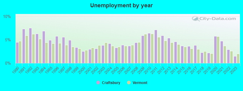
| This town: | 4.2% |
| Vermont: | 3.8% |
| Craftsbury town: | 2.0% ($1,780) |
| Vermont: | 2.0% ($2,196) |
Nearest city with pop. 50,000+: Manchester, NH  (124.5 miles , pop. 107,006).
Nearest city with pop. 200,000+: Boston, MA (174.1 miles , pop. 589,141).
Nearest city with pop. 1,000,000+: Bronx, NY (274.3 miles , pop. 1,332,650).
Nearest cities:
), ), ), ), ), )Latitude: 44.66 N, Longitude: 72.38 W
Area code: 802

| Here: | 1.5% |
| Vermont: | 2.0% |
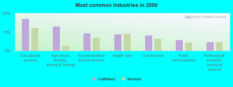
- Educational services (17.2%)
- Agriculture, forestry, fishing & hunting (13.2%)
- Accommodation & food services (9.5%)
- Health care (9.0%)
- Construction (8.4%)
- Public administration (5.9%)
- Professional, scientific, technical services (4.8%)
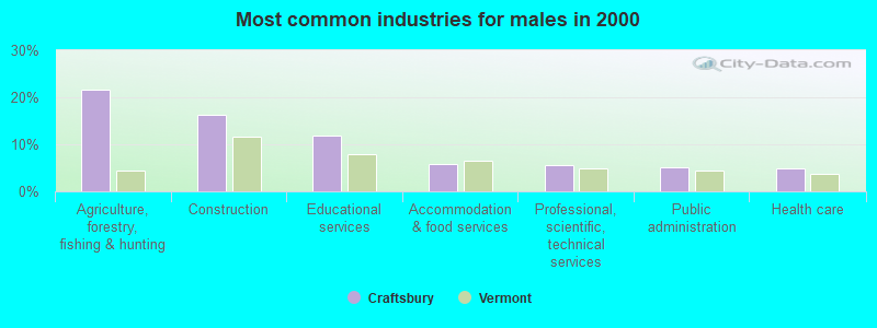
- Agriculture, forestry, fishing & hunting (21.7%)
- Construction (16.2%)
- Educational services (12.0%)
- Accommodation & food services (5.8%)
- Professional, scientific, technical services (5.5%)
- Public administration (5.2%)
- Health care (4.9%)
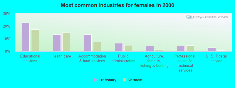
- Educational services (22.8%)
- Health care (13.5%)
- Accommodation & food services (13.5%)
- Public administration (6.6%)
- Agriculture, forestry, fishing & hunting (4.2%)
- Professional, scientific, technical services (4.2%)
- U. S. Postal service (3.1%)
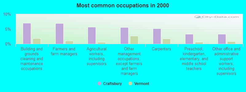
- Building and grounds cleaning and maintenance occupations (7.0%)
- Farmers and farm managers (6.9%)
- Agricultural workers, including supervisors (5.7%)
- Other management occupations, except farmers and farm managers (5.5%)
- Carpenters (5.2%)
- Preschool, kindergarten, elementary, and middle school teachers (3.3%)
- Other office and administrative support workers, including supervisors (3.3%)
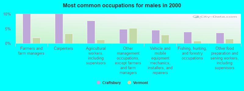
- Farmers and farm managers (10.0%)
- Carpenters (10.0%)
- Agricultural workers, including supervisors (7.8%)
- Other management occupations, except farmers and farm managers (4.9%)
- Vehicle and mobile equipment mechanics, installers, and repairers (4.5%)
- Fishing, hunting, and forestry occupations (3.9%)
- Other food preparation and serving workers, including supervisors (3.6%)
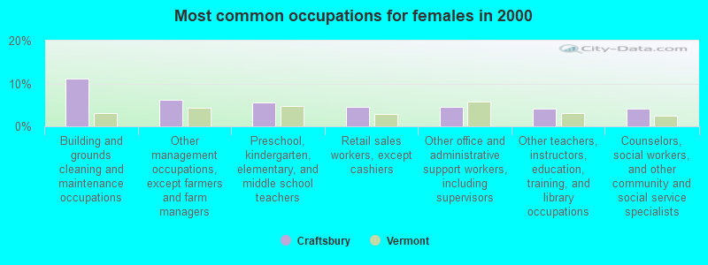
- Building and grounds cleaning and maintenance occupations (11.1%)
- Other management occupations, except farmers and farm managers (6.2%)
- Preschool, kindergarten, elementary, and middle school teachers (5.5%)
- Retail sales workers, except cashiers (4.5%)
- Other office and administrative support workers, including supervisors (4.5%)
- Other teachers, instructors, education, training, and library occupations (4.2%)
- Counselors, social workers, and other community and social service specialists (4.2%)
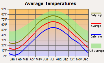
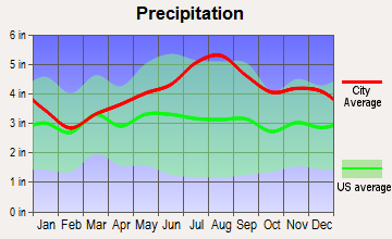
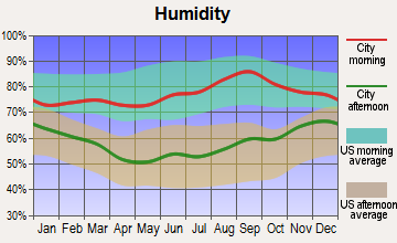
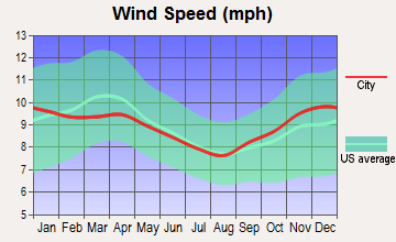
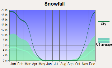
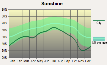
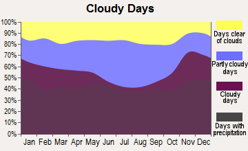
Average climate in Craftsbury, Vermont
Based on data reported by over 4,000 weather stations
Earthquake activity:
Craftsbury-area historical earthquake activity is significantly above Vermont state average. It is 73% smaller than the overall U.S. average.On 4/20/2002 at 10:50:47, a magnitude 5.3 (5.3 ML, Depth: 3.0 mi, Class: Moderate, Intensity: VI - VII) earthquake occurred 65.7 miles away from the city center
On 4/20/2002 at 10:50:47, a magnitude 5.2 (5.2 MB, 4.2 MS, 5.2 MW, 5.0 MW) earthquake occurred 67.0 miles away from the city center
On 10/7/1983 at 10:18:46, a magnitude 5.3 (5.1 MB, 5.3 LG, 5.1 ML) earthquake occurred 108.7 miles away from the city center
On 1/19/1982 at 00:14:42, a magnitude 4.7 (4.5 MB, 4.7 MD, 4.5 LG, Class: Light, Intensity: IV - V) earthquake occurred 89.0 miles away from Craftsbury center
On 10/16/2012 at 23:12:25, a magnitude 4.7 (4.7 ML, Depth: 10.0 mi) earthquake occurred 112.7 miles away from Craftsbury center
On 6/16/1995 at 12:13:11, a magnitude 3.8 (3.8 LG, Depth: 3.1 mi, Class: Light, Intensity: II - III) earthquake occurred 34.5 miles away from the city center
Magnitude types: regional Lg-wave magnitude (LG), body-wave magnitude (MB), duration magnitude (MD), local magnitude (ML), surface-wave magnitude (MS), moment magnitude (MW)
Natural disasters:
The number of natural disasters in Orleans County (23) is greater than the US average (15).Major Disasters (Presidential) Declared: 17
Emergencies Declared: 2
Causes of natural disasters: Floods: 16, Storms: 14, Tropical Storms: 2, Winds: 2, Winter Storms: 2, Heavy Rain: 1, Hurricane: 1, Landslide: 1, Snowstorm: 1, Tornado: 1, Other: 1 (Note: some incidents may be assigned to more than one category).
Hospitals and medical centers near Craftsbury:
- UNION HOUSE NURSING HOME (Nursing Home, about 9 miles away; GLOVER, VT)
- MAPLE LANE NURSING HOME (Nursing Home, about 9 miles away; BARTON, VT)
- LAMOILLE HOME HEALTH AND HOSPICE (Home Health Center, about 13 miles away; MORRISVILLE, VT)
- THE MANOR, INC (Nursing Home, about 13 miles away; MORRISVILLE, VT)
- COPLEY HOSPITAL Critical Access Hospitals (about 13 miles away; MORRISVILLE, VT)
- ELMORE HOUSE AT COPLEY MANOR (Nursing Home, about 13 miles away; MORRISVILLE, VT)
Colleges/universities with over 2000 students nearest to Craftsbury:
- Norwich University (about 39 miles; Northfield, VT; Full-time enrollment: 4,221)
- Saint Michael's College (about 41 miles; Colchester, VT; FT enrollment: 2,336)
- Community College of Vermont (about 42 miles; Winooski, VT; FT enrollment: 3,394)
- University of Vermont (about 43 miles; Burlington, VT; FT enrollment: 11,566)
- Champlain College (about 43 miles; Burlington, VT; FT enrollment: 2,623)
- SUNY College at Plattsburgh (about 54 miles; Plattsburgh, NY; FT enrollment: 5,934)
- Middlebury College (about 60 miles; Middlebury, VT; FT enrollment: 3,077)
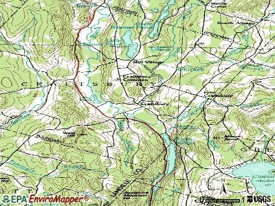
Points of interest:
Notable locations in Craftsbury: Craftsbury Nordic Center (A), John Woodruff Simpson Memorial Library (B), Craftsbury Fire Department (C). Display/hide their locations on the map
Churches in Craftsbury include: Craftsbury Common Congregational Church (A), East Craftsbury Presbyterian Church (B). Display/hide their locations on the map
Cemeteries: East Craftsbury Cemetery (1), Craftsbury Village Cemetery (2), Craftsbury Common Cemetery (3). Display/hide their locations on the map
Lakes and reservoirs: Duck Pond (A), Mud Pond (B), Little Hosmer Pond (C). Display/hide their locations on the map
Streams, rivers, and creeks: Seaver Brook (A), Seaver Branch (B), Cass Brook (C), Whitney Brook (D), Whetstone Brook (E). Display/hide their locations on the map
Park in Craftsbury: Craftsbury Common (1). Display/hide its location on the map
Hotel: Inn On The Commone (1147 North Craftsbury Rd) (1). Display/hide its approximate location on the map
Birthplace of: Roger L. Easton - Scientist, Burleigh F. Spalding - Politician.
Drinking water stations with addresses in Craftsbury and their reported violations in the past:
HOSMER POINT OUTDOOR CAMP (Address: 535 LOST NATION RD , Population served: 110, Groundwater):Past monitoring violations:CRAFTSBURY OUTDOOR CENTER (Address: 535 LOST NATION ROAD , Population served: 90, Groundwater):
- Monitoring, Repeat Major (TCR) - Between JUL-2010 and SEP-2010, Contaminant: Coliform (TCR). Follow-up actions: St Public Notif requested (NOV-02-2010), St Formal NOV issued (NOV-02-2010), St Public Notif received (JUN-09-2011), St Compliance achieved (NOV-02-2012)
- One minor monitoring violation
- One regular monitoring violation
Past health violations:CRAFTSBURY COMMUNITY CARE CENTER (Address: 1784 E CRAFTSBURY RD , Population served: 32, Groundwater):Past monitoring violations:
- MCL, Monthly (TCR) - Between JUL-2005 and SEP-2005, Contaminant: Coliform. Follow-up actions: St Violation/Reminder Notice (SEP-08-2005), St Boil Water Order (SEP-08-2005), St Tech Assistance Visit (SEP-08-2005), St Public Notif requested (SEP-08-2005), St Compliance achieved (JAN-29-2010)
- One minor monitoring violation
Past health violations:Past monitoring violations:
- MCL, Monthly (TCR) - In JUN-2007, Contaminant: Coliform. Follow-up actions: St Formal NOV issued (JUL-02-2007), St Tech Assistance Visit (JUL-02-2007), St Boil Water Order (JUL-02-2007), St Public Notif requested (JUL-02-2007), St Public Notif received (JUL-10-2007), St Compliance achieved (AUG-09-2010)
- Monitoring and Reporting (DBP) - Between JUL-2011 and SEP-2011, Contaminant: Chlorine. Follow-up actions: St Public Notif requested (FEB-02-2012), St Formal NOV issued (FEB-02-2012), St Public Notif received (FEB-16-2012), St Compliance achieved (FEB-11-2013)
- 2 routine major monitoring violations
- 12 regular monitoring violations
| This town: | 2.2 people |
| Vermont: | 2.3 people |
| This town: | 59.8% |
| Whole state: | 62.5% |
| This town: | 8.6% |
| Whole state: | 9.2% |
Likely homosexual households (counted as self-reported same-sex unmarried-partner households)
- Lesbian couples: 0.2% of all households
- Gay men: 0.4% of all households
| This town: | 13.8% |
| Whole state: | 9.4% |
| This town: | 4.4% |
| Whole state: | 3.6% |
54 people in nursing homes in 2000
44 people in college dormitories (includes college quarters off campus) in 2000
For population 15 years and over in Craftsbury:
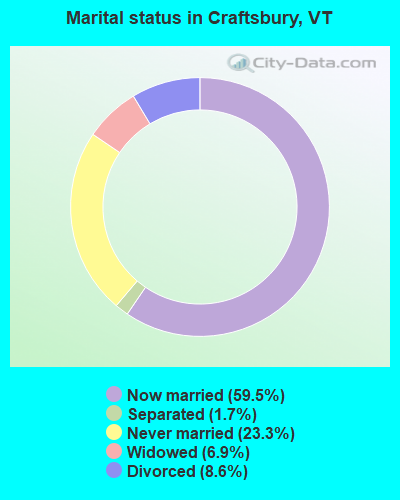
- Never married: 23.3%
- Now married: 59.5%
- Separated: 1.7%
- Widowed: 6.9%
- Divorced: 8.6%
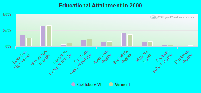
For population 25 years and over in Craftsbury:
- High school or higher: 82.3%
- Bachelor's degree or higher: 31.7%
- Graduate or professional degree: 10.8%
- Unemployed: 6.3%
- Mean travel time to work (commute): 23.8 minutes
| Here: | 13.1 |
| Vermont average: | 11.7 |
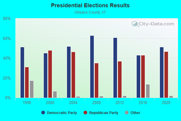
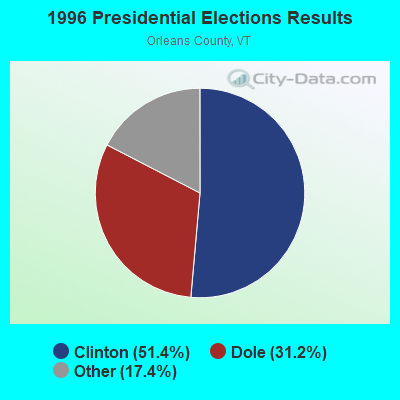
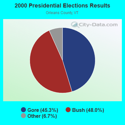
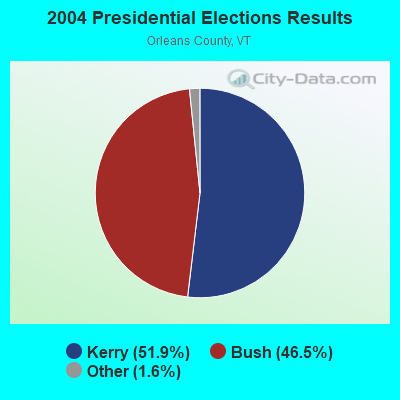
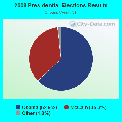
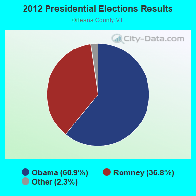
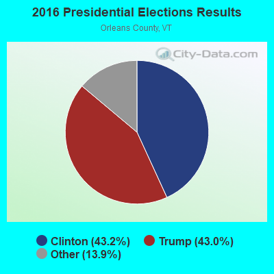
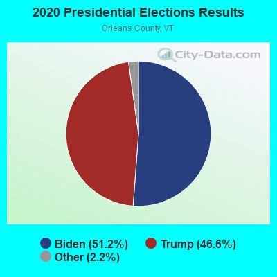
Graphs represent county-level data. Detailed 2008 Election Results
Religion statistics for Craftsbury, VT (based on Orleans County data)
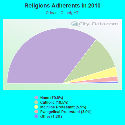
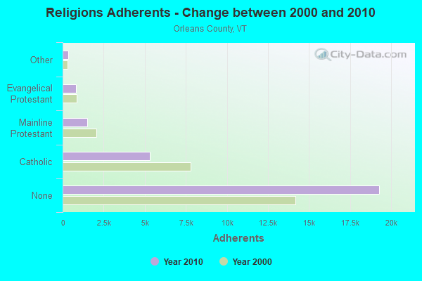
| Religion | Adherents | Congregations |
|---|---|---|
| Catholic | 5,312 | 12 |
| Mainline Protestant | 1,485 | 23 |
| Evangelical Protestant | 822 | 14 |
| Other | 323 | 4 |
| None | 19,289 | - |
Food Environment Statistics:
| This county: | 5.14 / 10,000 pop. |
| Vermont: | 3.84 / 10,000 pop. |
| Orleans County: | 1.10 / 10,000 pop. |
| Vermont: | 1.95 / 10,000 pop. |
| This county: | 6.60 / 10,000 pop. |
| Vermont: | 6.40 / 10,000 pop. |
| Orleans County: | 8.07 / 10,000 pop. |
| Vermont: | 11.52 / 10,000 pop. |
| Orleans County: | 7.0% |
| Vermont: | 6.8% |
| Here: | 24.8% |
| Vermont: | 22.3% |
| This county: | 10.8% |
| Vermont: | 13.3% |
Strongest AM radio stations in Craftsbury:
- WCHP (760 AM; 35 kW; CHAMPLAIN, NY; Owner: CHAMPLAIN RADIO, INC.)
- WDEV (550 AM; 5 kW; WATERBURY, VT; Owner: RADIO VERMONT, INC.)
- WVMT (620 AM; 5 kW; BURLINGTON, VT; Owner: SISON BROADCASTING, INC.)
- WICY (1490 AM; 50 kW; MALONE, NY; Owner: CARTIER COMMUNICATIONS INC.)
- WTWN (1100 AM; daytime; 5 kW; WELLS RIVER, VT; Owner: PUFFER BROADCASTING, INC.)
- WRKO (680 AM; 50 kW; BOSTON, MA; Owner: ENTERCOM BOSTON LICENSE, LLC)
- WGY (810 AM; 50 kW; SCHENECTADY, NY; Owner: CLEAR CHANNEL BROADCASTING LICENSES, INC.)
- WNNZ (640 AM; 50 kW; WESTFIELD, MA; Owner: CLEAR CHANNEL BROADCASTING LICENSES, INC.)
- WCRN (830 AM; 50 kW; WORCESTER, MA; Owner: CARTER BROADCASTING CORPORATION)
- WVAA (1390 AM; 5 kW; BURLINGTON, VT; Owner: RADIO VERMONT, KDR, LLC)
- WEEI (850 AM; 50 kW; BOSTON, MA; Owner: ENTERCOM BOSTON LICENSE, LLC)
- WEAV (960 AM; 5 kW; PLATTSBURGH, NY; Owner: CLEAR CHANNEL BROADCASTING LICENSES, INC.)
- WTWK (1070 AM; daytime; 5 kW; PLATTSBURGH, NY; Owner: CHAMPLAIN COMMUNICATIONS CORPORATION)
Strongest FM radio stations in Craftsbury:
- WLKC (103.3 FM; WATERBURY, VT; Owner: RADIO BROADCASTING SERVICES, INC.)
- WEZF (92.9 FM; BURLINGTON, VT; Owner: CAPSTAR TX LIMITED PARTNERSHIP)
- WVPS (107.9 FM; BURLINGTON, VT; Owner: VERMONT PUBLIC RADIO)
- WCVT (101.7 FM; STOWE, VT; Owner: RADIO VERMONT CLASSICS, L.L.C.)
- WNCS (104.7 FM; MONTPELIER, VT; Owner: MONTPELIER BROADCASTING, INC.)
- WGMT (97.7 FM; LYNDON, VT; Owner: VERMONT BROADCAST ASSOCIATES, INC.)
- WDOT (95.7 FM; DANVILLE, VT; Owner: MONTPELIER BROADCASTING INC)
- W243AE (96.5 FM; ORLEANS, VT; Owner: CHRISTIAN MINISTRIES, INC.)
- WPKQ (103.7 FM; NORTH CONWAY, NH; Owner: CITADEL BROADCASTING COMPANY)
- WHOM (94.9 FM; MT. WASHINGTON, NH; Owner: CITADEL BROADCASTING COMPANY)
- WDEV-FM (96.1 FM; WARREN, VT; Owner: RADIO VERMONT, INC.)
- WMTK (106.3 FM; LITTLETON, NH; Owner: VERMONT BROADCAST ASSOCIATES, INC.)
- WCKJ (90.5 FM; ST. JOHNSBURY, VT; Owner: CHRISTIAN MINISTRIES, INC.)
- WCEL (91.9 FM; PLATTSBURGH, NY; Owner: WAMC)
- WKXH (105.5 FM; ST. JOHNSBURY, VT; Owner: VERMONT BROADCAST ASSOCIATES, INC.)
- WGLY-FM (91.5 FM; BOLTON, VT; Owner: CHRISTIAN MINISTRIES, INC.)
- WVFM (105.7 FM; CAMPTON, NH; Owner: DEVON BROADCASTING COMPANY, INC.)
- WMOO (92.1 FM; DERBY CENTER, VT; Owner: NORTHSTAR MEDIA, INC.)
- WLFE-FM (102.3 FM; ST. ALBANS, VT; Owner: CHAMPLAIN COMMUNICATIONS CORP.)
- WXXS (102.3 FM; LANCASTER, NH; Owner: BARRY P. LUNDERVILLE)
TV broadcast stations around Craftsbury:
- WVNY (Channel 22; BURLINGTON, VT; Owner: C-22 FCC LICENSEE SUBSIDIARY, LLC)
Craftsbury fatal accident list:
Sep 22, 1983 02:35 PM, Vt14, Vehicles: 2, Persons: 2, Fatalities: 1
Jul 25, 1981 08:00 AM, Vehicles: 2, Persons: 7, Fatalities: 1, Drunk persons involved: 1
Jul 18, 1978 87:99 PM, Vehicles: 1, Persons: 1, Fatalities: 1, Drunk persons involved: 1
- National Bridge Inventory (NBI) Statistics
- 17Number of bridges
- 82ft / 24.7mTotal length
- $2,243,000Total costs
- 7,074Total average daily traffic
- 342Total average daily truck traffic
- 7,433Total future (year 2026) average daily traffic
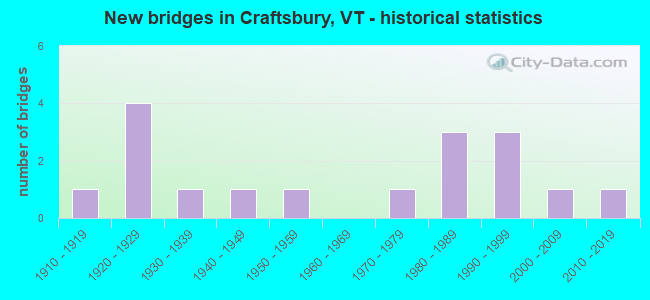
- New bridges - historical statistics
- 11910-1919
- 41920-1929
- 11930-1939
- 11940-1949
- 11950-1959
- 11970-1979
- 31980-1989
- 31990-1999
- 12000-2009
- 12010-2019
FCC Registered Broadcast Land Mobile Towers:
2- 1422 N Craftsbury Rd (Lat: 44.654194 Lon: -72.381972), Type: Building, Structure height: 9 m, Call Sign: WQMZ953,
Assigned Frequencies: 462.750 MHz, Grant Date: 11/19/2010, Expiration Date: 11/19/2020, Cancellation Date: 01/23/2021, Certifier: Dylan Laflam, Registrant: Visiplex, Inc., 100 N Fairway Drive, Suite 120, Vernon Hills, IL 60061, Phone: (847) 918-0250, Fax: (847) 918-0259, Email:
- Lat: 44.622639 Lon: -72.413722, Call Sign: WQOL863,
Assigned Frequencies: 152.930 MHz, Grant Date: 11/10/2011, Expiration Date: 11/10/2021, Cancellation Date: 01/15/2022, Certifier: Dwight Denton, Registrant: Burlington Communication Service Center, 4735 Williston Rd Ste 30, Williston, VT 05495-5333, Phone: (802) 862-7092, Fax: (802) 860-6178, Email:
FCC Registered Amateur Radio Licenses:
3- Call Sign: KA2QPT, Licensee ID: L01016791, Grant Date: 12/16/2015, Expiration Date: 03/14/2026, Certifier: Cornelius M Ulman, Registrant: Cornelius M Ulman, 662 Guy Lot Road, Craftsbury, VT 05826
- Call Sign: N1WFQ, Grant Date: 02/26/1996, Expiration Date: 11/30/2005, Cancellation Date: 12/01/2007, Registrant: David L Briars, Rd 1 Box 45 Creek Rd, Craftsbury, VT 05826
- Call Sign: KC1NJB, Licensee ID: L02355946, Grant Date: 06/26/2020, Expiration Date: 06/26/2030, Certifier: Alton J Daniels, Registrant: Alton J Daniels, 26 South Albany Road Apt B, Craftsbury, VT 05826
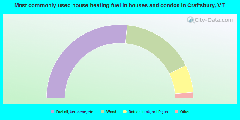
- 53.1%Fuel oil, kerosene, etc.
- 32.2%Wood
- 12.1%Bottled, tank, or LP gas
- 0.8%Electricity
- 0.8%Coal or coke
- 0.8%Solar energy
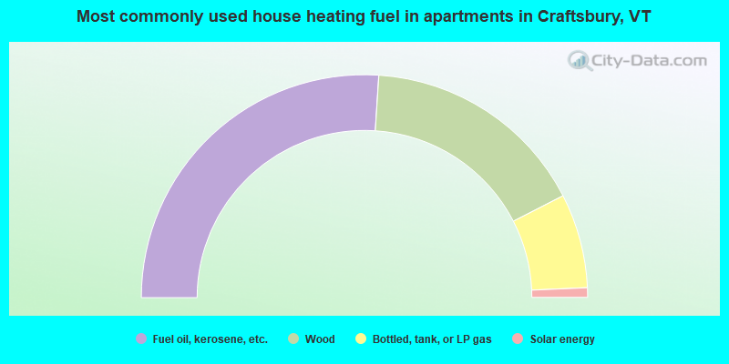
- 52.1%Fuel oil, kerosene, etc.
- 32.9%Wood
- 13.7%Bottled, tank, or LP gas
- 1.4%Solar energy
Craftsbury compared to Vermont state average:
- Unemployed percentage below state average.
- Black race population percentage significantly below state average.
- Renting percentage below state average.
- Length of stay since moving in significantly above state average.
- Number of rooms per house significantly below state average.
- House age significantly below state average.
- Institutionalized population percentage significantly above state average.

|
Total of 2 patent applications in 2008-2024.