District 1, Buckeystown, Maryland

Submit your own pictures of this city and show them to the world
- OSM Map
- General Map
- Google Map
- MSN Map

| Males: 3,567 | |
| Females: 3,586 |
| Median resident age: | 34.8 years |
| Maryland median age: | 36.0 years |
Zip code: 21710
| District 1, Buckeystown: | $132,604 |
| MD: | $94,991 |
Estimated per capita income in 2022: $51,321 (it was $24,584 in 2000)
District 1, Buckeystown income, earnings, and wages data
Estimated median house or condo value in 2022: $445,515 (it was $158,200 in 2000)
| District 1, Buckeystown: | $445,515 |
| MD: | $398,100 |
Mean prices in 2022: all housing units: $523,284; detached houses: $575,676; townhouses or other attached units: $390,501; in 2-unit structures: $340,938; in 3-to-4-unit structures: $324,226; in 5-or-more-unit structures: $258,566; mobile homes: $221,205
District 1, Buckeystown, MD residents, houses, and apartments details
Detailed information about poverty and poor residents in District 1, Buckeystown, MD


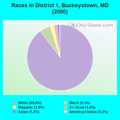
- 5,61489.8%White alone
- 3305.3%Black alone
- 1171.9%Hispanic
- 971.6%Two or more races
- 761.2%Asian alone
- 120.2%American Indian alone
- 30.05%Other race alone
Races in District 1, Buckeystown detailed stats: ancestries, foreign born residents, place of birth
 Recent articles from our blog. Our writers, many of them Ph.D. graduates or candidates, create easy-to-read articles on a wide variety of topics.
Current Local Time: EST time zone
Land area: 40.3 square miles.
Population density: 178 people per square mile (very low).

| District 1, Buckeystown: | 0.9% ($1,387) |
| Maryland: | 1.2% ($1,782) |
Nearest city with pop. 50,000+: Frederick, MD  (9.0 miles , pop. 52,767).
Nearest city with pop. 200,000+: Washington, DC (36.8 miles , pop. 572,059).
Nearest city with pop. 1,000,000+: Philadelphia, PA (133.2 miles , pop. 1,517,550).
Nearest cities:
), ), ), ), ), ), )Latitude: 39.30 N, Longitude: 77.48 W

| Here: | 1.9% |
| Maryland: | 2.0% |
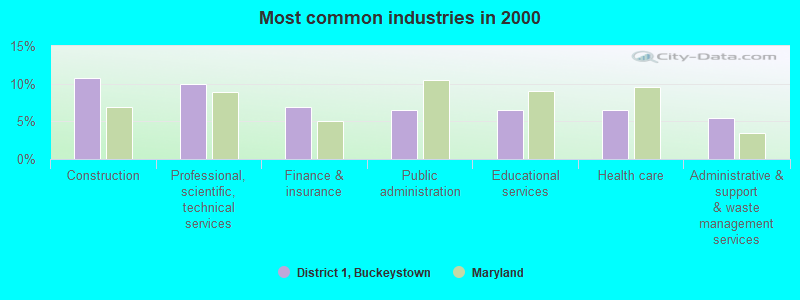
- Construction (10.8%)
- Professional, scientific, technical services (10.0%)
- Finance & insurance (6.9%)
- Public administration (6.6%)
- Educational services (6.6%)
- Health care (6.6%)
- Administrative & support & waste management services (5.5%)
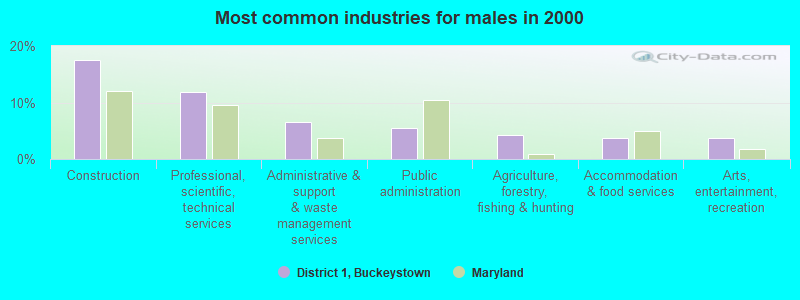
- Construction (17.6%)
- Professional, scientific, technical services (11.8%)
- Administrative & support & waste management services (6.5%)
- Public administration (5.5%)
- Agriculture, forestry, fishing & hunting (4.3%)
- Accommodation & food services (3.8%)
- Arts, entertainment, recreation (3.8%)
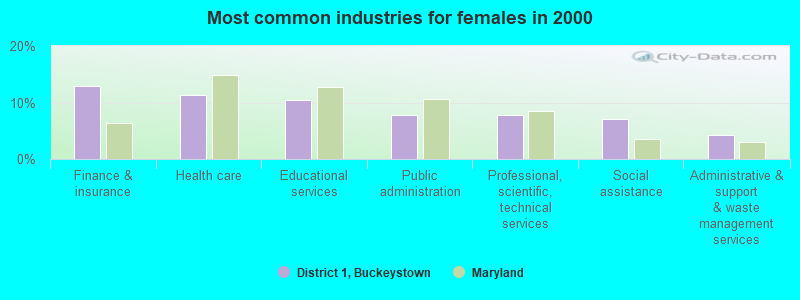
- Finance & insurance (12.9%)
- Health care (11.3%)
- Educational services (10.5%)
- Public administration (7.8%)
- Professional, scientific, technical services (7.8%)
- Social assistance (7.1%)
- Administrative & support & waste management services (4.2%)
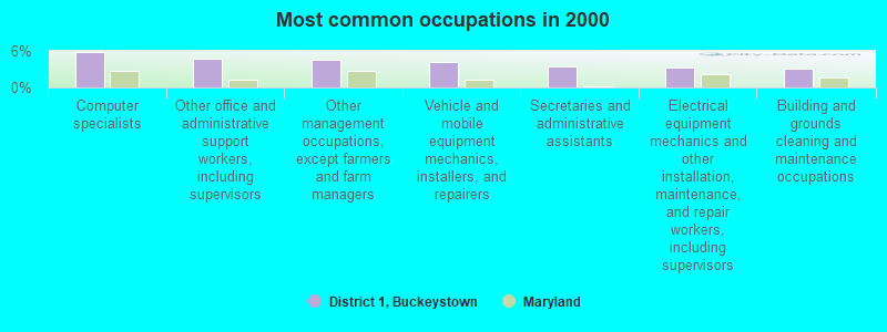
- Computer specialists (5.8%)
- Other office and administrative support workers, including supervisors (4.8%)
- Other management occupations, except farmers and farm managers (4.5%)
- Vehicle and mobile equipment mechanics, installers, and repairers (4.3%)
- Secretaries and administrative assistants (3.4%)
- Electrical equipment mechanics and other installation, maintenance, and repair workers, including supervisors (3.3%)
- Building and grounds cleaning and maintenance occupations (3.2%)
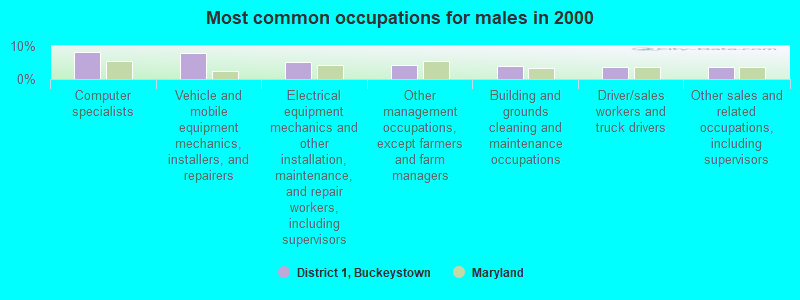
- Computer specialists (8.2%)
- Vehicle and mobile equipment mechanics, installers, and repairers (7.8%)
- Electrical equipment mechanics and other installation, maintenance, and repair workers, including supervisors (5.2%)
- Other management occupations, except farmers and farm managers (4.3%)
- Building and grounds cleaning and maintenance occupations (3.9%)
- Driver/sales workers and truck drivers (3.8%)
- Other sales and related occupations, including supervisors (3.7%)
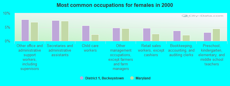
- Other office and administrative support workers, including supervisors (7.7%)
- Secretaries and administrative assistants (7.4%)
- Child care workers (5.6%)
- Other management occupations, except farmers and farm managers (4.8%)
- Retail sales workers, except cashiers (4.6%)
- Bookkeeping, accounting, and auditing clerks (3.7%)
- Preschool, kindergarten, elementary, and middle school teachers (3.1%)
Average climate in District 1, Buckeystown, Maryland
Based on data reported by over 4,000 weather stations


(lower is better)
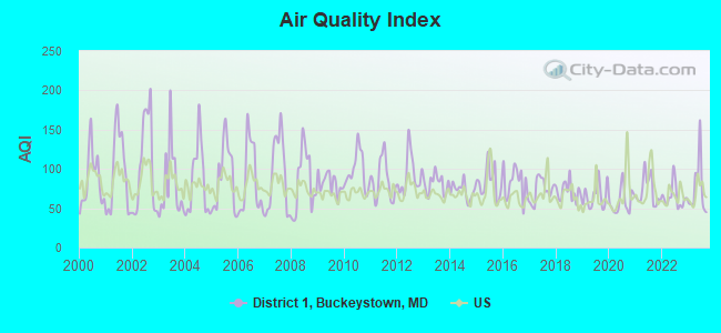
Air Quality Index (AQI) level in 2023 was 74.6. This is about average.
| City: | 74.6 |
| U.S.: | 72.6 |
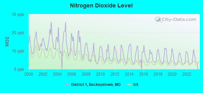
Nitrogen Dioxide (NO2) [ppb] level in 2022 was 5.49. This is about average. Closest monitor was 0.8 miles away from the city center.
| City: | 5.49 |
| U.S.: | 5.11 |
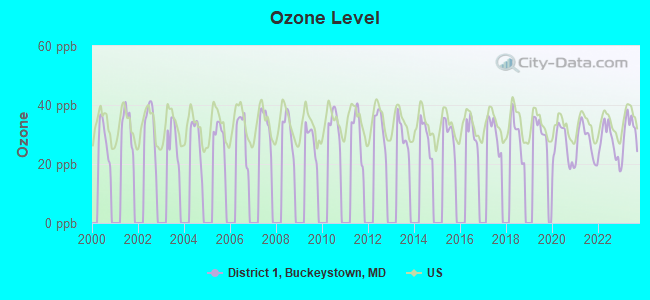
Ozone [ppb] level in 2023 was 31.0. This is about average. Closest monitor was 9.9 miles away from the city center.
| City: | 31.0 |
| U.S.: | 33.3 |
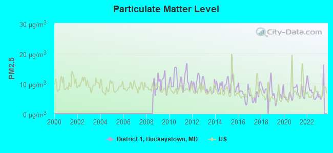
Particulate Matter (PM2.5) [µg/m3] level in 2022 was 7.41. This is about average. Closest monitor was 19.3 miles away from the city center.
| City: | 7.41 |
| U.S.: | 8.11 |
Tornado activity:
District 1, Buckeystown-area historical tornado activity is slightly above Maryland state average. It is 6% greater than the overall U.S. average.
On 9/5/1979, a category F3 (max. wind speeds 158-206 mph) tornado 23.8 miles away from the District 1, Buckeystown city center killed one person and injured 6 people and caused between $500,000 and $5,000,000 in damages.
On 9/24/2001, a category F4 (max. wind speeds 207-260 mph) tornado 44.6 miles away from the city center injured 2 people and caused $2 million in damages.
Earthquake activity:
District 1, Buckeystown-area historical earthquake activity is significantly above Maryland state average. It is 55% smaller than the overall U.S. average.On 8/23/2011 at 17:51:04, a magnitude 5.8 (5.8 MW, Depth: 3.7 mi, Class: Moderate, Intensity: VI - VII) earthquake occurred 99.6 miles away from the city center
On 9/25/1998 at 19:52:52, a magnitude 5.2 (4.8 MB, 4.3 MS, 5.2 LG, 4.5 MW, Depth: 3.1 mi) earthquake occurred 215.6 miles away from the city center
On 1/16/1994 at 01:49:16, a magnitude 4.6 (4.6 MB, 4.6 LG, Depth: 3.1 mi, Class: Light, Intensity: IV - V) earthquake occurred 104.4 miles away from the city center
On 8/25/2011 at 05:07:52, a magnitude 4.5 (4.5 ML, Depth: 4.2 mi) earthquake occurred 97.5 miles away from the city center
On 12/9/2003 at 20:59:18, a magnitude 4.5 (4.5 ML, Depth: 6.2 mi) earthquake occurred 111.1 miles away from District 1, Buckeystown center
On 12/9/2003 at 20:59:14, a magnitude 4.5 (4.5 MB, 4.5 LG) earthquake occurred 121.0 miles away from the city center
Magnitude types: regional Lg-wave magnitude (LG), body-wave magnitude (MB), local magnitude (ML), surface-wave magnitude (MS), moment magnitude (MW)
Natural disasters:
The number of natural disasters in Frederick County (21) is greater than the US average (15).Major Disasters (Presidential) Declared: 15
Emergencies Declared: 5
Causes of natural disasters: Floods: 6, Hurricanes: 6, Storms: 5, Winter Storms: 5, Snowstorms: 3, Blizzard: 1, Heavy Rain: 1, Ice Storm: 1, Snowfall: 1, Tornado: 1, Tropical Storm: 1, Other: 1 (Note: some incidents may be assigned to more than one category).
Hospitals and medical centers near District 1, Buckeystown:
- BUCKINGHAM'S CHOICE (Nursing Home, about 3 miles away; ADAMSTOWN, MD)
- GOLDEN LIVING CENTER - FREDERICK (Nursing Home, about 8 miles away; FREDERICK, MD)
- VINDOBONA NURSING HOME (Nursing Home, about 9 miles away; BRADDOCK HEIGHTS, MD)
- HOMEWOOD RETIREMENT CTR (Nursing Home, about 9 miles away; FREDERICK, MD)
- HOSPICE OF FREDERICK COUNTY (Hospital, about 9 miles away; FREDERICK, MD)
- FREDERICK MEMORIAL HOSP HHA (Home Health Center, about 9 miles away; FREDERICK, MD)
- CATOCIN DIALYSIS (Dialysis Facility, about 9 miles away; FREDERICK, MD)
Amtrak stations near District 1, Buckeystown:
- 9 miles: FREDERICK (GREYHOUND STA., 27 E. ALL SAINTS ST.) - Bus Station . Services: fully wheelchair accessible, enclosed waiting area, public restrooms, public payphones, full-service food facilities, free short-term parking, free long-term parking, call for taxi service, intercity bus service.
- 14 miles: HARPERS FERRY (POTOMAC ST.) . Services: enclosed waiting area, public restrooms, public payphones, free short-term parking, free long-term parking, public transit connection.
Colleges/universities with over 2000 students nearest to District 1, Buckeystown:
- Frederick Community College (about 11 miles; Frederick, MD; Full-time enrollment: 3,798)
- Shepherd University (about 20 miles; Shepherdstown, WV; FT enrollment: 3,745)
- American Public University System (about 21 miles; Charles Town, WV; FT enrollment: 43,829)
- Montgomery College (about 23 miles; Rockville, MD; FT enrollment: 17,999)
- Hagerstown Community College (about 25 miles; Hagerstown, MD; FT enrollment: 3,220)
- Mount St Mary's University (about 27 miles; Emmitsburg, MD; FT enrollment: 2,313)
- Carroll Community College (about 31 miles; Westminster, MD; FT enrollment: 2,682)
Points of interest:
Notable locations in District 1, Buckeystown: Indian Town Landing (A), Dudrow Industrial Park (B), Camp Kanawha (C), Calico Rocks Campground (D), Bowmans Plains Industrial Park (E), Hedgeapple Farm (F), Rocky Point Farm (G), Tuscarora Station (H), Wedgewood Business Park (I), Sunny Side Industrial Park (J), Standford Industrial Park (K), Potomac Farms (L), Point of Rocks Industrial Park (M), Mullinix Agro Park (N), McKinney Industrial Park (O), Germantown Police Department District 5 (P), Carroll Manor Fire Company 14 (Q), Potomac Farms Nursery and Greenhouses (R), Point of Rocks Railroad Station (S), Frederick County Volunteer Fire and Rescue Station 28 Carroll Manor - Point of Rocks Station (T). Display/hide their locations on the map
Churches in District 1, Buckeystown include: Forest Grove Church (A), Buckeystown United Methodist Church (B), Point of Rocks Assembly of God Church (C), Trinity Evangelical and Reformed Church (D), Saint Josephs Carrollton Manor (E), Saint Matthews Church (F). Display/hide their locations on the map
Cemeteries: Saint Matthews Cemetery (1), Saint Josephs Carrollton Manor Cemetery (2). Display/hide their locations on the map
Streams, rivers, and creeks: Ballenger Creek (A), Kiln Run (B), Rocky Fountain Run (C), Hatchery Run (D), Washington Run (E), Doubs Branch (F), Claggett Run (G), Tuscarora Creek (H), Horsehead Run (I). Display/hide their locations on the map
Parks in District 1, Buckeystown include: Point of Rocks Community Park (1), Heaters Island Wildlife Management Area (2), Buckeystown Historic District (3), Buckeystown Community Park (4). Display/hide their locations on the map
| This city: | 2.9 people |
| Maryland: | 2.6 people |
| This city: | 74.7% |
| Whole state: | 67.1% |
| This city: | 5.6% |
| Whole state: | 6.4% |
Likely homosexual households (counted as self-reported same-sex unmarried-partner households)
- Lesbian couples: 0.5% of all households
- Gay men: 0.4% of all households
| This city: | 6.8% |
| Whole state: | 8.5% |
| This city: | 3.7% |
| Whole state: | 4.2% |
19 people in workers' group living quarters and job corps centers in 2010
17 people in nursing homes in 2000
6 people in religious group quarters in 2000
For population 15 years and over in District 1, Buckeystown:
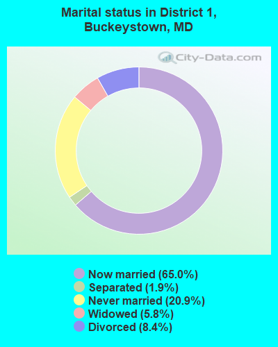
- Never married: 20.9%
- Now married: 65.0%
- Separated: 1.9%
- Widowed: 5.8%
- Divorced: 8.4%
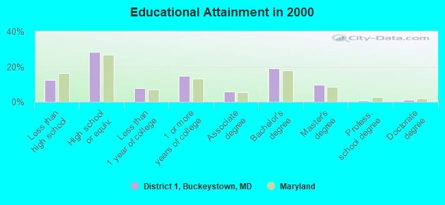
For population 25 years and over in District 1, Buckeystown:
- High school or higher: 87.4%
- Bachelor's degree or higher: 30.9%
- Graduate or professional degree: 11.8%
- Unemployed: 1.5%
- Mean travel time to work (commute): 32.3 minutes
| Here: | 10.3 |
| Maryland average: | 12.7 |
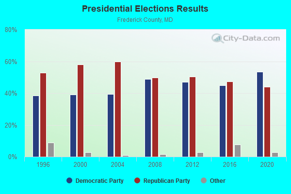
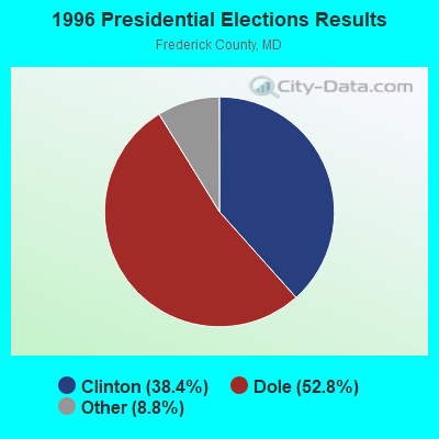
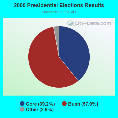
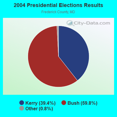
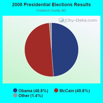
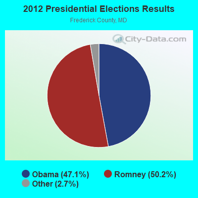
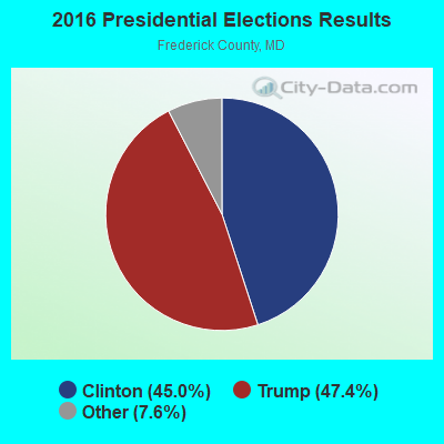
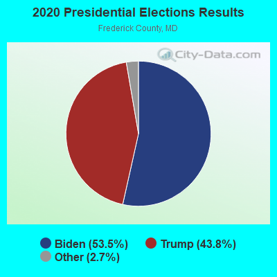
Graphs represent county-level data. Detailed 2008 Election Results
Religion statistics for District 1, Buckeystown, MD (based on Frederick County data)
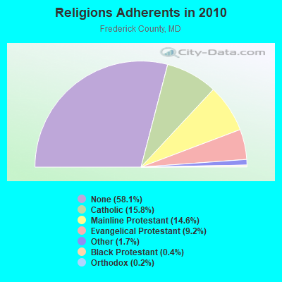
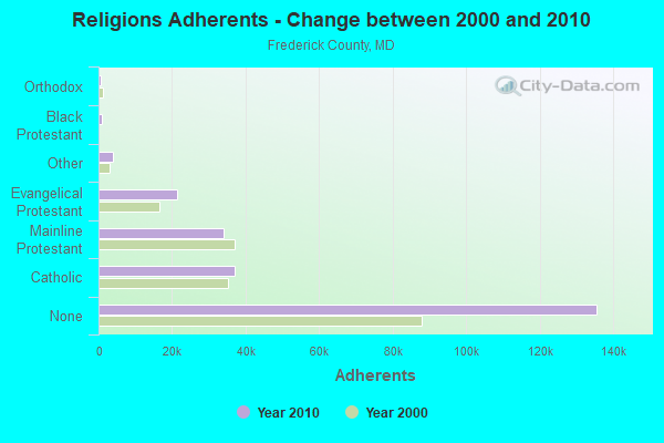
| Religion | Adherents | Congregations |
|---|---|---|
| Catholic | 36,923 | 12 |
| Mainline Protestant | 34,107 | 110 |
| Evangelical Protestant | 21,401 | 113 |
| Other | 3,901 | 19 |
| Black Protestant | 931 | 5 |
| Orthodox | 545 | 2 |
| None | 135,577 | - |
Food Environment Statistics:
| Frederick County: | 1.65 / 10,000 pop. |
| Maryland: | 1.96 / 10,000 pop. |
| This county: | 0.09 / 10,000 pop. |
| Maryland: | 0.07 / 10,000 pop. |
| Frederick County: | 0.94 / 10,000 pop. |
| Maryland: | 1.22 / 10,000 pop. |
| Frederick County: | 2.14 / 10,000 pop. |
| State: | 2.05 / 10,000 pop. |
| Frederick County: | 5.62 / 10,000 pop. |
| Maryland: | 5.40 / 10,000 pop. |
| This county: | 7.8% |
| Maryland: | 9.1% |
| This county: | 26.4% |
| Maryland: | 26.7% |
| This county: | 17.5% |
| State: | 15.5% |
8.94% of this county's 2021 resident taxpayers lived in other counties in 2020 ($83,001 average adjusted gross income)
| Here: | 8.94% |
| Maryland average: | 7.42% |
0.06% of residents moved from foreign countries ($513 average AGI)
Frederick County: 0.06% Maryland average: 0.05%
Top counties from which taxpayers relocated into this county between 2020 and 2021:
| from Montgomery County, MD | |
| from Howard County, MD | |
| from Washington County, MD |
7.01% of this county's 2020 resident taxpayers moved to other counties in 2021 ($77,350 average adjusted gross income)
| Here: | 7.01% |
| Maryland average: | 7.91% |
0.03% of residents moved to foreign countries ($420 average AGI)
Frederick County: 0.03% Maryland average: 0.04%
Top counties to which taxpayers relocated from this county between 2020 and 2021:
| to Washington County, MD | |
| to Montgomery County, MD | |
| to Carroll County, MD |
Strongest AM radio stations in District 1, Buckeystown:
- WTRI (1520 AM; daytime; 17 kW; BRUNSWICK, MD; Owner: JMK COMMUNICATIONS, INC.)
- WMET (1150 AM; 50 kW; GAITHERSBURG, MD; Owner: BELTWAY ACQUISITION CORPORATION)
- WXTR (820 AM; 4 kW; FREDERICK, MD; Owner: BONNEVILLE HOLDING COMPANY)
- WFMD (930 AM; 5 kW; FREDERICK, MD; Owner: CAPSTAR TX LIMITED PARTNERSHIP)
- WCBM (680 AM; 50 kW; BALTIMORE, MD; Owner: WCBM MARYLAND, INC.)
- WTOP (1500 AM; 50 kW; WASHINGTON, DC; Owner: BONNEVILLE HOLDING COMPANY)
- WTEM (980 AM; 50 kW; WASHINGTON, DC; Owner: AMFM RADIO LICENSES, L.L.C.)
- WBAL (1090 AM; 50 kW; BALTIMORE, MD; Owner: HEARST RADIO, INC.)
- WGOP (700 AM; daytime; 25 kW; WALKERSVILLE, MD; Owner: BIRACH BROADCASTING CORPORATION)
- WKCW (1420 AM; 50 kW; WARRENTON, VA; Owner: WAY BROADCASTING, INC.)
- WAGE (1200 AM; 5 kW; LEESBURG, VA; Owner: RADIO WAGE, INC.)
- WPGC (1580 AM; 50 kW; MORNINGSIDE, MD; Owner: INFINITY WPGC(AM), INC.)
- WUST (1120 AM; daytime; 20 kW; WASHINGTON, DC)
Strongest FM radio stations in District 1, Buckeystown:
- WAFY (103.1 FM; MIDDLETOWN, MD; Owner: FREDERICK BROADCASTING LLC)
- WWVZ (103.9 FM; BRADDOCK HEIGHTS, MD; Owner: BONNEVILLE HOLDING COMPANY)
- W219BX (91.7 FM; FREDERICK, MD; Owner: CEDAR RIDGE CHILDREN'S HOME & SCHOOL, INC)
- WFRE (99.9 FM; FREDERICK, MD; Owner: CAPSTAR TX LIMITED PARTNERSHIP)
- WARX (106.9 FM; HAGERSTOWN, MD; Owner: MANNING BROADCASTING INC.)
- WAYZ-FM (104.7 FM; HAGERSTOWN, MD; Owner: HJV LIMITED PARTNERSHIP)
- WETH (89.1 FM; HAGERSTOWN, MD; Owner: GREATER WASHINGTON EDUCATIONAL TELECOMMUNICATIONS ASSN.)
- W228BA (93.5 FM; LEESBURG, VA; Owner: CSN INTERNATIONAL)
- WINC-FM (92.5 FM; WINCHESTER, VA; Owner: MID ATLANTIC NETWORK, INC.)
- WLTF (97.5 FM; MARTINSBURG, WV; Owner: PRETTYMAN BROADCASTING COMPANY)
- W219BE (91.7 FM; WAYNESBORO, PA; Owner: MARANATHA BIBLE INSTITUTE, NDBA)
- WEEO-FM (103.7 FM; MCCONNELLSBURG, PA; Owner: ALLEGHENY MOUNTAIN NETWORK)
- WARW (94.7 FM; BETHESDA, MD; Owner: INFINITY BROADCASTING OPERATIONS, INC.)
- WWDC-FM (101.1 FM; WASHINGTON, DC; Owner: AMFM RADIO LICENSES, L.L.C.)
- WRQX (107.3 FM; WASHINGTON, DC; Owner: WMAL, INC.)
- WASH (97.1 FM; WASHINGTON, DC; Owner: AMFM RADIO LICENSES, L.L.C.)
- WWMX (106.5 FM; BALTIMORE, MD; Owner: INFINITY RADIO OPERATIONS INC.)
- WIHT (99.5 FM; WASHINGTON, DC; Owner: AMFM RADIO LICENSES, L.L.C.)
- WHUR-FM (96.3 FM; WASHINGTON, DC; Owner: THE HOWARD UNIVERSITY)
- WCRH (90.5 FM; WILLIAMSPORT, MD; Owner: CEDAR RIDGE CHILDREN'S HOME & SCHOOL, INC)
TV broadcast stations around District 1, Buckeystown:
- W52AS (Channel 52; FREDERICK, MD; Owner: THREE ANGELS BROADCASTING NETWORK)
- WFPT (Channel 62; FREDERICK, MD; Owner: MARYLAND PUBLIC BROADCASTING COMMISSION)
- WTTG (Channel 5; WASHINGTON, DC; Owner: FOX TELEVISION STATIONS, INC.)
- WMPB (Channel 67; BALTIMORE, MD; Owner: MARYLAND PUBLIC BROADCASTING COMMISSION)
- WJLA-TV (Channel 7; WASHINGTON, DC; Owner: ACC LICENSEE, INC.)
- WUSA (Channel 9; WASHINGTON, DC; Owner: THE DETROIT NEWS, INC.)
- WBAL-TV (Channel 11; BALTIMORE, MD; Owner: WBAL HEARST-ARGYLE TV, INC. (CA CORP.))
- WBFF (Channel 45; BALTIMORE, MD; Owner: CHESAPEAKE TELEVISION LICENSEE, LLC)
- WETA-TV (Channel 26; WASHINGTON, DC; Owner: THE GREATER WASHINGTON ED TELECOMM. ASSOC)
- WNUV (Channel 54; BALTIMORE, MD; Owner: BALTIMORE (WNUV-TV) LICENSEE, INC.)
- WDCA (Channel 20; WASHINGTON, DC; Owner: FOX TELEVISION STATIONS, INC.)
- WHUT-TV (Channel 32; WASHINGTON, DC; Owner: HOWARD UNIVERSITY)
- WUTB (Channel 24; BALTIMORE, MD; Owner: FOX TELEVISION STATIONS, INC.)
- WBDC-TV (Channel 50; WASHINGTON, DC; Owner: WBDC BROADCASTING, INC.)
- WNVC (Channel 56; FAIRFAX, VA; Owner: COMMONWEALTH PUBLIC BROADCASTING CORPORATION)
- WRC-TV (Channel 4; WASHINGTON, DC; Owner: NBC SUBSIDIARY (WRC-TV), INC.)
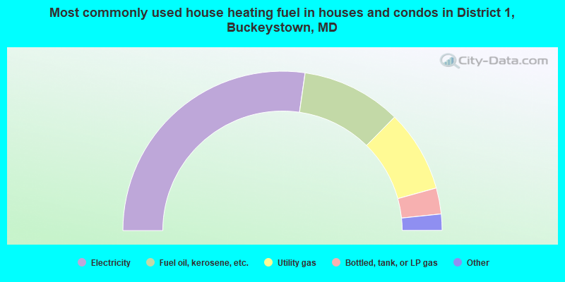
- 54.5%Electricity
- 20.2%Fuel oil, kerosene, etc.
- 16.6%Utility gas
- 5.3%Bottled, tank, or LP gas
- 3.0%Wood
- 0.3%Other fuel
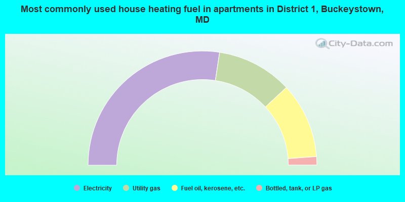
- 54.8%Electricity
- 21.4%Utility gas
- 21.4%Fuel oil, kerosene, etc.
- 2.4%Bottled, tank, or LP gas
District 1, Buckeystown compared to Maryland state average:
- Unemployed percentage significantly below state average.
- Black race population percentage significantly below state average.
- Hispanic race population percentage significantly below state average.
- Foreign-born population percentage significantly below state average.
- Length of stay since moving in significantly above state average.
- Number of rooms per house significantly below state average.
- House age significantly below state average.
District 1, Buckeystown on our top lists:
- #7 on the list of "Top 101 cities with largest percentage of females in occupations: life and physical scientists (population 5,000+)"
- #14 on the list of "Top 101 cities with largest percentage of females in industries: nonmetallic mineral products (population 5,000+)"
- #15 on the list of "Top 101 cities with largest percentage of females in occupations: child care workers (population 5,000+)"
- #17 on the list of "Top 101 cities with largest percentage of males in occupations: food and beverage serving workers except waiters/waitresses (population 5,000+)"
- #25 on the list of "Top 101 cities with largest percentage of males in occupations: vehicle and mobile equipment mechanics, installers, and repairers (population 5,000+)"
- #35 on the list of "Top 101 cities with largest percentage of males in industries: hardware, plumbing and heating equipment, and supplies merchant wholesalers (population 5,000+)"
- #44 on the list of "Top 101 cities with largest percentage of males in occupations: computer specialists (population 5,000+)"
- #46 on the list of "Top 101 cities with largest percentage of females in occupations: entertainers and performers, sports, and related workers (population 5,000+)"
- #55 on the list of "Top 101 cities with largest percentage of females in industries: social assistance (population 5,000+)"
- #87 on the list of "Top 101 cities with largest percentage of females in industries: furniture and home furnishing merchant wholesalers (population 5,000+)"
- #93 on the list of "Top 101 cities with largest percentage of females in industries: private households (population 5,000+)"
- #48 on the list of "Top 101 counties with the best general health status score of residents (1-5), 3 years of data"
- #54 on the list of "Top 101 counties with the highest percentage of residents that visited a dentist within the past year"
- #67 on the list of "Top 101 counties with the largest number of children under 18 without health insurance coverage in 2000 (pop. 50,000+)"
- #80 on the list of "Top 101 counties with the highest percentage of residents that keep firearms around their homes"
- #80 on the list of "Top 101 counties with the largest decrease in the number of births per 1000 residents 2000-2006 to 2007-2013 (pop 50,000+)"