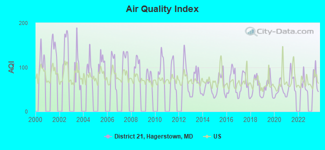
District 21, Hagerstown, Maryland
Submit your own pictures of this city and show them to the world
- OSM Map
- General Map
- Google Map
- MSN Map

| Males: 3,401 | |
| Females: 3,890 |
| Median resident age: | 40.0 years |
| Maryland median age: | 36.0 years |
Zip code: 21742
| District 21, Hagerstown: | $79,185 |
| MD: | $94,991 |
Estimated per capita income in 2022: $43,833 (it was $25,858 in 2000)
District 21, Hagerstown income, earnings, and wages data
Estimated median house or condo value in 2022: $274,855 (it was $110,000 in 2000)
| District 21, Hagerstown: | $274,855 |
| MD: | $398,100 |
Mean prices in 2022: all housing units: $304,947; detached houses: $319,990; townhouses or other attached units: $236,260; in 2-unit structures: $528,214; in 3-to-4-unit structures: $218,469; in 5-or-more-unit structures: $125,300; mobile homes: $118,381
District 21, Hagerstown, MD residents, houses, and apartments details
Detailed information about poverty and poor residents in District 21, Hagerstown, MD


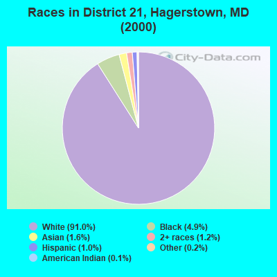
- 6,04891.0%White alone
- 3234.9%Black alone
- 1031.6%Asian alone
- 781.2%Two or more races
- 641.0%Hispanic
- 140.2%Other race alone
- 80.1%American Indian alone
- 50.08%Native Hawaiian and Other
Pacific Islander alone
Races in District 21, Hagerstown detailed stats: ancestries, foreign born residents, place of birth
 Recent articles from our blog. Our writers, many of them Ph.D. graduates or candidates, create easy-to-read articles on a wide variety of topics.
Current Local Time: EST time zone
Land area: 1.74 square miles.
Population density: 4,193 people per square mile (average).

| District 21, Hagerstown: | 1.4% ($1,487) |
| Maryland: | 1.2% ($1,782) |
Nearest city with pop. 50,000+: Frederick, MD  (22.3 miles , pop. 52,767).
Nearest city with pop. 200,000+: Baltimore, MD (63.2 miles , pop. 651,154).
Nearest city with pop. 1,000,000+: Philadelphia, PA (138.3 miles , pop. 1,517,550).
Nearest cities:
), ), ), ), ), ), )Latitude: 39.66 N, Longitude: 77.71 W

| Here: | 2.2% |
| Maryland: | 2.0% |
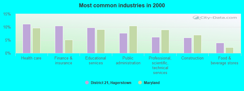
- Health care (11.2%)
- Finance & insurance (10.4%)
- Educational services (9.8%)
- Public administration (7.7%)
- Professional, scientific, technical services (6.1%)
- Construction (5.9%)
- Food & beverage stores (3.9%)
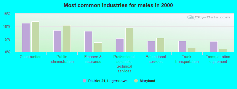
- Construction (11.3%)
- Public administration (8.4%)
- Finance & insurance (8.2%)
- Professional, scientific, technical services (5.4%)
- Educational services (4.4%)
- Truck transportation (4.3%)
- Transportation equipment (4.2%)
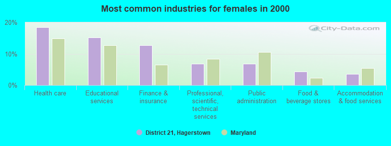
- Health care (18.4%)
- Educational services (15.2%)
- Finance & insurance (12.7%)
- Professional, scientific, technical services (6.9%)
- Public administration (6.9%)
- Food & beverage stores (4.3%)
- Accommodation & food services (3.6%)
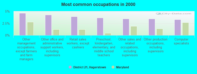
- Other management occupations, except farmers and farm managers (4.6%)
- Other office and administrative support workers, including supervisors (4.3%)
- Retail sales workers, except cashiers (3.9%)
- Preschool, kindergarten, elementary, and middle school teachers (3.7%)
- Other sales and related occupations, including supervisors (3.4%)
- Other production occupations, including supervisors (3.4%)
- Computer specialists (3.3%)
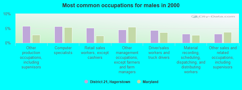
- Other production occupations, including supervisors (5.8%)
- Computer specialists (5.6%)
- Retail sales workers, except cashiers (5.2%)
- Other management occupations, except farmers and farm managers (4.6%)
- Driver/sales workers and truck drivers (4.4%)
- Material recording, scheduling, dispatching, and distributing workers (3.1%)
- Other sales and related occupations, including supervisors (3.1%)
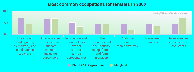
- Preschool, kindergarten, elementary, and middle school teachers (7.0%)
- Other office and administrative support workers, including supervisors (6.7%)
- Information and record clerks, except customer service representatives (5.2%)
- Other management occupations, except farmers and farm managers (4.7%)
- Customer service representatives (4.7%)
- Registered nurses (4.6%)
- Secretaries and administrative assistants (4.5%)
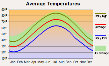
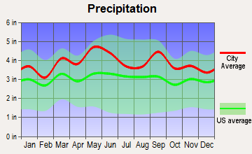
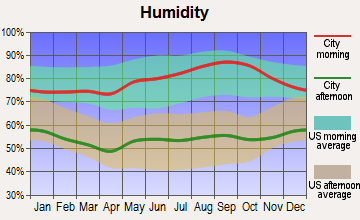
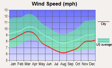
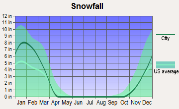
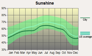
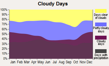
Average climate in District 21, Hagerstown, Maryland
Based on data reported by over 4,000 weather stations

Tornado activity:
District 21, Hagerstown-area historical tornado activity is near Maryland state average. It is 8% smaller than the overall U.S. average.
On 5/22/1983, a category F3 (max. wind speeds 158-206 mph) tornado 24.7 miles away from the District 21, Hagerstown city center caused between $5000 and $50,000 in damages.
On 4/16/1961, a category F3 tornado 28.9 miles away from the city center caused between $50,000 and $500,000 in damages.
Earthquake activity:
District 21, Hagerstown-area historical earthquake activity is significantly above Maryland state average. It is 55% smaller than the overall U.S. average.On 8/23/2011 at 17:51:04, a magnitude 5.8 (5.8 MW, Depth: 3.7 mi, Class: Moderate, Intensity: VI - VII) earthquake occurred 121.6 miles away from the city center
On 9/25/1998 at 19:52:52, a magnitude 5.2 (4.8 MB, 4.3 MS, 5.2 LG, 4.5 MW, Depth: 3.1 mi) earthquake occurred 189.6 miles away from the city center
On 1/16/1994 at 01:49:16, a magnitude 4.6 (4.6 MB, 4.6 LG, Depth: 3.1 mi, Class: Light, Intensity: IV - V) earthquake occurred 100.1 miles away from the city center
On 8/25/2011 at 05:07:52, a magnitude 4.5 (4.5 ML, Depth: 4.2 mi) earthquake occurred 119.2 miles away from District 21, Hagerstown center
On 1/31/1986 at 16:46:43, a magnitude 5.0 (5.0 MB) earthquake occurred 225.5 miles away from District 21, Hagerstown center
On 12/9/2003 at 20:59:18, a magnitude 4.5 (4.5 ML, Depth: 6.2 mi) earthquake occurred 132.0 miles away from District 21, Hagerstown center
Magnitude types: regional Lg-wave magnitude (LG), body-wave magnitude (MB), local magnitude (ML), surface-wave magnitude (MS), moment magnitude (MW)
Natural disasters:
The number of natural disasters in Washington County (15) is near the US average (15).Major Disasters (Presidential) Declared: 9
Emergencies Declared: 5
Causes of natural disasters: Hurricanes: 5, Floods: 3, Snowstorms: 3, Winter Storms: 3, Blizzard: 1, Heavy Rain: 1, Snowfall: 1, Storm: 1, Tropical Storm: 1, Other: 1 (Note: some incidents may be assigned to more than one category).
Hospitals and medical centers near District 21, Hagerstown:
- COFFMAN NURSING HOME (Nursing Home, about 1 miles away; HAGERSTOWN, MD)
- HOSPICE OF WASHINGTON CNTY INC (Hospital, about 1 miles away; HAGERSTOWN, MD)
- WESTERN MARYLAND CENTER (Hospital, about 1 miles away; HAGERSTOWN, MD)
- WESTERN MD HOSPITAL CENTER (Nursing Home, about 1 miles away; HAGERSTOWN, MD)
- FMC - HAGERSTOWN (Dialysis Facility, about 1 miles away; HAGERSTOWN, MD)
- POTOMAC CENTER (Hospital, about 2 miles away; HAGERSTOWN, MD)
- WASHINGTON COUNTY HOSP. ECF (Nursing Home, about 2 miles away; HAGERSTOWN, MD)
Amtrak stations near District 21, Hagerstown:
- 7 miles: HAGERSTOWN (GREYHOUND STA., 10527 SHARPSTOWN PK.) - Bus Station . Services: enclosed waiting area, public restrooms, public payphones, snack bar.
- 20 miles: MARTINSBURG (229 E. MARTIN ST.) . Services: fully wheelchair accessible, enclosed waiting area, public restrooms, public payphones, paid short-term parking, taxi stand, public transit connection.
Colleges/universities with over 2000 students nearest to District 21, Hagerstown:
- Hagerstown Community College (about 3 miles; Hagerstown, MD; Full-time enrollment: 3,220)
- Shepherd University (about 17 miles; Shepherdstown, WV; FT enrollment: 3,745)
- Mount St Mary's University (about 20 miles; Emmitsburg, MD; FT enrollment: 2,313)
- Frederick Community College (about 22 miles; Frederick, MD; FT enrollment: 3,798)
- American Public University System (about 27 miles; Charles Town, WV; FT enrollment: 43,829)
- Gettysburg College (about 29 miles; Gettysburg, PA; FT enrollment: 2,772)
- Shippensburg University of Pennsylvania (about 30 miles; Shippensburg, PA; FT enrollment: 7,051)
Points of interest:
Shopping Center: Long Meadow Shopping Center (1). Display/hide its location on the map
Church in District 21, Hagerstown: First Christian Church (A). Display/hide its location on the map
Park in District 21, Hagerstown: Oak Hill Historic District (1). Display/hide its location on the map
| This city: | 2.3 people |
| Maryland: | 2.6 people |
| This city: | 59.8% |
| Whole state: | 67.1% |
| This city: | 9.3% |
| Whole state: | 6.4% |
Likely homosexual households (counted as self-reported same-sex unmarried-partner households)
- Lesbian couples: 0.6% of all households
- Gay men: 0.6% of all households
| This city: | 6.3% |
| Whole state: | 8.5% |
| This city: | 2.7% |
| Whole state: | 4.2% |
People in group quarters in District 21, Hagerstown in 2010:
- 109 people in nursing facilities/skilled-nursing facilities
- 15 people in residential treatment centers for juveniles (non-correctional)
- 9 people in group homes intended for adults
People in group quarters in District 21, Hagerstown in 2000:
- 57 people in nursing homes
- 22 people in other nonhousehold living situations
- 3 people in religious group quarters
For population 15 years and over in District 21, Hagerstown:
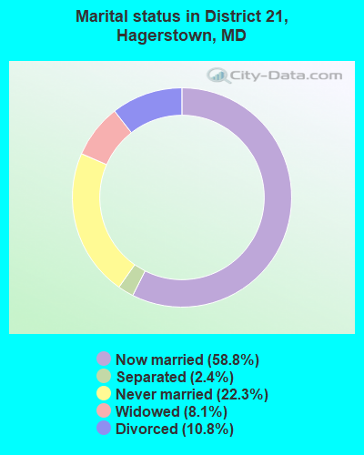
- Never married: 22.3%
- Now married: 58.8%
- Separated: 2.4%
- Widowed: 8.1%
- Divorced: 10.8%
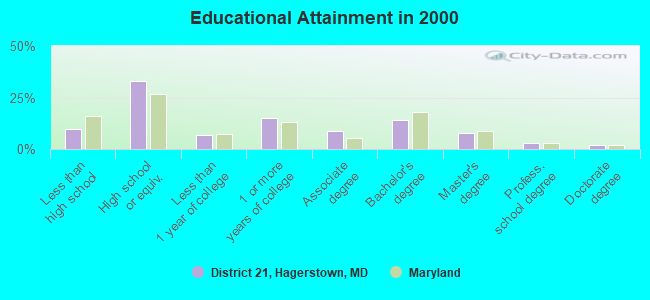
For population 25 years and over in District 21, Hagerstown:
- High school or higher: 90.1%
- Bachelor's degree or higher: 27.0%
- Graduate or professional degree: 12.7%
- Unemployed: 1.9%
- Mean travel time to work (commute): 20.1 minutes
| Here: | 11.1 |
| Maryland average: | 12.7 |
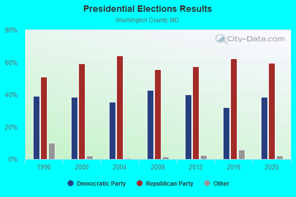
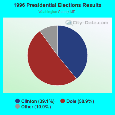
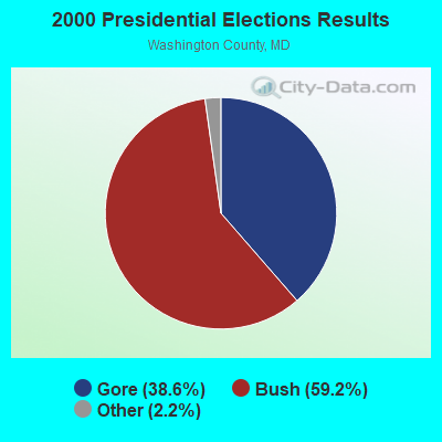
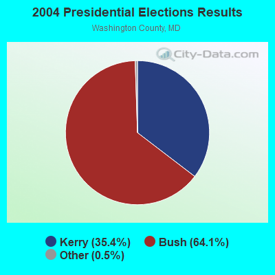
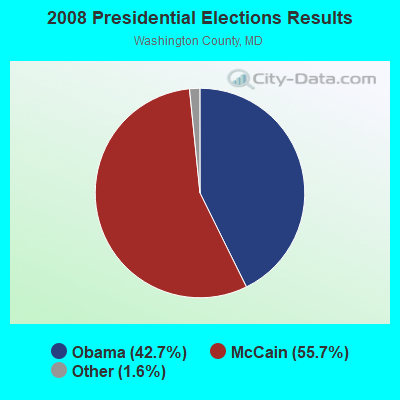
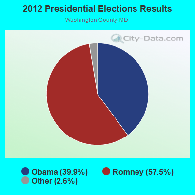
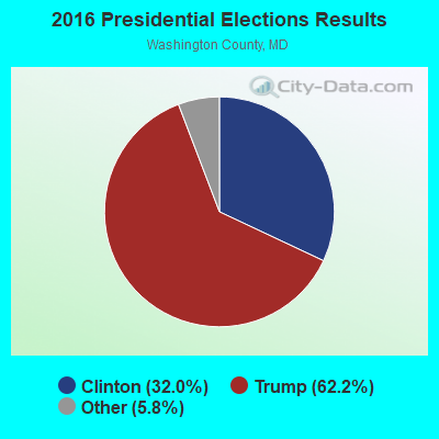
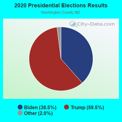
Graphs represent county-level data. Detailed 2008 Election Results
Religion statistics for District 21, Hagerstown, MD (based on Washington County data)
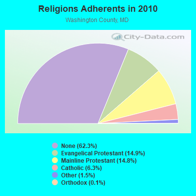
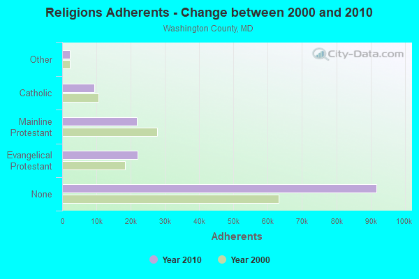
| Religion | Adherents | Congregations |
|---|---|---|
| Evangelical Protestant | 21,941 | 117 |
| Mainline Protestant | 21,837 | 79 |
| Catholic | 9,350 | 8 |
| Other | 2,244 | 11 |
| Orthodox | 163 | 2 |
| Black Protestant | 97 | 2 |
| None | 91,798 | - |
Food Environment Statistics:
| Washington County: | 1.73 / 10,000 pop. |
| Maryland: | 1.96 / 10,000 pop. |
| Washington County: | 0.14 / 10,000 pop. |
| State: | 0.07 / 10,000 pop. |
| This county: | 1.04 / 10,000 pop. |
| Maryland: | 1.22 / 10,000 pop. |
| This county: | 2.83 / 10,000 pop. |
| Maryland: | 2.05 / 10,000 pop. |
| Washington County: | 6.43 / 10,000 pop. |
| Maryland: | 5.40 / 10,000 pop. |
| Washington County: | 10.2% |
| Maryland: | 9.1% |
| Here: | 28.8% |
| Maryland: | 26.7% |
| Washington County: | 12.9% |
| Maryland: | 15.5% |
Strongest AM radio stations in District 21, Hagerstown:
- WJEJ (1240 AM; 1 kW; HAGERSTOWN, MD; Owner: HAGERSTOWN BROADCASTING COMPANY)
- WARK (1490 AM; 1 kW; HAGERSTOWN, MD; Owner: MANNING BROADCASTING, INC.)
- WHAG (1410 AM; 1 kW; HALFWAY, MD; Owner: DAME BROADCASTING, LLC)
- WCBM (680 AM; 50 kW; BALTIMORE, MD; Owner: WCBM MARYLAND, INC.)
- WMET (1150 AM; 50 kW; GAITHERSBURG, MD; Owner: BELTWAY ACQUISITION CORPORATION)
- WTRI (1520 AM; daytime; 17 kW; BRUNSWICK, MD; Owner: JMK COMMUNICATIONS, INC.)
- WBAL (1090 AM; 50 kW; BALTIMORE, MD; Owner: HEARST RADIO, INC.)
- WGOP (700 AM; daytime; 25 kW; WALKERSVILLE, MD; Owner: BIRACH BROADCASTING CORPORATION)
- WTEM (980 AM; 50 kW; WASHINGTON, DC; Owner: AMFM RADIO LICENSES, L.L.C.)
- WFMD (930 AM; 5 kW; FREDERICK, MD; Owner: CAPSTAR TX LIMITED PARTNERSHIP)
- WHGT (1380 AM; 1 kW; WAYNESBORO, PA)
- WXTR (820 AM; 4 kW; FREDERICK, MD; Owner: BONNEVILLE HOLDING COMPANY)
- WTOP (1500 AM; 50 kW; WASHINGTON, DC; Owner: BONNEVILLE HOLDING COMPANY)
Strongest FM radio stations in District 21, Hagerstown:
- WAYZ-FM (104.7 FM; HAGERSTOWN, MD; Owner: HJV LIMITED PARTNERSHIP)
- WETH (89.1 FM; HAGERSTOWN, MD; Owner: GREATER WASHINGTON EDUCATIONAL TELECOMMUNICATIONS ASSN.)
- WDLD (96.7 FM; HALFWAY, MD; Owner: DAME BROADCASTING, LLC)
- WKMZ (95.9 FM; WILLIAMSPORT, MD; Owner: PRETTYMAN BROADCASTING COMPANY)
- WFRE (99.9 FM; FREDERICK, MD; Owner: CAPSTAR TX LIMITED PARTNERSHIP)
- WARX (106.9 FM; HAGERSTOWN, MD; Owner: MANNING BROADCASTING INC.)
- W228AB (93.5 FM; PARAMOUNT, ETC., MD; Owner: FAMILY STATIONS, INC.)
- W219BX (91.7 FM; FREDERICK, MD; Owner: CEDAR RIDGE CHILDREN'S HOME & SCHOOL, INC)
- WCRH (90.5 FM; WILLIAMSPORT, MD; Owner: CEDAR RIDGE CHILDREN'S HOME & SCHOOL, INC)
- W219BE (91.7 FM; WAYNESBORO, PA; Owner: MARANATHA BIBLE INSTITUTE, NDBA)
- WEEO-FM (103.7 FM; MCCONNELLSBURG, PA; Owner: ALLEGHENY MOUNTAIN NETWORK)
- WQCM (94.3 FM; GREENCASTLE, PA; Owner: DAME BROADCASTING, LLC)
- WWVZ (103.9 FM; BRADDOCK HEIGHTS, MD; Owner: BONNEVILLE HOLDING COMPANY)
- WSRT (92.1 FM; MERCERSBURG, PA; Owner: M. BELMONT VERSTANDIG, INC.)
- WLTF (97.5 FM; MARTINSBURG, WV; Owner: PRETTYMAN BROADCASTING COMPANY)
- WAFY (103.1 FM; MIDDLETOWN, MD; Owner: FREDERICK BROADCASTING LLC)
- WIKZ (95.1 FM; CHAMBERSBURG, PA; Owner: DAME BROADCASTING, LLC)
- W228BA (93.5 FM; LEESBURG, VA; Owner: CSN INTERNATIONAL)
- WTRM (91.3 FM; WINCHESTER, VA; Owner: TIMBER RIDGE MINISTRIES, INC.)
- WINC-FM (92.5 FM; WINCHESTER, VA; Owner: MID ATLANTIC NETWORK, INC.)
TV broadcast stations around District 21, Hagerstown:
- W42CK (Channel 42; HAGERSTOWN, MD; Owner: THREE ANGELS BROADCASTING)
- WHAG-TV (Channel 25; HAGERSTOWN, MD; Owner: QUORUM OF MARYLAND LICENSE, LLC)
- WWPB (Channel 31; HAGERSTOWN, MD; Owner: MARYLAND PUBLIC BROADCASTING COMMISSION)
- WJAL (Channel 68; HAGERSTOWN, MD; Owner: ENTRAVISION HOLDINGS, LLC)
- W51CY (Channel 51; CHAMBERSBURG, PA; Owner: WBDC BROADCASTING, INC.)
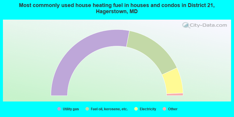
- 56.0%Utility gas
- 30.1%Fuel oil, kerosene, etc.
- 12.6%Electricity
- 0.7%Bottled, tank, or LP gas
- 0.3%Other fuel
- 0.3%Wood
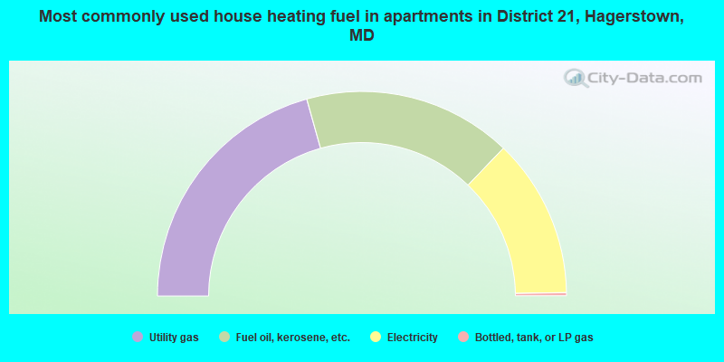
- 41.3%Utility gas
- 33.0%Fuel oil, kerosene, etc.
- 25.2%Electricity
- 0.5%Bottled, tank, or LP gas
District 21, Hagerstown compared to Maryland state average:
- Unemployed percentage significantly below state average.
- Black race population percentage significantly below state average.
- Hispanic race population percentage significantly below state average.
- Median age above state average.
- Foreign-born population percentage significantly below state average.
- Length of stay since moving in significantly above state average.
- Number of rooms per house significantly below state average.
- House age significantly below state average.
- Number of college students below state average.
District 21, Hagerstown on our top lists:
- #17 on the list of "Top 101 cities with largest percentage of females in industries: data processing, libraries, and other information services (population 5,000+)"
- #22 on the list of "Top 101 cities with largest percentage of males in occupations: bookkeeping, accounting, and auditing clerks (population 5,000+)"
- #28 on the list of "Top 101 cities with largest percentage of males in occupations: retail sales workers except cashiers (population 5,000+)"
- #31 on the list of "Top 101 cities with largest percentage of males in industries: furniture and home furnishings, and household appliance stores (population 5,000+)"
- #31 on the list of "Top 101 cities with largest percentage of males in industries: leather and allied products (population 5,000+)"
- #34 on the list of "Top 101 cities with largest percentage of females in occupations: financial managers (population 5,000+)"
- #37 on the list of "Top 101 cities with largest percentage of females in industries: motor vehicle and parts dealers (population 5,000+)"
- #39 on the list of "Top 101 cities with largest percentage of females in occupations: customer service representatives (population 5,000+)"
- #42 on the list of "Top 101 cities with largest percentage of males in industries: professional and commercial equipment and supplies merchant wholesalers (population 5,000+)"
- #44 on the list of "Top 101 cities with largest percentage of females in industries: rail transportation (population 5,000+)"
- #45 on the list of "Top 101 cities with largest percentage of males in industries: radio, tv, and computer stores (population 5,000+)"
- #50 on the list of "Top 101 cities with largest percentage of males in industries: hardware, plumbing and heating equipment, and supplies merchant wholesalers (population 5,000+)"
- #53 on the list of "Top 101 cities with largest percentage of males in industries: farm product raw materials merchant wholesalers (population 5,000+)"
- #56 on the list of "Top 101 cities with largest percentage of females in industries: lumber and other construction materials merchant wholesalers (population 5,000+)"
- #63 on the list of "Top 101 cities with largest percentage of females in industries: drugs, sundries, and chemical and allied products merchant wholesalers (population 5,000+)"
- #68 on the list of "Top 101 cities with largest percentage of males in occupations: counselors, social workers, and other community and social service specialists (population 5,000+)"
- #73 on the list of "Top 101 cities with largest percentage of females in occupations: art and design workers (population 5,000+)"
- #67 on the list of "Top 101 counties with the lowest percentage of residents relocating to foreign countries in 2011"
- #77 on the list of "Top 101 counties with the lowest percentage of residents that exercised in the past month"