District 7, Milestown, Maryland
Submit your own pictures of this city and show them to the world
- OSM Map
- General Map
- Google Map
- MSN Map

| Males: 1,811 | |
| Females: 1,828 |
| Median resident age: | 41.6 years |
| Maryland median age: | 36.0 years |
Zip code: 20618
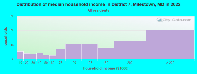
| District 7, Milestown: | $115,675 |
| MD: | $94,991 |
Estimated per capita income in 2022: $61,677 (it was $25,722 in 2000)
District 7, Milestown income, earnings, and wages data
Estimated median house or condo value in 2022: $385,649 (it was $144,900 in 2000)
| District 7, Milestown: | $385,649 |
| MD: | $398,100 |
Mean prices in 2022: all housing units: $420,835; detached houses: $434,448; townhouses or other attached units: $291,891; in 2-unit structures: $256,566; in 3-to-4-unit structures: $251,015; in 5-or-more-unit structures: $338,851; mobile homes: $282,703
District 7, Milestown, MD residents, houses, and apartments details
Detailed information about poverty and poor residents in District 7, Milestown, MD
Compare current foreclosures near your location:
| Photo | Address | Area | Beds / Baths | Price | Details |
|---|---|---|---|---|---|

|
#1
Bayberry Cir
Columbus, OH 43207
|
1,564 sq. feet
|
1 baths 3 beds |
$127,500
|
show details |

|
#2
E 21st Ave
Columbus, OH 43211
|
1,061 sq. feet
|
1 baths 3 beds |
$187,900
|
show details |

|
#3
S High St
Columbus, OH 43207
|
1,678 sq. feet
|
2 baths 4 beds |
$31,900
|
show details |

|
#4
Midland Ave
Columbus, OH 43223
|
1,518 sq. feet
|
1 baths 2 beds |
show details | |

|
#5
Mink St SW
Pataskala, OH 43062
|
1,442 sq. feet
|
1 baths 3 beds |
show details | |

|
#6
Falls Peak Ln
Delaware, OH 43015
|
1,352 sq. feet
|
2 baths 2 beds |
show details | |

|
#7
Kingsglen Dr
Grove City, OH 43123
|
1,635 sq. feet
|
2 baths 4 beds |
show details | |

|
#8
Wrexham Ave
Columbus, OH 43223
|
1,235 sq. feet
|
1 baths 3 beds |
show details | |

|
#9
Hiawatha Park Dr
Columbus, OH 43211
|
1,278 sq. feet
|
1 baths 4 beds |
show details | |

|
#10
Arborlee Dr
Reynoldsburg, OH 43068
|
1,263 sq. feet
|
2 baths 3 beds |
show details |
| Photo | Address | Area | Beds / Baths | Price | Details |
|---|---|---|---|---|---|

|
#11
High Free Pike
West Jefferson, OH 43162
|
1,216 sq. feet
|
2 baths 4 beds |
show details | |

|
#12
Ferris Rd
Columbus, OH 43224
|
2,218 sq. feet
|
3 baths 3 beds |
show details | |

|
#13
Marshrun Dr
Grove City, OH 43123
|
2,036 sq. feet
|
2 baths 4 beds |
show details | |

|
#14
S Richardson Ave
Columbus, OH 43204
|
1,520 sq. feet
|
2 baths 3 beds |
show details | |

|
#15
Meadowbrook Dr
Columbus, OH 43207
|
1,752 sq. feet
|
2 baths 4 beds |
show details | |

|
#16
Fergus Rd
Grove City, OH 43123
|
3,312 sq. feet
|
2 baths 4 beds |
show details | |

|
#17
S Chillicothe St
Plain City, OH 43064
|
1,736 sq. feet
|
2 baths 4 beds |
show details | |

|
#18
Fahlander Dr N
Columbus, OH 43229
|
1,338 sq. feet
|
2 baths 3 beds |
show details | |

|
#19
E Welch Ave
Columbus, OH 43207
|
1,864 sq. feet
|
2 baths 3 beds |
show details | |

|
#20
S Hague Ave
Columbus, OH 43204
|
979 sq. feet
|
1 baths 2 beds |
show details |
| Photo | Address | Area | Beds / Baths | Price | Details |
|---|---|---|---|---|---|

|
#21
N Grener Ave
Columbus, OH 43228
|
1,120 sq. feet
|
1 baths 3 beds |
show details | |

|
#22
Vineyard Haven Loop
Dublin, OH 43016
|
4,625 sq. feet
|
4 baths 4 beds |
show details | |

|
#23
Brookstone Dr
Westerville, OH 43082
|
1,783 sq. feet
|
3 baths 3 beds |
show details | |

|
#24
N Roys Ave
Columbus, OH 43204
|
1,248 sq. feet
|
2 baths 3 beds |
show details | |

|
#25
Bretton Pl
Columbus, OH 43211
|
1,056 sq. feet
|
1 baths 3 beds |
show details | |

|
#26
Scottwood Rd
Columbus, OH 43227
|
1,008 sq. feet
|
1 baths 3 beds |
show details | |

|
#27
Rosewood Ct
Powell, OH 43065
|
2,801 sq. feet
|
3 baths 4 beds |
show details | |

|
#28
Sleeping Meadow Dr
New Albany, OH 43054
|
3,211 sq. feet
|
2 baths 4 beds |
show details | |

|
#29
Bernadette Rd
Columbus, OH 43204
|
1,168 sq. feet
|
1 baths 3 beds |
show details | |

|
#30
Elaine Rd
Columbus, OH 43213
|
764 sq. feet
|
1 baths 2 beds |
show details |
| Photo | Address | Area | Beds / Baths | Price | Details |
|---|---|---|---|---|---|

|
#31
Belle Oak Dr
Galloway, OH 43119
|
1,296 sq. feet
|
2 baths 3 beds |
show details | |

|
#32
Stoneybrook Blvd # 21a
Hilliard, OH 43026
|
1,231 sq. feet
|
2 baths 3 beds |
show details | |

|
#33
Spohn Dr
Westerville, OH 43081
|
1,040 sq. feet
|
1 baths 3 beds |
show details | |

|
#34
Mayflower Blvd
Columbus, OH 43213
|
1,591 sq. feet
|
2 baths 4 beds |
show details | |

|
#35
Derrer Rd -872
Columbus, OH 43204
|
1,667 sq. feet
|
2 baths 5 beds |
show details | |

|
#36
Beacontree Dr
Columbus, OH 43224
|
1,412 sq. feet
|
2 baths 3 beds |
show details | |

|
#37
Brookgrove Dr
Grove City, OH 43123
|
942 sq. feet
|
1 baths 3 beds |
show details | |

|
#38
Danforth Rd
Columbus, OH 43224
|
1,080 sq. feet
|
1 baths 3 beds |
show details | |

|
#39
Silverglade Dr
Columbus, OH 43230
|
1,741 sq. feet
|
2 baths 3 beds |
show details | |

|
#40
Fenton St
Columbus, OH 43224
|
960 sq. feet
|
1 baths 3 beds |
show details |
| Photo | Address | Area | Beds / Baths | Price | Details |
|---|---|---|---|---|---|

|
#41
Pershing Dr
Columbus, OH 43224
|
1,440 sq. feet
|
1 baths 3 beds |
show details | |

|
#42
Nautical Dr
Columbus, OH 43207
|
1,320 sq. feet
|
2 baths 3 beds |
show details | |

|
#43
Rutgers Ln
Hilliard, OH 43026
|
832 sq. feet
|
1 baths 2 beds |
show details | |

|
#44
Haughn Rd
Grove City, OH 43123
|
1,931 sq. feet
|
1 baths 3 beds |
show details | |

|
#45
Chantilly St
Columbus, OH 43207
|
939 sq. feet
|
1 baths 3 beds |
show details | |

|
#46
Batavia Ct
Westerville, OH 43081
|
1,433 sq. feet
|
1 baths 3 beds |
show details | |

|
#47
Legionary St
Columbus, OH 43207
|
1,200 sq. feet
|
1 baths 3 beds |
show details | |

|
#48
Voeller Cir
Grove City, OH 43123
|
1,128 sq. feet
|
1 baths 3 beds |
show details | |

|
#49
Balford Sq W
Columbus, OH 43232
|
1,444 sq. feet
|
1 baths 3 beds |
show details | |

|
Check over 1 million property listings on Foreclosure.com!
|
browse all offers | |||

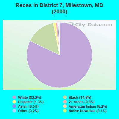
- 2,57882.2%White alone
- 46314.8%Black alone
- 401.3%Hispanic
- 240.8%Two or more races
- 150.5%Asian alone
- 70.2%American Indian alone
- 50.2%Other race alone
- 40.1%Native Hawaiian and Other
Pacific Islander alone
Races in District 7, Milestown detailed stats: ancestries, foreign born residents, place of birth
 Recent articles from our blog. Our writers, many of them Ph.D. graduates or candidates, create easy-to-read articles on a wide variety of topics.
Current Local Time: EST time zone
Land area: 26.2 square miles.
Population density: 139 people per square mile (very low).

| District 7, Milestown: | 0.8% ($1,195) |
| Maryland: | 1.2% ($1,782) |
Nearest city with pop. 50,000+: Dale City, VA  (40.1 miles , pop. 55,971).
Nearest city with pop. 200,000+: Washington, DC (46.2 miles , pop. 572,059).
Nearest city with pop. 1,000,000+: Philadelphia, PA (148.2 miles , pop. 1,517,550).
Nearest cities:
), ), ), ), )Latitude: 38.27 N, Longitude: 76.78 W

| Here: | 1.9% |
| Maryland: | 2.0% |

- Construction (14.6%)
- Public administration (12.3%)
- Utilities (7.2%)
- Health care (6.3%)
- Professional, scientific, technical services (5.7%)
- Educational services (5.3%)
- Agriculture, forestry, fishing & hunting (4.5%)
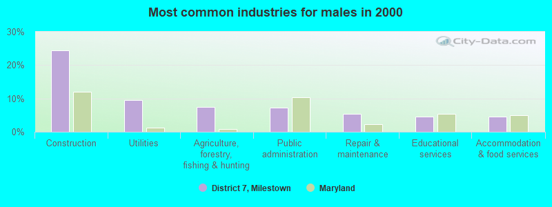
- Construction (24.4%)
- Utilities (9.5%)
- Agriculture, forestry, fishing & hunting (7.4%)
- Public administration (7.3%)
- Repair & maintenance (5.5%)
- Educational services (4.5%)
- Accommodation & food services (4.5%)
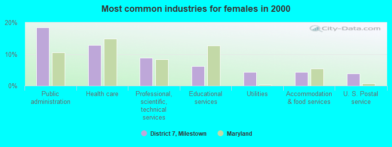
- Public administration (18.4%)
- Health care (12.8%)
- Professional, scientific, technical services (8.8%)
- Educational services (6.2%)
- Utilities (4.3%)
- Accommodation & food services (4.3%)
- U. S. Postal service (3.9%)
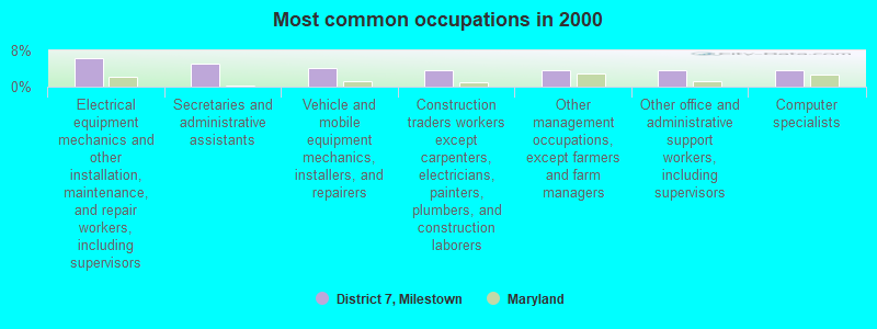
- Electrical equipment mechanics and other installation, maintenance, and repair workers, including supervisors (6.3%)
- Secretaries and administrative assistants (5.1%)
- Vehicle and mobile equipment mechanics, installers, and repairers (4.2%)
- Construction traders workers except carpenters, electricians, painters, plumbers, and construction laborers (3.7%)
- Other management occupations, except farmers and farm managers (3.6%)
- Other office and administrative support workers, including supervisors (3.6%)
- Computer specialists (3.6%)
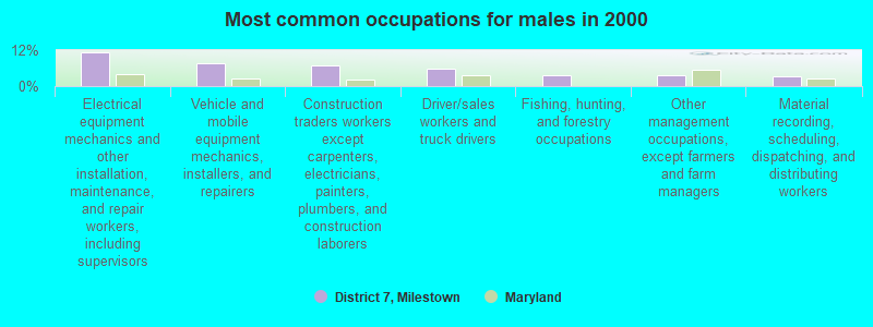
- Electrical equipment mechanics and other installation, maintenance, and repair workers, including supervisors (11.4%)
- Vehicle and mobile equipment mechanics, installers, and repairers (7.6%)
- Construction traders workers except carpenters, electricians, painters, plumbers, and construction laborers (6.8%)
- Driver/sales workers and truck drivers (5.7%)
- Fishing, hunting, and forestry occupations (3.8%)
- Other management occupations, except farmers and farm managers (3.7%)
- Material recording, scheduling, dispatching, and distributing workers (3.5%)
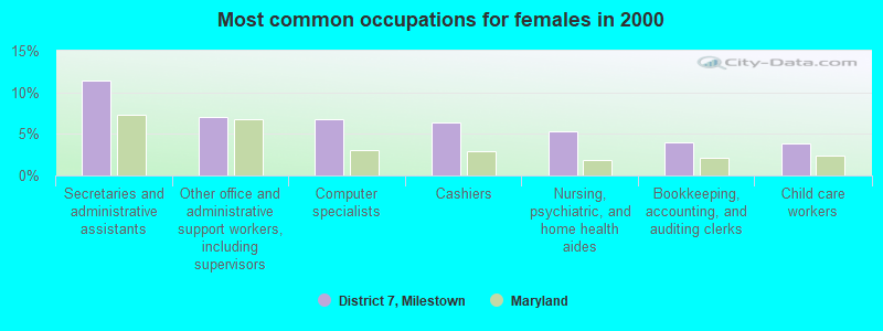
- Secretaries and administrative assistants (11.4%)
- Other office and administrative support workers, including supervisors (7.1%)
- Computer specialists (6.8%)
- Cashiers (6.3%)
- Nursing, psychiatric, and home health aides (5.3%)
- Bookkeeping, accounting, and auditing clerks (4.0%)
- Child care workers (3.9%)
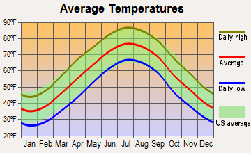
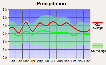
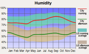
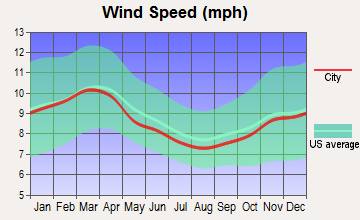
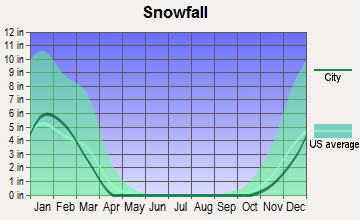
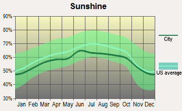
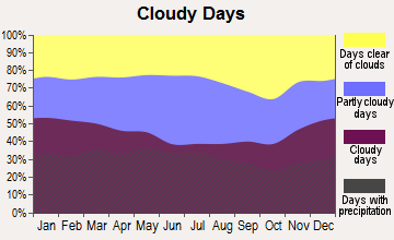
Average climate in District 7, Milestown, Maryland
Based on data reported by over 4,000 weather stations
Tornado activity:
District 7, Milestown-area historical tornado activity is near Maryland state average. It is 9% smaller than the overall U.S. average.
On 4/28/2002, a category F4 (max. wind speeds 207-260 mph) tornado 20.9 miles away from the District 7, Milestown city center killed 3 people and injured 122 people and caused $124 million in damages.
On 11/2/1966, a category F3 (max. wind speeds 158-206 mph) tornado 20.9 miles away from the city center injured 2 people and caused between $5000 and $50,000 in damages.
Earthquake activity:
District 7, Milestown-area historical earthquake activity is significantly above Maryland state average. It is 58% smaller than the overall U.S. average.On 8/23/2011 at 17:51:04, a magnitude 5.8 (5.8 MW, Depth: 3.7 mi, Class: Moderate, Intensity: VI - VII) earthquake occurred 67.8 miles away from the city center
On 8/25/2011 at 05:07:52, a magnitude 4.5 (4.5 ML, Depth: 4.2 mi, Class: Light, Intensity: IV - V) earthquake occurred 68.4 miles away from District 7, Milestown center
On 12/9/2003 at 20:59:14, a magnitude 4.5 (4.5 MB, 4.5 LG) earthquake occurred 77.4 miles away from District 7, Milestown center
On 12/9/2003 at 20:59:18, a magnitude 4.5 (4.5 ML, Depth: 6.2 mi) earthquake occurred 79.7 miles away from District 7, Milestown center
On 1/16/1994 at 01:49:16, a magnitude 4.6 (4.6 MB, 4.6 LG, Depth: 3.1 mi) earthquake occurred 147.9 miles away from the city center
On 8/24/2011 at 00:04:36, a magnitude 4.2 (4.2 ML) earthquake occurred 68.5 miles away from District 7, Milestown center
Magnitude types: regional Lg-wave magnitude (LG), body-wave magnitude (MB), local magnitude (ML), moment magnitude (MW)
Hospitals and medical centers near District 7, Milestown:
- MEDSTAR SAINT MARY'S HOSPITAL Acute Care Hospitals (about 8 miles away; LEONARDTOWN, MD)
- ST. MARY'S NURSING CENTER INC (Nursing Home, about 8 miles away; LEONARDTOWN, MD)
- WESTMORELAND REHABILITATION AND HEALTHCARE CENTER (Nursing Home, about 12 miles away; COLONIAL BEACH, VA)
- CHARLOTTE HALL VETERANS HOME (Nursing Home, about 15 miles away; CHARLOTTE HALL, MD)
Operable nuclear power plants near District 7, Milestown:
- 20 miles: Calvert Cliffs 1 and 2 in Lusby, MD.
Colleges/universities with over 2000 students nearest to District 7, Milestown:
- College of Southern Maryland (about 24 miles; La Plata, MD; Full-time enrollment: 5,775)
- University of Mary Washington (about 38 miles; Fredericksburg, VA; FT enrollment: 4,506)
- Strayer University-Maryland (about 40 miles; Suitland, MD; FT enrollment: 2,748)
- Prince George's Community College (about 43 miles; Largo, MD; FT enrollment: 8,537)
- George Washington University (about 46 miles; Washington, DC; FT enrollment: 18,928)
- Strayer University-Virginia (about 46 miles; Arlington, VA; FT enrollment: 7,005)
- Strayer University-Global Region (about 46 miles; Washington, DC; FT enrollment: 2,613)
Points of interest:
Notable locations in District 7, Milestown: Little Hackley (A), Enfield (B), The Glebe (C), River View (D), Penerine (E), Old Wharf Landing (F), Ocean Hall (G), Neals Lott (H), Mattapany Plantation (I), Maiden Bower (J), Hatchs Thicket (K), Fosters Neck (L), Fog Hall (M), Cobrums Wharf (N), Burlington (O), Bloomfield (P), Blairs Purchase (Q), Bayside Wharf (R), Barton Hall (S), Friendly Hall (T). Display/hide their locations on the map
Churches in District 7, Milestown include: All Saints Church (A), Holy Angels Church (B), Sacred Heart Church (C), Sacred Heart Catholic Church (D). Display/hide their locations on the map
Cemetery: All Saints Cemetery (1). Display/hide its location on the map
Swamps: Church Swamp (A). Display/hide its location on the map
Streams, rivers, and creeks: Dynard Run (A), Whites Neck Creek (B), Tomakokin Creek (C), Canoe Neck Creek (D), Cedar Point Creek (E). Display/hide their locations on the map
Parks in District 7, Milestown include: Saint Clements Island Historic District (1), Seventh District Community Park (2). Display/hide their locations on the map
Beach: Port Sunlight Beach (A). Display/hide its location on the map
| This city: | 2.4 people |
| Maryland: | 2.6 people |
| This city: | 69.3% |
| Whole state: | 67.1% |
| This city: | 8.5% |
| Whole state: | 6.4% |
Likely homosexual households (counted as self-reported same-sex unmarried-partner households)
- Lesbian couples: 0.4% of all households
- Gay men: 0.1% of all households
| This city: | 7.9% |
| Whole state: | 8.5% |
| This city: | 2.2% |
| Whole state: | 4.2% |
2 people in other group homes in 2000
For population 15 years and over in District 7, Milestown:
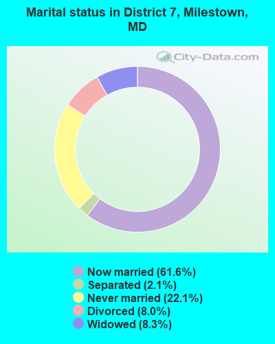
- Never married: 22.1%
- Now married: 61.6%
- Separated: 2.1%
- Widowed: 8.3%
- Divorced: 8.0%
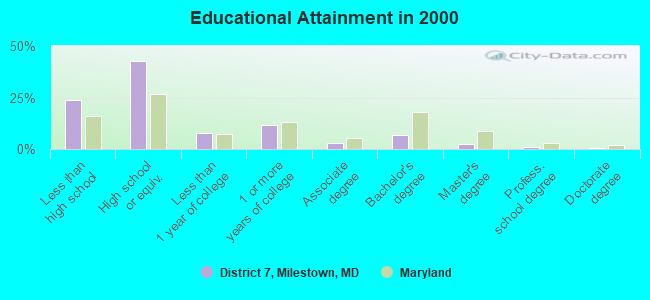
For population 25 years and over in District 7, Milestown:
- High school or higher: 76.0%
- Bachelor's degree or higher: 10.8%
- Graduate or professional degree: 4.1%
- Unemployed: 1.8%
- Mean travel time to work (commute): 40.3 minutes
| Here: | 10.9 |
| Maryland average: | 12.7 |
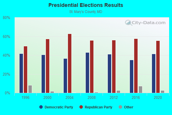
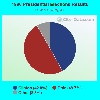

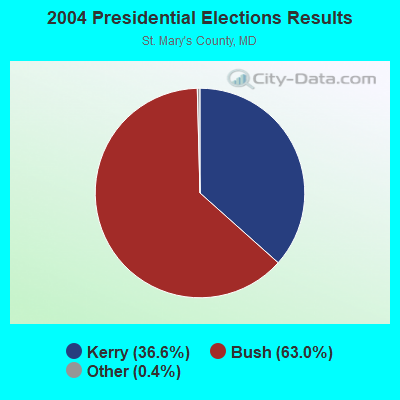
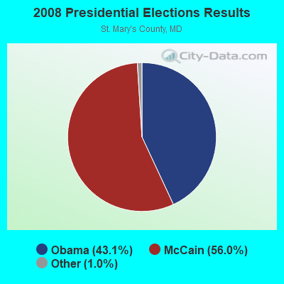
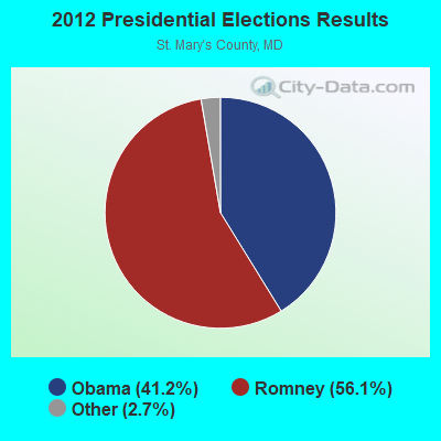
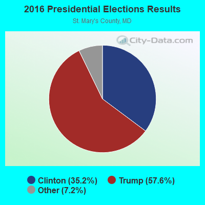
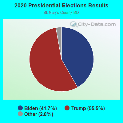
Graphs represent county-level data. Detailed 2008 Election Results
Religion statistics for District 7, Milestown, MD (based on St. Mary's County data)
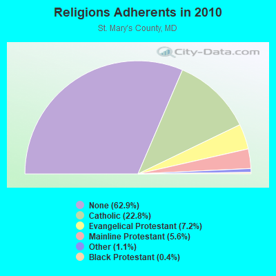
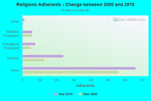
| Religion | Adherents | Congregations |
|---|---|---|
| Catholic | 24,014 | 15 |
| Evangelical Protestant | 7,519 | 35 |
| Mainline Protestant | 5,862 | 21 |
| Other | 1,206 | 7 |
| Black Protestant | 377 | 3 |
| None | 66,173 | - |
Food Environment Statistics:
| Here: | 1.60 / 10,000 pop. |
| Maryland: | 1.96 / 10,000 pop. |
| St. Mary's County: | 0.10 / 10,000 pop. |
| Maryland: | 0.07 / 10,000 pop. |
| Here: | 1.00 / 10,000 pop. |
| Maryland: | 1.22 / 10,000 pop. |
| St. Mary's County: | 2.79 / 10,000 pop. |
| Maryland: | 2.05 / 10,000 pop. |
| This county: | 5.59 / 10,000 pop. |
| Maryland: | 5.40 / 10,000 pop. |
| St. Mary's County: | 8.4% |
| Maryland: | 9.1% |
| This county: | 28.9% |
| Maryland: | 26.7% |
| St. Mary's County: | 16.8% |
| Maryland: | 15.5% |
7.37% of this county's 2021 resident taxpayers lived in other counties in 2020 ($70,801 average adjusted gross income)
| Here: | 7.37% |
| Maryland average: | 7.42% |
0.13% of residents moved from foreign countries ($1,142 average AGI)
St. Mary's County: 0.13% Maryland average: 0.05%
Top counties from which taxpayers relocated into this county between 2020 and 2021:
| from Charles County, MD | |
| from Calvert County, MD | |
| from Prince George's County, MD |
7.28% of this county's 2020 resident taxpayers moved to other counties in 2021 ($75,710 average adjusted gross income)
| Here: | 7.28% |
| Maryland average: | 7.91% |
0.09% of residents moved to foreign countries ($968 average AGI)
St. Mary's County: 0.09% Maryland average: 0.04%
Top counties to which taxpayers relocated from this county between 2020 and 2021:
| to Calvert County, MD | |
| to Charles County, MD | |
| to Prince George's County, MD |
Strongest AM radio stations in District 7, Milestown:
- WWGB (1030 AM; daytime; 50 kW; INDIAN HEAD, MD; Owner: GOOD BODY MEDIA, LLC)
- WPTX (1690 AM; 10 kW; LEXINGTON PARK, MD; Owner: SOMAR COMMUNICATIONS, INC.)
- WTEM (980 AM; 50 kW; WASHINGTON, DC; Owner: AMFM RADIO LICENSES, L.L.C.)
- WPGC (1580 AM; 50 kW; MORNINGSIDE, MD; Owner: INFINITY WPGC(AM), INC.)
- WBIS (1190 AM; 50 kW; ANNAPOLIS, MD; Owner: NATIONS RADIO, LLC)
- WCBM (680 AM; 50 kW; BALTIMORE, MD; Owner: WCBM MARYLAND, INC.)
- WTOP (1500 AM; 50 kW; WASHINGTON, DC; Owner: BONNEVILLE HOLDING COMPANY)
- WRVA (1140 AM; 50 kW; RICHMOND, VA; Owner: CLEAR CHANNEL BROADCASTING LICENSES, INC.)
- WMET (1150 AM; 50 kW; GAITHERSBURG, MD; Owner: BELTWAY ACQUISITION CORPORATION)
- WKCW (1420 AM; 50 kW; WARRENTON, VA; Owner: WAY BROADCASTING, INC.)
- WTAR (850 AM; 50 kW; NORFOLK, VA; Owner: SINCLAIR COMMUNICATIONS)
- WBAL (1090 AM; 50 kW; BALTIMORE, MD; Owner: HEARST RADIO, INC.)
- WKDL (730 AM; 8 kW; ALEXANDRIA, VA; Owner: MEGA COMMUNICATIONS OF ALEXANDRIA LICENSEE, LLC)
Strongest FM radio stations in District 7, Milestown:
- WSMD-FM (98.3 FM; MECHANICSVILLE, MD; Owner: SOMAR COMMUNICATIONS, INC.)
- WGRQ (95.9 FM; COLONIAL BEACH, VA; Owner: TELEMEDIA BROADCASTING, INC.)
- WKIK-FM (102.9 FM; CALIFORNIA, MD; Owner: SOMAR COMMUNICATIONS, INC.)
- WMDM-FM (97.7 FM; LEXINGTON PARK, MD; Owner: SOMAR COMMUNICATIONS, INC.)
- WWZZ (104.1 FM; WALDORF, MD; Owner: BONNEVILLE HOLDING COMPANY)
- WBZS-FM (92.7 FM; PRINCE FREDERICK, MD; Owner: MEGA COMMUNICATIONS OF PRINCE FREDERICK LICENSEE, LLC)
- WRAR-FM (105.5 FM; TAPPAHANNOCK, VA; Owner: RAPPAHANNOCK COMMUNICATIONS, INC.)
- WNNT-FM (100.9 FM; WARSAW, VA; Owner: NORTHERN NECK & TIDEWATER COMMUNICATIONS, INC)
TV broadcast stations around District 7, Milestown:
- WIAV-LP (Channel 58; WASHINGTON, DC; Owner: ASIAVISION, INC.)
- W52AX (Channel 52; LEONARDTOWN, MD; Owner: SATELLITE VIDEO BROADCASTING)
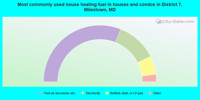
- 61.9%Fuel oil, kerosene, etc.
- 23.2%Electricity
- 10.7%Bottled, tank, or LP gas
- 2.8%Wood
- 1.4%Utility gas
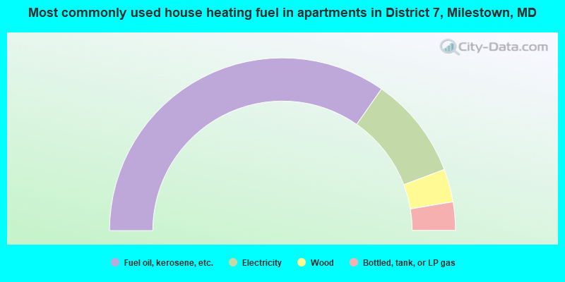
- 69.4%Fuel oil, kerosene, etc.
- 19.1%Electricity
- 6.2%Wood
- 5.3%Bottled, tank, or LP gas
District 7, Milestown compared to Maryland state average:
- Unemployed percentage significantly below state average.
- Black race population percentage below state average.
- Hispanic race population percentage significantly below state average.
- Median age above state average.
- Foreign-born population percentage significantly below state average.
- Length of stay since moving in significantly above state average.
- Number of rooms per house significantly below state average.
- House age significantly below state average.
- Number of college students below state average.
- Percentage of population with a bachelor's degree or higher significantly below state average.
District 7, Milestown on our top lists:
- #87 on the list of "Top 100 low-educated but high-earning cities"
- #61 on the list of "Top 101 counties with the largest number of people moving in compared to moving out (pop. 50,000+)"
- #79 on the list of "Top 101 counties with the lowest total withdrawal of fresh water for public supply (pop. 50,000+)"
- #90 on the list of "Top 101 counties with the highest percentage of residents relocating to foreign countries in 2011 (pop. 50,000+)"
- #98 on the list of "Top 101 counties with the highest percentage of residents relocating from foreign countries between 2010 and 2011"